


Serviços Personalizados
Artigo
 Inglês (pdf)
 Artigo em XML
 Referências do artigo
Indicadores

Links relacionados
-
 Citado por Google
 -
 Similares em Google
Compartilhar

 Permalink
Journal of the Southern African Institute of Mining and Metallurgy
versão On-line ISSN 2411-9717
versão impressa ISSN 2225-6253
J. S. Afr. Inst. Min. Metall. vol.113 no.7 Johannesburg Jan. 2013
CONFERENCE PAPERS
DIAMONDS—SOURCE TO USE 2013
KX36-rediscovering the diamond exploration potential of the central Kalahari in Botswana
A.J. RogersI; T.G. HoughII; J.M. DavidsonI
IPetra Diamonds SA (Pty) Ltd.
IIPetra Diamonds Botswana (Pty) Ltd.
ABSTRACT
The KX36 kimberlite was discovered using a high-resolution gradient aeromagnetic survey, with follow-up detailed ground geophysics and deflation soil sampling used to assess and prioritize the geophysical anomalies identified from the initial aeromagnetic survey. Prospect drilling intersected kimberlite in the first hole drilled on the KX36 anomaly. Preliminary evaluation has shown that KX36 is diamondiferous, and a more detailed evaluation and sampling programme is currently underway.
The area around KX36 has been prospected by numerous companies over the last few decades, with sporadic kimberlite indicator mineral (KIM) recoveries in regional deflation sampling indicating the possible presence of kimberlites, but without sufficient resolution to 'home in' on specific targets. Previous (lower resolution) aeromagnetic surveys and soil sampling campaigns also did not define anomalies with sufficient detail to guide prospect drilling effectively.
The discovery of KX36 highlights the prospectivity of areas of Botswana under deep Kalahari cover that have been explored previously.
Keywords: kimberlite exploration, central Kalahari, overburden, high resolution aeromagnetics, deflation sampling, KIM.
Introduction
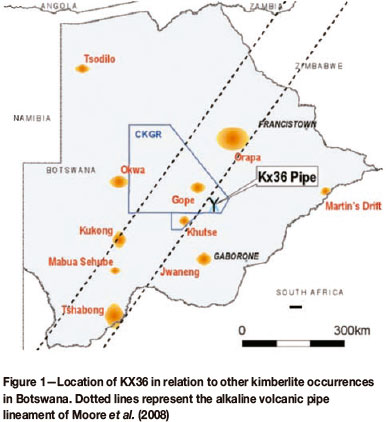
The KX36 kimberlite discovery is situated 200 km north-west of Gaborone in the southeast extremity of the Central Kalahari Game Reserve (CKGR) in Botswana (Figure 1). It lies approximately 60 km from nearest known kimberlite (Ghaghoo - formerly Gope 25), inboard of the 90 Ma north-east trending alkaline volcanic pipe lineament (Moore et al., 2008). The KX36 kimberlite is covered by 80 m of Kalahari overburden comprised of 60 m of unconsolidated sand overlying a further 20 m of calcrete and silcrete. The Kalahari cover overlies Karoo-age (Stormberg) basalts that are at least 400 m thick, which are presumed to overlie Ntane sandstone at depth. The expanse of magnetically noisy Stormberg basalts within the Kalahari basin in Botswana has historically hampered the discovery of kimberlites using magnetics as a primary exploration tool, especially where the magnetic response is attenuated by thick Kalahari overburden.
The KX36 discovery highlights the prospectivity of areas that have been explored numerous times in the past without success -primarily due to thick overburden, bedrock geology not amenable to geophysical exploration, and exploration programmes with insufficient resolution to identify target areas effectively. It also illustrates that detailed and focused exploration can discover kimberlites that were overlooked previously by combining historical prospecting information with modern prospecting techniques in a cost- and time-efficient manner
Exploration history of the KX36 area
The central Kalahari has been an exploration target for kimberlite since the extremely successful kimberlite exploration campaign of Falconbridge in the 1970s and 1980s, which utilized aeromagnetics to discover the Kukong and Tsabong kimberlite fields in areas of known kimberlite indicator mineral (KIM) occurrences. This was followed by a widely spaced regional soil sampling campaign over central Botswana that was used to define areas for further aeromagnetic surveys which, in turn, led to the discovery of the kimberlite Gope 25 (Daniels, 2004).
Subsequent to the exploration activities of Falconbridge the central Kalahari area has been covered by numerous kimberlite exploration campaigns. Soil sampling has usually been combined with aeromagnetics, but in the south-eastern portion of the CKGR around KX36 the resolution of the information has never been sufficiently detailed to guide exploration to the source of the sparse concentrations of KIM grains that were recovered by soil sampling in areas of deep Kalahari cover. Figure 2 indicates the prospecting license areas that are described in the following narrative.
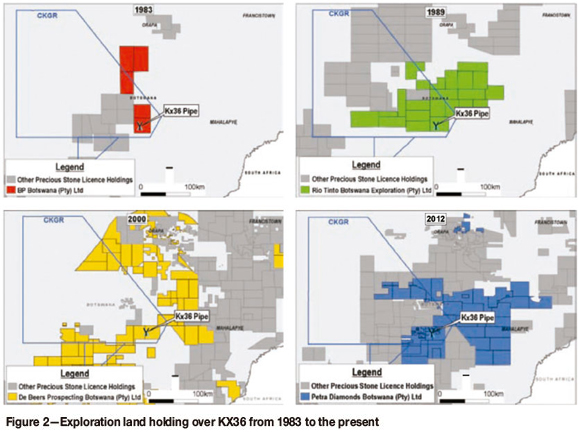
Apart from the reconnaissance sampling of Falconbridge, the first documented work done in the general area of KX36 was by BP Botswana (Pty) Ltd between 1981 and 1983. The work programme consisted of a low-level aeromagnetic survey (250 m line spacing, 60 m flying height) from which 14 targets were selected for magnetic ground follow-up (200 m line spacing, 50 m station spacing). Twelve targets were selected for reconnaissance gravity surveying, which comprised two north-south lines across each anomaly, together with one east-west line. Nine targets were drilled without success, and it was concluded that the value of the aeromagnetic survey was limited by the high background noise levels, and that no kimberlite pipes were present that were readily detectable by the exploration techniques used.
In 1988 Rio Tinto Botswana Exploration started a regional soil sampling programme on a 2 km x 2 km grid. The samples were dispatched to Rio Tinto Laboratories in Johannesburg for heavy mineral separation, with selected KIM grains analysed by microprobe. Where significant KIM concentrations were recovered, or where exceptional quality KIMs were located, follow-up deflation sampling on a 1 km x 1 km grid was carried out. Sample spacing was reduced to 400 m x 400 m, then 200 m x 200 m grids in areas of interest. Ground magnetic data (200 m line spacing, 50 m station spacing) and ground gravity data (200 m line spacing, 100 m station spacing) was also collected over the areas of interest covered by more detailed soil sampling.
No obvious discrete geophysical anomalies that could be attributed to a kimberlite pipe were found. One drill target was nonetheless selected and drilled on a prominent gravity high, less than 500 m to the south of KX36. Basalt was intersected at a depth of 73 m below Kalahari cover. However, four potential KIMs (three peridotitic garnets and one chromite) were recovered from drill chips at the Kalahari interface. No further work was carried out, and the ground was relinquished in 1992.
De Beers Prospecting Botswana became interested in the area in the late 1990s and took up the ground in 1999. The work programme focused largely around 'track and trail' reconnaissance soil sampling. Very few KIM grains were recovered, with follow-up sampling being done on two small areas, one being over the kimberlite KX36. The follow-up sampling did not increase the KIM recoveries and no further work was carried out. The licence was eventually relinquished in 2006.
In 2007 prospecting licenses covering the KX36 area were awarded to Sekaka Diamonds (now Petra Diamonds Botswana).
Exploration by Petra Diamonds Botswana Ltd
Regional airborne magnetics
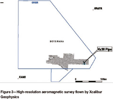
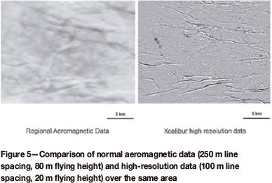
In late 2007, a horizontal gradient magnetic acquisition system designed and operated by Xcalibur Airborne Geophysics was deployed to Khutse in the central Kalahari to conduct a 51 760 line-kilometre low-level high-resolution horizontal gradient magnetic survey covering a large portion of the southern CKGR (Figure 3).
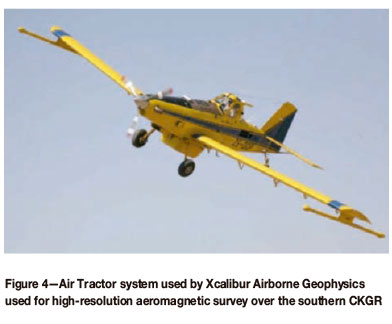
The geophysical system employed is mounted on an Air Tractor (Figure 4), and measures the total magnetic field using two wing-tip mounted caesium vapour sensors, each with a sensitivity of 1 picotesla (pT). The magnetometer samples at ten times per second, and the two sensors allow direct measurement of the horizontal magnetic gradient. Positioning is carried out by means of a differential global positioning system (DGPS) and radar altimeter, and ground clearance is measured by both laser and radar altimeter. The survey was flown at 20 m ground clearance, and 100 m line spacing. The magnetometer sampling rate allows a measurement to be taken every 7 m along flight lines
Data quality was exceptional (Figure 5), and it was possible to downward continue the anomalous magnetic field derived from gradients by 40 m to enhance the signal response before significant noise was introduced (downward continuation is a method of enhancing potential field magnetic data from geophysical surveys by calculating the response at a distance closer to the causative body than the survey height). Gradient enhancement contributed significantly towards improving the resolution of structural features mapped out in the Stormberg lavas, highlighting structural breaks that could be related to younger intrusive bodies and enhancing bulls-eye and dipole anomalies.
A target generation exercise conducted in 2008 from the final airborne magnetic data products led to the identification of 30 priority targets. Detailed ground gravity (100 m line spacing, 50 m station spacing) and ground magnetic (50 m line spacing, 25 m station spacing) survey follow-up was conducted over each target, generally on a 1 km by 1 km grid centred on the geophysical anomaly.
Each anomaly was also subject to follow-up deflation soil sampling, which consisted of a grid of nine samples centred on the anomaly and one control sample taken well off the geophysical anomaly. Screened samples were sent to Petra Diamonds' sample preparation laboratory at Helam Diamond Mine in Swartruggents for sample concentration.
Diamond Mine in Swartruggens for sample concentration. The concentrate was then hand-sorted under a binocular microscope to identify and remove any potential KIMs present.
Detailed exploration and KX36 discovery
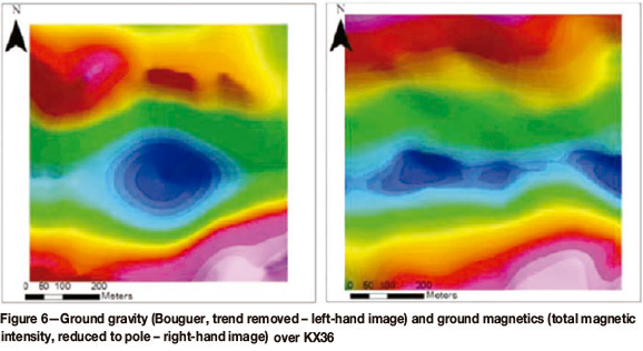
The ground magnetic results over the KX36 anomaly pointed to the possible existence of a strong, remanently magnetized intrusive body characterized by a negative magnetic anomaly, amplitude 400 nanotesla (nT), with an associated weak gravity low that appears to be structurally controlled (Figure 6). Two possible interpretations were put forward for the gravity results: either the causative body does not have an appreciable gravity anomaly associated with it, or a weak gravity signature due to a relatively small density contrast between the causative body and wallrock is being masked by the gravity signature of the prominent geological structure on which it appears to be situated.
Soil deflation sampling over the anomaly produced a significant recovery of KIMs. A total of 28 pyrope garnets and 10 chromites were recovered from the grid sampling, with grains being concentrated towards the centre of the anomaly, with a slight offset (approximately 100 m) to the south-west (Figure 7). KIM concentrations fell away dramatically off the anomaly, implying that KIM grains had been transported almost vertically to surface with minimal dispersion before being displaced to the south-west by prevailing winds.
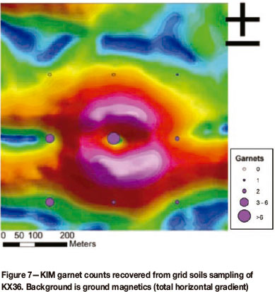
The small size of the geophysical anomaly, combined with the confined KIM dispersion halo, underpins and highlights the need for close-spaced geophysical and sampling grids for detecting smaller bodies in this environment.
Percussion drilling (6.5-inch) on target KX36 commenced towards the end of 2008. Borehole KX36/H1 intersected kimberlite from a depth of 82 m and stayed in kimberlite to end of hole at 153 m. A second borehole, situated approximately 150 m to the south-southeast of the discovery hole, intersected kimberlite between 76 m and 120 m, where the hole was stopped in kimberlite. All drill chips from the percussion holes were collected in 10 m batches, and sent to Petra's laboratory at Helam, where they were subjected to heavy mineral concentration and grain sorting.
In the discovery hole, air-flush coring was carried out between 96 m and 98 m, and again between 150 m and 153 m to obtain solid kimberlite samples for petrography and heavy mineral abundance (HMA) sampling. However, before the KIM grains had been microprobed for composition related to diamond potential, a number of -1 mm diamonds were recovered from the drill chip sampling, which gave an immediate indication of the diamond potential of the newly discovered KX36 kimberlite.
HMA sampling and kimberlite characterization
Two HMA samples were taken from the discovery hole core samples. Sample preparation involved light crushing, screening, heavy liquid separation, and grain cleaning, followed by quantitative extraction of an unbiased KIM population in the 0.3-1.0 mm size fraction with the aid of a riffle splitter and appropriate binocular microscopes. KIMs were mounted in 25 mm epoxy discs, polished, and analysed near the centre of each grain with the Cameca SX-100 electron microprobe housed at the University of Pretoria. Analyses were conducted using wavelength-dispersive spectrometry, an accelerating voltage of 20 kV, a beam current of 20 nA, and a nominal beam diameter of 3 µm. Major and minor elements were analysed on K-line peak and background positions for 10 and 5 seconds each, but increased to 30 and 15 seconds respectively to determine low-level Na concentrations in garnet. The microprobe was routinely calibrated with a selection of internationally recognized natural mantle-derived analytical standards (Jarosewich et al., 1980) including the minerals garnet (Kakanui), hornblende (Kakanui), diopside (Natural Bridge), and chromite (Teigbagi Mine).
Probe results were plotted on standard KIM discrimination plots for garnet, chromite, and clinopyroxene. For garnet the Cr2O3/CaO plot of Gurney et al. (1993) was used for peridotitic (P-type) pyrope garnets as well as the TiO2/Na2O plot for eclogitic (E-type) garnets as per Schultz (1997). All garnets were classified as per the garnet classification scheme of Grutter et al. (2004). Chromite was plotted on Cr2O3/MgO plots after Fipke et al. (1995) and Gurney et al. (1993).
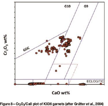
Garnet Cr2O3/CaO plot
The Cr2O3/CaO plot shows a relatively low-pressure harzburgitic G10 garnet population. Only one grain analysed plots above the graphite-diamond constraint, while other diamond stability field (DSF) G10 grains are defined by their weight percentage concentration of MnO (Grutter et al., 2004 - Figure 8).
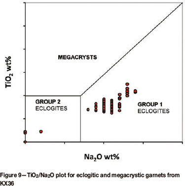
Garnet TiO2/Na2O plot
The TiO2/Na2O plot shows an exceptional Group 1 eclogitic garnet population with a composition of between 0.08 wt.% and 0.15 wt% Na2O, and 0.26 wt% and 0.5 wt% TiO2 (Figure 9). This is a strong indication that eclogitic mantle material is most likely to be the main source of diamonds for the KX36 kimberlite.
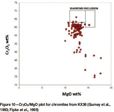
Chromite Cr2O3/MgO plot
Chromite compositions range between 30 wt% and 66 wt% Cr2O3, with MgO wt.% ranging from 10 wt% to 17.7 wt% following the typical chromite xenocryst trend. The majority of chromites analysed fall just outside the diamond inclusion and diamond intergrowth fields as defined by Gurney et al. (1993) and Fipke et al. (1995).
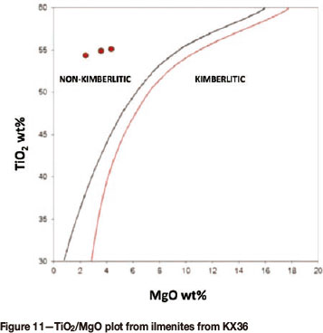
Ilmenite TiO2/MgO plot
It appears that KX36 is ilmenite-deficient. Only three ilmenite grains were recovered from the HMA sampling. The compositions of all three grains recovered fall outside of the kimberlitic field on a TiO2/MgO ilmenite compositional plot (Wyatt et al., 2004), implying they have probably been incorporated into the kimberlitic magma during its ascent (Figure 11).
Clinopyroxene thermobarometry
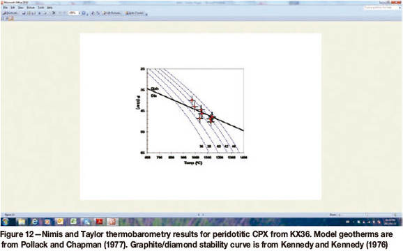
Peridotitic clinopyroxene (CPX) compositions were used to calculate pressure and temperature (PT) of formation by the Nimis and Taylor (2000) routine for thermobarometry. A limited number of grains recovered were suitable for PT calculations, but those that could be used indicate a probable 40 mW/m2 geotherm, entering the diamond stability field at 1000°C and 44 kbar pressure.
This corroborates the identification of diamonds in the percussion drill chips in the initial discovery drill-holes, and is in agreement with the KIM analyses described previously, which indicate that KX36 is diamondiferous.
Petrography
Two thin sections were prepared for petrographic analysis from the initial drill core samples. The kimberlite was classified from petrography as a hypabyssal facies, coherent, macrocrystic, altered phlogopite kimberlite and was rated as having a high interest with respect to diamond-bearing potential, based on groundmass spinels (Figure 13).
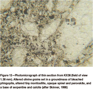
Subsequent samples sent for petrographical analysis indicated that some areas of the KX36 kimberlite display textures better described as hypabbysal coherent, transi-tioning to fragmental kimberlite.
Geophysical modelling and delineation drilling
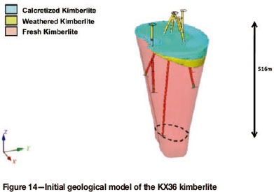
In a delineation drilling exercise carried out in 2010 a total of 1370 m of HQ core were drilled in five boreholes. Orebody/basalt host contacts were determined from four delineation boreholes, and a fifth borehole was terminated in kimberlite at a vertical depth of 516 m below surface. The top of the kimberlite was intersected at vertical depths of between 75 m and 80 m in all boreholes. The body appears to be somewhat elongated in an east-west direction, probably due to the prominent east-west structure defined in the aerial and ground geophysics.
Initial geological modelling based on the drilling in conjunction with the geophysical modelling indicates a surface area of approximately 5 hectares (ha) at the Kalahari interface. The kimberlite is overlain by approximately 60 m of Kalahari sand, and a further 20 m of calcrete and silcrete (Figure 14).
Further evaluation work
Microdiamond (MiDA) samples were taken from the core obtained during the initial delineation drilling, the results of which prompted a large-diameter reverse-flood airlift-assist drilling bulk sampling programme to be planned. This programme is in the last stages of being finalized.
Discussion of the prospectively of the central Kalahari
The discovery and preliminary evaluation work carried out on KX36 highlight the prospectivity of the central Kalahari, especially the areas of deeper Kalahari cover that have not been extensively and effectively explored and evaluated previously. The relatively poor geophysical and deflation soil sampling response highlight the need for detailed regional information for target selection and rapid screening of targets by means of detailed follow-up work on prospective areas identified.
How many more KX36-type kimberlites lie undiscovered in the CKGR and its surrounds under deep Kalahari cover? The increase in data acquisition and data processing quality and the resulting improvement in resolution of geophysical data in recent years allows the delineation of anomalies that were previously undetectable, and combining this with sensible prioritization and a sound ground follow-up in the form of ground geophysics and deflation sampling should yield more kimberlite discoveries in the years to come.
The position of KX36, being slightly offset from the 90 Ma. trend described by Moore et al. (2008), is also significant and shows there is more to be understood on the distribution of Cretaceous kimberlites in Botswana.
Conclusions
The discovery of the KX36 kimberlite proves the continued prospectivity of the central Kalahari in Botswana for kimberlite exploration, and highlights the fact that an area can never really be considered to be thoroughly explored. Advances in technology and exploration methodology can always re-ignite the potential for finding an economic ore deposit.
KX36 is, so far, an isolated kimberlite - a fact that goes against the empirical observation that kimberlite pipes usually occur in clusters. It would be strange if exploration does not turn up further kimberlite discoveries in this area of the CKGR.
Acknowledgements
The authors thanks Petra Diamonds SA (Pty) Ltd and Petra Diamonds Botswana (Pty) Ltd for permission to publish this study, and gratefully acknowledge the contributions made by everybody in the Petra Diamonds exploration team.
Dr Jock Robey and Mr Mike Skinner are thanked for their inputs into core logging and petrography respectively. Dr Deon de Bruin is thanked for co-ordinating all microprobe analyses.
References
Daniels, L. 2004. First diamonds in Botswana. Rough Diamond Review, vol. 6. pp. 31-34. [ Links ]
Grutter, H.S., Gurney, J.J., Menzies, A.H., and Winter, F. 2004. An updated classification scheme for mantle-derived garnets, for use by diamond explorers. Lithos, vol. 77. pp. 841-857. [ Links ]
Gurney, J.J., Helmstaedt, H., and Moore, R.O. 1993. A review of the use and application of mantle mineral geochemistry in diamond exploration. Pure and Applied Chemistry, vol. 65. pp. 2423-2442. [ Links ]
Jarosewich, E., Nelen, J.A., and Norberg, J.A. 1980. Reference standards for electron microprobe analysis. Geostandards Newsletter, vol. 4. pp. 43-47. [ Links ]
Kennedy, C.S. and Kennedy, G.C. 1976. The equilibrium boundary between graphite and diamond. Journal of Geophysical Research, vol. 81. pp. 2467-2470. [ Links ]
Moore, A., Blenkinsop, T., and Cotterill, F. 2008. Controls on post-Gondwana alkaline volcanism in Southern Africa. Earth and Planetary Science Letters, vol. 268. pp. 151-164. [ Links ]
Nimis, P. and Taylor, W.R. 2000. Single clinopyroxene thermobarometry for garnet peridotites. Part 1. Calibration and testing of a Cr-in-Cpx barometer and an enstatite-in-Cpx thermometer. Contributions to Mineralogy and Petrology, vol. 139. pp. 541-554. [ Links ]
Pollack, H.N. and Chapman, D.S. 1977. On the regional variations of heat flow, geotherms and lithosphere thickness. Tectonophysics, vol. 38. pp. 279-296. [ Links ]
Schulze, D.J. 1997. The significance of eclogite and Cr-poor megacryst garnets in diamond exploration. Exploration and Mining Geology, vol. 6. pp. 349-366. [ Links ]
Skinner, E.M.W. 2008. Petrography of drillcore from one kimberlite in Botswana. Report WX08X029. The Wolfe Trust, Grahamstown, South Africa. 3 pp. [ Links ]
Wyatt, B.A., Baumgartner, M., Anckar, E., and Grutter, H.S. 2004. Compositional classification of 'kimberlitic' and 'non-kimberlitic' ilmenite. Lithos, vol. 77, no. 1. pp. 819-840. [ Links ]
© The Southern African Institute of Mining and Metallurgy, 2013. ISSN 2225-6253.
This paper was first presented at the, Diamonds-Source to Use 2013 Conference, 12-13 March 2013, Misty Hills Country Hotel and Conference Centre, Cradle of Humankind Muldersdrift, South Africa.

