


Serviços Personalizados
Artigo
 Inglês (pdf)
 Artigo em XML
 Referências do artigo
Indicadores

Links relacionados
-
 Citado por Google
 -
 Similares em Google
Compartilhar

 Permalink
Journal of the Southern African Institute of Mining and Metallurgy
versão On-line ISSN 2411-9717
versão impressa ISSN 2225-6253
J. S. Afr. Inst. Min. Metall. vol.113 no.7 Johannesburg Jan. 2013
CONFERENCE PAPERS
DIAMONDS—SOURCE TO USE 2013
Review of mud rush mitigation on Kimberley's old scraper drift block caves
A. HolderI; A.J. RogersI; P.J. BartlettI; G.J. KeyterII
IPetra Diamonds SA (Pty) Ltd
IIGeoStable SA cc
ABSTRACT
A major mud push occurred on the 870 m production level, scraper drift block cave at Dutoitspan diamond mine in November 2011, during which it is estimated that more than 4 400 m3 of mud engulfed the west cave. The production level was successfully evacuated during the mud push with no loss of life or injury to personnel, thanks largely to mine employees being well trained in and adhering to on-mine mud rush evacuation procedures. All access to the west cave was lost as a result of the mud push. Clean-up operations are currently under way to regain access to the production level, to establish the extent of damage to scraper drifts and equipment, and to evaluate what remedial works may be required to resume production. The magnitude of the Dutoitspan mud push necessitated a detailed investigation into the key contributing factors leading up to the incident, which are discussed in this paper. Mud rush mitigation measures in place on scraper drift block caving operations at Dutoitspan, Bultfontein, and Wesselton diamond mines in the Kimberley area are critically reviewed. Recommendations are furthermore made for enhanced mitigation based on mud rush risk profiles derived for different production areas in these old scraper drift block caves.
Keywords: mud push, mud rush, scraper drift, block cave, mitigation factors, risk profiles, risk management structure.
Introduction
Kimberley Underground Mines JV mines diamonds from three kimberlite pipes, namely at Dutoitspan, Bultfontein, and Wesselton mines. The Dutoitspan pipe was discovered in 1870, Bultfontein in 1871, and Wesselton in 1891; initial open-pit mining of these pipes was later followed by chambering, block caving, and sub-level caving (Cleasby et al., 1975). The mines are located on the outskirts of town immediately to the south-east of Kimberley in the Northern Cape Province, South Africa. Mining currently takes place by scraper drift block caving, and at Bultfontein by rim loading on old mining levels above the current scraper drift block cave.
Mud rushes and pushes are sudden inflows of mud from drawpoints or other underground openings, and pose a serious hazard in underground mass mining of kimberlite pipes in the Kimberley region. The rates of mud inflows are often such that escape of personnel in their path is most unlikely, and they also result in severe damage to infrastructure (Butcher et al., 2005). Although the sources of mud in different mines, mud rush mechanisms, trigger mechanisms, and warning signs are generally quite well understood (Butcher et al., 2000, 2005; Brown, 2007), accurate prediction of the exact time and location of a mud rush or push is not possible. As a result, best practice to combat mud rushes involves (Butcher et al., 2000):
Draw control to ensure uniform draw profiles across the cave footprint, thereby limiting isolated draw, which increases the chances of mud from the overlying waste cap being drawn down into the production level
History of mud rushes at Dutoitspan Mine
The production footprint of the Dutoitspan 870 Lvl scraper drift block cave is shown in Figure 1, with scraper drift numbers indicated for ease of reference. The block cave was historically drawn as two separate caves, with production from the East Cave (Drifts 1 to 7) far exceeding that from the West Cave (Drifts 8 to 15), see Figures 2 and 3.


Material drawn from the more mature East Cave was much finer than that drawn from the West Cave, and was thus more prone to mud formation (Du Toit, 2005), resulting in several mud rush incidents in Drift 1 as well as mud pushes in Drifts 4, 5, and 6 in the late 1990s and early 2000s. Draw from Drifts 1 and 2 were therefore increased in an effort to get water and mud to migrate to the east end of the cave. This met with limited success and draw from Drifts 1 and 2 was stopped between 2003 and 2004, and, shortly thereafter the whole East Cave was abandoned. Production thereafter continued from only the West Cave until a fatality occurred following a mud rush from Drift 9 in 2005 which resulted in the closure of Dutoitspan mine (Du Toit, 2005). The 870 Lvl scraper drift block cave was re-opened in May 2010 following acquisition of the mine by Petra Diamonds.
Draw strategy up to November 2011
Re-opening of the 870 Lvl scraper drift block cave at Dutoitspan mine was well under way by the time the November 2011 mud push occurred. The long-term strategy focused on re-establishing the East Cave in an effort to control water and mud inflows while continuing production from the West Cave. By end of November 2011, progress with implementation of this strategy was as follows:
- Drift 8 had collapsed at Drawpoints 8 and 9
- Drift 9 had not been re-opened following the 2005 mud rush, with mud and water continuing to report to this drift
- Drift 10 had collapsed from Drawpoint 11 all the way to the back of the cave.
The November 2011 mud push at Dutoitspan
The mud push at Dutoitspan occurred at about 4.30 pm on Tuesday 22 November 2011 at the start of the afternoon shift. Shift start-up was still in progress, with three employees working in Drift 13 in the West Cave, pinch-barring drawpoints as part of the mine's normal start-up procedure. Start-up work was also in progress elsewhere on the production level. The start-up work in Drift 13 began at the northern return airway (RAW) end of the cave and was proceeding towards the rim tunnel on the south side. There was water on the footwall in part of the drift where repairs were being carried out, but all the drawpoints were dry. The work crew reached Drawpoint 9, which was hanging high, and they moved on to Drawpoint 4. At that point, they noticed a hot wind coming from the cave, followed seconds later by a second, stronger wind which kicked up dust in the drift, and they started running. They triggered the mud rush alarm at the drift entrance and shouted to other personnel on the production level to evacuate. The Drift 13 crew ran past the front of Drift 15, exiting the production level via the access ramp at the western end of the rim tunnel. While taking the corner at the top of the access ramp, they heard the mud slam into the pipework in the rim tunnel behind them, at which point the air alarm also felt silent. However, the whole of Dutoitspan 870 Lvl was successfully evacuated without any injury to personnel.
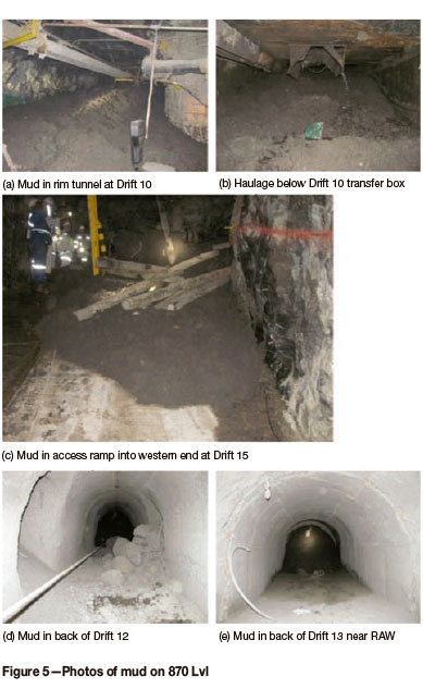
The extent of mud inundation in the West Cave is shown in Figure 4 after an estimated 4 420 m3 of mud entered 870 Lvl; also see the photos in Figure 5 (a) to (e). Mud flooded the whole of Drift 13, almost all the way up to the RAW, and two-thirds of Drift 12. It pushed into the rim tunnel on the south side, flooding the whole rim tunnel from Drift 10 in the east, past Drift 15 in the west and down the access ramp via which the Drift 13 crew escaped. The winches and ground transfer boxes (i.e. 'chinamen') at the entrances to Drifts 11 to 15 were also flooded, with mud spilling through the open transfer boxes and flooding the haulage directly below. The extent to which mud pushed towards the back of Drift 12 suggests that mud entering Drift 12 through a drawpoint rather than pushing in through the front of the drift. In other words, the mud push entered the production level via both Drifts 12 and 13.

The distances the Drift 13 crew had to run up to the point when the mud reached the rim tunnel were approximately 33 m from Drawpoint 4 to reach the entrance to Drift 13 at the rim tunnel and another 40 m from Drift 13 entrance up to the rim tunnel corner west of Drift 15. A rough estimate based on assumed running speeds suggest it took maximum of 14 seconds total from the time of the second air rush up to the point when mud engulfed the rim tunnel: 8 seconds at 15 km/h to reach the rim tunnel from Drawpoint 4 and a further 6 seconds at 25 km/h to reach the rim tunnel corner when exiting 870 Lvl.
In the aftermath, all agreed that the main factor to which successful evacuation of the 870 Lvl could be attributed was that of a workforce well trained in identifying and reacting to mud rush early warning signs (air rush preceding a mud rush or push) and in following standard evacuation procedures (sound the alarm, evacuate). It was also most fortunate, given the amount of mud that entered the 870 m production level, that this was a mud push rather than a mud rush, which in all likelihood would have caught the Drift 13 crew inside the drift before the mud rush alarm could have been sounded.
It was furthermore concluded that the mud must have come from relatively high up in the caved column above 870 Lvl, for the following reasons:
Factors contributing to the Dutoitspan mud push
A full review of available draw control data and geotechnical information was carried out following the November 2011event, to establish the factors contributing to the mud push occurring. The review focused on (a) identifying sources of water ingress and moisture conditions in the cave; (b) reviewing patterns of cave draw down in the months prior to the mud push; (c) depletion levels and waste entry; and (d) reviewing the structural condition/status of drawpoints.
Various sources of water ingress into the Dutoitspan cave were identified as follows:
Despite these sources of water ingress, the October 2011 moisture condition plot for 870 Lvl in Figure 6 shows that the West Cave was relatively dry compared to the East Cave, except for water inflows at the host rock/pipe contact in the front of Drift 15.

Cave drawdown patterns in the months prior to the November 2011 mud push were reviewed by producing plots of tons drawn for the year (Figure 7a), 6 months (Figure 7b), and 3 months (Figure 7c) preceding the mud push. The plots clearly show is that although cave drawdown over the year preceding the mud push was more or less evenly spread over the footprint of the West Cave, draw patterns shifted in the latter part of this period, with most of the draw between September and November 2011 coming from the front of the West Cave in Drifts 13 to 15 and the central portion of Drift 12.


Figures 2 and 3 show that the East Cave generally was 130% depleted in terms of the allocated reserve included in the life of mine plan for 870 Lvl. The West Cave, on the other hand, showed a different draw pattern, with Drifts 9, 11, 13, and 15 at between 80% and 100% depletion, while Drifts 8, 10, 12, and 14 were at much lower depletion levels. The reason for this drawdown pattern in the West Cave dates back to the way the cave was developed, with the uneven- numbered drifts being constructed ahead of the undercut while the even-numbered drifts were constructed later, in the de-stressed zone below the undercut. Figure 8(a) shows that some waste was reporting to drawpoints in the back of Drift 13 during March 2011, whereas by November 2011, waste started reporting across various parts of the West Cave footprint as shown in Figure 8(b).


The structural condition of drawpoints in the West Cave in November 2011 is schematically presented in Figure 9. This plot shows why draw shifted towards the front of the cave in the latter half of 2011, with badly damaged drawpoints (A-class drawpoints) in Drifts 11, 14, and 15 making it impossible to draw the central and back portions of these drifts. This resulted in severe isolated draw from the front of the cave and from Drifts 12 and 13, which were still in reasonably good condition compared to the other drifts in the West Cave.

To summarize the findings of the above review:
The presence of significant amounts of water in the caved muck, the level of depletion of the West Cave, and severe isolated draw in parts of the West Cave, combined, are therefore considered the main causes of the November 2011 mud push.
Mud rush risk management strategy
As a result of the findings of the above review, a mud rush risk management strategy was developed at the request of mine management to assess the mud rush potential at individual drawpoints in a scraper drift block cave. Mud rush risk scoring systems in use at three other Petra Diamonds mines, namely at Cullinan, Finsch, and Star, as well as at Mt Lyell Mine (Copper Mines of Tasmania) and at Freeport (Rio Tinto) were reviewed. Reference was also made to SIMRAC work on mud rushes (Butcher et al., 2000) and to audit protocols in use in Australia to assess the risk of inrushes and subsidence (WMC, 2003).
The risk scoring process adopted for scraper drift block caves at Kimberley Underground Mines JV evaluates all the key contributing factors to mud rush risk at drawpoints as set out in Tables I to IX. The scores assigned to the different contributing factors listed in these tables were derived empirically using engineering judgment combined with a reverse-engineering approach to give 'very high' risk scores at drawpoints and/or in those parts of the 870 Lvl production footprint where mud rushes or pushes have occurred over the last 5 to 10 years - up to and including the November 2011 mud push.


How does the risk scoring system work? Individual risk scores from Tables I to IX are added to derive a total risk score for every drawpoint on the production level. Moving average risk scores are then determined for each drawpoint to assess the increased (or reduced) risk level at a drawpoint due to changes over time in:
Mud rush risk plots are then generated, and presented and discussed at the mine's monthly draw control meetings, as follows:
The colour coding used on these mud rush risk plots and the average risk scores shown for individual drawpoints, as well as for different drifts and parts of the production level, are evaluated in terms of the mud rush risk matrix presented in Table X, with risk tolerance levels, global risk mitigation, and immediate mitigation actions to be implemented as outlined.
The ranges in risk rating indicated in Table X, namely:
were reverse-engineered (or 'calibrated') to give a relatively good correlation with mud push and mud rush incidents that have occurred at Dutoitspan mine over the last 5 to 10 years. Figure 10 shows the 3-month moving average plot as an example of a typical result obtained).
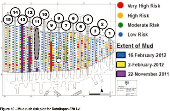
Figure 10 shows very high mud rush risk potential in the front part of the West Cave as well as in Drifts 12 and 13 where the November 2011 mud push occurred, in Drift 9 where the 2005 mud rush occurred, and in Drifts 1, 4, and 5 as well as in the back of Drift 6 in the East Cave where mud rushes and pushes have occurred in the past. It furthermore indicates a very high mud rush risk potential in the central portion of Drift 7, which is where a small mud push developed in early February 2012, about 3 months after the November 2011 mud push in the West Cave. A smaller mud push, which occurred mid-February 2012 in Drift 8, however, was not 'predicted'.
Implementation
Mud rush risk scores and results obtained from this reverse-engineering 'calibration' exercise were considered to adequately reflect actual risk profiles in the Dutoitspan 870 Lvl scraper drift block cave by mine management, and a decision was made to implement the system in operating scraper drift block caves at the neighbouring Bultfontein and Wesselton mines.
As an example, Figure 11 gives the 3-month moving average mud rush risk scores for Bultfontein 845 Lvl for November 2012. The plot indicated a high risk score at Drawpoint 21 in Drift 5. A review of the draw control data showed that this was a badly damaged drawpoint (or A-class drawpoint) from which more than 300 scoops of material was drawn during November 2012, which equated to a relatively high rate of draw compared with draw from many other drawpoints in the cave. A draw control decision was therefore made to repair Drawpoint 21 and to limit draw from this area to reduce the risk score for this drawpoint to a more acceptable level.

Conclusions
An integrated mud rush risk management strategy was developed and implemented in operating scraper drift block caves at Kimberley Underground Mines JV following a large mud push that occurred on the 870 m production level at Dutoitspan mine in November 2011. The risk scoring system adopted was first calibrated to give a good correlation with historical data from 870 Lvl at Dutoitspan mine.
Implementation of the system in operating scraper drift block caves at the neighbouring Bultfontein and Wesselton mines has allowed earlier identification of drawpoints and production areas within the cave footprint with a high mud rush risk potential. This has resulted in improved scheduling of remedial work and strip planning. Integrating all the draw control data into a single risk score for each individual drawpoint allows for easy visual presentation of data, as a result of which discussions at draw control meetings are more focused to address high-risk areas.
Dewatering drilling during 2012 furthermore intersected a major groundwater strike immediately north-west of the Dutoitspan pit, with pumping from the borehole yielding more than 8 000 litres per hour on a sustained basis. Water flowing into the pit from this area has since dried up and the pool of water on top of the caved muck pile in the bottom of the pit has disappeared. A lot of work has also been successfully completed in lining and repair of surface stormwater drains to improve surface water management in the area, thereby reducing water ingress into the Dutoitspan cave.
Finally, work continues to remove the mud from 870 Lvl, to recover equipment and machinery lost during the event, and to assess the extent of damage caused to the 870 m production level.
Acknowledgements
Publication of this work would not have been possible without the permission of Petra Diamonds SA (Pty) Ltd and the wholehearted support of the mine management team at Kimberley Underground Mines JV.
The data and risk score plots were prepared by Mr Clive Fanti, GIS analyst with Petra Diamonds SA (Pty) Ltd, whose contribution is gratefully acknowledged.
The many discussions held with Mr Gerry Hilton, recently retired Geotechnical Officer from Kimberly Underground Mines JV, regarding the history, as well as ongoing operation, of these old scraper drift block caves proved invaluable during the development and implementation of the mud rush risk management strategy now employed on these scraper drift block caves in Kimberley.
References
Brown, E.T. 2007. Block Caving Geomechanics. 2nd edn. The International Caving Study, 1997-2004. [ Links ]
Butcher, R.J. 2000. Hazards associated with the mining of diamondiferous pipes. CIM Bulletin, vol. 93, no. 1037. pp. 65-67. [ Links ]
Butcher, R.J., Joughin, W.C., and Stacey, T.R. 2000. Methods of combating mudrushes in diamond and base metal mines. Booklet, SIMRAC OTH601 Project. [ Links ]
Butcher, R.J., Stacey, T.R., and Joughin, W.C. 2005. Mud rushes and methods of combating them. Journal of the Southern African Institute of Mining and Metallurgy, vol. 105. pp. 817-824. [ Links ]
Cleasby, J.V., Wright, H.J., and Davies, M.T.G. Mining practice in the Kimberley Division of De Beers Consolidated Mines Limited. Journal of the Southern African Institute of Mining and Metallurgy, Dec. 1975. pp. 247-272. [ Links ]
Du Toit, C. 2005. Mud rush accident at Dutoitspan mine, 14 January 2005: Mining method recommendations to reduce / minimise risk of further mud rushes. Internal De Beers report. [ Links ]
Hilton, G., Holder, A., Rogers, A.J., Bartlett, P.J., and Keyter, G.J. 2012. Mudrush mitigation on Kimberley's old scraper drift block caves. Risk in Rock Engineering Design Workshop, 2nd Southern Hemisphere International Rock Mechanics Symposium (SHIRMS 2012), Sun City, South Africa. [ Links ]
WMC. 2003. Major hazard audit protocol, inrushes and subsidence. SAF-MHAP-09 Rev. 2, DOCS No. 57103. [ Links ]
© The Southern African Institute of Mining and Metallurgy, 2013. ISSN 2225-6253.
This paper was first presented at the, Diamonds-Source to Use 2013 Conference, 12-13 March 2013, Misty Hills Country Hotel and Conference Centre, Cradle of Humankind Muldersdrift, South Africa.

