


Servicios Personalizados
Articulo
 Inglés (pdf)
 Articulo en XML
 Referencias del artículo
Indicadores

Links relacionados
-
 Citado por Google
 -
 Similares en Google
Compartir

 Permalink
South African Journal of Science
versión On-line ISSN 1996-7489
versión impresa ISSN 0038-2353
S. Afr. j. sci. vol.119 no.11-12 Pretoria nov./dic. 2023
http://dx.doi.org/10.17159/sajs.2023/15505
RESEARCH ARTICLE
https://doi.org/10.17159/sajs.2023/15505
Radiocarbon-dated evidence for Late Pleistocene and Holocene coastal change at Yzerfontein, Western Cape, South Africa
Stephan WoodborneI; Duncan MillerII; Mary EvansIII; Hayley C. CawthraIV, V; Stephan WinklerVI
IiThemba LABS Johannesburg, South Africa
IIDepartment of Geology, University of the Free State, Bloemfontein, South Africa
IIIDepartment of Geography, University of the Witwatersrand, Johannesburg, South Africa
IVMinerals and Energy Unit, Council for Geoscience, Western Cape Regional Office, Cape Town, South Africa
VAfrican Centre for Coastal Palaeoscience, Nelson Mandela University, Gqeberha, South Africa
VIAccelerator Mass Spectrometry and Isotope Research, Ion Beam Centre, Helmholtz-Zentrum Dresden-Rossendorf, Dresden, Germany
ABSTRACT
We report radiocarbon dates obtained from on-shore marine and near-shore terrestrial deposits near Yzerfontein, on the West Coast of South Africa. These deposits include Late Pleistocene shell concretions from the southern end of 16 Mile Beach and a marine shell deposit inland of the coastal Rooipan (Red Pan); mid-Holocene coastal pan deposits exposed by modern storm erosion of the sandy 16 Mile Beach; and four Holocene storm beach deposits on a rocky shore to the south. We interpret the results in terms of local geomorphology constraints on sea-level fluctuations. The eastern margin of Rooipan is a >40 ka elevated beach deposit in a dune cordon that separates it from the adjacent Yzerfonteinpan. Both pans have gypsum deposits up to 2 m thick formed by repeated marine overwash. Saline pan deposits that are exposed intermittently on the beach are mid-Holocene and indicate a former westward extension of Rooipan. This is in contrast to storm beaches dating 8000-2600 cal BP at higher elevations on a rocky platform further south. This suggests that a dune barrier existed seaward of the present shoreline near Rooipan at this time. The coastal changes described here show that deposition and erosion can be affected significantly by the local palaeogeomorphology and cannot be ascribed solely to sea-level change.
SIGNIFICANCE:
Mollusc shells from Yzerfontein, Western Cape Province, South Africa, show radiocarbon ages ranging from >40 000 years to a few decades before present. There is evidence for elevated sea levels between 8000 and 2600 years ago, and sea levels similar to the present in the last 2000 years. Neither the elevation of the deposits nor their ages conform to published sea-level change curves for the Western Cape coast. Inundation by rising sea levels in the Holocene was not spatially uniform. Former and present geomorphology have had a significant effect on deposition and preservation of indicators of sea-level change.
Keywords: radiocarbon dating, sea level change, west coast, palaeolagoon, marine shell
Introduction
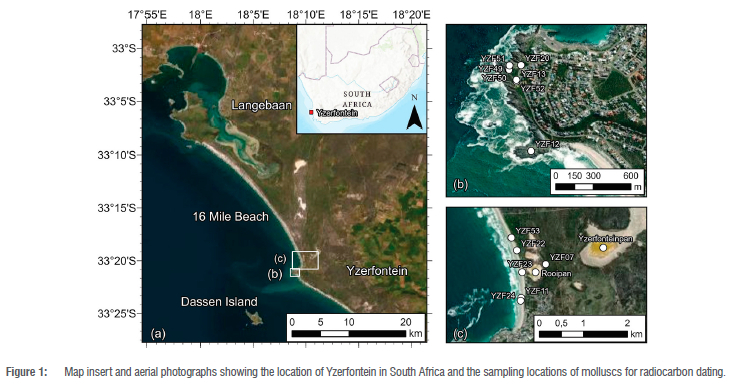
Yzerfontein Point (33° 20' 46.9" S; 18° 08' 48.8" E), situated 70 km north of Cape Town, forms a rocky promontory at the southern end of the log-spiral 16 Mile Beach (Figure 1) on the southwestern coast of South Africa. This section of coast is microtidal, but experiences a strong southwesterly swell and predominantly southerly winds that drive sand transport towards the north.1 South of Yzerfontein Point there is a wave-cut platform at 6-12 m above mean sea level (asl), following the rugged coastline for 1 km south to Schaapen Island, another rocky promontory tidally separated from the mainland. North of Yzerfontein Point there is a pocket beach and a small rocky outcrop called Rooipan se Klippe (known to geologists as Gabbro Point). North of that a coastal dune cordon separates the sandy beach from Rooipan (Red Pan), a seasonally flooded saline pan named after the red, salt-tolerant vegetation surrounding it. Another larger pan, Yzerfonteinpan, is located some 1.5 km inland and is separated from Rooipan by a vegetated dune rising to 10 m asl. 16 Mile Beach extends north, unbroken, from Rooipan se Klippe to the Langebaan Peninsula.
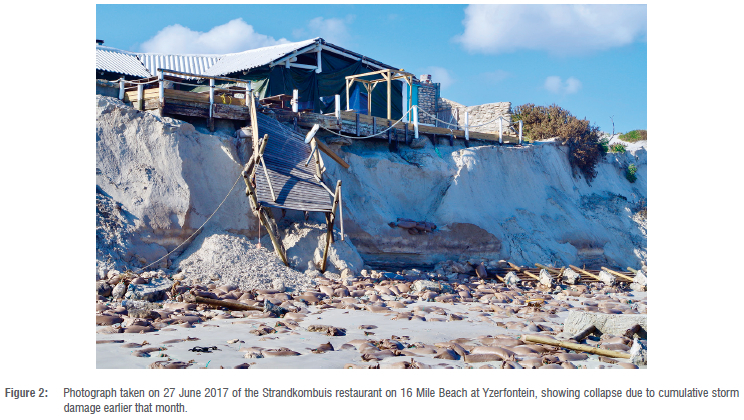
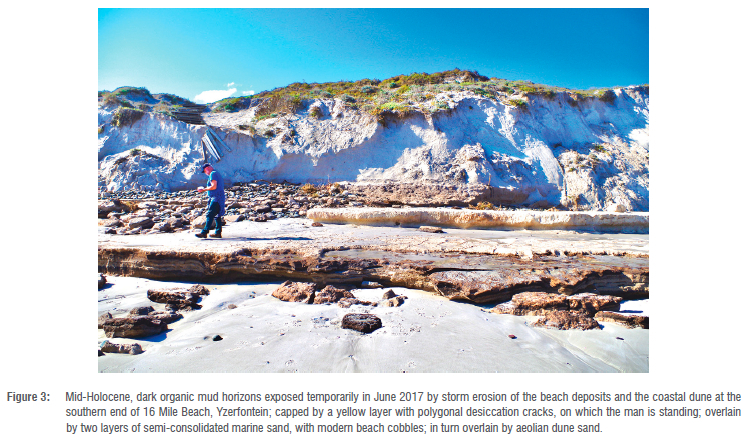
In 2017, severe storm erosion of the coastal dune at the southern end of 16 Mile Beach caused significant destruction of coastal infrastructure (Figure 2), and focused attention on the vulnerability of the local coastal dune system.2 This erosion also temporarily exposed dark, organic mud horizons containing numerous shells of the diminutive terrestrial snail Tomichia ventricosa in the beach seaward of the present coastal dunes (Figure 3). This anomaly stimulated further investigation of various onshore, near-coastal deposits in order to characterise local palaeoenvironmental change. We sampled molluscs and sediment from various near-shore deposits for radiocarbon dating in order to establish the sequence of depositional and erosional events leading to the configuration of the local modern shoreline. The main aim of this paper is to explain the apparently anomalous occurrence of pan deposits seaward of the modern dune cordon, and not to contribute to refinement of the local Holocene sea-level curve. For a comprehensive review of sea-level change in southern Africa since the Last Glacial Maximum, see Cooper et al.3
Methods
Various locations on the wave-cut platform are conveniently named with concrete markers, and we use these names to identify our samples. We radiocarbon-dated disarticulated individual shell or shell fragments of Choromytilus meridionalis from elevated deposits on Schaapen Island (YZF12), Skuimgat (YZF13 & 52) and Spuitgat (YZF49-51) on the coastal wave-cut platform, and from the head of a narrow gulley at Duiwenes (YZF20 & 21). We also dated carbon-rich sediments and a composite of several Tomichia ventricosa shells from the strata temporarily exposed by modern storm erosion of 16 Mile Beach (YZF23 & 53); a composite of several modern Tomichia ventricosa shells from Rooipan for comparison; disarticulated single Donax serra shells from a semi-consolidated sand layer exposed by the storm erosion (YZF24), a shelly horizon within the present coastal dune cordon (YZF22) and an horizon on the inland dune margin of Rooipan (YZF07); and unidentified individual shell fragments from shelly concretion (coquina) from Rooipan se Klippe (YZF11). Figure 1 shows these locations.
At each sampling location the elevation was measured using a Hemisphere S320 GNSS system. The transmitter was mounted on a measured pole and held in place until it received signals from a minimum of 50 satellites. Depending on the sites measured, the resolution ranged from 0.5 cm to 30 cm in the X, Y and Z dimensions. Elevation values reported are reduced relative to mean sea level.
Each sample was etched with acid before being crushed and reacted with hydrochloric acid to evolve carbon dioxide from the carbonate.4 The carbon dioxide was distilled cryogenically, and subject to graphitisation using an iron catalyst in the presence of excess hydrogen.5 The analysis was performed on the Tandem accelerator at iThemba LABS, Johannesburg, using coal as background and oxalic acid II as a standard. All calculations followed the protocol of Zoppi.6
Radiocarbon analysis of freshwater shells may be influenced by a hard-water effect7, while results from marine shells must account for the marine reservoir effect (AR)8. These effects are time- and space-dependent functions of the aquatic environment that typically result in age determinations that are older than the true age. In order to account for the hard-water effect, we measured modern Tomichia ventricosa shells from Rooipan. Estimates of AR for the last 2600 years, and for the period 13 000-10 000 years ago are available, and we used the Western Cape estimate of 147 ± 86 years in the calibration.9 The soil organic matter result was calibrated using the SHCal20 data set10 and the marine shell samples were calibrated using the Marine20 data set11, taking into consideration the difference between the modelled and measured local AR values9. The online calibration program CALIB ver 8.2 was used (http://calib.org/) for calibrations.11
Results
Table 1 indicates the relative elevations and corresponding radiocarbon dates with their associated calibrations. Marine mollusc shell concretions (coquina) on and just north of Rooipan se Klippe yielded dates of 39 200 ± 2000 (iT-C-1971) and shells from consolidated beach sand from south of Rooipan se Klippe yielded 50 500 ± 3400 (iT-C-2133). These dates are considered to be a minimum age estimate as shell assimilates post-depositional carbon over long periods12, and after calibration these are interpreted as >40 700 cal BP and >50 000 cal BP respectively. They probably represent the Late Pleistocene (Eemian) Velddrif Formation.13,14
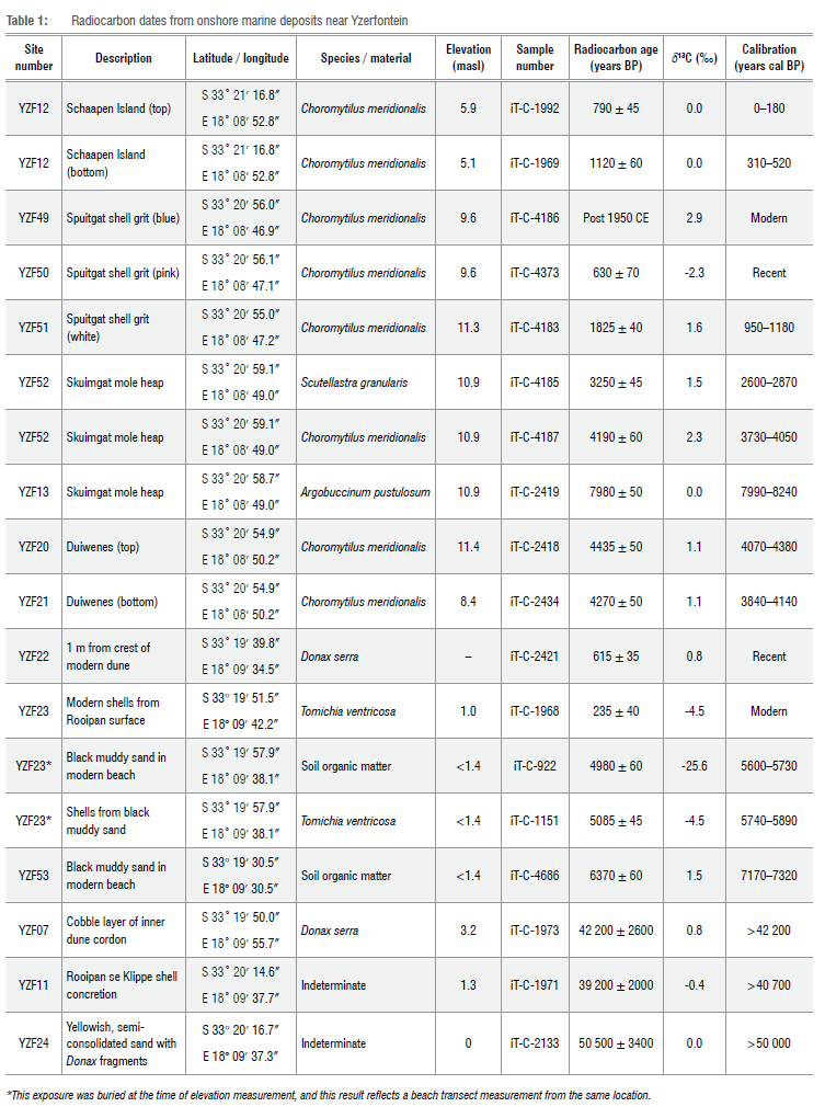
We interpret a layer of marine shells exposed in a borrow pit on the inner dune margin of Rooipan (Figure 4) as a beach because of its cobbles, relatively pristine but disarticulated bivalves, and visual similarity to the current Yzerfontein beach. The radiocarbon date of 42 200 ± 2600 (iT-C-1973) on a Donaxserra shell is also a minimum age estimate, and this calibrates to > 42 200 cal BP.
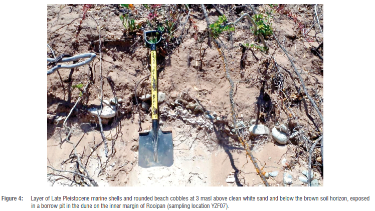
The terrestrial sediments exposed in 2017 on the beach consisted of a basal layer of finely laminated black mud about 50 cm thick, overlain by an approximately 50 cm thick layer of yellow mud, the upper surface of which had polygonal desiccation cracks. Above that was a double layer about 1 m thick of calcareous, semi-consolidated sand containing black mussel fragments, beneath 3 m of unconsolidated dune sand (Figure 3). The lower, muddy layers contained abundant shells of the pulmonate (air-breathing) snail Tomichia ventricosa (Figure 5), which inhabits coastal saline pans15, and no other molluscs that would suggest a lagoon16 or estuary17. A sample of these shells had a radiocarbon date of 5085 ± 45 (iT-C-1151) (5740-5890 cal BP), while one sample of the organic-rich mud yielded a date of 6370 ± 60 (iT-C-4686) (7170-7320 cal BP) and another that was associated with the Tomichia ventricosa shells yielded 4980 ± 60 (iT-C-922) (5600-5850 cal BP). The apparently greater age of the shells compared to the mud enclosing them is due to a hard-water effect on the shells. This is confirmed by the radiocarbon date of 235 ± 40 (iT-C-1968) obtained for modern Tomichia ventricosa collected from the surface of Rooipan. The hard-water effect is not subject to calibration. We interpret this sequence (Figure 3) as a mid-Holocene former saline pan, overlain by a sandy marine overwash deposit, capped by a late-Holocene to recent dune.
The present coastal dune cordon near the southern end of 16 Mile Beach contains several shelly layers, deposited either by storm surges or seasonal tidal overwash of low-lying portions, subsequently covered by aeolian sand. We sampled a Donax serra shell from a stratified layer about 1 m below the present dune crest and obtained a radiocarbon date of 615 ± 35 (iTh-C-2421) (280-480 cal BP). The present dune cordon is an active late-Holocene feature.
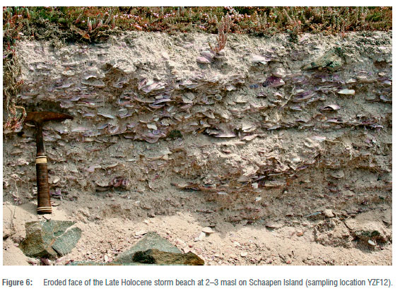
The radiocarbon dates from the storm beaches at elevations up to 11 masl on the rocky shore south of Yzerfontein Point ranged from mid-Holocene to modern. On the rocky promontory of Schaapen Island, at the head of a south-facing gulley there is a 1 m thick deposit of an unconsolidated shelly hash that is undergoing intermittent erosion by modern storm waves. The exposure is a low cliff, 2-3 masl, packed with shell fragments of a wide variety of species and sizes, and containing some pebbles and cobbles of the surrounding diorite rock (Figure 6). The deposit of comminuted and rounded shells is quite distinct in appearance and species composition from that of an archaeological midden, like the nearby one of Bakoond.18 The Schaapen Island deposit was thought to be mid-Holocene storm beach with an assumed age of around 50004000 BP, like examples at similar elevations and ages recorded elsewhere along the west coast.19 However, with radiocarbon dates of 1120 ± 60 (iT-C-1969) (310-520 cal BP) and 790 ± 45 (iT-C-1992) (0-180 cal BP) at the bottom and top, respectively, it clearly comprises late Holocene storm beach deposits.
The wave-cut platform about 6-12 masl immediately north of Schaapen Island has a mantle of water-worn mollusc shells of diverse species and sizes. There is no evidence of associated archaeological material and the water-worn nature and diversity of species and sizes suggests storm beach deposits. At Skuimgat we sampled a water-worn gastropod (possibly Argobuccinum pustulosum), a Choromytilus meridionalis shell, and a Scutellasta granularis shell from a dune mole-rat heap, and obtained early to mid-Holocene radiocarbon dates of 7980 ± 50 (iT-C-2419) (7990-8240 cal BP), 4190 ± 60 (iT-C-4187) (3730-4050 cal BP) and 3250 ± 45 (iT-C-4185) (2600-2870 cal BP), respectively. This we interpret as a mid-Holocene storm beach deposit containing a fraction of reworked older shells.
At Spuitgat there is an accumulation of mostly comminuted Choromytilus meridionalis shells to 11.3 masl. Again, there is no evidence that this is a hunter-gatherer midden, and close inspection showed distinct layers differentiated by the degree of bleaching of the shells. The white, lowermost layer dated to 1825 ± 40 (iT-C-4183) (950-1180 cal BP); a layer of semi-bleached (pink) shells dated to 630 ± 70 (iT-C-4373) ("recent"); and the uppermost unbleached (blue) layer yielded a result of 101.05 ± 0.87 percent modern carbon, which indicates the presence of bomb carbon and must post-date 1950 CE ("modern"). These are storm beach deposits on this exposed rocky promontory.
Duiwenes is a narrow, rocky gulley eroded into the 6-12 masl platform. At the head of the gulley there is a ±3-m-thick deposit of marine shells, mostly Choromytilus meridionalis, currently being eroded by terrestrial drainage through the gulley. Radiocarbon dates of 4270 ± 50 (iT-C-2434) (3840-140 cal BP) and 4435 ± 50 (iT-C-2418) (4070^380 cal BP) from near the bottom and the top, respectively, show that this is a stack of mid-Holocene storm beaches.
Discussion
The occurrence and age of these shell deposits must be viewed against other landscape features that also hold implications for sea-level change and sand supply. We highlight three features: the gypsum-rich pans immediately north of Yzerfontein (Figure 1); the evidence for an interplay between littoral dunes and saline pan features; and the presence of coeval storm beaches on the rocky promontories.
Yzerfonteinpan and Rooipan are relict Late Pleistocene features15,20 with present surfaces at 1-2 masl. Rooipan is reported to have a basal layer of "sand or shelly limestone of the Late Pleistocene (Eemian/last interglacial) Velddrift Formation"21. This deposit indicates a former, Late Pleistocene, marine embayment of unknown extent, that probably also underlies the adjacent Yzerfonteinpan. Both pans have been mined for gypsum, from a layer up to about 2 m thick.15,21 In Yzerfonteinpan this is intercalated with sand containing bleached Choromytilus meridionalis shell fragments, which indicate a Late Pleistocene, perhaps last interglacial (Eemian, 120-130 ka), age.20 In undisturbed portions of Yzerfonteinpan, there are dark surficial muddy layers, in places containing burrows and shells of Tomichia ventricosa.15,20 The surface of Rooipan has been more thoroughly disturbed by historical mining, and modern Tomichia ventricosa are found living directly on the exposed gypsiferous sand.
The gypsum deposits in both pans result from multiple, successive marine inundations over a coastal bar, followed by evaporation to a brine at least 3.35 times the salinity of sea water, to initiate precipitation of gypsum.13 The succession of a marine embayment, followed by a pan with deposition behind an overwash bar, implies a falling sea-level, possibly linked to the waning Eemian interglacial. The Late Pleistocene beach deposit at 3 masl, preserved in the dune between the two pans, shows that Rooipan must be somewhat younger than Yzerfonteinpan, but that it developed under the same regime of intermittent inundation and evaporation of sea water behind an overwash bar somewhat further west. With a falling Late Pleistocene sea level, marine overwash ceased, and this bar too eventually was stranded. The cessation of marine overwash and gypsum deposition in both Yzerfonteinpan and the ancestral Rooipan was followed by seasonal inundation by terrestrial runoff, and the deposition of the fine muddy layers inhabited by Tomichia ventricosa.
We obtained a mid-Holocene date for the organic mud and Tomichia ventricosa shells from the pan deposits preserved beneath the present beach. This implies that the ancestral Rooipan must have been more extensive between 7200 cal BP and 5600 cal BP, with a sand barrier further west than the present dune cordon. We suggest that a substantial dune barrier formed seaward of the current coastline during a Late Pleistocene sea-level lowstand. This barrier protected the ancestral Rooipan from immediate inundation by the rising early Holocene higher sea level. The barrier must have been sufficiently robust and persistent to protect the ancestral Rooipan from the contemporaneous mid-Holocene storm surges recorded by the storm beaches on the exposed rocky platform to the south of Yzerfontein Point, which evidently was not protected by such a barrier.
Eventually the barrier that protected the mid-Holocene saline pan was breached and eroded, contributing its sand to the growing Holocene dune plume22,23, the inner margin of which may form the present coastal barrier dune now protecting the residual Rooipan. Most of its former extent has been eroded by the sea, which has eroded the beach and dune margin by up to 80 m locally since 1936.1
Clearly, the storm beach deposits south of Yzerfontein Point, with various elevations above modern mean sea-level that do not correlate with their age, cannot be used as indicators of former Holocene sea levels, and the single mid-Holocene date for a saline pan just over 1 masl behind a now eroded barrier dune probably does not contribute significantly to refining the local Holocene sea-level curve.
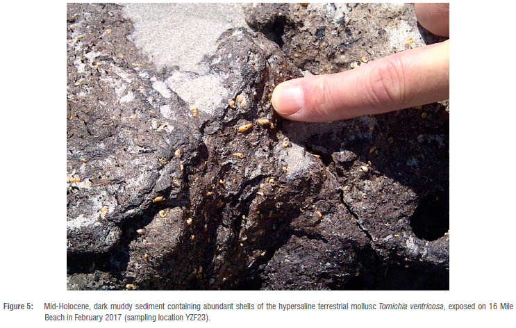
There is little correspondence between published Holocene sea-level curves for the southern African west coast.13,19,24-26 There appears to be consensus that rising sea level crossed 0 masl around 8000 years ago, with some higher indicators subsequently (Figure 7A)16, but other than that the published data are inconsistent. Nevertheless, we note that Compton16,25 has suggested a slight drop in sea-level with sub-aerial exposure of nearshore deposits at about 4500 BP. If this is the case, it may have contributed to protection of the ancestral Rooipan from mid-Holocene inundation.
The evidence presented here indicates that an open embayment existed north of Rooipan se Klippe/Gabbro Point at some point prior to 50 000 cal BP, which probably represents the Eemian sea-level highstand (Figure 7B). During the Last Glacial Maximum, lower sea level led to increased sand supply from the south, forming a dunefield to the west of the current beach. As sea level transgressed the modern level during the mid-Holocene, this dunefield resisted erosion sufficiently for an extensive ancestral Rooipan to form (Figure 7C). The dunefield that protected the ancestral Rooipan from the mid-Holocene sea-level highstand eventually breached, and overwash deposits accumulated on ancestral Rooipan. Ultimately, the beach eroded back to the modern shoreline, forming a littoral dunefield in the process (Figure 7D). The recent erosion of the southern end of 16 Mile Beach2 is likely a process that has been ongoing through the latter half of the Holocene, with a return to the presumed Eemian shoreline being a possible endpoint.
Conclusions
The southern parts of 16 Mile Beach have eroded recently2, while further north coast-parallel dunes have prograded seaward in response to the marine regression since the mid-Holocene.20 The implication is that palaeogeographic conditions were different between the southern and northern stretches of 16 Mile Beach, and the impact of sea-level change is determined by local sand supply and transport dynamics on these sandy shores. A more general implication is that local palaeoenvironmental reconstruction is crucial to interpreting local coastal change in response to changing sea level. Apparent sea-level change cannot simply be extrapolated from one area to another, even those along contiguous stretches of coastline.
It is anticipated that sea levels will rise over the coming decades in response to global climate change, and past transgressions provide a potential analogue for the impact that this may have on coastal morphology. Local sea-level rise is not a uniform 'tub filling', and our data show that local expression may be dependent on the existence of former barriers, variably resistant to erosion, that for a while may protect back-barrier pans and other landscape features vulnerable to subsequent inundation when these barriers have been breached. At the southern end of 16 Mile Beach the present dune barrier is eroding actively, its shoreward face having shifted some 30 m inland since the beginning of 2017.2 This has obvious implications for infrastructural development on top of and immediately behind the present dune cordon. Any increase in storminess due to climate change may breach the lowest portion of this narrow dune barrier, which has been eroded beyond its former crest and is now only about 3 masl. The result may be intermittent flooding of Rooipan, with further damage to built infrastructure on its margins. The ultimate expression of this process may be the loss of the present dune cordon altogether, with the beach returning to the position of the Pleistocene inner dune cordon that marks the landward edge of Rooipan.
Acknowledgements
We thank Antonieta Jerardino for discussions about the deposits on the rocky coast, and the observation that the Schaapen Island radiocarbon dates correspond with the Medieval Warm Period. Anthony Tankard contributed helpful interpretations of the deposits on 16 Mile Beach exposed by the June 2017 storm. Isak (Sakkie) de Villiers kindly gave us permission to dig an exploratory hole for sediment sampling in Rooipan on his property, and Rupert Joone is thanked for acting as an intermediary in obtaining this permission. We also thank Mauro Lourenco who prepared the map. The collection of material for geodating dating from 16 Mile Beach and the dune cordon was undertaken in terms of Research Permit CRC/202102022/006-2018/V1 from the Cape Research Centre, South African National Parks.
Competing interests
We have no competing interests to declare.
Authors' contributions
S.W.: Conceptualisation; methodology; data collection; sample analysis; data analysis; writing - revisions. D.M.: Conceptualisation; methodology; data collection; data analysis; writing - initial draft; writing - revisions; project leadership; funding acquisition. M.E.: Data collection. H.C.: Data collection. S.W.: Sample analysis.
References
1. Franceschini GF, Compton JS, Wigley RA. Sand transport along the Western Cape coast: Gone with the wind? S Afr J Sci. 2003;99:317-318. [ Links ]
2. Murray J, Adam E, Woodborne S, Miller DE, Xulu S, Evans M. Monitoring shoreline changes along the southwestern coast of South Africa from 1937 to 2020 using varied remote sensing data and approaches. Remote Sens. 2023;15(2):317. https://doi.org/10.3390/rs15020317 [ Links ]
3. Cooper JAG, Green AN, Compton JS. Sea-level change in southern Africa since the Last Glacial Maximum. Quat Sci Rev. 2018;201:303-318. https://doi.org/10.1016/j.quascirev.2018.10.013 [ Links ]
4. Douka K, Higham TF, Hedges RE. Radiocarbon dating of shell carbonates: Old problems and new solutions. Munibe Suplemento. 2010;31:18-27. [ Links ]
5. Vogel JS, Southon J R, Nelson DE, Brown TA. Performance of catalytically condensed carbon for use in accelerator mass-spectrometry. Nucl Instrum Methods Phys Res Sect B - Beam Interact Mater At. 1984;233:289-293. https://doi.org/10.1016/0168-583X(84)90529-9 [ Links ]
6. Zoppi U. Radiocarbon AMS data analysis: From measured isotopic ratios to 14C concentrations. Radiocarbon. 2010;52(1):165-170. https://doi.org/10.1017/S0033822200045112 [ Links ]
7. Philippsen B. The freshwater reservoir effect in radiocarbon dating. Herit Sci. 2013;1:24. https://doi.org/10.1186/2050-7445-1-24 [ Links ]
8. Heaton T, Köhler P Butzin M, Bard E, Reimer R, Austin W, et al. Marine20-the marine radiocarbon age calibration curve (0-55,000 cal BP). Radiocarbon. 2020;62:779-820. https://doi.org/10.1017/RDC.2020.68 [ Links ]
9. Dewar G, Reimer PJ, Sealy J, Woodborne S. Holocene marine reservoir effect correction (DR) for the west coast of South Africa. The Holocene. 2012;22(12):1481-1489. https://doi.org/10.1177/0959683612449755 [ Links ]
10. Hogg A, Heaton T, Hua Q, Palmer J, Turney C, Southon J, et al. SHCal20 southern hemisphere calibration, 0-55,000 years cal BP. Radiocarbon. 2020;62:759-778. https://doi.org/10.1017/RDC.2020.59 [ Links ]
11. Stuiver M, Reimer P. Extended 14C data base and revised CALIB 3.0 14C age calibration program. Radiocarbon. 1993;35(1):215-230. https://doi.org/10.1017/S0033822200013904 [ Links ]
12. Briant RM, Bateman MD. Luminescence dating indicates radiocarbon age underestimation in late Pleistocene fluvial deposits from eastern England. J Quat Sci. 2009;24:916-927. https://doi.org/10.1002/jqs.1258 [ Links ]
13. Tankard AJ. Pleistocene history and coastal morphology of the Ysterfontein-Elands Bay area, Cape Province. Ann S Afr Mus. 1976;69(5):73-119. [ Links ]
14. Roberts DL, Botha GA, Maud RR, Pether J. Coastal Cenozoic deposits. In: Johnson MR, Anhaeusser CR, Thomas RJ, editors. Geology of South Africa. Cape Town: Geological Society of South Africa and Council for Geoscience; 2006. p. 605-628. [ Links ]
15. Smith M, Compton JS. Origin and evolution of major salts in the Darling pans, Western Cape, South Africa. Appl Geochem. 2004;19:645-664. https://dx.doi.org/10.1016/j.apgeochem.2003.10.003 [ Links ]
16. Compton JS. Holocene sea-level fluctuations inferred from the evolution of depositional environments of the southern Langebaan Lagoon salt marsh, South Africa. The Holocene. 2001;11(4):395-405. https://doi.org/10.1191/095968301678302832 [ Links ]
17. Grindley JR, Rogers J, Woodborne MW, Pether J. Holocene evolution of Rietvlei, near Cape Town, deduced from the palaeoeconology of some mid-Holocene estuarine Mollusca. Palaeoecology Afr. 1988;19:347-353. [ Links ]
18. Orton J. Hunters or herders? Evidence from the cultural assemblages at Bakoond, Western Cape, South Africa. Before Farming. 2009;4:1-16. https://doi.org/10.3828/bfarm.2009.4.1 [ Links ]
19. Miller DE, Yates RJ, Jerardino A, Parkington JE. Late Holocene coastal change in the southwestern Cape, South Africa. Quat Int. 1995;29/30:3-10. https://doi.org/10.1016/1040-6182(95)00002-Z [ Links ]
20. Mauger C. The formation and origin of carbonate minerals in the Darling and Yzerfontein hypersaline pans, Western Cape, South Africa [thesis]. Cape Town: University of Cape Town; 2009. https://open.uct.ac.za/handle/11427/9240 [ Links ]
21. Cole DI. The metallogeny of the Cape Town area: Explanation metallogenic map sheet 3318. Pretoria: Council for Geoscience; 2003. p. 55. [ Links ]
22. Compton JS, Franceschini G. Holocene geoarchaeology of the Sixteen Mile Beach barrier dunes in the Western Cape, South Africa. Quat Res. 2005;63:99-107. https://doi.org/10.1016/j.yqres.2004.09.006 [ Links ]
23. Franceschini G, Compton JS. Holocene evolution of the Sixteen Mile Beach complex, Western Cape, South Africa. J Coastal Res. 2006;22:1158-1166. http://dx.doi.org/10.2112/05-0576.1 [ Links ]
24. Baxter AJ, Meadows ME. Evidence for Holocene sea level change at Verlorenvlei, Western Cape, South Africa. Quat Int. 1999;56:65-79. https://doi.org/10.1016/S1040-6182(98)00019-6 [ Links ]
25. Compton JS. The mid-Holocene sea-level highstand at Bogenfels Pan on the southwest coast of Namibia. Quat Res. 2006;66(2):303-310. https://doi.org/10.1016/j.yqres.2006.05.002 [ Links ]
26. Schüller I, Belz L, Wilkes H, Wehrmann A. Sedimentary evolution of lagoons along the Namibian coast reveals fluctuation in Holocene biogeographic faunal provinces, upwelling intensity and sea level. Front Earth Sci. 2022;10:898843. https://doi.org/10.3389/feart.2022.898843 [ Links ]
 Correspondence:
Stephan Woodborne
Email: sm.woodborne@ilabs.nrf.ac.za
Received: 26 Jan. 2023
Revised: 29 July 2023
Accepted: 30 July 2023
Published: 29 Nov. 2023
Editor: Jemma Finch
Funding: None

