


Servicios Personalizados
Articulo
 Inglés (pdf)
 Articulo en XML
 Referencias del artículo
Indicadores

Links relacionados
-
 Citado por Google
 -
 Similares en Google
Compartir

 Permalink
South African Journal of Science
versión On-line ISSN 1996-7489
versión impresa ISSN 0038-2353
S. Afr. j. sci. vol.119 no.9-10 Pretoria sep./oct. 2023
http://dx.doi.org/10.17159/sajs.2023/14320
REVIEW ARTICLE
The value of multibeam bathymetry in marine spatial planning in South Africa: A review
Thamsanqa F. WandaI, II; Errol A. WilesI, III; Hayley C. CawthraIV, V; Anton de WitII
ISouth African Institute for Aquatic Biodiversity, Makhanda, South Africa
IIDepartment of Geosciences, Nelson Mandela University, Gqeberha, South Africa
IIIInstitute for Coastal and Marine Research, Nelson Mandela University, Gqeberha, South Africa
IVMinerals and Energy Unit, Council for Geoscience, Cape Town, South Africa
VAfrican Centre for Coastal Palaeoscience, Nelson Mandela University, Gqeberha, South Africa
ABSTRACT
Given a growing global population and shift to embrace the blue economy, a need for marine spatial planning (MSP) has emerged in South Africa to sustainably resolve the rising conflicts over the use of marine and seabed resources and services. A well-developed marine spatial plan yields numerous ecological, social and economic benefits. These are achieved through mediating between spatially conflicting economic drivers' interests (e.g. commercial fishing, tourism, mining), preventing their activities from compromising thresholds of an environment's sustainability. Within the MSP framework, high-resolution geospatial datasets are required to document and describe the seabed in the highest possible detail. At any scale, integrated analysis of seabed geomorphology and habitats is anticipated to greatly improve the understanding of ecosystem functioning from a multidisciplinary perspective, whilst improving MSP procedures and management of marine space. South Africa is the first of few African countries to have an approved and implemented MSP framework, but is still somewhat behind globally in implementing large-scale regional hydroacoustic surveys to cover the country's vast offshore territory. The deficiency of hydroacoustic surveys is perhaps due to a relative lack of funds and poor communication about the value of multibeam echo-sounder (MBES) derived data, whilst marine geoscience remains a scarce skill in the country. This review paper presents a geological perspective of MSP and explores (1) the value that seabed mapping offers MSP specifically and (2) the need to increase seabed mapping with MBES, using a recently initiated project from the South African east coast as a case study.
SIGNIFICANCE:
The collected MBES data (our case study) provides unprecedented seabed detail of the complex reef habitat and adjacent areas within specific management zones of the uThukela Banks Marine Protected Area. We reveal seabed features and their spatial distribution at a scale not possible using earlier (singlebeam) seabed mapping techniques. These high-resolution data will enable a better understanding of east coast marine habitats whilst contributing to improved spatial management of areas within and around the uThukela Banks Marine Protected Area.
Keywords: hydroacoustic surveys, benthic habitat, biodiversity, climate change, seafloor geomorphology
Introduction
Marine spatial planning (MSP) is a process currently being employed on a global scale towards efficient management of the ocean space, and therefore the blue economy1,2 (i.e. sustainable exploitation, preservation and regeneration of the marine environment) and addressing the needs of growing global populations (e.g. Operation Phakisa2-4). Globally5-12 and locally, the introduction of an ecosystem-based mSp process towards management of the marine space is well supported.4,13,14 The decision-making process is guided by the quality of data on which it is based. At present, about 75 countries that have marine borders on all major oceans have commenced with MSP initiatives.15 Some of these countries (such as China16, Canada17,18, the United States of America's California mapping programme19, Ireland20 and Australia21) have actively applied improved technology22,23 (e.g. multibeam echo-sounders/MBES) in benthic habitat mapping, which has led to effective MSP results. A case study from the long-established Irish programme INFOMAr (integrated mapping for the sustainable development of Ireland's marine resource) showed investment benefits of seabed mapping initiative across all marine sectors to be 4-6-fold compared to the initial capital investment.24 In South Africa, the development of an MSP framework began in 20159, identifying spatial plans encompassed by the country's exclusive economic zone (EEZ). This enabled South Africa to take the lead over other African countries by being the first to have the Department of Environmental Affairs (now known as the Department of Forestry, Fisheries and the Environment) draft an MSP legislation in 201 7.4,13,25 The draft was later approved by the government as Act No. 16 of 2018.14
Globally, there is a drive to protect the ocean's biodiversity and/or ecosystems26-28; however, only 9% of the world's seabed has been mapped to resolutions at an appropriate scale for MSP and management29,30. Marine protected areas (MPAs) are a significant component of the South African MSP process, and receive an elevated status and restricted use based on their valuable environmental products and services.31 There are 41 MPAs (total area 5.4%) within South Africa's EEZ32, defined on ecosystem conservation and/or socio-economic objectives, but only a fraction of these MPAs are associated with the high-resolution geospatial context provided by MBES data (e.g. Protea Banks MPA33, the uThukela MPA34 and Cape Canyon MPA35). The management, protection and monitoring of the oceanic resources and services that are not holistically understood pose significant challenges (e.g. lacking the contribution of the abiotic factors, such as the seabed geomorphology, in an attempt to understand the declining continental shelf biodiversity).
Marine habitat and resource mapping has become a global prerequisite for spatial management of the ocean's resources and services.36,37 The availability of high-resolution bathymetric data has increased modelling capabilities in marine science.18,30,38-42 However, MBES data are only one component (although an important one) of benthic habitat mapping, which requires various inputs (e.g. seabed imagery, sediment samples, backscatter and bathymetry).
MBESs have rapidly become the preferred hydroacoustic surveying technique in marine habitat mapping for its capability to simultaneously and reliably obtain bathymetry and backscatter data.30,37,42,43 MBESs form the foundation for the Seabed 2030 initiative44 (which aims at completely assimilating data and mapping the world's seabed by 2030). This technique uses sound to collect hundreds of thousands to millions of georeferenced depth soundings which are processed to create a 3D digital terrain model of the surveyed area. Hence, MBES data capture high spatial resolution imagery of the seabed's geomorphology45 which is used to characterise marine habitats in terms of their georeferenced location, spatial extent and geomorphological characteristics38. In South Africa, the most recent of these interdisciplinary research projects was carried out in the Western Cape by Pillay et al.42, who applied machine learning and algorithms to seabed classification.
Benthic habitat mapping is recognised as a need to be expanded upon in South Africa41, because the continental shelf bathymetry has been previously recognised to be poorly resolved40. One of the benthic habitats recognised globally for the multitude of coastal goods and services it offers is reefs46 (i.e. outcropping rock on the seabed), which form the primary focus presented in the case study here. Reefs host diverse marine ecosystems47 and surveying reefs with MBES in South Africa is anticipated to improve the understanding of their functioning, besides supporting multiple resource management objectives (e.g. delineating MPAs)41,45. Seabed characteristics (e.g. depth, rugosity and substrate) and their interaction with the local oceanographic conditions form the building blocks that contribute to the functioning of marine ecosystems and structure of benthic guild (habitat provision) at regional spatial scales.30,42,48 In this paper, we aim to (1) highlight the gaps in allocating spatially restrictive boundaries without high-resolution hydroacoustic mapping within South Africa's EEZ, especially in areas demarcated as MPAs, (2) provide a link between geology, biological and oceanographic space utilising high-resolution bathymetry data, and (3) present initial results from a case study of a selected site from the uThukela MPA ACEP (African Coelacanth Ecosystem Programme) Smart Zones Project.
Multibeam echo-sounders and benthic habitat mapping
Within the South African context, there is increased interest in developing enhanced high-resolution seabed models.42 Recent marine geological mapping and marine research41,42 have presented a strong case for the possible role of MBES data in the realm of benthic habitat mapping.18,21,38 MBES provides the baseline data (bathymetry, backscatter, slope, etc.) from which the seabed and habitat maps can be derived and interpreted in conjunction with ground-truth data20, thus providing a detailed bathymetric surface which can in turn be used for planning and decision-making. In addition, backscatter intensity data provide an indication of seabed character (cf. Montereale-Gavazzi et al.49), discerning between sediment classes and consolidated seabed. The system frequencies are optimised for specific depth ranges and must be employed accordingly.36,37,43,50,51 MBES data can be processed to produce dataset derivatives (e.g. rugosity, slope, bathymetric position index and aspect maps), which offer enhanced and detailed properties of the substrate known to influence benthic diversity. Marine mapping efforts have begun to match in data quality and resolution those of the terrestrial realm18, and therefore are as informative as terrestrial topographic observations.
Methods
For this study, sites between Durban and Richards Bay were selected for MBES mapping based on (1) features identified on low-resolution regional datasets40,52 (and references therein) (2) being known recreational fishing areas (likely reefs) and (3) their location relative to the uThukela MPA management zones. Hydroacoustic surveys were carried out on the reefs and their adjacent areas in the 40-100 m depth zones, depending on site location. The Geophysics and Mapping Platform (GeMaP) provided by ACEP was used to acquire MBES data. The platform's Seabat Reson 7101 MBES and SBG systems (Navsight Apogee inertial navigation system) were used during data collection, whilst maintaining on average a ±10% overlap between the adjacent survey lines to increase data integrity at the swath edges. Sound velocity profiles were collected periodically throughout the day, monitored at <3 m/s difference between the profile velocity from the live sound velocity. Raw data were processed using HYPACK (2022) and Qinertia (v. 3.0.5966) to produce gridded (3 m cells) digital terrain models of the seabed. Golden Software Surfer (v. 23.3.202) and ESRI ArcMap 10.1 were used to visualise and interpret data and derivatives.
Case study: The uThukela Banks Marine Protected Area
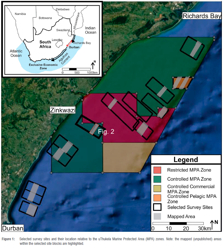
The uThukela Banks MPA (5666 km2; Figure 1) proclaimed in 201932 is situated on South Africa's wave-dominated53 east coast continental shelf. This MPA is subdivided into zones with varying degrees of accessibility and/or protection from human pressure54 (Figure 1) to regulate the declining continental shelf biodiversity55. The uThukela River terrestrial sediments and associated offshore unconsolidated material deposits have actively shaped the eastern KwaZulu-Natal (KZN) continental shelf since the break-up of Gondwana.56 Further details of the shelf stratigraphy of the area have been documented by Hicks and Green57 (and references therein). This MPA has not received much attention in terms of high-resolution MBES mapping despite encompassing an extensive subaqueous delta58,59 and multiple reef complexes noted for high biodiversity52. Green et al.34 recently carried out an extensive MBES survey, providing new insights into higher-resolved geomorphology within the uThukela Banks mPa. This extensive survey showed the value of incorporating geological data into informing MPA management (and therefore, MSP). Prior to this, low-resolution bathymetry and regional sedimentary facies had been described from the region in 2007.58 A study in 201252 developed a systematic framework for assessment of biodiversity and marine biodiversity protection for KZN by recognising spatial priorities for sustainable conservation efforts (formerly known as the SeaPLAN project). However, this was based on relatively low-resolution bathymetry data in which the geomorphology is poorly resolved. The singlebeam echosounder (SBES) mapping efforts of De Wet and Compton40 (published in 2021) do span the uThukela MPA, but only contribute low-resolution and less-detailed bathymetry. To date, through the ACEP Smart Zones Project (unpublished data), 13 of 14 selected sites have been surveyed with MBES at an average coverage of 17 km2 per site, providing ca. 230 km2 of new MBES data over key localities within and adjacent to the uThukela MPA (Figure 1).
Results
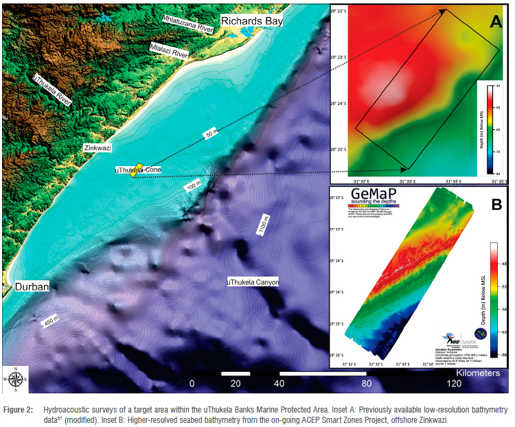
With this case study, we focus on one of the surveyed ACEP Smart Zones MPA Project sites (at 40-70 m depth range; Figure 2) which shows a locally steeply inclined (13°) seaward slope. Compared to the SBES dataset (Inset A; Figure 2)40, we note that the new (MBES) data allow a precise distinction between sediment-starved areas from those adjacent zones (i.e. either rich in sediments and/or featureless seabed), and between different types of outcrop morphology. Areas adjacent to the outcrop likely represent unconsolidated sediments described by flat-lying sediments and bedforms. These large superimposed subaqueous dunes form discontinuous fields along the mid-shelf (Inset B; Figure 2). The sediment-starved areas are characterised by exposed reef. Reef geomorphology is variable with rugged reef pinnacles and ridges bordered by low-relief reefs fringed by adjacent relatively flat and/or featureless seabed. The reefs are commonly oriented approximately coast-parallel on the inner- to mid-shelf, representing submerged shorelines.33,59 Abrupt changes in depth of the seabed, as observed on the outer edges of the reefs (Figure 2), are recognised as prominent zones of overstepped submerged shorelines.33,59
Discussion
Application of MBES to substrate analysis
The data example provided here underscores the distribution of reef and adjacent sediments (and/or featureless seabed) at this survey site. Reefs play an integral role in marine habitats as they are biodiversity hotspots on the continental shelf (e.g. Caribbean nations reefs60) and are vulnerable to both anthropogenic and natural impacts.61 Thus reefs and organisms that inhabit them benefit from proclamation of these localities as MPAs. Duran et al.62 previously reported that understanding the temporal and spatial variation of reef communities is of critical importance to monitoring stressors on health and ecosystem functioning (e.g. fishing63) and global stressors (e.g. climate change64). The high-relief reef (less vulnerable to inundation by sediments) could provide stable habitat for long-term inhabitants, whereas the low-relief reef (including the high-relief reef edges) preferentially hosts shortterm inhabitants as it is more vulnerable to burial by the dynamic sediments (cf. Harman et al.65). The interaction of the high-relief reef with the localised dynamic system induces turbulence, promoting the growth and density of substrate attached organisms66, and therefore, creating accommodation for biodiversity abundance65. This, therefore, emphasises how the seabed geomorphology is the fundamental building block to the systems that exist on and/or above its surface.42,48 The uThukela MPA case study demonstrates improved resolution detail of the reef in the dataset (Figure 2), which was previously not well represented from the lower-resolution datasets.40 Within the sediment-rich regions, the presence of bedforms marks a clear indication of current-driven sediment transport on the seabed, which will be further investigated in more detail at a later stage. Bedforms and their sediment dynamics have been studied from northern to southern KZN67 and are mostly considered the result of the poleward-flowing geostrophic Agulhas Current33. These adjacent sediment-rich regions play a role in the broader ecosystem and habitat provision.68
MBES contribution towards MSP
The improvements made to raw and primary data quality (reliability) impact the country's MSP process and decision-making outcomes positively.69 MBES can be used for both short- and long-term monitoring of dynamic seabed sediment processes.39 This is vital in monitoring the spatial and temporal habitat-use compatibility, a potentially valuable contribution towards decision-making in regions of conflicting spatial interests between economic drivers. Through its use in monitoring the low-relief reef and its inhabitants, MBES data will prove critical, as reef resilience requires withstanding press and/or pulse types of sedimentation (including in situ sedimentation) disturbances.70 The MBES data and its derivatives enable detailed seabed geomorphology to be modelled. The rugged geomorphological character of reefs could likely provide several biological niches for varying ecosystems.38
Gaps in current South African MSP in relation to geoscientific research
Recent global initiatives (e.g. the National Development Plan 2030 goals44) have encouraged a dedicated focus to elevate the significance of seabed mapping. Although detailed high-resolution data do exist, much of these data remain locked under commercial and military embargo, without public access. Restricted access to existing commercial data is acknowledged globally as a significant challenge.71 High-resolution mapping within South African MSP and therefore the ability to quantify the contribution of seabed type and characteristics in ocean system functions is scarce. Of the 41 MPAs within South Africa's EEZ, none is covered entirely by MBES data, with relatively limited (or focused) coverage where data do exist (e.g. uThukela MPA34). However, demarcation based on rich biodiversity, even without marine geological context, is testament to the work of researchers from marine subdisciplines (biological and physical oceanography), with qualitatively described marine habitats in the literature (cf. trait-based assessment by Ortega-Cineros et al.72). To date, our knowledge (from MBES) of the structural properties of the uThukela Banks MPA seabed is limited (e.g. focused multibeam bathymetry34). Given that South Africa's MSP management framework is still in its early years of implementation, the current framework is likely subject to revision and fine-tuning for application in future marine spatial plans. The globally endorsed ecosystem-based MSP for management of the ocean space itself has often been problematic to translate into operational management and further enhance work already done in MSP.73
Reflections on the future direction of MSP from a geoscience perspective in South Africa
The growing world population, if left unchecked, threatens the replenishment and sustainability of marine natural resources.2 There is no better time to initiate planning for probable future conflicts than the present.74 It is critically important for South Africa to aim for growth towards effective marine spatial plans. Tasks suggested for future consideration include an expansion of mapping the seabed and defining habitat through this mapping to cover (most broadly) South Africa's EEZ. Closer collaboration between government departments, research organisations and the private sector could be fostered to achieve an integrated goal (of multi-functional marine data), from the available national budget. The MSP process is rapid, output-oriented, and in many instances authority-driven (by various sectors), on a set budget and reliant on the quality of data input.12,75 These factors are anticipated to significantly contribute to heterogeneous approved, implemented and developed MSP initiatives. Improvements to the baseline primary data will ensure that these heterogeneous initiatives stem from detailed maps for ocean use and management (through the allocation of meaningful spatial boundaries).
Ehler76 proposed that by the year 2030, a third of the world's EEZs will be covered by government-approved marine spatial plans. The mapping of South African marine geomorphology and habitats by MBES would contribute substantially to the goals of the National Development Plan 203044 and global alignment (e.g. United Nations Sustainable Development Goals). In addition, it will contribute foundational knowledge as well as health monitoring systems within MSP77 for interested sectors. There is no best single method to perform strategic spatial planning78, and thus a variety of techniques and data sources are required. Hydroacoustic surveys are not without their challenges; equipment, including a suitable vessel, and software are costly, complex and require specialist installation and operation. Surveys are time consuming and are subject to suitable weather conditions. Hence, projects need to have appropriate budgets, personnel (scarce skills in South Africa) and time to generate bathymetric products (Phase 1) before any complementary fieldwork (Phase 2). Phase 2 efforts (baited remote underwater video, remotely operated vehicles, sediment grabs, benthic sleds, etc.) would not only benefit in terms of site selection and sampling design using a digital terrain model and derivatives (rugosity) but also from the geospatial context of the larger study area. The ACEP-supported SMART ZONES MPA Project has been initiated to achieve this on a small scale, with mapping activities taking place across strategic reef sites within and adjacent to the uThukela MPa, followed by biological, oceanographic and remote-imagery sampling campaigns. For this project, the GeMaP based in KZN will provide access to high-resolution bathymetric mapping tools and vessels to collect essential bathymetry data, upon which biological and oceanographic sampling and modelling will be based.
Conclusion
Seabed composition and substrate structure have a significant impact on marine biological and oceanographic systems42,67, ranging from the role of a specific ecological niche to the general marine habitat describing a particular biome. This contribution demonstrates the effectiveness of using MBES in hydroacoustic surveys, where seabed features are resolved in much greater detail and accuracy whilst revealing new features and seabed interactions in higher detail than previously available techniques could achieve. Therefore, South African researchers, MSP practitioners and the government will greatly benefit in making better decisions when planning, monitoring and protecting such MPAs. Our case study shows the level of detail that can be achieved by mapping reef habitat and adjacent areas. Technological improvements of MBES are anticipated to greatly benefit South Africa's marine management sector.
Hydroacoustic and bathymetric surveys are well known in marine geosciences; however, increased exposure to broader elements of marine science in general is encouraged to allow meaningful integration and holistic knowledge generation. Such integration is essential for MSP, providing multi-functionality and data integrity.79 The surveys carried out in the uThukela MPA and neighbouring sites serve to highlight the insufficient detail in our knowledge of the present-day seabed bathymetry. These surveys provide a preview of the value MBES will add (including cross-discipline collaboration future developments) for the South African government and marine research practitioners within the EEZ. This will assist in the further progression of work already done in MSP, provided the required skillset and funds are available.
Competing interests
We have no competing interests to declare.
Authors' contributions
T.F.W.: Conceptualisation, data collection, data analysis, writing – the initial draft, writing – revisions. E.A.W.: Supervision, data collection, funding acquisition, writing – review and editing. H.C.C.: Supervision, writing – review and editing. A.d.W.: Supervision, validation.
References
1. Harris J, Lombard AT. Socio-ecological resilience in South Africa's blue economy: The role of marine protected areas. Policy Briefing No 176. Johannesburg: South African Institute of International Affairs; 2018. [ Links ]
2. Ehler CN, Zaucha J, Gee K. Maritime/marine spatial planning at the interface of research and practice. In: Zaucha J, Gee K, editors. Maritime spatial planning: Past, present, future. London: Palgrave; 2019. p. 1-21. https://doi.org/10.1007/978-3-319-98696-8_1 [ Links ]
3. South African Department of Planning, Monitoring and Evaluation (DPME). Operation Phakisa: Oceans Economy Lab [webpage on the Internet]. c2015 [cited 2022 Jul 11]. Available from: https://www.operationphakisa.gov.za/operations/oel/pages/default.aspx [ Links ]
4. Dorrington RA, Lombard AT, Bornman TG, Adams JB, Cawthra HC, Deyzel S, et al. Working together for our oceans: A marine spatial plan for Algoa Bay, South Africa. S Afr J Sci. 2018;114(3/4), Art. #a0247. https://doi.org/10.17159/sajs.2018/a0247 [ Links ]
5. Ehler CN, Douvere F. Marine spatial planning: A step-by-step approach toward ecosystem-based management. IOC Manual and Guides No. 53 (Intergovernmental Oceanographic Commission and Man and the Biosphere Programme). Paris: Unesco; 2009. [ Links ]
6. Agardy T, Di Sciara GN, Christie P. Mind the gap: Addressing the shortcomings of marine protected areas through large scale marine spatial planning. Mar Policy. 2011;35:226-232. https://doi.org/10.1016/j.marpol.2010.10.006 [ Links ]
7. Ehler CN. Pan-Arctic marine spatial planning: An idea whose time has come. In: Tedsen E, Cavalieri S, Kraemer RA, editors. Arctic marine governance. Heidelberg: Springer; 2014. p. 199-213. https://doi.org/10.1007/978-3-642-38595-7_9 [ Links ]
8. Manea E, Di Carlo D, Depellegrin D, Agardy T, Gissi E. Multidimensional assessment of supporting ecosystem services for marine spatial planning of the Adriatic Sea. Ecol Indic. 2019;101:821-837. https://doi.org/10.1016/j.ecolind.2018.12.017 [ Links ]
9. Santos CF, Ehler CN, Agardy T, Andrad F, Orbach MK, Crowder LB. Marine spatial planning. In: Sheppard C, editor. World seas: An environmental evaluation. Volume three: Ecological issues and environmental impacts. 2nd ed. London: Academic Press; 2019. p. 571-592. https://doi.org/10.1016/B978-0-12-805052-1.00033-4 [ Links ]
10. Gilliland PM, Laffoley D. Key elements and steps in the process of developing ecosystem-based marine spatial planning. Mar Policy. 2008;32(5):787-796. https://doi.org/10.1016/j.marpol.2008.03.022 [ Links ]
11. Foley MM, Halpern BS, Micheli F, Armsby MH, Caldwell MR, Crain CM, et al. Guiding ecological principles for marine spatial planning. Mar Policy. 2010;34:955-966. https://doi.org/10.1016/j.marpol.2010.02.001 [ Links ]
12. Pinarba§i K, Galparsoro I, Borja Á, Stelzenmüller V Ehler CN, Gimpel A. Decision support tools in marine spatial planning: Present applications, gaps and future perspectives. Mar Policy. 2017;83:83-91. https://doi.org/10.1016/j.marpol.2017.05.031 [ Links ]
13. Lombard AT, Dorrington RA, Reed JR, Ortega-Cisneros K, Penry GS, Pichegru L, et al. Key challenges in advancing an ecosystem-based approach to marine spatial planning under economic growth imperatives. Front Mar Sci. 2019;6:146. https://doi.org/10.3389/fmars.2019.00146 [ Links ]
14. Republic of South Africa. Act No. 16 of 2018: Marine Spatial Planning Act, 2018. Government Gazette. 2019. Available from: https://www.dffe.gov.za/sites/default/files/gazetted_notices/msp_developmentofmarinespatialplans_g42444gon647.pdf [ Links ]
15. Ehler CN. Two decades of progress in marine spatial planning. Mar Policy. 2020. https://doi.org/10.1016/j.marpol.2020.104134 [ Links ]
16. Feng R, Chen X, Li P Zhou L, Yu J. Development of China's marine functional zoning: A preliminary analysis. Ocean Coast Manag. 2016;131:39-44. https://doi.org/10.1016/j.ocecoaman.2016.08.011 [ Links ]
17. Kostylev VE, Todd BJ, Shaw J. Benthic habitat mapping in Canada - a perspective. J Ocean Technol. 2008;3:7-12. [ Links ]
18. Brown CJ, Sameoto JA, Smith SJ. Multiple methods, maps, and management applications: Purpose made seafloor maps in support of ocean management. J Sea Res. 2012;72:1-13. https://doi.org/10.1016/j.seares.2012.04.009 [ Links ]
19. Johnson SY Cochrane GR, Golden NE, Dartnell P Hartwell SR, Cochran SA, et al. The California seafloor and coastal mapping program - providing science and geospatial data for California's state waters. Ocean Coast Manag. 2017;140:88-104. https://doi.org/10.1016/j.ocecoaman.2017.02.004 [ Links ]
20. Brown CJ, Blondel P Developments in the application of multibeam sonar backscatter for seafloor habitat mapping. Appl Acoust. 2009;70(10):1242-1247. https://doi.org/10.1016/j.apacoust.2008.08.004 [ Links ]
21. Baker EK, Harris PT. Habitat mapping and marine management. In: Harris PT Baker E, editors.Seafloor geomorphology as benthic habitat. Amsterdam: Elsevier; 2020. p. 17-33. https://doi.org/10.1016/B978-0-12-814960-7.00002-6 [ Links ]
22. Kenny AJ, Cato I, Desprez M, Fader G, Schuttenhelm RTE, Side J. An overview of seabed-mapping technologies in the context of marine habitat classification. ICES J Mar Sci. 2003;60(2):411-418. https://doi.org/10.1016/S1054-3139(03)00006-7 [ Links ]
23. Weatherall P Marks KM, Jakobsson M, Schmitt T, Tani S, Arndt JE, et al. A new digital bathymetric model of the world's oceans. Earth Space Sci. 2015;2:331-345. https://doi.org/10.1002/2015EA000107 [ Links ]
24. O'Toole R, Judge M, Sachetti F, Furey T, Mac Craith E, Sheehan K, et al. Mapping Ireland's coastal, shelf and deep water environments using illustrative case studies to highlight the impact of seabed mapping on the generation of blue knowledge. London: Geological Society; 2020. https://doi.org/10.1144/SP505-2019-207 [ Links ]
25. South African Department of Environmental Affairs. Marine Spatial Planning Bill [B9-2017]. Government Gazette no. 40726 of 28 March 2017. 2017. Available from: https://pmg.org.za/files/170413B9-2017_Marine_Spatial_Planning.pdf [ Links ]
26. Roberts CM, Page RW, O'Leary BC, Allen HL, Yates KL, Tudhope AW, et al. 30x30: A blueprint for ocean protection. University of Oxford, University of York: Greenpeace; 2019. [ Links ]
27. Visalli ME, Best BD, Cabral RB, Cheung WWL, Clark NA, Garilao C, et al. Data-driven approach for highlighting priority areas for protection in marine areas beyond national jurisdiction. Mar Policy. 2020;122:103927. https://doi.org/10.1016/j.marpol.2020.103927 [ Links ]
28. Sala E, Mayorga J, Bradley D, Cabral RB, Atwood TB, Auber A, et al. Protecting the global ocean for biodiversity, food and climate. Nature. 2021;592(7854):397-402. https://doi.org/10.1038/s41586-021-03371-z [ Links ]
29. Mayer L, Jakobsson M, Allen G, Dorschel B, Falconer R, Ferrini V et al. The Nippon Foundation-GEBCO Seabed 2030 project: The quest to see the world's oceans completely mapped by 2030. Geosciences. 2018;8:63. https://doi.org/10.3390/geosciences8020063 [ Links ]
30. lerodiaconou D, Schimel AC, Kennedy D, Monk J, Gaylard G, Young M, et al. Combining pixel and object based image analysis of ultra-high resolution multibeam bathymetry and backscatter for habitat mapping in shallow marine waters. Mar Geophys Res. 2018;39:271-288. https://doi.org/10.1007/s11001-017-9338-z [ Links ]
31. Edgar GJ, Stuart-Smith RD, Willis TJ, Kininmonth S, Baker SC, Banks S, et al. Global conservation outcomes depend on marine protected areas with five key features. Nature. 2014;506:216-220. https://doi.org/10.1038/nature13022 [ Links ]
32. Mann-Lang JB, Branch GM, Mann BQ, Sink KJ, Kirkman SP Adams R. Social and economic effects of marine protected areas in South Africa, with recommendations for future assessments. Afr J Mar Sci. 2021;43(3):367-387. https://doi.org/10.2989/1814232X.2021.1961166 [ Links ]
33. Pretorius L, Green AN, Cooper JAG, Hahn A, Zabel M. Outer- to inner-shelf response to stepped sea-level rise: Insights from incised valleys and submerged shorelines. Mar Geol. 2019;416:105979. https://doi.org/10.1016/j.margeo.2019.105979 [ Links ]
34. Green AN, Engelbrecht LD, Sink K, Mackay CF, Fennessy ST, Michalsen K. Lifting back the waters: Marine geophysics provides new insights into the Uthukela Banks Marine Protected Area. S Afr J Sci. 2022;118(11/12), Art. #14020. https://doi.org/10.17159/sajs.2022/14020 [ Links ]
35. Palan K, Green AN, Andrews B, Sink K, Wiles EA. A morphometric analysis of the fluid flow features of the southern Orange Basin, South Africa. Mar Geol. 2020;423:106145. https://doi.org/10.1016/j.margeo.2020.106145 [ Links ]
36. Baker EK, Harris PT. Habitat mapping and marine management. Seafloor Geomorphol Benthic Habitat. 2021;21:23-38. https://doi.org/10.1016/B978-0-12-385140-6.00002-5 [ Links ]
37. Brown CJ, Beaudoin J, Brissette M, Gazzola V. Multispectral multibeam echo sounder backscatter as a tool for improved seafloor characterization. Geosciences. 2019;9(3):126. https://doi.org/10.3390/geosciences9030126 [ Links ]
38. Brown CJ, Smith SJ, Lawton P Anderson JT. Benthic habitat mapping: A review of progress towards improved understanding of the spatial ecology of the seafloor using acoustic techniques. Estuar Coast Shelf Sci. 2011;92(3):502-520. https://doi.org/10.1016/j.ecss.2011.02.007 [ Links ]
39. Bosman A, Romagnoli C, Madricardo F, Correggiari A, Remia A, Zubalich R, et al. Short-term evolution of Po della Pila delta lobe from time lapse high-resolution multibeam bathymetry (2013-2016). Estuar Coast Shelf Sci. 2020;233:106533. https://doi.org/10.1016/j.ecss.2019.106533 [ Links ]
40. De Wet WM, Compton JS. Bathymetry of the South African continental shelf. Geo-Mar Lett. 2021;41(3). https://doi.org/10.1007/s00367-021-00701-y [ Links ]
41. Pillay T, Cawthra HC, Lombard AT. Characterisation of seafloor substrate using advanced processing of multibeam bathymetry, backscatter, and sidescan sonar in Table Bay, South Africa. Mar Geol. 2020;429:106332. https://doi.org/10.1016/j.margeo.2020.106332 [ Links ]
42. Pillay T, Cawthra HC, Lombard AT. Integration of machine learning using hydroacoustic techniques and sediment sampling to refine substrate description in the Western Cape, South Africa. Mar Geol. 2021;440:106599. https://doi.org/10.1016/j.margeo.2021.106599 [ Links ]
43. Gaida TC, Mohammadloo TH, Snellen M, Simons DG. Mapping the seabed and shallow subsurface with multi-frequency multibeam echosounders. Remote Sens. 2019;12(1):52. https://doi.org/10.3390/rs12010052 [ Links ]
44. National Development Plan 2030: Our future - make it work [document on the Internet]. c2012 [cited 2022 Jul 11]. Available from: https://www.gov.za/sites/default/files/gcis_document/201409/ndp-2030-our-future-make-it-workr.pdf [ Links ]
45. Costa BM, Battista TA, Pittman SJ. Comparative evaluation of airborne LiDAR and ship-based multibeam SoNAR bathymetry and intensity for mapping coral reef ecosystems. Remote Sens Environ. 2009;113(5):1082-1100. https://doi.org/10.1016/j.rse.2009.01.015 [ Links ]
46. Laing SCS, Schleyer MH, Turpie JK. Ecosystem service values of sediment generation and entrapment by marginal coral reefs at Sodwana Bay, South Africa. Afr J Mar Sci. 2020;42(2):199-207. https://doi.org/10.2989/1814232X.2020.1771415 [ Links ]
47. Berg H, Öhman MC, Troëng S, Lindèn O. Environmental economics of coral reef destruction in Sri Lanka. Ambio. 1998;27:627-634. [ Links ]
48. Wilson MFJ, O'Connell B, Brown C, Guinan JC, Grehan AJ. Multiscale terrain analysis of multibeam bathymetry data for habitat mapping on the continental slope. Mar Geod. 2007;30:3-35. https://doi.org/10.1080/01490410701295962 [ Links ]
49. Montereale-Gavazzi G, Madricardo F, Janowski L, Kruss A, Blondel P, Sigovini M, et al. Evaluation of seabed mapping methods for fine-scale classification of extremely shallow benthic habitats-application to the Venice Lagoon, Italy. Estuar Coast Shelf Sci. 2016;170:45-60. https://doi.org/10.1016/j.ecss.2015.12.014 [ Links ]
50. Williams KL, Jackson DR, Tang D, Briggs KB, Thorsos EI. Acoustic backscattering from a sand and a sand/mud environment: Experiments and data/model comparisons. IEEE J Ocean Eng. 2009;34:388-398. https://doi.org/10.1109/JOE.2009.2018335 [ Links ]
51. Hughes Clarke JE. Multispectral acoustic backscatter from multibeam, improved classification potential. In: Proceedings of the United States Hydrographic Conference; 2015 March 16-19; National Harbor, MD, USA. p. 15-19 . [ Links ]
52. Harris JM, Livingstone T, Lombard AT, Lagabrielle E, Haupt P, Sink K, et al. Coastal and marine biodiversity plan for KwaZulu-Natal. Spatial priorities for the conservation of coastal and marine biodiversity in KwaZulu-Natal. Ezemvelo KZN Wildlife Scientific Services Technical Report. 2012. [ Links ]
53. Cooper JAG. Gemorphological variability among microtidal estuaries from the wave-dominated South African coast. Geomorphology. 2001;40:99-122. https://doi.org/10.1016/S0169-555X(01)00039-3 [ Links ]
54. Kirkman SP, Mann BQ, Sink KJ, Adams R, Livingstone T-C, Mann-Lang JB, et al. Evaluating the evidence for ecological effectiveness of South Africa's marine protected areas. Afr J Mar Sci. 2021;43(3):389-412. https://doi.org/10.2989/1814232X.2021.1962975 [ Links ]
55. McCauley DJ, Pinsky ML, Palumbi SR, Estes JA, Joyce FH, Warner RR. Marine defaunation: Animal loss in the global ocean. Science. 2015;347, Art. #1255641. https://doi.org/10.1126/science.1255641 [ Links ]
56. Dingle RV. Continental margin subsidence: A comparison between the east and the west coasts of Africa. In: Scruton RA, editor. Dynamics of passive margins. Washington DC: American Geophysical Union; 1982. p. 59-71. [ Links ]
57. Hicks N, Green AN. Sedimentology and depositional architecture of a submarine delta-fan complex in the Durban Basin, South Africa. Mar Pet Geol. 2016;78:390-104. https://doi.org/10.1016/j.marpetgeo.2016.09.032 [ Links ]
58. Bosman C, Uken R, Leuci R, Smith AM, Sinclair D. Shelf sediments off the Thukela River mouth: Complex interaction between fluvial and oceanographic processes. S Afr J Sci. 2007;103:490-192. [ Links ]
59. Engelbrecht LD, Green AN, Cooper JAG, Mackay CF. Antecedent geological control on transgressive delta and shoreline preservation: Examples from the SE African shelf. Mar Geol. 2022;454:106934. https://doi.org/10.1016/j.margeo.2022.106934 [ Links ]
60. Miloslavich P Díaz JM, Klein E, Alvarado JJ, Diaz C, Gobin J, et al. Marine Biodiversity in the Caribbean: Regional Estimates and Distribution Patterns. PLoS ONE. 2010;5(8),e11916. https://doi.org/10.1371/journal.pone.0011916 [ Links ]
61. Hereher ME. Assessment of Egypt's Red Sea coastal sensitivity to climate change. Environ Earth Sci. 2015;74(4):2831-2843. https://doi.org/10.1007/s12665-015-4304-z [ Links ]
62. Duran A, Shantz AA, Burkepile DE, Collado-Vides L, Ferrer VM, Palma L, et al. Fishing, pollution, climate change, and the long-term decline of coral reefs off Havana, Cuba. Bull Mar Sci. 2017;94(2). https://doi.org/10.5343/bms.2017.1061 [ Links ]
63. Cinner JE, Hunchery C, MacNeil MA, Graham AJ, McClanahan TR, Maina J, et al. Bright spots among the world's coral reefs. Nature. 2016;535:416-119. https://doi.org/10.1038/nature18607 [ Links ]
64. Hughes TP, Kerry JT, Alvarez-Noriega M, Alvarez-Romero JG, Anderson KD, Baird AH, et al. Global warming and recurrent mass bleaching of corals. Nature. 2017;543:373-377. https://doi.org/10.1038/nature21707 [ Links ]
65. Harman N, Harvey SE, Kendrick GA. Differences in fish assemblages from different reef habitats at Hamelin Bay, south-western Australia. Mar Freshw Res. 2003;54(2):177-184. https://doi.org/10.1071/MF02040 [ Links ]
66. Guichard F, Bourget E. Topographic heterogeneity, hydrodynamics, and benthic community structure: A scale-dependent cascade. Mar Ecol Progress Series. 1998;171:59-70. https://doi.org/10.3354/meps171059 [ Links ]
67. Green AN, Flemming BW, Cooper JAG, Wanda TF. Bedform evolution and dynamics of a geostrophic current-swept shelf, northern KwaZulu-Natal, South Africa. Geo-Mar Lett. 2022;42(1):1-22. https://doi.org/10.1007/s00367-021-00722-7 [ Links ]
68. MacKay C, Untiedt C, Hein L. Local habitat drivers of macrobenthos in the northern, central and southern KwaZulu-Natal Bight, South Africa. Afr J Mar Sci. 2016;38(suppl1):S105-S121. https://doi.org/10.2989/1814232X.2016.1146631 [ Links ]
69. Flynn S, Meaney W, Leadbetter AM, Fisher JP, Nic Aonghusa C. Lessons from a marine spatial planning data management process for Ireland. Int J Digit Earth. 2021;14(2):139-157. https://doi.org/10.1080/17538947.2020.1808720 [ Links ]
70. Harris PT. Shelf and deep-sea sedimentary environments and physical benthic disturbance regimes: A review and synthesis. Mar Geol. 2014;353:169-184. https://doi.org/10.1016/j.margeo.2014.03.023 [ Links ]
71. Woelfl A, Snaith H, Amirebrahimi S, Devey C, Dorschel B, Ferrini V, et al. Seafloor mapping - the challenge of a truly global ocean bathymetry. Front Mar Sci. 2018;6:283. https://doi.org/10.3389/fmars.2019.00283 [ Links ]
72. Ortega-Cisneros K, Yokwana S, Sauer W, Cochrane K, Cockcroft A, James NC, et al. Assessment of the likely sensitivity to climate change for the key marine species in the southern Benguela system. Afr J Mar Sci. 2018;40(3):279-292. https://doi.org/10.2989/1814232X.2018.1512526 [ Links ]
73. Young OR, Osherenko G, Ogden J, Crowder LB, Wilson JA, Day JC, et al. Solving the crisis in ocean governance: Place-based management of marine ecosystems. Environment. 2007;49(4):20-32. https://doi.org/10.3200/ENVT.49.4.20-33 [ Links ]
74. Ehler CN. 13 Myths of marine spatial planning. Mar Ecosyst Manag. 2012;5:5-7. [ Links ]
75. Collie JS, (Vic) Adamowicz WL, Beck MW, Craig B, Essington TE, Fluharty D, et al. Marine spatial planning in practice. Estuar Coast Shelf Sci. 2013;117:1-11. https://doi.org/10.1016/j.ecss.2012.11.010 [ Links ]
76. Ehler CN. World-wide status and trends of maritime/marine spatial planning. Presented at: The 2nd International Conference on Marine/Maritime Spatial Planning; 2017 March 15-17; Paris, France. [ Links ]
77. Lucieer V, Roche M, Degrendele K, Malik M, Dolan M, Lamarche G. User expectations for multibeam echo-sounders backscatter strength data-looking back into the future. Mar Geophys Res. 2018;39:23-40. https://doi.org/10.1007/s11001-017-9316-5 [ Links ]
78. Albrechts L. Strategic (spatial) planning reexamined. Environ Plann B Plann Des. 2004;31(5):743-758. https://doi.org/10.1068/b3065 [ Links ]
79. Pfaff MC, Logston RC, Raemakers SJPN, Hermes JC, Blamey LK, Cawthra HC, et al. A synthesis of three decades of socio-ecological change in False Bay, South Africa: Setting the scene for multidisciplinary research and management. Elementa. 2019;7(32):1-49. https://doi.org/10.1525/elementa.367 [ Links ]
 Correspondence:
Thamsanqa Wanda
Email: t.wanda@saiab.nrf.ac.za
Received: 11 July 2022
Revised: 06 May 2023
Accepted: 08 May 2023
Published: 28 Sep. 2023
Editors: Jennifer Fitchett, Adriaan van der Walt ©
Funding: South African National Research Foundation (MND210629616959), South African Institute for Aquatic Biodiversity

