




Services on Demand
Journal

Article
 English (pdf)
 Article in xml format
 Article references

 Automatic translation
 Send this article by e-mail
Indicators
Related links
-
 Cited by Google
-
 Similars in Google
Share

 Permalink

Journal of Geography Education in Africa
On-line version ISSN 2788-9114
JoGEA vol.7 Pretoria 2024
https://doi.org/10.46622/jogea.v7i1.5407
ARTICLE
Navigating Learning: Teaching Map Skills in Grade 6 Social Sciences
Sarita Ramsaroop; Annah Maki Kwayi
Department of Childhood Education, University of Johannesburg, Johannesburg 2006, South Africa. saritarami@uj.ac.za; https://orcid.org/0000-0003-2437-4229; makikwayii@gmail.com; https://orcid.org/0009-0001-9248-406X
ABSTRACT
Understanding and effectively using maps and graphs is crucial for navigating our multidimensional world. However, several studies confirm poor map reading and interpretation skills among learners globally. This study explored Grade 6 teachers' experiences in teaching map skills in four primary schools in Gauteng Province, South Africa, using Engeström's (2001) cultural-historical activity theory (CHAT) to identify their teaching challenges. A generic qualitative research design captured the essence of teachers' experiences, with thematic analysis revealing two key themes that focus on the challenges and opportunities in transforming abstract map concepts into real-world understanding. Varying levels of teachers' pedagogical content knowledge, time constraints, and ongoing professional development impact how map skills are taught. CHAT effectively highlighted contradictions, which are essential for driving growth and creating new learning opportunities. Teacher agency was crucial for growth and change, as teachers recognised their learning gaps and sought support from other teachers in their networks.
Keywords: Cultural-historical activity theory, Map literacy, Primary school geography teaching, Social Sciences, Spatial thinking
INTRODUCTION AND BACKGROUND
Graphic literacy, encompassing the skills to read, interpret, and analyse maps, is indispensable in our interconnected global society. It equips individuals with the skills to navigate, understand, and engage with the world more effectively, making it a fundamental competency in today's globalised world. Anderson (2003) emphasises that individuals frequently rely on maps for decision-making, whether it is locating places, understanding human-environment interactions, or grasping spatial relationships. Consequently, fostering graphic literacy from a young age is crucial. In South Africa, geographic principles are subtly integrated into the Life Skills curriculum for Grades R to 3, targeting children aged six to nine years old (DBE, 2011). However, explicit instruction in map reading and interpretation only becomes a focal point from Grades 4 to 9 within Social Sciences and continues through Grades 10 to 12 in Geography (DBE, 2011).
The necessity of developing map literacy in primary education cannot be overstated. As Wilmot (1999) argues, effective functioning in our multi-dimensional world requires proficiency in various communication forms, including oracy (fluency in oral expression), literacy, numeracy, and graphicacy. Despite its importance, graphicacy - understanding and using maps and graphs - remains the most neglected communication skill (Wilmot, 1999). For children to communicate graphically, they must learn to encode and decode spatial information, a skill that can be enhanced through both reading and drawing maps (Wilmot, 2002). Developing map literacy involves more than just reading maps; it also includes evaluating and understanding them. Clements (2004) and Duarte (2021) suggest that early map literacy education can enhance spatial reasoning and high-level cognitive skills. Gökce (2015) asserts that early exposure to map literacy fosters cognitive development, spatial description, integration, and improved reading and information-handling abilities. Learning about landmarks, distances, and non-spatial attributes also strengthens spatial cognition (Uttal, 2000).
Despite its importance, numerous studies highlight poor map reading and interpretation skills among learners, both in South Africa (Tshibalo, 2003; Ramsaroop, 2018) and internationally (Amosun, 2016). Tshibalo (2003) found that Grade 11 and 12 learners perform poorly in map work, a finding echoed by Ahiaku et al. (2019) for Grade 12 learners in South Africa. This deficiency raises concerns about primary education, as high school learners often lack basic map reading and mathematical skills (Amosun, 2016). Contributing factors include inadequate pedagogical content knowledge among teachers (Larangeira & van der Merwe, 2016), insufficient teaching resources, and language barriers (Ahiaku et al., 2019). Geography, particularly map work, involves complex scientific concepts many learners struggle to grasp.
Reading and understanding maps is a sophisticated form of communication that requires decoding map language - points, lines, shading, and colours - to interpret spatial meanings such as size, shape, density, and distribution (Ooms et al., 2016). In the Intermediate Phase Social Sciences Geography curriculum in South Africa, primary school learners are expected to understand concepts such as grid referencing, compass direction, reading and drawing maps, and scale (DBE, 2011). Most research focuses on high schools and universities, leaving a gap in understanding map literacy education in South African primary schools. This gap underscores the need to explore teachers' challenges in imparting map skills to Grade 6 learners.
DEVELOPING SPATIAL THINKING IN MAP LITERACY
Map literacy is an indispensable skill for comprehending complex information visually represented on maps (Larangeira & van der Merwe, 2016). In today's global society, maps are increasingly used as primary data sources for decision-making, confronting individuals with a variety of maps daily (Anderson, 2003). Despite its importance, researchers like Karaca and Yalcinkaya (2021) argue that there are multiple definitions of what constitutes 'map literacy skills' and varying views on how to categorise them. However, Havelkova and Hanus (2019) provide a clearer framework, dividing map literacy skills into activities related to the use of maps, and activities related to the drawing of maps. Garreau et al. (2015) explain that activities related to the use of maps include learning about the sizes and shapes of countries, the locations and the distances between places. Conversely, activities related to drawing maps involve tasks where children create representations of their cities, street maps, or routes from home to school using symbols and keys (Wiegand, 2006; Garreau et al., 2015). Map skills, therefore, encompass the abilities needed to use and understand maps effectively. These skills include reading and differentiating between colours on a map, interpreting map coordinates, analysing map scales, and identifying the locations of various countries or features. Additionally, individuals should be able to draw maps that serve their intended purposes (Krygier & Wood, 2016). However, it is crucial to link these map literacy skills to practical applications beyond the classroom, integrating them into lifelong learning. To achieve this, teachers must focus on teaching primary school learners to think spatially (Newcombe, 2013; Bednarz et al., 2022). In doing so, learners can develop a robust set of skills that not only enhance their academic performance but also equip them to navigate and interpret the world around them effectively.
Spatial thinking underpins numerous daily activities that may not initially seem related to the concept of space (Platas, 2017). Spatial thinking involves a set of cognitive abilities that enable individuals to organise, reason about, and mentally manipulate both real and imagined spaces (Gagnier et al., 2022). According to the National Research Council (NRC, 2005), spatial thinking involves understanding where events occur and generating solutions to context-specific challenges. It also encompasses the ability to comprehend how objects are presented, distinguishing between two-dimensional and three-dimensional depictions. Logan (2012) defines spatial thinking as the ability to consider the location of events or objects in relation to others. It involves envisioning relationships, understanding scale transformations, mentally rotating objects, and recalling images in different contexts. Despite the varied terminology these authors use, they all highlight the importance of understanding spatial relationships. This form of thinking allows individuals to use maps, graphs, and other visualisations to make sense of relationships in various contexts (Jamshidpour et al., 2016).
Spatial thinking develops uniquely in each learner (Clements, 2004; NRC, 2005), Influenced by factors such as background, developmental stage, social structures, environment, and how map literacy skills are taught (Havelkova & Hanus, 2019). Hawes et al. (2015) note that each child develops a personal spatial sense through selective engagement and unique explorations of their environments. However, spatial thinking does not develop automatically (NRC, 2005; Bednarz et al., 2022), it must be taught. Teaching spatial thinking should begin at an age when learners are capable of grasping these concepts. Gersmehl & Gersmehl (2007) assert that brain systems for spatial thinking are fully functional from a young age, with children learning about positioning, motion, and distances from birth (Davis, 2015). As children crawl, roll, and walk, they develop spatial awareness (Davis, 2015). They also begin to connect their reasoning to conventional images in books, screens, and toys, learning a language for spatial relations and becoming spatial beings as their brains develop (Davis, 2015).
While children have an innate sense of spatial thinking, they do not fully understand the concept of space. Early-grade practice is crucial for scaffolding the development of spatial thinking (Gersmehl & Gersmehl, 2007). Numerous studies underscore the importance of fostering spatial thinking in children (Bednarz & Bednarz, 2008; Uttal & Cohen, 2012; Metoyer et al., 2015; Whiteley et al., 2015). For instance, Whiteley et al. (2015) demonstrate that spatial thinking promotes interest and success in STEM (Science, Technology, Engineering, and Mathematics) fields. Learners with higher spatial awareness are more likely to appreciate, pursue, and excel in STEM disciplines. Metoyer et al. (2015) highlight the significance of spatial thinking in education, noting that technological innovations and social and political forces are increasing the demand for citizens with spatial thinking skills. Developing these skills is crucial for making spontaneous decisions during crises, such as evacuating a city during natural or human-made disasters (Bednarz & Bednarz, 2008). Unfortunately, many people struggle to evaluate or identify alternative routes during such events due to limited mental maps of their environment (Bednarz & Bednarz, 2008).
Several studies indicate that teachers' perceptions of map literacy influence learners' academic performance in map literacy (Gökçe, 2015; Wilmot & Irwin, 2015; Ahiaku et al., 2019). Challenges faced by teachers include methods of teaching, curriculum structure, time constraints, availability of teaching resources, and professional development opportunities (Gökçe, 2015; Wilmot & Irwin, 2015; Larangeira & van der Merwe, 2016; Ahiaku et al., 2019; Havelkova & Hanus, 2019). Teachers often struggle to design engaging activities and use effective strategies for teaching map skills (Gökçe, 2015). In South Africa, Wilmot & Irwin (2015) found that teaching strategies pose a significant challenge. They argue that teachers who fail to recognise the diverse life experiences of their pupils will struggle to mediate learning and connect abstract geographical knowledge to the children's experiences (Wilmot & Irwin, 2015).
USING CHATAS A THEORETICAL FRAMEWORK
In this study, Engeström's (1987, 2001) cultural-historical activity theory (CHAT) served as the theoretical framework to explore the complexities of human interactions with objects and behaviours. CHAT offers a framework to examine and understand teachers' challenges when teaching map skills. It helps identify potential contradictions and tensions within the different components of the activity system, highlighting areas for expanded learning opportunities. Engeström (2001) identifies the components of an activity system as the subject, object, community, rules, division of labour, and instruments/tools. Here, the activity system under examination is the school.
Firstly, Engeström (2001, pp.135-137) defines the subject of an activity system as 'the person or people whose perspective is the focus of the analysis.' In this context, the subjects are Grade 6 Geography teachers. Secondly, in this study, the object, described as 'the goal or motive of the activity system' (Engeström, 2001, pp.135-137), enhances learners' understanding of map skills. Thirdly, tools refer to the resources available, which can be material or conceptual (Foot, 2014). Material tools in this study include maps, globes, atlases, learner artifacts, textbooks, and teachers' lesson plans. Conceptual tools encompass the language of maps, such as symbols and map concepts (Engeström, 2001).
The community, as defined by Engeström (2001), consists of individuals who are interested in and involved with achieving the object and the outcome. In this study, the community includes the principal, parents, learners, deputy principal, departmental heads, and the Department of Basic Education. The remaining components, rules and division of labour, mediate the relationship between the subject and the community (Foot, 2014). Rules govern the subject's actions towards the object and their interactions with other participants. For instance, consulting the National Curriculum and Assessment Policy Statement (CAPS), which outlines the content to be covered within a specified timeframe (DBE, 2011), is an example of a rule. CAPS designates 15 hours annually for Grade 6 map skills, with specific time allocations for each topic. For example, four hours are dedicated to teaching latitude and longitude. The content covered in Grade 4 introduces learners to concepts such as symbols, keys, grid references, and direction. In Grade 5, concepts and content covered include the world map and compass direction, countries in Africa and its physical features. In Grade 6, the content and skills covered include latitude and longitude, scale, and activities using an atlas (DBE, 2011). The division of labour involves understanding the roles and responsibilities necessary to achieve the object (Foot, 2014). For example, teachers are responsible for designing lessons that align with the curriculum to ensure effective teaching and learning. The school management team's role is to ensure that teachers have the necessary resources. The district's role is to monitor learner outcomes and provide support as needed.
Contradictions are inherent in activity systems and may arise between the subject and the community due to weak relationships, minimal collaboration, or poor communication regarding the division of labour. These contradictions are crucial for change and expansive learning (Yamagata-Lynch, 2007). Engeström (2001) argues that these contradictions are essential drivers of growth and change. Although they differ from issues or disputes, contradictions historically build up structural tensions within and between activity systems (Engeström, 2001). Utilising CHAT as a lens to discuss the findings is useful in highlighting potential conflicts and tensions among different role players (principal, deputy principal, teachers, Heads of Department, and learners) within the activity system.
RESEARCH DESIGN AND METHODOLOGY
In selecting an appropriate research design, the works of Merriam (1998), Henning et al. (2004) and Creswell (2009) guided the decision to employ a generic qualitative research approach. Merriam (1998) states that a generic qualitative study aims to understand a phenomenon, process, or the perspectives of those involved. It allows researchers to see the environment through participants' eyes (Creswell, 2009). This study aimed to uncover the challenges teachers face and the reasons behind these challenges when teaching map skills to learners. This design was chosen to deeply understand, capture, and describe the essence of teachers' experiences. Specifically, the study focused on Geography teachers instructing Grade 6 learners, as these teachers possess direct insights into the teaching of map literacy skills.
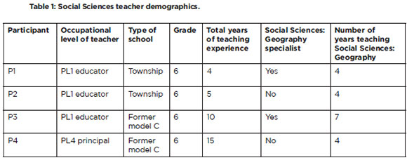
The sample comprised four primary schools in Gauteng. The selection included two township schools and two former Model C suburban schools. Model C refers to former white schools that now admit learners of all races, managed by their governing bodies. These schools typically charge fees and were among the best-resourced and highest-achieving public schools in the country (Christie & McKinney, 2017). Township schools in South Africa are educational institutions situated in townships, areas historically designated for non-white residents during apartheid and were typically under-resourced. This diversity aimed to explore whether the challenges faced by teachers varied based on the school context. One Grade 6 Geography teacher from each school was invited to participate in the study (P1-P4). The years of teaching experience for the different teachers ranged from 4 to 15 years. Table 1 outlines the biographical details of the four participants.
Data collection methods Included semi-structured Interviews and document analysis of teachers' lesson plans for Geography. Thematic analysis was employed to identify and interpret patterns within the qualitative data (Henning et al., 2004). For example, the following excerpt from interviews with teachers: 'Most of us young teachers collaborate/ partner with teachers from other schools for assistance' was highlighted and coded as 'teacher collaboration.' Similar patterns across codes were clustered into categories and then themes (Creswell, 2009). The reliability of the study was ensured through triangulation across different data sources and participants, as well as by providing a detailed audit trail. Ethics approval was obtained from the Faculty Research Ethics Committee at the University of Johannesburg (Sem-1-2021-085). Additionally, permission was granted by the Department of Education and school principals, and consent was obtained from research participants. The findings from the following two themes are reported using examples from various codes and categories to substantiate the results (Miles & Huberman, 1994).
In the next section, data will be presented with LP referring to lesson plans and I to interviews. Each reference will be followed by the corresponding lesson plan or interview number, along with the page and line numbers for easy traceability in audit trails.
RESULTS
Theme 7: Transforming Abstract Map Concepts into Real-World Understanding: Challenges and opportunities
Participants generally believed that learners struggled with abstract map concepts such as latitude, longitude, scale, and hemispheres. Examples from the lesson plan data confirmed that learning activities require abstract thinking, as learners need to consider concepts or ideas that are not physically present (Johnson, 2002). For instance, learners are asked to:
Name the two main lines of latitude and longitude and their measurement in degrees (LP1/p1, L9-10).
Explain how maps are able to represent reality accurately even though they are a smaller representation of reality (LP3/p3, L12).
Participant 2 noted that learners often have misconceptions about latitude and longitude (I2/p2, L47). Similarly, Participant 4 pointed out that learners misunderstand the northern and southern hemispheres and face difficulties identifying latitude and longitude on maps, as well as grasping the concept of scale. For example, participant 4 responded that 'getting learners to understand the difference between latitude and longitude, always confuses them' (I4/P4, L45). Another participant said: 'The first challenge is mixing the two and not getting the correct points when calculating the degrees' (I3/p3, L84). These concepts require learners to think beyond what is perceptible through physical senses, posing a significant challenge (Uttal & Cohen, 2012). This is particularly concerning as these concepts constitute approximately 80% of the mapwork curriculum (DBE, 2011).
A lack of understanding caused learners to struggle with expressing abstract concepts In written language (I2/p2, L48), resulting In a lack of confidence to work on their own (Buehl, 2017). Participants acknowledge that:
When you bring in something that they now have to do after explaining, you find that they are not confident enough to work on their own (l2/p2, L51).
Learners struggle to relate what is shown on the map and the concepts that they are taught (I1/p1, L44).
Learners are used to speaking about a map and not shown a map; when you show them, it becomes difficult for them to relate or interpret the map because they do not understand what is happening. you do explain, but most of them only catch up later (I1/p1, L43-44). However, one participant indicated that 'learners who are more mathematically inclined, more left-brain kids, engage a lot more' (I4, p4, L32). Teachers also recognise the importance of teaching abstract map concepts. For example, participant 4 indicated that when learners understand abstract concepts, it 'takes learners to places they have never seen' (I4/p4, L25).
Participants reported on the strategies that they use to overcome challenges in learning abstract concepts in map skills. Examples include:
We try code-switching and relate the content taught to real-life experiences and we also go outside more especially if we are dealing with distance to make them understand a bit better (I2/p2, L61).
Code-switching refers to alternating between two or more languages during communication, typically the speaker's home language and a second language. Code-switching helps learners understand content, improves class participation, aids communication, fulfils pedagogical purposes, and simplifies explanations of abstract concepts. However, the findings indicate that teachers from the township and former model C suburban schools face similar challenges in code-switching map concepts due to the limited geographical vocabulary in many African languages (Maduane, 2016). The following excerpts from the interview explain this further:
Language is a barrier, firstly, the English language is a barrier as a whole, so you can imagine having specific concepts for that particular subject now it becomes even more confusing (12/p2, L55-56).
Another participant noted that concepts used in map literacy skills are not commonly applied in everyday life (I3/p3, L48). This suggests that map concepts learned in school may be disconnected from real-world experiences, raising concerns about the effectiveness of teaching map skills. Servedio et al. (2009) argue that reinforcing school-taught concepts helps learners better understand them. However, this becomes challenging when learners cannot relate to the concepts due to the lack of equivalent terms in African languages. Participant 2 highlighted this issue, stating, 'it becomes difficult to teach abstract concepts, and you cannot even code switch latitude or even equator' (12/p2, L59). This is particularly problematic as it implies that teachers may struggle to meet lesson objectives, leading to poor performance in assessments that test map literacy skills.
Despite these challenges, Participant 1 indicated that she reinforces concepts taught by giving learners work to do at home (I1/p1, L48). Participant 2 felt that map skills should be scaffolded from grade R and it must be done throughout the year, not only per term as the department stipulates (I2/p2, L77). In attempting to make abstract concepts more realistic, participants reported on the importance of visual aids, best captured by the following excerpt:
Teachers must be provided with visual aids, all learners have textbooks but if you can bring in audio and so forth to explain to learners. It will definitely assist in improving map skills (I4, p4, L35).
I use the globe and a few maps (I1/p1, L50).
However, the issue of limited resources was also flagged: 'I use the textbook and worksheets as I have limited resources' (I2/p2, L63-64). As such, teaching and learning are compromised as 'they do not engage a lot because they do not understand and even us as teachers, we do not have enough resources to teach them' (I1/p1, L26).
Participant 1 elaborated on the difficulties experienced:
We do not have maps in our classrooms, even on the wall (I1/p1, L27). We use maps from the textbook and the textbook does not provide a lot of information for learners to engage with (I1/p1,28).
A lack of resources raises concerns about how teachers help learners understand and engage with map concepts. Conversely, Participants 3 and 4 indicated using atlases, maps, and YouTube videos as teaching resources (I3/p3, L60-61; I4/p4, L37). Lesson plan data also showed that these participants (3 and 4) mentioned using atlases and websites as teaching resources (LP3/p3, L17; LP4/p3, L15).
Another strategy identified as beneficial to teaching map concepts is linking them to real-life experiences and the local context (Naxweka & Wilmot, 2019). From the lesson plan data, teachers' lesson plans do not always link to real-life experiences and local contexts. The following excerpt demonstrates this:
Explain using South Africa by demonstrating its position in the Southern and Eastern hemispheres (LP1/p1, L8).
However, Participant 3 plans lessons that relate to the learner's local context. In her lesson plan, she indicated that she would 'introduce a topic to learners by placing a world map with a specific scale on it and a street map of the area in which the learner's school is situated' (LP3/p3, L2). This indicated that the participant teaches using an example that learners are familiar with. Furthermore, she also instructed learners to 'try to give the location of the city in which their school is situated using the lines of latitude and longitude' (LP3/p3, L15). It should be noted that Participant 3 is also a teacher who specialised in Geography. The data indicate that some teachers can plan lessons linking to real-life or local examples while others struggle. If this is not done, 'there's no link between theory and visual aids' (I1/p1, L42). The result is that learners struggle to understand the terminology associated with map skills as they cannot visualise the concept (I3/p3, L49). Another example of bringing abstract concepts to life is through excursions. Learners learn or acquire new Information through experiential activities such as fieldwork, and practical activities in the classroom or outdoors (Servedio et al., 2009; Ramsaroop, 2018). An example from the data demonstrates how fieldwork is used:
I think as a school we also try and engage in excursions that also speak to Geography, like some of the kids will be off to Sterkfontein caves and Maropeng area which tap into a bit of archaeology which is also geographical and speaks to some elements of map skills in grade 5 and 6 (l3/p3, L80).
Theme 2: The Interplay of Pedagogical Content Knowledge, Time, and Professional Development in teaching map skills
The data suggest that varying levels of teachers' pedagogical content knowledge (PCK), combined with time constraints and ongoing professional development, impact how map skills are taught. The challenges expressed by teachers depend mainly on the type of school, the number of years teaching Social Sciences, and whether the teacher is a Geography specialist. From the demographic data, three participants have 4 years of experience while one teacher has 7 years. Two teachers are Social Sciences specialists and the other two did not major in Social Sciences during their undergraduate degree programmes. These experiences and qualifications impacted on their approach to teaching Geography as follows:
There's always one discipline that will lack if you are teaching both History and Geography (I2/p2, L81).
The passion or even the understanding of the teacher in each subject influences how the content will be delivered to learners. For example, if I am a History person, it means learners Geography will get affected (I2/p2, L82).
Geography, unfortunately, is maybe just not an appraised (valued) subject (13/p3, L 51).
The participants teach both the history and geography components in social sciences, even if they are not specialists in one of the two areas. Most teachers who teach Geography and History prefer one subject over the other, which has a direct impact on the performance of learners as the teacher puts more effort into the discipline that they are most passionate about (Adeyemi, 2009). As such, teachers' poor PCK could also be a factor for why they find it challenging to teach these map skills as they may not have mastered the conceptual depth and scientific nuances of these ideas they are expected to teach (Reitano & Harte, 2016).
Poor content knowledge is linked to the choice of pedagogies used. Here, using traditional teaching methods was prominent in the data in teaching map literacy skills. Traditional methods of teaching follow a teacher-centered approach with minimal learner engagement to elicit their thinking and understanding (Kuzu, 2007). From the lesson plan data, teachers plan their lessons in a manner that places the responsibility for teaching and learning mainly on the teacher (Boumová, 2008). The following excerpts report on the observations made in lesson plans.
Introduce a topic to learners by showing them a globe of the world and ask questions (LP1/p1, L5).
Introduce a topic to learners by placing a world map or regional map indicating a word scale and a line scale on the board (LP4/p4, L7). Explain that the main line of latitude is the equator, which represents 0 degrees. It divides the Earth into Northern and Southern (point these out on the globe) (LP1/p1, L7).
The learning activities require learners to answer questions by referring to a map, but they are limited to classroom experiences and do not encourage incorporating different life experiences. Additionally, the activities are not relatable for learners as they involve places outside South Africa.
Teaching learners to think spatially while using traditional methods of teaching (Scrivener, 2005), which require teachers to spend a lot of time explaining and instructing learners to copy from the board, limits learners' ability to develop spatial thinking skills. Evidence from the lesson plan data exemplifies this: Write the following questions on the board for learners to complete using the globe on display or their atlas' (LP1/p1, L8). Another example from the learner activity is requesting learners to draw the map of the world showing the hemispheres (LA1/p1, p1). Although teachers identified time constraints as a challenge, the data indicated that teachers are not utilising instruction time effectively. The purpose of a learning activity is to determine if learners understand the key concepts taught (Rapanta et al., 2020). However, data confirms one of the teachers instructing learners to draw a map. The learning outcome for this lesson states that 'learners should identify and extract information from texts, atlases and other sources including visual sources such as photographs' (DBE, 2011, p.14). It does not make sense to give learners an activity that requires a lot of time and that does not meet the outcomes of the lesson. Moreover, teachers expressed the view that more time was needed to teach map literacy skills: 'Geography is literally something that comes up for an hour at most a week (I3/p3, L49). In line with this, Participant 3 mentions that 'when we look at the time allocation for both subjects it is not conducive to teach learners all the map skills' (I2/p2, L80).
In some instances, teachers find themselves lagging behind with the curriculum delivery as they must constantly go back and make sure learners understand. For example, Participant 1 indicated that 'we can teach one topic for a week because I have to go back and explain again and go back and explain again because some of them do not understand' (I1/p1, L31). Therefore, selecting activities that do not utilise learning time optimally is puzzling. However, it could relate to teachers' over-reliance on activities in the prescribed textbooks with limited thought on how they link to their specific contexts. Many schools spend over a third of their budget on textbooks (Wills & Hofmeyr, 2019), which could indirectly be sending a message to teachers that they must maximise their use of them in their teaching.
Successful teaching and learning occur when there is ongoing teacher support and professional development from different stakeholders (Chen, 2020). In this study, teachers highlighted support from different stakeholders as a challenge. Participant 1 indicated that young teachers collaborate and partner with teachers from other schools for assistance (I1/p1, L62) because there is no support received from their own school management team. Excerpts from the interview data reveal this: 'there is no support even from the HOD, every man for himself (I1/p1, L60). This teacher uses her own agency to recognise the gap that she has in her own learning and seeks help from teachers in neighbouring schools. One of the reasons for little support from the school management team could be related to having a Head of Department that lacks the relevant content knowledge in Social Sciences, specifically map skills, to provide adequate leadership in this area. Such a view is supported by the following statement made by one of the teachers: 'our Departmental Head knows nothing about Social Sciences, Geography' (I2/ p2, L73).
Participant 1 also indicated that when support is received from the Department of Education it is normally in the form of online workshops, which is inadequate. Sipilä et al. (2021, p.1232) mention that 'effective learning and teaching incorporate bodily, physical and social aspects which are hard to establish in online sessions.' Furthermore, through online learning, it is difficult to learn practical skills which is essential in the understanding of abstract concepts (Sipila et al., 2021). Similarly, Participant 1 felt it will be better if the workshops are physical so they can be able to engage and ask questions (I1/p1, L57-59). On the other hand, participants provided positive insights about the support received from different stakeholders. This is revealed in the following excerpts:
The support I receive from our facilitator is amazing (I2/p2, L71).
He offers workshops, we also enroll at the University of Johannesburg for short courses, and he is always there to assist, even today he told us to come to him should we want resources (I2/p2, L72).
The department in the past had workshops for map work specifically and they have also launched some courses where you can register to improve map skills and to develop teachers (I4/p4, L41).
The GDE does provide workshops on map skills, it does try to even offer teachers an opportunity to go and study a short course based on map skills at UJ (I3/p3, L68).
Our management has also tried to provide extra resources to help learners (I3/p3, L70).
DISCUSSION
Connecting learners' everyday experiences to classroom concepts is crucial for meaningful learning. Teachers' spatial anxiety can hinder learners' spatial development, as less confident teachers may avoid strategies like sketching or gestures. Introducing big ideas in Geography, such as time, space, and place, from a young age helps develop spatial thinking skills (Choi et al., 2010; Gunderson et al., 2013; Gagnier & Fisher, 2020). Based on the data, the primary challenge in teaching abstract map skills is that only two out of the four participants were qualified to teach Geography at the intermediate phase. Teachers assigned to subjects outside their expertise are known as out-of-field teachers (Caldis & Kleeman, 2019), a situation often encountered in the early years of teaching. One of the Social Sciences teachers, who is not a specialist, is in her fifth year of teaching, while the other has fifteen years of experience. Despite their overall teaching experience, both have only been teaching Geography for the past four years, making them novice teachers in this subject. Research by Caldis & Kleeman (2019) indicates that teaching quality declines when teachers are not specialists in their field, leading to increased anxiety and a lack of confidence in teaching the subject. Effective teaching requires a combination of subject content knowledge and pedagogical content knowledge (Weldon, 2016), which allows teachers to incorporate real-life examples, making learning relevant and meaningful.
The teachers highlighted several challenges. The activity system is defined as people who share a common object and a range of tools that they can use together to assist in improving the object (Wilson, 2014). The tools, subject, and object have a dialectical relationship that can influence one another as well as the overall activity (Stetsenko, 2005). In this respect, the second challenge identified by the subjects relates to the tools and instruments available (maps, globe, textbooks). The tools, such as resources, teachers' lesson plans, and map language, are central to the relationship between the subject and the object of improving learners' understanding of map skills. The data confirms that these tools can either constrain or enable action. The community, including the departmental head, principal, deputy principal, and the Department of Education, is not adequately supporting teachers by providing the necessary tools for effective teaching. This lack of support highlights a deficiency in the division of labour among the different role players. The principle of multi-voicedness (Engeström, 2001) from CHAT is relevant here, as different participants bring their own histories and perspectives, which ultimately impact the division of labour. Foot (2014) argues that cultural values and resources shape people's actions. The data suggest that traditional methods used by teachers are influenced by how they were taught as learners or during their teacher training. Similarly, a passion for a particular discipline may be culturally rooted based on how it was taught. This results in contradictions between the subject, object, and outcome. The resources and artefacts are also entrenched in their history, stemming from the years of apartheid and the unequal distribution of resources (McKay, 2019; Thaba-Nkadimene, 2020). Teachers' lack of resources may have led them to revert to traditional or outdated teaching methods, thus compromising the objective of the activity system, which is the children's learning of key concepts.
The third challenge is teachers' reliance on traditional methods for teaching map skills, which can hinder learning. Although aware of learners' challenges, teachers rarely reflect on their practices. CHAT principles suggest that learning is embedded in social contexts, where collaboration and engagement with artefacts help teachers reflect on their methods (Hoffman-Kipp et al., 2003). However, limited engagement with tools and the community restricts meaningful reflection. Wilmot & Irwin (2015) argue that teachers' struggles to integrate learners' life experiences into teaching make it difficult for learners to connect abstract geographical concepts with prior knowledge. Inadequate teaching methods also impact children's spatial development, which varies based on background, developmental stage, and social context (Havelkova & Hanus, 2019). Davis (2015) further argues that when children understand concepts, they soon start to connect this reasoning to their encounters with conventional images in books, on screens, in toys, or in real-life experiences.
The next challenge elucidated from the data is that the subjects in this research, namely teachers, struggle with teaching all the map concepts due to time constraints. This results in tensions between the subject, the mediating artefact (lesson plan) and the rules in the system. The rules pertaining to time constraints are included in the CAPS policy (DBE, 2011). The CAPS document clearly stipulates the time teachers should spend on a certain topic and it also highlights the objectives of that particular lesson. It is clear from the data that tensions arise when the actual enactment of the lesson falls short of what was expected to have been achieved from the lesson plan, resulting in a gap between what was planned and what was achieved. The challenge arises when teachers struggle to reach the objectives set by policy, which in turn influence the object and the outcome. This finding is not new, with previous research corroborating the view that the time allocated to teach the various sections in the Social Science curriculum was insufficient for learners to grasp key concepts (Wilmot & Irwin, 2015; Niyazi, 2018). This means teachers do not have enough time to address misconceptions that learners might have. Naidoo (2019) argues that teachers experience difficulty keeping up with the prescribed time as they need to constantly consider learner diversity and the difficulties that come with planning a lesson that can accommodate all learners. In some instances, the classes are overcrowded, and teachers struggle to cater to the different learning needs, which further impacts time (Naidoo, 2019). A lack of knowledge of pedagogical content in planning lessons is also a factor. For example, expecting learners to redraw a map from a textbook is time-consuming. Instead, using the local context would have been more valuable, such as asking learners to draw a map of walking from home to school or within the school premises as it would strengthen spatial thinking.
Linked to limited time-frames, teachers often express frustration at repeating content due to learners' gaps in prior knowledge. Learners may advance from one grade to the next with incomplete knowledge, requiring teachers to spend extra time connecting new learnings. The curriculum aims for incremental understanding of map concepts, but learners struggle to transfer knowledge. This necessitates reteaching, which exceeds the allocated time in the CAPS. CAPS allocates 15 hours per year for Grade 6 map skills, with specific times for each topic, such as four hours for latitude and longitude. Social Sciences have a weekly three-hour allocation, with 1.5 hours for Geography. This limited time makes it challenging to address misconceptions or explain abstract concepts like latitude, longitude, and scale (Wilmot & Irwin, 2015; Niyazi, 2018). Finally, the subjects attempt to teach in a manner that is meaningful to learners, but contradictions arise between the subject and tools, particularly with the unique language of map literacy skills. Effective strategies require collaboration across the entire activity system. For instance, scaffolding map concepts from Grade R necessitates the Department of Education's support to develop spatial thinking from a young age. Teachers also need more support to foster this development. Some teachers, recognising the lack of support, reached out to peers in neighbouring schools to learn from each other. These contradictions, while problematic, drive change and expansive learning, leading to collective and distributed agency (Engeström & Sannino, 2017). Teachers used their agency to seek solutions, addressing challenges proactively. This reconceptualises the activity system's object, envisioning new possibilities (Engeström, 2001). Contradictions thus serve as stimuli for growth, highlighting the importance of the entire system working together to improve children's map skills learning.
CONCLUSIONS
The primary aim of this study was to explore the experiences of teachers when teaching map skills to Grade 6 learners. The findings highlighted the challenges and opportunities in transforming abstract map concepts into real-world understanding. Varying levels of teachers' pedagogical content knowledge, time constraints, and ongoing professional development impact how map skills are taught. The interrelated elements in cultural-historical activity theory (CHAT) were useful in highlighting interactions and contradictions (Engeström, 2001). Contradictions arose between the subject and the community due to weak relationships, minimal collaboration, and poor communication about the division of labour. CHAT effectively highlighted these contradictions, which drive growth and expanded learning opportunities. Teacher agency was crucial for growth and change, as teachers recognised their learning gaps and sought support from their network. From a CHAT perspective, the entire system must work together to achieve desired outcomes. Each community member must understand their roles and responsibilities, share the division of labour, and observe system rules. This collaborative approach can contribute towards improving children's learning in map skills.
REFERENCES
Adeyemi, B. (2009). Students' self concept, attitude and achievement in social studies in junior secondary schools in southwestern Nigeria. ICERI2009 Proceedings, 2nd International Conference of Education, Research and Innovation, Madrid, Spain, 16-18 November, 2009, pp. 4087-4094.
Ahiaku, P. K. A., Mncube, D. W., & Olaniran, S. O. (2019). Teaching map work in South African schools: reflections from teachers' experiences, concerns and challenges. Journal of Gender, Information and Development in Africa (JGIDA), 8(2), 19-36. [ Links ]
Amosun, P. A. (2016). Why Nigerian Geography Teachers Scarcely and Scantly Teach Map Reading and Why Students Are Scared of It. African Educational Research Journal, 4(2), 42-48. [ Links ]
Anderson, T. (2003). Getting the mix right again: An updated and theoretical rationale for interaction. The International Review of Research in Open and Distributed Learning, 4(2), 3-6. [ Links ]
Bednarz, R. S., & Bednarz, S. W. (2008). The importance of spatial thinking in an uncertain world. In: Sui, D. Z. (ed), Geospatial Technologies and Homeland Security, pp. 315-330. Springer, Dordrecht.
Bednarz, S. W., Jo, I., & Shin, E. (2022). Spatial thinking in primary geography. In: Kidman, G., & Schmeinck, D. (eds), Teaching Primary Geography, pp. 133-144. Springer, Cham.
Boumová, V. (2008). Traditional vs. modern teaching methods: Advantages and disadvantages of each. Unpublished PhD dissertation, Masarykova Univerzita. [ Links ]
Buehl, D. (2017). Classroom strategies for interactive learning. Routledge, New York.
Caldis, S., & Kleeman, G. (2019). Geography and STEM. Geographical Education (Online), 32, 5-10. [ Links ]
Chen, J. (2020). Teacher emotions in their professional lives: implications for teacher development. Asia-Pacific Journal of Teacher Education, 48(5), 491-507. [ Links ]
Choi, S., Niyogi, D., Shepardson, D. P., & Charusombat, U. (2010). Do earth and environmental science textbooks promote middle and high school students' conceptual development about climate change: textbooks consideration of student's misconceptions? Bulletin of the American Meteorological Society, 91(7), 889-898. [ Links ]
Christie, P., & McKinney, C. (2017). Decoloniality and 'Model C' schools: Ethos, language and the protests of 2016. Education as Change, 21(3), 1-21. [ Links ]
Clements, D. H. (2004). Geometric and spatial thinking in early childhood education Engaging young children in mathematics: Standards for early childhood mathematics education. In: Clements, D. H., & Sarama, J. (eds), Engaging young children in mathematics: Standards for early childhood mathematics education, pp. 267-297. Lawrence Erlbaum Associates Mahwah, New Jersey.
Creswell, J. W. (2009). Research Design: Qualitative, Quantitative, and Mixed Methods Approaches, 3rd Edition. Sage, Thousand Oaks.
Davis, B. (2015). Spatial Reasoning in the Early Years. Routledge, London.
Department of Basic Education (DBE) (2011). National Curriculum Statement. Curriculum and Assessment Policy Statement (CAPS). Social Science Intermediate Phase Grades 4-7. DBE, Pretoria.
Duarte, R. G. (2021). Geography Textbooks in Brazil and the Development of Spatial Thinking in School Students Using Maps and Images. In: Vanzella Castellar, S. M., Garrido-Pereira, M., & Moreno Lache, N. (eds), Geographical Reasoning and Learning, pp. 247-267. Springer, Cham.
Engeström, Y. (1987) Learning by Expanding: an activity-theoretical approach to developmental research. Orienta-Konsultit, Helsinki.
Engeström, Y. (2001). Expansive learning at work: Toward an activity theoretical reconceptualisation. Journal of Education and Work, 14(1), 133-156. [ Links ]
Engeström, Y., & Sannino, A. (2017). Studies of expansive learning: Foundations, findings and future challenges. In: Daniels, H. (ed), Introduction to Vygotsky, pp. 100-146. Prentice-Hall, New Jersey.
Foot, K. A. (2014). Cultural-historical activity theory: Exploring a theory to inform practice and research. Journal of Human Behavior in the Social Environment, 24(3), 329-347. [ Links ]
Gagnier, K. M., & Fisher, K. R. (2020). Unpacking the black box of translation: A framework for infusing spatial thinking into curricula. Cognitive Research: Principles and Implications, 5(1), 1-19. [ Links ]
Gagnier, K. M., Holochwost, S. J., & Fisher, K. R. (2022). Spatial thinking in science, technology, engineering, and mathematics: Elementary teachers' beliefs, perceptions, and self-efficacy. Journal of Research in Science Teaching, 59(1), 95-126. [ Links ]
Garreau, L., Mouricou, P., & Grimand, A. (2015). Drawing on the map: An exploration of strategic sensemaking/giving practices using visual representations. British Journal of Management, 26(4), 689-712. [ Links ]
Gersmehl, P. J., & Gersmehl, C. A. (2007). Spatial thinking by young children: Neurologic evidence for early development and 'educability'. Journal of Geography, 106(5), 181-191. [ Links ]
Gökçe, N. (2015). Social studies in improving students' map skills: Teachers' opinions. Educational Sciences: Theory & Practice, 15(5), 1346-1360. [ Links ]
Gunderson, E. A., Ramirez, G., Beilock, S. L., & Levine, S. C. (2013). Teachers' spatial anxiety relates to 1st-and 2nd-graders' spatial learning. Mind, Brain, and Education, 7(3), 196-199. [ Links ]
Havelkova, L., & Hanus, M. (2019). Map skills in education: A systematic review of terminology, methodology, and influencing factors. Review ofInternational Geographical Education Online, 9(2), 361-401. [ Links ]
Hawes, Z., Tepylo, D., & Moss, J. (2015). Developing spatial thinking. In: Davis, B. (ed), Spatial Reasoning in the Early Years, pp. 39-54. Routledge, London.
Henning, E., Van Rensburg, W., & Smit, B. (2004). Finding your way in Qualitative Research. Van Schaik, Pretoria.
Hoffman-Kipp, P., Artiles, A., & López-Torres, L. (2003). Beyond Reflection: Teacher learning as Praxis. Theory and Practice, 42(3), 248-254. [ Links ]
Jamshidpour, N., Homayouni, S., & Safari, A. (2016). Graph-based semi-supervised hyperspectral image classification using spatial information. 2016 8th Workshop on Hyperspectral Image and Signal Processing: Evolution in Remote Sensing (WHISPERS), pp. 1-4.
Johnson, F. (2002). Measuring Outcomes of Students' Learning Involving the Learning Modalities, Domains, Critical Thinking Skills Levels, and Right-and Left-Brain Thinking. Tenth Annual Symposium on Teaching Effectiveness, pp. 18-38.
Karaca, A., & Yalcinkaya, E. (2021). Examination of Studies Aimed at Developing Map Skills in Secondary School Students: A Meta-Analysis. Review of International Geographical Education Online, 11(1), 236-261. [ Links ]
Kuzu, A. (2007). Views of preservice teachers on blog use for instruction and social interaction. Turkish Online Journal of Distance Education, 8(3), 34-51 [ Links ]
Krygier, J., & Wood, D. (2016). Making maps: a visual guide to map design for GIS. Guilford Publications, London.
Larangeira, R., & van der Merwe, C. D. (2016). Map Literacy and Spatial Cognition Challenges for Student Geography Teachers in South Africa. Perspective in Education, 34(2), 120-138. [ Links ]
Logan, J. R. (2012). Making a place for space: Spatial thinking in social science. Annual Review of Sociology, 38, 507-524. [ Links ]
Maduane, L. H. (2016). Barriers to geography learning and teaching in grade 12 in the Limpopo Province. Unpublished PhD thesis, University of Limpopo. [ Links ]
McKay, T. (2019). The geography of education: From race to class apartheid? In: Knight, J., & Rogerson, C. M. (eds), The Geography of South Africa, pp. 159-167. Springer, Cham.
Merriam, S. B. (1998) Qualitative Research and Case Study Applications in Education. Jossey-Bass Publishers, San Francisco.
Metoyer, S. K., Bednarz, S. W., & Bednarz, R. S. (2015). Spatial thinking in education: Concepts, development, and assessment. In: Solari, O. M., Demirci, A., & Schee, J. (eds), Geospatial Technologies and Geography Education in a Changing World, pp. 21-33. Springer, Tokyo.
Miles, M. B., & Huberman, A. M. (1994). Qualitative data analysis: An expanded sourcebook. Sage, California.
Naidoo, P. (2019). Perceptions of teachers and school management teams of the leadership roles of public school principals. South African Journal of Education, 39(2), 1534. https://doi.org/10.15700/saje.v39n2a1534. [ Links ]
National Research Council (NRC) (2005). Learning to Think Spatially. National Academies Press, Washington DC.
Naxweka, J., & Wilmot, D. (2019). Namibian teachers' perceptions and practices of teaching mapwork. Journal of Geography Education in Africa, 2, 1-14. [ Links ]
Newcombe, N. S. (2013). Seeing Relationships: Using Spatial Thinking to Teach Science, Mathematics, and Social Studies. American Educator, 37(1), 26-31. [ Links ]
Niyazi, K. (2018). Main challenges in front of the teachers to teach geography more effectively: A phenomenological research. Review of International Geographical Education Online, 8(2), 371-393. [ Links ]
Ooms, K., De Maeyer, P., Dupont, L., Van der Veken, N., Van de Weghe, N., & Verplaetse, S. (2016). Education in cartography: what is the status of young people's map-reading skills? Cartography and Geographic Information Science, 43(2), 134-153. [ Links ]
Platas, L. M. (2017). Three for one: Supporting social, emotional, and mathematical development. YC Young Children, 72(1), 33-37. [ Links ]
Ramsaroop, S. (2018). Bringing Map Learning to 'Life' by Using the Environment as a Learning Resource. Alternation Journal, 21, 109-130. [ Links ]
Rapanta, C., Botturi, L., Goodyear, P., Guàrdia, L., & Koole, M. (2020). Online university teaching during and after the Covid-19 crisis: Refocusing teacher presence and learning activity. Postdigital Science and Education, 2(3), 923-945. [ Links ]
Reitano, P., & Harte, W. (2016). Geography pre-service teachers' pedagogical content knowledge. Pedagogies: An International Journal, 11(4), 279-291. [ Links ]
Scrivener, J. (2005). Learning Teaching. Macmillan, Oxford.
Servedio, M. R., Saether, S. A., & Saetre, G. P. (2009). Reinforcement and learning. Evolutionary Ecology, 23(1), 109-123. [ Links ]
Sipilä, E., Elo, C., Rauhala, E. L., Ihalainen, T., & Virkki, J. (2021). Rapid switch from face-to-face workshops to online workshops. SEFI 49'h Annual Conference, Berlin, pp. 1250-1257.
Stetsenko, A. (2005). Activity as object-related: Resolving the dichotomy of individual and collective planes of activity. Mind, Culture, and Activity, 12(1), 70-88. [ Links ]
Thaba-Nkadimene, K. L. (2020). The influence of educational provision on teacher performance and learner outcomes among Limpopo primary schools. South African Journal of Education, 40(4), 2039. https://doi.org/10.15700/saje.v40n4a2039 [ Links ]
Tshibalo, A. E. (2003). Cooperative learning as a strategy to improve the teaching of mapwork to grade 11 and 12 Geography learners in Region 3 (Limpopo Province): a case study conducted at Ramaano Mbulaheni Inservice Training Centre. Proceedings of the 21st International Cartographic Conference (ICC) "Cartographic Renaissance", Durban, South Africa, pp. 2555-2559.
Uttal, D. H. (2000). Seeing the big picture: Map use and the development of spatial cognition. Developmental Science, 3(3), 247-264. [ Links ]
Uttal, D. H., & Cohen, C. A. (2012). Spatial thinking and STEM education: When, why, and how? Psychology of Learning and Motivation, 57, 147-181. [ Links ]
Weldon, P. R. (2016). Out-of-field Teaching in Australian Secondary Schools. Policy Insights, 6, 1-17. [ Links ]
Whiteley, W., Sinclair, N., & Davis, B. (2015). What is spatial reasoning? In: Davis, B. (ed), Spatial Reasoning in the Early Years, pp. 13-24. Routledge, London.
Wiegand, P. (2006). Learning and Teaching with Maps. Routledge, New York.
Wills, G., & Hofmeyr, H. (2019). Academic resilience in challenging contexts: Evidence from township and rural primary schools in South Africa. International Journal of Educational Research, 98, 192-205. [ Links ]
Wilmot, P. D. (1999). Graphicacy as a Form of Communication. South African Geographical Journal, 81(2), 91-95. [ Links ]
Wilmot, D. (2002). Investigating children's graphic skills: A South African case study. International Research in Geographical and Environmental Education, 11(4), 325-340. [ Links ]
Wilmot, D., & Irwin, P. (2015). South African Teachers' Perceptions of the Primary Geography Curriculum: An Exploratory Study. Review of International Geographical Education Online, 5(2), 137-150. [ Links ]
Wilson, E. (2014). Diversity, culture and the glass ceiling. Journal of Cultural Diversity, 21(3), 83-89. [ Links ]
Yamagata-Lynch, L. C. (2010). Activity Systems Analysis Methods: Understanding Complex Learning Environments. Springer Science & Business Media, New York.
Received 24 September 2024
Accepted 8 December 2024
Published 30 December 2024
