


Services on Demand
Journal

Article
 English (pdf)
 Article in xml format
 Article references
 Send this article by e-mail
Indicators
Related links
-
 Cited by Google
 -
 Similars in Google
Share

 Permalink
Southern African Field Archaeology
On-line version ISSN 2789-1844Print version ISSN 1019-5785
South. Afr. Field Archaeol. vol.20 Johannesburg 2025
https://doi.org/10.36615/safa.20.3028.2025
PEER-REVIEWED RESEARCH REPORT
Granite spalling as a proxy of climate change during the late Pleistocene and early Holocene at Pomongwe Cave, Matobo World Heritage Landscape
Thubelihle R. MnkandlaI, ; Ancila NhamoI, II
IDepartment of History, Heritage and Knowledge Systems, University of Zimbabwe, P.O. Box MP 167, Mount Pleasant, Zimbabwe
IIResearch Innovation and Industrialisation Directorate, University of Zimbabwe, P.O. Box MP 167, Mount Pleasant, Zimbabwe
ABSTRACT
There is limited palaeoenvironmental data on Zimbabwe, primarily because the usual proxies used for climatic reconstructions are rarely preserved in the Zimbabwean archaeological record. Against this background, this research seeks to assess the practicality of using granite spalls that occur in the archaeological record as signatures of past climatic changes. We hypothesise that the size of spalls and the rate of exfoliation are dependent upon climatic conditions such as temperature and precipitation. We apply this principle by analysing the size and concentration of granite spalls within the stratigraphy of Pomongwe Cave, to reconstruct the palaeoclimatic conditions that prevailed during its occupation. Our results indicate that the environmental conditions changed through time, and this is reflected by the occurrence of granite spalls of varying sizes and concentrations. However, the results in this paper present a proof of concept that requires further investigation.
Keywords: Pomongwe, palaeoenvironments, granite spalls, geoarchaeology
1. Introduction
Climatic changes were experienced globally during the shift from the late Pleistocene to the early Holocene, significantly impacting the behaviour of early modern humans. These climatic changes are believed to have played a critical role in human history. Climate changes had implications for the development of modern human behaviour, the expansion of human populations, and their dispersal (Potts 1998; Mellars 2006; Backwell et. al. 2014). Furthermore, the climatic changes that prevailed during the terminal Pleistocene to early Holocene resulted in the development of various tool technocomplexes (Robinson 2023). Unfortunately, in Africa in general and Zimbabwe in particular, limited studies on palaeoenvironmental reconstructions have been conducted to contextualise these dynamics. The limited studies are to some extent a result of a lack of interest and expertise in the area, but the major impediment is the difficulty in finding signatures of climate change in the archaeological record. In other parts of southern Africa, substantial data have been recorded in stalagmites and stalactites from caves, especially limestone caves (Holzkämper et al. 2009; Braun et al. 2019). Unfortunately, these are not commonly found in association with Stone Age sites in Zimbabwe because of the predominance of granite landforms in the country. This dearth in palaeoenvironmental proxies coupled with the abundance of granite has led us to explore whether the use of granite spalls, that are ubiquitous at terminal Pleistocene/early Holocene sites, can be used as proxy data for the reconstruction of palaeoenvironmental conditions. In this regard, we use Pomongwe Cave as the case study in this research.
The site of Pomongwe in the Matobo UNESCO World Heritage Landscape has cultural material that dates from the terminal late Pleistocene to the terminal Holocene (Nhamo-Katsamudanga & Chiwara-Maenzanise 2023). Pomongwe has material that dates to >13 000 BP which falls within the terminal late Pleistocene. It has yielded abundant granite spalls incorporated into the stratigraphie layers. However, this is not a unique case, with extensive occurrences of granite spalls having been recorded at other sites of the same period including but not limited to: Tshangula, Nswatugi, Bambata (in the Matobo), Zombepata (northern Zimbabwe), Ruchera (northeastern Zimbabwe), Redcliff (Midlands), and Diana's vow (southeastern Zimbabwe) (Cooke 1963, 1971; Walker 1995). As such, the use of granite spalls, if found viable, would greatly widen the scope of palaeoenvironmental research in Zimbabwe. It would improve the availability of stable and reliable proxy data that would make temporal and spatial inter-site comparisons easier, currently a major shortfall as identified by Katsamudanga and Nhamo (2016), especially for the Stone Age.
2. Background to palaeoclimatic studies in Zimbabwe
Generally, as compared to other components of the past, palaeoenvironments are not well-researched in Zimbabwe, and in general climate proxies most commonly used in palaeoenvironmental research are lacking (Walker 1995; Katsamudanga & Nhamo 2016). The first attempts to reconstruct palaeoenvironments in Zimbabwe explored the use of geomorphological processes for this purpose. Bond (1949, 1957) was the main proponent of this approach. He made concerted efforts to reconstruct palaeoclimates based on physical evidence of erosional and depositional processes, i.e., based on signatures of pluvial and fluvial processes. The size and distribution of pebbles in riverbeds were used to estimate precipitation levels, with larger pebbles seen to indicate higher river discharge during wet periods (Bond 1964). These pluvial studies enabled Bond (1949, 1957, 1964, 1965) to estimate the changes in temperature and precipitation within particular periods. For example, he studied pebble sizes to estimate that the Earlier Stone Age (ESA) experienced two wet periods: the first was during the transition from the Oldowan to Acheulean, during the early Pleistocene; the second wet period was identified during the late Acheulean, falling within the middle Pleistocene (Bond 1949). In these studies, while pebble size serves as proxy of the amount of water being discharged by rivers, by extension it can also clarify the amount of precipitation falling during a particular period (Dollar 1998). During the wet periods, the rivers have much more carrying capacity than during the dry periods, therefore they can carry larger pebbles further along the rivers. This kind of evidence was derived from sites along the Zambezi River, such as from the Victoria Falls area, and the Lochard and Khami Waterworks near Bulawayo (Summers 1960; Bond 1964, 1965).
However, the use of fluvial and pluvial processes in reconstructing palaeoenvironmental conditions was not without challenges. The chronometric dating of these processes is challenging, which is why researchers such as Bond relied on relative chronologies based on the type of associated stone tools (Acheulean, Sangoan, etc.). Thus, this research was dependent upon the extent of archaeological research at the time. In addition, as Dollar (1998) observes, the evidence used can be a result of other factors besides climate or environmental change. The evidence is also limited in occurrence to the Zambezi and other fairly large rivers in the country.
In addition to fluvial and pluvial processes, dry periods were detected based on chemical processes in the formation of silcrete, calcrete, and ferricrete deposits on stone tools. These deposits occur under conditions of reduced precipitation of less than 450 mm of rainfall (Bond 1964). Some Acheulean and Sangoan tools that occurred in these deposits were argued to derive from such drier periods (Bond & Clark 1954; Bond 1964). Further geomorphological evidence in the form of aeolian sands was used to reconstruct palaeoenvironments in the Hwange National Park and at Victoria Falls. Evidence of aridity comes from the intensification of dune fields, whereas the erosion of the dune surfaces indicates wet periods (Haynes 1996). Haynes (1996) found evidence of extreme fluctuations between dry and wet periods in the Hwange National Park, especially during the early Middle Stone Age (MSA) between 130-120 kya. The occurrence of the wet periods was supported by sedimentological evidence of ancient lakes, and ponded water in both the Hwange National Park and the neighbouring Makgadikgadi Basin in Botswana (Haynes 1996). Although both the aeolian sands and sedimentological evidence constitute good proxies for palaeoenvironmental changes, their occurrence is as limited as that of the other geomorphological data and, therefore, cannot be relied on to provide extensive data for most parts of Zimbabwe.
Other researchers have inferred palaeoenvironmental conditions from faunal remains. For example, a wetter phase of the Bambata period (MSA) was identified using faunal remains by Brain (1969) and Cruz-Uribe (1983) at the site of Redcliff in the Midlands region of Zimbabwe. Here, the presence of the extinct giant Cape horse (Equus quagga) was used to infer cooler and wetter conditions during the Bambata period (Cruz-Uribe 1983). Although some faunal assemblages from archaeological sites provide insights into vegetation and climate, the signatures are too specific to have broader applications. For example, Cruz-Uribe (1983) found only one animal that is climate-sensitive.
Researchers who have worked on the terminal late Pleistocene and early Holocene have also tried to reconstruct the palaeoenvironment. Walker (1995) came up with a hypothetical model of past environments in the Matobo based primarily upon palaeoclimatic data from southern Africa. This model is discussed in detail elsewhere in the paper, but what is critical to note here is that it relied heavily on evidence from outside Zimbabwe, i.e., from South Africa and Botswana. This scarcity of local palaeoenvironmental proxies led us to consider the use of granite spalls.
In most cases, the size of granite flakes can reveal important clues about the environmental conditions under which they formed or were altered. Large spalls result from slow and less intense weathering processes, such as from freezing and thawing action. On the other hand, small flakes reflect more intense mechanical weathering, such as through exfoliation associated with thermal stress from dry conditions (Anderson & Anderson 2010). However, smaller flakes can also result from chemical weathering which intensifies during wet periods because of elevated moisture content and organic acids (Boggs 2006). Therefore, by studying granite flake sizes in association with other variables such as cultural indicators, we can infer palaeoenvironmental histories of specific regions.
Granite is an excellent rock type for inferring these palaeoenvironmental conditions because of its durability and resistance to weathering, owing to its composition of quartz, feldspar, and mica, making it a reliable recorder of long-term environmental changes (Plummer et al. 2016). Granite also exhibits distinct and predictable weathering patterns, such as exfoliation, block disintegration, and granular disintegration, which are strongly influenced by environmental factors such as temperature, moisture, and biological activity (Migon 2006; Marshak 2019). Exfoliation (spheroidal weathering) occurs when the outer layers of granite expand and contract due to repeated heating and cooling in arid and semi-arid regions. Over time, this causes the outer layers to peel away in curved sheets or shells. Block disintegration occurs when granite breaks into smaller, angular blocks as it separates from the parent rock along pre-existing joints or fractures. Environmental forces, such as freeze-thaw cycles, contribute to this process (Migon 2006; Anderson & Anderson 2010; Marshak 2019). Granular granite disintegration is in most cases a result of chemical weathering, especially in cave environments like those at Pomongwe with heightened humidity and biological activities. In such an environment, minerals such as feldspar and mica react with water through the processes of hydrolysis and oxidation to form clays and iron oxides, leaving quartz behind as loose granules (Ollier 1984; Goudie & Viles 1997). Therefore, all these visible and measurable weathering features can facilitate the analysis and quantification of palaeoenvironmental conditions (Boggs 2006).
Granite is widespread in Zimbabwe (Mugumbate 2013) and much of southern Africa (Twidale 2012). In Zimbabwe, there is an abundance of granite spalls at archaeological sites such as Pomongwe, Bambata, Nswatugi, and Amadzimba (Cooke 1963). Cooke (1971) also found granite spalls at other sites in Zimbabwe, such as at Ruchera and Zombepata in northeast and northwestern Zimbabwe. The potential of finding granite spalls at other Stone Age sites in cave environments elsewhere in Zimbabwe is very high, making the exploration of this ubiquitous material a potentially powerful palaeoenvironmental proxy. Once sufficient methods are established, they can facilitate comparative studies of palaeoenviromental conditions across the country and the region. Therefore, the major aim of this paper is to study the granite spalls found in stratigraphic levels at Pomongwe, and to establish whether they can be used as complimentary proxies of palaeoenvironments in Zimbabwe. Although the use of the spalls in this way has been alluded to by Cooke (1963), there has no systematic study, either in the region or elsewhere globally, that has used spalls to establish past environments. As such, this paper is such an attempt. Sumner et al. (2012) cite several studies that describe the exfoliation of different rock types due to climatic conditions. Although these studies were done mainly in relation to the effects of weathering on rock art, their insights are crucial to our paper.
3. Pomongwe Cave
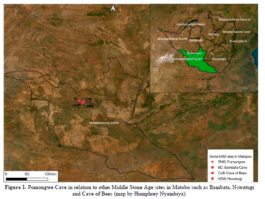
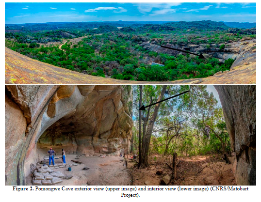
Pomongwe Cave (Fig. 1) is located approximately 34 km from Bulawayo, Zimbabwe's second-largest city. It is located within the boundaries of the Matobo National Park, facing northeast at the end of a small valley. The cave floor is positioned about three metres above the valley floor (Walker 1995). The cave is about 20 by 20 metres, with a ceiling height above bedrock of about 15 metres (Cooke 1963; Walker 1995; Porraz et al. 2023).
Geologically, the Matobo comprises a granite massif that is brownish-grey in colour and consists of medium sand-sized grains (Grout 1935; Pye et al. 1984). The massif is about 2.65 billion years old and it covers 2050 km2 (UNESCO 2003). Other rock pockets found in the Matobo include augen gneisses, older granites, and grandiosities, with additional minor intrusions of quartz and dolerite veins (Walker 1995). Smith (1968) noted that there are two types of quartz veins in the Matobo Cultural Landscape. The first type is the result of fracture infilling and the second occurs as single stringers on veins not related to a fault or a fracture zone (Smith 1968).
The deep caves commonly found in the Matobo granite seem to have formed through negative and spheroidal exfoliation, a process where curved layers of rock are peeled away, creating dome-shaped hills. The spheroidal exfoliation occurs in well-jointed rocks when the water penetrates the joints and attacks the blocks from all sides (Basu & Bandyopadhyay 2014). This process is influenced by flow patterns that were created during the formation of the rock, temperature changes that take advantage of fracture planes, and the natural weaknesses of the rock (Smith 1968; Walker 1995; Broderick & Hubbard 2016). This results in the breaking off of a succession of curved layers that eventually form the caves.
Although there are several other archaeological sites in the Matobo Landscape, the focus of this research is on Pomongwe Cave (Fig. 2) because there is an abundance of well-preserved granite spalls within different stratigraphic levels. This allows us to compare their variation in size and concentration over time, and to assess whether it is possible to reconstruct the palaeoenvironmental conditions. Cooke (1963) excavated three trenches, i.e., I, II, and III, at Pomongwe Cave in the 1960s. Trench I has deep stratigraphy down to about 4 metres with MSA and Later Stone Age (LSA) sequences that are separated by a thick layer of spalls, which is devoid of cultural material. The other two trenches were shallower.
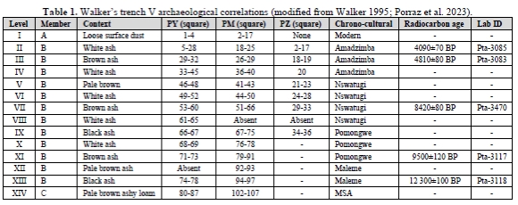
Following up on this work, Walker (1995) later excavated the site in the 1970s. He excavated two trenches, i.e., IV and V, with the deepest at about 1.4 metres. Walker (1995) focused on the LSA stratigraphy only and for both trenches, he excavated 14 units that were subdivided into different squares and subunits. A square consisted of a large horizontal sub-division of the trench. Trench V had three squares, i.e., squares PM, PY, and PZ (Table 1), and these were then divided into spits on the vertical axis. Spits are the subdivisions of the levels, which followed a fixed thickness of 2 cm (rather than following the natural layers of the sediment). Walker (1995) collected all the granite spalls and chips that he came across during his excavations, allowing us to study the spalls from trench V with precise contextual and temporal control derived from the established stratigraphic levels, and to hypothesise patterns of granite spalling. Pomongwe Cave's trenches I and V were re-opened in 2018 by Guillaume Porraz and his colleagues as part of the Matobart Project. This new project aims to clarify the chrono-cultural sequence and chrono-stylistic variation of rock art at the site (Porraz et. al. 2023).
4. Methods of data collection and analyses
Spalls were sampled from all the levels (I-XIV) of square PM only; squares PY and PZ were not sampled because they did not contain spalls in all the levels. The levels for square PM comprise 107 spits in total. Levels can be referred to as the subdivisions of the stratigraphy on the vertical axis in relation to soil colour and textural changes. These levels are then subdivided into different spits. All the levels had spalls but some spits did not contain any spalls, for example spits 18, 26, 39, 41, 45, and 63. Some of the spits that contained spalls are 1, 19, 27, 36, 42, 44 and 51. We analysed 1650 spalls and excluded those that had a length of <1 cm; these were weighed using a scale. Metric measurements such as length, width, and thickness were recorded using a vernier calliper. A calculation of the arithmetic mean of the length, width, thickness, and weight was generated to explore spall size variation. When trench V was re-opened in 2018, the distribution of spalls across the exposed profile was investigated using high-resolution photographs. This provided a visual impression of the distribution of spalls across the different stratigraphic layers.
5. Results
The metric attributes
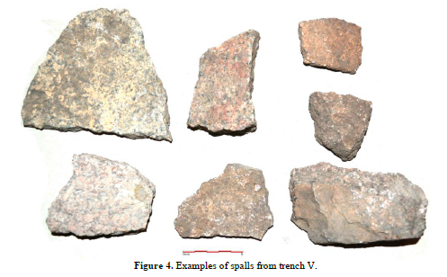
The spalls exhibited a wide range of sizes (Figs 3 & 4), varying significantly across the different spits. This substantial disparity in spall sizes provides an opportunity to explore the relationship between size variations and differing environmental conditions, particularly since these variations occur across distinct stratigraphic levels. For instance, the calculated averages of the spalls reveal that level IV contains the largest spalls, with an average length of 3.2 cm, whereas levels VII and XII contain the smallest spalls, with average lengths of 1.9 cm. These differences in spall size across levels may reflect changes in environmental conditions over time, offering valuable insights into the weathering processes at play.
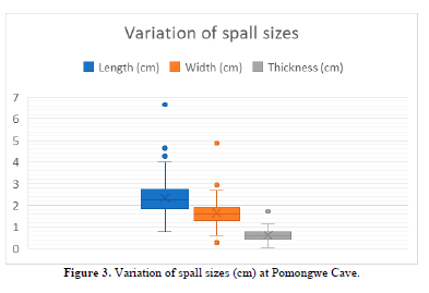
However, the distribution of spall sizes varies across different levels. Some levels contain a mix of both small and large spalls, while others are predominated by either large or small spalls. For example, level X, which contains a total of nine spalls, includes both large and small spalls. In contrast, level VII contains only small spalls, with a maximum mean length of 4 cm. These patterns highlight the variability in spall sizes across different levels, which may reflect distinct environmental or depositional conditions.
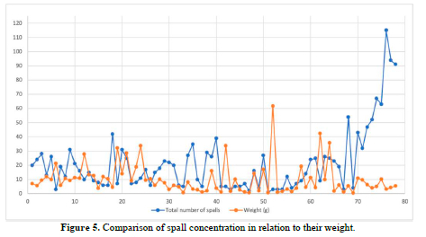
The spall size variation across the different spits becomes evident when comparing the number of spalls and their respective weights (Fig. 5). For instance, spit 76 contains only three spalls, yet these spalls have a significantly higher average weight of 61.67 g. In contrast, spit 6 in level I contains 24 spalls, but the average weight is much lower at 5.62 g. An even more striking example is spit 105, which contains 115 spalls but has a mean weight of just 3.19 g. These comparisons highlight clear differences in spall size, as the average weight decreases significantly as the number of spalls increases. This trend underscores the relationship between spall size and quantity, with larger spalls being fewer in number and smaller spalls being more abundant.
In addition to the analysis of average length and mean weight, the concentration of spalls across levels also revealed significant disparities. Level XIV contains the largest number of spalls, with 482 spalls accounting for 29.2% of the total assemblage. This is followed by level VII, which contains 210 spalls, representing 12.8% of the analysed pieces. In contrast, level X has the fewest spalls, with only nine spalls, making up just 0.5% of the total assemblage. These findings highlight the uneven distribution of spalls across levels, which likely reflects differences in environmental conditions, potentially due to varying types of weathering and their intensity across the stratigraphic layers.
Overall, the relationship between spall counts, average weight, and average length reveals important patterns in the weathering and depositional processes across different levels (supporting online material [SOM] Table 1). Levels with higher spall counts, such as level XIV with 482 spalls, tend to have smaller average weights and lengths, indicating that these levels experienced more intense weathering or fragmentation, resulting in a greater number of smaller spalls. In contrast, levels with fewer spalls, such as level X with only nine spalls, often exhibit larger average weights and lengths, suggesting less intense weathering processes. Other levels, such as level VII with 210 spalls, show intermediate values, reflecting conditions that promote moderate weathering processes. These trends highlight how spall size and quantity are inversely related, with higher spall counts corresponding to smaller, lighter fragments and lower spall counts associated with larger, heavier pieces (Fig. 5). This relationship provides valuable insights into the varying intensity of weathering processes and environmental conditions across the different stratigraphic layers.
6. Discussion
Palaeoenvironmental reconstructions at Pomongwe Cave
The goal of this paper was to ascertain whether granite spalls found in archaeological levels could serve as proxies for reconstructing palaeoenvironments. A sample of spalls recovered from the site of Pomongwe in the Matobo UNESCO World Heritage Landscape were counted, measured, and weighed according to their stratigraphic levels. The results were then compared across stratigraphic levels to see if they showed varying weathering conditions, possibly resulting from varying environmental conditions.
The analyses have demonstrated significant potential for using granite spalls to reconstruct past environmental conditions at the site of Pomongwe. The examination of spall size, weight, and distribution has provided valuable insights into the weathering processes and possible environmental changes that occurred over time. Variations in these attributes across stratigraphic units may imply distinct periods of intense weathering (high spall counts, small spalls), moderate weathering (intermediate spall counts, mixed sizes), and reduced weathering (low spall counts, large spalls).
Drawing on the principles of granite weathering, periods of intense weathering (high spall counts, small spalls) are linked to intense mechanical and chemical weathering processes. These periods likely correspond to warm and humid conditions, where high rainfall and biological activity accelerated the breakdown of granite into smaller fragments (Sumner et al. 2012). The presence of smaller spalls indicates prolonged exposure to moisture, which promotes chemical weathering processes such as hydrolysis and oxidation (Ollier 1984; Goudie & Viles 1997). Such conditions may align with phases of increased precipitation, during which the climate was conducive to rapid rock disintegration. The presence of both small and large spalls suggests intermittent weathering intensity, where periods of moisture alternated with drier conditions (Anderson & Anderson 2010; Sumner et al. 2012). Limited moisture leads to the predominance of mechanical processes such as freeze-thaw cycles, thermal stress, or salt weathering (Marshak 2019). These conditions may correspond to glacial periods or other phases with reduced rainfall.
The uneven distribution of spalls across levels, with some levels predominated by small spalls and others by larger fragments, highlights oscillations between wet and arid conditions at Pomongwe. These variations were driven by climatic changes over time, particularly during the terminal late Pleistocene and early Holocene. The presence of intermediate levels (e.g., level VII) further supports the idea of transitional climatic conditions. Periods of moderate weathering, characterised by intermediate spall counts and a mix of smaller and larger spalls based on their average weights and lengths (e.g., level VII with 210 spalls), are associated with fluctuating environmental conditions. These periods likely represent transitional phases between humid and arid climates. Periods of reduced weathering, characterised by low spall counts (e.g., level X with nine spalls) and predominated by larger spalls with greater average weights and lengths, likely reflect arid or semi-arid conditions.
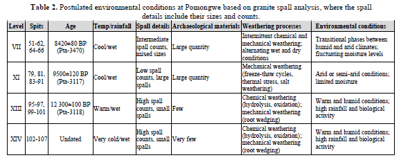
The spall data aligns with regional climatic records, suggesting that Pomongwe experienced cyclical environmental changes similar to those experienced at other sites in southern Africa. These changes were likely influenced by global climatic events, such as glacial-interglacial cycles, which affected rainfall patterns and temperature regimes (Partridge et al. 1997). For example, the Last Glacial Maximum (LGM) in southern Africa is associated with arid conditions and reduced weathering, while the early Holocene is characterised by warmer and wetter conditions, consistent with the patterns observed at Pomongwe (Tyson 1986; Thomas & Shaw 2002; Chase & Meadows 2007). Although the levels studied at Pomongwe do not extend to the LGM, Cooke (1963) has reported a level of large spalls in trench I that could date to the same period, further supporting the link between spall size and climatic conditions.
When combining the data from Pomongwe with previous palaeoenvironmental reconstructions done in Zimbabwe, it shows some interesting correlations (Walker 1995; Katsamudanga & Nhamo 2016). Katsamudanga and Nhamo (2016) indicated that at around 20-35 ka, there was a transition from warm, wet conditions to dry, cool conditions. Walker (1995) noted cold, dry conditions from 20 ka to about 15 ka, after which the climate began to ameliorate, becoming cool and wet by 14 ka (Table 2). Walker's (1995) reconstructions also show that around 12 ka, the temperature was warm and rainfall patterns were moderately wet. Katsamudanga and Nhamo (2016) suggest that conditions were cool between 11 and 12 ka, with wet conditions returning by 10 ka. Walker (1995) indicates slightly cooler conditions at 8 ka, while Katsamudanga and Nhamo (2016) describe wet conditions from 9.4 to 4.8 ka. These patterns reveal frequent oscillations in temperature and moisture at the beginning of the Holocene, reflecting the dynamic nature of the region's climate.
Similar patterns have been identified at other sites in the Matobo Hills, such as at Bambata and Tshangula. Walker (1985) argued that these sites exhibit intense weathering during humid phases and reduced weathering during arid periods, aligning closely with the spall data from Pomongwe. This suggests that the climatic fluctuations observed at Pomongwe were part of a broader regional trend during the late Pleistocene and Holocene.
In the Kalahari region, Thomas and Shaw (1991) have also documented evidence of arid conditions during glacial periods, characterised by reduced spall counts and larger fragment sizes. These findings are consistent with the patterns observed at Pomongwe, further reinforcing the idea that granite spalls have the potential to serve as a reliable proxy for reconstructing past climatic changes across southern Africa.
Human response to palaeoenvironments at Pomongwe Cave
The weathering patterns observed at Pomongwe provide valuable insight into the relationship between environmental conditions and site occupation. Periods of intense weathering (high spall counts) likely coincided with more favourable conditions for human activity, such as increased water availability and vegetation cover. In contrast, aridity - whether from hot or very cold temperatures (low spall counts) - may have challenged resource availability, influencing human mobility and settlement patterns (Deacon & Deacon 1999; Grove 2009). The spall data, combined with archaeological evidence, allow for the exploration of how humans responded to changing environmental conditions over time.
At Pomongwe, levels with archaeological evidence are indicated in Table 2. Cool, wet conditions are indicated for level VII, dated to 8420±80 BP (Pta-3470), which would have supported abundant vegetation and water resources. The large quantity of archaeological remains in this level suggests substantial human occupation during this time, likely due to the favourable environmental conditions. However, level XI (9500±120 BP, Pta-3117), although also reflecting cool, wet conditions, shows a significantly lower number of spalls compared to level VII. This difference may indicate variation in precipitation, with level XI experiencing less intense rainfall. Despite the lower spall count, the substantial quantity of archaeological materials suggests that human occupation persisted, possibly due to the availability of sufficient resources even under slightly drier conditions.
The warm, wet conditions during level XIII, dated to about 12 300±100 BP (Pta-3118), may have promoted intense weathering, leading to minimal human occupation of the cave. The archaeological materials from this level are relatively few, alluding to this possibility. Despite the warm, wet conditions, other factors such as excessive moisture may have made the cave less habitable. This is especially accentuated in level XIV (~13 ka) with wet conditions and high precipitation that must have led to the accumulation of a large number of granite spalls. Level XIV contains the least archaeological materials of all the levels at Pomongwe, which suggests that the cave may have been abandoned due to high precipitation and intense weathering. This may have rendered the cave unsuitable for human habitation, resulting in only sporadic occupation.
7. Conclusion
This study has demonstrated that granite spalls have the potential to be used as a proxy for reconstructing past environments. Patterns of granite spalling reveal that climatic conditions significantly influence the rate of granite exfoliation. Specifically, this study found that cool, wet conditions resulted in fewer, large spalls, as evidenced by the observed accumulation patterns in the stratigraphy. In contrast, high precipitation plays a pivotal role in accelerating the exfoliation of granite, leading to the accumulation of larger quantities of spalls.
The relationship between environmental conditions and human occupation at Pomongwe Cave further underscores the utility of granite spalls as a palaeoenvironmental proxy. The study shows that humans occupied the cave during cool, wet periods, as indicated by the presence of abundant archaeological remains. However, occupation became sparse or ceased entirely around 13 ka, when conditions shifted to being very cold and wet, likely making the cave less habitable. This highlights the dynamic interplay between climate, weathering processes, and human settlement patterns.
While the results presented in this paper help to provide a proof of concept for using granite spalls as a proxy for palaeoenvironmental reconstruction, further investigation is needed to refine and expand this approach. Areas of future research include enhancing our chronological framework to incorporate additional dating methods, such as Optically Stimulated Luminescence (OSL), that will facilitate stronger inter-site correlation with regional climatic events. Another would be the analysis of granite spalls from other trenches both at Pomongwe, and at all the other sites across Zimbabwe and southern Africa where granite spalls occur. This would enable the identification of broader trends in their occurrence, further validating their reliability as proxies across different climatic contexts. The development of quantitative models to correlate spall size, weight, and concentration, with specific climatic parameters such as rainfall intensity and temperature fluctuations, would also improve the usefulness of granite spalls as palaeoenvironmental proxies.
In terms of methodology, the employment of macro and micro-scale analyses of the granite spalls, including observations of weathering patterns, abrasions, and surface textures, in addition to measuring their lengths, widths, and thicknesses, would add critical data on spall occurrences that could then facilitate palaeoenvironmental reconstructions. This additional analysis would provide a more comprehensive basis for concluding how the spalls were formed under the prevailing past environmental conditions. Furthermore, the investigation of the material culture found at Pomongwe during warm, wet periods, to determine whether favourable environmental conditions fostered experimentation and innovation in tool making and other technologies, is also important. It is known that environmental conditions led to the development of many technological innovations in the past. Therefore, it would be beneficial to correlate the technological developments with the environmental conditions deduced from analyses of spalling. For example, technological innovations such as the geometric backed artefacts coming from the Amadzimba period at Pomongwe (Chiwara-Maenzanise et al. 2025) may have been environmentally driven.
A closer scrutiny of the occupation history of Pomongwe, particularly during the early Holocene, would also be beneficial. While this study suggests a possible occupation break around 13 ka due to very cold and wet conditions, such conclusions require further investigation to: 1) determine whether there was continuity or discontinuity in occupation during the early Holocene, and 2) explore the factors that led to the reoccupation of the cave. The integration of data from other palaeoenvironmental proxies, such as pollen and stable isotopes, will further help to create a more comprehensive reconstruction of past climates. By addressing these key areas, future research can assess whether granite spalls are a robust and versatile tool for palaeoenvironmental reconstruction, contributing to a deeper understanding of past climatic changes and their impact on human societies. Additionally, exploring the material culture and technological innovations associated with different climatic periods will provide insights into how human populations adapted to and thrived in varying environmental conditions.
Acknowledgements
We acknowledge that this paper is a result of the research carried out by Thubelihle Mnkandla during her Masters studies at the University of Zimbabwe. Our gratitude is extended to the leaders of the Matobart Project, Guillaume Porraz, Camille Bourdier and Ancila Nhamo, for giving Thubelihle the opportunity to be part of this project and for allowing us to use the images from this project in our publication. We also want to thank Humphrey Nyambiya for the map used in this paper. Special thanks also go to the reviewers and editors of the Southern African Field Archaeology Journal for their constructive comments that improved our paper.
Supporting online material
Mnkandla & Nhamo Supporting Online Material File 1
References
Anderson, R.S. & Anderson, S.P. 2010. Geomorphology: The Mechanics and Chemistry of Landscapes. Cambridge: Cambridge University Press. [ Links ]
Backwell, L.R., McCarthy, T.S., Wadley, L., et al. 2014. Multiproxy record of late Quaternary climate change and Middle Stone Age human occupation at Wonderkrater, South Africa. Quaternary Science Reviews, 99: 42-59. [ Links ]
Basu, P. & Bondyopadhyay, M.K. 2014. Some features of weathering in the eastern-north Karanpura basin, Sharkhand, India. International Journal of Geology, Earth and Environmental Sciences, 4(2): 191-207. [ Links ]
Boggs, S. 2006. Principles of Sedimentology and Stratigraphy. California: Pearson Prentice Hall. [ Links ]
Bond, G. 1949. The geology, climates and cultures of the Pleistocene period in Matebeleland, Southern Rhodesia. Doctoral Thesis. Salisbury: University of Rhodesia. [ Links ]
Bond, G. 1957. The geology of the Khami Stone Age sites. Occasional Papers of the National Museums of Southern Rhodesia, 21(A): 115-130. [ Links ]
Bond, G. 1964. Pleistocene environments in southern Africa. In: Howell, F. & Bourliere, F. (eds) African Ecology and Human Evolution: 308-334. Chicago: Aldine. [ Links ]
Bond, G. 1965. Quantitative approaches to rainfall changes in the Quaternary of southern Africa. In: Wright, H. E. & Frey, D.G. (eds) International Studies on the Quaternary: Papers Prepared on the Occasion of the VII Congress of the International Association of Quaternary Research: 323-336. Colorado: Geological Society of America. [ Links ]
Bond, G. & Clark, J.D. 1954. The Quaternary sequence in the middle Zambezi Valley. South African Archaeological Bulletin, 9(36): 115-130. [ Links ]
Brain, C.K. 1969. New evidence for climatic change during Middle and Late Stone Age times in Rhodesia. South African Archaeological Bulletin, 24(95/96): 127-143. [ Links ]
Braun, K., Nehme, C., Pickering, R., et al. 2019. A window into Africa's past hydroclimates: The SISAL_v1 Database Contribution. Quaternary, 2(1): 1-33. [ Links ]
Broderick, T. & Hubbard, P. 2016. The Matobo Hills of Zimbabwe: A perfect blend of geology, scenery and human history. In: Anhaeusser, C.R., Viljoen, M.J. & Viljoen, R.P. (eds) Africa's Top Geological Sites: 33-38. Cape Town: Struik Nature. [ Links ]
Chase, B.M. & Meadows, M.E. 2007. Late Quaternary dynamics of southern Africa's winter rainfall zone. Earth Science Reviews, 84(3-4): 103-138. [ Links ]
Chiwara-Maenzanise, P., Nhamo, A. & Porraz, G. 2025. Morphological and functional variability of the geometric microlithic backed tools from the late Holocene at Pomongwe Cave (Matobo, western Zimbabwe). Southern African Field Archaeology, 20: 3561. [ Links ]
Cooke, C.K. 1963. Report on excavations at Pomongwe and Tshangula Cave, Matopo Hills, Southern Rhodesia. South African Archaeological Bulletin, 18(7): 73-151. [ Links ]
Cooke, C.K. 1971. Excavation at Zombepata Cave, Sipolilo District, Mashonaland, Rhodesia. South African Archaeological Bulletin, 26(103): 104-126. [ Links ]
Cruz-Uribe, K. 1983. The mammalian fauna from Redcliff Cave, Zimbabwe. South African Archaeological Bulletin, 38(137): 7-16. [ Links ]
Deacon, H.J. & Deacon, J. 1999. Human Beginnings in South Africa: Uncovering the Secrets of the Stone Age. Walnut Creek: AltaMira Press. [ Links ]
Dollar, S.J.E. 1998. Paleofluvial geomorphology in southern Africa: A review. Progress in Physical Geography, 22(3): 325-349. [ Links ]
Goudie, A.S. & Viles, H.A. 1997. Weathering and the Landscape: Geomorphological Perspectives. New York: Wiley. [ Links ]
Grout, F.F. 1935. The composition of some African granitoid rocks. Journal of Geology, 43(3): 281-296. [ Links ]
Grove, M. 2009. Hunter-gatherer movement patterns: Causes and constraints. Journal of Anthropological Archaeology, 28: 222-233. [ Links ]
Haynes, G. 1996. Quarternary climates and environment in Hwange National Park, Zimbabwe. In: Pwiti, G. & Soper, R. (eds) Aspects of African Archaeology: Papers from the 10th Congress of the Pan-African Association for Prehistory and Related Studies: 71-81. Harare: University of Zimbabwe Publications. [ Links ]
Holzkämper, S., Holmgren, K., Lee-Thorp, K., et al. 2009. Late Pleistocene stalagmite growth in Wolkberg Cave, South Africa. Earth and Planetary Science Letters, 282: 212-221. [ Links ]
Katsamudanga, S. & Nhamo, A. 2016. A review of the reconstructed palaeoenvironmental record of Zimbabwe and call for multidisciplinary research. Palaeogeography, Palaeoclimatology, Palaeoecology, 461: 460-471. [ Links ]
Marshak, S. 2019. Earth: Portrait of a Planet. Sixth Edition. New York: W.W. Norton & Company. [ Links ]
Mellars, P. 2006. Why did modern human populations disperse from Africa ca. 60,000 years ago? A new model. Proceedings of the National Academy of Sciences, 103(25): 9381-9386. [ Links ]
Migon, P. 2006. Granite weathering. In: Migon P. (ed.) Granite Landscapes of the World: Geomorphological Landscapes of the World. 24-82. Oxford: Oxford University Press. [ Links ]
Mugumbate, F. 2013. On naturally sculptured granites in Zimbabwe. Address to the Geological Society of Zimbabwe AGM 2013, Harare, Zimbabwe. [ Links ]
Nhamo-Katsamudanga, A. & Chiwara-Manezanise, P. 2023. Pleistocene archaeology of Zimbabwe: An overview. In: Beyin, A., Wright, D.K., Wilkins, J., et al. (eds) Handbook of Pleistocene Archaeology in Africa: Human Behaviour, Geography and Chronology: 1203-1224. Cham: Springer. [ Links ]
Ollier, C. 1984. Weathering. Second Edition. London: Longman. [ Links ]
Partridge, T.C., Scott, L. & Schneider, R.R. 1997. Environmental changes in southern Africa during the Last Glacial Maximum. Quaternary Science Reviews, 16(9): 841-859. [ Links ]
Plummer, C.C., Hammersley, L. & Carlson, D. 2016. Physical Geology. Fifteenth Edition. New York: McGraw-Hill Companies. [ Links ]
Porraz, G., Nhamo, A. & Bourdier, C. 2023. Pomongwe Cave, Zimbabwe. In: Beyin, A., Wright, D.K., Wilkins, J., et al. (eds) Handbook of Pleistocene Archaeology of Africa: Hominin Behavior, Geography, and Chronology: 1225-1237. Cham: Springer. [ Links ]
Potts, R. 1998. Environmental hypotheses of hominin evolution. American Journal of Physical Anthropology, 107(S27): 93-136. [ Links ]
Pye, K. Goudie, A.S. & Thomas, D.S.G. 1984. A test of petrological control in the development of bornhardts and koppies on the Matopos Batholith, Zimbabwe. Earth Surface Processes and Landforms, 9: 455-467. [ Links ]
Robinson, J.R. 2023. A context for connectivity: Insights to environmental heterogeneity in the Late Pleistocene and Holocene of southern Africa through measuring isotope space and overlap. Journal of Palaeolithic Archaeology, 6(34): 1-48. [ Links ]
Smith, C.G. 1968. Some aspects of the geology of the Matopos. Honours Report. Salisbury: University of Rhodesia. [ Links ]
Summers, R. 1960. Environment and culture in southern Africa: A study in the personality of a land-locked country. Proceedings of the American Philosophical Society, 104(3): 266-293. [ Links ]
Sumner, P.D., Hall, K.J., Meiklejohn, K.I., et al. 2012. Weathering. In: Holmes, P. & Meadows, M. (eds) Southern African Geomorphology: Recent Trends and New Directions. 75-93. Bloemfontein: Sun Media Bloemfontein. [ Links ]
Thomas, D.S.G. & Shaw, P.A. 1991. The Kalahari Environment. Cambridge: Cambridge University Press. [ Links ]
Thomas, D.S.G. & Shaw, P.A. 2002. Late Quaternary environmental change in central southern Africa: New data, synthesis, issues and prospects. Quaternary Science Reviews, 71(7): 783-797. [ Links ]
Twidale, C.R. 2012. Granite landscapes. In: Holmes, P. & Meadows, M. (eds) Southern African Geomorphology: Recent Trends and New Directions: 41-72. Bloemfontein: Sun Media Bloemfontein. [ Links ]
Tyson, P.D. 1986. Climate Change in Southern Africa. Oxford: Oxford University Press. [ Links ]
UNESCO. 2003. Advisory Board Evaluation (ICOMOS): Matobo Hills (Zimbabwe) No 306 Rev. Available from: https://whc.unesco.org/en/documents/153151 (Accessed: 2025) [ Links ]
Walker, N.J. 1985. Late Pleistocene and Holocene hunter-gatherers of the Matopos. Quaternary Research, 24(2): 147-161. [ Links ]
Walker, N.J. 1995. Late Pleistocene and Holocene Hunter-Gatherers of the Matopos: An Archaeological Study of Change and Continuity in Zimbabwe. Uppsala: Societas Archaeologica Upsaliensis. [ Links ]
Received February 2025
Revised May 2025
Published July 2025
* Corresponding author email: tmnkandla@arts.uz.ac.zw
