


Services on Demand
Journal

Article
 English (pdf)
 Article in xml format
 Article references
 Send this article by e-mail
Indicators
Related links
-
 Cited by Google
 -
 Similars in Google
Share

 Permalink
Southern African Field Archaeology
On-line version ISSN 2789-1844Print version ISSN 1019-5785
South. Afr. Field Archaeol. vol.20 Johannesburg 2025
https://doi.org/10.36615/safa.20.3540.2025
PEER-REVIEWED RESEARCH REPORT
Archaeological survey of the Modder River dongas, Free State, South Africa
Felipe Cuartero MonteagudoI, II; Maïlys RichardIII, IV; Lloyd RossouwV, VI; Michael B. ToffoloI, III, V
IGeochronology and Geology Programme, National Research Centre for Human Evolution (CENIEH), Paseo Sierra de Atapuerca 3, 09002 Burgos, Spain
IIDepartment of History and Philosophy, University of Alcalá, Calle Colegios 2, 28801 Alcalá de Henares, Spain
IIIArchéosciences Bordeaux, UMR 6034 CNRS-Bordeaux Montaigne University, Esplanade des Antilles, 33607 Pessac, France
IVDepartment of Early Prehistory and Quaternary Ecology, University of Tübingen, Burgsteige 11, 72070 Tübingen, Germany
VDepartment of Plant Sciences, University of the Free State, Zastron Street, 9301 Bloemfontein, South Africa
VIFlorisbad Quaternary Research Department, National Museum Bloemfontein, 9301 Bloemfontein, South Africa
ABSTRACT
The semi-arid grasslands of the Free State Province of South Africa have produced the earliest evidence of the presence of Homo sapiens in the subcontinent, together with an extensive Pleistocene palaeoenvironmental record based on fossil assemblages. However, the known Middle Stone Age (MSA) archaeological sites in the Free State are limited to a few major localities that cannot be integrated into a unitary narrative, thus hindering our understanding of human cultural evolution in the central interior of South Africa. Here we report the results of a survey of the dongas of the Modder River aimed at documenting new localities embedded within its alluvial terraces. We identified 43 previously unknown archaeological areas spanning the Late Pleistocene to Holocene based on the regional chronology, of which the majority are MSA sites. Four of the latter include artefacts in situ and thus hold potential for excavation and absolute dating by trapped-charge methods. The occurrence of a specific lithic type at six sites along the course of the river highlights a pattern in the occupation of the region during Marine Isotope Stage 5, which confirms the importance of the grasslands of the central interior for the characterisation of the spatiotemporal distribution of human groups in the open landscape during the MSA.
Keywords: Pleistocene; South Africa; Modder River; Middle Stone Age; Later Stone Age
1. Introduction
Homo sapiens emerged in Africa in the late Middle Pleistocene, around 300 000 years ago, and their appearance broadly overlaps with the onset of the Middle Stone Age (MSA) (Deino et al. 2018; Bergström et al. 2021). This archaeological period is characterised by increased evidence of symbolism (e.g., Bouzouggar et al. 2007; Watts et al. 2016; d'Errico et al. 2020), social networking (e.g., Lombard 2012; Brooks et al. 2018; Stewart et al. 2020), technological advancements in tool manufacture (e.g., Wadley et al. 2009; Mourre et al. 2010), and use of fire (e.g., Schmidt et al. 2020; Wadley et al. 2020a, b). In addition, the MSA saw a persistent population expansion into a wide range of ecosystems, including deserts, rainforests, and high mountains, which were only marginally occupied in earlier periods (Jones & Stewart 2016; Roberts & Stewart 2018).
In southern Africa, the earliest H. sapiens fossil is from the interior of the subcontinent, where the Florisbad spring site in the Free State Province of South Africa (henceforth Free State) produced the partial cranium of a basal H. sapiens (Dreyer 1935; Clarke 1985; Grün et al. 1996; Grün & Stringer 2023). The site also yielded one of the few dated assemblages of early MSA lithic artefacts in South Africa (Kuman et al. 1999) and a palaeoenvironmental sequence based on pollen and sedimentary analyses (Rubidge & Brink 1985; Kuman et al. 1999; Toffolo et al. 2015, 2017; Scott et al. 2019), and it is the type locality of the Florisian Land Mammal Age (Brink 1987, 1988, 1994; Brink & Lee-Thorp 1992; Brink & Henderson 2001; Codron et al. 2008; Manegold & Brink 2011). The latter indicates the existence of an extensive system of palaeolakes and wetlands in this region during the Middle and Late Pleistocene, which supported large animal populations in an open grassland ecosystem (Brink 2016).
Recent research in the Kalahari Basin has produced palaeoenvironmental evidence that confirms the importance of the arid and semi-arid interior of southern Africa in the evolution of early H. sapiens (Wilkins 2021; Wilkins et al. 2021; Burrough et al. 2022; Lukich & Ecker 2022; Ecker et al. 2023).
However, despite this renewed interest and the growing number of studies focused on the interior of southern Africa, only a few archaeological sites offer accurate and long chronologies, and as a result vast swathes of land remain archaeologically blank with regard to the Pleistocene record, especially in the case of the grasslands of the Free State (Toffolo 2024). This hinders a proper assessment of human settlement dynamics in the region and our ability to establish causal links between climate change and human adaptive strategies (e.g., Faith et al. 2021).
In this paper, we report the results of an archaeological survey of the Modder River in the western Free State, which was carried out with the aim of documenting the occurrence of artefacts and fossils within dongas. Dongas are a common geomorphological feature in the South African landscape, comprising extensive erosional gullies and crests produced by surface runoff of water during thunderstorms in areas characterised by poor plant cover. These features are found mainly in river terraces and less frequently in lunette dunes around pans, and are especially important for archaeologists because they offer a comprehensive view of Pleistocene stratigraphy and often contain stratified sites (e.g., Brink et al. 1999; de la Peña & Witelson 2020; Will et al. 2024). This aspect is particularly crucial because the presence of a sedimentary matrix allows the application of trapped-charge dating methods, which is not possible when artefacts and fossils are found in surface scatters.
Portions of the Modder have been the object of surveys since at least the 1920s (e.g., Goodwin & van Riet Lowe 1929), although they were rarely published (Churchill et al. 2000; Rossouw 2006) and usually confined to archaeological impact assessments (e.g., by the National Museum Bloemfontein) and dissertations (Tsokeli 2005; Trower 2010). Excavations, on the other hand, have been focused on only a handful of sites, such as Kranskraal (van Hoepen 1932), Erfkroon (Bousman et al. 2023), Lovedale (Wroth et al. 2022), and Damvlei (Toffolo et al. 2023). In 2022, we initiated a new survey programme of all the dongas along the major rivers in the western Free State as part of the project 'PalaeoEcology and OPen-LandscapE adaptations of Pleistocene humans in South Africa' (PEOPLE), which aims to understand the role that freshwater availability had in the evolution of H. sapiens in the semi-arid grasslands of the Free State. Therefore, this study presents the first comprehensive survey of the Modder dongas between Rustfontein Dam and the Rademansval locality and a description of all the archaeological areas that were encountered. The sites are discussed within the chronological and archaeological context of the Free State and help build an archaeological map of the Modder catchment.
2. Regional setting
The Modder is a meandering river that flows ~370 km through the western Free State in a south-north direction from its headwaters near Dewetsdorp to Maselspoort, and then in an east-west direction until its confluence into the Riet River at Modderrivier, immediately to the west of the border with the Northern Cape (Barker 2011) (Fig. 1). Together with the Riet and the Vet-Sand, the Modder is one of the few rivers flowing in the semi-arid western Free State, which is mainly part of the Grassland Biome (Dry Highveld Grassland Bioregion) but includes also the Savanna Biome (Eastern Kalahari Bushveld Bioregion) at the border with the North West and Northern Cape and the Nama-Karoo Biome (Upper Karoo Bioregion) at the border with the Northern Cape (Mucina & Rutherford 2006).
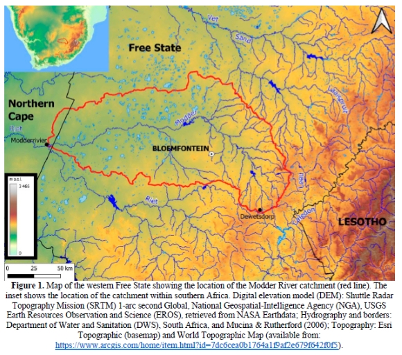
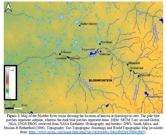
The catchment of the Modder River (17 360 km2) is characterised by a narrow valley bordered by dolerite hills and sills in its eastern portion (east of Bloemfontein), whereas the western portion features a wide valley with a deeply incised riverbed and local gradient <1°, which exposed a series of alluvial terraces (Myburgh 1997; Barker 2011; Tooth et al. 2013). The latter are in many places further incised by dongas, which produced archaeological sites such as Erfkroon, Lovedale, Damvlei, Mitasrust, Kranskraal, and Waterval. Other known sites within the Modder catchment include Florisbad, Vlakkraal (Wells et al. 1942), and Baden-Baden (van Aardt et al. 2016) (Fig. 2).
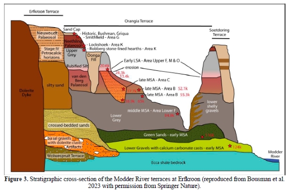
At least three alluvial terraces are known to exist between five and 33 m above the Modder riverbed, although in discontinuous portions along its course (Myburgh 1997). Detailed sedimentological, chronological, and archaeological research at Erfkroon, a donga located on the right bank of the Modder 67 km northwest of Bloemfontein, produced a chronostratigraphic sequence of four alluvial terraces (Churchill et al. 2000; Tooth et al. 2013; Lyons et al. 2014; Palmison 2014; Brink et al. 2016; Morris 2019; Bousman et al. 2023). These terraces are called, from oldest to youngest, Wolwespruit, Erfkroon, Orangia, and Soetdoring (Fig. 3). Only the Orangia terrace bears artefacts and fossils, which punctuate a sedimentary sequence representing the Late Pleistocene and Holocene divided into four major allostratigraphic units and comprising two palaeosols and five lithostratigraphic beds (Bousman et al. 2023). More specifically, the Lower Grey Bed includes MSA occupations dated by luminescence between ~99 and ~55 ka; the van den Berg (Red) Palaeosol comprises late MSA occupations dated between ~55 and ~28 ka; the rubified silt at the base of the Upper Grey Bed produced an early Later Stone Age (LSA) occupation dated to ~21 ka; the upper portion of the Upper Grey Bed yielded an undated Robberg occupation; and the Neethling (Brown) Palaeosol is characterised by Lockshoek (Oakhurst) occupations, which in South Africa are dated to the first half of the Holocene (Lombard et al. 2022). Remarkably, a similar stratigraphic sequence comprising a Lower Grey Bed with MSA artefacts, a Red Palaeosol with late MSA artefacts, an Upper Grey Bed with LSA artefacts, and a brown sediment with LSA artefacts, was identified at Waterval, a donga located on the right bank of the Modder near Sannaspos, 32 km east of Bloemfontein and 94 km southeast of Erfkroon as the crow flies, suggesting that the chronostratigraphic sequence established at Erfkroon may be applicable all along the course of the river (Trower 2010). This stratigraphic framework was used as reference during the survey to help contextualise different MSA clusters within the same donga and to facilitate comparisons between dongas. Not all surveyed dongas exhibit the complete Orangia sequence, presumably because of advanced erosion, and thus assigning artefacts to one bed or another remains difficult in some cases due to the absence of absolute ages. In addition, one should keep in mind that the Red Palaeosol developed on pre-existing sediments, and therefore its age may vary to some extent along the river. Nevertheless, the Erfkroon stratigraphy is a good starting point to propose a relative chronological sequence for the findings of the survey.
3. Methods
Our survey of the Modder dongas spanned the portion of the river between Rustfontein Dam, 50 km to the southeast of Bloemfontein, and the locality of Rademansval, 90 km to the west of Bloemfontein, covering almost 160 km of its course. Dongas were identified using Google Earth, where they appear as light-coloured patches of land next to the riverbed that stand out compared to the surrounding vegetated areas. The historical imagery function allowed us to visualise dongas in different seasons (dry vs. wet) and under different light conditions, which is particularly useful to determine the presence of deeply incised gullies (based on the size of shaded areas) and to assess their potential for the preservation of Pleistocene deposits. We also used the imagery provided by the CDNGI Portal of the Department of Rural Development and Land Reform of South Africa (http://www.cdngiportal.co.za/CDNGIPortal/) and the topographic map of South Africa (https://htonl.dev.openstreetmap.org/ngi-tiles/ # 6/-28.621/24.625). The selected dongas were surveyed on foot after locating the landowners and obtaining their permission to access the properties. No significant dongas exist between Rademansval and Modderrivier and for this reason that portion of the river was not surveyed.
The survey comprised the visual inspection of exposed donga surfaces to identify clusters or concentrations of artefacts as well as single spots or occurrences of pieces in sections, and/or any associations between faunal remains and lithic artefacts. The dongas were first surveyed following their perimeters and main drainage channels to establish the local stratigraphic sequence and to locate artefact concentrations. Then, each donga was systematically surveyed in the areas that showed significant concentrations of knapped artefacts and/or fossils, counting first these archaeo-palaeontological remains with overall counts by area. After, we determined (by visual assessment) the centroid of each area based on it having a higher artefact/fossil density. We identified archaeological areas when clusters of 10 or more artefacts occurred within a surface area of 10 000 m2 (density ratio=0.001 artefacts per m2); lower densities were considered as isolated findings. The boundary between archaeological areas was arbitrarily set when there was a distance of at least 100 m from the centroid (cluster) of an archaeological area and the next. In addition, the stratigraphic framework established by Bousman et al. (2023) at Erfkroon and Trower (2010) at Waterval was used as reference to distinguish archaeological areas of different age. Artefacts and faunal remains were recorded by GPS, documented with photographs and analysed in 1 m square grids. This grid was placed at the centroid and counts were recorded of all recognisable knapped artefacts including chips under 2 cm, but excluding chunks or angular fragments where intentional knapping could not be identified. After each count the grid was moved to neighbouring parts of the cluster/concentration, as many times as necessary, until reaching artefact densities of <1/m2. No artefacts or fossils were collected during survey; after study, they were placed in the same position where they were found.
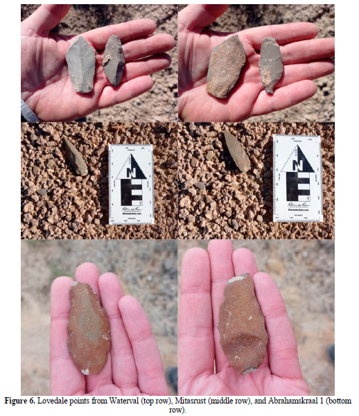
The counts of stone tools have been compiled indicating their technological categories, the raw materials, the degree of preservation, and the sedimentary context where the artefacts were found. The technological categories are divided into cores, debitage, and retouched pieces. Retouched pieces follow some conventional terms such as sidescraper, endscraper, denticulate, notch, borer, burin, backed blade or bladelet, pièce esquillée, knife, unifacial point, adze, and geometric. We also include the counts of Lovedale points, "(...) a narrow tool made on a blade with trimmed tips and bifacially trimmed bases, which removes the striking platforms and most of the bulbs of percussion", due to their restricted geographical and chronological range in the Free State, which allows comparisons with dated sites in the region (Wroth et al. 2022: 11). Unknapped blocks or cobbles are classified into cobble, block, hammerstone, and grindstone categories. Debitage is classified as non-diagnostic flake, flake fragment, blade, blade fragment, small flakes and chips (<2 cm), Levallois point, and Levallois flake categories. The size of the artefacts is classified into large (>8 cm), medium (4 to 8 cm), small (<4 to 2 cm), and microlithic (<2 cm) categories. The classification of cores follows Conard et al. (2004) and includes parallel (Levallois), platform, inclined (discoidal), initial, bipolar, and multidirectional types. When further details are considered in platform cores, the most abundant type in our surveys, we follow the classification system of Porraz et al. (2016), which considers the following sub-types: high-backed, narrow-sided, frontal, conic, bipolar, and bipolar reduced. Furthermore, when some additional details are described for retouched tools, we define the invasiveness of the retouch according to Bader et al. (2016), which essentially simplify the criteria of Clarkson (2002). All the artefacts that we found are made on hornfels unless otherwise specified, as hornfels is the only locally available raw material used during the MSA.
The depositional context of the artefacts was recorded according to their primary or secondary positions, indicating the landform where the artefacts were found. Primary contexts include artefacts identified in vertical sections that are naturally exposed by the erosional processes at work in dongas, usually within convex slopes or ridges. Artefacts found on the surface were considered to be in secondary contexts. Similarly, artefacts located on concave slopes, flat steps (eroded high surfaces) or gullies belong to the category of secondary contexts. We also distinguished palaeochannels in exposed sections, where erosion and transport took place in the past and thus redeposited older material. Based on the stratigraphic position of our findings, we specified the main sedimentary features of the layer containing them (visible or preserved thickness of the deposit, matrix and clast composition, colour) and their relative position compared to other layers.
4. Results
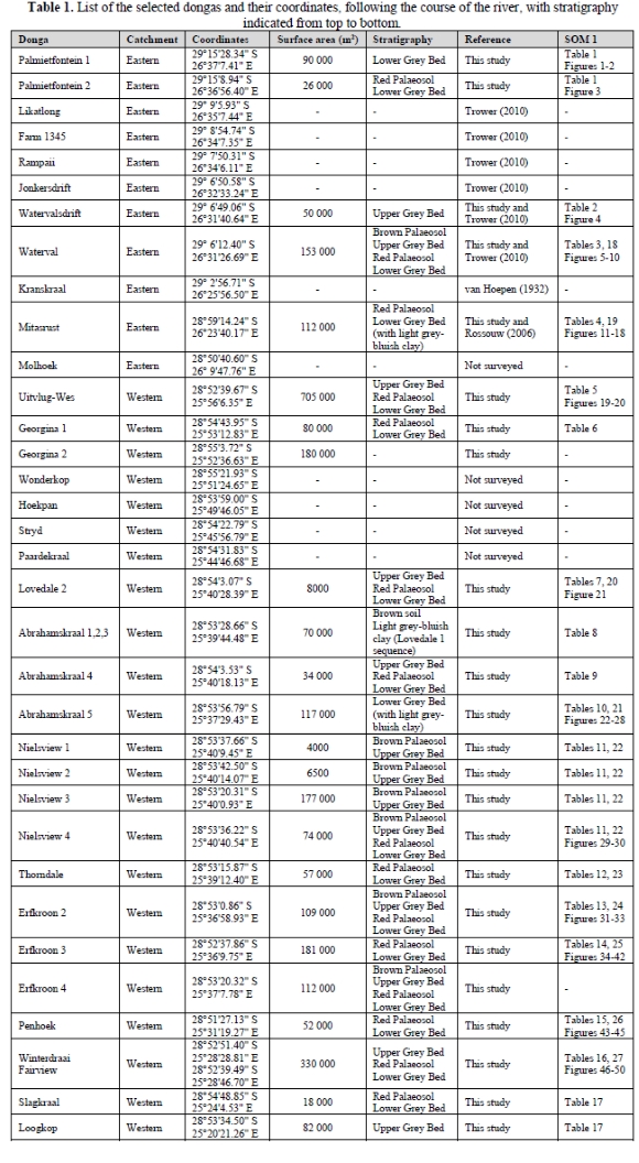
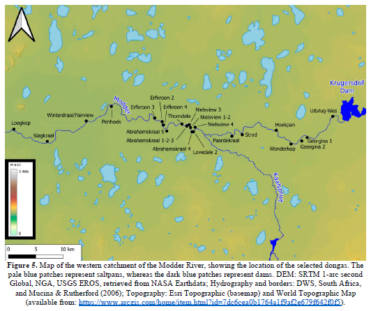
We identified 34 dongas with potential for preserving deep (>2 m) stratigraphic sequences, of which 25 were surveyed on foot; the remainder could not be accessed because we could not locate the owners or they did not want to provide access for different reasons (e.g., presence of large game) (Table 1). During the survey, we recorded 755 lithic artefacts and 28 faunal remains (whole or fragmented). The Supplementary Online Material (SOM) reports artefact counts by technological category (SOM 1 Tables 1-17) and by raw material (SOM 1 Tables 18-27) and provides descriptions of the main finds (SOM 1 Figs 1-50). The dongas and the archaeological areas they contain are described following the course of the river, downstream from Rustfontein Dam to the Rademansval locality, and are divided into eastern and western catchments. The former goes from Rustfontein Dam to Maselspoort, whereas the latter spans from Krugersdrif Dam to Rademansval. This arbitrary division is proposed because only one donga of interest exists between Maselspoort and Krugersdrif Dam, but it could not be accessed (Molhoek). The eastern catchment includes 10 dongas, six of which were surveyed: Palmietfontein 1 and 2, Watervalsdrift, Waterval, Kranskraal, and Mitasrust (Fig. 4). Kranskraal, which was excavated by van Hoepen (1932) and produced an MSA occupation, is not reported here as it will be the subject of a dedicated study. The western catchment includes 23 dongas, 19 of which were surveyed: Uitvlug-Wes, Georgina 1 and 2, Lovedale 2, Abrahamskraal 1-3, 4 and 5, Nielsview 1, 2, 3, and 4, Thorndale, Erfkroon 2, 3, and 4, Penhoek, Winterdraai/Fairview, Slagkraal, and Loogkop (Fig. 5).
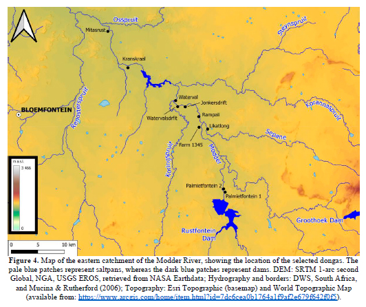
Eastern catchment
Palmietfontein: Palmietfontein 1 and 2 have a relatively wide surface but shallow reliefs because of advanced erosion. Palmietfontein 1 features a single archaeological area (A1) characterised by grey sediments comprising sandy clay (in places exhibiting a more reddish to brown colour) covered with small calcium carbonate nodules. One locale is characterised by a great number of rounded clasts of dolerite, shale, and hornfels, which are interpreted as a palaeochannel deposit. Only a few artefacts have been identified in this donga, including an isolated proximal Levallois point fragment and non-diagnostic rounded flakes and flake fragments in the palaeochannel gravels. The occurrence of the Levallois point fragment in the grey sediment may be interpreted as a parallel with the Lower Grey Bed at Erfkroon. Palmietfontein 2 exhibits a red horizon probably equivalent to the Red Palaeosol, which is almost completely eroded and features a single area with ridges up to 0.5-0.7 m in height in the central portion of the donga. Grey sandy clay, with calcium carbonate nodules, was observed underneath the red horizon, which may facilitate correlation with the Lower Grey Bed at Erfkroon. A total of eight non-diagnostic flakes of hornfels and sandstone were found on the slopes of the eroded Red Palaeosol, at the contact with the underlying grey sediment (SOM 1 Table 1; Figs 1-3).
Waterval: Waterval is a wide and deep (8 m between its top and the riverbed) donga that corresponds to 'Area A' in Trower (2010). The stratigraphy of the sediments cut by the donga matches the Lower Grey Bed-Red Palaeosol-Upper Grey Bed succession at Erfkroon, with the Red Palaeosol being less visible close to the river and clearer at the edge of the donga. We differentiate three archaeological areas according to the density of finds. Area 1, the westernmost, is located between the river and a high crest, which allows for stratigraphic control. The majority of the artefacts found here occur in the Lower Grey Bed, a thick layer (2.5 to 3 m) of grey sandy clay with calcium carbonate nodules underlying the Red Palaeosol (0.8 to 1 m thickness), the Upper Grey Bed (2.6 to 2.8 m), and the Brown Palaeosol (0.5 to 0.7 m) at the top. Finds appear at the surface of concave and convex slopes of a less eroded zone with dome-shaped ridges, and include: seven flakes, an inclined core, and a dolerite cobble. Other artefacts were found on the highest part of the eroded ridges of the Upper Grey Bed (a grindstone) or the bottom of gullies filled with sand (a unifacial point and a Levallois point, both highly weathered) (SOM 1 Figs 5-6). Area 2 produced sparse faunal remains, with shaft fragments of long bones of large mammals and a cluster of MSA tools that includes a Lovedale point (Fig. 6), a unifacial point and several elongated flakes in hornfels and sandstone with faceted platforms. These items were found at the surface of an eroded zone with convex ridges within the Lower Grey Bed (SOM 1 Figs 7-9). Area 3, finally, contains numerous LSA artefacts including many small narrow-sided platform cores in hornfels and fine-grained siliceous rocks, some convex scrapers and a microlithic artefact (a trapeze) in chert or a similar rock (SOM 1 Tables 3, 18). This area is located at the surface of long, convex and extensively eroded ridges within the Upper Grey Bed. Some MSAlike artefacts located in this area suggest a displacement of pieces from this period in the floodplain or, as proposed earlier by Trower (2010), a possible re-use of older artefacts by LSA groups inhabiting the area (SOM 1 Fig. 10). We estimate similar densities for Areas 1, 2, and 3, at around 0.01 artefacts per m2. When comparing our work with the results of Trower (2010), we find that we have documented very few artefacts both in Watervalsdrift and Waterval, but the type of information we recorded is consistent with his data in terms of lithic technology, especially for Waterval. Our finds were significantly less numerous and the fauna was less preserved, probably as a result of the collection of artefacts and fauna during the previous survey.
Mitasrust: Mitasrust was surveyed by Rossouw (2006), who collected Florisian fauna and observed MSA artefacts. The surface, exposed by erosion, covers a large area with a main donga channel that goes from the west to the east. The main donga exhibits several tall profiles (up to 5 m in height) where the uppermost levels are characterised by silts and sands presumably deposited during the Holocene that cover thick layers of small, cemented gravels at the base of sections (SOM 1 Figs 11 -12). The tributary dongas to the south exposed a large area, the western portion of which exhibits a Red Palaeosol-Lower Grey Bed sequence, whereas the eastern portion is characterised by light grey-bluish sandy clay deposits with calcium carbonate nodules consistent with the Lower Grey Bed. The zone located to the south of the main drainage channel shows two separated archaeological areas with high densities of artefacts. Area 1, to the east, has 16 artefacts in a surface of 752 m2 (density=0.021), whereas Area 2, to the west, has 32 pieces in 1218 m2 (density=0.026). Both areas show MSA artefacts associated with faunal remains and some isolated LSA artefacts covered with brown patina (mostly endscrapers and one adze) that most likely come from the overlying Red Palaeosol, which is almost completely eroded away in these areas (SOM 1 Tables 4, 19).
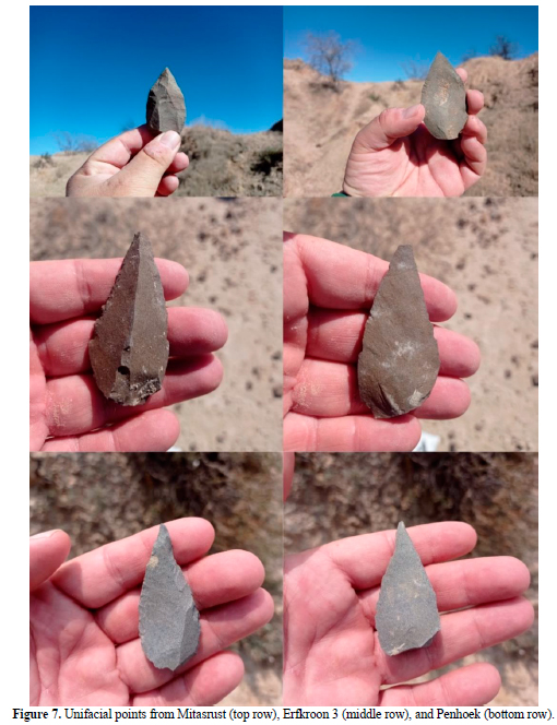
Area 1 was identified following the bottom of the main donga drainage channel from the river to its inception, after locating many artefacts embedded in the channel fill that include a big platform core used to produce blades and Levallois points. This area is connected with the main donga through a short and deep tributary gully that erodes a surface with high gradient slopes. Two clusters were identified in this area, both deep into the Lower Grey Bed (2.5 to 3 m): one (C1) within a gravel bed, and a second cluster (C2) embedded within finer sediments. C1 exhibits some diagnostic MSA artefacts (two Levallois cores, a unifacial point, and flakes with faceted platforms) (Fig. 7). C2 includes an MSA unifacial point associated with some vertebrae of a medium-sized mammal at the base of a recent erosional channel (SOM 1 Figs 13-14).
Area 2 is located 110 m to the west of Area 1 and includes three clusters in the Lower Grey Bed. The first two clusters (C1 & C2) are eroded domes with ridges, whereas C3 is a flat step with an accumulation of clasts laterally sectioned by a gully. C1 shows an accumulation of flakes linked to a platform core with no clear diagnostic features. The presence of quartzite is remarkable in this cluster, as it is not a rock found in the geology of the region (Holmes & Barker 2006). C2 includes some non-diagnostic flakes, two unifacial points, a Levallois core and some blades of clear MSA technology, as well as a tool on a blade with alternating retouch, and a borer-like tool with denticulated edges, similar to artefacts found at Erfkroon and Waterval (Trower 2010; Bousman et al. 2023). An equid molar was the only faunal remain in the cluster. Some of the flakes in C2 were found stuck into the sections of the side channels that erode the large dome of Lower Grey sediment. Finally, C3 includes several diagnostic MSA artefacts, such as two Lovedale points (Fig. 6), a sidescraper (on core), and blade/bladelet fragments (SOM 1 Figs 15-18).
Western catchment
Uitvlug-Wes: Uitvlug-Wes features a large donga system where most of the eroded surface is covered by vegetation and only one fifth is exposed terrain. We identified four drainages, of which the two to the east appear to be barely active in terms of erosion as they are covered by thick vegetation, and the two to the west are clearly active during the rainy season due to the absence of vegetation. In this second portion, the westernmost drainage features a high profile (up to 5 m in places) characterised by the Lower Grey Bed-Red Palaeosol-Upper Grey Bed sequence on top of Ecca shale bedrock, including water-worn hornfels nodules at the surface. In this area we found non-diagnostic flakes on the surface of the section slopes that are difficult to correlate with any sediment bed. The second drainage coming from the west shows greater maturity in its erosion, as indicated by massive sand deposits that fill the gullies. Except for two examples of weathered Levallois points associated with the base of the Lower Grey Bed and calcium carbonate nodules (1.2 to 1.4 m of visible thickness), only non-diagnostic artefacts were found in this area (A1) (SOM 1 Fig. 19). The easternmost donga features a small barren area (A2) next to the river where a single dolerite flake was found on the surface of a convex slope of the Lower Grey Bed with calcium carbonate nodules, underlying a remnant of the Red Palaeosol (SOM 1 Table 5, Fig. 20).
Georgina: Georgina 1 is small and includes two areas with artefacts (SOM 1 Table 6). Area 1 is located in the eastern portion of the drainage and produced non-diagnostic artefacts on a convex slope at the contact between a Lower Grey Bed and overlying Red Palaeosol. This small cluster includes seven non-diagnostic flakes with unidirectional scars, a small blade, and an inclined core. In the drainage to the west, close to the edge of the donga, we found an artefact (A2) stuck into a Lower Grey Bed with calcium carbonate nodules, on top of which a Red Palaeosol is visible on the opposite side of the donga. Between these areas and closer to the riverbed, we found an accumulation of fossil bones within a brown alluvium including many anatomical parts of different vertebrates, probably related to a carnivore den. Georgina 2 is a shallow gully almost completely covered by vegetation and with a yellow sand infill devoid of artefacts.
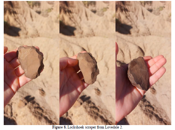
Lovedale: The Damvlei and Lovedale dongas have produced LSA and MSA occupations, respectively (Richard et al. 2022, 2023; Wroth et al. 2022; Toffolo et al. 2023). The Lovedale 2 donga, 1 km downstream of Lovedale 1 on the same side of the river, is a small erosional feature characterised by high crests and ridges that match the Lower Grey Bed-Red Palaeosol-Upper Grey Bed sequence at Erfkroon. The donga features isolated MSA artefacts and faunal remains throughout its extension, one cluster of ungulate faunal fragments including several teeth, one cluster of MSA artefacts with blades and fragments of unifacial points and two clusters of LSA artefacts and vertebrate fauna, including ungulate teeth (density=0.041) (SOM 1 Tables 7, 20). The LSA clusters are located in the Upper Grey Bed although in a secondary context and can be assigned to the Lockshoek industry based on the occurrence of large endscrapers (Fig. 8; SOM 1 Fig. 21). These clusters, separated by only a few metres, may be part of the same occupation.
Abrahamskraal: To the west of Lovedale 2, the same donga system falls within the neighbouring farm Abrahamskraal and is hereby called Abrahamskraal 4. This larger drainage features a small yet diagnostic assemblage of MSA artefacts divided in two areas. Area 1, with two flakes and a Levallois point, is located in a deep gully running perpendicular to the river. The pieces were found at the surface of a dome in the Lower Grey Bed with calcium carbonate nodules, stratigraphically beneath a Red Palaeosol and Upper Grey Bed. Area 2 presents two Levallois cores and one flake at the base of a high bluff next to the river (SOM 1 Table 9). The sedimentary context is consistent with the Lower Grey Bed. Further to the west, on the same side of the Modder, three smaller drainages that are part of the same donga were surveyed near the Abrahamskraal homestead. Abrahamskraal 1, 2, and 3 exhibit a relatively small surface area that does not match the stratigraphic succession of Erfkroon, but rather the one observed at Lovedale 1 in which the MSA occupation occurs in a bed of light grey-bluish sandy clay under a Holocene brown silty sand (Wroth et al. 2022). We observed only a few lithic artefacts of both MSA and LSA technology and faunal remains (including fragments of ungulate teeth) (SOM 1 Table 8). However, one of the MSA artefacts is a broken and weathered Lovedale point characterised by the typical bifacial trimming of the base (Fig. 6).
To the west of Abrahamskraal 4, Abrahamskraal 5 includes three drainages of which we could survey only the easternmost, since the other two are part of a game enclosure. The donga we surveyed features two archaeological areas. Area 1 is a small occurrence of only two artefacts in primary depositional context that include an MSA unifacial point and a blade or flake stuck into the section (SOM 1 Fig. 22). The exiguous cluster is nevertheless important if we consider its primary position and diagnostic character of the tools. Area 2 is placed 140 m to the southeast of Area 1. This area is one of the richest MSA areas discovered in our survey with up to 40 artefacts including many diagnostic MSA tools and cores. We divided this area into two clusters due to its richness. C1 includes a Levallois recurrent centripetal core on flake, a L déjeté sidescraper, a Levallois flake, and three Levallois points (Fig. 9; SOM 1 Figs 23-25). C2 includes a unipolar Levallois or high-backed platform core, two blades with faceted butts, two Levallois flakes, a small Levallois point and several sets of flakes that could possibly come from some knapping episodes (SOM 1 Tables 10, 21 & Figs 26-28). We did not find faunal remains, but the scatters of flintknapping waste and formal tools suggests the possibility of ephemeral occupations. The artefacts were found in a light grey-bluish sandy clay with calcium carbonate and iron oxide nodules, not capped by any later sediment, which could be consistent with the stratigraphic sequence at Lovedale 1.
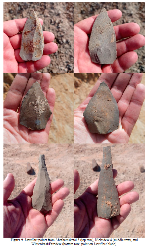
Nielsview: The Nielsview farm includes four dongas featuring the Lower Grey Bed-Red Palaeosol-Upper Grey Bed-Brown Palaeosol succession. Nielsview 1, 2, and 3 produced only a handful of non-diagnostic artefacts, except for a Lockshoek scraper at the boundary between the Upper Grey Bed and Brown Palaeosol. Nielsview 4 is the most developed of the dongas in this property in terms of erosional incision, and the richest in artefacts, although mainly comprising isolated and non-diagnostic finds sometimes accompanied by bone fragments and ungulate teeth (SOM 1 Figs 29-30). One cluster, found in the upper portion of the Lower Grey Bed close to the boundary with the overlying Red Palaeosol, included a Levallois point (Fig. 9) and a platform core of clear MSA technology (SOM 1 Tables 11, 22).
Thorndale: Thorndale exhibits a large zone to the north covered by the Red Palaeosol, whereas to the south it only preserves the Lower Grey Bed. Next to the northern drainage there is a small archaeological area (A1) with two large dolerite cobbles stuck into the Red Palaeosol and some flakes and a sidescraper located on the surface of the nearby dome-shaped ridges. Another area (A2) is found to the south of the previous and shows several low, well-rounded mounds or domes of the Lower Grey Bed with rounded dolerite pebbles and calcium carbonate nodules, including a large number of poorly preserved MSA artefacts. The latter were found on the surface of mounds and into the reworked sediments at the bottom of the drainage gully. The cluster nevertheless includes some large blades, flakes and a Levallois point that clearly indicate an MSA site, although of secondary context (SOM 1 Tables 12, 23).
Erfkroon: Erfkroon 1 and 3 belong to the eponym farm, and the former has produced several MSA and LSA occupations, including some of the very few early LSA and Robberg assemblages in the Free State (Bousman et al. 2023), whereas Erfkroon 2 and 4 belong to the Edelweiss farm.
Erfkroon 2 features a complete stratigraphic sequence that matches that of Erfkroon 1. From top to bottom, one can easily discern an aeolian sand cap, the Brown Palaeosol (0.5 to 0.6 m), the Upper Grey Bed (1.7 to 1.9 m), the Red (van den Berg) Palaeosol (0.4 to 0.6 m), and a thick Lower Grey Bed (>5 m). The portion of the sequence down to the Red Palaeosol is mainly confined to the edges of the donga, whereas its central portion has exposed deep incisions into the Lower Grey Bed. The main drainage channel runs east-west creating deep sections, with bluffs up to 5 m in height. The northern side of the donga bottom (A1) exhibits isolated MSA artefacts (density 0.018) that include blades and a Levallois point characterised by rounded edges indicative of some degree of transportation.
The main archaeological area is located to the south of the drainage channel and exhibits a greater density of artefacts and assemblages of faunal remains (A2). The latter are mainly ungulate teeth of Florisian species, such as Megalotraguspriscus (Brink et al. 2016). A2.1 comprises 12 artefacts on a surface of around 140 m2 (density=0.08) and includes several diagnostic MSA artefacts with weathered and rounded surfaces embedded in the Lower Grey Bed (SOM 1 Fig. 31). A2.2 is located to the south of A2.1 at the boundary between Lower Grey Bed and Red Palaeosol. This cluster contains numerous artefacts (74) spread onto a relatively small surface area of around 150 m2 (density=0.49). Flakes and flake fragments with unipolar directions in their scars and flat single platforms represent the largest component of the assemblage. There are also some blades, a Levallois-like core with a single platform and a wide final scar, and a small Levallois-like point with flat platform and some dolerite cobbles. Along this accumulation of knapping scatter, we also identified a scaled piece that could be related to an early LSA industry (SOM 1 Fig. 32). A2.3, located at the top of dome-shaped ridges in the Lower Grey Bed, is characterised by only a few artefacts and several faunal remains in primary depositional context. In this case, the accumulation of artefacts has a low density (0.037) but noteworthy is the association of fauna and lithics related to the final steps of the chaine opératoire (SOM 1 Tables 13, 24). The artefacts include a unifacial point with regular to invasive retouch, two thin and curved blades, and a core exploited in several directions with a final wide scar worked in the way of a Levallois core, which could also be classified as a platform, high-backed core or inclined core (SOM 1 Fig. 33).
Erfkroon 4 is another large and deeply incised donga featuring the same stratigraphic sequence as Erfkroon 1, which however produced only a few and isolated LSA artefacts, possibly related to the Lockshoek industry.
Erfkroon 3 comprises three drainages where we identified a poorly preserved archaeological area in the central one (A1), three areas in the northern one (A2, A3, and A4) and three areas in the southern one (A5, A6, and A7) (SOM 1 Tables 14, 25). A1, in the middle part of the central drainage, presents the Lower Grey Bed underlying the Red Palaeosol, the latter visible only near the edge of the donga, ~400 m from the riverbed. This area includes isolated and rolled MSA artefacts embedded in a palaeodonga channel facies with small gravels.
The northern drainage features a spring at the edge of the donga near to which we identified numerous artefacts (A2) grouped in three clusters. C1 includes flakes and flake fragments at the base of a bluff laterally eroded by a channel fed by the nearby spring (SOM 1 Fig. 34). C2 is located on top of a flat step between C1 and C3 and includes nine artefacts associated with many cobbles of different rock types (SOM 1 Fig. 35). C3 also contains cobbles, as well as MSA artefacts: blades (with regular retouch in one case), a unifacial point and a bipolar core. This cluster occurs on the top of a flat, inclined surface (SOM 1 Fig. 36). All clusters occur in the Lower Grey Bed, which is capped by the Red Palaeosol visible at the spring. Area 3 is located 30 m to the west of Area 2 in a similar sedimentary context. However, we decided to separate this small accumulation of artefacts (13) due to the presence of a gully that interrupts the stratigraphic continuity (SOM 1 Fig. 37). Only a unifacial point with regular retouch seems diagnostic of an MSA occupation (Fig. 7). A4 is located a few metres to the north of A3 from which it is separated by a gully, and it occurs on the surface of a low ridge in the upper portion of the Lower Grey Bed. The lithic assemblage of this area features the use of some dolerite cobbles, and it comprises a group of flakes and flake fragments similar in technology and size (unipolar, single platforms, medium to small sized) that suggest a single or short episode of knapping (SOM 1 Fig. 38).
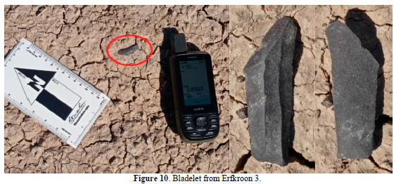
A5, in the southern drainage, is a cluster of microlithic artefacts found at the surface of the Upper Grey Bed, next to an eroded bluff of brown sands. The assemblage is characterised by many bladelets and endscrapers, with a clear attribution to an LSA occupation. The standardised aspect of some bladelets suggests high levels of control of the reduction process: single (flat) platforms, parallel edges and ridges, thin sections, and slightly curved profiles (Fig. 10). This regularity could be linked to knapping techniques such as indirect percussion, proposed for some Robberg industries, although freehand percussion has also been proposed for bladelet production during this period (Porraz et al. 2016). Only two small endscrapers are documented as formal tools at this area (SOM 1 Fig. 39). A6 is located 100 m to the north of A5, at the contact between the Red Palaeosol and Upper Grey Bed. We identified two clusters at the top of eroded ridges, with the first (C1=26 pieces) probably linked to a single knapping episode of a high-backed (or semi-conical) platform core, which occurs with associated unipolar elongated flakes (SOM 1 Fig. 40). The second cluster (C2=22 pieces) shows a greater diversity in the technology and the weathering of the artefacts found there. Several patina colours occur on a variety of artefacts that include a Levallois point, many non-diagnostic flakes, dolerite cobbles, and a scaled piece formally attributable to an early LSA industry (SOM 1 Fig. 41). Area 7 is located 70 m to the north of Area 6 and includes only three lithic artefacts and the vertebra of a medium-sized ungulate at the contact zone between the Upper Grey Bed and Brown Palaeosol (SOM 1 Fig. 42).
Penhoek: Penhoek comprises a main drainage of southeast-northwest direction and two minor drainages of southwest-northeast direction. We identified one archaeological area in each drainage. The stratigraphic sequence exposed by the donga includes the Red Palaeosol, visible at its edge, and the Lower Grey Bed underneath, in which all the artefacts were found (SOM 1 Tables 15, 26).
Penhoek A1 presents two separate clusters. The artefacts (45) are spread onto the surface of convex, eroded ridges of the Lower Grey Bed with calcium carbonate nodules. C1 includes dolerite cobbles, non-diagnostic flakes and flake fragments, some blades and two denticulates made on Levallois flakes. The blades (two of them crested) in some cases exhibit thin and curved profiles (SOM 1 Fig. 43). C2 contains flakes and flake fragments, three blades, and a narrow-sided platform core (SOM 1 Fig. 44). Based on the lithics, the entire area likely comprises one or more MSA occupations. The denticulates and the blades with curved and thin profile also suggest a possible association to a pre-Still Bay technocomplex (i.e., before the Still Bay and after the early MSA), even if the nearby site of Florisbad shows a slightly different composition of its pre-Still Bay assemblage, with less formal tools compared with other contemporary sites (Kuman et al. 1999; Brink & Henderson 2001; Henderson 2001).
A2 is in the middle drainage, where extensive erosion has produced dome-shaped ridges and high crests. The sediment exposed in this area comprises a thick (>3 m) layer of the Lower Grey Bed with calcium carbonate nodules capped in places by brown sand. Artefacts occur on the sides of a large sediment dome laterally cut by two gullies. The upper part of this dome features MSA artefacts (two blades, two unifacial points, a sidescraper; Fig. 7) in association with faunal remains including several cranial fragments, some molars, and some epiphysis and diaphysis fragments probably related to mid-sized ungulates. The bluffs created by the gullies are also characterised by many bones and bone fragments (including ribs and vertebrae) and a few lithic artefacts such as flakes and blades (SOM 1 Fig. 45). The final stages in the chaine opératoire of the artefacts, linked to the varied representation of anatomical parts of the fauna, suggest temporary occupations related to hunting or carcass processing.
A3 is a wide and deeply eroded portion of the westernmost drainage. As in Area 2, the slopes created by the erosion of the Lower Grey Bed exhibit high gradients. In this case, the sedimentary facies related to palaeodonga channels are more frequent and include rolled artefacts and bone fragments embedded in sandy sediment with calcium carbonate nodules characterised by horizontal fabric. The few, poorly preserved artefacts nevertheless include some clearly attributable MSA artefacts such as flakes with faceted butts, a Levallois point, and one elongated overshot flake with centripetal removals.
Winterdraai/Fairview: Winterdraai/Fairview is divided into two portions because it belongs to two different farms, with Fairview to the east and Winterdraai to the west. We identified three archaeological areas spanning the Lower Grey Bed-Red Palaeosol-Upper Grey Bed sequence, clearly visible in high profiles (SOM 1 Tables 16, 27). Isolated MSA artefacts, such as Levallois and unifacial points were found at different locales at the bottom of these sections, where the Lower Grey Bed is visible, although it is not possible to determine the occurrence of an actual site (SOM 1 Fig. 46). A1 is an LSA site located at the edge of the donga, at the base of an eroded bluff of the Upper Grey Bed. A3 is located at the southernmost part of the eroded surface of this donga, within the Lower Grey Bed. Despite the presence of some MSA artefacts, their poor preservation as well as the sediment composition, mostly yellow sands, indicate a secondary context formed in recent times (SOM 1 Fig. 47).
A2 is located on the left side of the main drainage channel of the donga and features an accumulation of artefacts and dolerite cobbles associated with a shallow and eroded crest of Red Palaeosol. Some of the artefacts were found on the surface of the ridges of this crest, whereas many others were found at the base of the ridges and at the contact with the underlying ridges of the Lower Grey Bed. We identified three clusters to facilitate artefact counts, although the presence of isolated artefacts between clusters suggests the possibility of a single assemblage. C1 and C2 include many flakes and flake fragments with unidirectional scars associated with two high-backed platform cores, which seem to be the result of one or two separate knapping episodes (SOM 1 Figs 48-49). The platforms are mostly produced by a single facet and one of the cores suggests the removal of Levallois-like end products (triangular flakes). C3 includes a large blade, a large unifacial point on a Levallois blade (Fig. 9), and some Levallois flakes linked to a dolerite cobble. Compared to the artefacts found in C1 and C2, probably related to short episodes of occupation and linked to the Red Palaeosol, the C3 artefacts have clearer MSA technological features, and its spatial association with the other clusters could be only circumstantial (SOM 1 Fig. 50). Its position, on an eroded surface of the Lower Grey Bed next to the base of the erosional crests of the Red Palaeosol, would seem to corroborate this interpretation.
Slagkraal: Slagkraal is a small and shallow donga that features the Red Palaeosol, close to the edge of the donga with low bluffs of 0.5 to 0.7 metres, and the Lower Grey Bed outcropping at the bottom of the drainage. Lithic artefacts were found on this surface, more precisely an assemblage of three short and thick flakes presumably obtained from the exploitation of inclined cores, which suggest a possible MSA chronology.
Loogkop: Loogkop features only one significant locale. This single cluster comprised an accumulation of seven endscrapers, a sidescraper, some flakes, and an inclined core produced by recycling an older core with brown patina. The entire assemblage could be related to an LSA occupation, probably Lockshoek. The stratigraphy, in this case, does not allow placing the cluster in a relative chronology since the sedimentary context, composed of grey sediments possibly consistent with the Upper Grey Bed, is capped by a thin layer of brown sands. An abandoned quarry next to the road bordering the property contains large hornfels cobbles that could have been an attracting factor for the occupation of this area. Other hornfels outcrops are known at Erfkroon 1 and Damvlei, but none of these feature artefacts. Based on the polished cortex of some cores found at Lovedale 1, hornfels cobbles were probably sourced from the riverbed (Wroth et al. 2022).
5. Discussion
The surveyed dongas include 43 areas of archaeological interest along the Modder River, thereby multiplying threefold our knowledge of the human occupation of the area during the late Quaternary. Three main results become immediately apparent: 1) MSA and LSA technocomplexes are represented throughout the catchment, although actual sites characterised by large assemblages occur only at specific localities, which are Waterval, Kranskraal, and Mitasrust in the eastern catchment and Lovedale, Abrahamskraal, Erfkroon, Penhoek, and Winterdraai/Fairview in the western catchment; 2) the lithic assemblages that we found are confined to the Late Pleistocene and Holocene, thus confirming previous observations that the terraces of the Modder do not preserve Early and Middle Pleistocene sediments (Toffolo 2024 and references therein); 3) except for Abrahamskraal, all of the sedimentary contexts bearing artefacts are consistent with the allostratigraphic succession established at Erfkroon, which highlights the relevance of the Orangia terrace for the entire catchment. In the following sections, we discuss the results of the survey based on the Upper Grey Bed-Red Palaeosol-Lower Grey Bed framework.
Upper Grey Bed
The Upper Grey Bed yielded several LSA assemblages all along the Modder. The main LSA occurrences that we identified are Waterval A3, Lovedale 2, Erfkroon 3 A5, Winterdraai/Fairview A1 and Loogkop, although isolated artefacts belonging to the Lockshoek industry were observed in almost all dongas, such as concavo-convex scrapers with scaled retouch, large endscrapers, and adzes, highlighting the importance of this early Holocene technocomplex in the region. These tools were found in the clusters at Lovedale 2 and Loogkop. Waterval A3 produced many pieces in opaline, fossilised wood, agate, chert, and other cryptocrystalline silicates (sourced from the riverbed; e.g., Sampson 1968, 1970) including small flakes and some microliths associated with hornfels artefacts such as scrapers and bladelet cores, which appear to be part of the Wilton technocomplex. Only a few bladelets were found there, although Trower (2010) found them with more frequency during his survey. At Erfkroon 3 A5, on the contrary, we found many bladelets but no bladelet core and also some scrapers and non-diagnostic flakes in varied raw materials but with a clear predominance of hornfels. The presence of the bladelets, with unfaceted single platforms and parallel ridges and edges suggests a possible association with the Robberg technocomplex, which would be consistent with results from Area K at Erfkroon 1 (Palmison 2014; Bousman et al. 2023). If confirmed by absolute dating, which is currently not available, the existence of this Robberg assemblage would require a reconsideration of human presence in the grasslands of the western Free State during Marine Isotope Stage (MIS) 2 (Mitchell 2017).
Red Palaeosol
The archaeological areas associated with the Red Palaeosol are Palmietfontein 2, Georgina A1, Thorndale A1, Erfkroon 2 A2.2, Erfkroon 3 A4 and A6, Winterdraai/Fairview A2, and Slagkraal A1. This is a significant group of sites if we consider that the average thickness of this deposit and its chronological range are considerably less than those proposed for the Upper Grey and Lower Grey Beds. However, only half of these occurrences (Erfkroon 2 A2.2, Erfkroon 3 A4 and A6, and Winterdraai/Fairview A2) deserve a deeper analysis, since the others comprise small clusters of artefacts, and only Winterdraai/Fairview showed potential for in situ artefact recovery. Nevertheless, taking into consideration all the assemblages that we found, we can identify repetitive technological traits across these occupations. Besides a few formal tools that include scrapers and two scaled pieces (Erfkroon 2 A2.2 and Erfkroon 3 A6), most of the artefacts are sets of flakes with unidirectional scars and high-backed platform cores exploited using hard hammerstones - perhaps the small dolerite 'balls' that usually appear in association with these cores and flakes. Some of the cores show a final triangular scar and Levallois-like products but plain, unfaceted platforms were also observed, for instance short and thick blades or points, found in some archaeological areas such as Erfkroon 2 A2.2.
The overall impression with the scatters of flakes and cores is that many of the artefacts could refit and be the result of place provisioning (sensu Mackay et al. 2014) rather than individual provisioning. It is difficult to assign the assemblages in the Red Palaeosol to specific technocomplexes due to their different features (e.g., appearance of Levallois-like products but predominance of unfaceted platforms), although they could be consistent with either the post-Howiesons Poort or final MSA (sensu Lombard et al. 2022), or perhaps with the early LSA. The early LSA assemblages at Erfkroon 1 are characterised by bipolar pieces made on large flakes (Bousman et al. 2023). These pieces are scarce in our survey, but we found at least two similar examples, one at Erfkroon 2 A2.2 and one at Erfkroon 3 A6, which appear to derive from the Red Palaeosol. This deposit seems to hold potential to further explore the MSA/LSA transition in South Africa, which currently is poorly understood (Bousman & Brink 2018; Bader et al. 2022).
Lower Grey Bed
Most of the archaeological areas identified during our survey derived from, or were found embedded in, the Lower Grey Bed. Several of these (Palmietfontein 1 A1, Uitvlug-Wes A1, Thorndale A2, Erfkroon 2 A1 and A2.1, Erfkroon 3 A1, and Penhoek A3) were deposited in high-energy water environments such as channels, and as a result the artefacts are rolled or weathered. These assemblages are unfortunately less significant given the possibility of long-distance transport, even though they include diagnostic MSA artefacts and sometimes also fauna as at Penhoek A3. Other areas, on the contrary, produced well-preserved artefacts but in very small quantities: Watervalsdrift, Uitvlug-Wes A2, Abrahamskraal 4 A1 and A2, Lovedale 2 A1, Nielsview 4, and Erfkroon 3 A3 and A7. The most informative areas for the study of the MSA, which can be considered as sites based on their high density of artefacts, include Waterval A1 and A2, Mitasrust A1 and A2, Abrahamskraal 5 A1 and A2, Erfkroon 2 A2.3, and Penhoek A1 and A2. All of them contain abundant MSA artefacts, except for Erfkroon 2 A2.3 and Penhoek A2 that show lower densities of stone tools, and all of them contain associated fauna and lithics with the exception of Waterval A1 and Abrahamskraal 5, where only artefacts were found. Furthermore, Mitasrust A2, Abrahamskraal 5 A1, and Erfkroon 2 A2.3 exhibit artefacts stuck in sections created by gully erosion, and thus hold potential for the excavation of artefacts in situ.
With regard to lithic technocomplexes, we are somewhat limited in our interpretation by the lack of common diagnostic features defining pre-Still Bay assemblages in the South African interior (Wurz 2013; Porraz et al. 2018; Pazan et al. 2022), given that later technocomplexes such as the Still Bay and Howiesons Poort are absent in the western Free State and in our sample. Similarly, we can exclude on typological grounds the early MSA technocomplex (~300-120 ka), based on the local example of Florisbad (Kuman et al. 1999). Therefore, we are left with assemblages that probably span MIS 5 (~130-71 ka) (Lisiecki & Raymo 2005). The occurrence of Lovedale points at Waterval, Mitasrust, and Abrahamskraal lends support to this interpretation, as this type of point was dated to ~77-69 ka at Lovedale (Wroth et al. 2022) and to ~96-64 ka at Rose Cottage Cave (Harper 1997; Valladas et al. 2005; Pienaar et al. 2008), and it was also found at Kranskraal (van Hoepen 1932) and Vlakkraal (Wells et al. 1942). The presence of Levallois cores (recurrent centripetal and unidirectional convergent), large Levallois flakes, Levallois and unifacial points, and Lovedale points at Waterval, Mitasrust, and Abrahamskraal 5 supports the contemporaneity of the assemblages. In addition, the light grey-bluish colour of the sedimentary context in which these assemblages are embedded appears similar to Sedimentary Unit 4 at Lovedale, which marks the beginning of the MSA occupation at the site (Richard et al. 2022; Wroth et al. 2022). Considering the quantity and variety of artefacts stuck in bluffs (primary depositional context) together with faunal remains, and the occurrence of Lovedale points, we conclude that Mitasrust is the most promising site for the characterisation of the Lower Grey Bed in the eastern portion of the Modder catchment, which remains undated (Rossouw 2006). Absolute dating of the nearby Kranskraal donga would further contribute to the refinement of the MSA chronology of the region.
Surveys in southern Africa
Other surveys conducted in South Africa or in nearby countries such as Botswana have shown a positive correlation between artefact densities and access to raw materials and proximity to water (Shaw et al. 2019; Ecker et al. 2023; Staurset et al. 2023; Will et al. 2024). Both resources seem to be extremely important for the occupation of the Karoo during the Earlier Stone Age, whereas the MSA occupations show more flexibility in the use of local raw materials or transport of knapped items up to 50 km from the outcrops (Hallinan 2022).
The dominant fine-grained sediments of the Grassland Biome differ completely from the Karoo landscape, where the rocky surface shows high amounts of hornfels exposed by erosion with a near-continuous presence of knapped artefacts (Sampson 1985; Hallinan 2022). Perhaps for this reason it is more difficult to determine the origin of the raw materials knapped at the MSA sites. Even if hornfels outcrops have been found at Loogkop, Damvlei, and Erfkroon, we see many macroscopic differences in the quality of their fracture compared with the hornfels used in most artefacts from these MSA sites. Other surveys in the area have found hornfels outcrops more than 25 km away from the Modder (e.g., Orton 2021), which could be related to the raw materials exploited at the MSA sites of the Orangia terrace, but further petrological or geo-chemical analyses are needed to confirm the provenance of the latter. The density of artefacts and faunal remains is relatively low at all surveyed sites when compared to other areas such as the Jojosi dongas (Will et al. 2024), the Tankwa Karoo (Hallinan 2022), or the Doring River (Shaw et al. 2019), where concentrations of hundreds of artefacts were counted over a few square metres. As we have stated, some of these areas are directly related to outcrops or to rocky and arid surfaces exposed by deflation and they are not easily comparable with our case study. Other examples like the pan fields in the Tsabong area (Ecker et al. 2023) and the Makgadikgadi Basin (Staurset et al. 2023), or the Virginia-Theunissen area (de Ruiter et al. 2011) seem to provide better parallels. The latter example, with donga systems incising the alluvial terraces of the Vet and Sand Rivers offers a direct comparison with the Modder, although no artefact counts are available.
The majority of MSA sites documented in the Lower Grey Bed show high rates of formal tools (including unifacially retouched or unretouched Levallois points, blades, and scrapers) compared to the lower rates of cores and informal non-diagnostic flakes. This feature fits well with an individual provisioning pattern (Mackay et al. 2018) whereby human groups in the area would take with them a kit of largely utilitarian tools that would be subjected to occasional trimming as seen at Lovedale (Wroth et al. 2022) or Erfkroon (Bousman et al. 2023). Both residential mobility strategy camps and logistical mobility strategy extraction camps could produce similar accumulations of high amounts of formal tools, but they are hardly discernible (Barton & Riel-Salvatore 2014). On the contrary, occupations in the Red Palaeosol, with higher proportions of unretouched flakes and cores and with higher amounts of cortex and possible refits, seem more likely to be the result of place provisioning, with on-site knapping actions. A similar change from individual to place provisioning has been determined for the Winter Rainfall Zone, from the MIS 5 Still Bay industries to the post-Howiesons Poort (Mackay et al. 2018). The allostratigraphy of the Modder River could be a valuable context to determine a shift in the occupation patterns during the late MSA.
6. Conclusions
The Modder River has been the subject of prehistoric research since the 1920s, showing its potential for understanding the MSA and LSA records of the central interior of South Africa. What was lacking until recently was a stratigraphic and chronological reference framework to provide context to archaeological occurrences. Our survey, carried out based on such a framework, has facilitated a deeper chronological understanding of the numerous archaeological areas that we found, now organised for the entire Modder catchment. While additional absolute dating is necessary in the eastern portion of the catchment in order to confirm stratigraphic correlations with its western portion, the presence of a time-constrained lithic type like the Lovedale point throughout the basin, and in the highlands of the eastern Free State, seems to indicate the existence of a local cultural tradition during MIS 5. This may contribute to the definition of technocomplexes in the interior of South Africa during this time period, and lead to a better understanding of human presence in these open interior landscapes.
Acknowledgements
The research leading to this article was conducted under the auspices of the National Museum Bloemfontein. It was funded by the European Union. Views and opinions expressed are however those of the authors only and do not necessarily reflect those of the European Union or the European Research Council Executive Agency. Neither the European Union nor the granting authority can be held responsible for them. This work is supported by a European Research Council grant (PEOPLE, n. 101039711, DOI: 10.3030/101039711). Michael Toffolo was also supported by the grant RYC2021-030917-I funded by the MCIN/AEI/10.13039/501100011033 and by the "European Union NextGenerationEU/PRTR". The 2022 fieldwork expenses were covered by a grant from the French Institute in South Africa (IFAS) to Maïlys Richard, titled "Exploring potential Middle Stone Age occupations in the interior of South Africa". The authors wish to thank Jacob 'Japie' Maine for his assistance during fieldwork and the farm owners for their permission to access properties. We thank also C. Britt Bousman for the shapefile of the Modder catchment.
Supplementary online material
Cuartero Monteagudo et al. Supplementary Online Material File 1
References
Bader, G.D., Cable, C., Lentfer, C., et al. 2016. Umbeli Belli Rock Shelter, a forgotten piece from the puzzle of the Middle Stone Age in KwaZulu-Natal, South Africa. Journal of Archaeological Science: Reports, 9: 608-622. https://doi.org/10.1016/j.jasrep.2016.08.038 [ Links ]
Bader, G.D., Mabuza, A., Price Williams, D., et al. 2022. Rethinking the Middle to Later Stone Age transition in southern Africa - A perspective from the highveld of Eswatini. Quaternary Science Reviews, 286: 107540. https://doi.org/10.1016/j.quascirev.2022.107540 [ Links ]
Barker, C.H. 2011. Utilising published data for DTM construction and drainage basin delineation in the Modder River catchment, Free State, South Africa. South African Geographical Journal, 93: 89-103. https://doi.org/10.1080/03736245.2011.565150 [ Links ]
Barton, C.M. & Riel-Salvatore, J. 2014. The formation of lithic assemblages. Journal of Archaeological Science, 46: 334-352. https://doi.org/10.1016/j.jas.2014.03.031 [ Links ]
Bergström, A., Stringer, C., Hajdinjak, M., et al. 2021. Origins of modern human ancestry. Nature, 590: 229-237. https://doi.org/10.1038/s41586-021-03244-5 [ Links ]
Bousman, B., Brink, J., Rossouw, L., et al. 2023. Erfkroon, South Africa. In: Beyin, A., Wright, D.K., Wilkins, J. & Olszewski, D.I. (eds) Handbook of Pleistocene Archaeology of Africa: Hominin Behavior, Geography, and Chronology: 1431-1450. Cham: Springer International Publishing. https://doi.org/10.1007/978-3-031-20290-2_92 [ Links ]
Bousman, C.B. & Brink, J.S. 2018. The emergence, spread and termination of the Early Later Stone Age event in South Africa and southern Namibia. Quaternary International, 495: 116-135. https://doi.org/10.1016/j.quaint.2017.11.033 [ Links ]
Bouzouggar, A., Barton, N., Vanhaeren, M., et al. 2007. 82,000-year-old shell beads from North Africa and implications for the origins of modern human behavior. Proceedings of the National Academy of Sciences, 104: 9964-9969. https://doi.org/10.1073/pnas.0703877104 [ Links ]
Brink, J.S. 1987. The archaeozoology of Florisbad, Orange Free State. Memoirs van die Nasionale Museum, Bloemfontein, 24: 1-151. [ Links ]
Brink, J.S. 1988. The taphonomy and palaeoecology of the Florisbad spring fauna. Palaeoecology of Africa and the Surrounding Islands, 19: 169-179. [ Links ]
Brink, J.S. 1994. An ass, Equus (Asinus) sp., from the late Quaternary mammalian assemblages of Florisbad and Vlakkraal, central southern Africa. South African Journal of Science, 90: 497-500. https://hdl.handle.net/10520/AJA00382353_7812 [ Links ]
Brink, J.S. 2016. Faunal evidence for a mid- and late Quaternary environmental change in southern Africa. In: Knight, J. & Grab, S.W. (eds) Quaternary Environmental Change in Southern Africa: Physical and Human Dimensions: 284-305. Cambridge: Cambridge University Press. https://doi.org/10.1017/CBO9781107295483.018 [ Links ]
Brink, J.S. & Lee-Thorp, J.A. 1992. The feeding niche of an extinct springbok, Antidorcas bondi (Antelopini, Bovidae), and its palaeoenvironmental meaning. South African Journal of Science, 88: 227-229. https://hdl.handle.net/10520/AJA00382353_9466 [ Links ]
Brink, J.S. & Henderson, Z.L. 2001. A high-resolution Last Interglacial MSA horizon at Florisbad in the context of other open-air occurrences in the central interior of southern Africa: An interim statement. In: Conard, N.J. (ed.) Settlement Dynamics of the Middle Paleolithic and Middle Stone Age: 1 -20. Tübingen: Kerns Verlag. [ Links ]
Brink, J.S., Berger, L.R. & Churchill, S.E. 1999. Mammalian fossils from erosional gullies (dongas) in the Doring River drainage, central Free State, South Africa. In: Berger, C., Manhart, H., Peters, J., et al. (eds) Historia Animalium ex Ossibus: Beiträge zur Paläoanatomie, Archäologie, Ägyptologie, Ethnologie und Geschichte der Tiermedizin: Festschrift für Angela von den Driesch: 79-90. Rahden/Westfalen: Verlag Marie Leidorf. [ Links ]
Brink, J.S., Bousman, C.B. & Grün, R. 2016. A reconstruction of the skull of Megalotragus priscus (Broom, 1909), based on a find from Erfkroon, Modder River, South Africa, with notes on the chronology and biogeography of the species. Palaeoecology of Africa, 33: 71-94. https://doi.org/10.1201/b19410 [ Links ]
Brooks, A.S., Yellen, J.E., Potts, R., et al. 2018. Long-distance stone transport and pigment use in the earliest Middle Stone Age. Science, 360: 90-94. https://doi.org/10.1126/science.aao2646 [ Links ]
Burrough, S.L., Thomas, D.S.G., Allin, J.R., et al. 2022. Lessons from a lakebed: Unpicking hydrological change and early human landscape use in the Makgadikgadi Basin, Botswana. Quaternary Science Reviews, 291: 107662. https://doi.org/10.1016/j.quascirev.2022.107662 [ Links ]
Churchill, S.E., Brink, J.S., Berger, L.R., et al. 2000. Erfkroon: A new Florisian fossil locality from fluvial contexts in the western Free State, South Africa. South African Journal of Science, 96: 161-163. https://hdl.handle.net/10520/AJA00382353_8897 [ Links ]
Clarke, R.J. 1985. A new reconstruction of the Florisbad cranium, with notes on the site. In: Delson, E. (ed) Ancestors: The Hard Evidence: 301-305. New York: Alan R. Liss. [ Links ]
Clarkson, C. 2002. An index of invasiveness for the measurement of unifacial and bifacial retouch: A theoretical, experimental and archaeological verification. Journal of Archaeological Science, 29: 65-75. https://doi.org/10.1006/jasc.2001.0702 [ Links ]
Codron, D., Brink, J.S., Rossouw, L., et al. 2008. The evolution of ecological specialization in southern African ungulates: Competition- or physical environmental turnover? Oikos, 117: 344-353. https://doi.org/10.1111/j.2007.0030-1299.16387.x [ Links ]
Conard, N.J., Soressi, M., Parkington, J.E., et al. 2004. A unified lithic taxonomy based on patterns of core reduction. South African Archaeological Bulletin, 59: 12-16. https://doi.org/10.2307/3889318 [ Links ]
d'Errico, F., Pitarch Martí, A., Shipton, C., et al. 2020. Trajectories of cultural innovation from the Middle to Later Stone Age in Eastern Africa: Personal ornaments, bone artifacts, and ocher from Panga ya Saidi, Kenya. Journal of Human Evolution, 141: 102737. https://doi.org/10.1016/j.jhevol.2019.102737 [ Links ]
de la Peña, P. & Witelson, D.M. 2020. 'Project Piedemonte': Between the Maloti-Drakensberg and the Great Escarpment in the Eastern Cape Province, South Africa. Antiquity, 94: e20. https://doi.org/10.15184/aqy.2020.101 [ Links ]
de Ruiter, D.J., Churchill, S.E., Brophy, J.K., et al. 2011. Regional survey of Middle Stone Age fossil vertebrate deposits in the Virginia-Theunissen area of the Free State, South Africa. Navorsinge van die Nasionale Museum Bloemfontein, 27(1): 1-20. https://nationalmuseumpublications.co.za/wp-content/uploads/2020/08/VOLUME-27-PART-1.pdf [ Links ]
Deino, A.L., Behrensmeyer, A.K., Brooks, A.S., et al. 2018. Chronology of the Acheulean to Middle Stone Age transition in eastern Africa. Science, 360: 95-98. https://doi.org/10.1126/science.aao2216 [ Links ]
Dreyer, T.F. 1935. A human skull from Florisbad, Orange Free State, with a note on the endocranial cast by C.U. Ariens Kappers. Proceedings of the Academy of Sciences of Amsterdam, 38: 119-128. [ Links ]
Ecker, M., Green, C., Henderson, A., et al. 2023. Archaeological survey near Tsabong, Kgalagadi District, southwestern Botswana. Azania: Archaeological Research in Africa, 58: 517-535. https://doi.org/10.1080/0067270X.2023.2260150 [ Links ]
Faith, J.T., Du, A., Behrensmeyer, A.K., et al. 2021. Rethinking the ecological drivers of hominin evolution. Trends in Ecology & Evolution, 36: 797-807. https://doi.org/10.1016/j.tree.2021.04.011 [ Links ]
Goodwin, A.J.H. & van Riet Lowe, C. 1929. The Stone Age Cultures of South Africa. Edinburgh: Neil & Co. https://www.biodiversitylibrary.org/item/127022#page/13/mode/1up [ Links ]
Grün, R. & Stringer, C. 2023. Direct dating of human fossils and the ever-changing story of human evolution. Quaternary Science Reviews, 322: 108379. https://doi.org/10.1016/j.quascirev.2023.108379 [ Links ]
Grün, R., Brink, J.S., Spooner, N.A., et al. 1996. Direct dating of Florisbad hominid. Nature, 382: 500-501. https://doi.org/10.1038/382500a0 [ Links ]
Hallinan, E. 2022. "A survey of surveys" revisited: Current approaches to landscape and surface archaeology in southern Africa. African Archaeological Review, 39(1): 79-111. https://doi.org/10.1007/s10437-021-09469-z [ Links ]
Harper, P.T.N. 1997. The Middle Stone Age sequences at Rose Cottage Cave: A search for continuity and discontinuity. South African Journal of Science, 93: 470-475. https://hdl.handle.net/10520/AJA00382353_89 [ Links ]
Henderson, Z. 2001. The integrity of the Middle Stone Age horizon at Florisbad, South Africa. Navorsinge van die Nasionale Museum Bloemfontein, 17: 25-52. https://hdl.handle.net/10520/AJA00679208_1374 [ Links ]
Holmes, P. & Barker, C.H. 2006. Geological and geomorphological controls on the physical landscape of the Free State. South African Geographical Journal, 88: 3-10. https://doi.org/10.1080/03736245.2006.9713841 [ Links ]
Jones, S.C. & Stewart, B.A. 2016. Africa from MIS 6-2. Dordrecht: Springer. https://doi.org/10.1007/978-94-017-7520-5 [ Links ]
Kuman, K., Inbar, M. & Clarke, R.J. 1999. Palaeoenvironments and cultural sequence of the Florisbad Middle Stone Age hominid site, South Africa. Journal of Archaeological Science, 26: 1409-1425. https://doi.org/10.1006/iasc.1999.0439 [ Links ]
Lisiecki, L.E. & Raymo, M.E. 2005. A Pliocene-Pleistocene stack of 57 globally distributed benthic δ18O records. Paleoceanography, 20: PA1003. https://doi.org/10.1029/2004PA001071 [ Links ]
Lombard, M. 2012. Thinking through the Middle Stone Age of sub-Saharan Africa. Quaternary International, 270: 140-155. https://doi.org/10.1016/i.quaint.2012.02.033 [ Links ]
Lombard, M., Bradfield, J., Caruana, M.V., et al. 2022. The southern African Stone Age sequence updated (II). South African Archaeological Bulletin, 77: 172-212. https://www.istor.org/stable/27200587 [ Links ]
Lukich, V. & Ecker, M. 2022. Pleistocene environments in the southern Kalahari of South Africa. Quaternary International, 614: 50-58. https://doi.org/10.1016/i.quaint.2021.03.008 [ Links ]
Lyons, R., Tooth, S. & Duller, G.A.T. 2014. Late Quaternary climatic changes revealed by luminescence dating, mineral magnetism and diffuse reflectance spectroscopy of river terrace palaeosols: A new form of geoproxy data for the southern African interior. Quaternary Science Reviews, 95: 43-59. https://doi.org/10.1016/j.quascirev.2014.04.021 [ Links ]
Mackay, A., Hallinan, E. & Steele, T.E. 2018. Provisioning responses to environmental change in South Africa's winter rainfall zone: MIS 5-2. In: Robinson, E. & Sellet, F. (eds) Lithic Technological Organization and Paleoenvironmental Change: 13-36. Cham: Springer International Publishing. https://doi.org/10.1007/978-3-319-64407-3_2 [ Links ]
Mackay, A., Stewart, B.A. & Chase, B.M. 2014. Coalescence and fragmentation in the late Pleistocene archaeology of southernmost Africa. Journal of Human Evolution, 72: 26-51. https://doi.org/10.1016/i.ihevol.2014.03.003 [ Links ]
Manegold, A. & Brink, J.S. 2011. Descriptions and palaeoecological implications of bird remains from the Middle Pleistocene of Florisbad, South Africa. Paläontologische Zeitschrift, 85: 19-32. https://doi.org/10.1007/s12542-010-0069-6 [ Links ]
Mitchell, P.J. 2017. Discontinuities in hunter-gatherer prehistory in southern African drylands. Journal of Anthropological Archaeology, 46: 40-52. https://doi.org/10.1016/j.jaa.2016.07.001 [ Links ]
Morris, S.E. 2019. Paleolandscape reconstruction using geoproxy evidence at Erfkroon, South Africa. Masters Dissertation. San Marcos: Texas State University. https://digital.library.txstate.edu/bitstream/10877/8980/1/MORRIS-THESIS-2019.pdf [ Links ]
Mourre, V., Villa, P. & Henshilwood, C.S. 2010. Early use of pressure flaking on lithic artifacts at Blombos Cave, South Africa. Science, 330: 659-662. https://doi.org/10.1126/science.1195550 [ Links ]
Mucina, L. & Rutherford, M.C. 2006. The Vegetation of South Africa, Lesotho and Swaziland. Pretoria: South African National Biodiversity Institute. [ Links ]
Myburgh, A. 1997. The geomorphological evolution of the northwestern Free State since the Mesozoic. Doctoral Thesis. Bloemfontein: University of the Free State. [ Links ]
Orton, J. 2021. Heritage Impact Assessment: Proposed 132kV/400kV on-site Main Transmission Substation (MTS) and associated infrastructure near Dealesville. Boshof Magisterial District, Free State. Unpublished report compiled for SLR Consulting (South Africa) (Pty) Ltd, Reg. no.: 2013/220482/07.: 1-40. Available from: https://sahris.sahra.org.za/sites/default/files/heritagereports/Mainstream%20Kentani%20MTS%20HIA%20report%20Final%2017-11-21.pdf [ Links ]
Palmison, M.E. 2014. Excavation, analysis, and intersite comparison of the Robberg industry components at the open-air site of Erfkroon, South Africa. Masters Dissertation. San Marcos: Texas State University. https://digital.library.txstate.edu/bitstream/10877/5282/1/PALMISON-THESIS-2014.pdf [ Links ]
Pazan, K.R., Dewar, G. & Stewart, B.A. 2022. The MIS 5a (~80 ka) Middle Stone Age lithic assemblages from Melikane Rockshelter, Lesotho: Highland adaptation and social fragmentation. Quaternary International, 611-612: 115-133. https://doi.org/10.1016/i.quaint.2020.11.046 [ Links ]
Pienaar, M., Woodborne, S. & Wadley, L. 2008. Optically stimulated luminescence dating at Rose Cottage Cave. South African Journal of Science, 104: 65-70. https://hdl.handle.net/10520/EJC96762 [ Links ]
Porraz, G., Igreia, M., Schmidt, P., et al. 2016. A shape to the microlithic Robberg from Elands Bay Cave (South Africa). Southern African Humanities, 29: 203-247. https://doi.org/10.10520/EJC-55c098b90 [ Links ]
Porraz, G., Val, A., Tribolo, C., et al. 2018. The MIS5 Pietersburg at '28' Bushman Rock Shelter, Limpopo Province, South Africa. PLOS One, 13: e0202853. https://doi.org/10.1371/iournal.pone.0202853 [ Links ]
Richard, M., Kaplan-Ashiri, I., Alonso, M.-J., et al. 2023. New ESR dates from Lovedale, Free State, South Africa: Implications for the study of tooth diagenesis. South African Archaeological Bulletin, 78: 95-103. https://www.istor.org/stable/27303676 [ Links ]
Richard, M., Pons-Branchu, E., Carmieli, R., et al. 2022. Investigating the effect of diagenesis on ESR dating of Middle Stone Age tooth samples from the open-air site of Lovedale, Free State, South Africa. Quaternary Geochronology, 69: 101269. https://doi.org/10.1016/j.quageo.2022.101269 [ Links ]
Roberts, P. & Stewart, B.A. 2018. Defining the 'generalist specialist' niche for Pleistocene Homo sapiens. Nature Human Behaviour, 2: 542-550. https://doi.org/10.1038/s41562-018-0394-4 [ Links ]
Rossouw, L. 2006. Florisian mammal fossils from erosional gullies along the Modder River at Mitasrust farm, central Free State, South Africa. Navorsinge van die Nasionale Museum Bloemfontein, 22: 145-161. https://hdl.handle.net/10520/AJA00679208_1811 [ Links ]
Rubidge, B.S. & Brink, J.S. 1985. Preliminary survey of the extent and nature of the Pleistocene sedimentary deposits at Florisbad, South Africa. Navorsinge van die Nasionale Museum Bloemfontein, 5: 69-76. https://iournals.co.za/doi/pdf/10.10520/AJA00679208_395 [ Links ]
Sampson, C.G. 1968. The Middle Stone Age Industries of the Orange River Scheme Area. Bloemfontein: National Museum. [ Links ]
Sampson, C.G. 1970. The Smithfield Industrial Complex: Further Field Results. Bloemfontein: National Museum. [ Links ]
Sampson, C.G. 1985. Atlas of Stone Age Settlement in the Central and Upper Seacow Valley. Bloemfontein: National Museum. [ Links ]
Schmidt, P., Stynder, D., Conard, N.J., et al. 2020. When was silcrete heat treatment invented in South Africa? Palgrave Communications, 6: 73. https://doi.org/10.1057/s41599-020-0454-z [ Links ]
Scott, L., van Aardt, A.C., Brink, J.S., et al. 2019. Palynology of Middle Stone Age spring deposits in grassland at the Florisbad hominin site, South Africa. Review of Palaeobotany and Palynology, 265: 13-26. https://doi.org/10.1016/i.revpalbo.2019.02.009 [ Links ]
Shaw, M., Will, M., Watson, S., et al. 2019. The Doring River Archaeological Project: Approaching the evolution of human land use patterns in the Western Cape, South Africa. PaleoAnthropology, 2019: 400-422. https://doi.org/10.4207/PA.2019.ART138 [ Links ]
Staurset, S., Coulson, S.D., Mothulatshipi, S., et al. 2023. Making points: The Middle Stone Age lithic industry of the Makgadikgadi Basin, Botswana. Quaternary Science Reviews, 301: 107823. https://doi.org/10.1016/i.quascirev.2022.107823 [ Links ]
Stewart, B.A., Zhao, Y., Mitchell, P.J., et al. 2020. Ostrich eggshell bead strontium isotopes reveal persistent macroscale social networking across late Quaternary southern Africa. Proceedings of the National Academy of Sciences. https://doi.org/10.1073/pnas.1921037117 [ Links ]
Toffolo, M.B. 2024. Pleistocene archaeology and environments of the Free State, South Africa. Azania: Archaeological Research in Africa, 59: 317-351. https://doi.org/10.1080/0067270X.2024.2379724 [ Links ]
Toffolo, M.B., Brink, J.S. & Berna, F. 2015. Bone diagenesis at the Florisbad spring site, Free State Province (South Africa): Implications for the taphonomy of the Middle and Late Pleistocene faunal assemblages. Journal of Archaeological Science: Reports, 4: 152-163. https://doi.org/10.1016/i.iasrep.2015.09.001 [ Links ]
Toffolo, M.B., Brink, J.S., van Huyssteen, C., et al. 2017. A microstratigraphic reevaluation of the Florisbad spring site, Free State Province, South Africa: Formation processes and paleoenvironment. Geoarchaeology, 32: 456-478. https://doi.org/10.1002/gea.21616 [ Links ]
Toffolo, M.B., Tribolo, C., Horwitz, L.K., et al. 2023. Palaeoenvironments and chronology of the Damvlei Later Stone Age site, Free State, South Africa. South African Archaeological Bulletin, 78: 57-74. https://www.istor.org/stable/27303673 [ Links ]
Tooth, S., Hancox, J.P., Brandt, D., et al. 2013. Controls on the genesis, sedimentary architecture, and preservation potential of the dryland alluvial successions in stable continental interiors: Insights from the incising Modder River, South Africa. Journal of Sedimentary Research, 83: 541-561. https://doi.org/10.2110/isr.2013.46 [ Links ]
Trower, G. 2010. An investigation into the archaeological, palaeontological and stratigraphic continuity between two sections of the Free State's Modder River, observed within selected erosional gullies (dongas). Masters Dissertation. Bloemfontein: University of the Free State. [ Links ]
Tsokeli, R.D. 2005. An evaluation of the spatial variability of sediment sources along the banks of the Modder River, Free State Province, South Africa. Masters Dissertation. Bloemfontein: University of the Free State. https://scholar.ufs.ac.za/bitstreams/529fd55b-f204-4cb6-8d9f-8281b4c5a86d/download [ Links ]
Valladas, H., Wadley, L., Mercier, N., et al. 2005. Thermoluminescence dating of burnt lithics from Middle Stone Age layers at Rose Cottage Cave. South African Journal of Science, 101: 169-174. https://hdl.handle.net/10520/EJC96375 [ Links ]
van Aardt, A.C., Bousman, C.B., Brink, J.S., et al. 2016. First chronological, palaeoenvironmental, and archaeological data from the Baden-Baden fossil spring complex in the western Free State, South Africa. Palaeoecology of Africa, 33: 117-152. https://doi.org/10.1201/b19410 [ Links ]
van Hoepen, E.C.N. 1932. Die Mosselbaaise Kultuur. Argeologiese Navorsing van die Nasionale Museum Bloemfontein, 1: 27-54. [ Links ]
Wadley, L., Hodgskiss, T. & Grant, M. 2009. Implications for complex cognition from the hafting of tools with compound adhesives in the Middle Stone Age, South Africa. Proceedings of the National Academy of Sciences, 106: 9590-9594. https://doi.org/10.1073/pnas.0900957106 [ Links ]
Wadley, L., Backwell, L., d'Errico, F., et al. 2020a. Cooked starchy rhizomes in Africa 170 thousand years ago. Science, 367: 87-91. https://doi.org/10.1126/science.aaz5926 [ Links ]
Wadley, L., Esteban, I., de la Peña, P., et al. 2020b. Fire and grass-bedding construction 200 thousand years ago at Border Cave, South Africa. Science, 369: 863-866. https://doi.org/10.1126/science.abc7239 [ Links ]
Watts, I., Chazan, M. & Wilkins, J. 2016. Early evidence for brilliant ritualized display: Specularite use in the Northern Cape (South Africa) between -500 and -300 Ka. Current Anthropology, 57: 287-310. https://doi.org/10.1086/686484 [ Links ]
Wells, L.H., Cooke, H.B.S. & Malan, B.D. 1942. The associated fauna and culture of the Vlakkraal Thermal Springs, O.F.S. Transactions of the Royal Society of South Africa, 29: 203-233. https://doi.org/10.1080/00359194209519813 [ Links ]
Wilkins, J. 2021. Homo sapiens origins and evolution in the Kalahari Basin, southern Africa. Evolutionary Anthropology: Issues, News, and Reviews, 30: 327-344. https://doi.org/10.1002/evan.21914 [ Links ]
Wilkins, J., Schoville, B.J., Pickering, R., et al. 2021. Innovative Homo sapiens behaviours 105,000 years ago in a wetter Kalahari. Nature, 592: 248-252. https://doi.org/10.1038/s41586-021-03419-0 [ Links ]
Will, M., Blessing, M., Möller, G.H.D., et al. 2024. The Jojosi Dongas: An interdisciplinary project to study the evolution of human behaviour and landscapes in open-air contexts. Southern African Field Archaeology, 19: 3010. https://doi.org/10.36615/safa.19.3010.2024 [ Links ]
Wroth, K., Tribolo, C., Bousman, C.B., et al. 2022. Human occupation of the semi-arid grasslands of South Africa during MIS 4: New archaeological and paleoecological evidence from Lovedale, Free State. Quaternary Science Reviews, 283: 107455. https://doi.org/10.1016/i.quascirev.2022.107455 [ Links ]
Wurz, S. 2013. Technological trends in the Middle Stone Age of South Africa between MIS 7 and MIS 3. Current Anthropology, 54: S305-S319. https://doi.org/10.1086/673283 [ Links ]
Received October 2024
Revised February 2025
Published May 2025
* Corresponding author: email: felipe.cuartero@uah.es, michael.toffolo@u-bordeaux-montaigne.fr
