




Services on Demand
Journal

Article
 English (pdf)
 Article in xml format
 Article references

 Automatic translation
 Send this article by e-mail
Indicators
Related links
-
 Cited by Google
-
 Similars in Google
Share

 Permalink

Town and Regional Planning
On-line version ISSN 2415-0495Print version ISSN 1012-280X
Town reg. plan. (Online) vol.87 Bloemfontein 2025
https://doi.org/10.38140/trp.v87i.9345
RESEARCH ARTICLE
A spatial network analysis of Da Lat City, Vietnam: Insights for sustainable urban growth
'N ruimtelike netwerkanalise van da lat stad, Vietnam: insigte vir volhoubare stedelike groei
Tlhatlhobo ea marang-rang a sebaka sa da lat bakeng sa kholo e tsitsitseng
Thoi DoI; Thinh Duy DoII
IPhD candidate, Civil Engineering, Ho Chi Minh City University of Technology and Education, Ho Chi Minh City, Vietnam. ROR: https://ror.org/05hzn5427, Email: dthoidd.ncs@hcmute.edu.vn, ORCID: https://orcid.org/0009-0001-4667-6650
II(corresponding), Civil Engineering, Ho Chi Minh City University of Technology and Education, Ho Chi Minh City, Vietnam. ROR: https://ror.org/05hzn5427, Email: doduythinh@gmail.com, ORCID: https://orcid.org/0000-0003-1257-5218
ABSTRACT
The General Master Plan for Da Lat City and its surrounding areas to 2030, with a vision to 2050, outlines a polycentric development strategy that seeks to balance heritage preservation, ecological protection, and urban expansion. However, the implementation of such strategies often encounters challenges, due to subjective evaluations and limited use of spatial evidence in planning processes. This study applies the Space Syntax theory to quantitatively assess Da Lat City's urban spatial configuration, using four key metrics, namely connectivity, choice, integration, and depth. The results show that the central core demonstrates high levels of accessibility, whereas peripheral areas remain fragmented, due to steep terrain and disconnected street networks. The analysis suggests that enhancing internal connectivity provides a more sustainable approach to growth than outward expansion. The study also evaluates the alignment between the proposed Heritage and Landscape Axes and the existing street network. Findings indicate that both axes have the potential to structure movement and reinforce urban identity, although they require integration with traffic and land-use management, in order to be effective. By combining spatial network modelling with an assessment of statutory planning frameworks, this research supports evidence-based, heritage-sensitive, and topographically responsive planning strategies. It offers practical insights for medium-sized cities undergoing rapid urbanisation within culturally and ecologically sensitive landscapes.
Keywords: Spatial network analysis, data-driven urban planning, urban resilience, urban spatial configuration, heritage, and landscape integration
OPSOMMING
Die Algemene Meesterplan vir Da Lat Stad tot 2030, met 'n visie tot 2050, beoog 'n polisentriese ontwikkelingsstrategie wat erfenisbewaring, ekologiese beskerming en stedelike uitbreiding balanseer. Die implementering van hierdie strategieë word bemoeilik deur subjektiewe evaluasies en beperkte gebruik van ruimtelike bewyse. Hierdie studie gebruik die Ruimtesintaksis-teorie om Da Lat se stedelike konflgurasie kwantitatief te evalueer aan die hand van vier maatstawwe,naamlik konnektiwiteit, keuse, integrasie en diepte. Bevindings toon dat die sentrale kern hoë toeganklik-heid het, terwyl perifere gebiede gefragmenteerd bly weens steil terrein en swak gekoppelde straatnetwerke. Die analise beklemtoon dat die verbetering van interne konnektiwiteit 'n meer volhoubare groeibenadering bied as uitwaartse uitbreiding. Verder word die belyning tussen voorgestelde Erfenis- en Landskapsas en die bestaande straatnetwerk ondersoek. Albei asse het die potensiaal om beweging te struktureer en stedelike identiteit te versterk, mits hulle met verkeer- en grondgebruiksbestuur geïntegreer word. Deur ruimtelike netwerkmodellering te kombineer met 'n beoordeling van statutêre raamwerke, ondersteun die studie bewysgebaseerde, erfenissensitiewe en topografies responsiewe beplanning. Dit bied waardevolle insigte vir mediumgrootte stede wat vinnige verstedeliking ervaar binne kultureel en ekologies sensitiewe landskappe.
KAKARETSO
Leano le Akaretsang la Da Lat ho fihlela ka 2030, le pono ho fihlela ka 2050, le rerile leano la nts'etsopele le nang le litsi tse ngata le lekanyang paballo ea lefa, tsireletso ea tikoloho le katoloso ea toropo. Ho kenya ts'ebetsong maano ana ho thatafalloa ke litekanyetso tse ipapisitseng le maikutlo le ho se sebelisoe bopaki ba sebaka. Thuto ena e sebelisa khopolo ea Space Syntax ho lekola sebopeho sa toropo ka lipalo ho latela litekanyo tse 'ne: khokahano, khetho, kopanyo le botebo. Liphetho li bontsa hore setsi sa toropo se na le phihlello e phahameng, ha libaka tse ka thoko li lula li arohane ka lebaka la mobu o mosesane le marang-rang a litsela a sa hokahaneng. Tlhatlhobo e bontsa hore ho ntlafatsa khokahano kahare ho fana ka mokhoa o tsitsitseng ho feta katoloso ea kantle. Ho boetse ho hlahlobiloe ho hokahana ha litsela tsa lefa le tsa tikoloho le marang-rang a teng. Litsela tsena li ka matlafatsa motsamao le boitsebahatso ba toropo haeba li kopanngoa le tsamaiso ea sephethephethe le taolo ea tsebeliso ea mobu. Ka ho kopanya mohlala oa marang-rang le tlhahlobo ea melao, thuto ena e tsehetsa meralo e ipapisitseng le bopaki, e hlomphang lefa le tikoloho.
1. INTRODUCTION
Urban planning plays a central role in shaping the spatial structure, influencing mobility flows, and determining the socio-economic outcomes of cities. Effective planning must address short-term challenges while steering long-term strategies that integrate growth with heritage protection and environmental stewardship, as emphasised in recent global assessments (Hillier et al., 1993; Marshall & Banister, 2007; UN-Habitat, 2022). Among the available analytical tools, spatial network analysis, particularly Space Syntax, is central. Space Syntax is a spatial network approach that represents streets as connected lines or segments and quantifies how their configuration influences movement and accessibility, using metrics such as connectivity, choice (betweenness), and integration. In this study, Space Syntax is treated as a comprehensive and flexible framework. It is simultaneously a theory about how spatial configuration shapes movement, a set of analytical methods (using indices such as connectivity, choice/ betweenness, integration, and depth), and a suite of software tools (e.g., DepthmapX) used to operationalise these concepts (Turner, 2007; Al_Sayed et al., 2014). The approach has proven valuable in examining how street layouts influence accessibility, connectivity, and land-use patterns, with recent research extending its concepts, methods, and applications in design and planning (Turner, 2007; Sevtsuk & Mekonnen, 2012; Peponis, 2024). A substantial body of contemporary research also confirms strong relationships between network centrality and urban performance, including links with land-use intensity and functional mix in rapidly growing cities, underscoring the approach's usefulness for compact, connected, and liveable urban development (Porta, Crucitti & Latora, 2006a; Shi, Liu & Gan, 2024; Song et al., 2023).
In Vietnam, urban planning still relies heavily on demographic projections and qualitative judgment, privileging expert opinion over quantitative evidence and thereby producing fragmented street networks, reduced accessibility, and difficulties integrating natural landscapes and heritage assets into the urban fabric (Vu Tu, Duy Thoi & Duy Thinh, 2025).
Da Lat City, a highland city in Lam Dong Province in Vietnam's Central Highlands, with a distinctive cultural identity and a sensitive ecological environment, is under increasing pressure from tourism-led expansion and rapid urbanisation. The General Master Plan for Da Lat City and its surrounding areas to 2030, with a vision to 2050 (Prime, 2014; 2023), outlines a polycentric model in which the city is supported by six satellite towns. The plan emphasises heritage preservation, ecological integrity, and sustainable growth management. Two major components are the East-West heritage axis, which connects key historical and cultural landmarks, and the North-South landscape axis, which strengthens ecological corridors and green-space continuity. Despite their strategic significance, a paucity of empirical research has tested whether the planned spatial structure aligns with Da Lat City's existing street network. Addressing this knowledge gap, this study applies Space Syntax to quantify the city's spatial configuration, using connectivity, choice, integration, and depth. It then compares these metrics with the Master Plan's structure and corridors. The study objectives are to measure Da Lat City's network configuration and identify central corridors and segregated areas; to assess the alignment between the Heritage and Landscape Axes and empirically derived accessibility patterns, and to derive evidence-based implications for sustainable and heritage-sensitive urban planning. The findings are then compared with the objectives of the General Master Plan, producing evidence that can guide sustainable and heritage-sensitive planning.
Da Lat City serves as a distinctive setting, shaped by steep terrain, colonial-era urban morphology, and rapid tourism-driven transformation. This combination of topographical complexity and cultural significance makes Da Lat City an ideal case for testing spatial network approaches to sustainable urban growth.
2. LITERATURE REVIEW
2.1 Sustainable urban growth
Sustainable urban growth is a multidimensional concept that seeks to balance economic development, social well-being, and environmental integrity within the processes of urbanisation. Contemporary literature defines it as a planning approach that promotes compact, connected, and resilient cities, while minimising ecological footprints and safeguarding cultural heritage (UN-Habitat, 2022; Jenks & Jones, 2009). Sustainable urban growth, therefore, emphasises spatial efficiency, equitable access, and ecological sensitivity - key dimensions that influence how cities expand and organise their built environments. In this context, spatial configuration and urban form are recognised as critical determinants of sustainability outcomes, directly affecting mobility, land-use diversity, and energy consumption (Hickman & Banister, 2016; Jabareen, 2013).
Building on these foundations, spatial network analysis has emerged as a valuable analytical approach for examining the relationship between street structure and urban performance. Among its various frameworks, Space Syntax stands out for its ability to model and quantify how spatial configuration shapes accessibility, connectivity, and social interaction (Hillier et al., 1993; Turner, 2007).
2.2 Spatial network analysis
Urban morphology and the configuration of street networks are widely recognised as fundamental factors influencing accessibility, mobility patterns, land-use distribution, and urban vitality (Marshall & Banister, 2007; Porta, Crucitti & Latora, 2006b). Over the past three decades (approximately 1993-2025), many studies have explored these relationships through spatial network analysis, with Space Syntax theory emerging as a leading approach (Hillier et al., 1993; Turner, 2007). Space Syntax theory explains how the configuration of urban space shapes movement, co-presence, and land-use patterns by representing the street system as a graph (axial lines or road-centre segments) and computing configurational metrics at local and global radii; key indices include connectivity, choice/betweenness, integration, and depth (Al_Sayed et al., 2014; Van Nes, 2014).
Research conducted in European cities shows that centrality indices can inform infrastructure planning, improve the efficiency of public transport networks, and promote vibrant mixed-use districts (Sevtsuk & Mekonnen, 2012). In rapidly growing Asian cities such as Wuhan, Shenzhen, and Jinan, spatial integration and choice measures have been successfully applied to predict urban vitality, shape transit-oriented growth, and promote functional diversity in land use (Liu et al., 2016; Yin et al., 2022; Wang, Xu & Guo, 2018; Song et al., 2023). Studies have also identified a clear hierarchy in the relationship between location centrality and land-use intensity, strongest in commercial zones and weaker in residential or industrial areas, with patterns often following a power-law distribution (Li, Zhou & Wei, 2019). High-centrality locations typically support diverse, mixed-use activities, while low-centrality areas tend to be mono-functional, dominated by residential or industrial uses (Jiang & Claramunt, 2004).
Although the evidence is extensive, three important limitations remain. First, most of the research has focused on Western or developed Asian contexts where planning systems are formalised, leaving secondary cities in emerging economies underrepresented (Liu et al., 2016; Song et al., 2023). These cities often experience unregulated growth driven by tourism, which creates challenges distinct from those in more controlled contexts. Secondly, there is limited work integrating spatial network analysis with statutory urban plans to evaluate whether proposed development structures correspond to actual connectivity conditions. Thirdly, in Vietnam, spatial network methodologies are rarely applied at the city scale, especially in highland cities where heritage conservation and environmental protection are critical (Vu Tu et al., 2025).
This study responds to these underexplored areas by applying a network-based analytical framework to Da Lat City and comparing the results with the vision set out in its General Master Plan. This combined approach allows for a detailed assessment of how planned spatial strategies relate to the existing street network. It also contributes to the international literature, by adding evidence from a heritage-rich, ecologically sensitive highland city in a rapidly developing national context.
2.3 Planning framework: The General Master Plan for Da Lat City
Da Lat City and its surrounding areas are guided by the General Master Plan to 2030, with a Vision to 2050 (Prime, 2014; 2023). The plan envisions Da Lat City as the administrative and tourism hub within a polycentric urban model supported by six satellite cities. It emphasises heritage preservation, ecological balance, and expansion strategies to manage population growth and tourism influx, while maintaining environmental sustainability. Key proposals include establishing an East-West Heritage AAxis linking historical sites and a North-South Landscape Axis enhancing ecological connectivity and green space continuity. These elements form the planning background for this study, enabling a critical assessment of whether the proposed spatial structure aligns with actual urban connectivity patterns identified through Space Syntax analysis.
The General Master Plan proposes a polycentric urban structure organised around six satellite towns supporting the core of Da Lat City. The plan designates two major structuring axes: the East-West Heritage Axis, linking key historical and cultural landmarks such as Xuan Huong Lake, Da Lat Market, the Old Train Station, and Bao Dai Palace, and the North-South Landscape Axis, connecting ecological and recreational spaces, including Cam Ly Falls, Love Valley, and Tuyen Lam Lake. These axes form the spatial backbone of the city's growth strategy, integrating heritage conservation with ecological continuity. In addition, the plan outlines functional zones for tourism, education, administration, and green infrastructure, aiming to balance expansion with environmental protection. This spatial structure provides the foundation for the thematic analysis presented in section 5.5.
2.4 Space Syntax theory and its analytical dimensions
Space Syntax is a well-established framework - comprising a theory of spatial configuration, a set of analytical methods, and interoperable tools that models street networks as graphs and quantifies how configuration relates to movement and accessibility (Turner, 2007; Hillier et al., 1993; Al_Sayed et al., 2014). It models the street network as a set of interconnected segments, enabling the computation of various indices that quantify accessibility and integration within the urban fabric (Al_Sayed et al., 2014). Space Syntax analysis is underpinned by four key metrics that quantify spatial configuration:
• Connectivity measures the number of direct links a street segment has with its immediate neighbours, offering insight into local accessibility.
• Choice (equivalent to Betweenness Centrality) captures how often a segment falls on the shortest paths between all others, identifying routes likely to experience high traffic flow.
• Integration assesses how easily a space can be reached from all other parts of the network; higher integration values suggest greater accessibility and potential for active urban nodes.
• Depth refers to the number of directional changes or steps required to access a space from other locations, with lower depth indicating higher accessibility.
These metrics have been widely applied internationally to predict pedestrian flows (Porta et al., 2006b), optimise transport infrastructure (Sevtsuk & Mekonnen, 2012), assess land-use dynamics (Liu et al., 2016), and plan heritage conservation zones (Mehaffy, Porta & Romice, 2015).
However, such analytical approaches remain rare in Vietnamese urban studies, where spatial evaluation still tends to rely on descriptive mapping or qualitative interpretation rather than quantitative spatial metrics. This gap limits the ability to assess how planned structures perform in practice and how network configuration influences accessibility and spatial integration. To address this, the present study applies Space Syntax metrics to evaluate Da Lat City's existing street network and its relationship to the Heritage and Landscape Axes proposed in the General Master Plan, thereby providing empirical evidence to support more connected, data-informed, and heritage-sensitive urban planning in Vietnam.
3. STUDY AREA
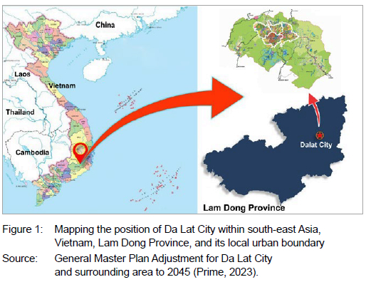
Da Lat City is a highland city located in Lam Dong Province, in Vietnam's Central Highlands region, approximately 1,500 metres above sea level (Management Agency, 2024). Figure 1 shows its position at multiple spatial scales - continental (south-east Asia), national (Vietnam), regional (Lam Dong Province), and local (Da Lat urban core) - to illustrate the city's geographical context and connectivity.
The city covers a core urban area of roughly 5,900 hectares, with a broader peri-urban region extending into surrounding valleys and mountainous terrain. According to the most recent official statistics (Management Agency, 2024), Da Lat City has a population of approximately 260,000 permanent residents, with seasonal population fluctuations driven by tourism. The city was originally established as a French colonial resort town in the late 19th and early 20th centuries, chosen for its mild climate, abundant pine forests, and scenic lakes. Its physical terrain is characterised by steep hills, winding roads, and a complex topography that significantly influence the spatial configuration of its street network and urban accessibility (Table 1). Da Lat City's topography is highly irregular, shaped by a series of plateaus, steep slopes, and narrow valleys formed by surrounding mountain ranges. Elevation differences between neighbourhoods often exceed 100-200 metres, creating significant gradients that affect road design and connectivity (Figure 2). Many streets follow natural contours, resulting in winding and sometimes discontinuous routes, particularly in peripheral areas where terrain constraints limit direct road construction.
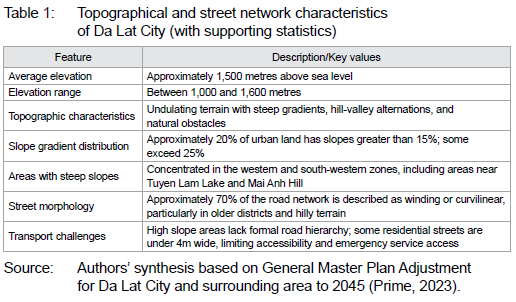
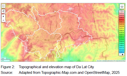
These physical conditions pose challenges for developing efficient transport infrastructure, increasing travel distances and complicating efforts to improve walkability and public transit accessibility. The city's elevation and undulating landscape create challenges for transport infrastructure, particularly for walkability and direct connections between neighbourhoods.
Da Lat City's economy is dominated by high-value tourism and specialised agriculture, particularly greenhouse-based vegetable and flower production, which supply major urban centres across Vietnam. The city functions as both a major tourist destination - receiving over 6 million visitors annually - and a regional hub for education, healthcare, and administrative services. These socioeconomic dynamics have accelerated urbanisation, increasing pressure on the existing road network, contributing to traffic congestion, and leading to rapid land-use changes at the expense of open green spaces and natural habitats.
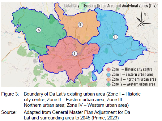
The General Master Plan to 2030, with a vision to 2050, provides the strategic framework for managing Da Lat City's rapid urbanisation through a polycentric development model supported by six satellite towns. It aims to protect ecological resources while improving connectivity through strategic transport corridors, notably the planned East-West Heritage Axis and the North-South Landscape Axis. This planning context provides the foundation for assessing whether current spatial configurations can support the city's long-term sustainability goals. This study focuses on the existing urban area of Da Lat City, structured into four primary zones for analytical purposes:
• Zone I: The historic city centre encompasses the traditional urban core surrounding Xuan Huong Lake and serves as the focal point for the city's commercial and administrative functions.
• Zone II: The eastern urban area is a rapidly developing district characterised by residential expansion, tourism-related services, and ongoing conversion of agricultural land.
• Zone III: This zone, located in the northern part of the city, is predominantly residential, with relatively low road density and limited accessibility.
• Zone IV: The western urban area represents a peripheral zone marked by hilly terrain, sparse development, and fragmented road infrastructure (see Figure 3).
4. METHODOLOGY
4.1 Research design
To conduct a comprehensive spatial analysis, road network data for Dalat was collected to provide detailed insights into the street system and intersection structure. This dataset includes geographic coordinates, network connectivity, and specific road characteristics, forming a robust foundation for spatial analysis. The primary data source was extracted from OpenStreetMap (OSM) using the Python programming language and the Osmnx package, an advanced toolkit developed by Jeff Boeing (Boeing, 2017) for acquiring and analysing geospatial network data. The collected spatial data was analysed, using DepthmapX, an open-source spatial network analysis software developed by the UCL Space Syntax Group (Turner, 2004). Based on Space Syntax theory, the software computes various spatial configuration metrics such as integration, connectivity, choice, and depth to quantify how streets and spaces are interlinked. The resulting values are visualised as colour-coded maps, where warmer colours (e.g., red, yellow) represent higher values, and cooler colours (e.g., blue) represent lower values.
In addition, data related to urban spatial development, land-use distribution, and transportation networks were compiled from the approved General Master Plan for Da Lat City to 2030, with a vision to 2050 (Prime, 2014). This comprehensive dataset serves as the basis for evaluating Dalat's spatial structure, connectivity, and accessibility, providing critical insights into how the city's urban form aligns with long-term development objectives.
4.2 Data analysis
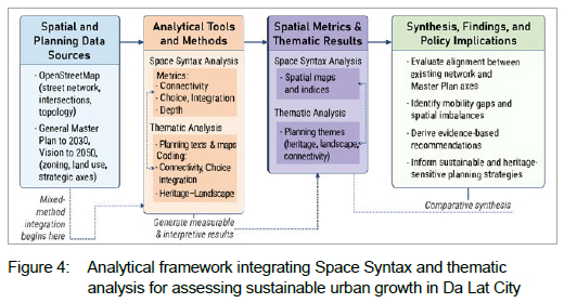
To ensure clarity and replicability, this study develops an analytical framework that integrates both quantitative and qualitative methods (Figure 4). The framework illustrates the interconnections between data sources, analytical tools, and expected outcomes. Spatial network analysis (based on Space Syntax theory) provides quantitative indicators such as connectivity, choice, integration, and depth to evaluate Da Lat City's existing street network. Thematic analysis, on the other hand, interprets the planning intentions expressed in the General Master Plan to 2030, with a vision to 2050. Together, these components create an evidence-based approach for assessing how spatial configuration supports or constrains the city's sustainable urban growth and heritage-sensitive planning.
4.2.1 Space Syntax as an analytical method
Space Syntax is a 'theory of spatial configuration' that explains how the arrangement and connectivity of urban spaces influence patterns of movement, accessibility, and social interaction (Hillier et al., 1993). Based on this theoretical foundation, a set of computational methods was developed to measure and visualise (model) these spatial relationships quantitatively (Turner, 2007; Al Sayed et al., 2014; Van Nes, 2014). Operationally, the Space Syntax method transforms a city's street system into a graph-based model, where spaces such as street segments or axial lines are represented as nodes and their connections as edges. This model enables the calculation of topological relationships, namely how many spaces can be reached from each node; how often a node lies on the shortest paths between others, and how deep or shallow it is within the system. These measures yield quantitative indicators of accessibility, connectivity, and centrality, allowing spatial structures to be objectively compared and visualised.
Unlike most of the planning assessments in Vietnam, which rely on descriptive mapping or qualitative judgment, Space Syntax provides an evidence-based means of evaluating whether Da Lat City's existing street network supports the objectives of its General Master Plan to 2030, with a vision to 2050, by revealing how the city's morphology affects accessibility, circulation, and spatial hierarchy. This addresses a critical research gap - the lack of empirical spatial analysis linking statutory planning frameworks with the real structural properties of urban networks in heritage and highland contexts.
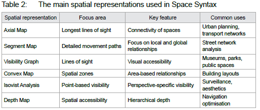
Several spatial representation methods are used within Space Syntax to model different dimensions of spatial configuration (Table 2). These include Axial Maps, Segment Maps, Visibility Graphs, Convex Maps, Isovist Analyses, and Depth Maps. Among these, the Axial Map was selected for this study because it most effectively captures Da Lat's linear street network for evaluating movement and connectivity.
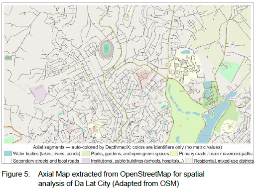
In this study, the axial representation reduces Da Lat City's complex street system into a simplified network of the longest lines of sight and movement paths. Figure 5 illustrates the axial map extracted from OpenStreetMap and processed in DepthmapX, showing each axial line as a distinct segment in the network for Da Lat City's urban area. The colours used in Figure 5 differentiate the axial segments automatically assigned by the software to represent individual lines, and do not indicate any calculated values.
Four principal syntactic measures were employed to quantify Da Lat City's spatial configuration, namely connectivity, choice, integration, and depth.
• Connectivity Index measures the number of direct connections a space (or node) has with other spaces. This metric is essential for assessing local accessibility within an urban system. It highlights areas where streets are most interlinked - crucial for identifying well-connected urban cores in Da Lat City's hilly terrain. Connectivity is calculated as follows:
Where:
k(i) = Connectivity of space i
N(i) = The set of spaces that are directly connected to space
The higher the connectivity value, the more accessible and well-integrated a space is within the urban network.
• Choice Index (Betweenness Centrality) measures how frequently a particular street segment appears along the shortest paths between other locations. This metric is crucial in identifying high-traffic streets that may require infrastructure enhancements to accommodate increased mobility demands. Conversely, streets with low Choice Index values may indicate underutilised areas, suggesting potential opportunities for redevelopment or reconfiguration to attract more urban activities. It helps to identify corridors such as Tran Phu and Hung Vuong Streets that carry high city-wide mobility flows. The Choice Index is calculated as:
Where:
is total number of shortest paths between space s and t, is number of shortest paths between space s and t that pass-through space i.
• Integration Index evaluates the accessibility and centrality of a space within the urban network. A high integration value signifies a well-connected space that plays a central role in urban interactions, whereas a low integration value indicates a peripheral or isolated space. Highly integrated streets tend to correspond with vibrant commercial or mixed-use areas - key for evaluating how Da Lat City's central core supports compact and accessible urban growth. The Integration Index is calculated using:
Where:
is a constant depending on the number of nodes, typically calculated based on the theoretical depth distribution of an idealized system.
is total number of nodes in the system, is the mean depth of a node i.
• Depth Index measures how deep or shallow a space is relative to the entire urban system. It is used to assess the ease of accessibility from a reference point, helping to identify hierarchical relationships within urban layouts. Areas with high depth values reveal peripheral or topographically isolated zones, highlighting where urban expansion faces connectivity challenges. The Depth Index is computed as follows:
Where:
is depth of node I,
is the set of all paths from the root space r to space I,
is topological step distance of space j along the path.
Applying these metrics enables an evidence-based assessment of how Da Lat's urban morphology supports or limits accessibility and movement. By combining the theoretical premise that spatial configuration shapes social and economic processes with the computational method that quantifies this relationship, the Space Syntax framework bridges descriptive planning and quantitative spatial evaluation.
4.2.2 Thematic analysis
The thematic analysis method was employed to interpret the spatial development strategies outlined in the General Master Plan for Da Lat City and its surrounding areas to 2030, with a vision to 2050. The objective of this analysis was to identify how the plan addresses spatial connectivity, accessibility, and integration of heritage and landscape values, and to compare these planning intentions with the results of the Space Syntax analysis.
Thematic analysis is a widely used qualitative method in planning and policy research, designed to identify, organise, and interpret recurring patterns or themes in textual and visual data (Braun & Clarke, 2006; Nowell et al., 2017). In this study, the method was structured in four sequential steps.
• Document collection: Official planning decisions, land-use allocation maps, and transport network proposals were collected and examined.
• Coding: Textual and visual contents were coded, based on four key spatial elements, namely connectivity, choice, integration, and heritage-landscape axes, derived from Space Syntax theory and urban planning literature (Hillier et al., 1993; Turner, 2007; Porta et al., 2006b).
• Theme development: Codes were grouped to identify broader patterns or strategies in the Master Plan, including planned improvements in accessibility, major movement corridors, and strategies for integrating heritage and landscape values within a polycentric development framework. Three primary themes were developed: Spatial connectivity and accessibility -How the plan promotes linked and navigable urban networks; integration of heritage and landscape corridors within the urban network, and implications for sustainable and heritage-sensitive growth.
• Interpretation: The thematic findings were then compared with the Space Syntax results to assess consistencies, gaps, and potential mismatches between planning intentions and existing spatial structures. This cross-validation highlighted where proposed policies supported or contradicted the city's actual connectivity and integration patterns.
Such a structured approach made the evaluation of the Master Plan transparent, replicable, and grounded in theory, while avoiding subjective interpretation and linking policy analysis with data-driven spatial findings.
5. RESULTS
5.1 Connectivity analysis
The connectivity analysis of Da Lat's street network was performed, using DepthmapX to evaluate the number of direct connections each street segment has with its adjacent segments. This metric reflects accessibility, where higher values indicate streets that are well-linked to surrounding roads, while lower values suggest spatial isolation or dead-end streets. The analysis of Da Lat's street network, conducted through Angular Connectivity Analysis, provides valuable insights into the structural and functional accessibility of the city's urban spaces. Figure 6 visualises the global-scale connectivity results, using a colour gradient, where warmer colours (yellow to red) indicate higher connectivity and cooler colours (blue) indicate lower connectivity. The numerical values shown on the map range from 0 to 6.02, representing the count of immediate connections a street segment has within the analysed network. This method assesses the degree to which each street segment is connected to adjacent roads, offering a clear representation of key movement patterns and potential mobility challenges. The colour-coded visualisation effectively illustrates variations in connectivity, where highly connected streets appear in yellow and green, and less integrated streets are represented in blue.
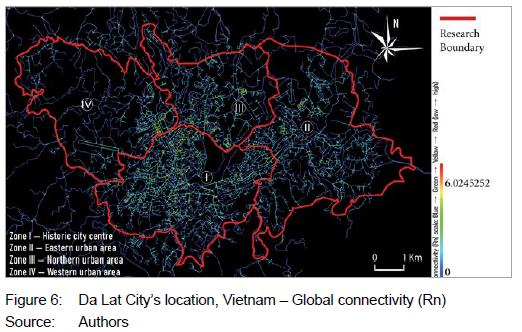
According to Figure 6, the highest connectivity value recorded in Da Lat City's street network is 6.02, corresponding to segments within the central urban core (notably along Hoang Van Thu, Tran Phu, and Tran Hung Dao streets), which are directly connected to up to six other segments. In contrast, peripheral or terrain-constrained areas exhibit connectivity values close to 0.001.50, reflecting limited links or single-access roads often found in steep hillside neighbourhoods. In light of the research objectives, this indicates that Da Lat City's spatial structure remains strongly centralised, with high accessibility concentrated in the historic core and weak local connectivity in outer zones. Such imbalance challenges the Master Plan's vision of polycentric and equitable growth, suggesting that improving lateral linkages and slope-adapted road designs in peripheral areas will be crucial for achieving sustainable and inclusive urban development.
At the heart of Da Lat City, the central urban core exhibits a dense network of highly connected streets, reinforcing its role as the city's primary commercial and transportation hub. These high-connectivity zones, marked by yellow and green segments, facilitate seamless pedestrian movement, efficient public transportation, and vibrant economic activity. Streets within this zone likely include main thoroughfares, commercial corridors, and key public spaces that serve as vital connectors within the larger street network. The strong interconnectivity in this area enhances urban vibrancy and walkability, reducing travel distances and supporting a dynamic, pedestrian-friendly environment.
As one moves outward from the city centre, connectivity gradually diminishes, as indicated by the prevalence of blue segments in peripheral regions. These less integrated areas often consist of local roads, dead-end streets, and terrain-constrained routes, which may include rural or mountainous areas. The fragmented road network in these zones contributes to transportation inefficiencies, restricted accessibility, and greater reliance on private vehicles or limited public transit options. Given these spatial patterns, urban planners may need to consider strategic road expansions and infrastructure improvements in these lower connectivity areas to enhance mobility and promote equitable access to essential city services.
From a broader urban planning perspective, the connectivity analysis underscores the need for a holistic approach that integrates transportation planning with land-use development. Well-connected central areas - particularly Zone I, the historic city centre surrounding Xuan Huong Lake - should be reinforced with efficient public transportation systems, pedestrian-friendly infrastructure, and mixed-use developments, ensuring that movement remains seamless and sustainable. In contrast, peripheral areas such as Zone II (eastern expansion areas), Zone III (northern residential districts), and Zone IV (western hillside neighbourhoods around Tuyen Lam Lake) exhibit lower connectivity and may require targeted infrastructure investments, including the development of new road links, slope-adapted street designs, improved public transit access, and enhanced walkability measures, supporting stronger integration between these outer zones and the urban core.
The analysis also reveals potential traffic bottlenecks, as certain highly connected roads serve as primary arteries, accommodating a significant share of urban mobility. While these thoroughfares are essential for citywide movement, they are also susceptible to congestion, increased vehicular load, and reduced efficiency during peak hours. Identifying these critical routes enables proactive planning through traffic-management strategies, road-widening projects, and alternative transportation solutions, ensuring that urban mobility remains efficient and adaptable as Da Lat continues to grow.
These results indicate that Da Lat's city centre functions as the primary local hub of movement, with multiple interlinked streets enhancing walkability and circulation, whereas outlying areas remain poorly connected. This disparity highlights potential mobility challenges for residents in the periphery and suggests that targeted improvements to local street connections could reduce spatial segregation and improve overall network accessibility. The most highly connected segments are located along Hoang Van Thu, Tran Phu, Tran Hung Dao, and Hung Vuong Streets, which form the city's primary east-west movement corridor. These streets function as both the physical and symbolic backbone of Da Lat City, linking the historic core around Xuan Huong Lake with emerging urban districts.
Their strong local connectivity not only underpins Da Lat's spatial identity but also anticipates the high movement potential confirmed in the subsequent Choice analysis.
5.2 Choice analysis
In Spatial Choice Analysis, DepthmapX calculates how often a street segment is used as part of the shortest path between all other pairs of segments. The analysis identifies the most frequently traversed paths within an urban network, measuring the probability of a street segment being included in the shortest paths between all origin-destination pairs. The visualisation employs a colour-coded scheme to distinguish movement potential, where red and yellow signify the most strategic routes, while blue and darker shades represent less frequently used paths (see Figure 4). Figure 7 visualises the results of the global-scale Choice analysis. The numerical values range from 0 to 527,311,460, representing the cumulative number of shortest-path routes that pass through each segment. A higher Choice value indicates that a street acts as a major connector or "busy" route, frequently used to link different parts of the city. Conversely, lower Choice values signify minor or local streets with limited strategic importance in the overall network. Based on the results and Figure 7, the highest Choice value (527,311,460; highlighted in red) corresponds to major east-west corridors such as Hoang Van Thu, Tran Phu, Tran Hung Dao, and Hung Vuong streets, which function as key urban spines for long-distance movement. The analysis reveals that the most critical streets for city-wide movement are concentrated along a primary east-west axis, with key extensions branching outward in various directions. This pattern suggests that Da Lat City's urban network is highly dependent on a limited number of main corridors for both vehicular and pedestrian circulation. The red-highlighted roads are well-positioned to facilitate commercial activities, public transportation, and access to major urban hubs, reinforcing their role in city-wide accessibility and economic vitality. Meanwhile, yellow and green segments, which are slightly less central but still well-integrated, play a supporting role in distributing movement across different neighbourhoods, ensuring a balanced urban flow beyond the primary corridors. Conversely, peripheral streets such as local roads, deadends, or minor connectors exhibit values close to zero (highlighted in blue), indicating their minimal role in city-wide connectivity and their primary function in serving local circulation. Their low centrality values suggest that they do not significantly impact overall network efficiency, with movement largely restricted to local traffic. This analysis underscores the importance of maintaining and optimizing the highly connected corridors, while also considering strategic improvements to lower centrality areas to enhance network resilience and accessibility across the city.
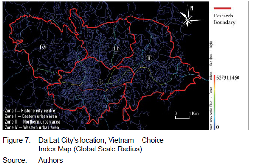
These findings confirm that Da Lat City's street network is highly dependent on a limited set of central corridors, concentrating most movement flows along a few key routes. This reliance creates a potential vulnerability to congestion, suggesting that future planning should consider -axis (Hoang Van Thu, Tran Phu, Tran Hung Dao, Hung Vuong), where tourist traffic, local commuting, and service delivery all overlap. This single-axis dependency undermines the Master Plan's intended polycentric structure and risks reducing accessibility for peripheral districts such as the northern (Zone III) and western (Zone IV) areas. Without new cross-connections or parallel corridors, movement efficiency and resilience will remain constrained, contradicting the city's sustainable and heritage-sensitive growth objectives.
5.3 Integration analysis
The Spatial Integration Analysis (Rn) of Da Lat City's urban street network evaluates the degree to which each street segment is integrated into the overall city network, highlighting accessibility and connectivity across different urban spaces. Figure 8 illustrates the results of the global-scale Integration analysis for Da Lat City's street network. The numerical values range from 0 to 2,850.11, indicating the relative accessibility index of each street segment, as calculated by DepthmapX. The colour-coded visualisation distinguishes levels of integration, with red and yellow segments highlighting highly integrated streets, whereas green and blue segments denote those with lower levels of integration. A higher value signifies that the segment is well-connected and centrally positioned within the city's network, making it more likely to attract pedestrian and vehicular movement. Conversely, a lower value suggests that the segment is spatially deep, requiring more topological steps to reach from other areas, thus being less accessible and less likely to experience high traffic flows.
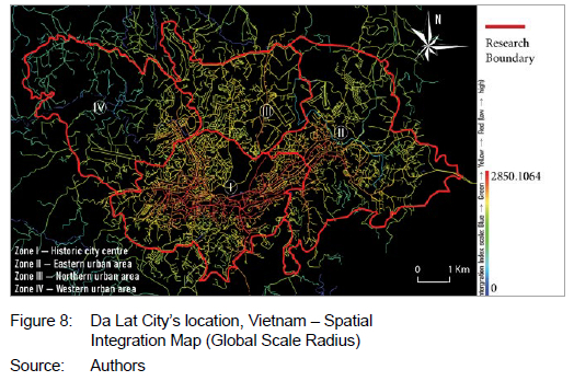
According to Figure 8, the highest Integration value (2,850.11) is concentrated along Da Lat City's primary east-west corridor, comprising Hoang Van Thu, Tran Phu, Tran Hung Dao, and Hung Vu'o'ng streets. This well-connected urban spine serves as the city's principal axis for movement and commercial activity, functioning as a backbone for transportation, economic exchange, and public life. Streets highlighted in red represent the most accessible segments, suggesting high levels of pedestrian and vehicular flow. Their strong integration values indicate a pivotal role in structuring mobility patterns and facilitating tourism and economic vitality across the city.
In contrast, as the urban fabric extends outward from the city centre, peripheral roads and terrain-constrained residential areas exhibit significantly lower integration values - often below 500 - that gradually decrease, as indicated by a transition from yellow and green to blue-coloured streets. These peripheral roads exhibit lower connectivity, reflecting reduced accessibility and weaker integration within the broader network. Such areas are typically found in suburban, rural, or topographically constrained zones, where road networks are more fragmented, resulting in longer travel distances and limited interaction with the city's core. The low-integration streets primarily serve local traffic rather than facilitating city-wide movement, making them less favourable for commercial and high-density development but more suitable for residential purposes. This analysis underscores the importance of strengthening key urban corridors to maintain efficient mobility, while also identifying opportunities for targeted infrastructure improvements in low-integration areas to enhance urban accessibility and network resilience.
These results highlight a spatial imbalance in Da Lat City's network, where a few key corridors dominate urban accessibility, while peripheral areas remain poorly integrated. This finding underscores the need for future planning interventions to strengthen links between low-integration zones and the city core, enhancing spatial cohesion and overall urban mobility. Such improvement can be enabled through a combination of strategies, including the development of secondary connector roads linking peripheral districts (Zones II-IV) to the main east-west corridor, the integration of slope-adapted public transport routes to overcome topographic barriers, and the creation of pedestrian-friendly linkages around Xuan Huong Lake and the Heritage Axis. Together, these measures would diversify movement options and distribute traffic more evenly across the urban network.
5.4 Spatial Depth analysis
Depth analysis evaluates how deep or shallow a street segment is within the overall urban network, providing insights into how easily accessible different areas are from a global perspective. Streets with low depth values (shallow spaces) are highly integrated and more accessible, whereas those with high depth values (deep spaces) are more segregated and harder to reach.
Figure 9 presents the results of the Depth analysis, where numerical values range from 0 to 4,678,830. A lower depth value (close to 0) indicates that a street segment can be reached from most of the other segments through fewer steps, reflecting higher accessibility. In contrast, higher values signify that a segment requires many steps to access other parts of the network, representing low accessibility or high spatial segregation. The colour scheme in Figure 8 illustrates spatial depth across Da Lat City's street network. Blue segments indicate low depth values (0-00,000), corresponding to highly accessible streets situated near the urban core. In contrast, green segments represent high depth values (above 3,000,000), highlighting spatially segregated streets typically found in peripheral or terrain-constrained areas with limited direct connectivity.
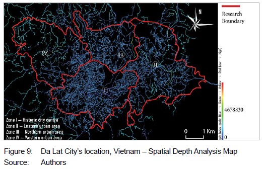
According to Figure 9, the maximum depth value (4,678,830) occurs in outlying hillside roads on the city's western periphery, where the network is fragmented and indirect. The central districts demonstrate very low depth values (<100,000), confirming their strong spatial integration and accessibility. This analysis highlights a pronounced contrast between the central urban core and peripheral zones, where fragmented road structures create extended travel distances. Addressing this disparity will require strategic interventions such as creating new road links or improving pedestrian connections, in order to reduce topological distance and enhance overall urban accessibility.
5.5 Analysis of key elements in the adjusted master plan to 2045 for existing urban area of Da Lat City
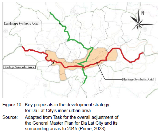
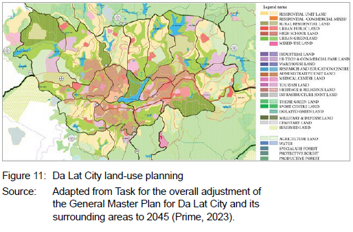
Building upon the planning framework discussed in section 2.2, the thematic analysis of Da Lat City's General Master Plan to 2030, with a vision to 2050, was structured around three key spatial elements identified in the Research Methods section, namely connectivity, choice, and integration. This approach ensures consistency with the Space Syntax framework and allows a direct comparison between current spatial conditions and planned development strategies. One of the most significant proposals in Da Lat City's General Master Plan adjustment is the establishment of the Heritage Axis, the Landscape Axis, and the diversification of urban areas supporting the Heritage Axis (see Figures 10 and 11). These strategies play a pivotal role in preserving the city's historical identity, while maintaining its distinctive natural landscape (see Figure 10).
5.5.1 Connectivity
The General Master Plan places strong emphasis on improving connectivity at both the intra-urban and regional scales. Several interventions are proposed, including the addition of new road links to bridge fragmented areas, the creation of multiple intersections to enhance cross-district movement, and the development of ring roads and radial corridors to connect Da Lat City's historic core with its six satellite towns. These strategies are intended to ease pressure on the central districts, by providing alternative routes and redistributing traffic flows across the wider urban area. Findings from the Space Syntax connectivity analysis (section 5.1) highlight both opportunities and limitations in this approach. The historic core of Da Lat City already demonstrates high connectivity values (up to 6.02), indicating that the existing network supports dense interaction and strong accessibility. This aligns well with the Master Plan's goal of reinforcing the central area as a commercial, cultural, and administrative hub. In contrast, the peripheral and topographically constrained zones record very low values (0.00-1.50), reflecting fragmented road networks and limited access routes. These conditions raise concerns that the Master Plan's large-scale corridors, if not supported by finer grained improvements, may fail to adequately integrate suburban and hillside communities.
Connectivity in Da Lat City is also influenced by the city's steep terrain and organically developed road structure. Unlike planned grid systems, Da Lat City's road network follows natural contours, resulting in winding and discontinuous routes. While the Master Plan proposes new arterial connections, without attention to smaller local streets such as secondary connectors, pedestrian paths, and slope-sensitive road designs, large-scale interventions may reinforce rather than reduce existing inequalities. Enhancing localised connections within residential neighbourhoods and tourism areas will, therefore, be crucial to ensuring that the benefits of improved connectivity are widely distributed. Moreover, the analysis indicates the presence of potential bottlenecks, where highly connected roads act as primary urban arteries. These include the central east-west corridors that already accommodate a disproportionate share of citywide movement. The Master Plan partially addresses this, by proposing ring-road linkages, but complementary strategies such as multi-modal transport integration, improved public transit access, and traffic management systems are equally necessary. By combining macro-scale infrastructure with micro-scale connectivity enhancements, Da Lat City can move toward a more resilien and equitable transport network that supports both residents and visitors.
5.5.2 Choice
In the General Master Plan, the concept of movement choice -defined in Space Syntax theory as the probability that a street segment lies on the shortest paths between all other pairs of segments, indicating its importance as a through-movement route - is implicitly addressed through the reinforcement of primary east-west corridors and the designation of multifunctional boulevards. Streets such as Hoang Van Thu, Tran Phu, Tran Hung Dao, and Hung Vuong are planned to serve simultaneously as transport spines, commercial boulevards, and cultural corridors. This strategy aims to concentrate flows along well-established routes, supporting tourism accessibility, while sustaining the economic vibrancy of the city centre. The Space Syntax Choice analysis (section 5.2) confirms the strategic role of these streets, which exhibit the highest choice values in the network (up to 527,311,460). This indicates that they naturally function as the most frequently traversed segments within the urban system, funnelling both vehicular and pedestrian flows through the city. The Master Plan's proposal to enhance these corridors with integrated land-use and public transport services is, therefore, consistent with empirical findings, ensuring that existing high-movement routes are reinforced rather than bypassed.
However, concentrating urban flows along a single dominant axis presents risks. First, over-reliance on the east-west corridor may lead to chronic congestion, particularly during peak tourist seasons when Da Lat City's population swells significantly. Secondly, this concentration may generate spatial imbalances, where economic activity and mobility are disproportionately channelled through central areas, leaving peripheral districts relatively disconnected from the main urban flow. Such patterns risk exacerbating urban inequality by consolidating opportunities along one corridor, while neglecting other zones. The Master Plan makes initial attempts to mitigate these risks, by proposing ring roads and radial connectors,
but the analysis suggests that more deliberate diversification of high-choice routes is required. Developing parallel or complementary corridors - for example, enhancing north-south connections that link residential districts to the Heritage and Landscape Axes - would help distribute flows more evenly and reduce pressure on a single axis. In addition, promoting multi-modal integration along medium-choice streets such as public bus routes, pedestrian-friendly paths, and cycling lanes could increase route variety and flexibility for users, improving overall network resilience.
Ultimately, aligning Master Plan strategies with Choice analysis highlights a critical planning priority. While reinforcing existing high-choice streets is necessary, ensuring redundancy and flexibility in the movement network is equally important for Da Lat City's sustainable growth. A diversified set of high-choice corridors would enhance accessibility, support balanced economic activity, and safeguard against congestion vulnerabilities, making the city more adaptable to rapid urbanisation and tourism dynamics.
5.5.3 Integration
The General Master Plan highlights integration through two major structural proposals, namely the East-West Heritage AAxis and the North-South Landscape Axis. These corridors are intended to connect cultural, ecological, and recreational spaces, thereby linking heritage assets and green networks into the broader urban fabric. By doing so, the plan seeks not only to preserve Da Lat City's identity, but also to enhance accessibility to key cultural and ecological resources.
The Space Syntax Integration analysis (section 5.3) shows strong alignment with this vision. Streets along the proposed Heritage Axis overlap with segments that already demonstrate high integration values, confirming their potential as vibrant cultural and tourism corridors. This empirical support suggests that the plan's emphasis on heritage-led development is well grounded in the existing spatial structure. At the same time, the analysis also reveals persistent gaps. Peripheral neighbourhoods remain characterised by very low integration values, limiting their accessibility to both the city centre and the proposed axes. Without complementary interventions such as feeder roads, improved transit services, or secondary connectors, these areas risk becoming further marginalised as development concentrates around integrated central corridors. In short, the Master Plan's proposals for integration align with the strongest parts of Da Lat City's network, but their success will depend on extending accessibility benefits to peripheral zones. Ensuring that the Heritage and Landscape Axes are not exclusive corridors but rather inclusive backbones that connect diverse urban areas will be crucial for promoting balanced and equitable urban development.
Taken together, the thematic analysis reveals both alignment and divergence between the Master Plan and the spatial network analysis. On the one hand, key proposals such as reinforcing high-choice corridors and establishing heritage-oriented integration axes are well supported by spatial metrics, indicating a strong foundation for strategic movement and cultural connectivity. On the other hand, persistent gaps remain in addressing weak local connectivity in peripheral areas and reducing the city's reliance on a limited number of high-centrality routes. Bridging these gaps will require a more deliberate alignment between planning interventions and evidence derived from spatial analysis. Such an approach will be essential to realising a more balanced, inclusive, and resilient urban structure for Da Lat City by 2050.
6. DISCUSSION
6.1 Urban connectivity and spatial development orientation of Da Lat City
The analysis of Da Lat City's urban traffic network reveals a moderate level of connectivity within the existing urban area, with notable disparities between the four predefined urban zones (see Figure 3 and section 3). This reflects the limited capacity of the current network structure, which ensures a relatively balanced level of connectivity between different zones. The historic city centre (Zone I) demonstrates the strongest connectivity values (up to 6.02), reflecting its dense grid of interlinked streets and its role as the main hub for commercial and administrative activities. In contrast, the eastern (Zone II) and northern (Zone III) areas exhibit more fragmented networks, where residential expansion and limited road density constrain local accessibility, while the western area (Zone IV) remains the most isolated zone, due to steep topography and sparse development, producing low connectivity values (close to 0-1.50, as reported in Figure 6). These findings suggest that urban expansion may place additional strain on the existing transport system, leading to significant challenges in urban connectivity management. This aligns with the perspectives of urban planning experts, who have emphasised the necessity of establishing key urban zones, including core areas, buffer zones, and satellite cities, alongside the development of regulatory frameworks for urban management, particularly in the preservation of the historical core and architectural heritage (Nguyin, 2018). To ensure balanced spatial development, future planning interventions should prioritise the strengthening of linkages between Zones II to IV and the historic city centre, the creation of additional cross-connections to reduce reliance on a limited number of high-connectivity corridors, and the enhancement of walkability and accessibility in newly developed residential and tourism areas. Aligning these improvements with the strategic directions set out in the 2030 General Master Plan will be essential to fostering a more cohesive, resilient, and well-connected urban network across Da Lat City's existing urban area.
Spatial Depth analysis indicates that many areas within Da Lat City's urban network are highly segmented, requiring multiple turns or steps to reach key destinations. While the overall connectivity of the traffic network is fairly strong, the winding street layout and organically developed road system reduce direct accessibility. These factors result in longer travel distances compared to more linear, grid-like networks, limiting mobility efficiency for both residents and visitors. Without targeted interventions, continued urban expansion could exacerbate these accessibility challenges, leading to increased travel times and reduced overall effectiveness of the transport system.
Given that Da Lat City is a tourism-oriented city, its urban connectivity must not only serve residents, but also facilitate seamless mobility for visitors, enhancing their urban experience. Strengthening pedestrian accessibility and public spaces is among the key strategies to improve urban liveability and tourism appeal. Previous studies have highlighted the importance of the 15-minute city model, where residents can access essential services within a 15-minute walk, as a crucial element of sustainable urban design (Mehaffy et al., 2015). Current data suggests that, if the existing urban footprint is well-regulated, achieving shorter travel distances and maintaining strong connectivity between key areas will be a realistic and sustainable goal for Da Lat City's future development.
6.2 Balancing the contrasting aspects of the Heritage Axis and the Landscape Axis
This study demonstrates the high validity of integrating the Heritage Axis and its core area into Da Lat City's urban master plan for 2030 and its vision for 2045 (Prime, 2023). The Spatial Choice analysis of the city's urban structure confirms that the Heritage Axis holds the highest choice index, meaning that it will be the most accessible corridor within the urban network. This suggests that both residents and tourists will naturally engage with the city's historical and cultural landmarks, even without explicit wayflnding interventions. This characteristic plays a crucial role in enhancing the urban experience and maximizing the potential of Da Lat City's heritage through organic connectivity.
Moreover, Spatial Integration analysis confirms that the urban areas planned around the Heritage Axis exhibit high levels of integration, making them ideal for pedestrian movement and urban services. This has significant implications for commercial development, tourism, and overall urban vibrancy, as high integration typically correlates with strong accessibility and increased urban interactions. The Heritage Axis not only structures economic and social activities, but it also serves as a fundamental backbone within Da Lat City's urban framework. These findings also explain the high traffic volume observed along this corridor, as noted in recent urban planning reports (Prime, 2024).
However, the high degree of integration also poses potential traffic congestion risks, as the Heritage Axis doubles as a primary transportation route for both motorised and non-motorised traffic. The convergence of urban mobility and tourism-related activities could lead to conflicts between local transportation needs and heritage site experiences. In particular, sightseeing and cultural exploration could be disrupted without appropriate traffic management strategies in place. To mitigate these challenges, adopting a mixed-use and diversified land-use model along the Heritage Axis could be an effective solution. This approach would capitalise on the urban structure's strengths, while alleviating pressure at key intersections, improving both heritage conservation efforts and overall traffic efficiency (Prime, 2024). In addition, extending the heritage core at both ends of the axis could help distribute urban movement more evenly, reducing the excessive concentration of activities in specific hotspots.
Parallel to the Heritage Axis, the Landscape Axis is also strategically planned to enhance Da Lat City's natural environment, while improving connectivity across different urban zones. However, spatial analysis indicates that this green corridor also attracts significant movement flows, involving both local residents and tourists. This raises concerns about potential conflicts between sightseeing activities and urban traffic circulation. Addressing these issues requires carefully designed planning strategies to ensure that heritage preservation, scenic experiences, and transportation efficiency are balanced (Tran, 2024). One effective approach could be the implementation of greenways or ecological corridors, which have been successfully applied in urban settings to facilitate movement, while maintaining environmental and visual integrity (Do et al., 2018). These green corridors would not only enhance ecological connectivity, but also preserve Da Lat City's iconic landscape character, ensuring that sustainable urban mobility aligns with the city's unique identity as a highland heritage destination.
7. RECOMMENDATIONS
Based on the spatial and thematic analyses, this study proposes a set of strategic and spatially targeted recommendations to guide Da Lat City's sustainable and heritage-sensitive urban development in alignment with the General Master Plan to 2030, with a vision to 2050.
7.1 Strategic directions
To address Da Lat City's spatial and mobility challenges, while preserving its cultural and ecological identity, five strategic directions are proposed as follows.
• Strengthen polycentric connectivity, by developing secondary road linkages and cross-connecting routes between peripheral zones (Zones II-IV) to reduce dependence on the east-west core corridor (Hoang Van Thu, Tran Phu, Tran Hung Dao, Hung Vuong), thereby improving resilience and distributing traffic more evenly.
• Integrate slope-adapted public transport through hillside-compatible bus routes or tram systems that connect lower integration neighbourhoods with the central core to overcome topographic constraints
• Reinforce the Heritage and Landscape Axes, by encouraging mixed-use, pedestrian-friendly redevelopment along the East-West Heritage Axis and supporting ecological restoration along the North-South Landscape Axis, preserving Da Lat City's dual identity of cultural richness and environmental value
• Promote walkability and active mobility by upgrading sidewalks, pedestrian crossings, and green pathways, especially around Xuan Huong Lake and the city centre, to encourage sustainable local travel and enhance the tourist experience
• Institutionalise spatial analysis in planning practice, by incorporating tools such as Space Syntax into regular planning processes at both citywide and district levels to ensure transparency, spatial logic, and evidence-based decision-making.
7.2 Spatially targeted interventions
Applying Space Syntax theory, this study conducts a spatial network analysis of Da Lat City's existing urban area, evaluating proposed planning strategies for the inner city core and broader spatial development direction. The findings suggest that optimising urban connectivity and spatial development in Da Lat City is possible. Rather than expanding the urban periphery, the city should focus on enhancing internal connectivity and improving transportation accessibility, particularly given Da Lat City's role as a major tourist destination. Sustainable urban mobility solution such as improving public transport, expanding pedestrian-friendly spaces, and strengthening connections between strategic urban axes are essential for enhancing the transportation network and ensuring the city's long-term sustainable development.
Another finding suggests that the Heritage and Landscape Axes should be optimised. To effectively implement the East-West Heritage Axis and the North-South Landscape Axis, flexible adjustments in land-use planning, traffic organisation, and urban design are required. The integration of natural connectivity principles, minimising conflicts between mobility flows and ensuring landscape sustainability are key strategies in developing Da Lat City as a city that preserves its heritage, while ensuring urban and tourism efficiency.
• Enhancing connectivity along the East-West Heritage Axis: The heritage corridor running through Hoang Van Thu, Tran Phu, Tran Hung Dao, and Hung Vuong streets demonstrates the highest levels of connectivity and choice, confirming its role as the primary movement spine. Strategic improvements such as dedicated pedestrian pathways, signal optimisation, and enhanced public transit services can further strengthen accessibility and support the corridor's dual function as a transport and cultural axis.
• Improving accessibility in peripheral areas: Zones II-IV display lower connectivity and integration values, highlighting fragmented street networks and isolated residential clusters. Introducing additional road links, improving slope management for hillside routes, and establishing cross-connections to Zone I can reduce travel distances and foster more equitable access to services across the city.
• Promoting a sustainable public transit system: Da Lat City's growing urban population and high tourist influx increase reliance on motorised travel. While the study primarily focused on spatial structure, existing municipal reports indicate that private vehicles account for over 75% of daily trips, whereas public transport options remain limited (Prime, 2023). Strengthening public transit such as electric minibuses, shuttle services, and integrated transport hubs can alleviate pressure on main corridors and reduce congestion.
• Strengthening walkability and pedestrian networks: The city's undulating topography, steep gradients, and winding streets, as detailed in the Study Area and supported by travel distance data (Table 1), limit direct pedestrian access between neighbourhoods and key destinations. Expanding safe, accessible footpaths, introducing stepped pathways where terrain is steep, and improving pedestrian crossings can enhance walkability, supporting both residents' daily mobility and visitors' urban experiences.
These strategic directions and interventions aim to transform Da Lat City's spatial network into a more resilient, accessible, and heritage-sensitive urban system. By combining connectivity enhancement, slope-conscious transport design, and walkable public spaces, the city can align its physical development with the long-term vision of sustainable and inclusive growth outlined in the General Master Plan.
8. CONCLUSION
The General Master Plan for Da Lat City and its surrounding areas to 2030, with a vision to 2050, has been approved to establish a strategic urban structure for future growth, leveraging the city's existing framework, while guiding urban expansion and satellite city integration. This plan envisions a well-connected urban system, balancing historical preservation, natural landscape conservation, and modern urban development.
Through the application of Space Syntax-based spatial network analysis, this study has provided new insights into Da Lat City's connectivity challenges and demonstrated the strategic importance of the Heritage and Landscape Axes within the city's long-term planning vision. The findings confirm that Da Lat City's current spatial structure remains highly centralised along a limited east-west corridor, underscoring the need for diversified linkages and slope-adapted mobility solutions to achieve balanced and sustainable urban growth.
Several limitations should be noted. The analysis relies primarily on static spatial data and does not incorporate economic, social, or climate-related variables, nor does it assess the operational quality of transportation infrastructure or public transit systems. Environmental considerations, particularly concerning pine forest ecosystems, water resources, and microclimatic stability, also require further investigation.
Future research should integrate these multidimensional factors to support a more comprehensive and adaptive urban planning strategy. A holistic approach that combines quantitative spatial analytics with environmental and socio-economic dimensions will be essential for ensuring Da Lat City's long-term resilience as a heritage-rich, inclusive, and ecologically sustainable city.
ACKNOWLEDGEMENT
The authors would like to thank M.Arch Tran Thuy Dung from Yersin University of Da Lat, for providing valuable research materials. We also express our gratitude to Ho Chi Minh City University of Technology and Education, for providing partial financial support.
DATA AVAILABILITY STATEMENT
Some or all data, models, or codes that support the findings of this study are available from the corresponding author upon reasonable request.
REFERENCES
AL_SAYED, K., TURNER, A., HILLIER, B., IIDA, S. & PENN, A. 2014. Space Syntax methodology. London: Routledge. [ Links ]
BOEING, G. 2017. OSMnx: New methods for acquiring, constructing, analysing, and visualising complex street networks. Computers, Environment and Urban Systems, 65, pp. 126-139. https://doi.org/10.1016/j.compenvurbsys.2017.06.002 [ Links ]
BRAUN, V. & CLARKE, V. 2006. Using thematic analysis in psychology. Qualitative Research in Psychology, 3(2), pp. 77-101. https://doi.org/10.1191/1478088706qp063oa [ Links ]
DO, D.T., HUANG, J., CHENG, Y. & TRUONG, T.C.T. 2018. Da Nang green space system planning: An ecology landscape approach. Sustainability, 10(10), article 3506. https://doi.org/10.3390/su10103506 [ Links ]
HICKMAN,R. & BANISTER, D. 2016. Sustainable urban mobility. London, UK: Routledge. [ Links ]
This book provides a comprehensive framework for integrating transport and land-use planning to achieve sustainable urban development.
HILLIER, B., PENN, A., HANSON, J., GRAJEWSKI, T. & XU, J. 1993. Natural movement: or, configuration and attraction in urban pedestrian movement. Environment and Planning B: Planning and Design, 20(1), pp. 29-66. https://doi.org/10.1068/b200029 [ Links ]
JABAREEN, Y. 2013. Planning the resilient city: Concepts and strategies for coping with climate change and environmental risk. Cities, 31, pp. 220229. https://doi.org/10.1016/j.cities.2012.05.004 [ Links ]
JENKS, M. & JONES, C. 2009. Dimensions of the sustainabie city. Dordrecht: Springer. https://doi.org/10.1007/978-1-4020-8647-2 [ Links ]
JIANG, B. & CLARAMUNT, C. 2004. Topological analysis of urban street networks. Environment and Planning B: Planning and Design, 31(2), pp. 151-162. https://doi.org/10.1068/b306 [ Links ]
LI, H., ZHOU, Y. & WEI, YD. 2019. Institutions, extreme weather, and urbanization in the Greater Mekong Region. Annais of the American Association of Geographers, 109(6), pp. 1317-1340. https://doi.org/10.1080/24694452.2018.1535884 [ Links ]
LIU, Y, WEI, X., JIAO, L. & WANG, H. 2016. Relationships between street centrality and land use intensity in Wuhan, China. Journal of Urban Planning and Development, 142(3), article 05015001. https://doi.org/10.1061/(ASCE)UP1943-5444.0000319 [ Links ]
MANAGEMENT AGENCY. 2024. Lam Dong Statistical Yearbook 2023. Management Agency: Information Center, Lam Dong Provincial People's Committee Office. [ Links ]
MARSHALL, S. & BANISTER, D. 2007. Land use and transport: European research towards integrated policies. Bingley: Emerald Group Publishing Limited. https://doi.org/10.1108/9780080549910 [ Links ]
MEHAFFY, M.W., PORTA, S. & ROMICE, O. 2015. The 'neighbourhood unit' on trial: A case study on the impacts of urban morphology. Journal of Urbanism: International Research on Placemaking and Urban Sustainability, 8(3), pp. 199-217. https://doi.org/10.1080/17549175.2014.908786 [ Links ]
NGUYEN, TV. 2018. Urban planning and development of Da Lat city. Journal of Construction Planning, 12(3), pp. 45-52. (In Vietnamese). [ Links ]
NOWELL, L.S., NORRIS, J.M., WHITE, D.E. & MOULES, N.J. 2017. Thematic analysis: Striving to meet the trustworthiness criteria. International Journal of Qualitative Methods, 16(1), article 1609406917733847. https://doi.org/10.1177/1609406917733847 [ Links ]
PEPONIS, J. 2024. Architecture and spatial culture. London: Routledge. https://doi.org/10.4324/9781003396673 [ Links ]
PORTA, S., CRUCITTI, P. & LATORA, V. 2006a. The network analysis of urban streets: A dual approach. Physica A: Statistical Mechanics and its Applications, 369(2), pp. 853-866. https://doi.org/10.1016/j.physa.2006.01.090 [ Links ]
PORTA, S., CRUCITTI, P. & LATORA, V. 2006b. The network analysis of urban streets: A primal approach. Environment and Planning B: Planning and Design, 33(5), pp. 705-725. https://doi.org/10.1068/b32045 [ Links ]
PRIME (VIETNAM GOVERNMENT). 2014. Decision 704/QD-TTG about approving the master plan adjustment of Da Lat City and surrounding areas with a vision from 2030 to 2050. vanban.chinhphu.vn [Accessed: 2 February 2024]. [ Links ]
PRIME (VIETNAM GOVERNMENT). 2023. Mandate for the comprehensive adjustment of the general master plan for Da Lat City and its surrounding region to the year 2045 (In Vietnamese). [Accessed: 2 February 2024]. [ Links ]
PRIME (VIETNAM GOVERNMENT). 2024. Comprehensive adjustment of the general master plan for Da Lat City and its surrounding areas to 2045. vbpl.mpi.gov.vn [Accessed: 2 February 2024]. [ Links ]
SEVTSUK, A. & MEKONNEN, M. 2012. Urban network analysis. Revue Internationale de Géomatique-N, 287(1), article 305. https://doi.org/10.3166/rig.22.287-305 [ Links ]
SHI, X., LIU, D. & GAN, J. 2024. A study on the relationship between road network centrality and the spatial Distribution of commercial facilities - A case of Changchun, China. Sustainability, 16(7), article 3920. https://doi.org/10.3390/su16103920 [ Links ]
SONG, C., LIU, Q., SONG, J., YANG, D., JIANG, Z., MA, W., NIU, F. & SONG, J. 2023. The interactive relationship between street centrality and land use intensity - A case study of Jinan, China. International Journal of Environmental Research and Public Health, 20(18), article 5127. https://doi.org/10.3390/ijerph20175127 [ Links ]
TRAN, L.D. 2024. Shaping the urban identity of Da Lat for high-end and sustainable tourism development. Architecture Magazine of Vietnam Association of Architects, 2 (In Vietnamese). [Accessed: 2 February 2024]. [ Links ]
TURNER, A. 2004. Depthmap 4: A researcher's handbook. London: UCL Press. [ Links ]
TURNER, A. 2007. From axial to road-centre lines: A new representation for space syntax and a new model of route choice for transport network analysis. Environment and Planning B: Planning and Design, 34(4), pp. 539-555. https://doi.org/10.1068/b32056 [ Links ]
UN-HABITAT. 2022. World cities report 2022: Envisaging the future of cities. Nairobi: United Nations Human Settlements Programme. [ Links ]
VAN NES, A. 2014. Space Syntax in theory and practice. Geodesign by Integrating Design and Geospatial Sciences, pp. 237-257. https://doi.org/10.1007/978-3-319-08299-8_15 [ Links ]
VU TU, T., DUY THOI, D. & DUY THINH, D. 2025. Improving urban planning using land use analysis and traffic network optimization: A case study of Da Nang City. Civil Engineering and Architecture, 13(3), pp. 418-428. https://doi.org/10.13189/cea.2025.130103 [ Links ]
WANG, S., XU, G. & GUO, Q. 2018. Street centralities and land use intensities based on points of interest (POI) in Shenzhen, China. ISPRS International Journal of Geo-Information, 7(11), pp. 425-425. https://doi.org/10.3390/ijgi7110425 [ Links ]
YIN, G., LIU, T., CHEN, Y. & HOU, Y. 2022. Disparity and spatial heterogeneity of the correlation between street centrality and land use intensity in Jinan, China. International Journal of Environmental Research and Public Health, 19(23), article 15558. https://doi.org/10.3390/ijerph192315558 [ Links ]
Received: July 2025
Peer reviewed and revised: November 2025
Published: December 2025
* The author(s) declared no potential conflicts of Interest with respect to the research, authorship, and/or publication of this article
