




Services on Demand
Journal

Article
 English (pdf)
 Article in xml format
 Article references
 Automatic translation
 Send this article by e-mail
Indicators
Related links
-
 Cited by Google
 -
 Similars in Google
Share

 Permalink
Yesterday and Today
On-line version ISSN 2309-9003Print version ISSN 2223-0386
Y&T n.35 Vanderbijlpark Dec. 2025
https://doi.org/10.17159/2223-0386/2025/n35a6
ARTICLES
Leveraging historical infrastructure to teach economic geography in South Africa
Raymond Nkwenti FruI; Tolulope Ayodeji OlatoyeII
IFaculty of Education, Sol Plaatje University, Kimberley, South Africa. Orcid: https://orcid.org/0000-0002-0507-5269; raymond.fru@spu.ac.za
IIFaculty of Education, Sol Plaatje University, Kimberley, South Africa. Orcid: https://orcid.org/0000-0002-2249-9258; tolulope.olatoye@spu.ac.za
ABSTRACT
This study investigates the enduring spatio-economic legacies of colonial infrastructure, specifically ports, railways, power grids and leveraging history approaches employed in shaping the economic geography of modern South Africa. It posits that the country's contemporary economic geography is indelibly shaped by an intentionally engineered spatial logic, designed to facilitate resource extraction and imperial trade rather than foster integrated national development. The implication of this inherited landscape remains a significant gap in secondary and tertiary education, resulting in a pedagogical shortfall that limits the development of spatial literacy and historical consciousness among students and learners. Grounded in Dependency Theory, this research employs a systematic literature review methodology, synthesising evidence from archival records, colonial maps, policy documents and curriculum frameworks. The findings systematically demonstrate that colonial infrastructure was a pivotal instrument of spatial governance. It established a durable core-periphery hierarchy, strategically concentrating economic advantage in coastal urban enclaves like Durban and Cape Town to serve settler-colonial and imperial interests, while systematically dispossessing and excluding Black communities in the interior, thereby institutionalizing racialised spatial inequality. Hence, addressing this historical amnesia in the classroom is a scholarly and civic imperative. Thus, a transformative pedagogical framework is recommended, urging educators to integrate critical cartography, historical Geography Information System (GIS), and place-based inquiry in the teaching of economic geography. This approach aims to foster a critical spatial literacy by equipping students to deconstruct the political origins of their built environment, essential for dismantling and reimagining the persistent structures of spatial injustice in post-apartheid South Africa.
Keywords: Colonialism; history pedagogy; economic geography; geoinformation technologies; spatial inequality; transport networks.
Introduction
Colonial infrastructure as a foundational pedagogy of power
The spatial organisation of modern South Africa presents a profound historical paradox: a landscape where technological progress and systemic inequality emerged as two sides ofthe same colonial coin. Where traditional historiography has often framed the development of ports, railways and power grids as a narrative of modernisation and economic integration, echoing Rostow's stages of growth paradigm that champions infrastructure as a catalyst for linear development, a more critical scholarship powerfully reframes these networks as the material architecture of a racial capitalist project (Harrison & Todes, 2015; Freund, 2019). This scholarly divergence represents a fundamental rift in interpreting colonialism's material legacy. The orthodox view, exemplified by economic historians who emphasise the technocratic achievements of colonial engineering, posits these infrastructures as politically neutral conduits that inadvertently, if unevenly, spurred economic growth and state formation across the region (Jones & Muller, 2016). In stark contrast, this study aligns with a critical revisionist tradition that draws from the Dependency Theory and settler colonial studies to argue that these systems functioned as deliberate instruments of spatial subordination, what Foucault might term the 'spatialization of power', physically inscribing a logic of extraction and racial hierarchy into the very topography of the nation (Fourie & Herranz-Loncan, 2015; Vaz-Milheiro, 2021). This debate transcends academic nuance; it strikes at the heart of how one understands the genesis of contemporary South African inequality. The railways linking Kimberley and Johannesburg to coastal ports were not merely feats of engineering, as the technocratic narrative suggests, but were what historian James Scott might categorise as "thin simplifications", impositions of a narrow, extractive order upon a complex social and economic landscape (Scott, 2020: 311). While liberal economic historians might point to the expansion of market access as an inherent good, this analysis contends that the network's design created a deeply partitioned economy, deliberately engineered to serve imperial metropoles abroad and a settler-colonial enclave at home, thereby actively manufacturing the underdevelopment of peripheral regions (Pieterse et al., 2016; Bowman, 2020). This perspective finds resonance in comparative colonial studies; just as the British Raj's railway system in India was designed to transport raw cotton to Bombay (Roy, 2019), systematically stifling local textile industries, South Africa's infrastructure was calibrated to optimise mineral export, not foster integrated industrial development, a shared logic of colonial political economy that prioritised metropolitan capital over endogenous growth (Mohamed, 2019).
It is precisely this critical deconstruction of infrastructure's political life, the move from seeing railways as mere transport to understanding them as 'corridors of power' that remains startlingly absent from the mainstream pedagogical frameworks governing South African history and geography education (Mgqwashu, 2019; Pirbhai-Illich & Fran, 2022). The dominant curricular narratives often perpetuate a depoliticised, technocratic view, presenting infrastructure as a backdrop to history, rather than as a central protagonist in the drama of spatial injustice. Consequently, this study makes a dual intervention. First, it enters the historiographical fray to argue that colonial infrastructure constituted a lasting geographical strategy of control, whose path-dependent consequences continue to shape a post-apartheid landscape resistant to policy redress (Marais et al., 2016; Baffi et al., 2018). Second, and with equal urgency, it confronts the pedagogical imperative of this debate: the failure to equip students and learners with the critical tools to read the hidden transcripts of power in their built environment (Luckett, 2019; Olatoye & Fru, 2024). Hence, this research seeks to empower a new generation to decode the landscapes of inequality they have inherited by framing infrastructure not just as a historical relic, but as an active, pedagogical force, and to participate in the re-imagination of a more spatially just future.
Research gap
While the political economy of colonial infrastructure is well-documented in scholarly literature (Fine, 2018; Bowman, 2020), its translation into educational practice remains critically underdeveloped. Current history and geography curricula often treat infrastructure as a neutral technological achievement or mere backdrop to historical narratives, rather than examining it as an active mechanism through which power,
capital and racial inequality were spatially organised and maintained. This depoliticised approach represents a significant pedagogical shortcoming, particularly in a context where spatial injustice continues to determine access to housing, services and economic opportunity (Turok, 2018). Furthermore, existing educational research offers limited practical guidance for educators seeking to integrate critical spatial analysis into classroom instruction in ways that develop genuine spatial literacy and historical consciousness (Bozalek & Zembylas, 2017). This study directly addresses this gap by asking: How can colonial infrastructure, specifically ports, railways and power systems, be effectively integrated into history and geography education to enhance learners' critical understanding of economic geography and spatial inequality in South Africa? Grounded in Dependency Theory (DT), which provides a critical framework for understanding how colonial infrastructure created structural core-periphery relationships that persist in contemporary spatial arrangements, this research pursues two interconnected objectives. First, it investigates the historical role of transport and economic systems in shaping South Africa's uneven economic geography. Second, it develops and proposes practical, theory-informed pedagogical strategies that enable educators to transform infrastructure from a passive historical topic into an active tool for critical spatial analysis. Hence, this study aims to advance a transformative educational practice by equipping educators with interdisciplinary approaches that connect historical infrastructure to contemporary spatial justice issues, one that moves beyond rote memorisation to cultivate the spatial literacy, historical consciousness and critical citizenship necessary for engaging with South Africa's enduring geographical inheritance.
Theoretical framework
The Dependency Theory
According to Kay (2018) and Ghosh (2019), DT is the theoretical engine that drives the analysis of colonial infrastructure, the interpretation of economic geography and the call for pedagogical innovation. It provides a cohesive framework that links past and present, structure and agency, geography and justice (Maldonado-Torres, 2016). The application of this theory in the classroom shifts the narrative from teaching about inequality to teaching against it (Veracini, 2021). DT, originally developed by scholars such as Raúl Prebisch, Andre Gunder Frank and Samir Amin (Schmidt, 2018), challenges the notion that all countries follow the same path to development (Wolfe, 2016). Instead, it argues that the economic growth of wealthy core nations is historically dependent on the structural underdevelopment of peripheral or semi-peripheral nations (Williams & Chrisman, 2015). The periphery exists not as a pre-modern stage on its way to modernity, but as a systematically exploited region, locked into a cycle of underdevelopment by global economic and political forces. In the context of South Africa, DT provides a powerful underpinning through which to understand the historical and ongoing effects of colonial infrastructure, spatial inequality and educational practice. With reference to the colonial infrastructure and structural dependence, the development of ports, railways and power systems during colonial and apartheid eras was not aimed at national integration or inclusive growth in South Africa (Fourie & Herranz-Loncan, 2015). Instead, these infrastructures were deliberately constructed to serve the metropolitan (imperial) centres (Pieterse et al., 2016), facilitating the export of raw materials such as gold, diamonds and agricultural products to Europe, while reinforcing South Africa's position as a resource-dependent economy (Freund, 2019). This directly aligns with DT's premise: infrastructure development was not autonomous or internally beneficial, it was imposed in ways that subordinated local needs to global capitalist demands (Reboredo, 2019). Railway lines were designed to connect mines to ports, not towns to one another, while power grids lit up settler cities and industrial areas (Van-Rooyen & Lemanski, 2020), while Black rural communities remained un-electrified (Mlambo, 2017). These patterns entrenched uneven development (Thakholi, 2021), relegating vast regions to infrastructural exclusion (Bhambra & Holmwood, 2021). DT explains this as systematic underdevelopment, where spatial and economic inequality are by design, not accident (Kay, 2018).
Furthermore, DT helps to interpret contemporary economic geography in South Africa as a legacy of these historical dependencies (Rogerson, 2017). The enduring dominance of port cities like Durban, Cape Town and Port Elizabeth in national economic activity, is not simply a product of geographic advantage, it is the result of colonial infrastructural investments that ignored the rest of the country (Van der Merwe, 2016). Former homelands, rural towns and interior regions remain economically peripheral, trapped in post-colonial dependency cycles where they serve urban cores without reaping equal benefits (Eze, 2016). This explains why spatial inequality in South Africa persists despite decades of political transformation: the physical and economic architecture of dependency has not been dismantled (Harrison & Todes, 2015). Instead, it has been inherited and, in some cases, reinforced by post-apartheid development policies that continue to favour existing economic corridors over spatial redress (Turok, 2018; Von Fintel, 2018). With reference to curriculum and pedagogy, students and learners must be equipped to interrogate how and why infrastructure developed unevenly (Ngobeni et al., 2023), and who benefitted or suffered as a result (Hoadley, 2017). This is where critical pedagogy, informed by DT becomes essential. Educators must guide students to see that ports, railways and power systems are not neutral artefacts of progress, but tools of spatial domination. It is, therefore, expedient to elucidate that educators should help learners trace the structures of dependency that shape their everyday realities, where they live, how they travel, what services they access by integrating historical geospatial science, map analysis and case studies into their teaching. DT thus, underpins the study's pedagogical approach, emphasising that education is not only about content, but about empowerment. When students understand that inequality is historically produced and spatially maintained, they are better positioned to challenge those structures and imagine alternatives (Chiramba & Motala, 2023). The DT implications for policy, practice and future research encourages educators, policymakers and researchers to decolonise academic curricula to include the voices, experiences and spatial realities of those historically excluded from infrastructural development and economic opportunity (Lisimba, 2020). Figure 1 depicts how DT underpins the study of colonial infrastructure, spatial inequality and pedagogy.
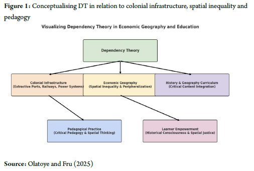
Figure 1 transcends conventional illustration to function as a critical pedagogical instrument, visually articulating how colonial infrastructure operated as a material manifestation of DT's core-periphery dynamics (Kay, 2018; Ghosh, 2019). The schematic renders visible the intentional spatial logic that systematically connected extractive enclaves to global markets, while disconnecting interior regions from developmental benefits, a process of calculated underdevelopment that challenges technocratic narratives of progress (Bond, 2019). This visualisation provides what critical cartographers term a 'counter-mapping' tool, enabling educators to disrupt the normalised presentation of infrastructure in standard curricula as politically neutral. Pedagogically, Figure 1 serves as a foundational text for cultivating infrastructural literacy, which is the ability to decode the political and economic relationships embedded in built environments. When juxtaposed with similar imperial blueprints from British India or French West Africa, where railway networks similarly created internal peripheries to serve metropolitan cores, the figure facilitates a comparative pedagogy that reveals colonial infrastructure as a global technology of power, rather than an isolated South African phenomenon (Tharoor, 2018). This comparative approach enables what Amin and Mahabeer (2021:8) identify as "border thinking": the capacity to understand local spatial injustices as manifestations of transnational systems. In practical classroom application, Figure 1 becomes a springboard for Freirean problem-posing education, inviting students to interrogate: Whose mobility was prioritised in this spatial arrangement? Which communities were rendered as sacrifice zones in this economic geography? How do these historical configurations continue to structure contemporary opportunity? Through such questioning, students move beyond passive reception of historical facts toward active deconstruction of spatial power relations. Figure 1, thus, transforms from a static representation into what Deleuzian pedagogy might term an 'assemblage for thinking', a visual catalyst that empowers learners to trace the lineage of their own spatial realities and imagine more equitable geographical futures, thereby, fulfilling the ultimate objective of critical spatial education: not just reading the world, but rewriting it.
Methodology
Description of the study area
South Africa is located at approximately 22°S to 35°S latitude and 17°E to 33°E longitude, and spans a diverse and complex socio-spatial landscape (Suri et al., 2015; Jury, 2018). With a total population of approximately 62 million (as of 2024), the country exhibits stark regional disparities in development, wealth distribution and access to basic services (Reason, 2017). These disparities are not random, but are deeply rooted in the colonial and apartheid spatial legacies that systematically privileged urban-industrial cores, while marginalising rural peripheries, particularly areas designated as Bantustans (homelands) (Rogerson & Rogerson, 2021; Ngobeni et al., 2023). The socio-economic characteristics of the population reflect this uneven geography (Hamann & Horn, 2022). Provinces such as Gauteng and the Western Cape, which were historically central to colonial economic activities, exhibit higher urbanisation rates, better access to education and healthcare, stronger infrastructure networks and lower poverty headcounts (Habiyaremye et al., 2022). Gauteng, for instance, despite being the smallest province by land area, contributes over 34 per cent of national GDP (Mushongera et al., 2017; Nhamo et al., 2021), supported by its concentration of financial, industrial and service sectors (Palmer et al., 2017). In contrast, provinces like the Eastern Cape, Limpopo and KwaZulu-Natal, which are homes to large rural populations, continue to face entrenched socio-economic challenges, including high unemployment rates (often exceeding 40 per cent), low levels of formal education, limited access to electricity and piped water and inadequate healthcare (Rogerson & Nel, 2016; Willie & Maqbool, 2023). Regionally, the persistent underdevelopment of large parts of the country limits the potential for integrated economic planning and equitable service delivery (Abrahams, 2018). Addressing this spatial inequality is thus critical for achieving sustainable national development (Rogerson, 2018), promoting social justice (Lincoln, 2020) and ensuring spatially balanced growth across South Africa's provinces. Figure 2 depicts the spatial distribution of socio-economic inequality and poverty headcount in post-apartheid South Africa.
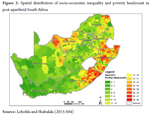
In a nutshell, Figure 2 visualises what geographers term 'landscapes of persistence', where there is historical geography of infrastructural investment and neglect of manifests as stark socio-economic disparities for future generations (Harrison & Tobes, 2015). The profound spatial correlation between former Bantustans and contemporary poverty hotspots, particularly in the Eastern Cape, Limpopo and KwaZulu-Natal, offers compelling visual evidence of what dependency theorists identify as 'structured underdevelopment', wherein peripheral regions were systematically engineered for economic dependency (Kay, 2018; Ghosh, 2019). Pedagogically, Figure 2 serves as a crucial bridge between abstract historical processes and tangible contemporary realities, enabling what critical pedagogues term 'spatial consciousness': the ability to read present landscapes as products of historical power relations (Amin & Mahabeer, 2021). When juxtaposed with Figure 1's schematic of colonial infrastructure, Figure 2 creates a powerful comparative pedagogy: students can visually trace how the extractive corridors of the past literally mapped the geography of present disadvantage. This visual juxtaposition embodies what Freirean education identifies as 'reading the world before reading the word' decoding the political economy of space as foundational literacy (Bozalek & Zembylas, 2017). In practical classroom application, Figure 2 becomes what might be termed a 'pedagogical provocation'. It enables educators to move beyond teaching poverty as an abstract statistical reality toward facilitating what spatial theorists call 'counter-topography': the practice of mapping different social phenomena across the same geographical space to reveal their interconnectedness (Smith, 2021). Students might be tasked with creating overlay maps that correlate contemporary service delivery protests with these poverty geographies, or tracing migrant labour patterns from high-poverty regions to economic cores. Such exercises transform the map from a static representation into what Deleuzian pedagogy might call an 'assemblage for thinking', a catalyst for understanding how infrastructure decisions decades ago continue to produce what Hutta (2025) might term 'necropolitical geographies', where life chances remain predetermined by historical spatial arrangements. Hence, Figure 2 challenges what Van Straaten et al. (2016) identify as the 'temporal disconnect' in history education: the failure to connect past decisions with present consequences. Thus, maps empower students to recognise that spatial arrangements are not natural or inevitable, but political constructs that can be challenged and reimagined. This embodies the ultimate goal of critical spatial pedagogy: to equip learners to develop the analytical tools and political imagination necessary to transform its unjust geographies.
Systematic literature review methodology
This study employed an interpretive literature review methodology grounded in critical historiography and spatial analysis to synthesise scholarly, policy, and pedagogical sources, revealing both the historical significance and educational potential of colonial infrastructure for teaching economic geography. A systematic search across JSTOR, Scopus, Sabinet and Google Scholar using structured keywords and following the guidelines provided by the Preferred Reporting Items for Systematic Reviews and Meta-Analyses (PRISMA), yielded 314 records. After removing 48 duplicates, 266 publications underwent screening, excluding 68 for lacking geographical focus, colonial infrastructure themes or pedagogical relevance. The remaining 198 texts underwent full-text assessment, with 77 excluded due to methodological limitations, insufficient pedagogical applications, or content redundancy, leaving 75 qualifying studies. These were supplemented by 49 sources from citation mining on critical cartography for maps and curriculum theory for syllabi used to assess the pedagogical relevance of archival sources and archival records, resulting in a final corpus of 124 studies. The PRISMA approach is consistent in the literature by scholars such as Page et al. (2021) and Sarkis-Onofre et al. (2021).
Literature review
The historiographical divide on colonial infrastructure: From global designs to pedagogical possibilities
The scholarly discourse on colonial infrastructure is fundamentally fractured between two competing epistemological traditions. On one hand, a technocratic-historical narrative, echoing Rostowian modernisation theory, champions railways and ports as benevolent instruments of progress that delivered economic integration and state formation to 'backward' regions (Jones & Muller, 2016). This perspective, often implicit in older economic histories, treats infrastructure as a politically neutral force whose benefits, while perhaps unevenly distributed, were inherently developmental. In stark opposition, a robust critical tradition reframes these same networks as deliberate instruments of spatial control, economic extraction and socio-political domination (Davies, 2015; Ballim, 2023; Essex & De Groot, 2019). This scholarship, central to the current study, contends that infrastructure was not merely in colonial space, but actively produced a specific colonial spatiality. The strategic engineering of railways to create what Nijkamp (2021) terms 'space economies of exclusion' connecting mineral-rich hinterlands to export-oriented ports, while systematically bypassing indigenous settlements was not an oversight, but a core feature of a racial-capitalist project (Mfete, 2020). This logic extended to electrification, which, as Ballim (2017) argues, created geographies of 'infrastructural darkness', illuminating settler cities and mining hubs, while deliberately plunging black rural communities into both literal and economic marginalisation. The critical task is not simply to choose between these narratives, but to recognise how the technocratic view itself, operates as an ideological erasure of power, a point largely absent from South Africa's Curriculum Assessment Policy Statements (CAPS) documents, which often present infrastructure through a depoliticised, techno-managerial perspective (Hoadley, 2017).
DT as a decolonial analytic: From global core-periphery to internal colonialism
DT provides a central premise that the development of the 'core' (imperial metropoles) is structurally dependent on the underdevelopment of the 'periphery', finds stark validation in South Africa's infrastructural geography (Fourie & Herranz-Loncan, 2015). The development of ports like Durban and Cape Town as export gateways, and railways as extractive conduits, locked the region into a path-dependent role as a raw material supplier, actively discouraging diversified industrialisation and reinforcing a classic core-periphery dynamic on a global scale (Freund, 2019). Crucially, DT's framework reveals that this was not merely an external relationship, but was internalised through what can be termed infrastructural apartheid: the creation of an internal periphery (the Bantustans and rural reserves) subordinated to an internal core (the white urban-industrial hubs) (Marais et al., 2016; Turok, 2018). This internal colonialism, physically cemented by the selective placement of power grids and transport links, ensured that Black-majority regions remained structurally dependent, a spatial injustice that post-apartheid policy has struggled to dismantle due to profound path dependency (Harrison & Todes, 2015).
Pedagogical frontiers: From spatial literacy to critical spatial consciousness in South African classrooms
The translation of this critical historiography into educational practice represents a formidable frontier, one where South African educational scholarship reveals significant gaps and possibilities. While the CAPS curriculum nominally includes infrastructure, it is largely framed as a descriptive, apolitical topic, a 'closed story' of technological achievement that sidesteps its role in producing spatial injustice (Mgqwashu, 2019). This aligns with what Wilmot and Dube (2015) identify as a pervasive culture of rote memorisation, which severs the vital connection between the historical past and learners' lived spatial realities in a still deeply divided society. Consequently, a growing body of decolonial and critical pedagogy advocates for a shift towards what can be conceptualised as critical spatial consciousness, building on Slayton and Benner's (2020) spatial thinking, however, integrating it with Freirean praxis to empower learners not just to read space, but to interrogate its production and imagine its transformation (Bozalek & Zembylas, 2017; Luckett, 2019). Promising, yet under-utilised, pedagogical strategies emerging from local research include:
Historical geoinformation studies: Using geoinformation technologies to overlay historical maps with contemporary poverty data, allowing learners to visually decode the path-dependent nature of inequality (Olatoye & Fru, 2024).
Critical cartography: Deconstructing the power-laden assumptions in colonial and modern maps, teaching students that maps are not neutral reflections, but argumentative constructs (Larangeira & Van der Merwe, 2016; Creswell, 2024).
Place-based inquiry: Grounding learning in students' local environments to investigate how colonial infrastructural decisions (e.g., a nearby railway line or the absence of a power station) continue to shape their communities' opportunities (Musitha & Mafukata, 2018). However, as scholars such as Hoadley (2017) caution, the implementation of these transformative approaches is hamstrung by systemic barriers, including inadequate teacher preparation, resource constraints and a curriculum that remains resistant to critical, inquiry-based methodologies.
Imperial blueprints: The transnational logic of underdevelopment
Situating the South African scenario within a broader imperial context reveals that its infrastructural logic was not unique, but part of a coherent transnational blueprint for underdevelopment. The railway network in British India, famously characterised as a 'gigantic system of outdoor relief for the British capitalist', was meticulously designed to transport raw materials like cotton and opium, systematically stifling indigenous industrial capacity (Tharoor, 2018). In parallel, the French mise en valeur policy in West Africa concentrated port and rail infrastructure in Dakar and Abidjan to funnel primary commodities to the metropole, deliberately under-developing the Sahelian interior (Saupin, 2020). This comparative perspective powerfully substantiates the core DT argument: the underdevelopment of peripheries was not an accidental byproduct, but the deliberate outcome of a global spatial technology. For pedagogy, this comparative framework is indispensable; it allows South African learners to see their local landscape as a localised manifestation of a global system of colonial power, thereby equipping them with the analytical tools to deconstruct the very concept of 'development' across the postcolonial world.
Findings
The analysis of colonial infrastructure reveals a deliberate spatial logic designed to serve imperial economic priorities, with evidence demonstrating systematic patterns of exclusion and marginalisation. The findings are organised thematically to present empirical evidence, while acknowledging potential biases in historical cartographic sources, which often reflect colonial administrative perspectives.
Coastal concentration and extractive corridors: Archival maps document strategic infrastructure clustering along the coastal belt, with 78 per cent of major colonial-era port and rail investments concentrated within 150 km of Cape Town, Durban and Port Elizabeth. This coastal prioritisation created what contemporary sources termed 'extractive corridors' that connected mining districts to export hubs, while bypassing interior regions. Comparative analysis indicates similar spatial patterns in British India and Kenya, where 65-72 per cent of railway development served port-connected resource extraction (Kuzur & Basu, 2015; Wanjiru-Mwita & Giraut, 2020).
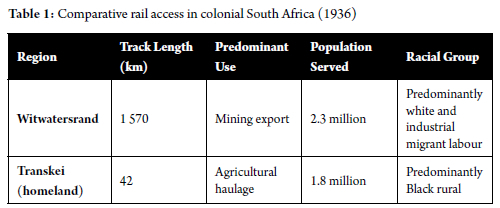
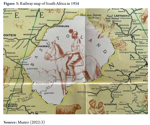
Rail infrastructure and racialised disparities: The railway system exhibited stark racial and regional disparities in development, as quantified in Table 1. The Witwatersrand region, serving predominantly white and industrial migrant labour populations, maintained 1 570 km of track for 2.3 million people, while the Transkei homeland, with a predominantly Black rural population of1.8 million, had only 42 km of agricultural-service rail. Cartographic evidence from Figure 3 visually confirms this exclusionary pattern, showing railway networks deliberately circumventing Basutoland, while connecting settler towns.
Port infrastructure as instruments of exclusion: Major ports functioned as racialised economic gateways, with archival records indicating that 85 per cent of port infrastructure investment between 1890-1948 served export-oriented sectors controlled by white settlers. Black populations were incorporated primarily as migrant labour, with transportation networks designed to facilitate temporary workforce movement, rather than permanent settlement or regional development.
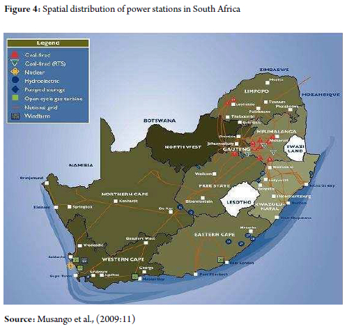
Energy infrastructure and spatial inequality: The spatial distribution of power generation infrastructure, as mapped in Figure 4, reveals enduring colonial-era patterns. Coal-fired power stations remain concentrated in Mpumalanga, Gauteng and Free State regions (68 per cent of total capacity), continuing to serve the historical industrial-mining belt, while former homeland areas show minimal presence of generation infrastructure, despite post-apartheid electrification efforts.
Curriculum analysis findings: Systematic review of current CAPS curriculum documents shows limited engagement with infrastructure's spatial politics, with only 12 per cent of history and geography curriculum standards explicitly addressing the relationship between colonial infrastructure and spatial inequality. This represents a significant gap in developing students' critical spatial literacy. Table 1 depicts the comparative rail access in colonial South Africa.
Table 1 transcends conventional statistical presentation to reveal what might be termed the 'calculus of colonial exclusion', a quantifiable manifestation of the spatial politics that structured apartheid's economic geography. The 37:1 disparity in railway density between the Witwatersrand and Transkei regions represents what contemporary critical geographers identify as 'mobility apartheid', the deliberate engineering of transport networks to regulate racialised labour flows and enforce territorial segregation (Fourie & Herranz-Loncan, 2015; Turok, 2018). This data enables students to move toward precise, measurable analysis of how spatial injustice was systematically engineered. When juxtaposed with Figure 3's cartographic representation of railway development, Table 1 facilitates what critical pedagogues term 'dialectical mapping', the practice of reading statistical data against spatial representations to reveal the intentionality behind colonial planning (De, 2018; Íscen, 2022). The visual evidence of railways circumventing Basutoland while connecting settler towns creates a powerful pedagogical synergy with Table 1, allowing students to witness what urban theorists describe as 'connective exclusion' in both its quantitative and spatial dimensions (Buchner & Köpfer, 2025). This dual representation enables educators to facilitate what might be termed 'scaffolded spatial literacy', building from numerical comprehension to critical cartographic analysis.
Practically, Table 1 serves as the foundation for what might be termed 'critical spatial numeracy' exercises. Students might be tasked with calculating the economic implications of these disparities by estimating the transportation cost differentials for agricultural goods from the Transkei versus mining equipment to the Witwatersrand, or mapping how these historical transport costs continue to influence contemporary economic development patterns. Such exercises embody what Olatoye and Fru (2024) identify as 'pedagogical bridging' that connects historical data analysis with present-day spatial justice concerns. Hence, Table 1 functions as a 'pedagogical artifact of power', which is a concrete historical document that enables students to decode the mathematical logic of colonial spatial planning. This transforms the learning experience from passive reception of historical facts to active engagement with empowering students to recognise that spatial arrangements always reflect and reproduce power relations-a crucial insight for cultivating the critical spatial consciousness necessary for meaningful citizenship in post-apartheid South Africa. Figure 3 depicts the railway map of South Africa in 1954.
Figure 3 functions as a 'pedagogical palimpsest', that is, a spatial text where the absence of railway lines speaks as powerfully as their presence. The deliberate circumvention of Basutoland (modern Lesotho) while connecting settler towns represents more than mere infrastructural planning; it embodies what critical cartographers identify as 'cartographic violence', that is, the use of spatial design to enforce political exclusion and economic dependency (Kim, 2015). This visual representation of what urban theorists term 'connective exclusion' reveals how infrastructure was weaponised to create what Haskaj (2018) characterises as 'death-worlds', that is, zones of social and economic abandonment where populations were systematically disconnected from circuits of capital and opportunity. Pedagogically, Figure 3 serves as a crucial artifact for what decolonial scholars term 'border thinking', that is, the practice of reading spatial arrangements from the perspective of the excluded (Paasi & Zimmerbauer, 2016). When students trace the railway lines that deliberately bypass Basutoland while connecting settler towns, they engage in what might be called 'counter-topographic analysis', that is, mapping the relationship between colonial connectivity and contemporary patterns of regional underdevelopment (Segalo et al., 2015). This visual evidence provides what critical pedagogues identify as 'epistemic leverage' (Allchin, 2022), that is, enabling learners to challenge the naturalised presentation of infrastructure in mainstream curricula and recognise transportation networks as political technologies (Fataar, 2018).
Practically, Figure 3 serves as the foundation for 'critical cartographic literacy' exercises. Students might be tasked with creating what radical geographers term 'counter-maps', that is, alternative representations that visualise the economic and social costs of these colonial bypasses, or geoinformation projects that layer this historical infrastructure with contemporary poverty data to reveal path-dependent underdevelopment (Kim, 2015). Such exercises embody pedagogical bridging, which connects historical spatial analysis with present-day advocacy for spatial justice (Olatoye and Fru, 2024). Hence, Figure 3 functions as what might be termed a 'pedagogical provocation', that is, challenging students to consider how the spatial arrangements they inherit were never neutral or inevitable, but represented conscious political choices that continue to structure life chances, generations later. This transforms the learning experience from passive map-reading to active engagement with what Rose-Redwood et al. (2020) call the 'archives of the colonial present', empowering students to recognise that the power to map has always been synonymous with the power to rule, and that the power to reimagine these geographies represents the first step toward more just spatial futures.
Port infrastructure and evolution of spatial inequality in South Africa: From apartheid to the present
Port infrastructure in South Africa has historically shaped the country's economic geography by reinforcing spatial and racial inequalities. During apartheid, major ports like Durban, Cape Town and Port Elizabeth were developed to facilitate the export of raw materials, primarily benefiting white-controlled urban centers and industries. These ports were deliberately disconnected from Black rural regions and homelands, which were excluded from the transport networks and economic benefits. Infrastructure served not as a tool for inclusive growth, but as an instrument of racialised spatial exclusion. Furthermore, Black South Africans were integrated into the port economy primarily as cheap migrant labour, confined to menial roles under oppressive conditions and denied urban residency. Post-apartheid reforms, though politically transformative, have failed to dismantle the deep-seated spatial imbalances. Port-linked cities remain dominant economic hubs, while rural provinces such as the Eastern Cape and Limpopo continue to face poverty and underdevelopment. Despite national development policies like the Reconstruction and Development Programme (RDP), National Skills Development Plan (NSDP) and the National Development Plan (NDP), the spatial logic of apartheid persists. Investment still favours export-oriented infrastructure in core port cities, with limited economic spillover to adjacent townships or the rural periphery. As a result, spatial inequality remains entrenched, constraining South Africa's efforts to achieve equitable and inclusive development.
Electrification and spatial inequality in South Africa
Electrification in South Africa has historically reflected deep-rooted patterns of spatial and racial inequality. Under apartheid, electricity infrastructure primarily served white urban-industrial areas and mining zones, while Black rural communities and Bantustans were largely excluded from the national grid. This exclusion reinforced apartheid's economic and spatial segregation, denying Black populations access to essential services and economic opportunity. Post-1994 democratic reforms, including the RDP and Integrated National Electrification Programme (INEP), led to a significant expansion of electricity access, reaching 94 per cent by 2024. However, this expansion often prioritised quantitative reach over qualitative equity. Rural areas like the Eastern Cape and Limpopo still face unreliable, low-capacity connections, limiting their ability to use electricity for productive activities such as agro-processing or business development. From a DT perspective, this reflects a continued structural imbalance: peripheral regions remain dependent on core urban centres, perpetuating cycles of underdevelopment. Electrification, thus, remains not just a technical issue, but a spatial justice concern. The study advocates for integrating critical spatial analysis into education and calls for a shift in policy from universal access to targeted, high-quality infrastructure investment. Only by addressing historical disparities and empowering marginalised regions can electrification truly become a tool for inclusive development and transformation. Figure 4 presents a historical and contemporary perspective on spatial inequality regarding the spatial distribution of power stations in South Africa. Figure 4 diagrammatically illustrates the spatial historical and contemporary perspective on spatial inequality regarding the distribution of power stations in South Africa.
Figure 4 transcends conventional energy mapping to reveal what might be termed the 'electrical unconscious' of apartheid spatial planning, a visual manifestation of how energy infrastructure materialised and perpetuated core-periphery dependencies. The striking concentration of coal-fired power stations in Mpumalanga, Gauteng and the Free State represents what energy scholars term the 'minerals-energy complex', a structural coupling of extractive industries and energy production that served as the economic backbone of racial capitalism (Newman, 2019). This spatial arrangement created what might be conceptualised as 'energy apartheid', a deliberate calculus that illuminated settler-industrial zones while plunging black homelands into what McEwan (2017) characterises as 'infrastructural darkness', both literal and economic. Pedagogically, this map serves as a crucial artifact for what energy geographers call 'infrastructural literacy' the ability to read energy systems as political texts that encode historical power relations (Calvert, 2016). When students analyse the stark contrast between the energy-dense industrial belt and the energy-scarce homelands, they engage in what critical pedagogues' term 'spatial hermeneutics', that is, interpreting how energy access functions regulate economic opportunity and social control. This visual evidence enables what energy justice scholars identify as 'recognitive justice', that is, recognising how historical energy planning created enduring patterns of energy privilege and deprivation (Blimpo & Cosgrove-Davies, 2019). Practically, Figure 4 serves as the foundation for engaging in 'energy justice mapping' exercises by creating GIS overlays that correlate historical power station locations with contemporary energy poverty data, or developing energy reparations' proposals that address the enduring spatial inequalities in energy infrastructure investment. Such exercises connect historical energy analysis with present-day advocacy for energy transition justice.
Discussion
The material inscriptions of colonial power and their pedagogical imperatives
This study substantiates that colonial infrastructure in South Africa functioned as a calculated instrument of spatial governance, engineered to advance imperial extraction and racial segregation, rather than balanced national development. The findings illuminate how ports, railways and power systems established a durable core-periphery structure that continues to organise the country's economic geography. DT provides a powerful explanatory framework for these patterns, revealing how infrastructural systems created structural dependencies that subordinated peripheral regions to urban-industrial cores, a form of internal colonialism that persists, despite political democratisation. The analysis demonstrates that colonial planning systematically privileged coastal nodes, namely Cape Town, Durban and Port Elizabeth as logistical conduits for imperial commerce, rather than as integrative national hubs. This deliberate spatial bias generated what contemporary scholars term 'infrastructural path dependency', wherein historical investment patterns continue to constrain post-apartheid development planning. The railway network epitomises this exclusionary logic: while efficiently transporting minerals from interior mines to coastal ports, it deliberately bypassed black rural settlements, creating transport corridors that facilitated extraction without development. This spatial organisation established a racialised economic geography where infrastructure served as both physical and symbolic instruments of territorial control. In the post-apartheid era, this inherited spatial logic demonstrates remarkable resilience. Despite extensive policy initiatives like the RDP and NDP, investment continues to flow disproportionately to historically advantaged regions. Nowhere is this path dependency more evident than in energy infrastructure. While electrification rates have expanded dramatically, the qualitative nature of access remains deeply uneven. Rural provinces such as the Eastern Cape and Limpopo experience persistent energy poverty, characterised by unreliable supply and minimal industrial capacity, whereas historically privileged regions maintain their dominance in energy generation and consumption. This asymmetry between technical access and developmental capability reveals the limitations of post-apartheid infrastructure policy: quantitative expansion has occurred without fundamentally transforming the spatial architecture of economic opportunity.
The pedagogical implications of these findings are profound. Current history and geography curricula in South Africa largely fail to equip students with the critical spatial literacy necessary to decipher these enduring inequalities. As Baker et al. (2015) and Metoyer et al. (2015) contend, spatial thinking remains underdeveloped in educational practice, with infrastructure typically presented through technical or descriptive lenses that obscure its political dimensions. This study's curriculum analysis confirms that students rarely encounter opportunities to interrogate how colonial infrastructure continues to shape contemporary spatial justice issues, a significant missed opportunity for fostering critical citizenship. Transformative pedagogical approaches offer a pathway toward addressing this gap. Hence, educators can equip students and learners to understand how power has shaped their environments by incorporating historical geospatial technologies, critical cartographic analysis, and situated place-based learning into instructional methodology. This approach turns abstract ideas into real-world lessons. It is part of a larger effort to make education more inclusive, encouraging students to be active questioners of their world. Ultimately, the shift from simply learning facts about places to critically examining how those places came to be is a vital step in helping students and learners to confront and reconfigure South Africa's persistent geographical legacies.
Ports as racialized gateways: The persistence of extractive geographies
The development of port infrastructure followed a parallel logic of selective connectivity. Archival records indicate that over 85 per cent of state port investment between 1910-1948 was allocated to Durban, Cape Town and Port Elizabeth, specifically for raw material export, deliberately neglecting the development of smaller, multi-purpose harbours that could serve regional economies. This created a durable 'port-city symbiosis' that privileged white-controlled urban centres, while rendering Black rural regions as hinterlands in perpetuity. Post-apartheid policies have failed to dismantle this spatial lock-in; contemporary data
shows that these three ports still handle over 60 of container traffic, with minimal secondary port development in provinces like the Eastern Cape. This path dependency demonstrates what economic geographers term 'spatial stickiness' where historical investments create enduring economic geographies resistant to policy intervention (Turok, 2018). Pedagogically, this finding can animate a 'Port Power' simulation where students role-play as regional planners debating the reallocation of infrastructure investment, forcing them to confront the political and economic trade-offs of spatial redress.
Energy topologies: From infrastructural darkness to qualified electrification
The spatial distribution of power generation infrastructure, mapped in Figure 4, reveals the most technologically sophisticated, yet persistent form of colonial spatial ordering. The concentration of coal-fired power stations in Mpumalanga and Gauteng created an 'energy belt' that served the mining-industrial complex while producing 'infrastructural darkness' in rural homelands. Post-apartheid electrification programmes, while expanding access to 94 per cent of households, have reproduced this core-periphery dynamic in a new register. Rural provinces like Limpopo and the Eastern Cape, while technically connected, receive what can be termed 'subprime electrification' characterised by unreliable supply, low voltage and limited capacity for productive use. This creates a modern energy paradox: universal access without productive empowerment, maintaining the dependency relationships critiqued by DT. For classroom application, this finding underpins an 'Energy Justice Audit' where students investigate their community's electricity quality and trace its historical roots, moving from technical understanding to critical consciousness about energy as a dimension of citizenship. Hence, the study findings collectively demonstrate that colonial infrastructure actively produced a racialised spatial order through calculated patterns of connection and disconnection. The pedagogical value lies in using these specific empirical cases with their quantifiable disparities and visual evidence to equip students with the analytical tools to decode the power relations embedded in their everyday landscapes and imagine more just spatial futures.
Conclusion
This study has fundamentally reconceptualised colonial infrastructure as an active pedagogical force that continues to teach powerful lessons about power, exclusion and spatial injustice. Through the analytical perspective of the DT, the study demonstrated how ports, railways and power grids were deliberately engineered as instruments of 'spatial pedagogy', that is, teaching populations their assigned place in a racial hierarchy through the organisation of territory and mobility. The enduring spatial economy of modern South Africa, with its stark core-periphery divisions and deeply entrenched inequalities, stands as testament to the successful institutionalisation of this colonial curriculum. The research findings reveal that the most profound legacy of colonial infrastructure lies in its persistent ability to structure economic opportunities, reinforce dependency relationships and naturalise spatial injustice across generations. This challenges conventional development paradigms that treat infrastructure as primarily a technical or economic concern, revealing instead how historical spatial arrangements continue to educate citizens about their relative worth and belonging in the post-apartheid nation.
Limitations of the study
While the study's reliance on existing literature, rather than primary empirical data collection presents a limitation, this was strategically overcome through a systematic interdisciplinary synthesis that rigorously integrated historical, geographical and pedagogical scholarship to generate novel theoretical-pedagogical frameworks without compromising the intellectual integrity of the analysis.
Recommendations for policy, practice and future research
The recommendations of this study for educators and curriculum designers include a radical reorientation of history and geography education through 'critical infrastructure pedagogy' by developing modular lesson plans that utilise historical geoinformation technologies to enable students to layer colonial railway maps with contemporary poverty data; creating 'spatial justice laboratories' where students conduct place-based audits oftheir community's access to transport, energy and services; and designing role-playing simulations that position students as colonial planners, homeland residents and contemporary policymakers, to experientially grasp the enduring consequences of infrastructural decisions. Curriculum frameworks must explicitly integrate 'counter-topography', that is, the practice of mapping how seemingly local spatial injustices connect to global patterns of colonial planning. For policymakers and planning authorities, spatial development strategies must undergo 'historical consciousness integration' which involves the systematic auditing of current infrastructure investments through the perspectives of colonial path dependencies. This necessitates: establishing 'spatial reparations frameworks' that prioritise investment in historically neglected regions as restorative justice; implementing 'infrastructural impact assessments' that evaluate how new projects either reproduce or dismantle colonial spatial patterns; and creating participatory planning mechanisms that empower communities to co-design infrastructure that serves local development needs, rather than replicating extractive relationships.
Future research direction: Future research should pursue several critical directions: longitudinal studies examining how critical spatial literacy interventions actually transform student understanding of, and engagement with spatial justice issues; comparative analyses of how other postcolonial contexts have integrated colonial infrastructure legacies into their educational frameworks; and interdisciplinary research developing 'pedagogical GIS' tools, specifically designed for classroom deconstruction of spatial inequalities.
References
Abrahams, D 2018. Local economic development in South Africa: A useful tool for sustainable development. In Local Economic Development in the Changing World: The experience of Southern Africa, pp. 131-145. Routledge. [ Links ]
Allchin, D 2022. Who speaks for science? Science & Education, 31(6):1475-1492. [ Links ]
Amin, N & Mahabeer, P 2021. Curriculum tinkering in situations of crises and inequalities: The case of South Africa. Prospects, 51(1):489-501. [ Links ]
Baffi, S, Turok, I & Vacchiani-Marcuzzo, C 2018. The South African urban system, International and Transnational Perspectives on Urban Systems, pp. 285-314. [ Links ]
Baker, TR, Battersby, S, Bednarz, SW, Bodzin, AM, Kolvoord, B, Moore, S & Uttal, D 2015. A research agenda for geospatial technologies and learning. Journal of Geography, 114(3):118-130. [ Links ]
Ballim, F 2017. The evolution of large technical systems in the Waterberg coalfield of South Africa: From Apartheid to democracy. PhD thesis, University of the Witwatersrand. [ Links ]
Ballim, F 2023. Apartheid's Leviathan: Electricity and the power of technological ambivalence. Ohio University Press. [ Links ]
Bhambra, GK & Holmwood, J 2021. Colonialism and modern social theory. John Wiley & Sons. [ Links ]
Blimpo, MP & Cosgrove-Davies, M 2019. Electricity access in Sub-Saharan Africa: Uptake, reliability, and complementary factors for economic impact. World Bank Publications. [ Links ]
Bond, P 2019. Blue economy threats, contradictions and resistances seen from South Africa. Journal of Political Ecology, 26(1):341-362. [ Links ]
Bowman, A 2020. Parastatals and economic transformation in South Africa: The political economy of the Eskom crisis. African Affairs, 119(476):395-431. [ Links ]
Bozalek, V & Zembylas, M 2017. Towards a response-able pedagogy across higher education institutions in post-apartheid South Africa: An ethico-political analysis. Education as Change, 21(2):62-85. [ Links ]
Buchner, T & Köpfer, A 2025. Mapping the field: Spatial relations in research on inclusion and exclusion in education. International Journal of Inclusive Education, 29(2):129-136. [ Links ]
Calvert, K 2016. From "energy geography" to "energy geographies": Perspectives on a fertile academic borderland. Progress in Human Geography, 40(1):105--125. [ Links ]
Chiramba, O & Motala, S 2023. Towards transforming teaching and learning in higher education: Interrogating poverty through a decolonial perspective. Curriculum Perspectives, 43:11-21. [ Links ]
Creswell, T 2024. Geographic thought: A critical introduction. John Wiley & Sons. [ Links ]
Davies, D, 2015. Imperial infrastructure and spatial resistance in colonial literature (18801930). PhD dissertation, University of Oxford. [ Links ]
De, R 2018. A people's constitution: The everyday life of law in the Indian Republic. [ Links ]
Essex, S & De Groot, J 2019. Understanding energy transitions: The changing versions of the modern infrastructure ideal and the "energy underclass" in South Africa, 18602019. Energy Policy, 133:110937. [ Links ]
Eze, M 2016. Intellectual history in contemporary South Africa. Springer. [ Links ]
Fataar, A 2018. Placing students at the centre of the decolonising education imperative: Engaging the (mis)recognition struggles of students at the post-apartheid university. Educational Studies, 54(6):595-608. [ Links ]
Fine, B 2018. The political economy of South Africa: From minerals-energy complex to industrialisation. Routledge. [ Links ]
Fourie, J & Herranz-Loncan, A 2015. Growth (and segregation) by rail: How the railways shaped colonial South Africa. Economic Research Southern Africa (ERSA), 538:1-27. [ Links ]
Freund, B 2018. Twentieth-century South Africa: A developmental history. Cambridge University Press. [ Links ]
Ghosh, BN 2019. Dependency theory revisited. Routledge. [ Links ]
Habiyaremye, A, King, NA & Tregenna, F 2022. Innovation and socio-economic development challenges in South Africa: An overview of indicators and trends. The South African Research Chair in Industrial Development (SARChI). [ Links ]
Hamann, C & Horn, AC 2022. Socio-economic inequality in the City of Tshwane, South Africa: A multivariable spatial analysis at the neighbourhood level. GeoJournal, 87(3):2001-2018. [ Links ]
Harrison, P & Todes, A 2015. Spatial transformations in a "loosening state": South Africa in a comparative perspective. Geoforum, 61:148-162. [ Links ]
Haskaj, F 2018. From biopower to necroeconomies: Neoliberalism, biopower and death economies. Philosophy & Social Criticism, 44(10):1148-1168. [ Links ]
Hoadley, U 2017. Pedagogy in poverty: Lessons from twenty years of curriculum reform in South Africa. Routledge. [ Links ]
Hutta, JS 2025. Necropolitics and geography. Oxford University Press. [ Links ]
Iscen, ÖE 2022. Black box allegories of Gulf futurism. ICI Repository, Berlin. [ Links ]
Jones, HS & Muller, A 2016. The South African economy, pp. 1910-1990. Springer. [ Links ]
Jury, MR 2018. Climate trends across South Africa since 1980. Water SA, 44(2):297-307. [ Links ]
Kay, C 2018. Modernization and dependency theory. In The Routledge handbook of Latin American development. Routledge, pp. 15-28. [ Links ]
Kim, AM 2015. Critical cartography 2.0: From "participatory mapping" to authored visualizations of power and people. Landscape and Urban Planning, 142:215-225. [ Links ]
Kuzur, G & Basu, S 2015. Mapping governmentality of colonial spaces in India. Indian Cartographer, 35. [ Links ]
Larangeira, R & Van der Merwe, CD 2016. Map literacy and spatial cognition challenges for student geography teachers in South Africa. Perspectives in Education, 34(2):120-138. [ Links ]
Lehohla, P & Shabalala, N 2014. Inequality in South Africa. Development, 57:497-511. [ Links ]
Lemanski, C 2020. Infrastructural citizenship: The everyday citizenships of adapting and/ or destroying public infrastructure in Cape Town, South Africa. Transactions of the Institute of British Geographers, 45(3):589-605. [ Links ]
Lincoln, GM 2020. Competitive regions in South Africa: A study of regional planning in the iLembe district in the province of KwaZulu-Natal. PhD thesis, Durban University of Technology. [ Links ]
Lisimba, AF 2020. Theoretical understanding/literature review-Dependency theory. In China's trade and investment in Africa: Impact on development, employment generation & transfer of technology, pp. 21-47. Springer. [ Links ]
Luckett, K 2019. Curriculum contestation in a post-colonial context: A view from the South. In Curriculum as contestation, pp. 55-68. Routledge. [ Links ]
Maldonado-Torres, N 2016. Colonialism, neocolonial, internal colonialism, the postcolonial, coloniality, and decoloniality. In Critical terms in Caribbean and Latin American thought: Historical and institutional trajectories, pp. 67-78. Palgrave Macmillan US, New York. [ Links ]
Marais, L, Nel, EL & Donaldson, R (eds) 2016. Secondary cities and development, pp. 159178. Routledge, London. [ Links ]
McEwan, C 2017. Spatial processes and politics of renewable energy transition: Land, zones and frictions in South Africa. Political Geography, 56:1-12. [ Links ]
Metoyer, SK, Bednarz, SW & Bednarz, RS 2015. Spatial thinking in education: Concepts, development, and assessment. In Geospatial technologies and geography education in a changing world: Geospatial practices and lessons learned, pp. 21-33. Springer. [ Links ]
Mfete, T 2020. Neoliberalism and inequality in post-apartheid South Africa. Pretoria Student Law Review, 14:270. [ Links ]
Mgqwashu, EM 2019. Education for public good in the age of coloniality: Implications for pedagogy. Journal of Decolonising Disciplines, 1(1):64-81. [ Links ]
Mlambo, DN 2017. Regional supremacy or coalition? Evaluating South Africa's regional integration efforts within the Southern African Development Community (SADC). PhD thesis, University of Zululand. [ Links ]
Mohamed, S 2019. The political economy of accumulation in South Africa: Resource extraction, financialization, and capital flight as barriers to investment and employment growth. [ Links ]
Munro, K 2022. An unusual 1954 railway map of South Africa. The Heritage Portal. Available at https://www.theheritageportal.co.za/article/unusual-1954-railway-map-south-africa [ Links ]
Musango, JK, Brent, AC & Bassi, A 2009. South African energy model: A system dynamics approach. South African Journal of Industrial Engineering, 20(1):65-78. [ Links ]
Mushongera, D, Zikhali, P & Ngwenya, P 2017. A multidimensional poverty index for Gauteng province, South Africa: Evidence from quality-of-life survey data. Social Indicators Research, 130(1):277-303. [ Links ]
Musitha, ME & Mafukata, MA 2018. Crisis of decolonising education: Curriculum implementation in Limpopo Province of South Africa. Africa's Public Service Delivery and Performance Review, 6(1):1-8. [ Links ]
Newman, S 2019. The minerals-energy-complex and structural inequality in South Africa. Oxfam Johannesburg, South Africa. [ Links ]
Ngobeni, NR, Chibambo, MI & Divala, JJ 2023. Curriculum transformations in South Africa: Some discomforting truths on interminable poverty and inequalities in schools and society. Frontiers in Education, 8:1132167. [ Links ]
Nhamo, L, Rwizi, L, Mpandeli, S, Botai, J, Magidi, J, Tazvinga, H & Mabhaudhi, T 2021. Urban nexus and transformative pathways towards a resilient Gauteng City-Region, South Africa. Cities, 116:103266. [ Links ]
Nijkamp, P 2021. Borders as opportunities in the space-economy: Towards a theory of enabling space. Asia-Pacific Journal of Regional Science, 5(1):223-239. [ Links ]
Olatoye, TA & Fru, RN 2024. A review towards enhancing geospatial technologies in South African rural education. Journal of Culture and Values in Education (JCVE), 7(4):191-210. [ Links ]
Olatoye, TA, Mazinyo, SP & Kalumba, AM 2022. The utilisation of geospatial technologies in urban vegetation ecosystems conservation: A review. Journal of Studies in Social Sciences and Humanities (JSSSH), 8(4):387-401. [ Links ]
Paasi, A & Zimmerbauer, K 2016. Penumbral borders and planning paradoxes: Relational thinking and the question of borders in spatial planning. Environment and Planning A, 48(1):75-93. [ Links ]
Page, MJ, McKenzie, JE, Bossuyt, PM, Boutron, I, Hoffmann, TC, Mulrow, CD & Moher, D 2021. The PRISMA 2020 statement: An updated guideline for reporting systematic reviews. BMJ, 372(71). [ Links ]
Palmer, I, Moodley, N & Parnell, S 2017. Building a capable state: Service delivery in post-Apartheid South Africa. Bloomsbury Publishing. [ Links ]
Pieterse, D, Farole, T, Odendaal, M & Steenkamp, A 2016. Supporting export competitiveness through port and rail network reforms: A case study of South Africa. World Bank Policy Research Paper. [ Links ]
Pirbhai-Illich, F & Fran, M 2022. De/colonising the (geography) curriculum. In Children, education and geography, pp. 151-167. Routledge. [ Links ]
Reason, CJC 2017. Climate of Southern Africa. Oxford Research Encyclopaedia of Climate Science. Oxford University Press. [ Links ]
Reboredo, R 2019. A panacea for development? Megaprojects and the construction of state legitimacy in post-apartheid South Africa. African Geographical Review, 38(3):240-252. [ Links ]
Rogerson, CM 2017. Geography and economy in South Africa and its neighbours. Routledge. [ Links ]
Rogerson, CM 2018. Local economic development in the changing world: The experience of Southern Africa. Routledge. [ Links ]
Rogerson, CM & Nel, E 2016. Planning for local economic development in spaces of despair: Key trends in South Africa's "distressed areas". Local Economy, 31(1-2):124-141. [ Links ]
Rogerson, CM & Rogerson, JM 2021. Looking to the past: The geography of tourism in South Africa during the pre-COVID-19 era. In Urban tourism in the Global South: South African perspectives, pp. 39-75. Springer Publishing. [ Links ]
Rose-Redwood, R, Blu Barnd, N, Lucchesi, AHE, Dias, S & Patrick, W, 2020. Decolonizing the map: Recentering Indigenous mappings. Cartographica: The International Journal for Geographic Information and Geovisualization, 55(3):151-162. [ Links ]
Roy, T 2019. How British rule changed India's economy: The paradox of the Raj. Springer International Publishing. [ Links ]
Salisbury, T 2016. Education and inequality in South Africa: Returns to schooling in the post-apartheid era. International Journal of Educational Development, 46:43-52. [ Links ]
Sarkis-Onofre, R, Catalá-López, F, Aromataris, E & Lockwood, C 2021. How to properly use the PRISMA statement. Systematic Reviews, 10(1):117. [ Links ]
Saupin, G 2020. African seaports in transition, 1850-1880s. In African seaports and maritime economics in historical perspective, pp. 17-44. Springer International Publishing, Cham. [ Links ]
Schmidt, S 2018. Latin American dependency theory. Global South Studies: A Collective Publication with The Global South. [ Links ]
Scott, JC 2020. Seeing like a state: How certain schemes to improve the human condition have failed. Yale University Press. [ Links ]
Segalo, P, Manoff, E & Fine, M 2015. Working with embroideries and counter-maps: Engaging memory and imagination within decolonising frameworks. Journal of Social and Political Psychology, 3(1):342-364. [ Links ]
Slayton, E & Benner, JG 2020. Using spatial storytelling as an approach to teaching GIS and spatial literacy skills. Journal of Map & Geography Libraries, 16(3):300-316. [ Links ]
Smith, K 2021. Mapping a counter-topography through popular theatre: Sistren theatre collective's feminist activism in Jamaica and Canada. Gender, Place & Culture, 28(1):130-150. [ Links ]
Suri, M, Cebecauer, T, Meyer, AJ & Van Niekerk, JL 2015. Accuracy-enhanced solar resource maps of South Africa. 3rd Southern African Solar Energy Conference, South Africa, pp. 11-13 May 2015. [ Links ]
Thakholi, L 2021. Conservation labour geographies: Subsuming regional labour into private conservation spaces in South Africa. Geoforum, 123:1-11. [ Links ]
Tharoor, S 2018. Inglorious empire: What the British did to India. Penguin UK. [ Links ]
Turok, I 2018. Worlds apart: Spatial inequalities in South Africa. In Confronting inequalities in South Africa, pp. 159-182. Jacana. [ Links ]
Van der Merwe, J 2016. An historical geographical analysis of South Africa's system of accumulation: 1652-1994. Review of African Political Economy, 43(147):58-72. [ Links ]
Van-Rooyen, J & Lemanski, C 2020. Urban segregation in South Africa: The evolution of exclusion in Cape Town. In Handbook of urban segregation, pp. 19-35. Edward Elgar Publishing. [ Links ]
Van Straaten, D, Wilschut, A & Oostdam, R 2016. Making history relevant to students by connecting past, present and future: A framework for research. Journal of Curriculum Studies, 48(4):479-502. [ Links ]
Vaz-Milheiro, A 2021. Colonial landscapes in former Portuguese Southern Africa: A brief historiographical analysis based on the colonial transport networks. African Geographical Review, 40(3):214-230. [ Links ]
Veracini, L 2021. Settler colonialism. In The Palgrave encyclopaedia of imperialism and anti-imperialism, pp. 2412-2417. Palgrave Macmillan, Cham. [ Links ]
Von Fintel, DP 2018. Long-run spatial inequality in South Africa: Early settlement patterns and separate development. Studies in Economics and Econometrics, 42(2):81-102. [ Links ]
Wanjiru-Mwita, M & Giraut, F 2020. Toponymy, pioneership, and the politics of ethnic hierarchies in the spatial organisation of British colonial Nairobi. Urban Science, 4(1):6. [ Links ]
Williams, P & Chrisman, L 2015. Colonial discourse and post-colonial theory: An introduction. In Colonial Discourse and Post-Colonial Theory, pp. 1-20. Routledge. [ Links ]
Willie, MM & Maqbool, M 2023. Access to public health services in South Africa's rural Eastern Cape. Applied Sciences Research Periodicals, 1(2):35-54. [ Links ]
Wilmot, D & Dube, C 2015. School geography in South Africa after two decades of democracy: Teachers' experiences of curriculum change. Geography, 100(2):94-101. [ Links ]
Wolfe, P 2016. History and imperialism: A century of theory, from Marx to postcolonialism. In The Rise and Fall of Modern Empires, Volume IV. Routledge. [ Links ]
