


Services on Demand
Journal

Article
 English (pdf)
 Article in xml format
 Article references
 Send this article by e-mail
Indicators
Related links
-
 Cited by Google
 -
 Similars in Google
Share

 Permalink
South African Journal of Science
On-line version ISSN 1996-7489Print version ISSN 0038-2353
S. Afr. j. sci. vol.122 n.1-2 Pretoria Jan./Feb. 2026
https://doi.org/10.17159/sajs.2026/22809
RESEARCH ARTICLE
Cretaceous dinosaur tracks in the Brenton Formation, Western Cape
Charles W. HelmI, II; Mark G. DixonI; Willo M. StearI; Fred van BerkelI
IAfrican Centre for Coastal Palaeoscience, Nelson Mandela University, George, South Africa
IITumbler Ridge Museum, Tumbler Ridge, British Columbia, Canada
ABSTRACT
Dinosaur tracks, probably aged -132 Ma, have been identified in South Africa's Western Cape Province, where they occur within the Brenton Formation of the Cretaceous Uitenhage Group. At least one dinosaur bone has previously been identified from the Brenton Formation. Tracks are evident both in profile in low cliff exposures and as pedestalled surface tracks or penetrative undertracks on a mudstone/siltstone surface that is ephemerally exposed within an intertidal zone. The trackmaker assemblage is interpreted to include theropods, possibly ornithopods and possibly sauropods. These form the probable youngest reported dinosaur tracks in southern Africa, the second record of dinosaur tracks from the southern African Cretaceous, and the second record from the Western Cape Province. The first dinosaur tracks to be identified in the Western Cape Province were recently reported from Robberg Formation deposits (also from the Uitenhage Group) aged -140 Ma.
SIGNIFICANCE:
• Cretaceous dinosaur tracks have been identified in the Brenton Formation.
• These form the second report of dinosaur tracks in the Western Cape Province of South Africa
• At an estimated 132 million years old, these tracks would be the youngest dinosaur tracks thus far identified in southern Africa.
• The tracks are evident in profile view in cliffs and in plan view.
• Tracks of theropods, possible ornithopods and possible sauropods have been identified.
• A search for dinosaur tracks in other suitable formations of similar age in the Western Cape is indicated.
Keywords: Cretaceous, Brenton Formation, theropod, ornithopod, sauropod
Introduction
The southern African Mesozoic vertebrate ichnological record is world renowned and contains reports of dinosaur tracks from Triassic and Jurassic deposits from the Karoo Basin in Lesotho and the Eastern Cape and Free State provinces of South Africa. These reports began with the seminal work of Ellenberger13, followed by many subsequent publications413. Peripheral basins in Namibia and Zimbabwe have contributed further to the Triassic and Jurassic vertebrate ichnological record for the sub-continent.14,15
The abrupt termination of the record of both body fossils and trace fossils around 182-183 Ma is accounted for by the overlaying of Karoo Basin sedimentary deposits by vast quantities of basaltic lava, now referred to as the Drakensberg Group.16 Ichnological evidence has demonstrated that at least some theropods, ornithischians and synapsids survived the initial effect of these lava flows, and have been inferred to be among the last vertebrates to inhabit the Karoo Basin.17
Whereas at a global level the Late Jurassic and Cretaceous periods are regarded as a dinosaur 'heyday', the Cretaceous fossil record in southern Africa is relatively sparse. Associated with the fragmentation of Gondwana, limited Cretaceous terrestrial deposits formed in the Algoa Basin and elsewhere in what are now the Western Cape and Eastern Cape provinces of South Africa18, as well as in Namaqualand/Bushmanland, KwaZulu-Natal and Zimbabwe16. In the Eastern Cape and Western Cape these deposits form part of the Uitenhage Group19, within which dinosaur body fossils have been discovered in the Kirkwood Formation20. They include the first dinosaur to be identified in the southern hemisphere, now identified as a stegosaur21, sauropods20,22, a coelurosaurian23,24, theropods20, and iguanodontid hatchlings and juveniles25. Non-dinosaurian vertebrates include garfish, turtles and crocodylians.20
In addition to the two examples (described below) of skeletal material from the Brenton Formation, there are three or four other reported examples from the Western Cape Province, all from the Kirkwood Formation. A sauropod tooth was found north of Oudtshoorn by Broom in 1927.26 Du Toit (p. 387) referred to "a few dinosaurian teeth" which had been found near Oudtshoorn, without providing further details.27 Disarticulated bones, including a large centrum, were found in 1964 near Calitzdorp.28 They were initially interpreted as plesiosaurian, but are now thought to be from a sauropod.26 A sauropod tooth was identified in the Vleesbaai area west of Mossel Bay.29 Until recently, Mesozoic vertebrate trace fossils had not been described from deposits of the Uitenhage Group or, for that matter, anywhere in southern Africa following the deposition of the enormous lava flows in the Karoo Basin.
A variety of rock types occur along the Cape south coast. For the most part, Cenozoic deposits of the Bredasdorp Group are interspersed with Palaeozoic quartzite exposures of the Cape Supergroup, and granite exposures of the Cape Granite Suite, unconsolidated Holocene dunes and expanses of beach; Mesozoic deposits constitute less than two per cent of this stretch of coastline.30 Nonetheless, Plint et al.31 reported tracks of sauropods and possibly ornithopods from deposits of the Robberg Formation32, which forms part of the Uitenhage Group. The majority of these Berriasian (-140 Ma) tracks were identified in profile in cliff exposures.
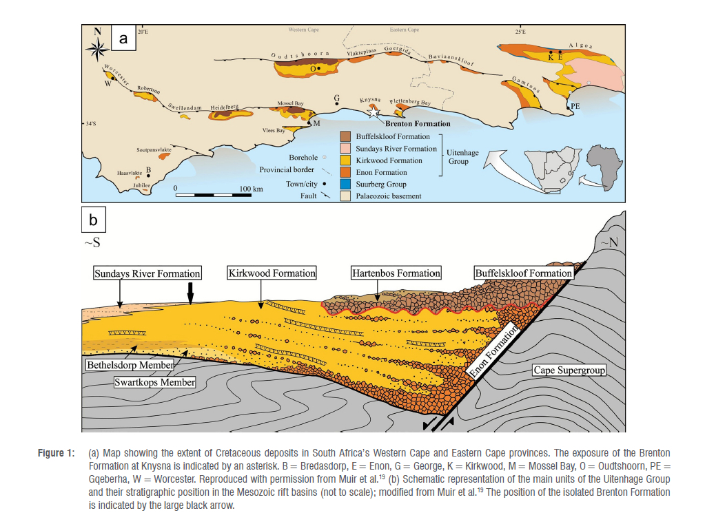
A tiny pocket of Cretaceous Brenton Formation deposits is exposed along the shore of the Knysna Estuary (Figure 1). It has yielded a theropod tooth and probably a portion of an ornithischian tibia - the latter, found on a beach at Brenton-on-Sea, may have originated in an offshore exposure of the Brenton Formation.33 Along with the examples mentioned above, these constitute the only known published records of vertebrate Mesozoic body fossils from the Western Cape Province.
The purpose of this paper is to report on the Mesozoic tracks that have been identified within the sub-aerial exposure of the Brenton Formation. Resulting implications of this discovery are then addressed. Many of the described track features are indistinct, compared to high-quality sites from southern Africa and around the world. Furthermore, the described surface exposure of the Brenton Formation is limited in size. Consequently, track assignment to ichnotaxon or ichnofamily is often not feasible. The intent of this paper is to acknowledge these limitations, but nonetheless to document what are probably the youngest dinosaur tracks reported to date from southern Africa, and the second reported site of Cretaceous dinosaur tracks in southern Africa.
Geological context
The break-up of Gondwana, involving rifting between Africa and South America, occurred between the Early Jurassic and the Early Cretaceous.18 As a result, the Outeniqua Basin accumulated sediment as much as several kilometres in thickness.34,35 Sedimentary rocks in the northern portion of this basin are patchily exposed along the Cape south coast of South Africa and inland.
The precise stratigraphic relationships of the Brenton Formation within the Uitenhage Group remain uncertain, as does its age. Whereas the lower terrestrial part of the Brenton Formation is thought to correlate with the Kirkwood Formation, the upper marine part is thought to correlate with the Sundays River Formation.36,37 The age of the Formation has been interpreted as Late Jurassic, based on ostracod assemblages and an ammonite38, or Early Cretaceous (Late Valanginian or Hauterivian), based on foraminiferal assemblages37. While the former of these contentions has been refuted either on grounds of misidentification or of reworking of sediments37, this is not unequivocal. Nonetheless, recent opinion tends towards a Valanginian or Hauterivian age.39 An attempt to resolve the age of the Brenton Formation using detrital zircon geochronology was unsuccessful, due to an absence of Cretaceous zircons.39
The Brenton Formation only outcrops in the Knysna area, and comprises greenish-grey and beige sandstones and mudstones, claystones and siltstones, with a thickness of 6-20 m, as well as occasional conglomerates.39 It is exposed along the southern margin of the Knysna Estuary at low tide.38-40 The mudstones are exposed either as relatively level surfaces or as grey-weathering cliffs. The sandstone outcrops may be massive or exhibit cross bedding and may occasionally contain well-rounded quartzite pebbles and charcoal fragments. The sandstone beds are more likely to form cliff exposures than the mudstone units.
Methods
Standard track measurements of length, width and depth were recorded in centimetres, along with (where appropriate) pace length, possible stride length and interdigital angles (measured in degrees). For tracks evident in profile, their diameter and the depth of deformation were measured. Photographs were taken during different lighting conditions. Following initial photographing, tracks were outlined lightly in chalk and further photographs were taken.
Photographs were taken for photogrammetric analysis41,42, from which 3D models were generated with Agisoft Metashape Professional (v. 1.0.4) using an Olympus Tough model TG-6 camera (focal length 4.5 mm; resolution 4000 x 3000; pixel size 1.56 x 1.56 μm). The final images were rendered using CloudCompare (v.2.10-beta). The photographs used for generating the three photogrammetry models, and the associated bin files, are available at https://data.mendeley.com/datasets/st8vrbmjt6/1.
A transect of overlapping photographs of the cliff face was taken from southeast to northwest, to document the extent of the cliff outcrop. Drone photography was employed, using a DJI Air 3 model, with a 16:9 ratio.
Strike and dip readings were obtained, and the stratigraphy and sedimentology of the surrounding deposits were assessed. Where accessible, bushes were clipped so as to expose the cliff outcrop. Global Positioning System readings were taken, using a handheld device. Locality data were reposited with the African Centre for Coastal Palaeoscience at Nelson Mandela University and are available to researchers upon request.
Results and interpretation
Cliffs of the Brenton Formation, approximately 5 m in height, crop out on the southwestern shore of the Knysna Estuary, and extend for 40 m in a southeast to northwest direction (Figure 2). A short drone video documents the site: https://data.mendeley.com/datasets/st8vrbmjt6/1. The tracklike features were first noted by Linda Helm.
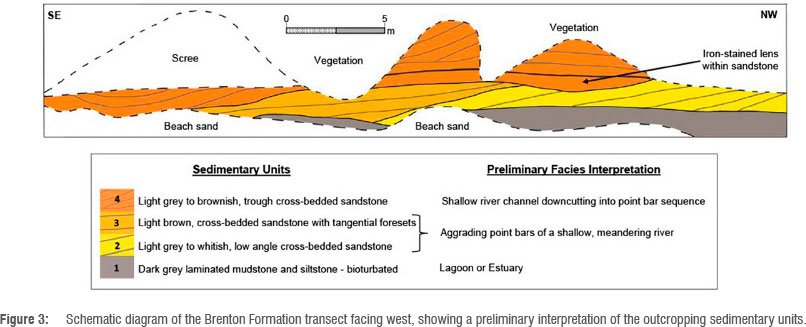
A schematic, cross-sectional diagram based on the transect of the outcrop exposed in the cliff is illustrated in Figure 3. Due to the limited extent of the outcrop, it was not possible to conduct a definitive interpretation of the sedimentary palaeoenvironment in which these Brenton Formation rocks were deposited. However, the presence of indicative bedform structures enables certain deductions to be made.
The lowermost unit consists of bioturbated (probably 'dinoturbated'), dark-grey laminated mudstone and siltstone ('Unit 1'), which is heavily jointed (joints are typically fairly regularly spaced, 2-3 cm apart). The base of the mudstone/siltstone layer extends as a series of palaeosurfaces towards the estuary, with a 1° dip to the northeast, and is inundated twice daily during high-tide events. These palaeosurface outcrops, which measure a total of 10 m χ 5 m, are partially or completely covered by estuarine sand, mud, pebbles or loose rocks after periodic sedimentary inundation. Unit 1 contains most of the tracks described here.
Unit 1 is overlain by a light grey to whitish sandstone ('Unit 2') that displays low-angle cross-bedded foresets inclined to the southeast. The contact between these two units is vague, being possibly transitional. Unit 2 is overlain by a light brown channelised sandstone lens (Unit 3) which, in places, appears to be downcutting into Unit 2. (No tracks or track-like features were noted in Unit 2.) It, in turn, is overlain by a channelised sandstone (Unit 4), which also displays cross-bedding and contains Liesegang ring features. The sequence is overlain by modern calcrete and scree. Given the dip of the strata to the southeast, moving from southeast to northwest along the base of the cliffs involves travelling 'down-section'. Unit 1 is consequently not visible in the southeastern portion.
This 'pocket' of Brenton Formation outcrop probably represents a basinward facies extension of the channelised conglomerates exposed along the lagoon cliff faces further north and west at Belvidere and Knysna. Within the Knysna Cretaceous Basin, there is a rapid southward decrease in clast size within the fluvial channels, resulting in few to no pebbles in the sandstone south of Belvidere. The sequence in the cliff-face outcrop described here is considered to represent shallow water, sandy fluvial channel and point bar sediments (Units 2, 3 and 4) deposited in a lagoonal environmental setting. Unit 1, containing most of the tracks, probably represents a lagoonal mudstone environment.
The features which are interpreted here as dinosaur tracks (or possible tracks) are evident in plan view and in profile. The plan view features are described first, followed by the profile features. Because of the limited amount of outcrop, almost all the features that are suggestive of tracks are described.
Features in 'plan view'
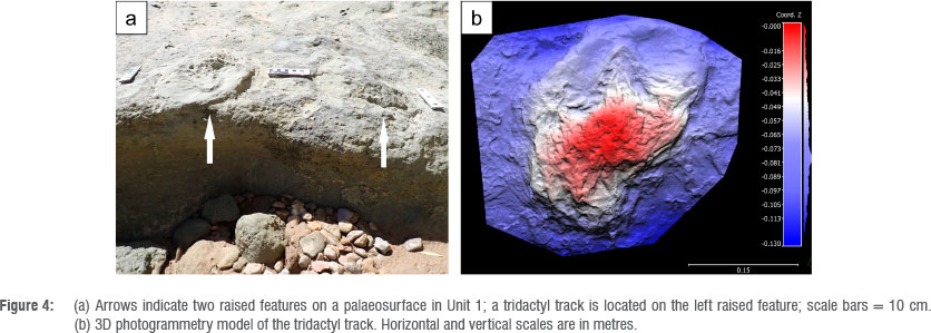
The features within the intertidal area on the palaeosurfaces in Unit 1 are described from southeast to northwest. Several occur on a palaeosurface in the southeastern portion of the unit, which lies about 15 cm above the level of the northwestern palaeosurface. Two features, ~40 cm apart, are raised above the surface (Figure 4a). The southeastern feature appears amorphous, whereas a small, asymmetrical tridactyl track, with maximum length of 21 cm and maximum width of 21 cm, is evident on the northwestern feature (Figure 4b).
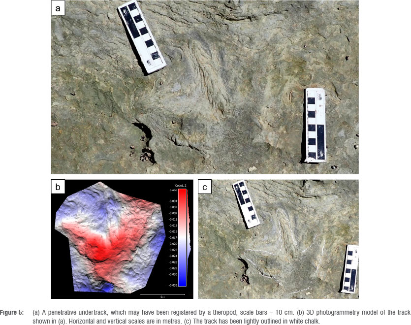
A further track, with relatively long, narrow digits, is also slightly raised above the surface (Figure 5). Maximum length is 19 cm, and maximum width is 17 cm. The digits display no curvature, and the feature is interpreted as a penetrative undertrack, in which the longitudinal striations evident in digit III represent the broken edges of underlying layers that were bent down by the descending foot.43,44 The digit III trace is clearly visible in Figures 5a and 5c, but is not prominent in the photogrammetry image (Figure 5b) as it exhibits little relief. The track morphology is thus best appreciated by examining all the images in Figure 5. While this track exhibits features that suggest that it was registered by a ther opod (e.g. long, narrow, straight digits; track length slightly greater than track width), this is a tentative conclusion, as the mode of preservation could contribute to such apparent attributes.
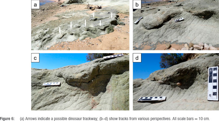
At the northwestern edge of this palaeosurface, at least five further raised areas are present in a curvilinear pattern in pedestalled epirelief (Figure 6). Some of these are also evident in profile view. They are amorphous, but consistently about 30 cm in size. Where deformation of underlying layers is visible, it is as much as 10 cm deep. Although trackmaker identity cannot be identified, the curvilinear pattern suggests a possible trackway with a mean pace length of 38 cm.
The northwestern palaeosurface lies lower than the southeastern section. On it there is a raised feature, which exhibits a maximum length of 40 cm, a maximum width of 42 cm, and a tridactyl pattern with blunt-tipped digits (Figure 7a). It is interpreted as a probable low-fidelity dinosaur track preserved in pedestalled epirelief.
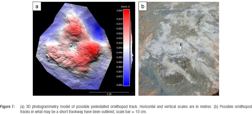
Nearby are two raised features, 30 cm long and 34 cm wide, with a pace length of 60 cm (Figure 7b). Both exhibit tridactyl morphology with blunt-tipped digits. They may represent a short segment of a pedestalled ornithopod trackway, but the low-fidelity morphology does not permit any confident conclusion.
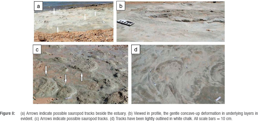
In the same area, at least six large, saucer-shaped depressions are raised as much as 3 cm from the surface (Figure 8). These measure up to 60 cm in diameter, and in two cases appear in pairs comprising a large round or oval feature adjacent to a smaller one. Where these features can be viewed in profile, slight concave deformation of underlying layers is apparent. Evidence of digit outlines is absent. These features are interpreted as possible sauropod tracks preserved in pedestalled epirelief, although other explanations need to be considered.
Features in profile
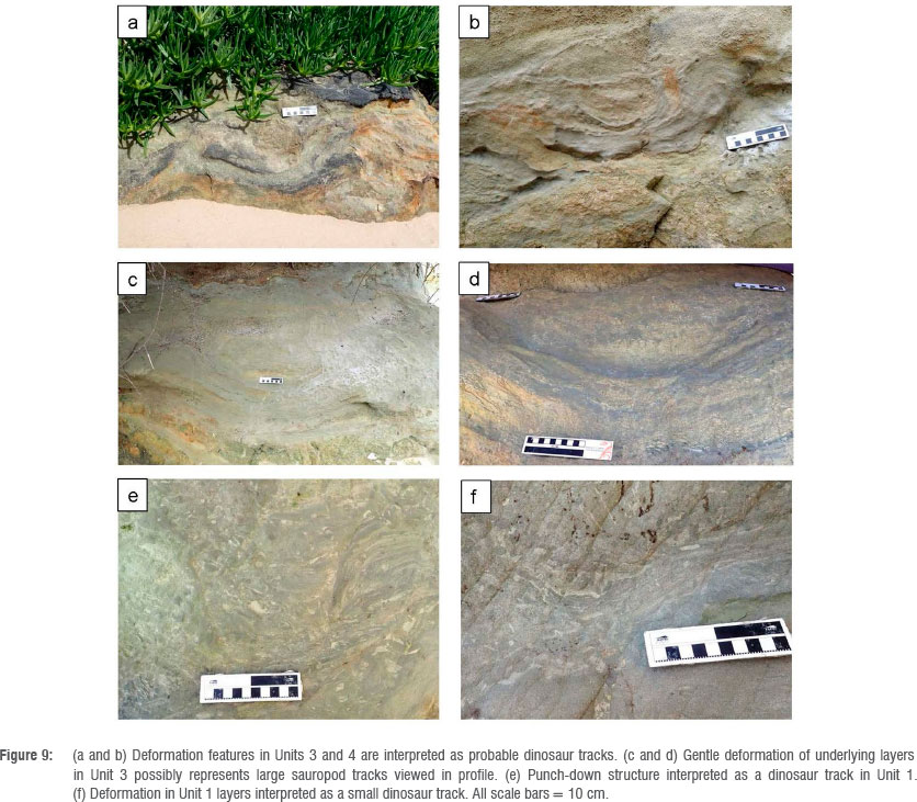
Tracklike features are described from southeast to northwest. At the southeastern end of the cliffs, a concave-up deformation (as much 20 cm deep and 40 cm in diameter) is present in Unit 4 just above beach level (Figure 9a). Moving northwest, an area of concave-up deformation, 15 cm deep and 36 cm in maximum diameter, is evident in Unit 3, about 70 cm above beach level. A smaller area of concave deformation, 14 cm in diameter, is present in the upper portion of the area of deformation (Figure 9b). In general, lower layers within this feature are progressively less deformed. As discussed in greater detail below, these features, which are evident here in profile, are consistent with dinosaur tracks, although the trackmaker cannot be identified.
Vegetation that was hanging down over the cliffs was cleared, to fully expose two large areas of gentle concave-up deformation, with a diameter of 70 cm and depth of as much as 30 cm, in Unit 3 (Figures 9c and 9d). This finding raises the possibility of sauropod tracks, registered in a relatively firm sandy substrate, now evident in profile, although a confident conclusion is not tenable.
The cliffs then briefly angle in a westerly direction before continuing in a northwesterly direction. Just around this corner, a punch-down structure is evident in Unit 1, with substantial deformation that includes microfaulting (Figure 9e). The feature is 14 cm in maximum diameter and depth, and is indicative of a dinosaur track, probably registered in a soft substrate, and now evident in profile.
The next feature, also in Unit 1, is smaller - 10 cm in diameter and 5 cm in depth (Figure 9f). Again, concave-up deformation is present, and a small dinosaur track in profile is inferred.
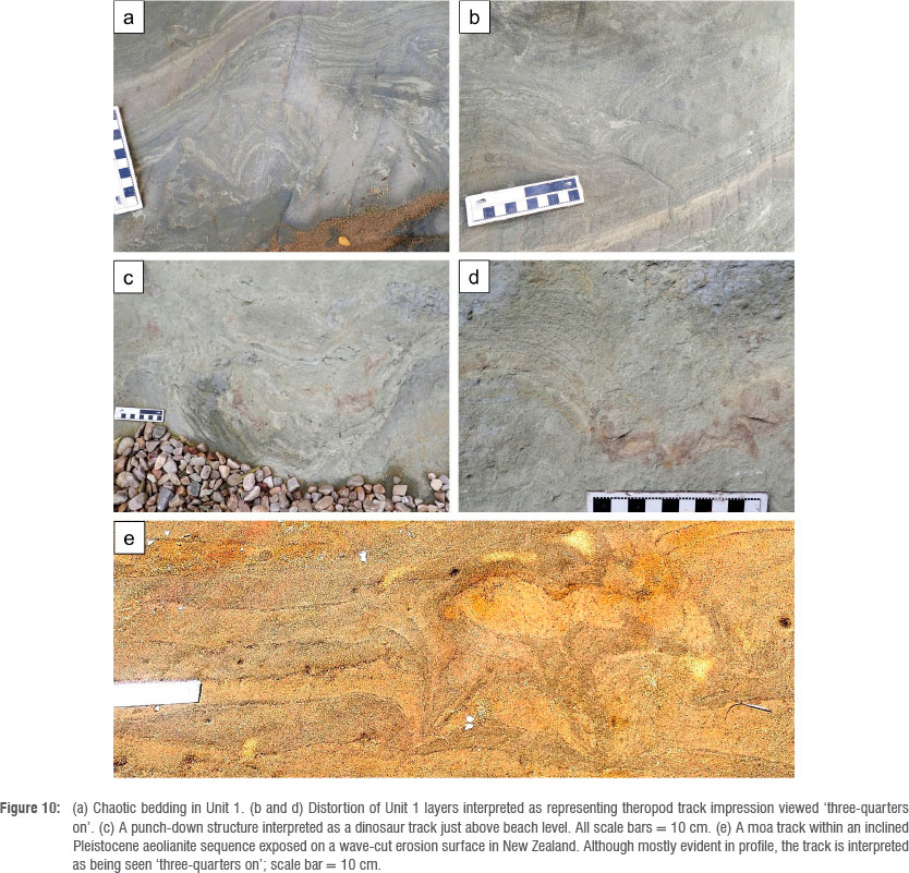
This feature is followed by an area of chaotic bedding in Unit 1 (Figure 10a). A possible explanation of this type of deformation in otherwise laminated mudstone is intense dinoturbation.
This, in turn, is followed by an intriguing feature in Unit 1. An area of concave-up deformation, 18 cm in diameter and 8 cm in depth, has two very narrow, sub-parallel projections at its northwestern end(Figure 10b). Each is ~8 cm long, and they are separated by ~4 cm. In one case, fine deformation of underlying layers is apparent. This is inferred to be a probable theropod track, viewed 'three-quarters on', with the narrow projections having been registered by two of the digits.
Next is a punch-down structure in Unit 1 of abrupt, concave-up deformation, 45 cm in diameter and 25 cm deep (Figure 10c). It is located at the base of the cliffs, just above the high-tide mark, and is interpreted as a dinosaur track in profile.
Finally, an area in Unit 1 of concave-up deformation, 10 cm in diameter and 4 cm deep, contains three narrow, tapering, sub-parallel protrusions from its lower border (Figure 10d). Fine microfaulting is present. These resemble the protrusions in Figures 10b and 10d and are also inferred to represent theropod digit impressions.
Discussion
It appears that the tracks that are evident in plan view in the limited exposure that characterises the Brenton Formation do not rise above a score of (at the most) 2 on the four-point (0-1-2-3) scale that has been developed to quantify the quality of track preservation.45 Nonetheless, the Brenton Formation contains terrestrial Mesozoic deposits which have already yielded at least one dinosaur bone. It is therefore not surprising that dinosaur tracks are preserved in these deposits, where suitable substrates and preservation factors were present. It is acknowledged that while the term 'dinosaur track' is used to describe many of the features seen in profile, other heavy trackmakers such as crocodylians might also have registered some of the traces.
The trackmaker assemblage is inferred to include theropods, possibly ornithopods and possibly sauropods. Although the distinction between theropod tracks and ornithopod tracks is not always clear46, well-preserved tridactyl tracks that are wider than they are long can reasonably be inferred to have been registered by ornithopods or similar trackmakers. The degree of asymmetry evident in Figure 4b, for example, is intriguing, but does not help to distinguish between theropod and ornithopod trackmakers in this low-fidelity track, while long, narrow, tapering digits are more characteristic of theropod tracks.47 Adopting a cautious approach, we do not feel confident in ascribing any of the described features to ornithopod trackmakers with certainty, even though there is some evidence to suggest their presence.48 Likewise, sauropod pes tracks are generally identifiable by their substantial size, round or oval shape and, sometimes, the presence of digit impressions. Although some of the features suggest a sauropod trackmaker, as discussed further below, the standard of evidence is not sufficient to make a confident assertion.
Figures 10b and 10d portray features interpreted to represent theropod tracks with digit impressions, seen 'three-quarters on'. It is instructive to compare this with a Pleistocene moa track from New Zealand, registered in sand and now preserved as aeolianite. A moa track is similar in many respects to a theropod track, in that both are tridactyl with straight, relatively narrow digit impressions.49 Figure 10e shows such a track, also viewed 'three-quarters on'. The similarity in observed morphology supports the contention that the features evident in Figures 10b and 10d indeed represent theropod digit impressions.
Many of the features interpreted here as tracks are evident in profile. We follow the foundational work on track forms performed by Allen50,51, and, for a more recent regional example, we follow Plint et al.31 The features are a type of soft-sediment deformation structure52, and other causes of such structures need to be considered and excluded. Using the rationale elucidated in Plint et al.31, we consider other causes of soft sediment deformation less plausible than the passage of heavy trackmakers, i.e. we infer a biogenic origin. For example, there is no obvious evidence to support seismic activity or gravitational load structures as a cause of the described features.
In describing features seen in profile, we note how the degree of deformation of underlying layers is related to substrate competence and may be viewed on a spectrum. At one end of this spectrum are possible sauropod tracks registered in a firm substrate (Figures 9c, 9d): only slight deformation of underlying layers is apparent, despite the inferred heavy trackmaker mass. At the other end of the spectrum is the type of deformation evident in Figure 9e, where a deep, punch-down structure with microfaulting is seen, reflecting the passage of a heavy trackmaker on a soft, muddy substrate that nonetheless had some cohesiveness. In between, on this spectrum, there exists a range of deformation features as described.
With regard to possible sauropod tracks, both the features evident in plan view (Figure 8) and in profile (Figure 9c, 9d) are of appropriate size and, in the case of Figure 8, appropriate outline and of a slightly pedestalled mode of preservation that is similar to other nearby tracks. However, it is acknowledged that the features shown in Figure 8 might also simply be weathering features, and that Figures 9c and 9d do not display the distinctive features of tracks in profile (e.g. deep, punch-down structures with microfaulting). Therefore, although the evidence for the presence of sauropod tracks can be considered suggestive, it is inconclusive.
Many of the tracks that are evident in plan view are preserved in pedestalled epirelief. Pedestalled tracks are relatively rare in the global ichnological record but are readily explained. Underlying layers are compressed and thus become resistant to erosion and deflation. Sometimes the original track is still visible, and at other times transmitted tracks (undertracks) are visible.47,53
The features identified here form the second example of Cretaceous tracks in southern Africa, and the second example of dinosaur tracks in the Western Cape. The first example involved dinosaur tracks of Berriasian age from the Robberg Formation.31 As the Brenton Formation is thought to probably be of younger age (Valanginian or Hauterivian), with an age estimate of -132 Ma, the dinosaur tracks described here therefore appear to be the youngest thus far described from southern Africa.
Conclusions
The described tracks are often subtle in appearance, and often not of exceptional preservation quality or anatomical fidelity. Due to the limited surface exposure, they will probably not meet the public expectation of obvious, long dinosaur trackways. Nonetheless, they can be readily appreciated by a discerning observer, and their major importance lies in demonstrating the presence of dinosaur tracks from the Cretaceous in the Western Cape. Our intention has not been to present impeccable examples of dinosaur tracks, but rather to emphasise that these are in all probability the youngest dinosaur tracks thus far identified in southern Africa, and the second occurrence in the Western Cape. Such distinctions give them particular significance.
In addition, pedestalled tracks are a relatively rare ichnological phenomenon, and their prevalence here is of note. Furthermore, the intriguing appearance of probable theropod tracks in 'three-quarter view' forms an unusual and noteworthy presentation. The fact that a fairly substantial number of tracks, evident both in plan view and in profile, have been identified within a relatively small area of outcrop suggests a considerable dinosaur presence in the regional shallow-water channels and point bar sediments of a lagoonal environment.
Dinosaur tracks have now been reported from the Robberg Formation and the Brenton Formation, both of which have comparatively limited exposures. Terrestrial deposits of the fossiliferous Kirkwood Formation are exposed over a much larger area in the region. A search for dinosaur tracks in suitable terrestrial exposures in this Cretaceous formation in the Western Cape and Eastern Cape provinces is indicated.
Acknowledgements
We thank Guy Plint for his general mentorship and inspiration, Linda Helm for her perspicacity and track-finding skills, Monique Van Tonder for assistance with graphics, and Guy Thesen for his help, including obtaining images for photogrammetry. Special appreciation is due to Robert Muir for providing useful and relevant information and support and giving permission to use previously published figures. We thank the three anonymous reviewers whose thorough and helpful suggestions contributed to a substantially improved manuscript.
Data availability
The data supporting the results of this study are available upon request to the corresponding author.
Declarations
We have no competing interests to declare. We have no AI or LLM use to declare.
Authors' contributions
C.W.H.: Lead author, conceptualisation, formal analysis, investigation, writing - original draft, project administration. M.G.D.: Conceptualisation, formal analysis, investigation, writing - review and editing. W.M.S.: Conceptualisation, formal analysis, writing - review and editing. F.v.B.: Conceptualisation, formal analysis, investigation, writing - review and editing. All authors read and approved the final manuscript.
References
1. Ellenberger R The fossil-bearing strata associated with the earliest appearance of mammals in South Africa and their ichnology: Establishment of detailed stratigraphic zones in the Stormberg of Lesotho (South Africa) (Upper Triassic to Jurassic). In: Haughton SH, editor. I.U.G.S. 2nd Symposium on Gondwana Stratigraphy and Palaeontology. Pretoria: Council for Scientific and Industrial Research; 1970. p. 343-370. [ Links ]
2. Ellenberger R Contribution to the classification of Triassic vertebrate trackways: Types found in the Stormberg Series of South Africa (I). Montpellier: Raleovertebrata, Memoire Extraordinaire; 1972. p. 152. [ Links ]
3. Ellenberger R. Les proto-aviens du Stormberg (Trias Sud-Africain), et leurs pistes [The proto-avians of Stormberg (South African Triassic), and their tracks]. Reun Annu Sci Terre. 1974;2:160. French. [ Links ]
4. Olsen RE, Galton RM. A review of the reptile and amphibian assemblages of the Stormberg of southern Africa, with special emphasis on the footprints and the age of the Stormberg. Ralaeontol Afr. 1984;25:87-110. [ Links ]
5. Raath MA, Kitching JW, Shone RW, Rossouw GJ. Dinosaur tracks in Triassic Molteno sediments: The earliest evidence of dinosaurs in South Africa? Ralaeontol Afr. 1990;27:89-95. [ Links ]
6. Ambrose D. A note on fossil trackways at Roma, Lesotho. Lesotho Miscellaneous Documents No. 4. Roma, Lesotho: House 9 Rublications; 2003. [ Links ]
7. Smith RMH, Marsicano CA, Wilson JA. Sedimentology and paleoecology of a diverse Early Jurassic tetrapod tracksite in Lesotho, southern Africa. Ralaios. 2009;24:672-684. https://doi.org/10.2110/palo.2008.p08-115r [ Links ]
8. Wilson JA, Marsicano CA, Smith RMH. Dynamic locomotor capabilities revealed by early dinosaur trackmakers from southern Africa. PLoS ONE. 2009;4(10), e7331. https://doi.org/10.1371/journal.pone.0007331 [ Links ]
9. Marsicano CA, Wilson JA, Smith RMH. A temnospondyl trackway from the Early Mesozoic of western Gondwana and its implications for basal tetrapod locomotion. PLoS ONE. 2014;9(8), e103255. https://doi.org/10.1371/journal.pone.0103255 [ Links ]
10. Sciscio L, Bordy EM, Abrahams M, Knoll F, McRhee BW. The first mega-theropod tracks from the Lower Jurassic upper Elliot Formation, Karoo Basin, Lesotho. PLoS ONE. 2017;12(10), e0185941. https://doi.org/10.1371/journal.pone.0185941 [ Links ]
11. Abrahams M, Bordy EM. The oldest fossil bird-like footprints from the upper Triassic of southern Africa. PLoS ONE. 2023;18(11), e0293021. https://doi.org/10.1371/journal.pone.0293021 [ Links ]
12. Abrahams M, Rampersadh A, Mpangala L. Riches of the Roma valley: Theropod and ornithischian tracks from the Early Jurassic southern Africa. Hist Biol. 2023;36(8):1612-1624. https://doi.org/10.1080/08912963.2023.2221306 [ Links ]
13. Bordy EM. Darting towards storm shelter: A minute dinosaur trackway from southern Africa. S Afr J Sci. 2021;117(5/6), Art. #9145. http://dx.doi.org/10.17159/sajs.2021/9145 [ Links ]
14. Schneider G, Marais C. Rassage through time - the fossils of Namibia. Windhoek: Gamsberg MacMillan; 2005. [ Links ]
15. Raath MA. First record of dinosaur footprints from Rhodesia. Arnoldia (Rhod.). 1972;5(27):1-5. [ Links ]
16. McCarthy T, Rubidge B. The story of earth and life - a southern African perspective on a 4.6-billion-year journey. Cape Town: Struik Rublishers; 2005. [ Links ]
17. Bordy EM, Rampersadh A, Abrahams M, Lockley MG, Head HV. Tracking the Rliensbachian-Toarcian Karoo firewalkers: Trackways of quadruped and biped dinosaurs and mammaliaforms. PLoS ONE. 2020;15(1), e0226847. https://doi.org/10.1371/journal.pone.0226847 [ Links ]
18. Muir RA, Bordy EM, Mundil R, Frei D. Recalibrating the breakup history of SW Gondwana: U-Rb radioisotope age constraints from the southern Cape of South Africa. Gondwana Res. 2020;84:177-193. https://doi.org/10.1016/j.gr.2020.02.011 [ Links ]
19. Muir RA, Bordy EM, Reddering JSV, Viljoen JHA. Lithostratigraphy of the Kirkwood Formation (Uitenhage Group), including the Bethelsdorp, Colchester and Swartkops members, South Africa. S Afr J Geol. 2017;120(2):281-293. https://doi.org/10.25131/gssajg.120.2.281 [ Links ]
20. Rich T, Molnar RE, Vickers Rich R. Fossil vertebrates from the Late Jurassic or Early Cretaceous Kirkwood Formation, Algoa Basin, southern Africa. Trans Geol Soc S Afr. 1983;86:281-291. [ Links ]
21. De Klerk WJ. South Africa's first dinosaur revisited - history of the discovery of the stegosaur Paranthodon africanus (Broom). Ann East Cape Mus. 2000;1:54-60. [ Links ]
22. McRhee BW, Mannion RD, De Klerk WJ, Choiniere JN. High diversity in the sauropod dinosaur fauna of the Lower Cretaceous Kirkwood Formation of South Africa: Implications for the Jurassic-Cretaceous transition. Cret Res. 2016;59:228-248. https://doi.org/10.1016/j.cretres.2015.11.006 [ Links ]
23. De Klerk WJ, Forster CA, Sampson SD, Chinsamy-Turan A, Ross CF. A new coelurosaurian dinosaur from the Early Cretaceous of South Africa. J Vertebr Raleontol. 2000;20(2):324-332. https://doi.org/10.1671/0272-4634(2000)020[0324:ANCDFT]2.0.CO;2 [ Links ]
24. Choiniere JN, Forster CA, De Klerk WJ. New information on Nqwebasaurus thwazi, a coelurosaurian theropod from the Early Cretaceous Kirkwood Formation in South Africa. J Afr Earth Sci. 2012;71-72:1-17. https://doi.org/10.1016/j.jafrearsci.2012.05.005 [ Links ]
25. Forster CA, De Klerk WJ, Roole KE, Chinsamy-Turan A, Roberts E, Ross CF. lyuku raathi, a new iguanodontian dinosaur from the Early Cretaceous Kirkwood Formation, South Africa. Anat Rec. 2023;306(7):1762-1803. https://doi.org/10.1002/ar.25038 [ Links ]
26. De Klerk WJ. A review of the occurrence of disarticulated Early Cretaceous sauropod dinosaur fossils from the Kirkwood Formation of the Oudtshoorn and Algoa Basins. In: Programme and abstracts: 15th Biennial Conference of the Ralaeontological Society of South Africa; 2008 September 12-14; Matjiesfontein, South Africa. p. 90-91. [ Links ]
27. Du Toit AL. The geology of South Africa. Edinburgh: Oliver and Boyd; 1954. [ Links ]
28. Hoffman AC. A gigantic plesiosaur from the South African Cretaceous. S Afr J Sci. 1966;62(5):138-140. [ Links ]
29. Almond JE. Rroposed Sondereind Wind Energy Farm near Vleesbaai, Mossel Bay Magisterial District, Western Cape Rrovince. Ralaeontological impact assessment: Combined desktop & scoping study. Cape Town: Natura Viva; 2012. [ Links ]
30. Newton AR, Shone RW, Booth RWK. The Cape Fold Belt. In: Johnson MR, Annhauser CR, Thomas RJ, editors. The geology of South Africa. Johannesburg: Geological Society of South Africa / Council for Geoscience; 2006. p. 521-531. [ Links ]
31. Rlint AG, Helm CW, Van Berkel F, Dixon MG. Soft-sediment deformation structures in the Lower Cretaceous Robberg Formation, South Africa: Distinguishing the effects of dinosaurs and earthquakes in an estuarine, rift basin setting. Ichnos. 2025;32(2):116-160. https://doi.org/10.1080/10420940.2025.2463341 [ Links ]
32. Reddering JSV. Sedimentary facies, sequences and depositional environments of the Mesozoic Robberg Formation in its type area, South Africa. Counc Geosci Bull. 2000;126:212. [ Links ]
33. Helm C, Cawthra H, De Vynck J, Dixon M, Stear W, Thesen G, et al. Tracks cast in stone. In: Whitfield AK, Breen CM, Read M, editors. Knysna estuary: Jewel of the Garden Route. Cape Town: Knysna Basin Rroject, Hansa Digital & Litho Rrinters; 2023. p. 43-73. [ Links ]
34. McMillan IK. Foraminiferally defined biostratigraphic episodes and sedimentation pattern of the Cretaceous drift succession (Early Barremian to Late Maastrichtian) in seven basins on the South African and southern Namibian continental margin. S Afr J Sci. 2003;99:537-576. https://hdl.handle.net/10520/EJC97566 [ Links ]
35. McMillan IK, Brink GJ, Broad DS, Maier JJ. Late Mesozoic sedimentary basins off the south coast of South Africa. In: Selley RC, editor. Sedimentary basins of the world volume 3: African basins. Amsterdam: Elsevier; 1997. p. 319-376. https://doi.org/10.1016/S1874-5997(97)80016-0 [ Links ]
36. McLachlan IR, McMillan IK. Review and stratigraphic significance of Southern Cape Mesozoic palaeontology. Trans Geol Soc S Afr. 1976;79:197-212. [ Links ]
37. McLachlan IR, Brenner RW, McMillan IK. The stratigraphy and micropalae- ontology of the Cretaceous Brenton Formation and the RB-A/1 well, near Knysna, Cape Rrovince. Trans Geol Soc S Afr. 1976;79:341-370. [ Links ]
38. Dingle RV Klinger HC. Significance of Upper Jurassic sediments in the Knysna outlier (Cape Province) for timing of the breakup of Gondwanaland. Nat Phys Sci. 1971;232(28):37. https://doi.org/10.1038/physci232037a0 [ Links ]
39. Muir RA. Recalibrating the breakup history of SW Gondwana: The first U-Pb chronostratigraphy for the Uitenhage Group, South Africa [PhD thesis]. Cape Town: University of Cape Town; 2018. [ Links ]
40. Rigassi DA, Dixon GE. Cretaceous of the Cape Province, Republic of South Africa. In: Dessauvagie TFJ, Whiteman AJ, editors. African geology. Ibadan: University of Ibadan; 1972. p. 513-527. [ Links ]
41. Matthews NA, Noble TA, Breithaupt BH. Close-range photogrammetry for 3-D ichnology: The basics of photogrammetric ichnology. In: Falkingham PL, Marty D, Richter A, editors. Dinosaur tracks: The next steps. Bloomington, IN: Indiana University Press; 2016. p. 28-55. [ Links ]
42. Falkingham PL, Bates KT, Avanzini M, Bennett M, Bordy EM, Breithaupt BH, et al. A standard protocol for documenting modern and fossil ichnological data. Palaeontology. 2018;61(4):469-480. https://doi.org/10.1111/pala.12373 [ Links ]
43. Gatesy SM, Falkingham PL. Hitchcock's Leptodactyli, penetrative tracks, and dinosaur footprint diversity. J Vertebr Paleontol. 2020;40(3):1-18. https://doi.org/10.1080/02724634.2020.1781142 [ Links ]
44. Lallensack JN, Leonardi L, Falkingham PL. Glossary of fossil tetrapod tracks. Palaeontol Electr. 2025;28(1), a8. https://doi.org/10.26879/1389 [ Links ]
45. Belvedere M, Farlow JO. A numerical scale for quantifying the quality of preservation of vertebrate tracks. In: Falkingham PL, Marty D, Richter A, editors. Dinosaur tracks: The next steps. Bloomington, IN: Indiana University Press; 2016. p. 92-99. [ Links ]
46. Castanera D, Pascual C, Razzolini NL, Vila B, Barco JL, Canudo JI. Discriminating between medium-sized tridactyl trackmakers: Tracking ornithopod tracks in the base of the Cretaceous (Berriasian, Spain). PLos ONE. 2013;8(11), e81830. https://doi.org/10.1371/journal.pone.0081830 [ Links ]
47. Lockley M. Tracking dinosaurs. Cambridge, MA: Cambridge University Press; 1991. [ Links ]
48. Marchetti L, Belvedere M, Voigt S, Klein H, Castanera D, Díaz-Martínez I, et al. Defining the morphological quality of fossil footprints. Problems and principles of preservation in tetrapod ichnology with examples from the Palaeozoic to the present. Earth-Sci Rev. 2019;193:109-145. https://doi.org/10.1016/j.earscirev.2019.04.008 [ Links ]
49. Hunt AP, Lucas SG. An overview of the ichnology of moa tracks and other traces from the Late Cenozoic of New Zealand. In: Taylor LH, Raynolds RG, Lucas SG, editors. Vertebrate paleoichnology: A tribute to Martin Lockley. Bull New Mexico Mus Nat Hist Sci. 2004;95:179-197. [ Links ]
50. Allen JRL. Sedimentary structures, their character and physical basis vol. II. Developments in sedimentology. Amsterdam: Elsevier; 1984. p. 30. [ Links ]
51. Allen JRL. Subfossil mammalian tracks (Flandrian) in the Severn Estuary, S.W. Britain: Mechanics of formation, preservation and distribution. Philos Trans R Soc Lond B Biol Sci. 1997;35(1352):481-518. https://doi.org/10.1098/rstb.1997.0035 [ Links ]
52. Owen G, Moretti M, Alfaro P. Recognising triggers for soft-sediment deformation: Current understanding and future directions. Sediment Geol. 2011;235(3-4): 133-140. https://doi.org/10.1016/j.sedgeo.2010.12.010 [ Links ]
53. Thulborn T. Impact of sauropod dinosaurs on lagoonal substrates in the Broome Sandstone (Lower Cretaceous), Western Australia. PLoS ONE. 2012;7(5), e36208. https://doi.org/10.1371/journal.pone.0036208 [ Links ]
 Correspondence:
Charles Helm
Email: helm.c.w@gmail.com
Received: 26 June 2025
Revised: 30 Oct. 2025
Accepted: 18 Nov. 2025
Published: 29 Jan. 2026
Editor: :Jemma Finch
Funding: None
