


Services on Demand
Article
 English (pdf)
 Article in xml format
 Article references
Indicators

Related links
-
 Cited by Google
 -
 Similars in Google
Share

 Permalink
Town and Regional Planning
On-line version ISSN 2415-0495
Print version ISSN 1012-280X
Town reg. plan. (Online) vol.83 Bloemfontein 2023
http://dx.doi.org/10.38140/trp.v83i.7436
REVIEW ARTICLE
Evaluating urban land-use demarcation and implementation for various urban functions using GIS and survey-based data: The case of Abuja City, Nigeria
Evaluering van stedelike grondgebruik afbakening en implementering vir verskeie stedelike funksies deur gebruik te maak van gis en opname-gebaseerde data: die geval van Abuja city, Nigerië
Tekolo ea moeli oa tsebeliso ea mobu oa litoropo le nts'etsopele bakeng sa mesebetsi e fapaneng ea litoropong ho sebelisoa gis le tlhaiso-leseling e thehiloeng lipatlisisong: boithuto ba Abuja city, Nigeria
Evidence EnoguanbhorI; Gladys ChukwurahII; Eveline EnoguanbhorIII; Chioma John-NsaIV; Matthew IsimahV; Iwebuke EdoVI; Robert AchenuiVII; Saheed MatemilolaVIII; Chefor FotangIX; Uche IjiomaX; Esther IbrahimXI
IDepartment of Geography, Humboldt University of Berlin, Germany. Email: enoguanbhor.ec@gmail.com, ORCID: https://orcid.org/0000-0003-4752-3063
IIDepartment of Urban and Regional Planning, University of Nigeria, Nsukka, Nigeria. Email: gladys.chukwurah@unn.edu.ng, ORCID: https://orcid.org/0000-0002-2356-0591; * (corresponding author)
IIIDepartment of Civil Law and Public Law, Brandenburg University of Technology, Cottbus-Senftenberg, Germany. Email: evelinemwambene@yahoo.com, ORCID: https://orcid.org/0009-0000-6550-5315
IVDepartment of Urban and Regional Planning, University of Nigeria, Nsukka, Nigeria. Email: chioma.onwuneme@unin.edu.ng, ORCID: https://orcid.org/0000-0002-0534-3091
VDepartment of Geography and Environmental Sustainability, University of Nigeria, Nsukka, Nigeria. Email: matthew.isimah@unn.edu.ng, ORCID: https://orcid.org/0000-0003-4679-5788
VIDepartment of Civil Law and Public Law, Brandenburg University of Technology, Cottbus-Senftenberg, Germany. ORCID: https://orcid.org/0000-0003-3710-0649
VIIDepartment of Civil Law and Public Law, Brandenburg University of Technology, Cottbus-Senftenberg, Germany. Email: achieniurobert@yahoo.com
VIIIThe Hanseatic Institute for Entrepreneurship and Regional Development, University of Rostock, Germany. Email: matem7_saheed@yahoo.com, ORCID: https://orcid.org/0000-0002-9183-5374
IXDepartment of Ecology, Brandenburg University of Technology, Cottbus-Senftenberg, Germany. Email: fotangchefor@gmail.com
XDepartment of Raw Material and Natural Resource Management, Brandenburg University of Technology, Cottbus-Senftenberg, Germany. Email: uchedickson.ijioma@b-tu.de, ORCID: https://orcid.org/0000-0003-3833-7402
XIDepartment of Geography, Humboldt University of Berlin, Germany. Email: esther.shupel@gmail.com, ORCID: https://orcid.org/0000-0001-8258-0931
ABSTRACT
Urban planning implementation is a crucial process of urban planning to improve, attain, and maintain urban sustainability globally. However, the implementation process for land use demarcated for various urban functions is being confronted by various challenges in the Global South. This study aims to integrate questionnaire surveys of urban and regional planning experts and Geographic Information Systems (GIS), in order to investigate the level of urban planning implementation of land use demarcated for various urban functions to support strategic actions for urban sustainability. Using Abuja, Nigeria, as a case study, an urban plan, urban impervious surface map, and questionnaire data were collected, and an integrated method analysis, including qualitative and quantitative (descriptive, Euclidean Distance Modelling, and Linear Regression Modelling) was deployed. Key findings show that the vast majority of experts in urban and regional planning perceive the implementation of all land use for various urban functions to be between moderate and very high levels, except that of industrial land use perceived to be between moderate and low levels. GIS findings show that, while land uses demarcated for transportation, commercial, educational, and institutional functions are positively and significantly associated with the urban impervious surface, industrial land use and urban green spaces are negatively associated. Findings show that abuse of official privileges by distorting master plans, political interference, compromise by public servants, and inadequate funding are key challenges for urban planning implementation on land use demarcated for various urban functions. The findings in this study are crucial for strategic decision makers in urban planning to improve the implementation process for various urban land-use functions and urban sustainability in the Global South, in general, and in sub-Saharan Africa, in particular.
Keywords: Demarcation, land-use functions, urban sustainability, urban impervious surface, urban plan, GIS, land use, sub-Saharan Africa, Global South
OPSOMMING
Die implementering van stedelike beplanning is 'n deurslaggewende proses van stedelike beplanning om stedelike volhoubaarheid wêreldwyd te verbeter, te bereik en te handhaaf. Die implementeringsproses vir grondgebruik wat vir verskeie stedelike funksies afgebaken is, word egter deur verskeie uitdagings in die Global South gekonfronteer. Hierdie studie het ten doel om vraelysopnames van stads- en streekbeplanningkundiges en Geografiese Inligtingstelsels (GIS) te integreer om die vlak van stedelike beplanningsimplementering van grondgebruik wat vir verskeie stedelike funksies afgebaken is, te ondersoek om strategiese aksies vir stedelike volhoubaarheid te ondersteun. Deur Abuja, Nigerië, as 'n gevallestudie te gebruik, is 'n stedelike plan, stedelike ondeurdringbare oppervlakkaart en vraelysdata ingesamel, en 'n geïntegreerde metode-analise, insluitend kwalitatiewe en kwantitatiewe (beskrywende, Euklidiese Afstandsmodellering en Lineêre Regressie Modellering) is ontplooi. Sleutelbevindinge toon dat die meeste deskundiges in stedelike en streekbeplanning die implementering van alle grondgebruik vir verskeie stedelike funksies as tussen matige en baie hoë vlakke beskou, behalwe dié van industriële grondgebruik wat waargeneem word as tussen matige en lae vlakke. GIS-bevindinge toon dat, terwyl grondgebruike wat vir vervoer afgebaken is, kommersiële, opvoedkundige en institusionele funksies positief en beduidend geassosieer word met die stedelike ondeurdringbare oppervlak, word industriële grondgebruik en stedelike groen ruimtes negatief geassosieer. Bevindinge toon dat misbruik van amptelike voorregte deur verdraaiing van meesterplanne, politieke inmenging en kompromie deur staatsamptenare, en onvoldoende befondsing sleuteluitdagings is vir stedelike beplanningsimplementering op grondgebruik wat vir verskeie stedelike funksies afgebaken is. Die bevindinge in hierdie studie is van kardinale belang vir strategiese besluitnemers in stedelike beplanning om die implementeringsproses vir verskeie stedelike grondgebruikfunksies en stedelike volhoubaarheid in die Globale Suide in die algemeen en in Afrika suid van die Sahara in die besonder te verbeter.
KAKARETSO
Tsebetso ea moralo oa litoropo e bohlokoahali ho ntlafatsa, ho fihlela le ho boloka botsitso ba litoropo lefatseng ka bophara. Leha ho le joalo, tsebeliso ea mobu e behiloeng bakeng sa mesebetsi e fapaneng ea litoropo e tobane le liqholotso tse fapaneng libakeng tsa Global South. Boithuto bona bo reretsoe ho kopanya lipatlisiso tsa lethathamo la lipotso tsa litsebi tsa meralo ea litoropo le libaka le Geographic Information Systems (GIS) ho batlisisa boemo ba ho kengoa tsebetsong ha moralo oa litoropo oa tsebeliso ea mobu e etselitsoeng mesebetsi e fapaneng ea litoropo ho ts'ehetsa ts'ebetso ea maano a teng o netefatsa ntsetsopele ea maphomella ea litoropo. Ho sebelisoa Abuja, Nigeria e le mohlala, ho ile ha bokelloa moralo oa toropo, 'mapa oa toropo, le lintlha tsa lethathamo la lipotso, hoa oetse hoa sebelisoa mokhoa o kopanetsoeng oa ho hlahloba, ho kenyeletsoa boleng le lipalo (e hlalosang, Euclidean Distance Modelling, le Linear Regression Modelling). Liphuputso tsa bohlokoa li bonts'itse hore litsebi tse ngata tsa moralo oa litoropo le libaka li hlokometse hore ts'ebeliso eohle ea mobu bakeng sa mesebetsi e fapaneng ea litoropo e lipakeng tsa maemo a itekanetseng le a holimo haholo, ntle le a ts'ebeliso ea mobu oa liindasteri ho nahanoang e le lipakeng tsa maemo a itekanetseng le a tlase. Liphuputso tsa GIS li bontsitse hore le hoja tsebeliso ea mobu e arotsoe bakeng sa lipalangoang, mesebetsi ea khoebo, ea thuto le ea litsi tsa tsebetso e amana hantle le sebaka sa litoropo, tsebeliso ea mobu oa indasteri le libaka tse tala tsa litoropo li amahanngoa hampe. Liphuputso li bontsitse hore tsebeliso e mpe ea litokelo tsa molao ka ho sotha merero e meholo, ho kena-kenana hoa lipolotiki le ho sekisetsoa ke basebeletsi ba sechaba, le lichelete tse sa lekaneng ke liqholotso tse ka sehloohong bakeng sa ts'ebetso e atlehileng ea moralo oa litoropo mabapi le tsebeliso ea mobu e etselitsoeng mesebetsi ka ho fapana. Liphetho tsa phuputso ena li bohlokoa bakeng sa baetsi ba liqeto tsa maano mabapi le moralo oa litoropo ho ntlafatsa ts'ebetso e fapaneng ea mobu litoropong le ts'ebeliso ea litoropo lefatse lohle ka kakaretso le ka ho khetheha Afrika e ka boroa ho Sahara.
1. INTRODUCTION
In the Global South, especially in sub-Saharan Africa, urban functions, for which the various purposes of urban spaces are demarcated (for example,residential, commercial, industrial, institutions, green spaces, and transportation), are faced with various challenges such as land-use distortions that hinder their full utilisation (Chen, et al., 2020; Guillaume, 2020). However, urban planning, which is the deliberate process of arranging spatial patterns of urban land use designated for various urban functions, helps create a functional urban environment (Enoguanbhor, 2021) and improve urban sustainability (Cobbinah, Asibey & Gyedu-Pensang, 2020). In this context, urban sustainability is a condition that allows current and future urban dwellers to maximise the cultural, social, economic, and environmental benefits provided by various urban functions without compromising urban development for current and future generations (Enoguanbhor, 2021; Cobbinah et al., 2020).
To improve, attain, and maintain urban sustainability, urban planning processes, including defining the goal and objectives, data collection and analysis, plan formulation, negotiation and decision-making, implementation, as well as monitoring and updating should be handled adequately, in order to realise the cultural, social, economic, and environmental objectives of the plan (BMZ, 2012). Implementation, which is the process of using the plan as a model to transform urban space, is crucial because it contributes to the level of actualising urban sustainability. Thus, a well-designed urban plan may not be able to provide fully the cultural, social, economic, and environmental functions of the plan if the implementation process is not handled correctly (Enoguanbhor, 2023). As a strategic action, the urban planning implementation process varies widely, but the general process includes from master plans to detailed plans, from detailed plans to permits, and from permits to developments (Long et al., 2020). Implementation in the context of this article1 focuses on, for example, the spatial patterns of urban impervious surface within land uses demarcated for various urban functions, without considering whether the type of urban elements or structures built in such demarcated locations correspond to the plan for maximum urban functions.
The implementation process can be confronted by various challenges across sub-Saharan Africa and other parts of the Global South (Admasu & Jenberu, 2020; Huang & Cantada, 2019; Negeri, Guta & Erena, 2023; Ryan & Gao, 2019). For example, in Abuja, Nigeria, illegal conversion of land use, uncontrolled and unintended development, inadequate funding, outrageous implementation cost, lack of political will, lack of coordination among government departments, inadequate consideration of the informal sector as active stakeholders, lack of formal public participation, and inadequate technical experts are challenges facing the urban planning implementation process (Enoguanbhor et al., 2023; Gumel et al., 2020; Ubani, Mba & Ugwu, 2014). Previous urban studies (Long et al., 2020; Liu et al., 2020; Admasu & Jenberu, 2020; Huang & Cantada, 2019; Negeri et al., 2023; Ryan & Gao, 2019) on urban planning implementation report low-level implementation and/or identify various challenges associated with the implementation. For example, low-level urban planning implementation was reported for Beijing, China (Long et al., 2020; Liu et al., 2020). According to Admasu and Jenberu (2020), lack of qualified personnel, lack of planning standards, and inappropriate implementation of legal frameworks are key challenges associated with low-level urban planning implementation in Arba Minch Town, Southern Ethiopia. Managing such challenges could vary among urban and regional planning experts, depending on their personal working environments and decision-making processes in strategic actions. Findings from previous studies are relevant, on the one hand, but are too general to inform strategic actions about successes and failures of urban planning implementation of individual land use demarcated for various urban functions, on the other hand. No previous study used spatial data to contrast the perceptions of urban and regional planning experts about the level of urban planning implementation on multiple urban functions for the purpose of identifying various urban land uses where the urban planning implementation process should be improved.
The current study, therefore, aims to integrate questionnaire surveys of urban and regional planning experts and Geographic Information Systems (GIS) to investigate the level of urban planning implementation of land use demarcated for various urban functions to support strategic actions for urban sustainability. Specifically, the study intends to:
1. use surveys of urban and regional planning experts to analyse the level of urban planning implementation on land use proposed for various urban functions;
2. use GIS to quantify spatial associations between the urban impervious surface and land use proposed for various urban functions for the purpose of contrasting the level of urban planning implementation based on urban and regional planning experts' perceptions and spatial data, and
3. identify key challenges for urban planning implementation of land use demarcated for various urban functions.
2. LITERATURE REVIEW
Urban planning implementation for workable land use has been the focal interest of urban and regional planners, urban geographers and GIS/remote sensing experts, environmentalists, architects, builders/civil engineers, and so on. Urban planning is the process of organising the use of land and other physical resources to improve the quality of life and general well-being of urban dwellers (Beltrao & Kessler, 2013: 1). According to Kassahun and Gobena (2022: 1), it is a technical and political process concerned with the development and use of land, protection and use of the environment, public welfare, and the design of the urban environment, including air, water, and the infrastructure passing into and out of urban areas such as transportation, communications, and distribution networks. Approximately 4.4 billion people, or 56% of the world's population, now reside in cities. By 2050, roughly 7 out of 10 people will live in cities, with the urban population predicted to be more than doubled from its current level (World Bank, 2023: 1). Human activities, urbanisation, and demographic change, predicted to be strong drivers of growth, are catalysts for the negative externalities of urban development (Li et al., 2016: 15).
The challenges of urban planning implementation of land uses for sustainable urban development are on the increase, particularly in burgeoning countries such as Nigeria and the causes have been linked to several factors. Kassahun and Gobena's (2022: 1) study on challenges of urban plan implementation in small towns of West Showa Zone, Oromia Regional State, Ethiopia, showed that poor plan implementation is associated with town establishment before plan, inadequate awareness of the importance of town plan, lack of budget, lack of skilled manpower, and environmental issues such as conflict with surrounding Kabele2 on paying compensation for land plots. According to Slaev and Nedovic-Budic (2017), Sofia's master plan in Bulgaria has large inconsistencies between the plan's overall goal and some of its measures and implementation tools. Among the various challenges, the most common were high crime levels, unemployment, health issues, poverty, pressure on public facilities/ infrastructures, high population density, as well as poor planning and implementation policies.
Aribigbola's (2007: 1) study on "Urban land-use planning, policies and management in Akure, Nigeria" revealed that, although land-use planning and policies, as well as mechanisms are in place in the city; they are not fully implemented by the State Ministry of Works, Lands, and Housing, as well as the Department of Urban and Regional Planning, and do not have any significant effect on land accessibility. As such, they advocated for the reinvigoration of land-use policies including amendment of the Land Use Act. Urban planning implementation is a critical issue in Nigeria as, according to the town planners, the continued neglect of the implementation and domestication of the law was responsible for most of the physical, environmental, social, and economic challenges afflicting the country. They pointed out that the absence of master plans and non-implementation of existing ones was a major explanation for the haphazard physical development and decay across human settlements in Nigeria (The Nigerian Tribune, 2021: 1).
3. STUDY AREA
The study area of Abuja City Development Phases I-III in the Federal Capital Territory (FCT) of Nigeria (Figure 1) was chosen due to the implementation of urban planning in the area (Enoguanbhor et al., 2022). In 1979, the International Planning Associates (IPA) prepared the urban plan (FMITI, 2015; Fola Consult Ltd., 2011) that made provisions for various urban functions across various urban development phases (Abubakar, 2014; Fola Consult Ltd., 2011; AS&P and Elsworth, 2008). The city development of Abuja is divided into five phases, which are planned to be implemented consecutively (Gumel et al., 2020). In the early 1980s, the urban planning implementation started in phase I before the government seat of power was relocated from the formal capital, Lagos to Abuja in 1991 (Adama, 2020; Sufiyan et al., 2015; Abubakar, 2014; Ejaro & Abubakar, 2013; Idoko & Bisong, 2010).
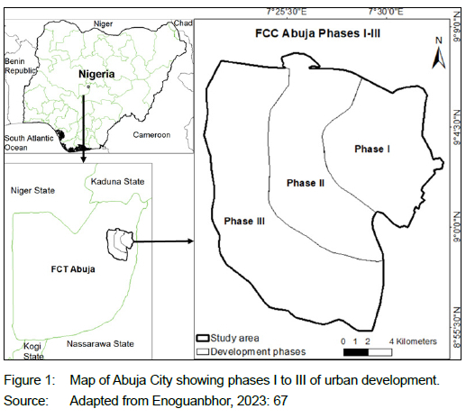
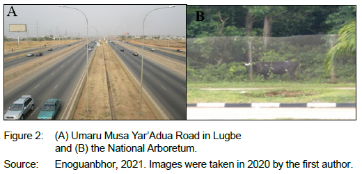
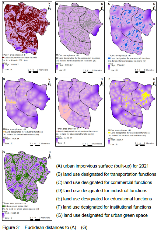
The Abuja Master Plan of 1979 was designed to guide the development of the FCT through each stage of its growth - from Phase 1, which was designed to accommodate 230,000 residents through Phases II and III, which were to accommodate 585,000 and 640,000, respectively, to Phase IV aimed at accommodating 1.7 million residents (Abubakar, 2014). The implementation has gone beyond phases I-III to IV (Gumel et al., 2020). Figure 2 shows a sample of land uses designated for transportation, which is Umaru Musa Yar'Adua Road in Lugbe that connects Phases II and III to other satellite settlements and recreation, which is the National Arboretum as an urban green space located in Phase I.
Abuja City, which is the Abuja Municipal Area Council (AMAC), and the entire FCT had a population of 776,298 and 1,406,239, respectively in 2006 (NPC, 2010: 9, 36). Over the years, the FCT, including Abuja City, has witnessed a huge influx of people into the region. Currently, FCT Abuja has a population of over 3 million and comprises the fourth largest urban area in Nigeria. Its ultimate population in 2023 is estimated at 3.8 million (Macrotrends, 2023).
4. METHODOLOGY
4.1 Research design
The study analysed the urban planning implementation of land use demarcated for various urban functions in Abuja City, Nigeria. The study employed an integrated/ mixed research approach, where the use of questionnaire surveys is combined with GIS for data collection and analysis (Creswell & Plano-Clark, 2018: 8). The reason for choosing mixed research data is to elaborate on specific findings (coefficient) from the GIS analysis, and to cross-check the data against the questionnaire data set such as similarities or differences in the level of implementing land use designated for various urban functions.
4.2 Population, sample, and response rate
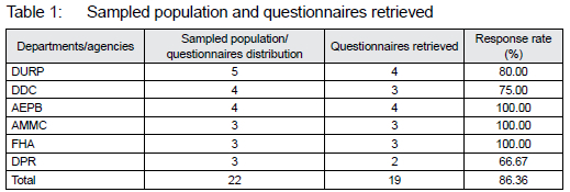
According to the Town Planners Registration Council, there were 54 registered town planner companies in Abuja in 2022 (TOPREC, 2022). To obtain the population of urban and regional planning experts in Abuja, various departments and agencies for Abuja urban management were identified, including the Department of Urban and Regional Planning (DURP), the Department of Development Control (DDC), the Abuja Environmental Protection Board (AEPB), the Department of Urban Affairs of Abuja Metropolitan Management Council (AMMC), the Federal Housing Authority (FHA), and the Department of Park and Recreation (DPR), all located in Abuja, Nigeria. Due to the need for experienced experts in urban and regional planning for information gathering, only experienced urban planners in Abuja were identified. Due to the lack of reliable data about the total population of urban and regional planning experts in the identified departments and agencies and the difficulties in identifying such experts who were willing to respond to questionnaires, the authors decided to sample 22 urban and regional planning experts (three senior staff and one junior staff member, each from the different departments and agencies) for the distribution of questionnaires; 19 questionnaires were retrieved, but 16 were valid to analyse. This shows a response rate of 86.36%, which is valid, as per built-environment survey response rates vary between 7% and 40% (Moyo & Crafford, 2010: 68, John-Nsa, 2021: 33). Considering the questionnaire data was to complement the secondary (GIS) data and authors did not plan to perform inferential statistics with the questionnaire data, analysing 16 questionnaires is valid for the current study. Table 1 presents the sampled population and questionnaires retrieved from urban and regional planning experts from various departments and agencies.
4.3 Data collection
Empirical data was collected from urban and regional planning experts through online questionnaire administration between 30 August and 22 September 2022.
The questionnaire consisted of three sections. Section A elucidated information on the respondents' profile regarding education, qualification, and work experience. Section B contained six Likert scale items presented in the form of matrix questions on urban planning implementation for urban land-use functions. Section C consisted of open-ended questions regarding the key challenges for urban planning implementation on various urban functions. Respondents were requested to rate, on a 5-point scale, how strongly these land uses as demarcated have been implemented and how strongly the challenges affect their implementation. The closed-ended questions were ideal to reduce respondents' bias (Akintoye & Main, 2007:601;John-Nsa, 2021:33).
Regarding the GIS application data, an urban land-use plan of Abuja City Phases I-III (Fola Consult Ltd., 2011) was collected from DURP, Abuja, and an Abuja city map of the observed urban impervious surface for 2021 produced by Enoguanbhor (2023) was used. Using supervised classification with maximum likelihood algorithm (Vijayalakshmi, Kumar & Arun, 2021; Campbell & Wynne, 2011; Enoguanbhor et al., 2019; Lu et al., 2011; Tso & Mather, 2009) on Landsat 8 satellite image acquired on 09/02/2021 (USGS, 2021), the user, producer, and overall accuracies of the map were estimated to be 90.2%, 87.3%, and 88.7%, respectively.
4.4 Data analysis and interpretation of the findings
While analysing the questionnaire data, a qualitative analysis (coding, sorting, synthesising, and ranking) for open-ended questions and descriptive (percentages calculations) for closed-ended and matrix questions were deployed (Babbie, 2013; Bryman, 2016; Maxwell, 2013; Secor, 2010). The percentages of responses were generated and reported, in order to describe the respondents' profile and to evaluate the level of urban planning implementation of various urban land-use functions based on urban and regional planning experts' opinions on the following scales measurements, where 1 = Very low (>1.00 and <1.99); 2 = Low (>2.00 and <2.99); 3 = Moderate (>3.00 and <3.99); 4 = High (>4.00 and <4.99), and 5 = Very high (>5.00). Likert-type scales use fixed choice response formats and are designed to measure attitudes or opinions and even perceptions (Leedy & Ormrod, 2014: 185).
The percentage calculation was performed by using a simple percentage formula: A/B * 100/1, where A is the number of respondents that identified a variable and B is the total number of respondents (sampled population). The coding, sorting, synthesising, and ranking methods were used to identify key challenges for urban planning implementation. For the interpretation of the qualitative analysis, the ranking method developed by Enoguanbhor et al. (2021) was deployed, where the number of times a variable is identified is ranked as follows: x = Very low (1-2 times), xx = Low (3-4 times); xxx = Moderate (5-6 times), and xxxx = High (7 times and more).
Spatial associations between urban impervious surface and land use demarcated for various urban functions were analysed using ArcGIS version 10.8.1 and R version 4.1.1. The analysis was performed by digitising the urban plan for various urban functions. The Euclidean distance modelling (Yenisetty & Bahadure, 2021) was used to generate parameters for all digitised variables as independent variables and the urban impervious surface as the dependent variable (Enoguanbhor, 2022). In addition, a simple and multiple linear regression modelling on all parameters (Fotang et al., 2021) was used to identify the associations between the observed urban impervious surface and urban land use proposed for various urban functions. Simple and multiple linear regression can be expressed as:
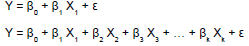
where Y is the dependent variable (the observed urban impervious surface), X is the independent variable (land use proposed for various urban functions by the urban plan), β0 is the intercept, β1 is the coefficient, and ε is the random error terms. To reduce bias in the model, the Variance Inflation Factor (VIF) was used to check multicollinearity problems, where VIF values of 5 and above are defined to identify and eliminate such problems and to ensure independent effects of independent variables on the dependent variable (Visser & Jones, 2010; Fotang et al., 2021; Enoguanbhor et al., 2022). Where the model returns a positive coefficient, it is interpreted that the urban planning implementation of land use demarcated for various urban functions is likely corresponding to the urban plan. Otherwise, the model returns a negative coefficient.
5. RESULTS AND DISCUSSION
5.1 Respondents' profile
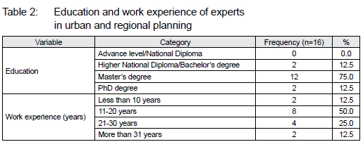
Table 2 presents the level of education and work experience of all the participating urban and regional planning experts. Regarding the level of education, the vast majority of the respondents (87.5%) had a Master's degree (75.0%) or a PhD degree (12.5%). Concerning their work experience, most of the respondents (75.5%) had between 11 and 20 years' (50.0%), and between 21 and 30 years' (25.5%) work experience. This shows that the respondents had the necessary education and work experience in urban and regional planning to make valid statements on urban land-use demarcation and implementation for various urban functions.
5.2 Urban planning implementation of land use demarcated for various urban functions
Table 3 shows the results on the level of urban planning implementation on various urban land-use functions in Abuja City, based on survey results from urban and regional planning experts. Although no land-use implementation levels were perceived as very low, the respondents showed contradicting opinions on the implementation levels of all the land-use functions.
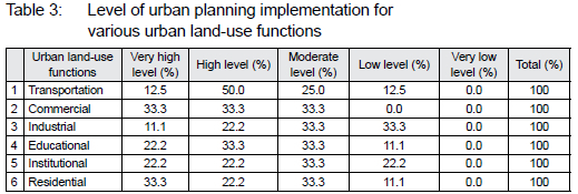
Over half of the respondents (62.5%) perceived the level of transportation land-use implementation as high (50%) to very high (12.5%) and 37.5% of the respondents perceived it as moderate (25%) to low (12.5%). Respondents rated commercial land-use implementation equally on the basis of very high, high, and moderate with 33.3% for each level. Two-thirds (66.6%) of the respondents perceived the implementation level of industrial land-use moderate (33.3%) to low (33.3%). Just over half of the respondents (55.7%) perceived the implementation level of institutional land use as moderate (33.3%) to low (22.2%) and the implementation level of educational land use as high (33.3%) to very high (22.2%). Of the respondents, 55.7% perceived the implementation levels for residential land use as very high (33.3%) to high (22.2%) and 44.4% of the respondents perceived it as moderate (33.3%) to low (11.1%).
Although the respondents perceived the urban planning implementation level for five of the land-use functions as moderate, the level for transportation, commercial, educational, and residential land-use functions were generally perceived as high. This finding differs from the findings of Long et al. (2020) and Liu et al. (2020) who reported low-level urban planning implementation for Beijing, China.
5.3 GIS-based spatial association between the urban impervious surface and land use demarcated for various urban functions
Table 4 and Figure 3 show the spatial association results and patterns between the urban impervious surface and land use designated for various urban functions by the urban plan, respectively. The level of a simple linear model generated a positive association for all land uses, except the industrial function (r=-0.012). The multiple linear models generated a negative association for land uses designated for industrial (r=-0.018) and educational (r=-0.009) functions. The low standard errors for both models, the residual standard errors for the multiple linear models, as well as the multiple and adjusted R-squares show the model's goodness of fit. The high and low values in Figure 3 indicate the Euclidean distance measurements between sampled points and variables, including urban land cover and land use demarcated for various urban functions. Although these high and low values on the maps should be read to interpret the final results in Table 4, it was not reported in Table 4 because these values were processes to generate parameters for the regression modelling and did not present the final results of the model. Table 4 presents the final results of the model.
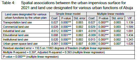
The findings (Table 4 and Figure 3) show that land uses in the urban plan proposed for transportation, commercial, educational, institutional, and urban green space functions are associated with urban impervious surfaces as expected. This indicates that the implementation of the urban plan for those urban functions, particularly within the implemented urban planned areas, corresponds with the plan with regard to urban spatial patterns. The negative association of the land use for urban green space (Table 4) with the observed urban impervious surface indicates that the green spaces are being protected from urban development to a large extent. This finding does not support the opinions of Dinda, Chatterjee and Ghosh (2021) for Kolkata, India, and of Munyati and Drummond (2020) for Mafikeng, South Africa, who reported urban green space degradation due to urban expansion. The finding is in line with Enoguanbhor et al. (2023) and Enoguanbhor (2022), who opined that urban green spaces in Abuja are protected mostly within implemented urban planned areas. In addition, the finding supports those from Liu et al. (2022) on greening policies and urban green space spatial patterns in Xuchang and Shanghai, China. However, the negative association between land use for industrial functions and the observed urban impervious surface (Table 4) indicates that the implementation does not correspond to the urban plan for industrial urban functions.
5.4 Key challenges for urban planning implementation of land use demarcated for various urban functions
Table 5 shows key challenges for urban planning implementation of land use demarcated for various urban functions based on questionnaire surveys. Key challenges perceived to highly affect planning implementation include abuse of official privileges by distorting master plans, political interference and compromise by public servants, as well as inadequate funding The challenge of "inadequate professionals" was perceived as moderate. Other challenges perceived at low levels include corruption, change in government policies, a lack of political will, and so on.
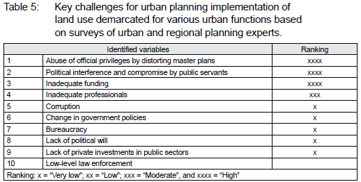
The finding on inadequate funding is consistent with those of Enoguanbhor et al. (2021). The challenge perceived as moderate is inadequate professionals and supports those of Admasu and Jenberu (2020) who reported a lack of qualified personnel as a key challenge for urban planning implementation in Arba Minch Town, Southern Ethiopia. The challenges perceived at the low level include corruption, change in government policies, bureaucracy, a lack of political will, a lack of private investments in public sectors, and low law enforcement. The findings on corruption, lack of political will, and low level of law enforcement are consistent with the findings from Enoguanbhor (2021).
5.5 Implications of the findings
The general implication of the findings can be deduced from the integrated method of GIS and urban and regional planning respondents' survey to evaluate urban planning implementation on land use demarcated for various urban functions. The contraction between GIS and the questionnaire survey shows that findings largely support each other. For example, the GIS finding on industrial land-use function, which is negatively associated with urban impervious surfaces, supports the respondents' opinions that perceived the implementation level of industrial land use as moderate to low. The GIS findings on transportation and commercial implementation level, which are positively associated with urban impervious surfaces, support respondents who perceived the implementation of transportation land use as high and commercial land use as very high to moderate. An important implication of the findings can be linked to the awareness of the implementation level of individual land use, especially considering that no previous study was conducted at this level in the study area.
Key challenges for land-use implementation (for example, abuse of official privileges by distorting master plans and political interference and compromise by public servants) may also have economic and environmental implications, especially on land uses demarcated for, for example, industrial functions, which is perceived as low-level implementation by respondents and negatively associated with the urban impervious surface as revealed by GIS. Distorting a master plan, which may be associated with conversions of land use from the original purpose to other uses, may lead to high and low economic efficiency in the short and long terms, respectively (Su & Jiang, 2021). The high economic efficiency in the short term may give rise to land-use competition, where an increase in the abilities of some human beings, as drivers of land-use dynamics to put land into use leads to a decrease in the abilities of others to put the same land into use (Niewöhner et al., 2016). Those with economic or financial capabilities may be able to compete for such distorted land uses. This may, in the long term, lead to low economic and environmental efficiencies (Su & Jiang, 2021), making it difficult to realise the economic and environmental objectives of the plan. Similarly, distorting a master plan at the implementation level of land use may have negative impacts on the cultural and social life of the current and future urban dwellers, especially if such land uses have been converted from, for example, green space to residential or commercial functions, making it difficult to actualise the sociocultural objectives of the plan. If land uses demarcated for urban green infrastructures are not distorted, besides the environmental benefits such as cooling urban heat, regulating air quality, and reducing noise pollution, such land uses provide socio-psychological benefits such as alleviation of negative emotions and relaxation to urban dwellers (Enoguanbhor, 2023).
The detailed baseline information provided in the current study is crucial for strategic decision makers in urban planning and development to improve the implementation process for urban sustainability in sub-Saharan Africa and other parts of the Global South. By combining GIS data and data from urban and regional planning experts' surveys to evaluate urban planning implementation on land use demarcated for various urban functions, this study provides detailed insights into the level of implementation on individual land use designated for urban functions. This study thus contributes to urban planning as a strategic action for improving and achieving urban sustainability.
5.6 Limitations and recommendations
The current study is limited by the low number of urban and regional planning experts identified to respond to the questionnaires. The lack of reliable data about the total population of urban and regional planning experts from various departments and agencies made it difficult to identify urban planning experts who were willing to respond to questionnaires. However, 19 out of 22 questionnaires retrieved are useful for the analysis, considering no advanced statistics were performed on the questionnaires in the current study. The study could not classify the observed urban impervious surface into different urban land uses to evaluate the gap, if any, between land use proposed for various urban functions by the plan and the actual implementation in the real world. In addition, the time difference between the urban and regional planning experts' surveys and the date of the remotely sensed data acquired, which is roughly one year and six months, may also have an impact on contrasting results from both GIS and the experts in urban and regional planning surveys due to some changes, if any, that may have occurred in the real world. However, the time difference shows that there may not have been much change on the ground, indicating the validity of the comparison. Furthermore, due to the thematic scope of the current study, other relevant factors/impacts of land-use implementation, including cultural, social, economic, and land-use competition impacts, and so on were not covered in detail in the study.
Based on the findings and the limitations of the study, the following are recommended. First, the urban planning implementation on land use demarcated for the industrial function should be monitored and guided correctly corresponding to the urban plan. Secondly, key challenges for urban planning implementation, including abuse of official privileges by distorting master plans, political interference and compromise by public servants, inadequate funding, and so on should be addressed, in order to improve the implementation level on land use designated for various urban functions. Thirdly, reliable data about the total population of experts in urban and regional planning should be made available for proper sampling and such experts should always be encouraged to respond to questionnaires, in order to incorporate opinions from many of them into similar studies. Fourthly, future research should reduce the time gap between the remotely sensed data acquisition and data from the urban and regional planning experts' surveys, in order to improve the validity of the contrasting results between the surveys and GIS-based on current real-world situations. Finally, future research should be conducted by classifying the observed urban impervious surface into different urban land uses to investigate their transitions and incorporate factors/impacts such as cultural, social, economic, and land-use competition, and so on to evaluate the level of implementation for urban land-use functions.
6. CONCLUSIONS
The current study integrated surveys of urban and regional planning experts and GIS to investigate the state of urban planning implementation on urban land use demarcated for various urban functions to support strategic actions for urban sustainability. The findings showed that the vast majority of the respondents perceived the implementation of transportation land use to be on a high level, commercial land use to be on very high, high, and moderate levels, industrial land use to be on moderate and low levels, and educational land use to be on high and moderate levels. While residential land use is perceived to be on very high and moderate levels of implementation, institutional land use is perceived to be on a moderate level, and no land use is perceived to be on a very low level. GIS findings showed that, while land uses proposed for transportation, commercial, educational, and institutional functions are positively associated with urban impervious surfaces, industrial and urban green spaces are negatively associated. Findings on key challenges for urban planning implementation on land use proposed for various urban functions showed that abuse of official privileges by distorting master plans; political interference and compromise by public servants, and inadequate funding are key challenges. Other challenges include corruption, change in government policies, bureaucracy, a lack of political will, a lack of private investments in public sectors, and low-level law enforcement.
The current study created awareness of the implementation level of individual land use demarcated for various urban functions, which may be similar to other cities in the Global South, including sub-Saharan Africa. This study contributes to urban planning as a strategic action for improving and achieving urban sustainability, by integrating urban and regional planning experts' surveys and GIS to provide detailed insights into the level of urban planning implementation on land use demarcated for various urban functions.
The information provided in the current study is crucial for decisionmaking processes in urban planning implementation to support urban sustainability in sub-Saharan African cities and those found in other parts of the Global South. Future research should focus both on incorporating factors/impacts such as cultural, social, economic, and land-use competition and on classifying the observed urban impervious surface into different urban land uses to investigate the gap between land use demarcated for various urban functions by the plan and the level of the real-world implementation.
ACKNOWLEDGMENT
The authors acknowledge the Department of Urban and Regional Planning of the Federal Capital Development Authority, Abuja, Nigeria, for making the urban land-use plan available for the study.
REFERENCES
ABUBAKAR, I.R. 2014. Abuja city profile. Cities, 41, pp. 81-91. https://doi.org/10.1016/j.cities.2014.05.008 [ Links ]
ADAMA, O. 2020. Abuja is not for the poor: Street vending and the politics of public space. Geoforum, 109, pp. 14-23. https://doi.org/10.1016/j.geoforum.2019.12.012 [ Links ]
ADMASU, T.G. & JENBERU, A.A. 2020. Urban planning implementation challenges in Arba Minch Town, Southern Ethiopia. Urban Forum, 31, pp. 549-572. https://doi.org/10.1007/s12132-020-09393-6 [ Links ]
AKINTOYE, A. & MAIN, J. 2007. Collaborative relationships in construction: The UK contractor's perception. Engineering, Construction and Architectural Management, 14(6), pp. 597-617. https://doi.org/10.1108/09699980710829049 [ Links ]
ARIBIGBOLA, A. 2007. Urban land use planning, policies and management in sub-Saharan African countries: Empirical evidence from Akure, Nigeria. Paper presented at the 4th World Bank Urban Research Symposium. Adekunle Ajasin University. [ Links ]
AS&P (Albert Speer & Partner Gmbh) & ELSWORTH, D. 2008. Federal Capital City of Abuja: Review of the Abuja Master Plan - Master Plan for Abuja North Phase IV-West/Structure Plan for Abuja North Phase IV-East Urban Area. Frankfurt am Main: AS&P. [ Links ]
BABBIE, E. 2013. The practice of social research. 13th edition. Madrid: Wadsworth, Cengage Learning. [ Links ]
BELTRÃO, G. & KESSLER, E. 2013. Urban planning and land management for promoting inclusive cities. India: Asian Development Bank. [ Links ]
BMZ (Federal Ministry for Economic Cooperation and Development). 2012. Land use planning: Concept, tools and applications. Eschborn: GIZ (German Corporation for International Cooperation). [ Links ]
BRYMAN, A. 2016. Social research methods. 5th edition. New York: Oxford University Press. [ Links ]
CAMPBELL, J.B. & WYNNE, R.H. 2011. Introduction to remote sensing. 5th edition. New York: The Guilford Press. [ Links ]
CHEN, Y., CHEN, X., LIU, Z. & Li, X. 2020. Understanding the spatial organization of urban functions based on co-location patterns mining: A comparative analysis for 25 Chinese cities. Cities, 97, article 102563. https://doi.org/10.1016/j.cities.2019.102563 [ Links ]
COBBINAH, P.B., ASIBEY, M.O. & GYEDU-PENSANG, Y.A. 2020. Urban land use planning in Ghana: Navigating complex coalescence of land ownership and administration. Land Use Policy, 99, article 105054. https://doi.org/10.1016/j.landusepol.2020.105054 [ Links ]
CRESWELL, J.W. & PLANO-CLARK, V.L. 2018. Designing and conducting mixed methods research. 3rd edition. Thousand Oaks, CA: Sage Publications. [ Links ]
DINDA, S., CHATTERJEE, N.D. & GHOSH, S. 2021. An integrated simulation approach to the assessment of urban growth pattern and loss in urban green space in Kolkata, India: A GIS-based analysis. Ecological Indicators, 121, article 107178. https://doi.org/10.1016/j.ecolind.2020.107178 [ Links ]
EJARO, S. & ABUBAKAR, A. 2013. The challenges of rapid urbanization on sustainable development of Nyanya, Federal Capital Territory, Abuja, Nigeria. Journal of Applied Sciences and Environmental Management, 17, pp. 299-313. http://dx.doi.org/10.4314/jasem.v17i2.13 [ Links ]
ENOGUANBHOR, E.A., ENOGUANBHOR, E.C. & ALBRECHT, E. 2022. Spatial determinants of forest landscape degradation in the Kilimanjaro World Heritage Site, Tanzania. Central European Journal of Geography and Sustainable Development, 4(2), pp. 5-23. https://doi.org/10.47246/CEJGSD.2022.4.2.1 [ Links ]
ENOGUANBHOR, E.C. 2021. Urban land dynamics in the Abuja city-region, Nigeria: integrating GIS, remotely sensed, and survey-based data to support land use planning. Doctoral dissertation. Available from Humboldt-Universität zu Berlin edoc-Server. https://doi.org/10.18452/23620 [ Links ]
ENOGUANBHOR, E.C. 2022. Geospatial assessments of urban green space protection in Abuja City, Nigeria. Eximia Journal, 5, pp. 177-194. [Online]. Available at: <https://eximiajournal.com/index.php/eximia/article/view/147> [Accessed: 5 May 2023]. [ Links ]
ENOGUANBHOR, E.C. 2023. Assessing urban spatial patterns within the implemented urban planned areas using GIS and remote sensing data. International Journal of Multidisciplinary Perspectives, 4(1), pp. 87-96. [Online]. Available at: <http://dx.doi.org/10.18801/ijmp.040123.14> [Accessed: 16 May 2023]. [ Links ]
ENOGUANBHOR, E.C., CHUKWURAH, G.O., FOTANG, C. & ENOGUANBHOR, A.E. 2023. Integrating GIS and survey-based data to evaluate urban green infrastructural development in the context of urban planning implementation and challenges. International Journal of Engineering and Technology Innovation, 8(3), pp. 64-73. [Online]. Available at: <https://www.ijetsi.org/more2023.php?id=7> [Accessed: 5 May 2023]. [ Links ]
ENOGUANBHOR, E.C., GOLLNOW, F., NIELSEN, J.O., LAKES, T. & WALKER, B.B. 2019. Land cover change in the Abuja City-Region, Nigeria: Integrating GIS and remotely sensed data to support land use planning. Sustainability, 11(5), article 1313. https://doi.org/10.3390/su11051313 [ Links ]
ENOGUANBHOR, E.C., GOLLNOW, F., WALKER, B.B., NIELSEN, J.O. & LAKES, T. 2021. Key challenges for land use planning and its environmental assessments in the Abuja City-Region, Nigeria. Land, 10(5), article 443. https://doi.org/10.3390/land10050443 [ Links ]
ENOGUANBHOR, E.C., GOLLNOW, F., WALKER, B., NIELSEN, J.O. & LAKES, T. 2022. Simulating urban land expansion in the context of land use planning in the Abuja CityRegion, Nigeria. GeoJournal, 87, pp. 1479-1497. https://doi.org/10.1007/s10708-020-10317-x [ Links ]
FMITI (Federal Ministry of Industry, Trade and Investment). 2015. Resettlement and social audit: Abuja technology village project. Abuja: FMITI. [ Links ]
FOLA CONSULT LTD. 2011. Federal Capital City: Revised land use plan -2011 Phases I, II & III. Abuja: Federal Capital Development Authority. [ Links ]
FOTANG, C., BRÖRING, U., ROOS, C., ENOGUANBHOR, E.C., DUTTON, P., TÉDONZONG, L.R., YUH Y.G. & BIRKHOFER, K. 2021. Environmental and anthropogenic effects on the nesting patterns of Nigeria-Cameroon chimpanzees in North-West Cameroon. American Journal of Primatology. http://doi.org/10.1002/ajp.23312 [ Links ]
GUILLAUME, J. 2020. Planning and managing Africa's cities: What place for technology innovations? Open Edition Journal, pp. 52-57. [Online]. Available at: <https://journals.openedition.org/factsreports/6317> [Accessed: 20 August 2023]. [ Links ]
GUMEL, I.A., APLIN, P., MARSTON, C.G. & MORLEY, J. 2020. Time-series satellite imagery demonstrates the progressive failure of a city master plan to control urbanization in Abuja, Nigeria. Remote Sensing, 12, article 1112. https://doi.org/10.3390/rs12071112 [ Links ]
HUANG, C.-Y. & CANTADA, I. 2019. Challenges to implementing urban master plans - What are we missing? Sustainable Cities. [Online]. Available at: <https://blogs.worldbank.org/sustainablecities/challenges-implementing-urban-master-plans-what-are-we-missing> [Accessed: 9 January 2022]. [ Links ]
IDOKO, M.A. & BISONG, F.E. 2010. Application of geo-information for evaluation of land use change: A case study of Federal Capital Territory-Abuja. Environmental Research Journal, 4(1), pp. 140-144. http://dx.doi.org/10.3923/erj.2010.140.144 [ Links ]
JOHN-NSA, C.A. 2021. Understanding the factors influencing the spatial dynamics of informal settlements: The case of Enugu City, Nigeria. Town and Regional Planning, 79, pp. 29-43. http://dx.doi.org/10.18820/2415-0495/trp79i1.5 [ Links ]
KASSAHUN, G. & GOBENA, F. 2022. Challenges of urban plan implementation in small towns of West Showa Zone, Oromia Regional State, Ethiopia. In: Almusaed, A. & Almssad, A. (Eds). Sustainable Regional Planning, article 215. http://dx.doi.org/10.5772/intechopen.109122 [ Links ]
LEEDY, P. & ORMROD, J. 2014. Practical research: Planning and design. 10th edition. London: Pearson Education Limited. [ Links ]
LI, X., SONG, J., LIN, T., DIXON, J., ZHANG, G. & YE, H. 2016. Urbanization and health in China, thinking at the national, local and individual levels. Environmental Health, 15, article S32. https://doi.org/10.1186/s12940-016-0104-5 [ Links ]
LIU, J., ZHANG, L., ZHANG, Q., LI, C., ZHANG, G. & WANG, Y. 2022. Spatiotemporal evolution differences of urban green space: A comparative case study of Shanghai and Xuchang in China. Land Use Policy, 112, article 105824. https://doi.org/10.1016/j.landusepol.2021.105824 [ Links ]
LIU, T., HUANG, D., TAN, X. & KONG, F. 2020. Planning consistency and implementation in urbanizing China: Comparing urban and land use plans in suburban Beijing. Land Use Policy, 94, article 104498. https://doi.org/10.1016/j.landusepol.2020.104498 [ Links ]
LONG, Y., HAN, H., LAI, S.-K., JIA, Z., LI, W. & HSU, W. 2020. Evaluation of urban planning implementation from spatial dimension: An analytical framework for Chinese cities and case study of Beijing. Habitat International, 101, article 102197. https://doi.org/10.1016/j.habitatint.2020.102197 [ Links ]
LU, D., WENG, Q., MORAN, E., Li, G. & HETRICK, S. 2011. Remote sensing image classification. In: Weng, Q. (Ed.). Advances in environmental remote sensing: Sensors, algorithms, and applications. Boca Raton, FL: Tailor & Francis Group, pp. 219-240. https://doi.org/10.1201/b10599-16 [ Links ]
MACROTRENDS. 2023. Abuja, Nigeria Metro Area Population 1950-2023. [Online]. Available at: <https://www.macrotrends.net/cities/21976/abuja/population> [Accessed: 18 November 2023]. [ Links ]
MAXWELL, J.A. 2013. Qualitative research design: An interactive approach. 3rd edition. London, UK: Sage Publications. [ Links ]
MOYO, T. & CRAFFORD, G. 2010. The impact of hyperinflation on the Zimbabwean construction industry. Acta Structilia, 17(2), pp. 53-83. [ Links ]
MUNYATI, C. & DRUMMOND, J.H. 2020. Loss of urban green spaces in Mafikeng, South Africa. World Development Perspectives, 19, article 100226. https://doi.org/10.1016/j.wdp.2020.100226 [ Links ]
NEGERI, M.D., GUTA, M.S. & ERENA, S.H. 2023. The determinant factors that hinder urban structure plan implementation: The case of Nekemte Town, Ethiopia. Heliyon, 9, article e13448. https://doi.org/10.1016/j.heliyon.2023.e13448 [ Links ]
NIEWÖHNER, J., BRUNS, A., HABERL, H., HOSTERT, P., KRUEGER, T., LAUK, C., LUTZ, J., MÜLLER, D. & NIELSEN, J. 2016. Land use competition: Ecological, economic and social perspectives. In: Moran, E. (Ed.). Land use competition. Springer, Cham, pp. 1-17. https://doi.org/10.1007/978-3-319-33628-2_1 [ Links ]
NPC (National Population Commission). 2010. 2006 Population and housing census, priority table Volume III: Population distribution by sex, state, LGA & senatorial district. Abuja: NPC. [ Links ]
RYAN, B. & GAO, S. 2019. Plan implementation challenges in a shrinking city. Journal of the American Planning Association, 85, pp. 423-444. https://doi.org/10.1080/01944363.2019.1637769 [ Links ]
SECOR, A. 2010. Social surveys, interviews, and focus groups. In: Gomez, B. & Jones, J. (Eds), Research methods in geography: A critical introduction. West Sussex: Blackwell Publishing Ltd, pp. 194-205. [ Links ]
SLAEV, A. & NEDOVIC-BUDIC, Z. 2017. The challenges of implementing sustainable development: The case of Sofia's Master Plan. Sustainability, 9(1), article 15. https://doi.org/10.3390/su9010015 [ Links ]
SU, Q. & JIANG, X. 2021. Evaluate the economic and environmental efficiency of land use from the perspective of decision-makers' subjective preferences. Ecological Indicators, 129, article 107984. https://doi.org/10.1016/j.ecolind.2021.107984 [ Links ]
SUFIYAN, I., BUHARI, A., ABUBAKAR, U. & UBANGARI, A. 2015. An overview of the functions of Abuja Geographic Information System (AGIS) as a tool for monitoring growth and development in Abuja Nigeria. Journal of Environmental Science, Toxicology and Food Technology, 9, pp. 17-24. 10.9790/2402-091121724 [ Links ]
TOPREC. 2022. Town Planners Registration Council, Nigeria. [Online]. Available at: <https://toprecng.org/planning-firm/> [Accessed: 21 February 2022]. [ Links ]
TSO, B. & MATHER, P. 2009. Classification methods for remotely sensed data. 2nd edition. Boca Raton, FL: CRC Press. [ Links ]
UBANI, O. MBA, E. & UGWU, L. 2014. Physical master-planning as panacea to physical planning challenges in Nigeria cities: Case study of Abuja, Nigeria Capital City. Civil and Environmental Research, 6(2), pp. 28-34. [ Links ]
USGS (United States Geological Survey). 2021. USGS science for a changing world. USGS. [Online]. Available at: <https://glovis.usgs.gov/app> [Accessed: 15 June 2022]. [ Links ]
VIJAYALAKSHMI, S., KUMAR, M. & ARUN, M. 2021. A study of various classification techniques used for very high-resolution remote sensing [VHRRS] images. Proceedings, 37, pp. 2947-2951. https://doi.org/10.1016/j.matpr.2020.08.703 [ Links ]
VISSER, S. & JONES III, J. 2010. Descriptive statistics. In: Gomez, B. & Jones, J. (Eds). Research methods in geography: A critical introduction. West Sussex: Blackwell Publishing Ltd., pp. 279-296. [ Links ]
WORLD BANK. 2023. Urban development: Overview. [Online]. Available at: <https://www.worldbank.org/en/topic/urbandevelopment/overview> [Accessed: 15 August 2023]. [ Links ]
YENISETTY, P.T. & BAHADURE, P. 2021. Assessing accessibility to ASFs from bus stops using distance measures: Case of two Indian cities. Land Use Policy, 108, article 105567. https://doi.org/10.1016/j.landusepol.2021.105567 [ Links ]
Received: June 2023
Peer reviewed and revised: October 2023
Published: December 2023
* The author(s) declared no potential conflicts of interest with respect to the research, authorship, and/or publication of this article
1 The GIS data came from Remote Sensing that displays the real-world situation of urban spatial patterns. The authors did not investigate whether the plan was implemented fully because they are aware that numerous factors must be considered for the implementation of the plan at full scale. The urban impervious surface from the GIS data indicates urban development but the authors did not investigate what kind of development, especially knowing that illegal land-use conversions are possibilities, according to the surveys of urban and regional planning experts.
2 Kabele is a settlement in Ethiopia.

