


Services on Demand
Article
 English (pdf)
 Article in xml format
 Article references
Indicators

Related links
-
 Cited by Google
 -
 Similars in Google
Share

 Permalink
Town and Regional Planning
On-line version ISSN 2415-0495
Print version ISSN 1012-280X
Town reg. plan. (Online) vol.82 Bloemfontein 2023
http://dx.doi.org/10.18820/trp.v82i.6090
REVIEW ARTICLE
Estimation and Web-GIS geovisualisation of a suitable solid waste disposal site: Case study of New City, Harare
Beraming en web-gis geovisualisering van 'n geskikte stortingsterrein vir vaste afval: gevallestudie van New City, Harare
Khakanyo le web-gis geovisualization ea sebaka se loketseng sa ho lahlela lithöle: mohlala oa New City, Harare
Diana DahwaI; Aldridge MazhinduII; Kudzai ChirenjeIII
IDepartment of Geography, Geospatial Sciences and Earth Observation, University of Zimbabwe, Harare, Zimbabwe. Email: ddahwataku@gmail.com
IIcorresponding author), Department of Geography, Geospatial Sciences and Earth Observation, University of Zimbabwe, Harare, Zimbabwe. Email: amazhindu@gis.uz.ac.zw, ORCID: https://orcid.org/0000-0002-1118-4373
IIIDepartment of Geography, Geospatial Sciences and Earth Observation, University of Zimbabwe, Harare, Zimbabwe. E-mail: kudzaic1@gmail.com
ABSTRACT
With the ever-increasing human population, there is a need to develop new urban settlements for human habitation. For these new settlements, it is imperative to optimally site different land-use zones, including solid waste disposal sites. The aim of this article is to determine suitable sites for locating a landfill in a new developed city in Zimbabwe around Mt. Hampden, named the New City. The New City will have various residential, commercial, and industrial areas. This entails the need for a proper site selection of a landfill to reduce the negative social and environmental effects such as contamination of water bodies and proliferation of diseases such as malaria. GIS and remote sensing were the major methods used in mapping the suitable areas. Multi-criteria evaluation and weighted overlay analysis methods were used in the landfill site selection process. Factors used for landfill site selection were rivers, settlements, roads, protected areas, and soils. A suitability map was generated, showing five potential sites that are suitable for landfill siting in the New City. Moderately suitable areas cover approximately 8%. A further 73% of the total land area in the study area is highly unsuitable for siting a landfill. A real-time Web-GIS monitoring interface was developed to monitor land use on the selected area, because the New City is a new area under development. Using a Web-GIS interface makes data easily accessible to environment planners, ecologists, spatial land planners, and other decision makers.
Keywords: Web-GIS, Analytic Hierarchy Process, GIS, municipal solid waste, land fill, land fill sites, waste disposal, Zimbabwe
OPSOMMING
Met die steeds toenemende menslike bevolking is daar 'n behoefte om nuwe stedelike nedersettings vir menslike bewoning te ontwikkel. Vir hierdie nuwe nedersettings is dit noodsaaklik om verskillende grondgebruiksones, insluitend stortingsterreine vir vaste afval, optimaal te vestig. Die doel van hierdie artikel is om geskikte terreine te bepaal om 'n stortingsterrein in 'n nuwe ontwikkelde stad in Zimbabwe rondom Mt. Hampden, genaamd die Nuwe Stad, te vind. Die Nuwe Stad sal verskeie residensiële, kommersiële en industriële gebiede hê. Dit behels die behoefte aan 'n behoorlike terreinkeuse vir 'n stortingsterrein om die negatiewe sosiale en omgewingseffekte soos besoedeling van waterliggame en verspreiding van siektes soos malaria te verminder. GIS en afstandwaarneming was die belangrikste metodes wat gebruik is om die geskikte gebiede te karteer. Multi-kriteria evaluering en geweegde oorleg analise metodes is gebruik in die stortingsterrein seleksie-proses. Faktore wat gebruik word vir die keuse van stortingsterreine was riviere, nedersettings, paaie, beskermde gebiede en gronde. 'n Geskiktheidskaart is gegenereer wat vyf potensiële terreine toon wat geskik is vir stortingsterrein in die Nuwe Stad. Matig geskikte gebiede beslaan ongeveer 8%. 'n Verdere 73% van die totale grondoppervlakte in die studiegebied is hoogs ongeskik vir 'n stortingsterrein. 'n Intydse Web-GIS-moniteringskoppelvlak is ontwikkel om grondgebruik op die geselekteerde gebied te monitor omdat die Nuwe Stad 'n nuwe gebied is wat ontwikkel word. Die gebruik van 'n Web-GIS-koppelvlak maak data maklik toeganklik vir omgewingsbeplanners, ekoloë, ruimtelike grondbeplanners en ander besluitnemers.
KAKARETSO
Ka palo e ntseng e eketseha ea batho, ho hlokahala hore ho thehoe libaka tsa bolulo tse ncha tsa litoropong. Bakeng sa libaka tsena tse ncha tsa bolulo, ho bohlokoa ho fana ka libaka tse fapaneng tsa tsebeliso ea mobu ho kenyeletsoa libaka tsa ho lahlela lithole. Sepheo sa sengoloa sena ke ho fumana libaka tse loketseng tsa ho lahlela lithöle toropong e ncha e tsoetseng pele ea Zimbabwe haufi le Mt.Hampden, e bitsoang New City. New City e tla ba le libaka tse fapaneng tsa bolulo, tsa khoebo le tsa indasteri. Sena se kenyelletsa tlhokeho ea khetho e nepahetseng ea sebaka sa ho lahlela lithöle ho fokotsa litlamorao tse mpe sechabeng le tikolohong joalo ka tsilafalo ea libaka tsa metsi le ho ata ha mafu a kang malaria. GIS le remote sensing e ne e le mekhoa e meholo e sebelisoang ho etsa limmapa tsa libaka tse loketseng. Litekanyetso tse ngata le mekhoa ea tlhahlobo li ile tsa sebelisoa ts'ebetsong ea khetho ea sebaka sa lithöle. Lintho tse neng li sebelisoa ho khetha libaka tsa ho lahlela lithöle e ne e le linöka, libaka tsa bolulo, litsela, libaka tse sirelelitsoeng le mobu. Ho entsoe 'mapa o loketseng o bonts'ang libaka tse hlano tse lokelehileng ho ka sebelisoa ele libaka tsa ho lahlela lithöle New City. Libaka tse loketseng hantle li akaretsa hoo e ka bang 8%. Karolo e 'ngoe hape ea 73% ea sebaka sohle sa mobu sebakeng sa boithuto ha se tsoanelehe haholo bakeng sa sebaka sa ho lahlela lithöle. Ntlafatso ea Web-GIS e entsoe ho beha leihlo tsebeliso ea mobu sebakeng se khethiloeng hobane New City ke sebaka se secha se ntseng se ntlafatsoa. Ho sebelisa marang-rang a Web-GIS ho etsa hore linthla li fihlellehe habonolo ho bareri ba tikoloho, litsebi tsa tikoloho, bareri ba mobu le ba bang ba etsang liqeto.
1. INTRODUCTION
Currently, solid waste siting is a challenge in urban centres of the world, resulting in the accelerated rate of illegal disposal sites. The rapid increase in world population, including sub-Saharan Africa (De la Croix & Gobbi, 2022: 2), has added to the accumulation of municipal solid waste (MSW) (Lyons et al., 2009: 438). On a global scale, it is very difficult to dispose of the huge amounts of MSW being produced (Sultana et al., 2021: 1). This is predominantly significant in third-world countries, where large amounts of MSW are disposed without taking serious precautions about the environment and people, thereby putting a burden on threatened land, air, and water. For the vast majority of African nations, open dumping is the most common technique used for MSW management, due to the absence of sanitary landfills (Sohoo et al., 2022: 2).
It is no different in Zimbabwe, where immediate urbanisation in the small towns has brought serious MSW management challenges, as some MSW is dumped at disposal sites that are not properly lined and sited (Nhubu et al., 2021: 2). In Zimbabwe, urban local authorities are responsible for the collection and management of MSW generated within their jurisdictions. However, all the urban local authorities in Zimbabwe are collecting less than 50% of the MSW generated and dumping it at improper dumpsites (Nhubu et al., 2021: 2). As in most of the developing countries, the remainder of the MSW is left and the inhabitants, in most of the small towns, often use unsafe solid waste disposal practices such as open dumping, burning, and burying (Sisay, Gebre & Getahun, 2020: 2). These uncontrolled self-managed waste disposal practices do not guarantee cleanliness and safety. For example, burning one's trash can give rise to significant localised, negative externalities such as air pollution, depending on how it is burned (Sisay et al., 2020: 3).
In the vast majority of cities such as Harare in Zimbabwe, health institutions and industries follow their own way of waste removal, while others dispose of it into nearby water bodies (Nhubu et al., 2021: 2). Although most of the developing countries have temporary waste transfer stations, there are no scientifically approved waste dumping sites (Sohoo et al., 2022: 2). The dumping sites are not well planned, and they are open field disposal (no sanitary landfill), are close to roads and to rural settlements (where there are water bodies, and crops), and not at an appropriate distance from the centre of the city (Muheirwe, Kombe & Kihila, 2022: 2). Human settlements within less than 1 km from these dumping sites are associated with vector-borne diseases such as malaria and yellow fewer caused by mosquitoes (Nta et al., 2020: 3).
Inappropriate disposal of solid waste can be manifested by contamination of surface and groundwater through leachate, a contaminated liquid generated during the decomposition of MSW (Mohammad et al., 2022: 2), soil contamination through direct waste contact (Butt et al., 2022: 4), air pollution by burning of wastes, spreading of diseases by different vectors such as birds, insects and rodents, or uncontrolled release of methane by anaerobic decomposition of waste (Visvanathan, 2006: 6).
Regardless of these challenges, hardly anything has been done to harness the latest advances in methodologies available for selecting appropriate sites and managing the solid waste dumping in developing countries with rapid population growth rates (such as Zimbabwe). Furthermore, there is a paucity of research to show the utility of Multi-Criteria Decision Analysis (MCDA) with the aid of Geographical Information Systems (GIS) and Remote Sensing (RS) in estimating landfill sites for developing countries such as Zimbabwe which are still creating new settlements that need landfill sites. The study thus proposes a methodology for estimating suitable solid waste disposal sites, by using GIS, remote sensing, and multi-criteria evaluation and a Web-GIS interface for the geovisualisation of the suitable sites, in order to minimise the risk of ecological and human health problems for the New City in Zimbabwe.
2. LITERATURE REVIEW
2.1 Solid waste management
Waste is a material discharged and discarded from each stage of daily human life activities, which leads to adverse impacts on human health and the environment (Naibbi & Umar, 2017: 2). Solid waste refers to plastics, metals, glass, paper, food waste, grass, leaves, and other waste (Silva de Souza Lima Cano, lacovidou & Rutkowski, 2022: 3). Solid waste management is referred to as the discipline associated with the control of generation, storage, collection, transfer and transport, processing and recovery, and final disposal of solid wastes in a manner that is in accordance with the best principles of public health, economics, engineering, urban and regional planning, conservation, aesthetics, and other environmental considerations (Abdalqader, 2011: 8).
To this end, there is a need to introduce solid policies for disposing waste and its management. ln fact, sound policies by municipal authorities should translate to efficient solid waste management practices (Muheirwe et al., 2022: 1-2).
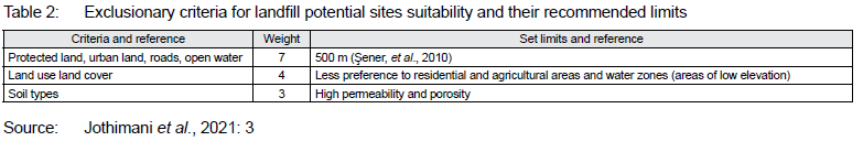
Solid waste disposal is an important part of a waste-management system, which requires much attention to avoid environmental pollution and health problems (Balew et al., 2022: 3). One solid waste management solution is to dispose of solid waste in properly designed and constructed places such as managed landfills, where it is safely contained. Therefore, locating proper sites for solid waste disposal and selecting appropriate landfill sites far from residential areas, environmental resources, and settlements is the main solution for the management of solid waste (Jothimani, Geberslasie & Duraisamy, 2021: 2).
2.2 Site-selection criteria for a solid waste disposal site
Land-use types such as grassland, forests, agricultural land, wetland, and bushlands would be considered and assigned an appropriate index of land-use suitability for solid waste disposal sites (Mussa & Suryabhagavan, 2019b: 5). The importance of minimising the association of conflicting land-use (LU) in solid waste disposal siting can be realised by reviewing locally unwanted land-use areas (Mussa & Suryabhagavan, 2019: 6).
Surface water vicinity: Surface water, rivers, and streams are great natural resources to most African communities, with the New City locality not being an exemption. Rivers and streams are ecosystems that play an important role in supporting marine life and providing water for both domestic and industrial use; they play a big role in the ecological balance, providing a crucial ecosystem service delivery (Biggs, von Fumetti & Kelly-Quinn, 2016: 3). Furthermore, it is crucial to human activities for the vital role it plays in ecological balance. Taking this into consideration, landfills should not be placed close to these resources, in order to mitigate groundwater pollution (Sohoo et al., 2022: 4). Rivers can be endangered by the landfill because of leachate, thus bringing much pollution to the river (Sohoo et al., 2022: 4).
Groundwater depth: Unscientific and improper management of MSW is one of the direct sources of contamination of groundwater in developing countries (Choudhury et al., 2022: 2-3). MSW leads to a decrease in acidity, with increasing depth for groundwater bodies near MSW sites (Choudhury et al., 2022: 2-3). Considering this, a landfill should not be placed close to areas with groundwater, which is near the earth's surface. In other studies, areas with a groundwater depth greater than 50m are suitable for a solid waste disposal site (Balew et al., 2022: 12).
Proximity to nearby settlements: Solid waste disposal sites should not be placed too close to settlement areas and recreation centres (Yildirim et al., 2022: 5). In fact, findings in Turkey by Sener et al. (2010: 6) showed that the distance between disposal sites and settlement areas must be more than 1 000m and the haul distance between the solid waste disposal site and the main city centre should not exceed 30 km.
Proximity to cultural and protected sites: These sites include national heritage sites, shrines of religious importance, animal sanctuaries such as game parks, and areas of national interest. To protect these sites, a solid waste disposal site should be sited as far away as possible from these protected areas (a distance of more than 7 km) (Karimi et al., 2018: 12).
Proximity to roads and railways: Most of the studies suggest that the solid waste dumping site should be located within a 1 km buffer from roads and other transportation facilities to avoid odour pollution (Kumar & Deswal, 2022: 4). Solid waste disposal sites should not be placed too far from the roads, in order to decrease the cost of transportations (Yildirim et al., 2022: 6).
Soil permeability areas that may include liquefaction or subsidence-prone soils, extensive layers of soft soil, anomalous soil characteristics, a high groundwater table, or subsurface cavities should be avoided (Rodwell & Mucina, 1998). The soil map characteristics that are considered most in the selection of a suitable landfill site are permeability and porosity. The constraint on the soil factor is that a site cannot be located on soils that are very permeable and porous (Jothimani et al., 2021: 3).
2.3 GIS applications for site selection
GIS and RS have been used extensively to estimate suitable sites for different phenomena including landfill sites (Majid & Mir, 2021: 1; Mussa & Suryabhagavan, 2019: 1). Thus, GIS and RS both present opportunities for selecting a better solid waste siting technique (Balew et al., 2022: 2). Remotely sensed data has been used widely in introducing different criteria to be used as inputs in the Analytic Hierarchy Process (AHP). In a study to delineate groundwater potential zones in a tropical river basin, remote sensing was used to present the different criteria to be weighed. These criteria included lithology, lineament density, and geomorphology (Achu, Thomas & Reghunath, 2020: 1). In the same study, a GIS, in particular ArcGIS, was used to run the AHP.
Considering the utility of GIS and remote sensing in site selection, it has been extensively combined with MCDA to also site landfills. For instance, studies on a suitable landfill site in Srinagar City used remotely sensed data and multiple criterions, including proximity to road, buildings, water bodies, airport, and residential areas (Majid & Mir, 2021: 1-9). A solid waste dumping site was also estimated for the town of Logia, Ethiopia, that used MCDA and spatial modelling (Mussa & Suryabhagavan, 2019: 1). Furthermore, Isalou et al. (2012: 1) used integrated fuzzy logic, analytic network, spatial analyst, and 3D analyst to overlap criterion layers and analytical processes for site selection. Findings by Akintorinwa and Okoro (2019: 1) combined electrical resistivity method and GIS-based modelling to generate thematic overburden maps for assigning weights, in order to select a suitable landfill site.
2.4 Multi-criteria decision analysis
GIS-based MCDA is a process for combining and converting spatial data into a final result (Balew et al., 2022: 3). The MCDA processes are decision rules that establish a link between input and output maps. MCDA aims to solve problems, by evaluating competing factors in decision-making (Ghosh et al., 2022: 4). To this end, MCDA has been used in various studies to estimate the optimum locations for various phenomena. It has been successfully used for estimating the optimum sites for photovoltaic power plants (Boumaiza, Sanfilippo & Mohandes, 2022: 51), selection of the most suitable site for applying managed aquifer recharge systems (Papadopoulos, 2022: 1), to name a few studies.
GIS is widely used for producing, editing, analysing, and visualising spatial data (Church, 2002: 7). This data will thus be easily accessible to environment planners, ecologists, spatial land planners, and other decision makers. Choosing a landfill site using GIS techniques requires many criteria to be used in one system for proper assessment. The selection method should evaluate multiple criteria such as groundwater, soil type, geology, protected areas, and roads (Karimi et al., 2018: 4). In multi-criteria evaluation, many criterion layers are to be processed by a GIS system to select a suitable site. It is helpful to set appropriate selection criteria for the identification of new solid waste dumping sites through scientific methods.
In as much as these researchers have shown the utility of MCDA and spatial modelling in the estimation of suitable sites, hardly anything has been done to understand the utility of this methodology in estimating suitable landfill sites in Zimbabwe, whose population is ever-growing and a country that still has much free space for urban expansion and, in this case, the New City. Hardly anything has been done to assist decision makers who would use the same information for spatial land planning with a geovisualisation tool, considering that such a tool accessible on any computing device with a web browser will be easily accessible to the different stakeholders in an interactive web viewer (Collado et al., 2022: 2). In fact, a Web-GIS has been successfully implemented for sharing different kinds of information. It has been used, among others, for the geovisualisation of heritage information (Sánchez-Aparicio et al., 2020: 2), and the management of waste collection (Rada, Ragazzi & Fedrizzi, 2013: 2), to name a few.
3. STUDY AREA
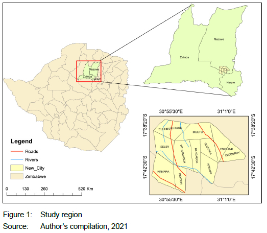
Figure 1 shows the location of the area where the study was carried out in Zimbabwe. It is located 40 km west of Harare, the capital city, with approximately an area coverage of 54.23 km2, and it consists of 11 suburbs. The New City is located in the Mashonaland West, Central, and Harare provinces and comprises farms, human settlements, factories, and mines. The area has some established infrastructure, including, among others, roads, electrical lines, human settlements, and schools. In fact, the New City now houses the new parliament of Zimbabwe as it is expected to be the new commercial capital of Zimbabwe. In proposing a suitable landfill site for the New City, there is a need to consider the existing infrastructure. The study area was chosen as it is a new development in Zimbabwe. As it will be a city, there is a need for optimum siting for solid waste disposal.
4. MATERIALS AND METHODOLOGY
Exploratory research (Casula, Rangarajan & Shields, 2021: 1) was used for the study, with data from both archived and public sources.
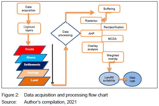
The variables for this study were developed, using expert opinions, previous research studies, as well as relevant legislation and regulations. The data includes environmental, social, and physical factors whose layers were generated in DIVA GIS. The research used heights above sea level. For all the data sets generated in a GIS, the World Geodetic System-WGS1984 system was used as the geographic coordinate system. The criteria's information layers were created with ArcGIS. Data sets and their respective buffers were created on geographical features such as rivers, road networks, and settlements. Each data set, in vector format, was converted to raster data format (vector to raster conversion). The third step dealt with the raster calculator to apply limits (constraints) to each data set map, using ArcGIS tools. Weights were applied to produce the final suitable sites. Figure 2 shows the flowchart followed in the research to derive the suitable estimate areas for the landfill.
4.1 Criteria selection, and standardisation
During the site selection process, criteria with the greatest effect on the selection process must all be addressed (Yildirim et al., 2022: 3). For this study, these criteria were grouped into three main categories, namely environmental, social, and physical. The criteria were assessed on different scales, because it is important to standardise (normalise) criteria before combining them and, if necessary, to modify them so that all criteria maps are positively linked with appropriateness (Seyedmohammadi et al., 2018: 4).
4.1.1 Environmental criteria
Suitability of subsurface soil: The soils in the New City were grouped into 3 groups and included Hypoluvic Arenesols (11.02%), Haplic Lixisols (0.07%), and Ferralic Cambisols (60.62%) (Xiao et al., 2016: 4). Their permeability and porosity were used to define the criteria classification of the soil in the New City. Hypoluvic Arenesols have high profile development but are very porous and have high permeability, whereas Ferralic Cambisols have very low permeability and are highly drained (Xiao et al., 2016: 4). The soil groups with the lowest permeability and porosity were assigned the highest suitability score (Dewitte et al., 2013: 5).
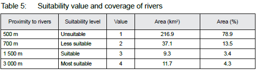
Proximity to rivers: The study area comprises rivers and multiple streams running acrass it. Hence, in order to avoid water pollution, buffer zones of 500 m, 700 m and 1 000 re were created around these weter surfaces and classified into four categories, as shown in Figure 6. The 0 to 500 m buffe r was considered unswtable; 500 to 700 m buffer as less suitable; the 700 to 1 500 m buffer as suitable, and the 1 500 to 3 000 m buffer as the most suitable sites (Kumar & Deswal, 2022: 6).
Land-use and land-cover changes: The land-use map was divided into 5 classes. Bare area occupying 3% was given the highest suitability score, followed by the forest, 58.05% and given the second priority, and agriculture, 21%, followed by urban area occupying 1.90% (Sohoo et al., 2022: 7). The open water surfaces occupying 0.15% of the study area were given zero suitability.
4.1.2 Social criteria
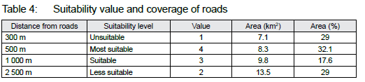
Proximity to roads: For easy accessibility, landfills must always be situated near road proximity so as not to compromise waste-collection and transportation costs (Jothimani, Geberslasie & Duraisamy, 2021: 4). This notwithstanding, it should not be located too close to the road so as to prevent environmental pollution and aesthetic damage. Using ArcGIS, multi-ring buffer zones of roads with 300 m,500 m,1 000 m, and 2 500 m were created (Jothimani et al., 2021: 4). Only the available main and proposed roads were considered, with a 0 to 300m buffer as unsuitable and a 300 to 500 m buffer as most suitable, whereas 500 to 1 000 m buffer as suitable and 1 000 to 2 500 m buffer as less suitable for waste disposal site location.
4.1.3 Physical criteria
Proximity to protected areas: Like Asefa et al. (2013: 5), this study considered churches, settlements, and schools as protected areas that need to be located away from landfill sites because of the presence of high population concentration in these areas. Buffer zones of the following classes were created: 0 to 500 m as unsuitable, 500 to 1 000 m as less suitable, 1 000 to 1 500 m as suitable, and 1 500 to 5 000 m as most suitable. This means that the suitability of a landfill site increases as the presence of population decreases.
4.2 Determination of criteria weights
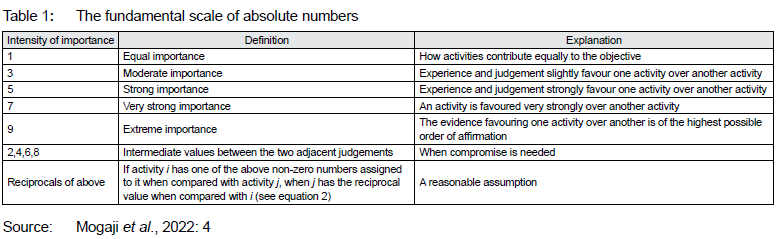
In spatial analysis, problems involve criteria of varying importance to decision makers (see Table 1). Thus, information about the relative importance of the criteria is required. A weight is a value assigned to an assessment criterion that indicates its relevance in comparison to other criteria being considered. The greater weight the criterion has in the total usefulness, the more significant it is (Seyedmohammadi et al., 2018: 5). Weights may be developed using a variety of methods. In extremely simple instances, splitting 1.0 among the criteria might be used to give criteria weights. It becomes difficult to perform weight judgements on the whole data set when more than a few criteria are involved, and several variables apply. After that, the weights are generally adjusted to equal one. Some of the most popular methods for the development of weights (Seyedmohammadi et al., 2018: 5) are ranking, rating, and pairwise comparison. In this study, the criterion weights were evaluated, using the ranking method.
4.3 GIS-based MCDA data processing
To find the optimum site for a landfill in the New City, the researchers used MCDA theory approaches in a GIS context. MCDA is a decision-making technique that employs the identification and choosing of criteria to find the best solution based on different weighted factors and considering the decision makers' expectations (Mateo, 2012: 25). MCDA supports decision-making processes through the analysis of multiple inputs at several levels of description, including economic, technical, social, and environmental factors (Adamczyk & Watdykowski, 2022: 1). It is worth mentioning that there are various methods of implementing MCDA. For this study, the following MCDA approaches were used:
• A binary overly (Boolean logic) (Singh, Jha & Chowdary, 2017: 3)) method, for determining potential site areas, using five constraints;
• Weighted Linear Combination (WLC) (Adamczyk & Watdykowski, 2022: 2) method, for selecting candidate sites (alternatives) from potential site areas, using five factors, and
• AHP (Ghosh et al., 2022: 2) method, for determining preferred candidate sites from potential sites.
4.3.1 Binary overlay methods (Boolean logic)
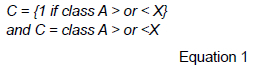
Considering that each site for siting a MSW landfill is either good or not, the result is a binary map, hence the need to use Boolean logic in the study. Boolean Logic is mostly used in the early screening stages or in stages where unusable options for usable alternatives are divided (Adamczyk & Watdykowski, 2022: 3). The number of classes is determined by whether or not the desired requirement is accurate, and the final output expression is applied to each variable (Wu et al., 2007: 15). These variables were used to specify two classes multiple times. For the targeted location and the output of a new map, these classes were 0 and 1, respectively.
Equation 1 defines Boolean logic, which converts relevant information from each input map into binary form (True or False) or (0 and 1):
4.3.2 Weighted Linear Combination
The WLC technique is based on the decision maker's weighting of each criterion. A total score is calculated for each choice, by multiplying the allocated weight value with a scaled value by the criterion (Hwang, 2011: 3). Each alternative is evaluated separately for each criterion if there are m number of choices and n number of criteria. The weights assigned to each criterion reflect its relevance in relation to the other criteria. Following that, the weighted average score for all options is determined using Equation 2 (Hwang, 2011: 3).
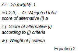
WLC is built on the notion of a weighted average, in which continuous criteria are standardised to a common numeric range and then merged using a weighted average (Mallick et al., 2022: 6). The decision maker gives relative significance weights to each attribute map layer directly. The overall score for each alternative is calculated, by multiplying the significance weight allocated to each attribute by the scaled value assigned to that characteristic in the alternative, then adding the products across all attributes (Mallick et al., 2022: 6). The scores for all of the options are totalled, and the one with the highest overall score is picked. The approach may be used with any GIS system that supports overlays, and allows the evaluation criterion map layers to be merged to produce the composite map layer, which is the final result (Yin et al., 2020: 7). The weighted linear combination technique combines elements, by assigning a numerical value to each one. Following that, the findings are summed to provide a suitability map.
4.3.3 Analytic hierarchy process method
For decision analysis, the AHP method provides the best performing model of decision-making (Mojaver et al., 2022; Andreolli et al., 2022; Noorollahi et al., 2022; Belay et al., 2022), as it has proven over time to be a well-established method to address complex decisions and obtain a priority ranking of alternatives (Mogaji et al., 2022: 4).
The AHP allows for the quantitative and/or qualitative evaluation of criteria and factors on the same measurement scale and the recreation of the original decision factor into a hierarchy, in which the hierarchical links between stages and levels are developed (Andreolli et al., 2022: 3). The upper part of the hierarchy is shown as the main objective of the decision problem. However, all the other criteria contributing to the objective are placed at lower levels and other alternative factors to be evaluated are placed at the bottom (Andreolli et al., 2022: 2). The weights of each criterion are determined through pairwise comparisons generated in semantic judgements.
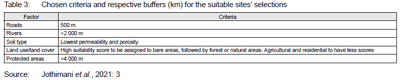
Each alternative is compared pairwise with respect to a specific criterion to obtain the scores (x1... xnn) of alternatives, where x1 is the first alternative to the nth alternative xn. The eigenvectors are obtained after normalising the judgemental matrices. Sisay et al. (2020: 4) used the lambda max technique to obtain criteria weights, by applying the pairwise comparison method. Alternatives are compared pairwise with respect to each criterion to obtain weights (w1...wn), where w1 is the weight of the first alternative to the weight of the nth alternative given by wn. in the study. Table 3 indicates the criteria chosen for selecting the suitable sites.
4.4 Web-GIS Application development and results exportation
After generating a mapping product, there is a need to ensure that the products, for instance, suitability maps, could easily be used by a wide audience. A Web-GIS provides easy-to-use tools for the geovisualisation of any mapped product that will help decision makers in spatial planning, by using technologies with which they are already familiar, in this case any computing device with an internet browser and internet connectivity (Collado et al., 2022: 2). Distributing geospatial information on the internet allows different users with varying levels of literacy to use GIS systems to easily interact with a GIS on a web browser. In fact, a web browser and the internet allow all levels of society to access geospatial information. It provides a media for accessing geo-related information with no location restrictions. The technology has been used for the geovisualisation of different phenomena, including the geovisualiation of transport infrastructure (Mazhindu & Madamombe, 2022: 2). For this study, the results or extracted suitable areas were exported to HTML, Javascript, and CSS, which are web-mapping technologies using a QGIS plugin - QGIS2Web, for geovisualisation on a web-GIS that allows data on landfill site selection to be accessed over the internet.
5. RESULTS
5.1 Roads
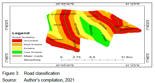
Figure 3 shows the suitability map considering distances to roads. The results show that areas represented with a brown colour are most suitable for citing a landfill. Approximately 60% of the area is unsuitable for the landfill site when considering proximity to roads, as shown in Table 4, with central areas such as Bendauch and Komani having the largest areas of unsuitable sites. Areas such as Kinvara and Haydon have a larger spatial extent of most suitable area for a landfill site.
5.2 Proximity to rivers
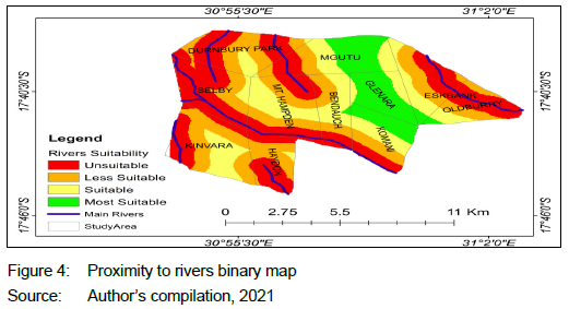
Figure 4 shows the suitability map considering distances to rivers. Results show that areas represented with a green colour and located in the east part of the map extending from Mgutu to Glenara and Komani are most suitable for siting a landfill based on proximity to rivers. Approximately 8% is most suitable and suitable for the landfill site, as shown in Table 5, with central areas such as Bendauch, Selby, Durnbury Park, and Mt. Hampden having the largest areas of unsuitable sites. Areas such as Kinvara and Haydon have some parts of spatial extent of suitable areas for landfill site.
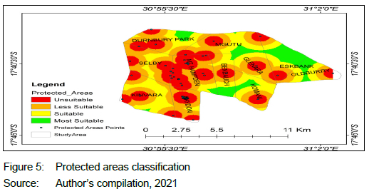
5.3 Proximity to protected areas
Figure 5 shows the suitability map considering proximity to protected areas (churches, settlements, and schools). Results show that the areas represented with a green colour and located in the east part of the map extending from Mgutu to Glenara and Komani are most suitable for siting a landfill based on proximity to protected areas. In Figure 5, a small area is suitable for the landfill site, with central areas such as Bendauch, Selby, Durnbury Park, and Mt. Hampden having the largest areas of unsuitable sites. Areas such as Kinvara and Haydon have some parts spatial extent of suitable areas for a landfill site.
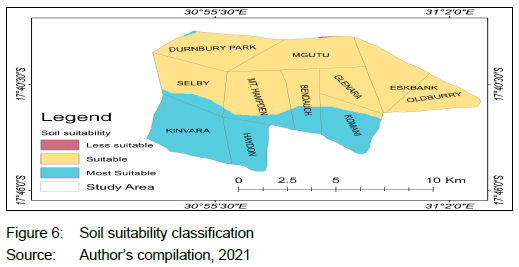
5.4 Soil suitability
Figure 6 shows suitability classes for soils, with suitable areas occupying the largest area, moderately deep to deep, reddish brown granular clays; formed on mafic rocks, extending from the northwest to the southeast, with a colour code of brown. The most suitable areas were identified in the study area, extending from the northwest to the southeast, with a colour code of blue covering suburbs such as Kinvara, Haydon and part of Selby, Mt. Hampden, Komani, Bendauch, and Durnburry Park. A low suitability area was identified on the edges of Mgutu suburb in a northern direction.
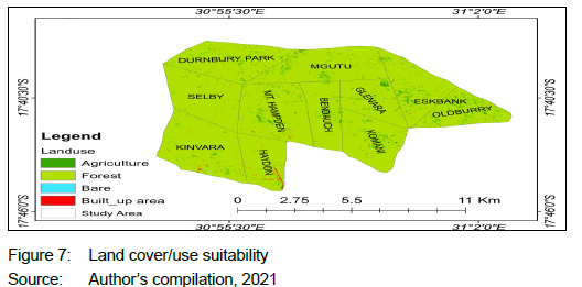
5.5 Land cover/use suitability
Figure 7 shows suitability classes for land cover and land use, with built-up areas detected mostly in suburbs such as Haydon, Kinvara, Mt. Hampden, thus the southern part of the study area and partially in Komani, Glenara, and Eskbank, thus the eastern parts of the study area. Agricultural activities were detected as dominating nearly every portion of the study area, mostly in the northern and eastern parts of the study area in suburbs such as Mgutu, Glenara, Durnbury Park, and Eskbank. Bare areas were detected in Kinvara and Hydon, however, at smaller areas.
5.6 Determining suitable map based on weights from Analytical Hierarchy Process
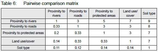
The AHP was used to derive the weights for each element. This method consisted of ranking the elements according to their relative importance in the siting process, using the pairwise comparison matrix (see Table 6). From the pairwise comparison matrix, the eigenvector weight was derived in ArcGIS and presented in percentages (see Table 7).
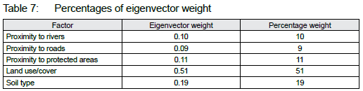
The eigenvector weights derived from the AHP were attributed to their respective raster layers and with the use of the weighted overlay tool they were all weighted together to produce the suitability map in Figure 8.
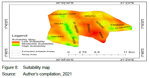
5.7 Final suitability map
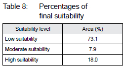
Results in Table 8 and Figure 8 show that approximately 18% (green areas on map) of the New City is highly suitable for siting a landfill. Moderately suitable areas cover approximately 8% (yellow areas on map). A further 73% (red areas on map) of the total land area in the study area is highly unsuitable for siting a landfill.
Areas in the western parts such as Durnbury Park, Kinvara, Selby, Mt Hampden, and Haydon and areas in the eastern part such as Oldburry an d Eskbank are more suitable for siting alandfill site. Areas such as Bendauchm Komani, and Mgutu have a low suitability.
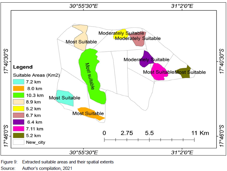
5.8 Extraction of suitable areas
Figure 9 shows the extraction of final suitable areas considering all the criteria merged together. The aim was to observe and measure the spatial extents suitable areas. The largest spatial extent observed was a 10 km2 covering from Durnbury Park to Haydon in a north to south direction. The northern part has moderately suitable areas with a combined spatial extent of 11.9 km2, in Mgutu and Eskbank. The extracted results were overlaid on top of the Google Hybrid Satellite in QGIS for near real-time visualisation of suitable areas, as demonstrated in Figure 9.
5.9 Near real-time analysis of any changes in the study area
The study area was used to demarcate the are a of interest,as shown in Figure 10. Ana nalysis was made based on the Google hybrid satellite toidentify changes before overlaying the extracted suitable areas. The analysis helped limit the process to only select areas that meet the selection criteria, thus eliminating suburbs such as Kinvara, Hydon, and Mt. Hampden, which are located in the southwest, as they show residential infrastructure. Other suburbs such as Mgutu, Bendauch, and Komani are showing either complete or partial agricultural activities. Hence, this eliminates them during the overlay process with the extracted predicted suitable areas. However, other areas such as Oldburry, Eskank, and Durnbury Park have some parts that satisfy the landfill site selection conditions, namely away from protected areas, agricultural activities, rivers, and 500 m from roads.
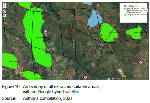
5.10 Suitable areas and Google hybrid satellite overlay
Figure 10 shows an overlay of the final extracted suitable areas with a near real-time satellite to visualise any changes in the study region. The largest predicted suitable area (10 km2) was predicted on top of already built-up infrastructures, for example Zimbabwe's new parliament building. Other predicted suitable areas were overlaid and identified to be on top of agricultural activities and residential areas. However, some areas were correctly predicted as they were far away from rivers or streams, protected areas, and agricultural activities, thus the suitable area Oldburry city in the south-eastern part of the study area. Figure 10 also shows a Web-GIS for near real-time change detection and suitable area selection.
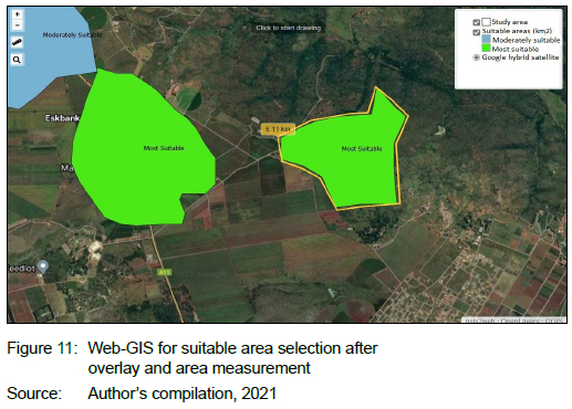
5.11 Web-GIS visualisation of suitable area, measurement, and selection
Figure 11 shows the selected suitable areas located away from residential areas and agricultural activities, but close to road network for easier transportation within the study area. The web-GIS measuring tool was used to measure the total area for the selected suitable area. The total area was 6.11 km2.
6. DISCUSSION
The results from Boolean integration of reclassified raster layers show that the bigger area in New City is unsuitable for siting a landfill site and only a smaller percentage is suitable according to the predefined criteria. However, it is not always the case to find unsuitable and suitable sites treating each criterion as equally important. All classified raster layers went through weighted overlay technique, where weights were assigned to each reclassified layer and then integrated to produce final suitability maps with areas ranging from least suitable to most suitable sites (Jothimani et al., 2021). Findings show the areas that are suitable according to weighted overlay, using AHP. These findings will greatly assist spatial and town planners for the New City in the siting of an appropriate landfill site and in the process assist in the siting of other land zones such as, for instance, residential areas and the central business district.
The results also prove that, given a range of factors as a standard for locating a suitable site, they are not equally important to each other and thus need to be ranked and assigned a certain weight that will be used to produce a final suitability map. The final map that was produced indicated areas that are not suitable, suitable, fairly suitable, and moderately suitable for siting a landfill site.
The results show that areas of high viability, including Kinvara, Haydon and part of Selby, Mt. Hampden, Komani, Bendauch, and Durnburry Park, have ferralic cambisols type of soils with low diffusion coefficient and are less porous, preventing groundwater pollution through infiltration. According to studies, landfills are most suitable in areas with less permeable soils and less porous soils, which prevent groundwater contamination if water continues to penetrate within the soils, putting public health at risk (Khademalhoseiny, Ahmadi Nadoushan & Radnezhad, 2017: 5).
Clarke (2015: 2) postulates that landfills create detrimental gases and leakage, making them unfit to be in proximity to surface waters. Since landfill is characterised by several types of waste, its pollution capabilities are high. Henceforth, to avoid pollution of rivers and transmission of hazardous chemicals into underground water, which can lead to bio-accumulation of chemicals in the enact species, a landfill must be located far away from streams, rivers, and water reservoirs. Landfills located near water surfaces have resulted in the death of aquatic life and health implications for the people who depend on surface water sources for domestic use.
A web-GIS based on QGIS was also successfully implemented, using the QGIS2WEB plugin on QGIS for the geovisualisation of the proposed areas for solid waste disposal sites. A web-GIS makes the results of this research readily available to anyone who has access to a web browser, thus facilitating the sharing of information.
7. CONCLUSIONS
The study resulted in optimal sites being identified, analysed, and weighted. A criterion was used based on factors such as water sources, protected areas, soil, road, rivers, and boundary. The study shows that MCDA can be successfully implemented to site a landfill for a developing country such as Zimbabwe that has abundant land for development and an ever-growing population. Furthermore, it is interesting to note that Web-GIS can be successfully implemented to assist decision makers in the management of landfills and MSW. In fact, the geovisualisation of the suitable sites assists decision makers wherever they are, regardless of geographic location, to visualise the suitable areas in relation to features to which they can relate on a map. This enables them to access geospatial data on any device with a web browser, without the need to install GIS software and to learn how to use the same GIS software.
This study can be developed further by integrating the boundaries of the New City when it has been gazetted by the responsible government. Furthermore, the area has artisanal miners and these areas should also be sites to avoid.
REFERENCES
ABDALQADER, A.F. 2011. Landfills needs assessment in Gaza strip and sites selection using GIS. Unpublished thesis (master's in civil engineering). The Islamic University of Gaza, Gaza, Palestine. [ Links ]
ASEFA, T. & ADAMS, A. 2013. Reducing bias-corrected precipitation projection uncertainties: A Bayesian-based indicator-weighting approach. Regional Environmental Change, 13(SUPPL.1). https://doi.org/10.1007/s10113-013-0431-9 [ Links ]
ACHU, A.L., THOMAS, J. & REGHUNATH, R. 2020. Multi-criteria decision analysis for delineation of groundwater potential zones in a tropical river basin using remote sensing, GIS and analytical hierarchy process AHP. Groundwater for Sustainable Development, 10, article 100365. doi.org/10.1016/J.GSD.2020.100365 [ Links ]
ADAMCZYK, J. & WALDYKOWSKI, P. 2022. Planning for sustainable development of tourism in the Tatra National Park Buffer Zone using the MCDA approach. Miscellanea Geographica, 26(1), pp. 42-51. doi.org/10.2478/mgrsd-2020-0067 [ Links ]
AKINTORINWA, O.J. & OKORO, O.V. 2019. Combine electrical resistivity method and multi-criteria GIS-based modeling for landfill site selection in southwestern Nigeria. Environmental Earth Sciences, 78(5), article 785, pp. 1-16. doi.org/10.1007/S12665-019-8153-Z [ Links ]
ANDREOLLI, F., BRAGOLUSI, P., D'ALPAOS, C., FALESCHINI, F. & ZANINI, A. 2022. An AHP model for multiple-criteria prioritization of seismic retrofit solutions in gravity-designed industrial buildings. Journal of Building Engineering, 45, article 103493. doi.org/10.1016/J.JOBE.2021.103493 [ Links ]
BALEW, A., ALEMU, M., LEUL, Y. & FEYE, T. 2022. Suitable landfill site selection using GIS-based multi-criteria decision analysis and evaluation in Robe town, Ethiopia. GeoJournal, 87(2), pp. 895-920. doi.org/10.1007/s10708-020-10284-3 [ Links ]
BELAY, S., GOEDERT, J., WOLDESENBET, A. & ROKOOEI, S. 2022. AHP based multi criteria decision analysis of success factors to enhance decision making in infrastructure construction projects., 9(1). https://doi.org/10.1080/23311916.2022.2043996 [ Links ]
BIGGS, J., VON FUMETTI, S. & KELLY-QUINN, M. 2016. The importance of small waterbodies for biodiversity and ecosystem services: Implications for policy makers. Hydrobiologia, article 7931, pp. 3-39. doi.org/10.1007/S10750-016-3007-0 [ Links ]
BOUMAIZA, A., SANFILIPPO, A. & MOHANDES, N. 2022. Modeling multi-criteria decision analysis in residential PV adoption. Energy Strategy Reviews, 39, pp. 100789. doi.org/10.1016/J.ESR.2021.100789 [ Links ]
BUTT, N. A., KHAN, M. Y., KHATTAK, S. A., AKHTER, G., GE, Y., SHAH, M. T., & FARID, A. 2022. Geophysical and Geochemical Characterization of Solidwaste Dumpsite: A Case Study of Chowa Gujar, Peshawar (Part of Indus Basin). Sustainability (Switzerland), 14(3). https://doi.org/10.3390/su14031443 [ Links ]
CASULA, M., RANGARAJAN, N. & SHIELDS, P. 2021. The potential of working hypotheses for deductive exploratory research. Quality and Quantity, 55, pp. 1703-1725. doi.org/10.1007/S11135-020-01072-9/TABLES/4 [ Links ]
CHOUDHURY, M., JYETHI, D.S., DUTTA, J., PURKAYASTHA, S.P., DEB, D., DAS, R., ROY, SEN, G.T. & BHATTACHARYYA, K.G. 2022. Investigation of groundwater and soil quality near to a municipal waste disposal site in Silchar, Assam, India. International Journal of Energy and Water Resources, 6, pp. 37-47. doi.org/10.1007/s42108-021-00117-5 [ Links ]
CHURCH, R.L. 2002. Geographical information systems and location science. Computers & Operations Research, 29(6), pp. 541-562. https://doi.org/10.1016/S0305-0548(99)00104-5 [ Links ]
CLARKE, B. O., ANUMOL, T., BARLAZ, M., & SNYDER, S. A. 2015. Investigating landfill leachate as a source of trace organic pollutants. Chemosphere, 127, pp. 269-275. https://doi.org/10.1016/j.chemosphere.2015.02.030 [ Links ]
COLLADO, A., MORA-NAVARRO, G., HERAS, V. & LERMA, L. 2022. A web-based geoinformation system for heritage management and geovisualisation in cantón nabón Ecuador. ISPRS International Journal of Geo-Information, 11(1), article 4. doi.org/10.3390/ijgi11010004 [ Links ]
DE LA CROIX, D. & GOBBI, P.E. 2022. Population homeostasis in sub-Saharan Africa. Economics and Human Biology, vol. 45, article 101102. doi.org/10.1016/j.ehb.2021.101102 [ Links ]
DEWITTE, O. et al. 2013. Harmonisation of the soil map of Africa at the continental scale. Geoderma, 211-212, pp. 138-153. doi.org/10.1016/J.GEODERMA.2013.07.007 [ Links ]
GHOSH, A., ADHIKARY, P.P., BERA, B. & BHUNIA, G.S. 2022. Assessment of groundwater potential zone using MCDA and AHP techniques: Case study from a tropical river basin of India. Applied Water Science, 12, article 37. https://doi.org/10.1007/s13201-021-01548-5 [ Links ]
HWANG, R.C. 2011. Asymptotic properties of locally weighted regression. Journal of Nonparametric Statistics, 5(3), pp. 303-310. doi.org/10.1080/10485259508832650 [ Links ]
ISALOU, A.A., ZAMANI, V., SHAHMORADI, B. & ALIZADEH, H. 2012. Landfill site selection using integrated fuzzy logic and analytic network process F-ANP. Environmental Earth Sciences, 68, pp. 1745-1755. doi.org/10.1007/S12665-012-1865-Y [ Links ]
JOTHIMANI, M., GEBERSLASIE, A. & DURAISAMY, R. 2021. Suitable sites identification for solid waste disposal using Geographic Information System and Analytical Hierarchy Process Method in Debark Town, Northwestern Ethiopia. IOP Conference Series: Earth and Environmental Science, vol. 795, pp. 1755-1315. doi.org/10.1088/1755-1315/795/1/012016 [ Links ]
KARIMI, H., AMIRI, S., HUANG, J. & KARIMI, A. et al. 2018. Integrating GIS and multi-criteria decision analysis for landfill site selection, case study: Javanrood County in Iran. International Journal of Environmental Science and Technology, 16(11), pp. 7305-7318. doi.org/10.1007/S13762-018-2151-7 [ Links ]
KHADEMALHOSEINY, M.S., AHMADI NADOUSHAN, M. & RADNEZHAD, H. 2017. Site selection for landfill gas extraction plant by fuzzy analytic hierarchy process and fuzzy analytic network process in the city of Najafabad, Iran. Energy & Environment, 28(7), pp. 763-774. doi.org/10.1177/0958305X17728692 [ Links ]
KUMAR, S. & DESWAL, S. 2022. Comparative assessment of Kurukshetra City waste dumping sites using RIAM analysis: A case study. Lecture Notes in Civil Engineering, vol. 154, pp. 31-38. doi.org/10.1007/978-981-16-1993-9_4 [ Links ]
LYONS, E., ZHANG, P., BENN, T., SHARIF, F., LI, K. & CRITTENDEN, J. 2009. Life cycle assessment of three water supply systems: Importation, reclamation and desalination. Water Supply, 9(4), pp. 439-448. doi.org/10.2166/WS.2009.534 [ Links ]
MAJID, M. & MIR, B.A. 2021. Landfill site selection using GIS-based multi-criteria evaluation technique. A case study of Srinagar City, India. Environmental Challenges, 3, article 100031. doi.org/10.1016/J.ENVC.2021.100031 [ Links ]
MALLICK, J. et al. 2022. GIS-based decision support system for safe and sustainable building construction site in a mountainous region. Sustainability, 14(2), article 888. doi.org/10.3390/su14020888 [ Links ]
MATEO, J.R.S.C. 2012. Multi-criteria analysis. Green Energy and Technology, 83, pp. 7-10. doi.org/10.1007/978-1-4471-2346-0_2 [ Links ]
MAZHINDU, A.N. & MADAMOMBE, H.K. 2022. Design and implementation of a Web-GIS for the management of road infrastructure in Zimbabwe. South African Journal of Geomatics, 11(1), pp. 53-64. doi.org/10.4314/sajg.v11i1.5 [ Links ]
MOGAJI, K.A., ATENIDEGBE, O.F., ADEYEMO, I.A. & AKINMULEWO, K.P. 2022. Application of GIS-based PROMETHEE data mining technique to geoelectrical-derived parameters for aquifer potentiality assessment in a typical hardrock terrain south-western Nigeria. Sustainable Water Resources Management, 82, article 54. doi.org/10.1007/s40899-022-00616-1 [ Links ]
MOHAMMAD, A., SINGH, D., PODLASEK, A., OSINSKI, P. & KODA, E. 2022. Leachate characteristics: Potential indicators for monitoring various phases of municipal solid waste decomposition in a bioreactor landfill. Journal of Environmental Management, 309, article 114683. doi.org/10.1016/j.jenvman.2022.114683 [ Links ]
MOJAVER, M., HASANZADEH, R., AZDAST, T. & PARK, C.B. 2022. Comparative study on air gasification of plastic waste and conventional biomass based on coupling of AHP/ TOPSIS multi-criteria decision analysis. Chemosphere, 286, article 131867. https://doi.org/10.1016/J.CHEMOSPHERE.2021.131867 [ Links ]
MUHEIRWE, F., KOMBE, W. & KIHILA, J.M. 2022. The paradox of solid waste management: A regulatory discourse from sub-Saharan Africa. Habitat International, vol. 119, article 102491. doi.org/10.1016/j.habitatint.2021.102491 [ Links ]
MUSSA, A. & SURYABHAGAVAN, K.V. 2019. Solid waste dumping site selection using GIS-based multi-criteria spatial modeling: A case study in Logia Town, Afar region, Ethiopia. Geology, Ecology, and Landscapes, 5(3), pp. 186-198. doi.org/10.1080/24749508.2019.1703311 [ Links ]
NAIBBI, A.I. & UMAR, M. 2017. An appraisal of spatial distribution of solid waste disposal sites in Kano Metropolis, Nigeria. Journal of Geoscience and Environment Protection, 5(11), pp. 24-36. doi.org/10.4236/GEP.2017.511003 [ Links ]
NHUBU, T., MUZENDA, E., MOHAMED, B. & MBOHWA, C. 2021. Framework for decentralizing municipal solid waste management in Harare, Zimbabwe. Advances in Science, Technology and Engineering Systems Journal, 6(2), pp. 1027-1039. doi.org/10.25046/aj0602117 [ Links ]
NOOROLLAHI, Y., GHENAATPISHEH SENANI, A., FADAEI, A., SIMAEE, M., & MOLTAMES, R. 2022. A framework for GIS-based site selection and technical potential evaluation of PV solar farm using Fuzzy-Boolean logic and AHP multi-criteria decision-making approach. Renewable Energy, 186, pp. 89-104. https://doi.org/10.1016/J.RENENE.2021.12.124 [ Links ]
NTA, S., AYOTAMUNO, M., IGONI, A., OKPARANMA, R. & BENJAMIN, E. 2020. Municipal solid waste characterization and its associated vector-borne diseases within the vicinity of dumpsite and controlled site. International Journal of Tropical Disease & Health, 41(1), pp.1-9. doi.org/10.9734/ijtdh/2020/v41i130238 [ Links ]
PAPADOPOULOS, C. 2022. Hybrid fuzzy multi-criteria analysis for selecting discrete preferable groundwater recharge sites. Water, 14(1), article 107. doi.org/10.3390/W14010107 [ Links ]
RADA, E.C., RAGAZZI, M. & FEDRIZZI, P. 2013. Web-GIS-oriented systems viability for municipal solid waste selective collection optimization in developed and transient economies. Waste Management, 33(4), pp. 785-792. doi.org/10.1016/J.WASMAN.2013.01.002 [ Links ]
RODWELL, J. & MUCINA, L. 1998. Phytosociological relationships of EUNIS habitats: Scientific background to the EUNIS habitat classification. Vegetation of Africa View project. Available at: <https://www.researchgate.net/publication/40158922> [Accessed: 23 March 2022]. [ Links ]
SÁNCHEZ-APARICIO, L.J., MASCIOTTA, M.G., ALVARE, J.C., RAMOS, L.F. et al. 2020. Web-GIS approach to preventive conservation of heritage buildings. Automation in Construction, vol. 118, article 103304. doi.org/10.1016/J.AUTCON.2020.103304 [ Links ]
SENER, SENER, E., NAS, B. & KARAGÜZEL, R. 2010. Combining AHP with GIS for landfill site selection: A case study in the Lake Beysehir catchment area Konya, Turkey. Waste Management, 30(11), pp. 2037-2046. doi.org/10.1016/J.WASMAN.2010.05.024 [ Links ]
SEYEDMOHAMMADI, J., SARMADIAN, F., JAFARZADEH, A., GHORBANI, A. & SHAHBAZI, F. 2018. Application of SAW, TOPSIS and fuzzy TOPSIS models in cultivation priority planning for maize, rapeseed and soybean crops. Geoderma, vol. 310, pp. 178-190. doi.org/10.1016/j.geoderma.2017.09.012 [ Links ]
SILVA DE SOUZA LIMA CANO, N., IACOVIDOU, E. & RUTKOWSKI, E.W. 2022. Typology of municipal solid waste recycling value chains: A global perspective. Journal of Cleaner Production, vol. 336, article 130386. doi.org/10.1016/j.jclepro.2022.130386 [ Links ]
SINGH, L.K., JHA, M.K. & CHOWDARY, V.M. 2017. Multi-criteria analysis and GIS modeling for identifying prospective water harvesting and artificial recharge sites for sustainable water supply. Journal of Cleaner Production, 142(4), pp. 1436-1456. doi.org/10.1016/j.jclepro.2016.11.163 [ Links ]
SISAY, G., GEBRE, S.L. & GETAHUN, K. 2020. GIS-based potential landfill site selection using MCDM-AHP modeling of Gondar Town, Ethiopia. African Geographical Review, 40(2), pp. 105-124. doi.org/10.1080/19376812.2020.1770105 [ Links ]
SOHOO, I., RITZKOWSKI, M., GUO, J., SOHOO, K. & KUCHTA, K. 2022. Municipal solid waste management through sustainable landfilling: In view of the situation in Karachi, Pakistan. International Journal of Environmental Research and Public Health, 19(2), article 773. doi.org/10.3390/ijerph19020773 [ Links ]
SULTANA, M., JAHIRUDDIN, M., ISLAM, M.R., RAHMAN, M.M., ABEDIN, M.A. & SOLAIMAN, Z.M. 2021. Article nutrient enriched municipal solid waste compost increases yield, nutrient content and balance in rice. Sustainability, 13(3), article 1047. doi.org/10.3390/su13031047 [ Links ]
VISVANATHAN, C.U.G. 2006. Domestic solid waste management in South Asian countries: A comparative analysis. In: Promoting Reduce, Reuse, and Recycle in South Asia. Synthesis Report of 3R South Asia Expert Workshop Kathmandu, Nepal, 30 August-1 September, pp. 27-38. [ Links ]
WU, X. et al. 2007. Top 10 algorithms in data mining. Knowledge and Information Systems, 14(1), pp. 1-37. doi.org/10.1007/S10115-007-0114-2 [ Links ]
XIAO, Z., JIANG, L., ZHU, Z., WANG, J. & DU, J. 2016. Spatially and temporally complete satellite soil moisture data based on a data assimilation method. Remote Sensing, 8(1), article 49. doi.org/10.3390/rs8010049 [ Links ]
YILDIRIM, V., UZUN, B., BAYKAL, T., TERZI, F. & ATASOY, B. 2022. Odor-aided analysis for landfill site selection: Study of DOKAP Region, Turkey. Environmental Science and Pollution Research, 29(7), pp. 10754-10770. doi.org/10.1007/s11356-021-16474-x [ Links ]
YIN, S. et al. 2020. Optimization of the weighted linear combination method for agricultural land suitability evaluation considering current land use and regional differences. Sustainability, 12(23), article 10134. doi.org/10.3390/SU122310134 [ Links ]
Received: August 2022
Peer reviewed and revised: January 2022
Published: June 2023
* The author(s) declared no potential conflicts of interest with respect to the research, authorship, and/or publication of this article

