


Servicios Personalizados
Articulo
 Inglés (pdf)
 Articulo en XML
 Referencias del artículo
Indicadores

Links relacionados
-
 Citado por Google
 -
 Similares en Google
Compartir

 Permalink
Town and Regional Planning
versión On-line ISSN 2415-0495
versión impresa ISSN 1012-280X
Town reg. plan. (Online) vol.82 Bloemfontein 2023
http://dx.doi.org/10.18820/trp.v82i.6632
RESEARCH ARTICLE
Differential urbanisation for settlement planning - A Western Cape case study
Differensiële verstedeliking vir nedersettingsbeplanning - 'N wes-kaap-gevallestudie
Phetoho ea litoropo bakeng sa moralo oa bolulo -boithuto ka Western Cape
Peter MagniI, *; Mari SmithII; Helena JacobsIII; Natasha MurrayIV, *
Icorresponding author), Western Cape Department of Environmental Affairs and Development Planning, Cape Town, South Africa. Email: peter.magni@westerncape.gov.za
IIWestern Cape Department of Environmental Affairs and Development Planning, Cape Town, South Africa. Email: mari.botha@westerncape.gov.za
IIIWestern Cape Department of Environmental Affairs and Development Planning, Cape Town, South Africa. Email: helena.jacobs@westerncape.gov.za
IVWestern Cape Department of Environmental Affairs and Development Planning, Cape Town, South Africa. Email: natasha.murray@westerncape.gov.za
ABSTRACT
The differential urbanisation model is a means to assess settlement growth rates. While the model has been tested primarily at a national level, including in South Africa, this study seeks to apply the analysis to the sub-national scale in the Western Cape province and Cape Winelands district municipality. The study found that the model is applicable to both the province and the district municipality. Settlements of differing size and economic importance grew at varying rates relative to each other in a predictable sequence, which realised the urban hierarchy, over a 20-year period. This finding was unexpected, given that the urban differential model assumes economic growth as well as labour and socio-economic homogeneity - factors that have not been realised evenly sub-nationally. The applicability of the model to these locations may assist in the public division of resources, particularly in small towns, where meaningful urbanisation occurs, yet capital allocations are limited. The applicability of the study is in keeping with national, provincial, and municipal trends in planning that emphasise the interrelationship between settlements of different size and function over time, and the importance of spatial planning in guiding public infrastructure expenditure.
Keywords: Differential urbanisation, infrastructure planning, settlement growth rates, settlement planning, spatial planning, urban hierarchy
OPSOMMING
Die differensiële verstedelikingsmodel is 'n metode om die groeitempo van nedersettings te beoordeel. Die toepassing van die model is hoofsaaklik getoets op nasionale vlak, Suid-Afrika ingesluit. Hierdie studie ondersoek die toepassing van die model op 'n sub-nasionale vlak, die Wes-Kaap provinsie en die Kaapse Wynlynde distrik munisipale vlak. Die studie het bevind dat die model van toepassing is op provinsiale en ook distrik munisipale vlak. Nedersettings van verskillende groottes en ekonomiese belangrikheid het teen veranderende groeitempo's gegroei in verhouding met mekaar in 'n voorspelbare volgorde om oor 'n twintig jaar-periode die stedelike sisteem en hiërargie te vorm. Die bevinding was 'n verrassing aangesien die differensiële verstedelikingsmodel ekonomiese groei, arbeid en sosio-ekonomiese homogeniteit aanneem terwyl hierdie faktore nie eweredig op sub-nasionale vlak verspreid is nie. Die toepassingsmoontlikhede van die model op sub-nasionale vlak is relevant vir die verdeling en toekenning van skaars en beperkte openbare of regeringshulpbronne, veral in klein nedersettings wat onder verstedelikingsdruk verkeer. Die studie ondersteun relevante nasionale, provinsiale en munisipale beplanningsaspekte wat dui op die onderliggende veranderende verband tussen nedersettings van verskillende groottes en funksies, en die belang daarvan vir ruimtelike beplanning as rigtinggewer vir openbare besteding en infrastruktuur investering.
KAKARETSO
Phapang ea phetoho ea litoropo ke mokhoa oa ho lekola sekhahla sa kholo ea bolulo. Le hoja mohlala ona o lekiloe haholo-holo boemong ba naha, ho kenyeletsoa le Afrika Boroa, phuputso ena e batla ho sebelisa tlhahlobo boemong ba sebaka se senyenyane profinseng ea Kapa Bophirimela le masepala oa setereke sa Cape Winelands. Phuputso e fumane hore mohlala ona o ka sebelisoa profenseng le 'masepala oa setereke. Metse e fapaneng ka boholo le bohlokoa moruong oa sebaka bo ile ba hola ka likhato tse fapaneng ho latela tatellano e ka lebelloang, e ileng ea hlokomela maemo a fapaneng a litoropo, nakong ea lilemo tse 20. Sephetho sena se ne se sa lebelloa, kaha mohlala oa phapang ea phetoho ea litoropo o nka kholo ea moruo hammoho le basebetsi le maemo a tsoanang a moruo oa sechaba - lintlha tse sa kang tsa sebetsa ka mokhoa o ts'oanang libakeng tse nyane ka bophara. Ho sebetsa ha mohlala libakeng tsena ho ka thusa karolelanong ea lisebelisoa tsa sechaba, haholo-holo litoropong tse nyane, moo ntlafalo le kholo li etsahalang, leha ho le joalo kabo ea lichelete e lekanyelitsoe. Ho sebetsa ha thuto-phuputso ena ho tsamaellana le mekhoa ea naha, ea profense, le ea 'masepala ea meralo e hatisang likamano lipakeng tsa metse ea boholo le ts'ebetso tse fapaneng ha nako nako e ntse e ea. Hape, e tsamaellana le bohlokoa ba moralo oa sebaka ho tataisa litjeo tsa litsebeletso tsa motheo tsa sechaba.
1. INTRODUCTION
South Africa is urbanising rapidly in the context of a growing population. According to the United Nations (UN), 71.3% of the South African population will live in urban areas by 2030 (RSA, 2022: 51). This estimate varies depending on the source of information used. In an earlier report, the South African Cities Network (SACN), using Council for Scientific and Industrial Research (CSIR) data, stated that "[i]t is estimated that almost 78% of South Africa's population of 51.7 million people live in cities and towns in both urban and rural areas, with only 14% of the population living further than 20 kilometres away from a town or city" (SACN, 2016: 33).
The variation in urban growth statistics is partly a function of the decade between national population censuses, resulting in less reliable data to project rapid population change. It is also a function of differing metrics and the spatial frames used to analyse data. This requires researchers to apply a range of approaches to estimate different facets of this change and to seek consistency in categorisation and measurement.
A population change model focused on cities and towns applied to South Africa over the past three decades is the differential urbanisation model. The model describes how categories of settlements experience successive periods of fast and slow growth relative to each other in a continuum of development during the evolution of an urban system (Geyer, 2003). The model was developed by Thomas Kontuly and Hermanus Geyer (1993), expanding on an earlier paper by Geyer (1990) and detailed in subsequent publications (Kontuly & Geyer, 2003; Geyer, 2003; Geyer et aí., 2012; Geyer & Geyer Jr, 2015; Jacobs, 2014).
The differential urbanisation model was applied in its assessment of South African settlements, and with greater sophistication of analysis at the metropolitan scale (for example, Geyer et aí., 2012), considering different attributes such as race and economic factors to describe settlement change.
The importance of realistic models such as differential urbanisation, which also considers population estimates to facilitate effective settlement planning and public infrastructure provision, is acknowledged for both project and programme planning (Biermann & Landre, 2002), as well as infrastructure asset management (RSA, 2018). As such, population growth has been a long-term consideration nationally, as currently recognised in the National Spatial Development Framework (NSDF) (RSA, 2022), and in provincial policy, and is a legislated requirement of municipal spatial development frameworks in terms of section 21(e) of the Spatial Planning and Land Use Management Act, Act 16 of 2013 (SPLUMA). Therefore, the need for a range of robust population growth models applicable to different geographical scales to understand urbanisation is important for the national and municipal planning profession.
This study fills a gap in previous research in applying the differential urbanisation model to the provincial and district municipality scale. The intent is to determine whether the model is applicable sub-nationally and to analyse how urbanisation patterns have changed in the Western Cape between 1996 and 2016.
2. LITERATURE REVIEW
2.1 Differential urbanisation
The differential urbanisation model, derived from urban economic geography, describes the changing relationship between settlements of different sizes with time, and originally used to describe urbanisation in developing countries (Kontuly & Geyer, 1993: 164). It builds on the central place theory applying ideas related to the role of market forces, locational attributes, innovation diffusion, development axes, and agglomeration economies (Kontuly & Geyer, 1993: 159). It is a modernist theory, drawn from a period when urbanisation was conflated with development and population growth (Fair, 1982), premised on economic growth occurring in a formal, rational manner. The model differs from linear growth theory in its promotion of a cyclical concept, whereby settlements of differing size and economic importance grow at varying rates relative to each other in a recurring sequence which realises a settlement hierarchy. The hierarchy is not static and is open to changing socio-economic dynamics.
The recurring sequence of the model described by Geyer (2003: 91-92) is polarisation (or urbanisation) (U), polarisation reversal (PR), and counter-urbanisation (CU). In turn, each phase of the sequence has two urban stages. The full sequence is depicted in Figure 1 (Kontuly & Geyer, 1993: 164-166):
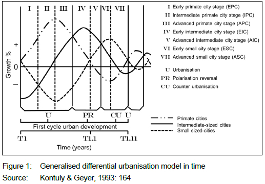
1. Polarisation (or urbanisation), where the population of a core settlement/s (city/cities) grows fastest, and urbanisation is focused on select locations in the urban system. The urban stages described in this phase are the early primate city stage (EPC), where the growth rate of the primary city/cities is greater than small cities, which is greater than intermediate cities, and the advanced primate city stage (APC), where the growth rate of the primate city/cities is greater than intermediate cities, which, in turn, is greater than that of small cities.
2. Polarisation reversal is observed once the growth of core settlements lessens and intermediate cities' populations grow at a higher rate relative to other settlements in an urban system. In turn, the urban stages defined are an early intermediate city stage (EIC), where the growth rates of intermediate cities are greater than the primary city/cities and small cities, and an advanced intermediate city stage (AIC), where the growth rate of intermediate cities is greater than that of small cities, which, in turn, is greater than that of the primary city/cities.
3. The final phase of the urban system cycle, where the urban system reaches maturity, is termed counter-urbanisation. Migration to smaller towns ensures that this category of settlement grows at a higher rate than core settlements and intermediate cities. Like the other phases, the phase is divided into an early small city stage (ESC), where the growth rate of small cities is greater than intermediate cities, which is, in turn, greater than that of the primary city/cities, and an advanced small city stage (ASC), where the growth rate of small cities is greater than that of primary cities, which, in turn, is greater than that of intermediate cities.
The differential urbanisation model functions on the premise of "a cumulative causation process", where one or more primary settlements in a nation state realises "the polarization of labour and any surplus capital from other regions", establishing a core-periphery relationship in an evolving urban system (Geyer, 2003: 89-90). Over time, the primate city/ cities grow to the extent that the conurbation becomes inefficient and costly relative to other regional settlements, due to rising congestion costs and land values, resulting in critical economic activities and associated populations relocating to these more competitive settlements (Kontuly & Geyer, 1993: 159-160). In turn, this causes the growth rates of regional settlements to be greater than the core settlement/s, resulting in polarisation reversal. In turn, improved efficiencies in the urban system, for example improved transit, combined with improved economies of agglomeration in some smaller settlements, realises movement to these places, which grow at higher rates than primary and/or regional cities, and is termed counter-urbanisation (Geyer, 2003: 91-92).
The model assumes that settlements are independent and, by extension, not contiguous (Kontuly & Geyer, 1993: 163). It assumes that the population is employed within respective local economies (Kontuly & Geyer, 1993: 163). Migration is framed as flows that aid concentration, notably the movement of low-income earners to primary cities in search of employment, as well as those flows that aid deconcentration to smaller settlements in the hierarchy, for example middle- and high-income earners moving to rural or small settlements as a lifestyle choice (Geyer, 2003: 97-98). The nature of such migrations varies temporally and spatially.
Kontuly and Geyer (2003: 92) also note that "caution must be exercised when applying the model to reality because the temporal characterization of the differential urbanization model refers to an ideal situation where urban areas are evenly distributed in an area with relatively evenly distributed natural resources". In applying the model to reality, deviations should be anticipated and factored into assessment.
The model has been tested internationally (Kontuly & Geyer, 2003). The studies found that a differential urbanisation cycle is observable, although with variations and discontinuities. Finland was the only country reviewed where polarisation reversal and counter-urbanisation occurred in sequence before the cycle re-initiated with a further phase of polarisation. In Turkey, Italy, and India, the shift from the polarisation stage to the polarisation reversal phase progressed without a counter-urbanisation phase being identified. For Russia and the Federal Republic of Germany, the disruption of the Second World War was used to explain the countries' deviation from the model. When the economic, social, and political disruptions caused by the war ended the crisis-related population deconcentration, the countries entered a polarisation phase (Kontuly & Geyer, 2003).
The studies suggested that, when testing the differential urbanisation model, death and birth rates should be analysed alongside population growth rates, although this was not deemed a necessity (Kontuly & Geyer, 2003). In addition, the possibility of a nationwide assessment being applicable at a regional scale was suggested.
2.2 Differential urbanisation in South Africa
Table 1 captures the experience of settlement change in South Africa, as described by the differential urbanisation model, covering the period 1951 to 2011. Since the 1950s, the urban system has realised two periods where core settlements were identified as growing faster relative to the other two categories of settlement. Two periods, when the intermediate cities were noted to be growing at the fastest rate (1980-1991 and 2007-2011), were arguably a response to decentralisation of economic activity to these centres (either through incentives in the initial period or market dynamics during the second phase) and perceptions of congestion and negative narratives of primate city environments. The single period (1996-2001), when the small settlements of South Africa grew fastest relative to the other settlements, took place during the political transition between the apartheid government and the establishment of a democratically elected state. In this period of administrative change, uncertainty, and limited economic growth, during the HIV/AIDs epidemic, smaller urban centres grew fastest.
From the application of the differential urbanisation model to South Africa, three observations can be made. First, the analysis is dependent on reliable demographic data (Geyer, 2003). During apartheid, Black South Africans were treated primarily as urban migrants and not as residents. This required other means of confirming urban populations. Secondly, the determination of boundaries in the formation of homelands from the late 1960s to the early 1980s meant that the designation of towns and cities, or portions thereof, could change a designation from a core city to a rural location (Geyer, 2003: 95). The vagaries of apartheid planning also highlight that the delimitation of settlements and the subsequent determination of categories is, to an extent, arbitrary and dependent on the perspective of the researcher. This holds in the case of the differential urbanisation model which is applied retrospectively and there is existent knowledge of the growth trajectory of a given settlement, where a three- to four-tier categorisation is optimal to observe relative changes in growth rate, even if a settlement's population size and economic function is not significantly different.
A sub-national application of the model in the South African context has been applied to the primary metropolitan areas (Geyer, 1990; Geyer, 1993; Geyer et al., 2012; Geyer & Roux, 2017; Geyer & Mosidi, 2018). In these studies, population change in conurbations has been differentiated through a range of available socio-economic indicators, including race and income (Geyer, 1990; Geyer, 1993; Geyer et al., 2012), household size (Geyer & Roux, 2017), and gender (Geyer & Mosidi, 2018). These studies add value to the retrospective economic focus of the national application of the differential urbanisation model from a range of socio-economic and cultural perspectives, which may assist in making informed decisions regarding land-use change and infrastructure provision in metropolitan areas.
Besides the metropolitan focus, the application of the differential urbanisation model at a sub-national scale has had limited consideration. An exception is research undertaken by Jacobs (2014), which applied the model in considering in-migration to the Western Cape province between 2001 and 2011, with the focus on the origins and destination of immigrants to the province. Two distinct streams of migrants were identified. A primary stream of migrants came to the province in search of jobs, education, and better services. They were mainly young, low-income earners, aged between 25 and 29 years, originating primarily from the Eastern Cape, settling in the City of Cape Town, Saldanha Bay, George, and Ceres (Jacobs, 2014). A sub-stream of migrants, consisting of relatively affluent, highly skilled, married, and older migrants from the metropolitan cities in the country, especially Gauteng, was also identified. This group was attracted to intermediate sized municipalities such as Overstrand, Mossel Bay, Knysna, and Bitou (Jacobs, 2014). The research was concerned with the nature of urbanisation trends beyond the provincial borders of the Western Cape and did not consider whether the differential urbanisation model was applicable to the province's urban system.
2.3 The application of differential urbanisation to settlement and spatial planning in South African policy
The importance of accurate population projections to facilitate effective settlement planning and public infrastructure provision is acknowledged (Biermann & Landre, 2002: 330). A consideration of population growth has been included in national policy and is a legislated requirement of municipal spatial development frameworks in terms of section 21(e) of the SPLUMA. Therefore, the need for a range of robust population growth perspectives applicable to different geographical scales to understand urbanisation is important for spatial planning in South Africa.
Understanding population change at the settlement level is a key consideration in potential cost modelling for bulk and connector services and social facilities. Population projections guide the capacity demand for infrastructure services for the settlement, and/or a project, influencing density calculations in tandem with a consideration of existing infrastructure supply (and condition) and the settlement units to be provided, or serviced, within budgetary constraints (Biermann & Landre, 2002). In turn, such modelling is underpinned by norms, standards, and guidelines for types of infrastructure and social facilities, providing a level of equity in the provision of services (Wüst, 2020). Such modelling forms the basis of spatial planning, fiscal and capital expenditure strategies, through capital expenditure frameworks in spatial development frameworks, performance management, infrastructure asset management, and infrastructure master planning to achieve set long-term growth and development visions.
Infrastructure planning informs and is informed by provincial and municipal development and spatial plans. The plans' treatment of infrastructure provision references national policy, which, in turn, has evolved over the past three decades in response to project and programme experience in the municipal and provincial spheres of government.
Since 1994, National Spatial policy has linked urbanisation with the provision of infrastructure, basic services, and housing solutions to address the effects of racially segregated settlements under apartheid (RSA, 1997: 3-4; RSA, 2003: 2; RSA, 2006: ii-iii; RSA, 2016: 12; RSA, 2022).
Despite this constant, there have been shifts in how urban policy understands urbanisation within settlements over the past twenty years.
The Urban Development Framework (UDF) (RSA, 1997) did not provide a spatial analysis of settlements in South Africa. Instead, it defined a generic concept uncritical of urbanisation focused on the provision of infrastructure and services for low-income housing.
The National Spatial Development Perspective 2003 (RSA, 2003) was the first post-1994 national planning policy to provide a geographical consideration of urbanisation, dividing South Africa into a well-populated East, and a sparsely populated West. Urbanisation is identified as being focused on coastal cities, Gauteng, and specific regional settlements. These settlements are contrasted with rural areas. Hardly any attempt was made to consider the role of settlements within rural areas and the relationship between settlements across the country. In terms of the differential urbanisation model, the policy applies an undifferentiated polarisation lens to urbanisation. This lens is highlighted in the approach to infrastructure (fixed investment) and urbanisation from the perspective:
"This approach ... seeks to focus the bulk of fixed investment of government on those areas with the potential for sustainable economic development. It can be shown that it is in these areas that the Government's objectives of both promoting economic growth and alleviating poverty will best be achieved. In areas of limited potential, it is recommended that, beyond a level of basic services which all citizens are entitled [to], government should concentrate primarily on social investment such as human resource development, labour market intelligence and social transfers, to give people in these areas better information and opportunities to gravitate towards areas with greater economic potential" (RSA, 2003: 4).
This targeted approach to urbanisation, focused on the metropolitan areas, was diffused in the 2006 update to the National Spatial Development Perspective (NSDP) (RSA, 2006) to emphasise that "Government has a constitutional obligation to provide basic services to all citizens (e.g., water, energy, health and educational facilities) wherever they reside" (RSA, 2006: iii). The revised policy provides the available population, social, economic data, and associated geographical analysis missing in the 2003 version, yet it does not apply this consideration to a consolidated geographical response to urbanisation. In this sense, the 2006 version of the perspective alternated between a polarisation view of urbanisation and an uncritical urbanisation approach in response to the political and departmental demand for blanket service delivery.
In 2011, the National Development Plan (NDP) lay the foundation for subsequent spatial policy in emphasising the monitoring of demographic trends in South Africa and benefiting from the demographic dividend of "a relatively young population" (NPC, 2011: 98). This analysis was applied in relation to the need to transform human settlements in the country (NPC, 2011: 259) through a range of related rural and urban interventions, including a national spatial framework and a national observatory for spatial data assembly and analysis. The plan notes that,
"[a]lthough rural to urban migration is significant, about 78% of migration from rural areas was to other rural areas. Consequently, while the growth of large urban centres needs to be properly managed, planning must also respond to changing pattern of population distribution in rural areas." (NPC, 2011: 105).
The Integrated Urban Development Framework (IUDF) (RSA, 2016) sought to build on the urban proposals of the NDP by "steering urban growth towards a sustainable growth model of compact, connected and coordinated cities and towns" (RSA, 2016: 7). This emphasis on the interrelated, networked nature of nuclear settlement aligns the policy to the differential urbanisation model and its emphasis on the relations of different sized settlements in an urban system. The IUDF notes that settlements differ markedly in South Africa, suggesting that standard theories such as the differential urbanisation model will not necessarily be applicable to all settlements.
Of most significance to the model, the IUDF considers three means of categorising settlement (RSA, 2016: 24-27). One typology is based on the settlement's location in relation to 'the core' and to 'the periphery'. The second uses the SACN/CSIR hierarchy of 'cities', 'large towns', 'small towns', and the 'rest of South Africa'. The third uses a municipal and administrative categorisation drawing on the Municipal Infrastructure Investment Framework Classification and is derived from the Municipal Structures Act, Act 117 of 1998.
The National Spatial Development Framework (NSDF) (RSA, 2022), as envisaged in the NDP, continues to emphasise an interconnected hierarchical urban system considered in the IUDF by "[p]ursuing a denser, smaller, polycentric system of settlements that has (1) a smaller footprint, and (2) spans urban and rural areas; (3) with regard to the nature, function and performance of our Settlements" (RSA, 2022: 89). It rationalises the lUDF's profiling of settlements in recognising four categories of settlement, namely national urban regions, national urban cores, regional development anchors, and rural service centres (RSA, 2022: 152). Population increase is premised on occurring primarily in national urban regions (Gauteng, Western Cape, and eThekwini), due to natural increase and in-migration. The policy concedes that polarisation is not the sole population trend in the country, recognising internal movements from smaller settlements to larger urban areas (national urban cores and regional development anchors). It is tentative on the future growth potential of small towns (rural service centres) indicating that, "while small towns are not expected to see significant population growth, they are not expected to realise significant population decline" (RSA, 2022: 52).
While the NSDF does not recognise the differential urbanisation model specifically, the framework does acknowledge the importance of an urban system and settlement hierarchy and that urbanisation is variable between settlements over time, a key principle of the model (RSA, 2022).
National urban policy has evolved in response to municipal and provincial planning. Through instruments such as integrated development plans and spatial development frameworks in the Municipal Systems Act, Act 32 of 2000, notably section 26, and the SPLUMA, sections 21a-p, municipalities have had to consider the development of a limited portion of the settlement hierarchy without a regional or national perspective. Similarly, a regional perspective of settlements has been provided through the evolution of provincial spatial development frameworks and, more recently, through the advent of regional spatial development frameworks - policy mechanisms legislated for in terms of SPLUMA. This has occurred in tandem with legislation that seeks to realise the financial sustainability of government finances in relation to the complexity of tasks that the organisations perform and the size of population within a given jurisdiction, notably the Public Finance Management Act, Act 1 of 1999; the Municipal Finance Management Act, Act 56 of 2003, and the annual Division of Revenue Act. It is, therefore, unsurprising that national policy has evolved to consider the national urban network and the relationship between settlements of different size and function.
Historically, the differential urbanisation model has been applied primarily at the national and metropolitan levels in South Africa. The idea of an urban system, or hierarchy, on which the model is based, has been incorporated into national policy as concerns
of urban sustainability and the complexity of the jurisdictions under administration have changed in the 20 years between 1996 and 2016. A gap in the consideration of differential urbanisation theory in South Africa is its application to the sub-regional urban system. Such an assessment would provide municipalities and provinces with a more nuanced perspective to urban change than that provided by national policy. The case study below highlights such an attempt, using available data, undertaken for the Western Cape province and the Cape Winelands district municipality.
3. CASE STUDY AREA
The Western Cape province is a coastal province located in the south-west of the Republic of South Africa (Figure 2). The total population of the province was 5.8 million at the last census in 2011 (Stats SA, 2012). The primate or primary city of the province is Cape Town, with an estimated population, in terms of the 2016 Community Survey, of 4.2 million (WCG, 2021a). Medium- or intermediate-sized settlements include Paarl, Wellington, Swellendam, and Plettenberg Bay. Examples of small settlements include Bredasdorp, Laingsburg, and Citrusdal. The Western Cape province has experienced significant population growth over the past 20 years. While this growth has centred on Cape Town, other settlements in the province have also experienced increases in population.
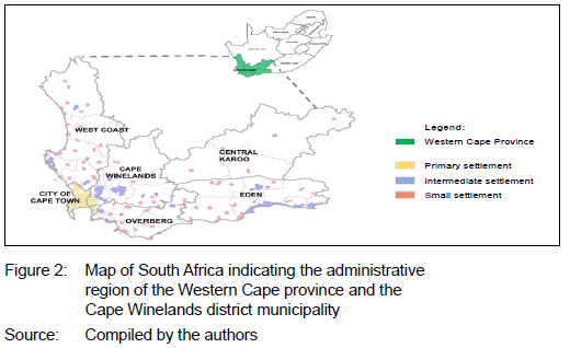
The Cape Winelands district municipality is an administrative jurisdiction in the primary winegrowing area of the Western Cape (Figure 2). Key settlements in the district municipality include Stellenbosch, Paarl, and Worcester. The jurisdiction was chosen as a case study, due to the fact that it is the most populous district municipality outside of the City of Cape Town and that significant growth has occurred in its major urban centres, in part due to its proximity to the primate city, but also in terms of the desirability of the region as a place to live and work.
This case study draws on urbanisation and migration research undertaken by the Western Cape Government's Department of Environmental Affairs and Development Planning (DEA&DP). The application of the differential urbanisation model to the Western Cape province included 94 settlements (see Annexure 1). The sample was, in turn, used to analyse settlement relationships for the Cape Winelands district municipality.
4. METHODOLOGY
4.1 Research questions
The following research questions were used to guide the study:
• Is the differential urbanisation model applicable to the Western Cape?
• What are the sub-national conditions under which the model might fail?
• How might spatial planning benefit from a consideration of the model?
4.2 Research design
The study made use of a descriptive research methodology to gather, analyse, and present quantitative data on population growth. The research provided insights into the urbanisation trends within the Western Cape province during the study period 1996 to 2016. Descriptive research is useful in understanding how, when, and where the model occurs and its associated patterns in the Western Cape. The findings of this descriptive research create scope for further detailed research to understand where (for example, migration trends, settlement hierarchy, and so forth) and why the differential urbanisation model may be applicable.
4.3 Data collection
The spatial distribution of population groups was considered, by analysing changes in population size in Western Cape settlements, using Statistics South Africa Census data for the years 1996 (Stats SA, 1997), 2001 (Stats SA, 2002),
and 2011 (Stats SA, 2012). In addition, the 2016 Stats SA National Community Survey data (Stats SA, 2016) was also used. Stats SA population figures for settlements were extracted from the CSRI's MesoZone 2018v1 Dataset (CSIR, 2018), where population data sets are assigned to mesozones based on an algorithm developed on the principles of dasymetric mapping. Stats SA 1996, 2001, 2011, and 2016 population figures were used as the input data for the respective years. These data sets have different spatial demarcations. The data has thus been re-aligned to the mesozones to create a comparable data set, using the secondary data (Van Huyssteen et al., 2018).
4.4 Calculations
The population growth rates for each of the settlements that fall within the primary, intermediate, and small settlement categories were calculated. The following calculations were used to determine the percentage change between the census years (for example, between 1996 and 2016), and average growth rate (%) per annum:
Percentage change = (2016 population final value - 1996 population starting value)/1996 population starting value
Average annual rate of growth (%) = percentage change/time (years)
Once the population growth rates of the three settlement categories were determined, the differential urbanisation model was applied to determine the recurring sequence (see Table 4).
4.5 Settlement classification
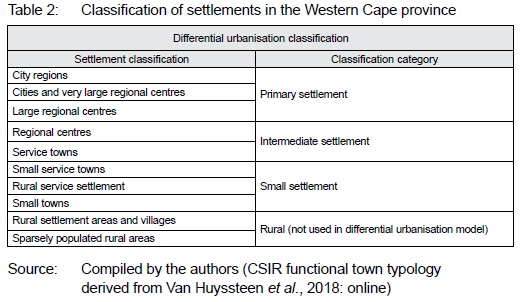
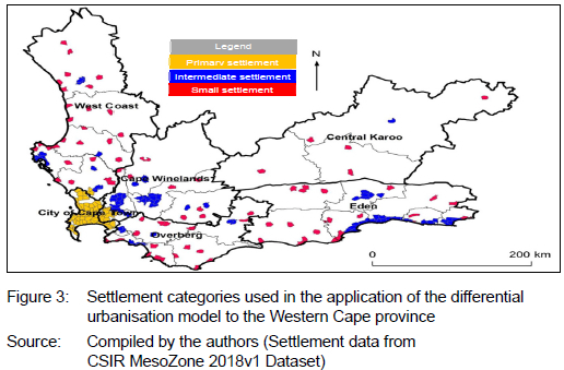
According to the differential urbanisation model, settlements are classified as either primary, intermediate, or small settlements. However, the model does not give guidance in defining these settlement typologies. To this end, the study used a modification of the 2018 CSIR functional town typology to classify settlements in the Western Cape. Although the 2018 CSIR functional town classification system has 10 types, these have been translated into three settlement categories to simplify analysis and align with the common tri-class form of the differential urbanisation model, and to the settlement categorisation used by the IUDF (RSA, 2016). The interpretation of the CSIR functional town classification system is captured in Table 2. Figure 3 depicts a map showing the spatial distribution of the subsequent classification of settlements.
4.6 Sample
Table 3 is an extract from the Excel document that was used in the study to list all settlements in the Western Cape, their classification, their population figures for 1996, 2001, 20 11, a nd 201 6, as well as the calculated ave rage annual rate of growth between census periods (see Annexure A for a complete list).
4.7 Data analysis
In calculating the growth rate for the settlements in the three categories, the following information will be analysed:
Pattern:
The three settlement categories will be classified as either urbanisation (U), polarisation reversal (PR), or counter-urbanisation (CU) for the respective years, according to the differential urbanisation model.
Urban stage:
The three settlement categories will be classified as either early or advanced for the respective years, according to the differential urbanisation model.
Urban development cycle:
According to the differential urbanisation model, counter-urbanisation represents the final phase in the first cycle of urban development and is followed by a se cond cycle in which urbanisation dominates once again.
4.8 Limitations
There are inherent limitations in undertaking such a study, due to data and the nature of the model being assessed.
First, the study makes use of available census and community survey data for 1996, 2001, 2011, and 2016. The 2007 community survey was excluded, due to concerns related to its credibility (Mail and Guardian, 2008) and small sample size, which made disaggregation of the data difficult.
Secondly, due to a decade-long period between censuses, the latest data for the 2016 community survey is outdated and based on a relatively small sample, and the 2022 census data is yet to be analysed. As a result, there is uncertainty regarding the quality of the recent data used and as such, the assumptions made based on this information.
Thirdly, population figures for settlements were extracted from the SA CSIR MesoZone 2018v1 Dataset, where STATS SA's 1996, 2001, 2011, and 2016 population figures were re-aligned to mesozones to create a comparable data set. As a result, the population figures used in the study are not identical to the census figures (which are ward based), but the data is spatially comparable, ensuring that data can be applied satisfactorily for the purpose of the current analysis.
Fourthly, the growth rate calculations should ideally incorporate births and deaths at the settlement level. However, in some of the national case studies applying the model, only population growth rate was used in the analysis, and this was considered adequate in the literature (Kontuly & Geyer, 2003). Similarly, the study could have used other data such as economic growth, unemployment, ethnicity, and income distribution to obtain a more detailed perspective on the nature of differential urbanisation in the Western Cape.
Fifthly, the differential urbanisation model is a theoretical application, based on assumptions regarding the economy and the nature of settlements. The reality of the study is that, in some cases, settlements were contiguous (where settlements in the City of Cape Town merge with settlements in the Cape Winelands district), that the majority employed did not necessarily work within the catchment of the settlement, due to commuting and the influence of the internet economy, and that settlements and resources were not evenly located across the province. As such, deviation from the model in the study should be expected.
Lastly, the analysis carried out in relation to the case studies is an extrapolation, based on a reading of available data. Other analyses of settlement population using different spatial definitions, settlement footprints, or population estimates (for example, mid-year population estimates) may realise different interpretations of the differential urbanisation model as it applies to the Western Cape and to the Cape Winelands district municipality. Further analysis and discussion are required to understand different interpretations of settlement trends.
5. FINDINGS
5.1 Western Cape
The change in growth rates between the three categories of settlement was calculated for the settlements in the Western Cape province (see Table 5). While populations continued to grow in the settlements in the Western Cape, the rate of population growth declined for all three categories between 1996 and 2016.
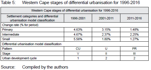
In comparing the settlement categories, the greatest change in growth rates for the period 1996 to 2016 was experienced in the small settlements (4.29%). This is expected, given the larger number of settlements and the smaller population sizes in the small settlement category relative to the other categories. Relatively small changes in population size will have a greater statistical impact in the small settlement category than in the other categories. It is interesting to note that the primary settlement (namely, the Cape Town Metro) had a higher growth rate for the period relative to the intermediate settlements, a reflection of the urban centre's importance as a locus of urbanisation in the province.
Figure 4 graphically represents the relationship between the growth rates of the Western Cape settlement categories, as an interpretation of the province's differential urbanisation narrative.
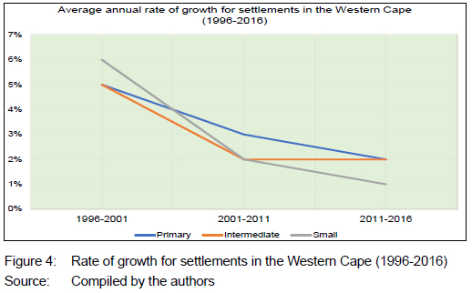
Between 1996 and 2001, the Western Cape urban system experienced a counter-urbanisation phase, where the rate of growth of small settlements (5.56%) was higher than that of the primary (4.63%) and intermediate settlements (4.67%). During this period, intermediate settlements had a higher growth rate than the primary settlements, which classifies the urban system during the period as being in the early small city stage (Phase V).
From 2001 to 2011, the Western Cape urban system went through an urbanisation phase, where the growth of primary settlement was higher than the intermediate (2.37%) and small settlement (1.80%) categories. As the intermediate settlements showed higher growth rates than the small settlements, the urban system is identified as being in an advanced large city stage (Phase II) during the period.
From 2011 to 2016, the Western Cape urban system experienced polarisation reversal, where the rate of growth of intermediate settlements (2.25%) was higher than that of primary (1.48%) and small settlements (1.27%). Primary settlements realised a marginally higher growth rate than small settlements, placing the Western Cape urban system in the early intermediate city (III) stage. In terms of the differential urbanisation model, the stage marks a turning point in the spatial patterns of growth and development, as continuing concentration ceases and urban deconcentration from primary settlements commences.
If the differential urbanisation model holds, it is expected that, post-2016, the Western Cape will have moved into a counter-urbanisation phase again. This shift will be confirmed once the census 2022 data is available.
When comparing the provincial findings with the national application of the differential urbanisation model undertaken by Geyer and Geyer (2015), the phases experienced are the same for the 1996-2001 and the 2001-2007 periods. However, for the 2007-2011 period, the national urban system experienced polarisation reversal, while, in terms of the provincial case study, the polarisation reversal was identified later in the period 2011-2016.
5.2 Cape Winelands district municipality
The differential urbanisation model was tested, using the three settlement categories for the Cape Winelands district municipality, including Stellenbosch, Drakenstein, Witzenberg, Breede Valley, and Langeberg local municipalities.
The 'primary' settlement category includes Stellenbosch and settlements contiguous to the Cape Town metropolitan area, which fall within the Cape Winelands district's jurisdiction. Settlements categorised as 'intermediate' included Paarl/ Wellington (as an amalgamated settlement), Ceres, Worcester, and Robertson. Settlements categorised as 'small' included Saron, Tulbagh, De Doorns, and McGregor.
During 1996-2016, the rate of growth of the primary settlement was constant, averaging between 2.14% and 2.40%. The rate of growth of intermediate, and especially small settlements, was highly variable (see Table 6 and Figure 5). Between 2011 and 2016, the growth rates of all three categories of settlement converged in a band between 2.31% and 2.48% (see Figure 5).
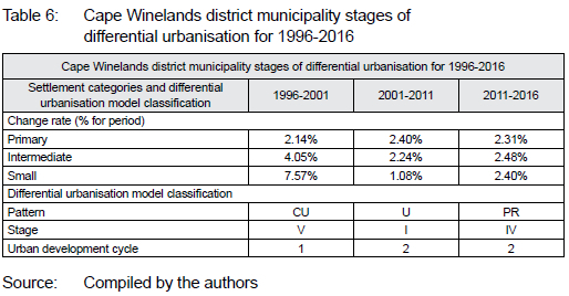
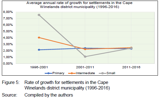
The Cape Winelands district municipality mirrored the phases and stages realised by the analysis at the provincial scale. Between 1996 and 2001, counter-urbanisation was experienced; between 2001 and 2011, polarisation, and between 2011 and 2016, polarisation reversal.
Between 2011 and 2016, intermediate settlements such as Wolseley (2.87%), Ceres, Franschhoek (2.78%), and Robertson (2.56%) experienced the highest growth rates in the category. Yet, some individual small settlements experienced even higher growth rates than these intermediate settlements such as in Tulbagh (3.20%), McGregor (2.49%), and De Doorns (2.27%).
6. DISCUSSION
6.1 Differential urbanisation model
Despite the expectation for deviation from the differential urbanisation model, when applied to Western Cape province and the Cape Winelands district municipality, the model held true. The hierarchy of settlements chosen demonstrated cyclical shifts in population growth rates for the two sub-national regions. This indicates that the urban system grew at differing and predictable rates over a two-decade period, realising periods of attraction and dispersal relative to the primary settlement, Cape Town.
As of the 2011-2016 period, the Western Cape and the Cape Winelands district urban systems are maturing, with primary cities experiencing declining growth rates, whereas intermediate cities experience higher growth rates.
Where deviation did occur, it was in relation to the application of the differential urbanisation model to the national urban system, where polarisation reversal was observed in a later period at the provincial and district municipality levels, than that experienced at the national scale. This misalignment could be a function of the study being unable to apply the STATS SA community survey data, but it could also be an indication of an urbanisation pattern specific to the Western Cape. If the sample for the Western Cape is valid, Census 2022 data will be required to verify this deviation.
A reason for the Western Cape urban settlement alignment to the differential urbanisation model is that it should meet the underlying assumption of the model that the economies of the settlements in question were growing during the period. While this may have been the case in some periods for specific settlements in the province (for example, Cape Town, Stellenbosch, Paarl), low to negative economic growth was experienced for other periods in specific settlements (WCG, 2021b). It could also be that shifts in economic activity to greater informalisation and an increase in information technology-based enterprise may be distorting settlement growth patterns. In the case of the informal economy, this could mean that the settlements' economy is growing faster than predicted but was not reported. In terms of the model, this would realise greater settlement growth of low-income housing and informal settlement. The impact of informalisation is arguably most visible in smaller settlements such as De Doorns and Tulbagh, where the formal economies of the towns and hinterlands do not support the populations residing in these towns. In relation to technology-based enterprise, employment may be based elsewhere, nationally or overseas, and may have limited physical connection to the settlement in which the labour is undertaken, an underlying assumption of the urban differential model, so that while economic activity, and perhaps growth may occur, this does not necessarily realise change in settlement populations. This may have a disproportionate impact on the increase in settlement form through a growth in lifestyle estates premised on high levels of internet connectivity and increased security.
A further possibility for the application of the differential urbanisation model is the movement of middle-income and wealthy groups to select locations in the Western Cape (for example, Hermanus, Stellenbosch, Paarl, and McGregor) as a lifestyle choice, a population flow identified by Jacobs (2014).
The application of the model to the study areas may simply reflect a distinctive regional urban system of largely independent centres that, due to historical and topographical reasons, are relatively evenly distributed, and, while not evenly resourced, are physically well connected. However, the above possibilities are speculative and require further research.
The study highlights the impact of relatively small increases in population on small towns. This dictates an increase in the population growth rate for that tier in the settlement hierarchy within a given period. This creates a generalisation as to the nature of population change in this settlement type across the geographical area. While models are premised on such generalisations, it is important to reflect on why given outcomes are observed. The observation also highlights the importance of rational determination and explanation in defining a settlement hierarchy's categories.
The above argument assumes that the application of the differential urbanisation model in the case of the Western Cape province and the Cape Winelands district municipality is unusual, and that its realisation could be disrupted by a range of factors, including crime in primary settlements; the residual negative effects of the COVID pandemic; impacts of interest rate shifts and other housing market dynamics; reduction in tourism; increases in unemployment; political instability, and financial constraints in the public and private sectors.
6.2 The differential urbanisation model and planning
Differential urbanisation as a retrospective economic geographic model is not a planning tool. Nevertheless, as the model applies to the study areas, it can be used to identify settlements that have populations growing faster than others. This can be used as an indicator of settlements that require additional capital investment relative to existing infrastructure and facility capacity. This would have a significant impact on rural settlements that may be experiencing unexpected in-migration not considered in sector masterplans, infrastructure asset management plans, and small capital budget allocations from national and provincial government. Annual, medium- and long-term budgets would need to be sensitised to these variations in settlement growth rates and the implication for budget spending, especially with regard to infrastructure that supports economic growth: water, electricity, transport, and local economic development support.
From a spatial (or strategic) planning perspective, the cyclical, urban systems focus of the differential urbanisation model has offered a more complex view of settlement than national urban policy applied prior to 2016. This policy focused on nationwide service delivery to address apartheid settlement segregation, with investment focused on primary metropolitan areas at the expense of relative economic growth in rural settlements. Since the introduction of the IUDF and the subsequent NSDF, policy has considered an urban system approach that emphasises the relational and hierarchical aspects of settlement. While these policies do not apply the differential urbanisation model, they do create a scenario where applying the model may be useful in applicable geographies.
The study suggests that, given the success of applying the model at the provincial and district municipal levels in the Western Cape, district and metropolitan spatial planning initiatives such as the joint district and metropolitan approach (the local version of the national district development model), as well as district and provincial spatial developments would be suitable vehicles to incorporate the differential urbanisation model. This would contribute to historical attempts within municipalities and provinces to understand local settlement dynamics.
7. CONCLUSIONS AND RECOMMENDATIONS
This study sought to apply the differential urbanisation model to the provincial and district municipality contexts of the Western Cape between 1996 and 2016, expanding past applications to the national and metropolitan urban systems. The study found that the model applies to the province and the case of the Cape Winelands district municipality.
The study highlighted that urbanisation within the Western Cape province occurs in the context of a long-term declining population growth rate across settlements. Placed in a hierarchy of primary, intermediate and small settlements, population growth rates for these categories follow a cyclical process of concentration and deconcentration relative to the other categories. These processes can be termed polarisation, polarisation reversal, and counter-polarisation.
While the differential urbanisation model is not a planning tool, it provides a means of assessing which settlements require additional capital funding for services and facilities, in order to meet the needs of settlements with unexpected increases in population. This would be especially useful for smaller municipalities that have limited capital budgets. The model could best inform the revision of district and provincial spatial development frameworks.
In applying the differential urbanisation model in other provinces and districts, practitioners would need to ascertain whether the model would apply, as urban systems vary across South Africa (Geyer, 2003; RSA, 2022) and may differ from the Western Cape experience.
Further study is required to understand the development trends identified in this study, particularly in relation to the impact of population change in individual small towns and intermediate settlements. This study should be updated once Census 2022 information becomes available.
More recent studies applying the differential urbanisation model to metropolitan areas (Geyer et al., 2012; Geyer & Roux, 2017; Geyer & Mosidi, 2018) indicated that using different criteria in tandem with a consideration of population growth rates can provide useful insight into settlement growth, and by extension the provision of infrastructure and settlements. Criteria that would be useful in terms of infrastructure provision in each settlement would include employment, income, gender, poverty, municipal rates, relative conditions of infrastructure networks and services, as well as indicators of local economic growth.
REFERENCES
BIERMANN, S. & LANDRE, M. 2002. The utilisation of engineering service bulk infrastructure component in integrated development planning. Development Southern Africa, 19(2), pp. 329-355. https://doi.org/10.1080/03768350220132512 [ Links ]
CSIR (COUNCIL FOR SCIENTIFIC AND INDUSTRIAL RESEARCH). 2018. MesoZone 2018v1 Dataset. Pretoria: CSIR. [ Links ]
FAIR, T.J.D. 1982. South Africa: Spatial frameworks for development. South African Geography and Environmental Studies Series. Chapter 2. Cape Town: Juta & Co. [ Links ]
GEYER, H.S. 1990. Implications of differential urbanization on deconcentration in the Pretoria-Witwatersrand-Vaal Triangle metropolitan area, South Africa. Geoforum, 21(4), pp. 385-396. https://doi.org/10.1016/0016-7185(90)90019-3 [ Links ]
GEYER, H.S. 1993. Africanurbanisation in metropolitan South Africa. Geojournal, 30(3), pp. 301-308. https://doi.org/10.1007/BF00806721 [ Links ]
GEYER, H.S. 2003. Differential urbanisation in South Africa - A further exploration. Tijdschrift voor Economische en Sociale Geografie, 94(1), pp. 90-100. https://doi.org/10.1111/1467-9663.00239 [ Links ]
GEYER, H.S. & GEYER, H. 2015. Disaggregated population migration trends in South Africa between 1996 and 2011: A differential urbanisation approach. Urban Forum, 26(1), pp. 1-13. https://doi.org/10.1007/s12132-014-9229-1 [ Links ]
GEYER, H.S. & ROUX, S.G. 2017. Demographic transitions in South African cities: An analysis of household structures in the City of Tshwane. Regional Science: Policy and Practice, 9(3), pp. 165-181. https://doi.org/10.1111/rsp3.12103 [ Links ]
GEYER, H.S. & MOSIDI, N. 2018. Differential demographic transitions for women of different ethnicities in Gauteng, South Africa, 1996-2011. Regional Science Policy and Practice, 11(1), pp. 159-171. https://doi.org/10.1111/rsp3.12171 [ Links ]
GEYER, H.S., GEYER, H.S. (JUNIOR), DU PLESSIS, D. & VAN EEDEN, A. 2012. Differential urbanisation trends in South Africa - Regional and local equivalents. Environment and Planning A: Economy and Space, 44(12), pp. 2940-2956. https://doi.org/10.1068/a4528 [ Links ]
JACOBS, W. 2014. Migration patterns and migrant characteristics in the Western Cape through a differential urbanisation lens. Mini-thesis presented in partial fulfilment of the requirements for the degree of MPhil Urban and Regional Science in the Faculty of Arts at Stellenbosch University. [Online]. Available at: <http://scholar.sun.ac.za/handle/10019.1/95728> [Accessed: 21 September 2022]. [ Links ]
KONTULY, T. & GEYER, H. 1993. A theoretical foundation for the concept of differential urbanization. International Regional Science Review, 15(2), pp. 157-177. https://doi.org/10.1177/016001769301500202 [ Links ]
KONTULY, T. & GEYER, H. 2003. Lessons learned from testing the differential urbanization model. Tijdschrift voor Economische en Sociale Geografie, 94(1), pp. 124-128. https://doi.org/10.1111/1467-9663.00242 [ Links ]
MAIL AND GUARDIAN. 2008. State survey said to be unreliable by staff reporter. [Online]. Available at: <https://mg.co.za/article/2008-01-08-state-survey-said-to-be-unreliable> [Accessed: 21 September 2022]. [ Links ]
MOOKHERJEE, D. & GEYER, M. 2011. Urban growth in the national capital region of India: Testing the differential urbanisation model. Tijdschrift voor Economische en Sociale Geografie, 102(1), pp. 88-99. https://doi.org/10.1111/j.1467-9663.2010.00599.x [ Links ]
NPC (NATIONAL PLANNING COMMISSION). 2011. National Development Plan 2030: Our future, make it work. Pretoria: The Presidency RSA (REPUBLIC OF SOUTH AFRICA). 1997. Urban development framework. The Department of Housing. Pretoria. [Online]. Available at: <https://www.gov.za/sites/default/files/gcis_document/201409/saurb.pdf> [Accessed: 17 June 2022]. [ Links ]
RSA (REPUBLIC OF SOUTH AFRICA). 2003. National spatial development perspective. The Presidency. Pretoria. [Online]. Available at: <http://toolkit.cidb.org.za/Shared%20Documents/PG1-S03%20National%20Spatial%20Development%20Perspective%202003-03.pdf.> [Accessed: 20 September 2022]. [ Links ]
RSA (REPUBLIC OF SOUTH AFRICA). 2006. National spatial development perspective. The Presidency. Pretoria. [Online]. Available at: <https://www.gov.za/sites/default/flles/gcis_document/201409/complete1.pdf> [Accessed: 20 September 2022]. [ Links ]
RSA (REPUBLIC OF SOUTH AFRICA). 2016. Integrated urban development framework. Department of Cooperative Governance. Pretoria. [Online]. Available at: <https://iudf.co.za/knowledge-hub/documents/> [Accessed: 30 September 2022]. [ Links ]
RSA (REPUBLIC OF SOUTH AFRICA). 2018. Cities infrastructure delivery management system (CIDMS) Toolkit Edition 1. Section 1.4: Emerging urban policy and implications for infrastructure planning and delivery. [Online]. Available at: <https://cidms.co.za/modules/CIDMS%20Toolkit.pdf.> [Accessed: 15 June 2022]. [ Links ]
RSA (REPUBLIC OF SOUTH AFRICA). 2022. National spatial development framework: April 2022. Department of Planning, Monitoring and Evaluation. Pretoria: RSA. [ Links ]
SACN (SOUTH AFRICAN CITIES NETWORK). 2016. State of South African Cities Report 2016. Johannesburg. [Online]. Available at: <https://www.sacities.net/the-state-of-south-african-cities-report-2016/> [Accessed: 20 September 2022]. [ Links ]
STATS SA (STATISTICS SOUTH AFRICA). 1997. South African Census 1997 [Dataset]. Statistical Release. Pretoria: Stats SA. [ Links ]
STATS SA (STATISTICS SOUTH AFRICA). 2002. South African Census 2001 [Dataset]. Statistical Release. Pretoria: Stats SA. [ Links ]
STATS SA (STATISTICS SOUTH AFRICA). 2012. South African Census 2011 [Dataset]. Statistical Release. Pretoria: Stats SA. [ Links ]
STATS SA (STATISTICS SOUTH AFRICA). 2016. Community Survey 2016. Pretoria: Stats SA. [ Links ]
VAN HUYSSTEEN, E., GREEN, C., SOGONI, Z., MARITZ, J. & MCKELLY, D. 2018. South African functional town typology (CSIR 2018 v2). [Online]. Available at: <http://stepsa.org/socio_econ.html#Indicator> [Accessed: 20 September 2022]. [ Links ]
WCG (WESTERN CAPE GOVERNMENT). 2021a. Differential urbanisation within the Western Cape between 1996 and 2016: March 2021. Western Cape Government: Department of Environmental Affairs and Development Planning. Internal research paper. Cape Town: WCG. [ Links ]
WCG (WESTERN CAPE GOVERNMENT). 2021b. Municipal economic review and outlook (MERO). Provincial Treasury. Cape Town. [Online]. Available at: <https://www.westerncape.gov.za/provincial-treasury/files/atoms/files/4.%202021%20MERO%20final.pdf> [Accessed: 20 September 2022]. [ Links ]
WÜST, F. 2020. Background paper in respect of approaches to infrastructure planning, prioritisation and the importance of settlement data in the Western Cape Government: An input based on a personal reflection. Unpublished report produced for the Western Cape Government. [ Links ]
Received: September 2022
Peer reviewed and revised: January 2023
Published: June 2023
* The author(s) declared no potential conflicts of interest with respect to the research, authorship, and/or publication of this article


