


Services on Demand
Article
 English (pdf)
 Article in xml format
 Article references
Indicators

Related links
-
 Cited by Google
 -
 Similars in Google
Share

 Permalink
Town and Regional Planning
On-line version ISSN 2415-0495
Print version ISSN 1012-280X
Town reg. plan. (Online) vol.82 Bloemfontein 2023
http://dx.doi.org/10.18820/TRP.V82I.7116
REVIEW ARTICLE
A review of some of the criteria used in land-demarcation processes
'N oorsig van sommige kriteria wat in grondafbakeningsprosesse gebruik word
Tlhahlobo ea e meng ea mekhoa e sebelisoang ho arola meeli ea lefats'e
Zaakirah JeevaI; Juanee CilliersII; Trynos GumboIII
IUnit for Environmental Sciences and Management, North-West University, Potchefstroom, South Africa. Phone: 0725702956, email: Zaakirah.Jeeva@gmail.com, ORCID: https://orcid.org/0000-0001-5327-859X
IISchool of Built Environment, University of Technology, Sydney, Australia. Email: Juanee.cilliers@uts.edu.au, ORCID: https://orcid.org/0000-0002-8581-6302
IIIDepartment of Urban and Regional Planning, University of Johannesburg, South Africa. Phone: +27 (0)11 559 6062, email: tgumbo@uj.ac.za, ORCID: https://orcid.org/0000-0003-3617-4996
ABSTRACT
In recent years, settlements have sprawled beyond the urban growth boundaries, due to a number of factors, including mobility, technology, and urban blight. As a result, governments globally have opted to restructure their local administrative boundaries (municipalities) to be more accommodating to the unplanned growth, while setting a clear limit to the extent to which the urban region could grow. Without a clear administrative boundary, urban problems such as civil conflict, administrative duplication, political corruption, lack of service delivery, and environmental degradation become more prevalent. In order to understand the driving forces behind administrative delimitation, this article reviews how local administrative boundaries can be delineated from a theoretical stance. It further unpacks various criteria to contextualise how boundaries could be demarcated and their resultant structure. The article reveals that, from a theoretical stance, the method of demarcating administrative urban boundaries is not apparent, since a variety of factors influence open systems. Consequently, this article provides awareness of the challenges of demarcating local administrative boundaries, with both administrative and policy implications. Administratively, it sheds light on criteria that can influence boundary demarcation. In terms of policy, it demonstrates that the demarcation of boundaries is a huge challenge that requires further research and action.
Keywords: local administration, demarcation, local boundaries, functional linkages
OPSOMMING
Nedersettings het die afgelope jare buite die stedelike groeigrense uitgebrei, as gevolg van 'n aantal faktore, insluitende mobiliteit, tegnologie en die verval van stedelike areas. Gevolglik het regerings regoor die wêreld begin om hul plaaslike administratiewe grense (munisipaliteite) te herstruktureer om meer tegemoetkomend te wees vir die onbeplande groei, maar terselfdertyd 'n duidelike beperking te stel tot die mate waarbinne die totale stedelike streek kan groei, want sonder 'n duidelike administratiewe grens word stedelike probleme soos burgerlike konflik, administratiewe duplisering, politieke korrupsie, gebrek aan dienslewering en omgewingsagteruitgang meer algemeen. Ten einde die dryfkragte agter administratiewe afbakening te verstaan, poog hierdie artikel om te verstaan hoe plaaslike administratiewe grense vanuit 'n teoretiese standpunt afgebaken kan word. Die wetgewende kriteria word verder ontleed en die teoretiese rasionaal van afbakening word gekontekstualiseer. Die artikel het bevind dat vanuit 'n teoretiese standpunt die metodes om administratiewe stedelike grense af te baken nie duidelik is nie, aangesien dit oop sisteme is wat deur 'n verskeidenheid faktore beïnvloed word. Gevolglik beklemtoon hierdie artikel die uitdagings van toepassing op die afbakening van plaaslike administratiewe grense, wat beide administratiewe en beleid-implikasies inhou. Administratief werp dit lig op kriteria wat grensafbakening kan beïnvloed en in terme van beleid demonstreer dit dat die afbakening van grense uitdagend is en verdere navorsing verg.
KAKARETSO
Lilemong tsa morao tjena, libaka tsa bolulo li nametse ka ng'ane ho meeli ea kholo ea litoropo, ele litla-morao tsa mabaka a 'maloa, a kenyelelitseng ho falla, theknoloji le ho senyeha ha metse litoropong. Ka lebaka leo, mebuso lefatseng ka bophara e khethile ho hlophisa bocha meeli ea eona ea tsamaiso ea lehae (masepala) hore e lumellane le kholo e sa reroang, ha e ntse e beha moeli o hlakileng oa hore na tikoloho ea litoropo e ka hola hakae. Ntle le moeli o hlakileng oa tsamaiso, mathata a litoropong a kang likhohlano tsa sechaba, phetiso ea tsamaiso, bobolu ba lipolotiki, khaello ea phano ea litsebeletso, le ho senyeha ha tikoloho li tsoa taolong. E le ho utloisisa matla a susumetsang karolo ea meeli ea tsamaiso, sengoloa sena se hlahloba hore na meeli ea tsamaiso ea lehae e ka hlalosoa joang ho latela maikutlo a khopolo-taba. E tsoela pele ho manolla mekhoa e fapaneng ea ho hlalosa hore na meeli e ka aroloa joang le sebopeho sa eona. Sengoliloeng se senola hore, ho latela maikutlo a khopolo-taba, mokhoa oa ho beha meeli ea tsamaiso ea litoropo ha o bonahale, kaha lintlha tse fapaneng li susumetsa litsamaiso tse se nang taolo. Qetllong, sengoloa sena se fana ka tlhokomeliso ea liqholotso tsa ho arola meeli ea tsamaiso ea lehae, ka litlamorao tsa tsamaiso le maano. Tsamaisong, sengoloa se fana ka leseli holim'a mekhoa e ka susumetsang ho seha meeli. Mabapi le maano, se bontsa hore ho seha meeli ke phephetso e kholo e hlokang lipatlisiso le mehato e meng e tla fokotsa litla-morao.
1. INTRODUCTION
Human beings have a need to name and categorise objects, concepts, and places to make sense of their surroundings, in order for them to function more efficiently (Fulkerson, Waxman & Seymour, n.d.:1). Politicians alike demarcate their territory into smaller administrative regions such as electoral wards, municipalities, districts, and provinces, in order to manage civil administration and provide a platform for the redistribution of resources. It is anticipated that subdivision provides insight into regional disparities and assists government in their long-term plans of promoting spatial equality, economic efficiency, sustainability, and social cohesiveness at various levels within a country (Feleke, 2018: 130; Zhou et al., 2016: 1). For the purposes of this article, only the method of demarcating municipalities (basic administrative boundaries), which are the lowest tier of local government, is analysed, and not ward and district boundaries (Drupal, 2021).
Historically, the categorisation of local administrations was based on the economic activities within the regions and they were delimited as either 'urban' or 'rural' areas. From a town-planning perspective, urban administrative regions included cities and towns, while rural areas encompassed villages and hamlets (UN, 2012: 4). However, the interdependent relationship between these administrative regions has resulted in many expanding beyond their delimited boundaries, thus challenging the administrative management of the area (Zhou et al., 2016: 1).
According to Zhang (2016: 1), urban sprawl occurs due to three reasons, namely natural population growth, urbanisation, and decentralisation. Natural population growth is when the birth rate in the region exceeds the death rate and settlements grow naturally beyond their boundaries, transforming villages to towns; urbanisation is rapid development caused by the in-migration of individuals from rural areas into urban areas transforming towns to cities, and decentralisation is the movement of individuals out of urban areas into the peripheral rural areas, transforming cities into metropolitan regions, conurbations, or polycentric regions (Sporna & Krzysztofik, 2020: 2). The latter (regions) are larger than the traditional settlements, as they are created through the interdependent functional relationship between settlements (Vasanen, 2012: 1; SinclairSmith, 2015: 132). The functional region is more abstract than the traditionally, demographically, and economically classified administrative settlement, in that it encompasses the functional linkages of various communities between where they live, work, shop, access healthcare, and recreate (Vasanen 2012: 2; Ramutsindela, 2013: 42). Friedmann (1978) suggests that the growth and development of the functional region should be contained through the delimitation of a formal administrative boundary. In this way, he hoped to contain sprawl through compact development.
However, Bennet (1989) has an alternative view. He believes that the administrative boundary should be extended to coincide with the functional boundary. In his opinion, one cannot restrict sprawl. The extension of the administrative boundary to incorporate many functionally related settlements would allow for the more efficient administrative management of the region as an entity. However, the functional region cannot be easily noticed and it could include a number of demographically categorised settlements and peri-urban zones, which can extend as far as 300 km (Webster & Muller, 2004: 282).
This raises the question: How should sprawling settlements be contained via local government administrative boundaries?
2. METHODS AND REVIEW APPROACH
This review seeks to explore the criteria that guide the delimitation of boundaries and how it is implemented in municipal formation. First, the delimitation of boundaries was reviewed to provide insights into the current state of administrative boundaries. Secondly, the different administrative delimitation rationales were introduced and reviewed from an urban planning perspective to motivate the criterion for local municipal boundaries and their different outcomes.
A qualitative research approach was employed primarily through the application of desktop research. Relevant materials used in this review consisted of articles, theses, reports, and other documents obtained from the North-West University library database and the internet. As an initial search, relevant documents were identified through the application of a database keyword search for terms associated with the delimitation of local administrative boundaries, delimitation of municipalities, demarcation of boundaries, motivation for spatial structural reform, categorisation of municipalities, and local boundaries formation. The primary search was performed between 13 May 2020 and 15 December 2020, with supplementary supporting information sourced between 2 February 2021 and 29 February 2022. Preference was given to more recent literature to reflect on current research on, and approaches to the topic. To expand on the relevant literature for review, several of the references cited in the initial texts were also evaluated for their relevance to this topic. Rather recent research has been conducted on the delimitation of these municipal regions. Currently, limited comprehensive studies can be referenced on the criteria and the effects of local boundary extension and settlement incorporation (Zhou et al., 2016: 2; Feleke, 2018: 152). The initial search for relevant academic material on the delimitation of local boundaries found that most of the studies focused on the technical methodology of how boundaries can be delimited and the relevant outcomes. This may be because there is no standard way of delimiting boundaries globally and the outcome of the various methods brings forth different structures. Consequently, research output on the criteria is scarce.
Due to the rareness of relevant literature, and the exploratory and evaluative nature of the present research endeavour, the review relied heavily on grey literature. This documentation primarily consists of reports and policy documents from both governmental and nongovernmental agencies, which were identified and sourced either through internet search terms, or because they were referenced or referred to in the referenced journal articles. It is important to note that this review utilises sources with varying degrees of credibility, and this may influence the final accuracy and validity of the discussion. Furthermore, the examples discussed were chosen on the basis that information was easy to access. Thus, educated assumptions had to be made regarding which data to use.
The review approach included a thematic analysis to identify criteria used to delimit local boundaries. Subsequently, the main criterion identified from the literature review was coded and grouped into six criteria. In the discussion section, the literature on each coded criterion was evaluated to determine its main rationale, the outcome of the boundary delineation (large or small municipalities), and the criterion's shortcomings, challenges and outcomes, and their potential for effective and efficient implementation.
3. KEY THEMES
3.1 Delimiting local government boundaries
According to the OECD (2020), delimiting local government boundaries can be done either intensively or extensively. These can be observed in a study conducted in Paris and Rome by the OECD in 2016 (see Figure 1).
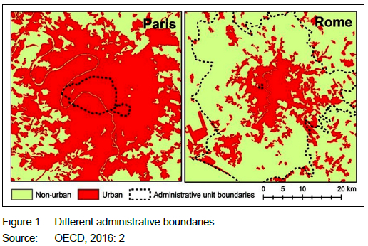
In the above case, the administrative boundary around Paris would be intensive or under-bounded, since it only consists of the main urban area, while the functional region sprawls beyond it into alternative administrative regions. Some could argue that this makes the development and management of the functional area rather difficult in economic, social, administrative, and political terms (Webster & Muller, 2004: 283; Feleke, 2018: 127-129; Sikander, 2015: 171). However, in the Paris case, there are 20 smaller local government administrative regions called 'municipal arrondissements' that form part of a larger metropolitan commune entity. Consequently, each arrondissement entity serves the area that it is demarcated to serve, under the leadership of its own mayor and council. It is responsible for managing the community facilities and registering the population in its area. However, each arrondissement is under the management of the Paris council and Commune Mayor. In this case, the local government territory is more intensively developed into smaller administrative areas which allows for more efficient and coordinated management. However, the entire Metropolitan is managed through mutual cooperation. This kind of management is rather costly and tedious to manage.
On the other hand, some municipalities such as Rome, which are monocentric structures, choose to have one large extensive administrative region, which encompasses all the peripheral settlements. The entire region is managed by a single local government under the leadership of a single mayor who takes instructions from the national government (Beauregard, 1991: 190). In this regard, national governments pass laws on how the region should be demarcated and administrated, according to their political value sets, and the administration is carried out by government officials on the local level, in a top-down manner (Beauregard, 1991: 191). However, even in this case, development and management become difficult as the region becomes too large to administer efficiently (Sikander, 2015: 172). Accordingly, the question as to how the boundaries around these administrative regions could be demarcated to allow for the efficient and effective management of the contained settlements remains open (OECD, 2020: 11).
Subsequently, a bottom-up planning approach, which allows for public participation in matters of policy, was introduced towards the late 1980s (Sikander, 2015: 173; UL Haque, 2013: 6). This allowed individuals to communicate on where they would like the administrative boundaries to extend to, with the aim of creating more efficient, effective, integrated, and equitable societies and administrative regions (Sikander, 2015: 174-176). However, the public engagement led to a perpetual altering of processes and goals, which, in turn, compromised efficiency and increased financial cost (Zhou et al., 2016: 2; ul Haque, 2013: 8; Cilliers, 2009: 943).
As a result, during the economic recession of the 2000s, many national governments, globally, sought to And ways to save costs and become more efficient while engaging with the public. This brought about a renewed interest in the local administrative structure within their countries (OECD, 2016: 5). During the post-2000 period, many governments such as the USA, Canada, Australia, Turkey, Denmark, and South Africa legally incorporated settlements to form larger administrative regions, with the hope of containing sprawl and decreasing administrative cost, by encouraging higher density development through infill development (Dollery & Robotti, 2008: 10; Feleke, 2018: 141). In light of this renewed interest, some countries followed international election standards provided by regional and nongovernmental organisations (including the OSCE, the European Commission for Democracy Through Law, the Commonwealth Secretariat, and the Electoral Institute of Southern Africa [EISA]), while other governments created their own criteria on how their local administrative regions should be delimited. Research reveals that, even though definition and terms of administrative categories vary depending on the preferences of countries, most of the administrative regions are delimited based on the natural differentiation of space and the relevant spatial interaction (Halas et al., 2016: 2). Terms such as optimal operations, financial viability, cohesiveness, equality, or functionality are too often used to motivate the delimitation processes (Barlow & Wastl-Walter, 2017: 20; Dampegama et al., 2019: 197; Feleke, 2018: 128).
In the South African case, municipal boundaries needed to be restructured post-1994, from being based on race to being more inclusive, integrated, and cohesive. The challenge, however, came in identifying the correct criteria to address the administrative objectives of a particular country and how this translates into creating efficient municipal regions - in many cases trade-off has to be made.
3.2 Rationales behind administrative delimitation from an urban planning perspective
The delimitation of local municipal boundaries is a significant task considering that they contain multiethnic, multi-religion, and multicultural communities residing in regions that are developed on different levels (Dampegama et al., 2019: 198). Upon review, the criteria found in the literature that guide municipal delimitation have common themes such as population concentrations, functional linkages, cohesiveness, or integration (Handley, 2007: 61-62). With the common principles that underlie municipal delimitations is the hope of creating regions that would ensure optimal usage of resources, decreased expenditure, allow efficient administration, equitable voting capacity, and minimise social conflict while still being transparent in application (Mulindwa, 2020: 3-10). The following criteria are considered for delimiting local administrative boundaries, based on their outcomes and implications.
3.2.1 Agglomeration
Agglomeration economics consists of leveraging the benefits associated with the clustering of economic activities in close proximity with the hope that it will decrease the cost of infrastructure, administration, and production (Giuliano, Kang & Yuan, 2019: 377). In recent years, this criterion has been used in a legislative context in countries such as the UK, Denmark, Australia, Canada, and the USA to motivate administrative delimitation based on its ability to create more efficient, accessible, and viable administrative regions (Glaeser, 2011: 1-5).
In terms of application, national governments legally incorporated smaller settlements that are closely related, in order to create a single larger administrative region with the hope that it would reduce the fixed costs of infrastructure and decrease administrative duplication, while containing sprawl. However, research suggests that the relationship between size, performance, and agglomeration are inconclusive (Soja, 2015), since it is largely unknown how population size decreases the costs of providing services, given that the factors and circumstances of each municipality differ. Furthermore, the delimitation of the boundary in terms of distance from the centre or the size of the municipality or the required density within the municipality is unknown for it to benefit from agglomeration advantages or economics of scale (Giuliano et al., 2019: 379).
However, there is a recognised trade-off between the size of a local authority and the quality of life (Glaeser, 2011: 1-5). Smaller administrative areas with high densities are well known to have higher administrative costs associated with congestion, pollution, social ills, and longer commuting times (OECD, 2020. On the other hand, larger administrations with lower population densities are costly to manage and many do not have the ability to attract investment (OECD, 2020). Subsequently, public choice theorists disagree with the agglomeration economics argument to delimit administrative regions, since they believe that smaller independent administrative regions promote competitive behaviour amidst themselves. This necessitates greater efficiency and quality of services than a single large administration (Combes, Duranton & Gobillon, 2011: 257).
In summary, the agglomeration of scale criterion has been used to support both small and large territories. Small territories with higher densities are delimited to promote economics of scale and reduce administrative costs. Large territories are delimited to counteract sprawl and promote efficiency in terms of administration (Glaeser, 2011: 5). The motivation depends on the legislative stance of the country. For example, Australia reduced its municipalities from 869 in 1980 to 565 in 2014, based on the economics of scale or agglomeration criteria. However, the findings revealed no correlation between city size and performance (Dollery & Byrnes 2008: 5).
3.2.2 Functional linkages
Commuting patterns between settlements are common attributes used globally to delimit local administrative regions (Halas et al., 2016: 2). This is due to the strong socio-economic interrelationship between residential suburbs, peripheral settlements, and commercial centres. However, defining the spheres of influence and the range of the functional activity space involves identifying the settlement typology and measuring commuting patterns between the various settlements. This is challenging, considering that traffic is in constant flux (Martínez-Bernabes, Coombes & Casado-Díaz, 2020: 740743). Furthermore, to date there is no consensus regarding the intensity of the activity or the traffic required for it to form an administrative entity or the method that could be used to determine it (OECD, 2020). Consequently, central governments have to revise their boundaries on an annual or semi-annual basis to keep them updated if they are based on functional linkages, which is costly (Bennett, 1989).
Many governments who use this approach opt for over-bounded local boundaries that extend beyond the range of normal activities of the majority of the people, thus allowing for future growth and expansion (see Rome in Figure 1) (Ramutsindela, 2013: 54). However, the problem with this over-bounded approach is that the region could be too large to administer properly, resulting in the region becoming non-profitable, as in the case of Canada. In Canada, municipalities were decreased from 851 municipalities in 1998 to 444 in 2009, based on mergers and cooperation related to functional linkages, equality, and socio-geographic relationships. However, amalgamation failed to solve any of the problems the municipalities faced prior to amalgamating (Slack & Bird, 2010: 8).
As much as criteria motivate functional linkages as a basis for the legal incorporation of settlements, it is more challenging to implement them in practice and there is currently no consensus on how this can be implemented or measured (Halas et al., 2016: 3; OECD, 2020: 14).
3.2.3 Economic functions
This criterion shares obvious links with the agglomeration economics approach in that a delimited local boundary would have to contain a minimum number of people for it to be economically efficient and effective (Craythorne, 1998: 6; Nijkamp, 2013: 4). In this regard, the less important the economic functions on offer in the centre, the lower the population density required and vice versa (Christaller, 1966; Losch, 1962). This methodology is more objective than the functional linkages and agglomeration, as it enables consistent application (Slack & Bird, 2010: 5). For example, the OECD (2022: 1) proposes that urban areas can be delimited and categorised into four types according to population size:
• Small urban areas, with a population of below 200 000;
• Medium-sized urban areas, with a population of between 200 000 and 500 000;
• Metropolitan areas, with a population of between 500 000 and 1.5 million, and
• Large metropolitan areas, with a population of 1.5 million or more.
Nonetheless, while population number and population density are useful, on their own they do not provide a clear basis on which to determine boundaries or administrative classification, since they do not necessarily reflect the values of the local governments and their political objectives (Cameron, 2006: 80). Furthermore, regions are fluid and will need to be re-examined at least every five to 10 years, depending on the rate of demographic growth, rate of urbanisation, and economic development, which is costly (Giraut & Maharaj, 2002: 26). Moreover, there are many different economic activities and basic services on offer within a municipality, all of which differ in terms of the required threshold to be profitable. Which service or economic function would be given preference to determine the density required within an administrative region?
In Denmark, municipal areas were delimited based on access to health services. The Danish government condensed 1 386 boroughs in 1970 to create 275 municipalities in 2007. However, the cost of providing health services has been higher than expected. Thus, it could be said that delimitation has had limited success (Olejaz et al., 2012).
3.2.4 Socio-demographic
This delimitation criterion seeks to balance the need for speedy and sustainable delivery of services with the concern of addressing inequalities. From a socio-demographic perspective, it is argued that a more equitable distribution of services and taxes could be achieved, by merging a city with its poorer surrounding rural areas through consolidation, incorporation, or amalgamation (Cameron, 2001: 6; Glaeser, 2011: 2). This approach is similar to that adopted by the South African democratic government, which sought to integrate the previously segregated racial groups who had different tax bases (Mabin & Smit, 1997).
However, researchers have reservations about using this criterion to create administrative regions, in order to reduce inequality. As municipalities could risk losing their more affluent ratepayers, who would object to paying higher taxes, the region could instead attract less affluent citizens who do not have funds to pay taxes (Cameron, 2006: 78; Geyer, Geyer & Du Plessis, 2015: 1-2). In addition, if rich and poor areas are consolidated, the tax base has to be divided over a larger area. The question then is: Do you develop the underdeveloped regions with the municipal funds, or should the funds be used to maintain aged infrastructure? In the case of South Africa, this has contributed to the deterioration of local municipalities.
Furthermore, in this delimitation approach, municipalities could also become too large if rural areas are located too far from urban areas. Nevertheless, these scenarios are influenced by the politics of the consolidated municipalities and the preferences of the national government (Cameron, 2001: 5). This approach is believed to bring about spatial equity. However, there is no set way of delimiting the region and there are limited results to prove it to date.
3.2.5 Financial viability
Financial viability is defined as a municipality's ability to meet its expenditure commitments and cost obligations from its own income stream, including revenues, delivery of services, property taxes, and transfers (Harrison & Todes, 2016: 1-5). In other words, if an administrative area is not financially viable, self-sufficient, or self-reliant, it will not be able to afford its expenses from its own revenue and will depend on funding from national government (Khumelo & Ncube, 2016: 6-8). Thus, it needs to be an optimal size for it to have a tax base that will enable it to be profitable and financially viable (Rondinelli, McCullough & Johnson, 2012: 57-60). Optimal, in this sense, refers to the urban size or administrative region that would offer the greatest return. This is where the total benefit (average revenue and marginal revenue) is higher than the total cost (average cost and marginal cost) (Camagni, Diappi & Leonardi, 1986: 150). The problem, however, is: How would the boundary be delimited to ensure viability? Would it be based on the number of businesses in the area that pay taxes (as the economic approach discussed in 3.2.3), or would it require a certain number of employed citizens who pay taxes and rates? This is unclear.
According to Khumelo and Ncube (2016: 5), there is no apparent connection between financial viability and delimitation, since many factors, including poor management, political and administrative issues, poor investment decisions, low revenue bases, unemployment, high dependency, and poverty levels within its borders, can cause a municipality to become financially non-viable (Rondinelli et al., 2012: 57-60). Hence, legal incorporation will not necessarily make weaker municipalities financially viable, self-sufficient, or self-reliant, but could result in the contrary if internal issues are not addressed appropriately (Cameron & Meligrana, 2010: 10). In addition, it is not known whether larger municipalities would be more financially viable or whether smaller municipalities would be better. This also ties in with the agglomeration criterion.
In South Africa, financial viability was a delimiting criterion between 2011 and 2016. The Municipal Demarcation Board claimed that, by merging financially non-viable municipalities with financially viable municipalities, they would be self-sufficient (Thupane, 2015). However, in 2022, at least one third of the South African municipalities were dysfunctional. This brings into question the success of the mergers (Jeeva & Cilliers, 2021: 83).
3.2.6 Cohesiveness or nation building
There is growing evidence that social infrastructure, as opposed to physical infrastructure, creates a sense of community (Aldrich & Kyota, 2017). The reason for this is that social infrastructure creates a form of collective identity that requires common history, culture, geography, as well as social and economic conditions. This is, however, a complex social construct, due to different societies having different geographies, political representations, economics, and problems (Fonseca, Lukosch & Brazier, 2019: 231-240).
In light of this, some countries believe that smaller administrative units offer a more socially homogeneous composition and a greater sense of community, as in the apartheid model of the South African government (Skaburskis, 1992: 161). Alternatively, ethnic lines could be exchanged with national lines to create a large municipality with a heterogeneous population to incorporate a nationalist mindset -similar to the democratic government of South Africa. However, this heterogeneity could and does give rise to cultural conflict and feelings of under-representation on the part of the minority populations (Fonseca et al., 2019: 231-245; Cameron, 2001: 9). Thus, a legal incorporation based on cohesiveness depends on the political value preferences of the national government. How big or small these administrative regions need to be is also left open and differs according to context.
3.2.7 Political motivations
Equality of voting strength is a recurrent principle found in delimitation reports. In many cases, this comes in the form of political motivations for local administrative boundary adjustments. However, government is not always candid and the motivation comes in the form of quoting 'efficiency, sustainability, equity, viability, inclusive and integration'. Each of these principles is important but cannot be objectively measured or determined, since it differs according to context (Dampegama et al., 2019: 197). This makes the motivation and rationale elusive and easy to manipulate, in order to reach alternative political objectives.
According to Stabingis (2015: 3), one of the telling signs that politicians are seeking influence over administrative regions to secure maximum votes is when these regions are often larger than others and do not offer much equity to the citizens. This guarantees the ruling power within that region more parliamentary seats. However, this criterion is not acknowledged and not openly discussed, making it challenging to measure and contest (Cameron, 2001: 8; Barlow & Wastl-Walter, 2017: 50).
From the above review, it can be concluded that there is currently no well-defined, precise, best single model for the delimitation of local administrative boundaries. Many criteria, some of which are opposing, are used to motivate the delimitation of local boundaries. The review also highlights that the criterion can be defined and measured in different ways. As a result, the outcome differs according to context and the country implementing it. If anything, the review highlights the complexity and the lack of objectivity in delimiting local boundaries, making it difficult to apply consistently and easy to manipulate.
4. DISCUSSION
The delimitation of administrative regions leads to the categorisation of administrative units, which are important for strategic planning and policy implementation. The approach to delimiting administrative regions was previously based on a top-down modernist approach, solely based on the desires of the central government (see section 3.1) (Beauregard, 1991: 191). Since the 1980s, a more liberal bottom-up approach was adopted to allow communities to have input on how boundaries should be delineated (Sikander, 2015: 173). However, due to the multicultural background and various motivating factors, the delineation based on public opinion was challenging. As a result, in recent years, there has been a further shift in the search for a middle ground between top-down and bottom-up planning to create more efficient and administratively effective, as well as context-sensitive regions. Consequently, many governments employed independent delimitation commissions to delimit and standardise their local administrative regions, in categories based on legislation and public consultation. It was anticipated that the standardisation would help compare, plan, and implement a strategic socio-economic policy.
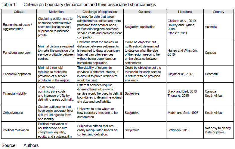
The review identified criteria that guide delimitation globally post-2000, in terms of their objectivity (it can be measured and is transparent) and subjectivity (based on qualitative data and cannot really be measured) (see Table 1).
From Table 1, it can be noted that criteria guiding delimitation are currently subjective and context specific. As a result, the outcomes are inconsistent and lack transparency and can be easily manipulated in the method of delineation. For instance, the motivation to create compact administrative regions, by increasing density and clustering services and infrastructure, comes about strongly in the agglomeration economics, socio- geographic and financial viability motivations. This is why the functional, economic, and cohesive approaches appear to support larger and more integrated regions, in order to increase the market area and decrease administrative costs. However, all these criteria are subjective and applied according to the importance provided by central government. Consequently, the subjectivity is open to political manipulation which could easily be packaged differently, since principles such as integration, equity, and equality cannot be measured spatially.
Furthermore, even though all the above-mentioned criteria are important for administrative delineation, the simultaneous implementation of all delimitation criteria and principles is not always possible. There must be trade-offs and negotiations between numerous independent participants such as businesses, lobbyists, politicians, real-estate developers, and the public (Glushko, 2016: 52). Accordingly, the outcome of the delimited region could mean smaller or larger municipalities.
Moreover, the delimited administrative regions need to be categorised, in order to provide an understanding of the region. Since the delimitation is based on a tradeoff between many choices, including the nature of resources, the purpose of the delimitation, the effort put into the delimitation, the intricacy of the domain, and the capabilities of the people doing the delimitation, the result is biased in one way or another and largely inconsistent. Globally, many administrative boundaries have had to be re-delimited since the early 2000s to either separate areas that have fused or consolidate areas that were functionally related, in order to combat sprawl, promote smart growth, efficient management, and enforce authority over a region. Considering the contemporary relevance of the exercise and the impact of administrative delineation in a country, it would have been expected that a clear method would be prescribed, at least from a theoretical perspective, on how local boundaries could be demarcated. However, this study found that there are not many theories or technical methodologies that could be referred to, in order to guide delimitation.
5. CONCLUSIONS
This article showed that the principled approach based on subjective criteria does not necessarily mean that it is transparent or that it is consistently applied. This results in there being no way of comparing and contrasting administrative units globally. This makes it difficult to determine what is efficient and what can be applied to make the administrative units more effective and optimal (OECD, 2020: 12).
Subsequently, it could also be argued that the criteria discussed above are too focused on the effective and efficient governance of municipalities and do not take note of sustainability or quality of life. In light of this, the 2030 Agenda for Sustainable Development (UN 2015) includes several indicators that could be collected for cities or for rural and urban areas to ensure sustainable delimitation and categorisation. However, the data required to apply contemporary methodologies are not always collected across countries.
This article recommends that further research be conducted on how administrative regions could be delimited based on the quality of life in administrative regions to be more socially conscious and sustainable. It further reveals that the application of classic theories in delimiting regions is subjective and that the outcome differs according to context. This article calls for more objective criteria to be developed, in order to ensure that delimited regions are used not only to increase profits, but also to promote sustainability and offer a good quality of life to all within the administrative regions.
ACKNOWLEDGEMENTS
This work is based on research supported by the National Institute for The Humanities and Social Sciences.
REFERENCES
ALDRICH, D.P. & KYOTA, E. 2017. Creating community resilience through elder-led physical and social infrastructure. Disaster Medicine and Public Health Preparedness, 11(1), pp.120-126. DOI: 10.1017/dmp.2016.206 [ Links ]
BARLOW, M. & WASTL-WALTER, D. 2017. New challenges in local and regional administration. London, UK: Routledge. DOI:10.4324/9781315248110 [ Links ]
BEAUREGARD, R.A. 1991. Without a net: Modernist planning and the postmodern abyss. Journal of Planning Education and Research, 10(3), pp.189-194. DOI:10.1177/0739456x9101000305 [ Links ]
BENNETT, R. 1989. Territory and administration in Europe. London, UK: Pinter. [ Links ]
CAMAGNI, R., DIAPPI, L. & LEONARDI, G. 1986. Urban growth and decline in a hierarchical system. A supply-oriented dynamic approach. Regional Science and Urban Economics, 16(1), pp.145-160. DOI:10.1016/0166-0462(86)90017-7 [ Links ]
CAMERON, R. 2001. The upliftment of South African local government? Local Government Studies, 27(3), pp. 97-118. DOI:10.1080/714004109 [ Links ]
CAMERON, R. 2006. Local government boundary reorganization. In: Pillay, U., Tomlinson, R. & Toit, D. (Eds). Democracy and delivery: Urban policy in South Africa. Cape Town: HSRC Press, pp. 76-106. [ Links ]
CAMERON, R.G. & MELIGRANA, J. 2010. Criteria for determining municipal boundaries and categorisation of metropolitan municipalities. MDB (Bid No. A03/2010). Pretoria: MDB Publication. [ Links ]
CHRISTALLER, W. 1933. (1966) Central places in Southern Germany. Translated by C. Baskin. Englewood Cliffs, NJ: Prentice Hall. [ Links ]
CILLIERS, J.E. 2009. The Urban Development Boundary as a planning tool for sustainable urban form: The South African situation. International Journal of Humanities and Social Sciences, 3(6), pp. 942-947. DOI: 10.5281/zenodo.1078478 [ Links ]
COMBES, P.-P., DURANTON, G. & GOBILLON, L. 2011. The identification of agglomeration economies. Journal of Economic Geography, 11(2), pp. 253-266. DOI: 10.1093/jeg/lbq038 [ Links ]
CRAYTHORNE, D.L. 1998. Municipal administration: A handbook. 4th edition. Cape Town, South Africa: Juta Academic. [ Links ]
DAMPEGAMA, K.P., HALANAYAKE, N.T. & RANAWAKA, C. 2019. Delimitation of administrative boundaries: History, importance and using Geographic Information System for improved delimitation of administrative boundaries. In: Proceedings of the 12th International Research Conference, 11-12 September, Kotelawala Defence University (KDU), Ratmalana, Sri Lanka, pp. 197-208. [ Links ]
DOLLERY, B. & BYRNES, J. 2008. Local government amalgamation: A conceptual analysis population size and scale economies in municipal service provision. Australasian Journal of Regional Studies, 14(2), pp. 167-175. [ Links ]
DOLLERY, B.E. & ROBOTTI, L. (Eds). 2008. The theory and practice of local government reform. Cheltenham, England: Edward Elgar Publishing. https://doi.org/10.4337/9781781956687 [ Links ]
DRUPAL. 2021. Administrative boundary hierarchy. [Online]. Available at: <https://www.drupal.org/node/2063033> [Accessed: 12 May 2022]. [ Links ]
FELEKE, A.T. 2018. The dilemma of determining urban administrative boundary for land administration: The case of Shire Inda Silase. International Journal of Social Sciences Perspectives, 2(2), pp. 126-160. DOI: 10.33094/7.2017.2018.22.126.160 [ Links ]
FONSECA, X., LUKOSCH, S. & BRAZIER, F. 2019. Social cohesion revisited: A new definition and how to characterize it. Innovation, 32(2), pp. 1-23. DOI: 10.1080/13511610.2018.1497480 [ Links ]
FRIEDMANN, J. 1978. The spatial organization of power in the development of urban systems. In: Bourne, L.S. & Simmons, J.W. (Eds). Systems of cities: Readings on structure, growth, and policy. New York: Oxford University Press, pp. 328-339. [ Links ]
FULKERSON, A.L., WAXMAN, S.R. & SEYMOUR, J.M. n.d. Linking object names and object categories: Words (but not tones) facilitate object categorization in 6- and 12-month-olds, Www.bu.edu. [Online]. Available at: <https://www.bu.edu/bucld/files/2011/05/30-FulkersonBUCLD2005.pdf> [Accessed: 8 August 2022]. [ Links ]
GEYER, H.S., Jr, GEYER, H.S. & DU PLESSIS, D. 2015. Primary cities in sub-Saharan Africa: Quasars, loose connections, and black holes. International Planning Studies, 20(1-2), pp. 39-51. DOI: 10.1080/13563475.2014.942494 [ Links ]
GIRAUT, F. & MAHARAJ, B. 2002. Contested terrains: Cities and hinterlands in post-apartheid boundary delimitations. GeoJournal, 57(1/2), pp. 39-51. DOI: 10.1023/a:1026018819206. [ Links ]
GIULIANO, G., KANG, S. & YUAN, Q. 2019. Agglomeration economies and evolving urban form. The Annals of Regional Science, 63(3), pp. 377-398. DOI: 10.1007/s00168-019-00957-4 [ Links ]
GLAESER, E.L. 2011. Introduction to "Agglomeration Economics". In: Glaeser, E.L. (Ed.). Agglomeration economics. Chicago, Illinois: The University of Chicago Press, pp. 1-14. https://doi.org/10.7208/chicago/9780226297927.003.0001 [ Links ]
GLUSHKO, R.J. 2016. The discipline of organizing: Professional edition. 4th edition. Sebastopol, CA, USA.: O'Reilly Media, Inc. [ Links ]
HALAS, M., MARTIN, E., PAVEL, K. & MARTIN, T. 2016. Efficiency of delineation of administrative regions: A functional region approach. In: Proceedings of the 19th International Colloquium on Regional Sciences, 15-17 June, Cejkovice, Czech Republic, pp. 565-572. 10.5817/CZ.MUNI.P210-8273-2016-72 [ Links ]
HANDLEY, L. 2007. Challenging the norms and standards of election administration: Boundary delimitation. IFES White Paper funded by USAID, pp. 59-77. [ Links ]
HANES, N. & WIKSTRÖM, M. 2010. Amalgamation impacts on local growth: Are voluntary amalgamations more efficient than compulsory amalgamations? Canadian Journal of Regional Economics, 33(1), pp. 57-70. [ Links ]
HARRISON, P. & TODES, A. 2016. Spatial transformations in a "loosening state": South Africa in a comparative perspective. Geoforum, 61, pp. 148-161. https://doi.org/10.1016/j.geoforum.2015.03.003 [ Links ]
JEEVA, Z. & CILLIERS, J. 2021. An explorative approach to the evolving municipal landscape of South Africa: 1993-2020. Town and Regional Planning, 78, pp. 81-91. https://doi.org/10.18820/2415-0495/trp78i1.6 [ Links ]
KHUMELO, B. & NCUBE, M. 2016. Financial and functional viability and sustainability of municipalities: Beyond the demarcation instrument. Paper presented at the MDB Conference on Demarcation and Spatial Transformation. Financial and Fiscal Commission, Pretoria, 23 June [ Links ]
LÖSCH, A. 1962. Die räumliche Ordnung der Wirtschaft. 3rd edition. Berlin, Germany: De Gruyter Oldenbourg. [ Links ]
MABIN, A. & SMIT, D. 1997. Reconstructing South Africa's cities? The making of urban planning 1900-2000. Planning Perspectives, 12(2), pp. 193-223. DOI: 10.1080/026654397364726 [ Links ]
MARTÍNEZ-BERNABEU, L., COOMBES, M. & CASADO-DÍAZ, J.M. 2020. Functional regions for policy: A statistical 'toolbox' providing evidence for decisions between alternative geographies. Applied Spatial Analysis and Policy, 13(3), pp. 739-758. DOI: 10.1007/s12061-019-09326-2 [ Links ]
MULINDWA, P. 2020. Interstate border conflicts and their effects on region-building and integration of the east African community. African Journal of Governance and Development, 9(2), pp. 599-620. DOI: 9971-1-10-20201223 [ Links ]
NIJKAMP, P. 2013. The universal law of gravitation and the death of distance. Romanian Journal of Regional Science, 7(2), pp. 1-10. [ Links ]
OECD (Organization for Economic Cooperation and Development). 2016. Comparison of administrative boundaries and the urban extent of cities. /Online]. Available at: <https://www.oecd-ilibrary.org/sites/ba8c7dc7-en/index.html?itemId=/content/component/ba8c7dc7-en> [Accessed: 10 January 2022]. [ Links ]
OECD (Organization for Economic Cooperation and Development). 2020. Why delineate functional areas in all territories? In: OECD Territorial reviews - Delineating functional areas in all territories, pp. 11-18. https://doi.org/10.1787/07970966-en [ Links ]
OECD (Organization for Economic Cooperation and Development). 2022. Urban population by city size (indicator). OECD iLibrary. DOI: 10.1787/b4332f92-en [ Links ]
OLEJAZ, M., NIELSEN, J., RUDKJOBING, A., BIRK, O., KRASNIK. A. & HERNANDEZ- QUEVEDO, C. 2012. Denmark: Health system review. Health System Transit, 4(2), pp. 1-192. PMID: 22575801. [ Links ]
RAMUTSINDELA, M.F. 2013. Experienced regions and borders: The challenge for transactional approaches. Regional Studies, 47(1), pp. 43-54. https://doi.org/10.1080/00343404.2011.618121 [ Links ]
RONDINELLI, D.A., MCCULLOUGH, J.S. & JOHNSON, R.W. 2012. Analysing decentralization policies in developing countries: A political-economy framework. Development and Change, 20(1), pp. 57-87. https://doi.org/10.1111/j.1467-7660.1989.tb00340.x [ Links ]
SIKANDER, T. 2015. A theoretical framework of local government. International Journal of Humanities and Social Science, 5(6), pp. 171-178. [ Links ]
SINCLAIR-SMITH, K. 2015. Polycentric development in the Cape Town city-region: Empirical assessment and consideration of spatial policy implications. Development Southern Africa, 32(2), pp. 131-150. DOI: 10.1080/0376835X.2014.984378 [ Links ]
SKABURSKIS, A. 1992. Goals for restructuring local government boundaries: Canadian lessons. Environment and Planning C: Government and Policy, 10(2), pp. 159-172. https://doi.org/10.1068/c100159 [ Links ]
SLACK, E. & BIRD, R. 2010. Merging municipalities: Is bigger better? [Online]. Available at: <https://tspace.library.utoronto.ca/bitstream/1807/81253/1/imfg_paper_14_slack_bird_Feb_27_2013.pdf> [Accessed: 5 May 2017]. [ Links ]
SOJA, E. 2015. Accentuate the regional. International Journal of Urban and Regional Research, 39(2), pp. 372-381. doi.org/10.1111/1468-2427.12176 [ Links ]
SPORNA, T. & KRZYSZTOFIK, R. 2020. Inner suburbanisation -Background of the phenomenon in a polycentric, post-socialist and post-industrial region. Example from the Katowice conurbation, Poland. Cities, 104, article number 102789. DOI: 10.1016/j.cities.2020.102789 [ Links ]
STABINGIS, R. 2015. Case study: Equal voting power and boundary delimitation in Lithuania. [PPT]. [Online]. Available at: <https://aceeeo.org/sites/default/flles/case_study_equal_voting_power_and_boundary_delimitation_in_lithuania.pdf> [Accessed: 5 July 2018]. [ Links ]
THUPANE, J. 2015. SA municipal boundaries changed ahead of 2016 elections. [Online]. Available at: <https://businesstech.co.za/news/government/97069/sa-municipal-boundaries-changed-aheadof-2016-elections/> [Accessed: 5 July 2018]. [ Links ]
UL HAQUE, A. 2013. Theoretical perspective of local government: Literature review. Munich Personal RePEC Archive. MPRA Paper No. 45868. [Online]. Available at: <https://mpra.ub.uni-muenchen.de/45868/> [Accessed: 2 August 2022]. [ Links ]
UN (United Nations). 2012. Chapter III: Towards sustainable cities. [Online]. Available at: <http://www.un.org/en/development/desa/policy/wess/wess_current/wess2013/Chapter3.pdf> [Accessed: 2 February 2017]. [ Links ]
UN (United Nations). 2015. 2030 Agenda for Sustainable Development [Online]. Available at: <https://www.undp.org/sustainable-development-goals> [Accessed: 2 February 2017]. [ Links ]
VASANEN, A. 2012. Functional polycentricity: Examining metropolitan spatial structure through the connectivity of urban sub-centres. Urban Studies, 49(16), pp. 3627-3644. DOI: 10.1177/0042098012447000 [ Links ]
WEBSTER, D. & MULLER, L. 2004. Peri-urbanization: Zones of rural-urban transition. In: Sassen, S. (Ed.). Human settlement development, volume 1. Chapter 13. Paris, France, UNESCO: Eolss Publishers, pp. 281-290. [ Links ]
ZHANG, X.Q. 2016. The trends, promises and challenges of urbanisation in the world. Habitat International, 54, pp. 241-252. DOI: 10.1016/j.habitatint.2015.11.018 [ Links ]
ZHOU, R., ZHANG, H., XIN-YUE, Y., WANG, X. & SU, H. 2016. The delimitation of urban growth boundaries using the CLUE-S land-use change model: Study on Xinzhuang town, Changshu city, China. Sustainability, 8(11), article number 1182. DOI: 10.3390/su8111182 [ Links ]
Received: February 2022
Peer reviewed and revised: March 2022
Published: June 2023
* The author(s) declared no potential conflicts of interest with respect to the research, authorship, and/or publication of this article

