


Servicios Personalizados
Articulo
 Inglés (pdf)
 Articulo en XML
 Referencias del artículo
Indicadores

Links relacionados
-
 Citado por Google
 -
 Similares en Google
Compartir

 Permalink
Town and Regional Planning
versión On-line ISSN 2415-0495
versión impresa ISSN 1012-280X
Town reg. plan. (Online) vol.82 Bloemfontein 2023
http://dx.doi.org/10.18820/trp.v82i.7117
RESEARCH ARTICLE
Urban pressure on the Rietvlei Nature Reserve in Tshwane, South Africa: An application of the Greenspace Stress Model of Urban Impact
Stedelike druk op die rietvlei natuurreservaat in Tshwane, Suid-Afrika: 'n toepassing van die stresmodel van stedelike impak op groen ruimtes
Khatello ea litoropo tikolohong ea polokeho ea tlholeho rietvlei Tshwane, Afrika Boroa: tsebeliso ea greenspace stress model of urban impact
Anna de Jager
Senior lecturer, Department of Geography, University of South Africa, Unisa Science Campus, Johannesburg, South Africa. Phone: 011-4712022, email: djageae@unisa.ac.za, ORCID: https://orcid.org/0000-0003-1852-6791
ABSTRACT
Despite the ecosystem services potentially provided by urban green spaces, there are concerns about the sustainability thereof. Therefore, the nexus between development, conservation, and sense of place was explored from a geographical perspective. A Greenspace Stress Model of Urban Impact was developed through a case study of the Rietvlei Nature Reserve in Tshwane, Gauteng province, South Africa. The position of an urban green space within two rapidly expanding cities was evaluated through a case study. Methods included a literature study, an analysis of land-use changes on remote sensing images, face-to-face interviews, and focus group interviews. Findings from this research include that urban growth leads to increasing human needs and expectations regarding the ecological services provided by green spaces. Stressors within the reserve include the water quality, the presence of invasive species, development pressures intensified by the location relative to spatial development corridors and administrative boundaries, and insufficient environmental awareness. Successful local strategies support the idea that green space should be fit for purpose and meet the expectations justifying its existence. Global environmental concerns should be considered in urban planning frameworks and in management of local spaces that people know and care about. The physical characteristics and functions of an urban green space as well as the environmental perception and sense-of-place evaluations of different stakeholders are important in decision-making about, and sustainability of ecosystem services.
Keywords: Conservation, development, environmental change, human-environment interaction, urban pressure, geography, water, Rietvlei Nature Reserve, Tshwane
OPSOMMING
Ten spyte van die ekosisteem-dienste wat stedelike groen ruimtes moontlik kan bied, is daar kommer oor die volhoubaarheid daarvan. Die wisselwerking tussen ontwikkeling, bewaring en pleksin is dus vanuit 'n geografiese perspektief ondersoek.
'n Stresmodel van stedelike impak op groen ruimtes (GSMUI) is ontwikkel deur middel van 'n gevallestudie van die Rietvlei Natuurreservaat in Tshwane, Gauteng-provinsie, Suid-Afrika. 'n Gevallestudie is gebruik om die posisie van 'n stedelike groen ruimte tussen twee snelgroeiende stede te evalueer. Metodes sluit in 'n literatuurstudie, 'n ontleding van grondgebruiksveranderinge op afstandswaarneming-beelde, persoonlike onderhoude, en fokusgroep onderhoude. Bevindings van hierdie navorsing sluit in dat stedelike groei lei tot toenemende menslike behoeftes en verwagtings rakende die ekologiese dienste wat stedelike groen ruimtes bied. Stressors in die reservaat sluit in die watergehalte, die voorkoms van indringer spesies, ontwikkelingsdruk wat vererger word deur die ligging in verhouding tot ruimtelike ontwikkelingskorridors en administratiewe grense, asook onvoldoende omgewingsbewustheid. Suksesvolle plaaslike strategieë ondersteun die idee dat groen ruimtes effektief moet wees en aan die verwagtinge wat die bestaan daarvan skep, moet voldoen. Stedelike beplanningsraamwerke en die bestuur van plaaslike ruimtes wat mense ken en waarvoor hulle omgee, behoort wêreldwye omgewingskwessies in ag te neem. Die fisiese eienskappe en funksies van stedelike groen ruimtes asook die omgewingspersepsie en pleksin-evaluerings van verskillende belanghebbers is belangrik vir die volhoubaarheid van en besluitneming oor ekosisteemdienste.
KAKARETSO
Leha ho na le lits'ebeletso tsa tikoloho tse ka fanoang ke libaka tsa tlholeho litoropong, ho na le matsoenyeho mabapi le ho tsoarella ha tsona. Ka hona, kamano pakeng tsa nts'etsopele, paballo, le maikutlo a sebaka e ile ea hlahlojoa ho latela sebaka. Mohlala oa Greenspace Stress Model of Urban Impact o ile oa sebelisoa ho etsa boithuto Rietvlei Nature Reserve e Tshwane, profinseng ea Gauteng, Afrika Boroa. Maemo a sebaka sa thloleho ka har'a litoropo tse peli tse ntseng li hola ka potlako a ile a batlisisoa boithutong bona. Mekhoa ea patlisiso e nee kenyellelitse boithuto ba lingoliloeng, tlhahlobo ea itsoantso tsa liphetoho tsa tsebeliso ea mobu, 'moho le lipuisano le batho ka bomong le ka lihlopha. Tse fumanehileng phuputsong ena li kenyeletsa hore kholo ea litoropo e eketsa litlhoko le litebello tsa batho mabapi le litsebeletso tsa tikoloho tse fanoang ke libaka tsa thloleho. Likhatello ka har'a sebaka sa polokelo li kenyelletsa boleng ba metsi, boteng ba mefuta e hlaselang ea limela, likhatello tsa nts'etsopele tse matlafatsoang ke sebaka se amanang le meeli ea tsamaiso, le tlhokomeliso e sa lekaneng ka tikoloho ho sechaba. Mekhoa e atlehileng ea sebaka seo e tsehetsa khopolo ea hore libaka tsa tlhloleho li lokela ho ho ananela litebello tse tiisang boteng ba tsona. Matsoenyeho a tikoloho a akaretsang lefats'e a lokela ho kenyeletsoa har'a meralo ea litoropo le taolong ea libaka tsa lehae tseo batho ba li tsebang le ho li tsotella. Litsobotsi le mesebetsi ea sebaka sa tlholeho se kahara toropo hammoho le maikutlo a tikoloho e'o, le litekolo tsa maikutlo a ba amehang ba fapaneng li bohlokoa ha ho etsoa liqeto mabapi le ho tsoarella ha litsebeletso tsa tikoloho.
1. INTRODUCTION
Landscapes and land-use patterns are dynamic in urban fringe areas. Land-use changes associated with urban development led to the question as to why it is important to conserve urban green spaces. This is not a new question. In fact, the Ancient Greek philosopher Plato understood the interdependent relationship between human beings and the natural environment, as he lamented the deforestation around Athens, due to shipbuilding and the use of wood for fuel, while his student, Aristotle, regarded nature as a wild beast to be tamed (Ndubisi, 2014: 13-19). Environmental concerns became increasingly evident in the second half of the 20th century, as environmental degradation negatively impacts on human quality of life (Fuggle & Rabie, 1992: 1). The concept of sustainable development is based on social, economic, and environmental dimensions. There are various international agreements and conventions for sustainable development, on the basis of which local frameworks are developed. The challenge is that, when natural resources are protected, the untapped economic potential may not be realised, or human needs not met. On the other hand, population pressures cause strain on the management of environmental resources (Du Toit et al., 2018: 258).
Worldwide, development is changing the biosphere and the ecological life support systems such as clean water, soil, and biodiversity on which human beings depend. However, this is also true of the character of a particular place such as Rietvlei Nature Reserve in South Africa, to which people are connected and for which they care. There is growing concern over the sustainability of environmental processes amidst social and economic development (Schäffler & Swilling, 2013: 247-257; Millennium Ecosystem Assessment, 2005: 19). The loss of biodiversity, use of freshwater, land-use changes, and access of local communities to resources for livelihoods are important in this regard.
The policy imperatives, under the umbrella of the National Environmental Management Act, No. 107 of 1998 (RSA, 1998), aim to improve environmental quality and sustainable development in South Africa. The intention is to protect water resources, biodiversity, endangered species, agricultural resources, marine areas, protected areas, and cultural heritage. The Spatial Planning and Land Use Management Act (SPLUMA), No. 16 of 2013 (RSA, 2013), provides a framework for spatial planning and land-use management across different spheres of government. Provincial and municipal integrated spatial development plans are developed within the legislative framework of the Local Government: Municipal Systems Act, No. 32 of 2000 (RSA, 2000). Urban greenspace is included as green infrastructure within these planning frameworks and policies (City of Tshwane, 2016; Schäffler & Swilling, 2013: 247-257). Bioregional plans on local level also map critical biodiversity areas and ecological support areas that need to be protected from development (Fisher, 2017: 16).
Urban green space has the potential to be a vital resource for promoting both the physical and mental health and well-being of people living in urban areas, and, at the same time, these spaces have value for the conservation of biodiversity. The diversified ecosystem services provided by green spaces are, however, doing more than merely enhancing the quality of life through accessing it for recreation. Ecosystem functions and the associated ecosystem services (Schäffler & Swilling, 2013: 247-257; Millennium Ecosystem Assessment, 2005:19) support resilience in the face of climate change.
The focus of the Rietvlei Nature Reserve case study is not on conservation for tourism, but rather on the importance of environmental awareness of ecological services and sense of place for the management of urban green space. As the Rietvlei Nature Reserve is more than an urban green space for recreation, visitors are not always aware of the range of ecosystem services provided by the urban green space or the stressors that may threaten the sustainability thereof (De Jager, 2020: 240). A guideline to understanding the geographical nexus between urban development, conservation, and sense of place in urban green spaces in South Africa is important not only to consider how urban development affects changes in the land use and morphology of the city and the landscape, but also to establish the functions and the varied use of a particular greenspace.The study, therefore, proposes a Greenspace Stress Model of Urban Impact (GSMUI) in a South African context and develops implementation guidelines for the model. The model was developed by mapping and assessing the implications and challenges of urban growth, exploring and analysing the prominent functions of the reserve through literature, observations, and by conducting semi-structured interviews. The South African government and policymakers can consider the GSMUI to assess the importance of the provisioning function of green spaces. This is important, due to increasing development pressures on urban green space, despite the potential benefit thereof for human quality of life and environmental sustainability.
2. LITERATURE REVIEW
2.1 Urban development
Political decision-making and the dualistic social structure of the South African society have influenced the spatial development of South African cities. Since 1994, there have been major changes in the South African spatial development policies and instruments aimed at restructuring cities toward a compact, high-density urban form with mixed uses (RSA, 2000). It remains challenging to balance the competing "agendas for the provision of basic needs, social services and utilities against the stimulation of economic development and employment, the management of city growth, and the protection of environmental resources and systems" (City of Cape Town, 2012: 29).
On the provincial level, the Gauteng Spatial Development Framework 2030 (Gauteng Provincial Government, 2017) serves to direct the spatial and economic transformation of the province. Transport networks are important in the structure of spatial development plans. The concepts of nodes and corridors have been applied to link economic nodes and residential areas for integrated development (Brand, Geyer & Geyer, 2017: 311). The aim of a spatial development planning strategy using nodes and corridors is to unlock economic potential through linkages in network (Brand & Drewes, 2020: 122; Brand et al., 2017: 311; Gauteng Provincial Government, 2017; Horn, 2010: 42; Horn, 2018: 959; Sihlongonyane, 2018: 25).
Metropolitan restructuring implies the re-delimitation of municipal boundaries and areas of jurisdiction for service delivery (RSA, 2000). Service provision to a growing population remains challenging, and this is especially true in respect of the expansion of service networks to areas outside previous priority areas and the formalisation of spontaneous informal urban development (City of Tshwane, 2018/2019: 1). Integrated development programmes on local level guide budget priorities for development projects and improved municipal service delivery.
2.2 Green space
There are various types of green spaces in the city, ranging in size and form - from manicured gardens, sports fields, and sidewalks to wilderness areas (Wohlitz, 2016: 83). Green spaces often tend to become multifunctional, due to the declining availability of space in the city. Hence, if a particular green space is fit for purpose, there is a balance. However, in the nexus between urban development, conservation, and sense of place, stressors may develop that put the sustainability of the urban green space at risk (De Jager, 2020: 263-284; Pasquini & Enqvist, 2019: 8-10). It is, therefore, essential for managers to identify potential stressors and then apply relevant mitigation strategies for sustainable use of urban green space and to support human quality of life.
Healthy ecosystems are vital for biodiversity and human quality of life (Seiwert & Rößler, 2020; Bernstein, 2017: 219-222; Millennium Ecosystem Assessment, 2005: 19). Although the physical and psychological benefits of human interaction with nature are well documented (World Health Organization, 2016), the benefits of green spaces in the city are greater than the use thereof by the adjacent communities (Seiwert & Rößler, 2020: 104785; Wohlitz, 2016: 83). The role that wetlands, peat, and grasslands play in establishing green infrastructure for water provisioning is widely acknowledged (Zhao, Liu & Wu, 2020: 793). In New York City, for example, green spaces were planned within the framework of protecting the ecosystem functions of a green space rather than focusing on the recreational activities only (Bernstein, 2017: 219-222). Green infrastructure implies that various elements such as conservation areas, rivers, waterway parks, cemeteries, tree-lined streets, gardens, and green roofs are connected into a functioning system that supports ecological processes (Wohlitz, 2016: 83). Green infrastructure can also be used to augment grey infrastructure for water provisioning (Seiwert & Rößler, 2020: 104785; Artmann, Kohle, Meinel, Gan & loja, 2019; Di Marino et al., 2019: 643). The location of natural features such as aquifers and wetlands and their role in green infrastructure should, therefore, be considered in decisions about urban planning and conservation and not only be integrated on a theoretical level (Atumane & Cabral, 2021: 166; Ndubisi, 2014: 13).
The ecosystem services of fresh air, biodiversity, the cooling of the urban heat island effect, water filtration, carbon sequestration, recreation, and aesthetic values are all based on the ecosystem functions of urban green spaces (Millennium Ecosystem Assessment, 2005: 19), adding to the quality of human life. However, the ecosystem services can be sustainable only when critical ecosystem functions are protected or restored. Different perceptions and evaluations of ecosystem functions have proved to be challenging, especially in the Global South (Du Toit et al., 2018: 257-258; De Satgé & Watson, 2018: 11). Green space in African cities such as Lilongwe (Malawi), Kisumu (Kenya), Kumasi (Ghana), and Addis Ababa (Ethiopia) is being threatened in that it must accommodate the increased urbanisation and battles to balance the growing demand for housing and services with the protection of natural areas (Girma, Terefe & Pauleit, 2019: 139). This results in stressors for the management and protection of diverse types of urban green space (Mensah, 2014: 7).
The importance of environmental perception and sense of place is increasingly acknowledged in conservation and environmental management because the connections people have with places could influence their behaviour (Williams & Stewart, 1998: 18-23). Protecting the green infrastructure could also contribute to the distinctiveness of, and sense of place in cities that are changing in the face of rapid population increase and spatial development (Fisher, 2017). An evaluation of the functions of green space in the city and of the reasons for protecting it was thus regarded as important in the context of this study.
2.3 Environmental perception and sense of place
The concept of 'sense of place' has various definitions and applications. According to Montgomery (1998: 93), sense of place is based on the physical characteristics of the place (form), activities (function), as well as images of the place and the connections people have with it. Sense of place is linked to an emotional connection to a place, and it can range from knowledge of a place to willingness to make personal sacrifices to protect the place, or the ideas associated with the place (Shamai, 1991: 349-350). The knowledge and understanding of ecosystems can influence sense of place and the identification of stressors within an urban green space. Sense of place is, therefore, a crucial factor in the sustainable use of urban green space (Hausmann et al., 2015: 120-122). Sense of place is a critical component of an environmental perspective. As a sense of place is related to the meaning attached to a place (Masterson et al., 2017: 49-54) as well as the level of connection to the place or goals of the place (Shamai, 1991: 349-350), it need not be the same for everyone.
Within the context of increasing human needs, a sense of place can influence priorities and decision-making regarding the conservation of urban green space (Masterson et al., 2017; Hausmann et al., 2015: 120-122; Williams & Stewart, 1998: 19-23). Should the ecosystem functions not be understood and supported amidst continuous urban development pressures, the protection of urban green space could be regarded as a barrier to achieving development goals and meeting human needs (Hausmann et al., 2015: 120-122). This is especially important as the protection of ecosystems cannot always be equated in monetary terms (Du Toit et al., 2018). The functions and benefits of urban green space should be identified, in order to establish the reasons for protecting it (Pasquini & Enqvist, 2019: 8; Lindley et al., 2018: 328).
Individual differences such as socio-economic conditions and political stances contribute to different evaluations of a place. This, in turn, influences management decisions. According to De Jager and Nicolau (2020: 921-924), management decisions can influence the life cycle of urban green space. Should relevant mitigation strategies be implemented, ecosystem health can be restored, and the benefits expected from the urban green space maintained. If the stressors within the green space are not effectively managed, this could lead to degradation and even loss of the urban green space. Apart from potentially having local implications, the impact of such loss could have a much wider reach.
2.4 Environmental stressors
Pacione (2001: 401) developed a stress model of urban impact from a social geography perspective. This model considers both the objective characteristics of the urban environment and the subjective experiences thereof (Figure 1). Based on individual characteristics and the socio-economic context, individuals can have different experiences in the city (Pacione, 2001: 398-419). Whenever there is no excessive noise or overcrowding and human needs are met, a situation occurs that Pacione (2001: 401) calls homeostasis. The individual can, however, experience a range of types of stress in the urban setting. For instance, environmental stressors from the physical environment can include (but are not limited to) flooding, earthquakes, landslides, fire, subsidence, and urban climate. Stressors from the sociocultural environment can include overstimulation, crowding, lack of resources, fear, and insufficient provision of services (Pacione 2001: 398-419).
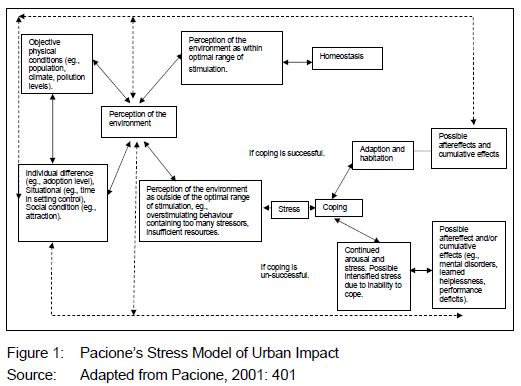
Individuals may experience different stressors in various parts of the city, due to their individual characteristics and their socioeconomic surroundings. Despite possible negative consequences of stress, the balance could be restored if the person manages to implement relevant coping mechanisms. However, if the individual cannot cope with the stressors experienced, it could lead to deviant behaviour or psychological disorders (Rishi & Khuntia, 2012). Stressors could result in mental disorders, learned helplessness, and performance deficit (Pacione, 2003; Pacione, 2001: 401; Nagar, 2006).
According to Pacione (2001: 401), the experiences or perceptions about the city represent a joint function of the environmental conditions and the subjective experience of the individual. The physical characteristics of the urban environment, as well as individual differences, situational and social conditions, tend to feed into environmental perceptions. Should the environmental conditions be perceived within the optimal range of stimulation, the individual would be inclined to experience a sense of homeostasis. However, conditions such as overcrowding, noise, heat, pollution, architectural dysfunction, environmental disasters, or insufficient resources could lead to stress. Individuals experience stress when they cannot cope well with environmental stressors, the severity of which can range from ambient, daily hassles, serious, life changing or catastrophic (Nagar, 2006).
Pacione (2001) emphasises the importance of environmental perception and the application of relevant strategies for individuals to cope with environmental stressors in an urban context. The experiences, knowledge, and skills, as well as the necessary resources available to the individual would influence the selection of coping mechanisms for dealing with the environmental stressors. Both positive and negative experiences feed back into perceptions of the environment and could potentially influence the way in which the individual deals with future events (Figure 1).
The role of sense of place should not be underestimated in the development and implementation of local response plans to environmental stressors (Masterson et al., 2017: 49-54). The connections people have with a place and their awareness of the importance of the ecosystem services can influence decisions made about the conservation thereof.
3. STUDY AREA
The Rietvlei Nature Reserve is a large (40 km2) urban conservation area (City of Tshwane, 2015: 1). The reserve is located between 25°50'S and 25°56'S latitude and 28°15'E and 28°15'E longitude. This is on the border between the Tshwane and Ekurhuleni Metropolitan municipalities in the Gauteng province of South Africa (Figure 2). The Rietvlei Nature Reserve belongs to the Tshwane Metropolitan Municipality and was selected as case study for the research because the nexus between development, conservation, and sense of place is evident in the reserve and surrounding area. The relative location of the Rietvlei Nature Reserve between the M31 (Dam Road) on the northern side, the Delmas Road on the eastern side, and the R21 and the M57 on the western side (Figure 2) is important in this regard. The R21/Nelson Mandela Drive is a national freeway that connects the Pretoria CBD to the Oliver Tambo International Airport as well as Tembisa and the industrial areas in Ekurhuleni. The Pretoria-Kempton Park development corridor (Brand et al., 2017: 311) runs along the R21/Nelson Mandela Drive.
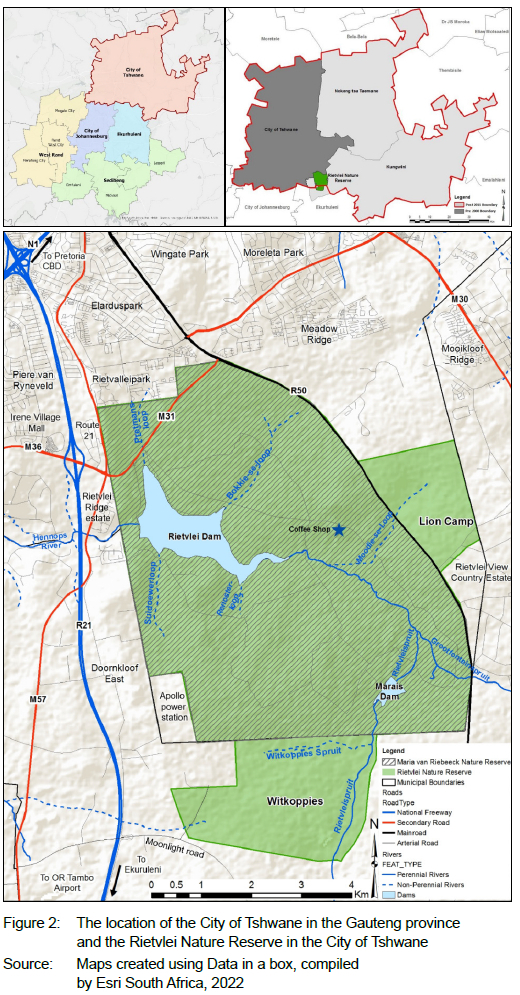
In 2011, the population of the City of Tshwane was 2.9 million. The population size increased to 3.2 million in 2016, making it the district with the third largest percentage population increase in Gauteng between the 2011 Census and the Community Survey of 2016 (Statistics South Africa, 2018). Gauteng does not only have the largest share of the population of South Africa, but it is also experiencing the most rapid population increase. It is, therefore, essential to carefully plan for land-use and land-cover changes, in order to provide for the competing demands associated with urban change, infrastructure development, and service delivery, on the one hand, and protecting the potential benefits associated with green space, on the other. Water provisioning was the raison d'etre for the proclamation of the Rietvlei Nature Reserve which is still an important source of water for the City of Tshwane, providing 40 Ml/day (Mouton et al., 2015: 36). The Lion camp does not seem to be a functional part of the Rietvlei Nature Reserve, since it no longer houses lions, but it still provides a natural buffer around water sources (see Figure 2).
4. METHODOLOGY
4.1 Research design
The research was designed as a single case study of the Rietvlei Nature Reserve within the context of a dynamic urban fringe (Yin, 2012: 8). A qualitative research approach was followed for data collection to identify both the benefits and the stressors experienced in the Rietvlei Nature Reserve. Qualitative data-collection methods included observations, remote sensing, publications and reports, on-site face-to-face interviews, structured interviews, and focus group discussions (Creswell, 2014: 45).
4.2 Data collection
4.2.1 Observation
Observations included using facilities and participating in various activities in the study area. This allowed the researcher to identify issues; to select meaningful focus groups, and to compile appropriate questions for semi-structured interviews. Observations were supported by photographic evidence and a fact sheet for field notes of research experiences reflecting on the physical characteristics of the Rietvlei Nature Reserve, different perceptions of the benefits of, and stressors within the reserve, as well as mitigation measures to deal with stressors.
Observations included the following:
• using available maps to navigate through the Rietvlei Nature Reserve and using picnic facilities at the Marais Dam (30 January 2016);
• a game drive to the lion camp interpreted by a qualified guide (27 July 2016);
• participating in guided walks organised by Friends of Rietvlei (15 October 2016; 20 May 2017);
• accompanying a field guide and learners on an environmental education excursion (31 October 2016);
• attending a working session of Friends of Rietvlei for the eradication of invasive species at the Finfoot Hide (19 November 2016);
• attending two meetings of the Hennops Catchment Management Forum to collect data on issues related to the larger catchment area (30 May 2017; 26 July 2017);
• attending the annual meeting in 2016 of Friends of Rietvlei, as well as a meeting on 8 April 2017 of the committee of the Friends of Rietvlei, and
• collecting photographic evidence covering various visits over
a period of five years and taking field notes based on the researcher's own experiences in support of the validity of observations on economic, environmental, and social benefits of, and stressors within the reserve.
4.2.2 Remote sensing data
The South African National Land Cover Database: 1990 and 2014 was used by the company Geoterralmage to analyse the land-cover change in the catchment area of the Rietvlei Dam. Land use in 2014 was interpreted from the Landsat 8 image of the area.
4.2.3 Significant literature sources
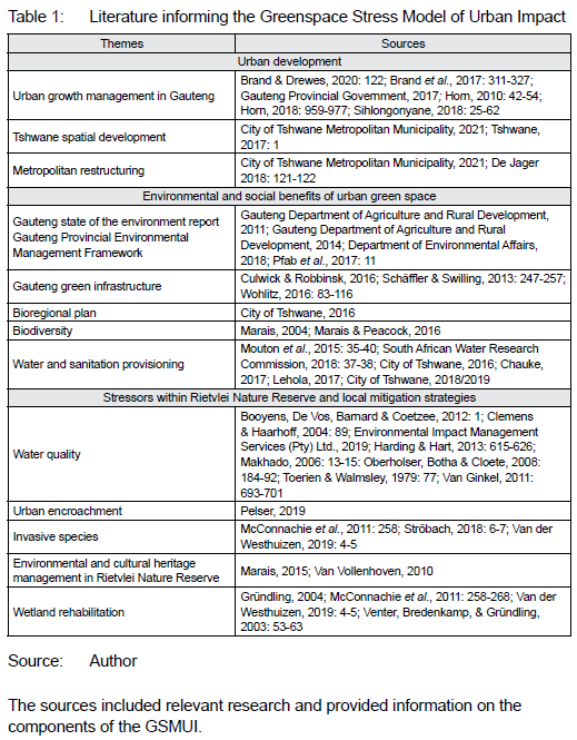
A selection of published research on the Rietvlei Nature Reserve and key policy documents were used to inform the GSMUI (Table 1).
4.2.4 Semi-structured interviews with key informants
Semi-structured interviews (n=18) conducted in 2016 created an initial understanding of the benefits, functions, and stressors, as well as an evaluation of the objectives of the Rietvlei Nature Reserve, as stipulated in the Ecological Management Plan (Marais, 2015). The purpose and objectives of the study were introduced to obtain consent prior to each interview.
The sources included relevant research and provided information on the components of the GSMUI.
Eighteen key informants were purposively selected through a snowballing method for the initial interviews (Creswell, 2014: 168). The sample was stratified to include expert knowledge from different perspectives.
• The development perspective included a town planner,
a property developer, a Geographic Information Systems (GIS) consultant, a legal representative for informal settlement, a soil scientist, an estate agent working adjacent to the reserve, as well as a consultant for bulk water provisioning to the Tshwane Metropolitan Municipality.
• The conservation and sense-of-place perspectives included the manager of the Rietvlei Nature Reserve, the director of Nature Conservation at the City of Tshwane, an Honorary Ranger, a conservationist, a wetland specialist, the chairperson of the NGO, Friends of Rietvlei, the owner of the Rietvlei Lion Tours, a former commodore of the Pretoria Sailing Club, and visitors to the reserve.
4.2.5 On-site face-to-face interviews with visitors to the Rietvlei Nature Reserve
On-site face-to-face interviews were conducted with visitors at the Marais Dam picnic site, the Coffee Shop, the camping and fishing area, and the dedicated area for the sailing club. The data-collection points were, therefore, spread over the reserve and not at points where the recreational experience could be interrupted.
The sample size for on-site face-to-face interviews was calculated based on primary data on visitors to the reserve during the period 20132014. This was the latest available data at the time when the fieldwork commenced. According to the Reserve Manager, the total number of visitors to the reserve in 2013-2014 was n=52 684. More visitors entered the reserve through the angling area (n=32 432) than through the main gate (n=20 252) (Reserve Manager, personal communication, 15 May 2015). The substantial number of visitors passing through the angling gate was ascribed to the overnight chalets, camping facilities, as well as organised events and activities of the Pretoria Sailing Club in this zone of the reserve. The average number of visitors per month to the Rietvlei Nature Reserve was n=52 684/12 = 4 390. A 5% sample would be regarded as acceptable for a representative sample. Thus, n=4 390 x 0,05 = 220. Making use of convenience sampling, only 181 interviews were conducted with visitors to the reserve who were available and willing to participate in the study (Creswell 2014: 168).
The interview schedule contained tick-box questions for the age category, where visitors are from, and for their connection to the reserve. Four open-ended questions were asked on experiences and benefits as well as concerns and stressors within the reserve.
The on-site interviews provided an additional advantage of allowing in-depth discussions with some of the visitors who were more involved and knowledgeable about issues such as eradication of invasive species, water quality, and feeding of game during drought seasons. Based on the face-to-face on-site interviews, potential stakeholders (key informants) were identified and invited to focus group meetings.
4.2.6 Focus group discussions
Focus group discussions were held in the Rietvlei Nature Reserve with representatives of different interest groups, namely Friends of Rietvlei (n=5), Honorary Rangers (n=5), birders and wildlife photographers (n=5), as well as the Pretoria Sailing Club (n=5).
The empirical results of the research were verified in a final focus group (10 July 2019).
Twenty key specialist participants who were identified in the previous phase of the research (see 4.2.5) were invited, but only 14 attended the focus group and 12 feedback forms were received. This focus group included representatives from a development perspective, and from conservation and sense-of-place perspectives. The participants evaluated, confirmed, and ranked the identified benefits and stressors within the Rietvlei Nature Reserve to determine a mean score each. The purpose of this focus group was to confirm both the benefits and the stressors identified in the semi-structured interviews, previous focus group discussions, and on-site face-to-face interviews, and to discuss strategies to deal with stressors.
4.3 Data analysis and interpretation
4.3.1 Observation
Various visits to the study area and participation in events and activities allowed for observation. A fact sheet was developed and used to structure field notes. Data was collected on the physical characteristics of the conservation area (landscape features, architecture, and scenery), accessibility, signage, safety, maintenance, attractions, visitor numbers, facilities used by visitors and activities in which they have participated, as well as environmental stressors. Observation was used to explore the study area, inform the data collection for on-site semi-structured interviews, and support interpretation of data from different sources.
4.3.2 Remote sensing
The South African land cover database of 1990 and 2014 was derived from equivalent remote sensing datasets and indicated land-cover change over a 25-year period (Department of Forestry, Fisheries and the Environment, 2023). The company Geoterralmage used the polygon shape file of the catchment area of the Rietvlei Dam to crop relevant sections from the database. Changes in the different land-use classes within the catchment area could, therefore, be derived from an Excel spreadsheet (De Jager 2020: 126-127). Land use in the catchment area for 2014 was visually interpreted from Landsat 8 false colour image (564).
4.3.3 Semi-structured interviews with key informants
The data-capturing tool of ten questions included closed as well as open-ended questions. Answers to all questions were captured on an Excel spreadsheet. Frequencies of options selected for closed questions were calculated and indicated as percentages. The management objectives of the reserve were ranked according to importance. The answers to open-ended questions were typed into the spreadsheet. Responses were thematically clustered in terms of economic, environmental, and social benefits of, and stressors within the reserve. Benefits as well as stressors within the Rietvlei Nature Reserve were identified and ecosystem services explored.
4.3.4 On-site face-to-face interviews with visitors to the Rietvlei Nature Reserve
A questionnaire with ten questions was used in the interviews to collect data. Visitor responses were noted on the questionnaire and then captured on an Excel spreadsheet. The values for options of closed questions were calculated, using frequencies and percentages. A process of manual coding was applied to answers to open-ended questions, in order to identify themes related to the meaning of the reserve for visitors, benefits and stressors experienced within the reserve, as well as personal experiences.
4.3.5 Focus group discussions
The purpose of the focus group discussions with the identified interest groups was to explore the role that each of the identified interest groups play within the Rietvlei Nature Reserve. The data was analysed by content analysis, identification of economic, environmental, and social benefits and stressors within the reserve.
In the final focus group with key informants, both the benefits and the stressors identified in previous phases of the research were confirmed and ranked, and mitigation strategies for stressors were recommended.
4.4 Limitations
A typical limitation of case-study research is that the findings cannot be generalised. The GSMUl was developed through a single case study. It could, however, be replicated in other green spaces. The GSMUl could be refined by quantifying identified benefits and stressors and analysing it through exploratory factor analysis. This will be especially beneficial in a comparative analysis of different urban green spaces.
5. FINDINGS
5.1 Observation
5.1.1 Form, function, and image within the reserve
Distinct areas within the reserve were differentiated based on function:
• The area around the dam wall, water-purification plant, and housing of employees may not be accessed by visitors but is important for conservation and water provisioning to the City of Tshwane.
• The camping and fishing area along the north-eastern side of the Rietvlei Dam has an important social function.
• The chalets on the north-western side of the Rietvlei Dam.
• In the designated area for the Pretoria Sailing Club, the focus is on active recreation through competitive canoeing and sailing, and the facilities were designed and built for that purpose. The sense of place of the demarcated sailing area, therefore, differs from that pertaining to the conservation area.
• The area at the main gate has administrative facilities, including offices, parking areas, a conference hall, and a lapa. These are used for storage, administration, education, meetings, and ad hoc events.
• The conservation area.
• Recreation areas: the picnic area at the Marais Dam, bird hides, big lapa, and the Coffee Shop.
• The lion camp and triangular camps are separated from the rest of the reserve by roads but have a buffer function protecting groundwater sources and runoff through grasslands.
• The Witkoppies farm was incorporated to protect the restored wetlands. It is not open to visitors for self-drive.
The architectural style of the bird hides; signage; the ablution facilities at the camping and fishing areas, as well as the buffalo-shaped climbing equipment in the children's play area at the Coffee Shop contribute to the sense-of-place image associated with conservation. Birders and photographers play a key role in creating an image of a nature-based recreation destination and in promoting the sense-of-place experiences in the reserve (Goodlet, 2017). Social media plays an important role in this regard.
Different types of visitors were identified including individual travellers, couples, groups of family and friends, special interest groups, volunteers participating in maintenance within the reserve, people attending ad hoc events such as corporate team building or birthday parties, and school learners on an excursion through the reserve. Nature-based recreation includes birding, fishing, camping, picnicking, sailing, game drives, and guided hikes.
5.1.2 Stressors observed within the reserve
The stressors identified in the literature were also observed in the reserve:
• Urban encroachment is evident. The Rietvlei Ridge Country Estate is adjacent to the main entrance gate and shares a section of the north-western border of the reserve. The Rietvlei View Country Estate to the eastern side, and the traffic on the Delmas Road and on the Dam Road are visible from within the conservation area (refer to Figure 2). Informal settlements are developing at the Moonlight Road to the south of the reserve.
• The researcher participated in initiatives to eradicate invasive species together with Friends of Rietvlei and observed that the wattle trees at the Marais Dam were replaced with indigenous species.
• Insufficient environmental awareness was reflected by the inappropriate behaviour of visitors and the limited information available to some visitors at the entrances. Guided hikes, game drives, events, and dissemination of information through printed matter and social media are used to improve environmental awareness.
• Volunteers play an important role in resolving recurring challenges with maintenance of the facilities in the reserve.
• Concerns in terms of water pollution as well as mitigation strategies were evident from meetings of the Hennops Catchment Management Forum as well as from visits to the water-purification plant.
Land use and land cover in the catchment area of the Rietvlei Dam influence the type of pollutants affecting water quality within the reserve.
5.2 Remote sensing results
The land-cover changes in the catchment of the Rietvlei Dam are presented in Table 2. The largest percentage of change within the said time period was evident in the residential land-use category, which increased from 4.3% to 6.0%, and in the smallholding category, which decreased from 12.3% to 11.5%. The economic opportunities emanating from changes in land use from smallholding to formal residential developments would most probably further enhance this trend in the future. There was a decline in dryland agriculture (-1.7%) and natural vegetation (-1%) and an increase in orchards (0.1%) and pivot irrigation (3.3%). This could influence the type of agricultural runoff entering the Rietvlei Dam.
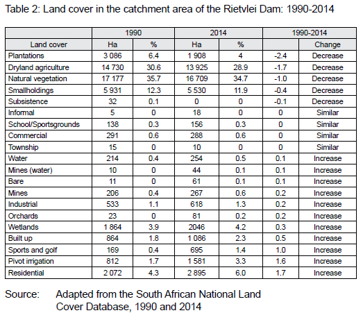
Urban-type land-use functions are increasing in what used to be a typically rural area in the urban fringe. Residential and retail developments have led to increased pressure on the already congested road infrastructure. The relative location of the Rietvlei Nature Reserve alongside a development and transport corridor could, therefore, contribute to long-term development pressures on the conservation area.
5.3 Semi-structured interviews with key informants' results
Semi-structured interviews provided evidence of urban pressures on the reserve. Population growth leads to increased need for space for housing, service provisioning, waste management, and infrastructure. Even though green space is incorporated in spatial planning, urban development exacerbates pressures from outside the reserve. The Dam Road (M31) runs through the northern section of the Rietvlei Nature Reserve and links suburbs such as Moreleta Park and Meadow Ridge in the eastern part of the former Pretoria to the development node at the Route 21 Business Park, Irene Village Mall, and the economic hub of Centurion (Figure 2). The planned upgrade of the Rietvlei Dam Road would not only strengthen the east-west corridor, but also improve the link between the R21 and the Delmas Road (Urban planner, personal communication, 14 November 2016). As higher order traffic boxes create opportunities for the development of a lower grid of road networks (Tshwane, 2017), this road-network development will probably further intensify the pressure of development on the Rietvlei Nature Reserve. The conservation status of the reserve as well as community engagement has, however, shielded the reserve from development.
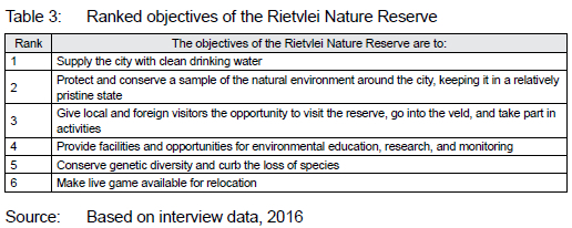
Stressors experienced within the reserve are managed through an ecological management plan which is a dynamic tool that is adapted according to the needs at the reserve (Reserve Manager, personal communication, 8 September 2016). Objectives of the Rietvlei Nature Reserve (Marais, 2015) were ranked in semi-structured interviews with key informants. Data was captured on an Excel spreadsheet and the result is presented in Table 3.
The Rietvlei Nature Reserve provides 41 million litres of drinking water per day to the City of Tshwane and it is expected that this would increase in future. The Rietvlei Nature Reserve provides important ecological services to the City of Tshwane. The functions and benefits of the Rietvlei Nature Reserve are not limited to recreational opportunities, but are also linked to the broader context. The following quote illustrates the nexus between development, conservation, and sense of place:
"When the link between conservation and water provisioning is not understood, the economics of having a conservation area in the city may not make sense. Budget priorities of the Tshwane Metropolitan Municipality could be a serious economic risk to the management of the Rietvlei Nature Reserve as there are insufficient immediate economic advantages in nature conservation. There is a risk that the nature reserve can be regarded as an economic burden to the local authority as it is not economically self-sustaining. Politicians need quick and visible results during their term of office. Building houses and providing electricity are tangible and measurable outcomes in the short term, while nature conservation is a long-term concept." (Director: Tshwane Nature Conservation, personal communication, 22 August 2016)
Conservation of the green infrastructure that supports water provisioning from the Rietvlei Nature Reserve is, therefore, vital. This is especially important, as the rapid development of formal and informal settlements in the catchment of the Rietvlei Nature Reserve implies serious challenges for the capacity of the Ekurhuleni Water Care Company (ERWAT) wastewater treatment facility and places increasing stress on the quality of water entering the reserve. The natural water-purification capacity of peatlands should, therefore, be protected.
5.4 On-site face-to-face interviews results
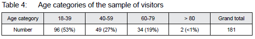
The vast majority (89.9%) of visitors were from the Gauteng province of South Africa, and more than half were from the City of Tshwane. Only 5.5% were international visitors and the remaining 4% were from South African provinces other than Gauteng. Most of the respondents (53%) were aged between 18 and 39 years and there were no participants under the age of 18 years (Table 4).
Sense of place is influenced by the physical characteristics (form), facilities and activities (function), as well as meaning a place has for an individual and his/her connection to it (Montgomery, 1998: 93).
The following themes were identified in answers to the open-ended question: What is special about Rietvlei?
• Tranquillity (silence and escape from the city)
• Proximity to the city
• Animals
• Birds
• Environment
• Safety
• Game drives
• Dam for fishing
• Camping/Picnic area
"We have Emerentia Dam and Walter Sisulu Botanical Gardens in Johannesburg, but we came here. Pedicured places and nature are not the same. There are different things to do and different types of people who go there." (Personal communication, Interview 5, 30 December 2016)
Participants could select more than one option to indicate their connection to the reserve. (Table 5). The indicators of connection were derived from Shamai (1991: 349-350).
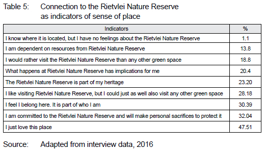
Despite a high frequency of willingness to make personal sacrifices, specific examples of actual personal sacrifices were limited to activities of the Friends of Rietvlei, the Honorary Rangers, the Pretoria Sailing Club, and the South African Hunters and Game Conservation Association. A sense of belonging and acknowledgement of the heritage also had high frequencies. In discussions, heritage was qualified as natural heritage rather than cultural heritage. The statement, "I like visiting the Rietvlei Nature Reserve, but I could just as well also visit any other green space" was selected by 28% of the participants, while only 18% of the participants indicated that they would rather visit Rietvlei than any other urban green space. Benefits of experiences of the natural environment within the city, therefore, influence the connection to the study area. Of the participants, 20% indicated that what happens in Rietvlei has personal implications for them, and 13.8% depended on resources from the reserve.
Many of the visitors did not know of any stressors within the reserve or indicated that it was their first visit, and they did not have any concerns. The following themes were indicated in the highest frequencies: maintenance, rhino poaching, fish not biting, the future of the reserve, and invasive species.
5.5 Focus group discussion results
From the focus groups discussions with the Pretoria Sailing Club, Honorary Rangers, Friends of Rietvlei, as well as birders and photographers, it was evident that volunteers play an important role in supporting the objectives of the reserve. Partnerships are, therefore, important. The interest groups do not only have local significance, for example Friends of Rietvlei are affiliated with the Wildlife and Environmental Society of South Africa (WESSA). Their annual programme includes regular work sessions for eradicating invasive species, the maintenance of facilities, the feeding of rhinos during winter, guided hikes, social activities, as well as ad hoc events to promote environmental awareness. The birders and photographers in Rietvlei are not a formal group; they share common interests and play an important role in the image of the reserve in social media, as well as in local and international publications. There are individual affiliations to photography and birding clubs. Honorary Rangers are part of SANParks, but they also contribute to conservation activities in the Rietvlei Nature Reserve. The Pretoria Sailing Club is not only for the 250 members, but it also has international significance for competitive canoeing and is beneficial for youth development and competitions between clubs (Former Commodore, personal communication, 5 November 2016). The sailing club is affiliated to South African Sailing (SAS) which is part of the World Sailing organisation and supports the National Sea Rescue Institute (NSRI). The Pretoria Sailing Club experienced implications of urban pressures to green space when the Centurion Canoe Club was incorporated, after the Centurion Lake was no longer suitable for paddling.
In the final focus group, the benefits and stressors that were identified in the interviews and stakeholder discussions were confirmed and ranked. Representatives from a development, conservation, and sense-of-place perspectives selected the ten most important benefits and stressors from the lists provided. Based on consensus in small group discussion, the top ten benefits (refer to Table 6) and stressors (refer to Table 7) were ranked.
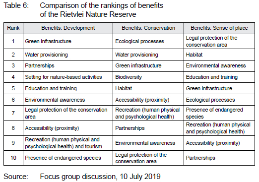
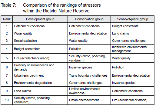
Based on the rankings in Table 6, it is evident that different priorities were given to the identified benefits from the development, conservation, and sense-of-place perspectives. A similar trend is evident from the rankings for stressors indicated in Table 7.
Awareness of stressors is important for sense of place. Only if they know and care enough, people would consider making personal sacrifices to protect the green space from stressors that could threaten the sustainability or future existence of the green space.
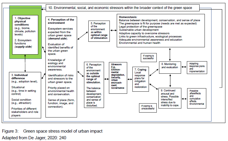
6. PROPOSED GREENSPACE STRESS MODEL OF URBAN IMPACT
The outline of the Stress Model of Urban Impact (Pacione, 2001: 401) was used as the basis for the GSMUI (Figure 3). However, in the Rietvlei case study, the study object was not individuals in the city but rather the urban green space and human perceptions pertaining to the associated benefits and stressors. While the objective characteristic of the green space is important, environmental perception is central to the identification of benefits, stressors, and mitigation strategies to deal with the stressors.
The linkages between the components in Figure 5 represent reciprocal relationships. The physical characteristics that influence perceptions of greenspaces reflect a linkage in one direction, but at the same time, the perceptions of the reserve and sense of place also influence the physical characteristics of the Rietvlei Nature Reserve. As is evident from the history of the nature reserve, perceptions of the environment have, over time, led to several attempts to change the boundaries of the reserve. Figure 3 should be read together with Table 8 that elucidates the different phases of the model.
Individual differences and priorities of stakeholders influence how the benefits of a green space are evaluated. Environmental perception is thus influenced by the ecosystem services expected from the green space as well as knowledge of ecosystem functions. Within a context of competing needs and approaches to environmental justice, environmental awareness influences decision-making about urban green space. The Rietvlei Nature Reserve is not only a recreational space for those who can access it, but it also provides green infrastructural services, of which water provisioning is the most important.
As in the GSMUI (Pacione, 2001: 401), there is homeostasis if there are not too many stressors evident within a green space. Should the balance between development, conservation, and sense of place be disturbed, however, stressors emerge that endanger the sustainability of the green space. Environmental perception and the priorities of individuals and stakeholders influence the identification of stressors as well as the selection of mitigation strategies. Sense of place is pivotal in the balance between development and conservation because the activities at the place, the image thereof, and the connection people have with the green space influence their decision-making.
Environmental awareness and sense of place influence stakeholders' perspectives regarding the benefits of, and the stressors for the Rietvlei Nature Reserve. It is, therefore, essential to promote awareness of the ecosystem services provided to protect the long-term sustainability of an urban green space. Information regarding the benefits of, and stressors within the reserve should be disseminated regularly to the relevant audiences to inform policies, practice, and local mitigation strategies.
Local response plans are developed for strategic environmental management. Sound environmental management practices are essential to improve the adaptive capacity of the green space to overcome stressors. Should the mitigation and restoration be successful, the balance can be restored. However, if the stressors intensify, it could lead to degradation and even threaten the future existence of the green space. This section of the GSMUI can be compared to the Tourism Area Life Cycle (Butler, 1980: 7), because the life cycle of urban green space is influenced by how the ecosystem services are protected (De Jager & Nicolau, 2020: 915). Continuous monitoring of response plans is essential. Should early warning signals be recognised, adaptive strategies could be devised timeously, so that the stressors do not become catastrophic.
Literature study should include local Integrated Development Programme documents, Spatial Development Frameworks on various levels of jurisdiction, any available scoping, Social Impact Assessments or Strategic Environmental Impact Assessment reports for the green space and surrounding area. Due to various environmental perceptions within the Global South, it is also important to identify stakeholders within the urban green space when evaluating local benefits and stressors and developing mitigation strategies. Sense of place could influence this process. Thus, a communication strategy should be developed to disseminate information on the ecosystem services provided by the conservation area. It should acknowledge the diversity of the significance that people associate with places and their attachment to such places.
7. CONCLUSION
Rapid urban development in the urban fringe area between Tshwane and Ekurhuleni leads to increased development pressures on the Rietvlei Nature Reserve. This is intensified by the relative location to road infrastructure and more specifically the Rietvlei Dam Road and the regional development activity corridor along the R21 between the Pretoria CBD and Ekurhuleni.
The importance of the Rietvlei Nature Reserve as a critical green infrastructural component of the City of Tshwane was evaluated from a geographical perspective. The nexus between development, conservation, and sense of place was explored. The literature study as well as the interpretation of guidelines for urban spatial development and maps informed the findings regarding implications and challenges of urban growth. The prominent functions of the reserve were explored through observation, semi-structured interviews, and focus groups. Benefits of this urban green space as well as stressors were identified, and possible mitigation strategies explored. It became evident that individual differences in social conditions, access to green space, and priorities of stakeholders influenced perceptions about the green space. Environmental awareness and connections to places influence the sense of place and meaning people have on how a green space can meet their needs.
The GSMUI was developed based on the framework provided by Pacione's stress model of urban impact (Pacione, 2001: 398-401) as well as Butler's life cycle of a tourist destination (Butler, 1980: 5-12). Both these models indicate the influence of stressors. According to Pacione, individuals have different social standings and settings that influence the stressors they experience as well as how they mitigate them. Not only the objective characteristics, but also individual environmental awareness and perceptions influence the selected coping mechanisms for stressors. Butler indicates that the way in which environmental degradation is mitigated influences the future characteristics of a tourist destination and whether it is restored or loses functionality as destination. Should a green space no longer be fit for purpose, the future of the reserve would be in jeopardy. It is, therefore, essential to promote the benefits of the reserve and apply relevant mitigation strategies to the identified stressors.
The Rietvlei Nature Reserve was originally declared a conservation area to protect the primary catchment area of the Rietvlei Dam and is included in open-space planning frameworks and green infrastructure on metropolitan and Gauteng provincial level. The natural purification of polluted water through the peatlands in the reserve supports the water provisioning from Rietvlei. Visitors to the reserve are not necessarily aware of the importance of wetlands for carbon sequestration or flood mitigation nor of the role of the Rietvlei Nature Reserve in water provisioning to the City of Tshwane.
Sense of place is influenced by awareness of environmental concerns and can play an important role in motivating people to participate and to make personal sacrifices to promote the conservation goals of an urban green space such as the Rietvlei Nature Reserve.
Ecological stressors such as loss of biodiversity, pollution, declining water quality, and increasing human needs are identified on a global level, but the mitigation thereof starts at the local level in places to which people are connected and about which they care. It is vital that both public and private entities protect the green space through well-articulated and practical conservation plans, as well as ongoing environmental awareness programmes. It remains important to protect urban green space, not only to provide the physical and psychological benefits of access to green space for recreation, but also to support ecological processes.
The GSMUI can be applied as a tool to integrate information from various sources for application to a particular urban green space. This tool can, therefore, be used to assist in the management of green space within fast-growing urban areas, especially in the Global South, where different perceptions about urban green space play a vital role in competition over land use. When applying the model, it should be refined to suit the context where it is applied and to explore and compare diverse types of urban green space. Finally, it is hoped that the GSMUI will contribute to a growing awareness of urban green spaces in the Global South, and possibly support contributions towards improved perceptions of these vital components of the natural environment in an urban setting.
ACKNOWLEDGEMENTS
A special word of thanks to Dr Jan Olivier and Prof. Melanie Nicolau, supervisors for my PhD from which this article was developed, and all who have participated in the journey. I also acknowledge the comments of anonymous reviewers and colleagues on previous versions of this article. This research was financially supported through a Masters and Doctoral Support Programme at Unisa. Maps were created by the Map Library of the Department of Geography, Unisa.
REFERENCES
ARTMANN, M., KOHLER, M., MEINEL, G., GAN, J. & IOJA, C.I. 2019. How smart growth and green infrastructure can mutually support each other - A conceptual framework for compact and green cities. Ecological Indicators, 96(2), pp. 10-22. https://doi.org/10.1016/j.ecolind.2017.07.001 [ Links ]
ATUMANE, A. & CABRAL, P. 2021. Integration of ecosystem services into land-use planning in Mozambique. Ecosystems and People, 17(1), pp. 165-177. https://doi.org/10.1080/26395916.2021.1903081 [ Links ]
BERNSTEIN, A. 2017. Health implications of biodiversity. In: Cockerham, W.C. (Ed.). International encyclopaedia of public health, 2nd edition. Singapore: Elsevier Inc., pp. 219-222. DOI: 10.1016/B978-0-12-803678-5.00033-3 [ Links ]
BOOYENS, S., DE VOS, D., BARNARD, S. & COETZEE, L. 2012. Gevallestudie om die invloed van die SolarBees sowel as dosering op die waterkwaliteit van die Rietvlei Dam watersuiweringsaanleg te evalueer. Suid-Afrikaanse Tydskrif vir Natuurwetenskap en Tegnologie, 31(1), Art. #282, 1 page. http://dx.doi.org/10.4102/satnt.v31i1.282 [ Links ]
BRAND, A. & DREWES, E. 2020. Structuring South Africa's national economic space: A regional corridor network model approach. Town and Regional Planning,77, pp. 120-136. http://dx.doi.org/10.18820/2415-0495/trp77i1.9 [ Links ]
BRAND, A., GEYER, H.S. & GEYER, H.S. Jr. 2017. Corridor development in Gauteng, South Africa. GeoJournal, 82(2), pp. 311-327. http://link.springer.com/journal/10708. https://doi.org/10.1007/s10708-015-9683-x [ Links ]
BUTLER, R.W. 1980. The concept of tourist area cycle of evolution: Implications for management of resources. Canadian Geographer, 24(1), pp. 5-12. https://doi.org/10.1111/j.1541-0064.1980.tb00970.x [ Links ]
CHAUKE, S. 2017. Basic service delivery challenges with regards to water and sanitation in Gauteng province: A case of City of Johannesburg and City of Tshwane Metropolitan Municipalities. Unpublished Master of Administration, University of South Africa. [ Links ]
CITY OF CAPE TOWN. 2012. Cape Town Spatial Development Framework: Statutory Report. Cape Town: City of Cape Town. [ Links ]
CITY OF TSHWANE. 2015. City of Tshwane: Nature Conservation. Available at: <http://www.tshwane.gov.za/sites/Tourism/NatureConservation/Pages/default.aspx> [Accessed: 29 May 2014]. [ Links ]
CITY OF TSHWANE. 2016. Bioregional Plan for the City of Tshwane. Available at: <http://www.tshwane.gov.za/sites/business/Bylaws/Draft%20ByLaws/City%20of%20Tshwane%20Bioregional%20Plan%20March%202016%20(EditedAll).pdf> [Accessed: 24 January 2019]. [ Links ]
CITY OF TSHWANE. 2018/2019. Draft review of the 2017/21 integrated development plan: Annexure A. Available at: <http://www.tshwane.gov.za/sites/Council/Ofiice-Of-The-Executive-Mayor/Pages/Integrated-Development-Planning.aspx.> [Accessed: 15 October 2018]. [ Links ]
CITY OF TSHWANE METROPOLITAN MUNICIPALITY. 2021. City of Tshwane Metropolitan Spatial Development Framework, 2030. Tshwane: City of Tshwane. [ Links ]
CLEMENS, M. & HAARHOFF, J. 2004. Practical experiences with granular activated carbon (GAC) at the Rietvlei Water Treatment Plant. Water SA, 30(1), pp. 89-96. DOI: 0.4314/wsa. v30i1.5031 [ Links ]
CRESWELL, J.W. 2014. Research design qualitative, quantitative, and mixed methods approaches. 4th edition. Thousand Oaks, CA: Sage Publications. [ Links ]
CULWICK, C. & ROBBINSK, K, 2016. A framework for a green infrastructure planning approach in Gauteng City Region. GCRO Research Report #No.4. Johannesburg: Gauteng City Region Observatory. DOI: 10.13140/RG.2.2.29910.24649 [ Links ]
DE JAGER, A.E. 2018. Boundaries and watersheds with reference to the Rietvlei Nature Reserve (City of Tshwane). Extended abstract. Suid-Afrikaanse Tydskrif vir Wetenskap en Tegnologie, 37(1), pp. 121-122. [ Links ]
DE JAGER, A.E. 2020. A geographical interpretation of the interplay between development, conservation, and sense of place of urban greenspace in Rietvlei Nature Reserve, Tshwane, South Africa. Unpublished PhD (Geography). University of South Africa. [ Links ]
DE JAGER, A.E. & NICOLAU, M.D. 2020. Opening the door for wider application of the tourism area life cycle model with application to the Rietvlei Nature Reserve, Tshwane, South Africa. African Journal of Hospitality, Tourism and Leisure, 9(6), pp. 912-929. https://doi.org/10.46222/ajhtl.19770720-59 [ Links ]
DEPARTMENT OF ENVIRONMENTAL AFFAIRS. 2018. Government Gazette No. 14173. Schedule: Standard and associated excluded activities for the implementation of the Gauteng Provincial Environmental Management Framework. Pretoria: Republic of South Africa. [ Links ]
DEPARTMENT OF FORESTRY, FISHERIES AND THE ENVIRONMENT. 2023. SA national land-cover datasets. Available at: <https://egis.environment.gov.za/sa_national_land_cover_datasets> [Accessed: 24 March 2023]. [ Links ]
DE SATGÉ, R. & WATSON, V. 2018. Urban planning in the Global South: Conflicting rationalities in contested urban space. London: Palgrave MacMillan. https://doi.org/10.1007/978-3-319-69496-2 [ Links ]
DI MARINO, M., TIITU, M., LAPINTIE, K. VIINIKKA, A. & KOPPEROINEN, L. 2019. Integrating green infrastructure and ecosystem services in land-use planning. Results from two Finnish case studies. Land Use Policy, 82, pp. 643-656. 10.1016/j.landusepol.2019.01.007 [ Links ]
DU TOIT, M.J., CILLIERS, S.S., DALLIMER, M., GODDARD, M. GUENAT, S. & CORNELIUS, S.F. 2018. Urban green infrastructure and ecosystem services in sub-Saharan Africa. Landscape and Urban Planning, 180, pp. 249-261. https://doi.org/10.1016/j.landurbplan.2018.06.001 [ Links ]
ENVIRONMENTAL IMPACT MANAGEMENT SERVICES (PTY) LTD. 2019. Wetland rehabilitation environmental and maintenance management programme Rietvlei Catchment. City of Ekurhuleni: Ekurhuleni Metropolitan Municipality. [ Links ]
FISHER. R. 2017. Ekurhuleni Metropolitan Municipality wetland report. Local action for biodiversity (LAB): Wetlands South Africa. Ekurhuleni: ICLEI Local Governments for Sustainability - African Secretariat. [ Links ]
FRIENDS OF RIETVLEI. 2017. Chairman's report. Friends of Rietvlei Newsletter, December. City of Tshwane. [ Links ]
FUGGLE, R.F.& RABIE, M.A. 1992. Environmental management in South Africa. Cape Town. Juta & Co. Ltd. [ Links ]
GAUTENG DEPARTMENT OF AGRICULTURE AND RURAL DEVELOPMENT. 2011. Gauteng State of the Environment Report - 2011. Johannesburg: Gauteng Provincial Government. [ Links ]
GAUTENG DEPARTMENT OF AGRICULTURE AND RURAL DEVELOPMENT. 2014. Technical report for the Gauteng Conservation Plan. Tshwane: Directorate Nature Conservation, Technical Services. [ Links ]
GAUTENG PROVINCIAL GOVERNMENT. 2017. Gauteng spatial development framework 2030. Johannesburg: Gauteng Province. [ Links ]
GIRMA, Y., TEREFE, H. & PAULEIT, S. 2019. Urban green space use and management in rapidly urbanizing countries: The case of emerging towns of Oromia special zone surrounding Finfinnee, Ethiopia. Urban Forestry and Urban Greening, 43, pp. 139-159. DOI: 10.1016/J.RSASE.2018.10.019 [ Links ]
GOODLET, W. 2017. Rietvlei eGuide. Available at: <https://willgoodlet.com/rietvlei-nature-reserve/>. [Accessed: 26 January 2019]. [ Links ]
GRÜNDLING, A.T. 2004. Evaluation of remote sensing sensors for monitoring rehabilitated wetlands. Pretoria: University of Pretoria. [ Links ]
HARDING, W.R. & HART, R.C. 2013. Food-web structure in the hypertrophic Rietvlei Dam based on stable isotope analysis: Specific and general implications for reservoir biomanipulation. Water SA, 39(5), pp. 615-626. DOI: 10.4314/wsa.v39i5.5 [ Links ]
HAUSMANN, A., SLOTOW, R., BURNS, J.K. & DIMINI, E. 2015. The ecosystem service of sense of place: Benefits for human well-being and biodiversity conservation. Environmental Conservation, 43(2), pp. 117-127. DOI: 10.1017/S0376892915000314 [ Links ]
HORN, A. 2010. Telling stories - A history of growth management strategies in the Gauteng province (South Africa). European Spatial Research and Policy, 17(2), pp. 42-54. DOI: 10.2478/s10105-010-0009-1 [ Links ]
HORN, A. 2018. The history of urban growth management in South Africa: Tracking the origin and current status of urban edge policies in three metropolitan municipalities. Planning Perspectives, 34(6), pp. 959- 977. https://doi.org/10.1080/02665433.2018.1503089 [ Links ]
LEHOLA, P. 2017. The state of basic service delivery in South Africa: An in-depth analysis of the community survey: 2016 data. Report No. 03-01-22 2016, City of Tshwane: Statistics South Africa. [ Links ]
LINDLEY, S., PAULEIT, S., YESTHITELA, K., CILLIERS, S. & SHACKLETON, C. 2018. Rethinking urban green infrastructure and ecosystem services from the perspective of sub-Saharan African cities. Landscape and Urban Planning, 180, pp. 328-338. https://doi.org/10.1016/j.landurbplan.2018.08.016 [ Links ]
MAKHADO, R. 2006. Rietvlei wetland and the role it plays in the reduction of pollutants from sewage wastewater. SANCOR Newsletter,183, pp. 13-15. [ Links ]
MARAIS, R. 2004. A plant ecological study of the Rietvlei Nature Reserve, Gauteng province. Bloemfontein: Department of Animal Wildlife and Grassland Studies, University of the Free State. [ Links ]
MARAIS, R. 2015. An ecological management plan for the Rietvlei Nature Reserve. Official report. City of Tshwane Metropolitan Municipality. [ Links ]
MARAIS, E. & PEACOCK, F. 2016. The Chamberlain guide to birding: Gauteng. Centurion: Mirafra Publishing. [ Links ]
MASTERSON, V.A., STEDMAN R.J., ENQVIST, J., TENGÖ M., GIUSTI, M. & WAHL, D. 2017. The contribution of sense of place to social-ecological systems research: A review and research agenda. Ecology and Society, 22(1), pp. 49-54. https://doi.org/10.5751/ES-08872-220149 [ Links ]
MCCONNACHIE, A.J., RETIEF, E., HENDERSON, L. & MCKAY, F. 2011. The initiation of a biological control programme against pompom weed, Campulocliniummacrocephalum (Less.) DC. (Asteraceae), in South Africa. African Entomology, 19(2), pp. 258-268. DOI: 10.4001/003.019.0217 [ Links ]
MENSAH, C.A. 2014. Destruction of urban greenspaces: A problem beyond urbanisation in Kumasi City (Ghana). American Journal of Environmental Protection, 3(1), pp. 1-9. DOI: 10.11648/j.ajep.20140301.11 [ Links ]
MILLENNIUM ECOSYSTEM ASSESSMENT. 2005. Ecosystems and human well-being. Washington, DC: Island Press. [ Links ]
MONTGOMERY, J. 1998. Making a city: Urbanity, vitality and urban design. Journal of Urban Design 3(1), pp. 93-116. doi.org/10.1080/13574809808724418 [ Links ]
MOUTON, F., LOUBSER, E., TALANDA, C., VAN ROOYEN, P. & CERENIO, T. 2015. City of Tshwane Water Resources Master Plan. Civil Engineering, 23(5), pp. 35-40. [ Links ]
NAGAR, D. 2006. Environmental psychology. New Delhi: Concept Publishing Company. [ Links ]
NDUBISI, F.O. 2014. The ecological design and planning reader. Washington: Island Press. https://doi.org/10.5822/978-1-61091-491-8 [ Links ]
OBERHOLSER, P.J., BOTHA, A.M. & CLOETE, T.E. 2008. Biological and chemical evaluation of sewage water pollution in the Rietvlei Nature Reserve wetland area, South Africa. Environmental Pollution, 156(1), pp. 184-192. DOI: 10.1016/j.envpol.2007.12.028 [ Links ]
PACIONE, M. 2001. Urban geography - A global perspective. London: Routledge. https://doi.org/10.4324/9780203454626 [ Links ]
PACIONE, M. 2003. Urban environmental quality and human wellbeing - A social geographical perspective. Landscape and Urban Planning 65(1-2), pp. 19-30. DOI: 10.1016/S0169-2046(02)00234-7 [ Links ]
PASQUINI, L. & ENQVIST, J.P. 2019. Green infrastructure in African cities. Report for Cities' Support Programme. African Centre for Cities. Cape Town. [ Links ]
PELSER, A.J. 2019. Phase 1 HIA repor for a proposed Alling station (Rietvlei Extension 6) on the remaining portion of portion 1 of the farm Witkoppies 393JR, east of the Rietvlei Dam Nature Reserve, City of Tshwane, Gauteng. Report: APAC019/17. Pretoria. Bokamoso Landscape Architects and Environmental Consultants CC. [ Links ]
PFAB, M.F., COMPAAN, P.C., WHITTINGTON-JONES, C.A., ENGELBRECHT, I., DUMALISILE, L., MILLS, L. et al. 2017. The Gauteng Conservation Plan: Planning for biodiversity in a rapidly urbanising province. Bothalia 47(1), a2182:11 https://doi.org/10.4102/abc.v47i1.2182 [ Links ]
RISHI, P. & KHUNTIA, G. 2012. Urban environmental stress and behavioral adaptation in Bhopal City of India. Urban Studies Research. Article number: 635061, pp. 1-9. https://doi.org/10.1155/2012/635061 [ Links ]
RSA (REPUBLIC OF SOUTH AFRICA) 1998. National Environmental Management Act, No. 107 of 1998. South Africa: Government Printer. [ Links ]
RSA (REPUBLIC OF SOUTH AFRICA). 2000. Local Government: Municipal Systems Act 32 of 2000. South Africa: Government Printer. [ Links ]
RSA (REPUBLIC OF SOUTH AFRICA). 2013. Spatial Planning and Land Use Management Act (SPLUMA) Act 16 of 2013. South Africa: Government Printer. [ Links ]
SCHÄFFLER, A. & SWILLING, M. 2013. Valuing green infrastructure in an urban environment under pressure - The Johannesburg case. Ecological Economics, 86, pp. 246-257. DOI: 10.1016/j.ecolecon.2012.05.008 [ Links ]
SEIWERT, A. & RÖßLER, S. 2020. Understanding the term green infrastructure: Origins, rationales, semantic content, and purposes as well as its relevance for application in spatial planning. Land Use Policy, 97, pp. 104785. https://doi.org/10.1016/j.landusepol.2020.104785 [ Links ]
SHAMAI, S. 1991. Sense of place: An empirical measurement. Geoforum, 22(3), pp. 347-358. DOI: 10.1016/0016-7185(91)90017-K [ Links ]
SIHLONGONYANE, M.F. 2018. The economic drivers of urban change in the Gauteng City Region: Past, present and future. In: Cheruioyt, K. (Ed.). The changing space economy of city regions. Cham: Springer, pp. 25-62. DOI: 10.1007/978-3-319-67483-4_2 [ Links ]
SOUTH AFRICAN WATER RESEARCH COMMISSION (WRC). 2018. Rietvlei Dam - Faithful supplier of water to the capital - Last word. Water Wheel, 17(1), pp. 37-38. [ Links ]
STATISTICS SOUTH AFRICA. 2018. Provincial Profile: Gauteng. [Community Survey 2016]. Report number 03-01-09. Provincial profile, City of Tshwane: Statistics South Africa. [ Links ]
STRÖBACH, M. 2018. Progress: Alien invasive plants program. Friends of Rietvlei Newsletter April 2018, pp. 6-7. [ Links ]
TOERIEN, D.F. & WALMSLEY, R.D. 1979. The chemical composition of the Upper Hennops River and its implications on the water quality of the Rietvlei Dam. Water SA, 5(2), pp. 77-89. [ Links ]
TSHWANE. 2017. Spatial Development Framework. Zone 6. City of Tshwane Metropolitan Municipality. [ Links ]
VAN DER WESTHUIZEN, L. 2019. Pompom weed (campulocliniummacrocephalum): update on biological control. SAPIA News, 4-5. [ Links ]
VAN GINKEL, C.E. 2011. Eutrophication: Present reality and future challenges for South Africa. Water SA, 37(5), pp. 693-701. https://doi.org/10.4314/wsa.v37i5.6 [ Links ]
VAN VOLLENHOVEN, A.C. 2010. A cultural heritage management plan for the Rietvlei Nature Reserve, City of Tshwane. Tshwane: Archaetnos Culture and Cultural Resource Consultants. [ Links ]
VENTER, C.E., BREDENKAMP, G.J. & GRÜNDLING, P.L. 2003. Short-term vegetation change on rehabilitated peatland on Rietvlei Nature Reserve. Koedoe, 46(1), pp. 53-63. DOI: https://doi.org/10.4102/koedoe.v46i1.46 [ Links ]
WILLIAMS, D.R. & STEWART, S.A. 1998. Sense of place: An elusive concept that is finding its home in ecosystem management. Journal of Forestry, 96(5), pp. 18-23. [ Links ]
WOHLITZ, E. 2016. Bring nature back to the city. Pretoria: Briza. [ Links ]
WORLD HEALTH ORGANIZATION. 2016. Urban greenspaces and health. Copenhagen: WHO Regional Office for Europe. [ Links ]
YIN, R. 2012. Applications of case study research. 3rd edition. Los Angeles: SAGE. [ Links ]
ZHAO, Y., LIU, Z. & WU, J. 2020. Grassland ecosystem services: A systematic review of research advances and future directions. Landscape Ecology, 35, pp. 793-814. DOI: 10.1007/s10980-020-00980-3 [ Links ]
Received: November 2022
Peer reviewed and revised: January 2023
Published: June 2023
* The author(s) declared no potential conflicts of interest with respect to the research, authorship, and/or publication of this article

