


Serviços Personalizados
Artigo
 Inglês (pdf)
 Artigo em XML
 Referências do artigo
Indicadores

Links relacionados
-
 Citado por Google
 -
 Similares em Google
Compartilhar

 Permalink
Town and Regional Planning
versão On-line ISSN 2415-0495
versão impressa ISSN 1012-280X
Town reg. plan. (Online) vol.81 Bloemfontein 2022
http://dx.doi.org/10.18820/2415-0495/trp81i1.6
RESEARCH ARTICLE
Land acquisition processes in flood-prone informal settlements in Dar es Salaam: A rhetoric revealing land governance
Grondverkrygingsprosesse in vloedgevoelige informele nedersettings in dar es salaam: 'n retoriek wat grondbestuur blootstel
Mekhoa ea khutliso ea mobu metseng ea sa reroang e ahiloeng libakeng tse tlokotsing ea likhohola naheng ea dar es salaam: puo e senolang puso ea mobu
Emmanuel KemwitaI; Wilbard KombeII; Huba NgulumaIII; Iddi MwanyokaIV
ISpatial Planning and Social Sciences, Ardhi University, PO Box 35176, Dar es Salaam, Tanzania. Phone: +255718917156, email: fares.kemwita@gmail.com, ORCID: https://orcid.org/0000-0002-6173-541X
IIInstitute of Human Settlement Studies, Ardhi University, PO Box 35176, Dar es Salaam, Tanzania. Phone: +255754554126, email: Kombewilbard@yahoo.com, ORCID ID: https://orcid.org/0000-0001-9117-9496
IIIInstitute of Human Settlement Studies, Ardhi University, PO Box 35176, Dar es Salaam, Tanzania. Phone: +255786022029, email: huba8660@yahoo.com, ORCID ID: https://orcid.org/0000-0001-7875-8792
IVGeography & Environmental Studies, University of Dodoma, PO Box 395, Dodoma, Tanzania. Phone: +255683511469, email: imwanyoka@gmail.com, ORCID ID: https://orcid.org/0000-0002-2248-6932
ABSTRACT
Acquisition of land in flood-prone informal settlements is restricted by land-use policies, laws, and regulations in many countries, including Tanzania. Due to rapid urbanisation trends, coupled with growing urban planning deficiencies, many residents, particularly in the low-income group, have resorted to settling in flood-prone informal settlements. This article provides a rhetoric exposé to land governance by exploring the processes that land seekers go through to acquire building land (sites). This includes flood-prone land in informal settlements in Dar es Salaam, despite prohibition by land-use legislation. The study employed a case study design where quantitative and qualitative data were collected, using household questionnaires, key informant interviews, and focus-group discussions. Msasani Bonde la Mpunga, a flood-prone settlement in Dar es Salaam, was selected as a case study area to investigate the processes and actors involved. Results showed that most of the landowners in flood-prone areas of Msasani Bonde la Mpunga acquired land parcels informally after they moved into the city from various parts of the country. Approaches and processes of acquiring land were gone through, using social connections with relatives and friends living in the area, engaging brokers, and obtaining verbal or written selling transfer agreements from ward officials. Some encroached or invaded vacant land. Gradually, building structures emerged, although initially, invaders pretended to put up temporary dwellings. The few who inherited land did not undergo similar processes of acquiring land directly. This article concludes that the processes through which land seekers acquire building land, despite being flood-prone areas, are fuelled by weak governance. Government measures are often top-down and reactive instead of proactive. The article recommends rethinking land-governance efforts that entail bottom-up interventions with substantive involvement in decision-making processes. These should involve communities in the co-production of appropriate land-governance regulatory measures in flood-prone informal settlements.
Keywords: Informal settlements, flood risk, land acquisition, land governance, regulatory frameworks
OPSOMMING
Die verkryging van grond in vloedgevoelige informele nedersettings word beperk deur grondgebruikbeleide, wette en regulasies in baie lande, insluitend Tanzanië. As gevolg van vinnige verstedelikingstendense tesame met groeiende stedelike beplanningstekorte, het baie inwoners, veral in die lae-inkomstegroep, hulle in vloedgevoelige informele nedersettings gevestig. Hierdie artikel bied 'n retoriek wat grondbestuur blootstel deur die prosesse te ondersoek waardeur grondsoekers gaan om bougrond (persele) te bekom. Dit sluit in vloedgevoelige grond in informele nedersettings in Dar es Salaam, ondanks die verbod daarop deur grondgebruikwetgewing. Die studie het 'n gevallestudie-ontwerp gebruik waar kwantitatiewe en kwalitatiewe data ingesamel is deur huishoudelike vraelyste, sleutel-informant-onderhoude en fokusgroepbesprekings te gebruik. Msasani Bonde la Mpunga, 'n vloedgevoelige nedersetting in Dar es Salaam, is gekies as 'n gevallestudie-area om die prosesse en rolspelers wat betrokke is te ondersoek. Resultate het getoon dat meeste van die grondeienaars in vloedgevoelige gebiede van Msasani Bonde la Mpunga stukkies grond informeel bekom het nadat hulle uit verskeie dele van die land in die stad ingetrek het. Benaderings en prosesse van die verkryging van grond was gedoen deur die gebruik van sosiale verbintenisse met familie en vriende wat in die area woon, makelaars en mondelinge of skriftelike verkoopsoordragooreenkomste van wyksamptenare. Sommige het leë grond binnegedring. Geleidelik het boustrukture ontstaan, hoewel indringers aanvanklik voorgegee het dat hulle tydelike wonings oprig. 'n Paar wat grond geërf het, het nie soortgelyke prosesse ondergaan om grond direk te bekom nie. Hierdie artikel kom tot die gevolgtrekking dat die prosesse waardeur grondsoekers bougrond bekom ten spyte daarvan dat dit vloedgevoelige gebiede is, aangevuur word deur swak bestuur. Heroorweging van grondbestuurpogings wat onder-na-bo-ingrypings behels met substantiewe betrokkenheid by besluitnemingsprosesse word aanbeveel. Dit behoort gemeenskappe te betrek by die ko-produksie van toepaslike grondbestuur regulatoriese maatreëls in vloedgevoelige informele nedersettings.
Ho nkuoa ha mobu metseng e sa reroang e anngoeng ke likhohola ho thibetsoe ke maano, melao le melaoana ea tsebeliso ea mobu linaheng tse ngata, ho kenyeletsoa Tanzania. Ka lebaka la mekhoa e potlakileng ea ho aha litoropong, hammoho le bofokoli bo ntseng bo eketseha ba moralo oa litoropo, baahi ba bangata, haholo-holo ba nang le meputso e tlase, ba se ba ikhethetse ho ea lula metseng e sa reroang e anngoeng ke likhohola. Sengoliloeng sena se fana ka tlhaloso e hlakileng ea puso ea mobu ka ho hlahloba methati eo batho ba batlang mobu ba fetang ho eona ho fumana sebaka sa ho aha. Sena se kenyelletsa mobu o kotsing ea likhohola metseng e sa reroang Dar es Salaam, leha sena se thibetsoe ke molao oa tsebeliso ea mobu. Phuputso e sebelisitse moralo oa thuto-pale moo ho neng ho bokelloa lintlha tsa bongata le tsa boleng, ho sebelisoa lipotso tsa malapa, lipuisano tsa litsebi tse ka sehloohong, le lipuisano tsa lihlopha. Msasani Bonde la Mpunga, sebaka sa bolulo se kotsing ea likhohola Dar es Salaam, se khethiloe e le sebaka sa boithuto ho fuputsa lits'ebetso le batsoantsisi ba amehang. Liphetho li bonts'itse hore boholo ba beng ba litsa libakeng tse anngoeng ke likhohola tsa Msasani Bonde la Mpunga ba ile ba fumana litsa ka mokhoa o sa reroang kapa o molaong hore ba fallele toropong ho tsoa libakeng tse fapaneng tsa naha. Mekhoa ea ho fumana mobu e ile ea etsoa, ho sebelisoa likamano tsa sechaba le beng ka bona le metsoalle e lulang sebakeng seo, ho buisana le barekisi, le ho fumana litumellano tsa phetisetso ea thekiso ka molomo kapa ka mongolo ho liofisiri tsa lebatooa. Ba bang ba ile ba aha libakeng tse se nang batho kapa metse. Hanyane ka hanyane, mehaho e ile ea hlaha, le hoja qalong bahlaseli ba ne ba iketsa eka ba haha matlo a nakoana. Ba seng bakae ba ileng ba sieloa lefa la mobu ha baa ka ba etsa mekhoa e tsoanang ea ho fumana litsa ka kotloloho. Sengoliloeng sena se phethela ka hore puso e fokolang e hlohlelletsa litsela tseo batho ba batlang mobu ba fumanang litsa tsa meaho ka tsona, ho kenyeletsa le libakeng tse anngoeng ke likhohola. Hangata mekhoa le mehato ea 'muso e thoma holimo pusong e leba tlase sechabeng. Hape ha ena tjantjello ea ho tlisa phetoho pele ho eba le mathata kapa litla morao. Sengoliloeng sena se khothaletsa ho nahanoa bocha matsapa a taolo ea mobu a kenyelletsang liqeto tse etsoang ho tloha tlase sechabeng ho ea holimo pusong. Tsena li lokela ho kenyelletsa sechaba tlhahisong e kopanetsoeng ea mehato e nepahetseng ea taolo ea mobu metseng e sa reroang e bile e anngoe ke likhohola.
1. INTRODUCTION
Over half of the world's population (56%) lives in urban areas, with over seven residents out of ten in the world live in developing countries (UN-Habitat, 2022: 4). This figure is projected to reach a 68% increase at the annual rate of 65 million residents by 2050 (UN-Habitat, 2016: 38). Projections show that, by 2050, over 2.5 billion people will add to the urban population, with nearly 90% of this increase expected in Africa and Asia (United Nations, 2019: 10). This UN report reveals further that this is due to urbanisation trends, a gradual shift of residences from rural to urban areas, and a general growth of the world's population (United Nations, 2019: 10). This increase in urban population has resulted in, among others, urbanisation under poverty, inequality, and expansion of informal settlements (UN-Habitat, 2014: 13; Zhang, 2016: 8). Informal settlements experience severe flooding with significant adverse impact, due to poor quality of construction and high population density (De Risi et al., 2013).
Dar es Salaam City in Tanzania has been affected by flood events. For several decades, floods have caused significant impacts on city residents. For instance, the El Nino-related floods of 1997/1998 led to the loss of lives, and the destruction of buildings, properties, and livelihoods (John, Magina & Kemwita, 2019: 401). According to Anande and Luhunga (2019: 421), notable flooding in Dar es Salaam City includes that of December 2011, 2013, 2014, and 2019, which destroyed infrastructure and building properties worth 7.5 million Tanzanian shillings (2,550 USS).1 As a result, the Tanzania Government spent roughly 1.83 billion Tanzanian shillings to rescue and relocate thousands of vulnerable city dwellers in various low-lying areas (Anande & Luhunga, 2019: 421). In 2019, Kinondoni, Ilala, and Temeke (municipalities of Dar es Salaam City) were affected by floods that caused damage to properties, destroyed livelihoods, put people at risk of diseases, and left 25 people homeless (IFRC, 2019: 1). Dar es Salaam's current master plan (2016-2035) shows that the city suffers severe floods every year, with thousands of urban residents affected. For instance, over 400 households, equal to more than 2,000 people, are displaced every year by flood events in Dar es Salaam City. In addition, severe damages are caused, and property losses are experienced (URT, 2016: 41).
Following notable impacts of flooding, the Tanzania Government has put in place regulatory frameworks (land-use policies, laws, regulations, and guidelines) that govern flood-prone informal settlements. These include the National Land Policy of 1997, the National Human Settlements Development Policy of 2000, the Land Act No. 4 of 1999, and the Urban Planning Act of 2007 (URT, 1997; URT, 2000; URT, 1999; URT, 2007). These regulatory frameworks declare development restrictions on land in areas susceptible to hazards such as flooding. However, they recognise the contribution of informal settlements in solving housing problems (Sakijege, 2019: 316).
Scholars (Tas et al., 2013: 443; Nsorfon, 2014: 22) indicate that hardly any attention is paid to spearheading existing regulatory frameworks governing flood-prone informal settlements. Urban planning and management of land in flood-prone informal settlements across African cities, particularly in regions south of the Sahara, are inadequate and have remained a challenge (Adelekan et al., 2015: 34-38; Amoako, 2016: 13-14). Other studies (Mbura, 2014: 59; Williams et al., 2019: 159-160) note that ineffective disaster-management plans provide loopholes for residents, particularly those with low income, to assume that flood-prone areas are no-man's-land and deserve habitations. Parnell (2015: 351-352) adds that the inability of the city authority management to accommodate a fast-growing population in decent circumstances elucidates why it is difficult to implement land-use regulatory frameworks in disaster areas, including flood-prone informal settlements.
Despite a growing body of literature on flood-prone informal settlements in Tanzania and Dar es Salaam, in particular, there is a paucity of research and inadequate knowledge regarding the processes that urban land seekers undergo to acquire land and construct houses in flood-prone areas, despite restrictive legislation. This is the rationale for conducting this research in Dar es Salaam City, with a specific focus on the flood-prone area of Msasani Bonde la Mpunga informal settlement. The knowledge obtained from this study is intended to build on the existing literature and provide policy recommendations and actions for resilient flood governance of flood-prone informal settlements. Essentially, the article aims to understand and provide insights into urban land seekers' processes to acquire building land in flood-prone informal settlements. To do so, the article traces the origin of the residents, land acquisition practices, as well as processes, ownership, and enforcement.
2. LITERATURE REVIEW
It is important to review the vulnerability of informal settlements and the state of land governance and policies, in order to understand the processes that urban land seekers go through to acquire land in flood-prone informal settlements,
2.1 Global urban areas' vulnerability to natural hazards
According to Salami, Von Meding and Giggins (2017: 1), in the recent past, the frequency of disasters, specifically large-scale floods, has increased worldwide, causing casualties, destruction of property, and severe economic loss. Studies worldwide indicate that floods account for over 55% of all fatalities and that nearly 2.5 billion people are affected (Vojinovic, 2015; Suhr & Steinert, 2022: 6). Along the same line of argument, Kasim et al. (2021) assert that the world is increasingly characterised by uncertainty, complexity, and rapid change that raises the vulnerability to potential disasters. The authors argue further that the situation is worse in countries where governments cannot manage land use and development in rapidly growing towns and cities. The situation becomes challenging because of the increased concentration of population in urban areas and the socio-economic and spatial vulnerabilities that make urban centres more susceptible to the risk of being severely affected by natural hazards (Gencer, 2013).
The foregoing arguments are echoed by John (2020: 68), who notes that the vulnerability of the urban poor to natural hazards, particularly in the Global South, is aggravated by rapid urbanisation and climate change, especially in cities of developing countries, where a large number of the population lives in informal settlements. In the African context, it is argued that cities are increasingly overstretched to cater for high-density populations with inadequate infrastructure and basic services (Salami et al., 2017: 6; Ramiaramanana & Teller, 2021: 17). These authors add that this state of affairs may aggravate flood mortality, given the high percentage of informal settlements with corresponding substandard houses, inadequate protection of assets, and development of unhealthy urban growth. Moreover, the vast majority of urban residents have less capacity and few resources to mitigate or recover from shocks. On the positive side, however, discussing informal settlements and urban development in Ghana, Agyabeng et al. (2022) argue that, although a diverse negative overtone is associated with informal settlement dwellers and the myriad of challenges they face, they significantly contribute to economic and urban development in Accra, through revenue generation, job creation, and the provision of labour. Such observations suggest that, if judiciously involved in urban planning and decision-making processes, dwellers of flood-prone informal settlements can significantly contribute to informing relevant policy processes, especially when their capacities and assets are enhanced (Nassar & Elsayed, 2018: 5). Regardless of the contributions that informal settlements have shown, especially in solving housing problems, some scholars view them as settlements that predominantly follow the urban forms of African cities (Kihato et al., 2013: 66). However, this can be argued differently because informal settlements as an urban phenomenon may exist in any continent. Arif et al. (2022: 2-3) posit that informal settlements are areas with inadequate basic infrastructure, poor housing, illegal dwellings, non-secure tenure, high urban density (overcrowding), lack of sanitation, poverty, and exclusions.
Based on these deficiencies, it is obvious that most of the informal settlements are exposed to the effects of global climate change, notably the low-lying areas (floodplains) susceptible to risk of flooding (John, 2020: 70; Sakijege et al., 2014: 1). Regardless of their status of risk (hazards), some urban land seekers find informal flood-prone areas liveable settlements.
In Africa, it is estimated that over 30%-70% of the urban population lives in informal settlements (Ono & Kidokoro, 2020: 384). This projection is expected to reach 1.2 billion people by 2050 from 400 million people in 2010 (UN-Habitat, 2015: 3). In sub-Saharan Africa, the urban population living in informal settlements is estimated at 70%, and is anticipated to double by 2030 Massey, 2015: 1). Tanzania is no exception, as 80% of urban populations live in informal settlements (Sakijege et al., 2014: 1). These projections suggest that informal settlements portray significant contributions in resolving housing problems over and above the capacity of the government (Sakijege, 2019: 316; Zhang, 2016: 7). Despite their positive contributions in reducing housing problems, five major challenges are facing informal settlements (UN-Habitat, 2010:
66), including inadequate access to clean water, lack of improved sanitation, insufficient living areas (overcrowding), inadequate durable housing, and secured tenure. These challenges mostly affect sub-Saharan African countries, including Tanzania (Sakijege, 2019: 316; Kombe, 2005: 121). The reason for this is that most of the informal settlements in these regions are located in low-lying areas, on steep slopes, on marginalised land, in ravines and in environmentally hazardous areas which are susceptible to climate change and weather conditions, including flooding (John, 2020: 70; Sakijege et al., 2014: 1).
Globally, floods are among the most common natural disasters accounting for roughly 47% of all natural disasters recorded. They affect over 2.3 billion people in the world (Rajapaksa et al., 2016: 52; CRED, 2015: 5). In 2019, floods accounted for the deadliest disaster, with 43.5% among other natural disasters in the world (CRED, 2019: 2). In sub-Saharan Africa, the trends of flooding have been alarming and unpredictable among many threats, posing a major impact in terms of victims (Echendu, 2020; Ramiaramanana & Teller, 2021: 1-2). Over the previous decades, the region has experienced the severity of natural calamities, including floods with notable economic and physical damages. This trend is expected to continue (Kundzewicz et al., 2019: 1320-1323). According to IFRC (2019: 1), the East and Central African countries (Ethiopia, Somalia, Uganda, Democratic Republic of Congo, Tanzania, and Sudan) are no exception, for they reported severe flooding situations in 2019, implying its prospective increase in the future. In these regions, 421,000 people were severely affected and 85,000 people required assistance from the Disaster Emergency Relief Fund (DREF) or the Emergency Appeals (IFRC, 2019). Likewise, the low-lying valleys, including river Zambezi in Central Mozambique, experienced flooding in 2008 which displaced 80,000 people adding to a number of people already displaced from floods and cyclones several years back in 2000, 2001, and 2007 (Stal, 2011: 140).
2.2 Land-acquisition policies
Governance of hazardous land such as flood-prone areas operates under land-use regulatory frameworks, notably policies, laws, and regulations. According to Kironde (2016: 304), hazardous land involves environmentally delicate land where natural threats such as flooding exist. Typical cases include steep slopes, floodplains, or land exposed to the possibility of pollution. Kironde notes that many governments possess legislations that guide zoning of all flood-prone areas (hazardous land) and impose residence restrictions in such areas, or allow uses that should not cause danger to people's lives and property. This observation is supported by Ganguly et al. (2018), who underscore the use of hazard maps for land management, hazard identification, geological surveys, and hazard mitigation.
Conversely, Kironde (2016: 304) observes that, in many instances, especially when low-income people occupy flood-prone areas, governance of such areas is abandoned, and the government does nothing about it. Sakijege, Lupala and Sheuya (2012: 5) identify several risks in flood-prone areas that are associated with flooding as a result of poor land governance in those areas. These include water and air pollution, diseases, stagnant water, and blocked accessibility. Kironde (2016: 305) mentions more anticipated flood risks such as loss of life, injury, loss of physical property damage, and involuntary or temporary displacements that are worth mentioning in flood-prone areas. These are the reasons that Tanzania, like any other country, has a land-use policy and laws and regulations governing hazardous land. For instance, Section 4.2.9 of the National Land Policy under subsection 4.2.10 (i-iii) warns and restricts individuals from developing in such areas, unless they are given special permission by the responsible Minister in the interest of public consumption (URT, 1997: 13). Unfortunately, these areas are acquired and developed, despite the presence of land-governance legislations.
2.3 Land-governance processes and practices
Some scholars (Gencer, 2013; Amoako, 2016: 13) identify low-income people as mostly involved in initiating land-acquisition processes in flood-prone informal settlements. They describe these people as homeless and migrants who move from rural to urban areas, live in shacks and poor housing structures, lack insurance, have sustainable livelihoods, and have inadequate access to financial services. Other scholarly works (Roy, 2005: 154; Roy & Alsayyad, 2004) reveal that, because of deprived amenities to livelihoods, the majority of residents end up moving into flood-prone informal settlements and acquire land for building, with the uncertainty of tenure recognition from the cities and states governance. Jha, Bloch and Lamond (2012: 55) associate such movement with human activities such as an increase in the development of houses and economic investments in floodplains. This is considered a critical urban development challenge in developing and developed countries (Rojas et al., 2017: 15; Jha et al., 2012: 57).
Jha et al. (2012: 70) further recognise rapid urbanisation trends and unregulated urban expansion as key factors that cause urban settlers to acquire land in flood-prone areas. This explains why moving and settling in flood-risk areas is an obvious phenomenon among building land seekers. Handayani et al. (2020: 1) link the practice of converting land into residential premises, to meet the growing population that requires more land, with poor governance of flood-risk areas. This practice ultimately increases flood risks by restricting the natural floor of ground surface run-off (Tingsanchali, 2012: 1). The author adds that moving towards flood-prone areas is also linked to poor governance and management of river channels and floodplains areas, which ultimately fail to absorb the capacity of flooding. Ahiablame and Shakya (2016: 88) associate a lack of rigorous urban planning leading to informal settlements and construction of buildings in flood-prone areas, ultimately exposing residents to flood risks, with poor management. Ramiaramanana & Teller (2021: 1-2) link the acquisition of land in flood-prone areas with rapid urban expansion not matching urban planning and population growth in cities. Ono and Kidokoro (2021: 1) support the argument leaning on the failures of the formal system of land allocation to meet the requirements of the growing urban population. These conceptions attribute the processes of residents to move and acquire land in flood-prone areas as reasons that prompt the acquisition of land for housing in such areas. Dodman et al. (2017: 5) postulate that lower income residents are major victims of flooding risks in flood-prone areas because of less access to services and low mitigation capacity.
2.4 Failures of land-acquisition policy and informal settlements
At policy level, studies point out that most of the households in African cities struggle to afford a house for US$15,000, as the cost of constructing a basic house that meets all legal requirements is over US$42,000 (Collier & Venables, 2014: 6). Yet, these stumbling blocks could not be addressed by the large-scale 'public housing' schemes (Collier et al., 2019: 3). Collier et al. describe this phenomenon as attributed to policy failures that compel most people to bypass the formal system completely. This implies that urbanisation happens through informal settlement without legal recognition, planning, or formal service provision. In the Tanzanian context, scholars are increasingly advocating for settlement regularisation, arguing that the process entails a range of benefits, including increased recognition of their rights to occupy and live in the settlements that support the creation of opportunities for further investments through the security of tenure (Magina et al., 2020: 48). Nevertheless, Magina et al. (2020:1) urge for policy actions, particularly in the context of reviewing the national informal settlements regularisation guidelines, to address the weaknesses emerging from regularisation processes.
3. STUDY AREA
The study was conducted in the informal settlement of Msasani Bonde la Mpunga in Dar es Salaam. Dar es Salaam city was chosen for the study because of its location on the coast and high level of exposure to flooding. Like many other cities along the coast, Dar es Salaam is affected by floods because of poor drainage systems, storm surges, coastal inundations, and local and riverine floods (Pan-African START Secretariat, International START Secretariat, Tanzania Meteorological Agency & Ardhi University, 2011: 11).
The Msasani Bonde la Mpunga settlement comprises formal and informal settings with a mixture of commercial and residential buildings. It is lying approximately between 0 to 3-4 metres from the Mean Sea Level (MSL) and roughly 6km from the city centre of Dar es Salaam (Juma & John, 2018: 42). Based on the present study, variation in altitudes in some parts of the settlements range between 4-10 metres above the MSL, as a result of land reclamation practices, sedimentation, and alluvial deposits in the settlement experienced over time. Msasani Bonde la Mpunga settlement is bordered by the Indian Ocean, in the north; Msasani Road, on the east, and Maandazi Road, on the south-east. The old Bagamoyo Road borders the settlement on the west and southwestern side. The central part of the settlement is the lowest, with a depression in nature, and thus floods (Figure 1).
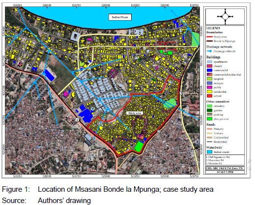
Initially, before housing construction flourished in Msasani Bonde la Mpunga, the settlement was considered one of the drainage basins to the Indian Ocean (Salukele, Toamukum & Mayunga, 2017: 38). It collected water volumes from Mwananyamala, Tandale and Mikocheni area and channelled water from higher parts of Dar es Salaam city via Kijitonyama river and University of Dar es Salaam through Sinza settlement. The then Dar es Salaam master plan of 1979 declared the settlement a wetland area and outlet to the ocean (Juma & John, 2018: 47).
From the 1980s, the development of residential and commercial buildings in Msasani Bonde la Mpunga gradually started and changed the settlement from a wetland (Kiunsi et al., 2009: 10). Currently, the settlement is densely built with informal (unplanned) and planned residential buildings. This study was conducted in a central part of the settlement (inscribed in red), with informal characteristics occupying roughly 0.28km2 of land with residential buildings (Figure 1). Such an area was considered to be information rich. Yin (2009) expounds that extensive exploration of real-life context is effectively carried out in information-rich areas similar to this study.
Combinations of criteria were used to select this case study area. These include the informal settlements in a flood-prone area, the settlements experiencing regular flooding, settlements densely built despite flood risk, and a settlement officially declared a flood-prone area. Based on the aforementioned criteria and a report by Pan-African START Secretariat, International START Secretariat, Tanzania Meteorological Agency & Ardhi University (2011: 17), Msasani Bonde la Mpunga was ranked first among other flood-prone settlements in Dar es Salaam such as Jangwani, Msimbazi Valley, Mikocheni B, Vingunguti, Magomeni Suna, Kigogo, Keko Machungwa, Mtambani, Mnyamani, and Kizinga.
4. METHODOLOGY
4.1 Research design
The study employed a case study design, using both quantitative and qualitative data. Following Creswell (2014: 4), the data were collected parallel, analysed separately, and subsequently merged during reporting. In this study, quantitative data was obtained, using a questionnaire survey to examine the processes different households went through to settle in flood-prone areas. Because households vary in socio-economic and other aspects, the study did not want to generalise the processes of settling in the areas; instead, a sample that was deemed representative enough was sought. Qualitative methods were employed for interviews and focus-group discussions (Yin, 2018: 33). The interviews and discussions explored how the participants in the study settled in a prone-flood settlement. The reason for collecting both quantitative and qualitative data is to elaborate on specific findings from the themes during the interviews and discussions, such as similar processes of acquiring land suggested by household respondents (Creswell, 2014: 4).
4.2 Sample size and sampling procedure
Using systematic sampling, 188 heads of households were sampled from 1,825 households in Msasani Bonde la Mpunga settlement. Systematic random sampling involves randomness at the starting point, and requires selecting every nth element until a number required is attained (Kothari, 2004: 15). In this study, the centre of the settlement was used as the starting point where at least one household in every five-households unit was considered during the survey. In addition, the household heads such as tenants, land inheritors, and those who participated in the processes of acquiring land in Msasani Bonde la Mpunga, a flood-prone area, were considered. Krejcie and Morgan (1970: 608) recommend a sample size of 217 for a population of 1,800. Although this recommendation does not validate the sample size of 188, the sampled residents (adults) were selected considering a 7% marginal error (Fox, Hunn & Mathers, 2009: 18).
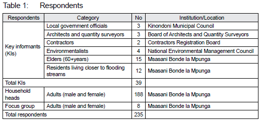
Since the researchers could not obtain a valid list of officials and other people involved in building land in flood-prone informal settlements, snowball sampling (Kothari, 2004: 17) was used to purposively draw 39 key informants, including local government officials (LGOs) from the Local Government Authority (LGA) in Kinondoni Municipality, architects and quantity surveyors (AQSs) from the Architects and Quantity Surveyors' Registration Board (AQRB), contractors from the Contractors Registration Board, environmentalists from the National Environmental Council (NEMC), as well as elders from Msasani Bonde la Mpunga. The ward leaders recommended the informants, except for the LGOs, whom the researchers visited in their respective offices. One focus-group discussion (FGD), comprising 8 adult participants (males and females), was conducted within the flood-prone Msasani Bonde la Mpunga. With the help of the ward leaders, the FGD participants were purposively sampled to involve willing and experienced people who had stayed in the case study area for 15 years or more.
The idea was to gain an in-depth understanding of land-acquisition processes from different viewpoints, experiences, beliefs, perceptions, and attitudes from multiple participants, as advised by Nyumba et al. (2018: 29). The details of the respondents are presented in Table 1.
4.3 Data collection
The Open Data Kit (ODK) programme administered a questionnaire survey to 188 selected household heads at the Msasani Bonde la Mpunga settlement between February and August 2021. ODK allows the collection of data offline and submits the data when internet connectivity is available (Mulligan et al. 2019). The first part obtained household head demographics such as gender, age, employment status, education level, building skills, and tenure status. In the second part on the processes that land seekers employ to acquire building land in Msasani Bonde la Mpunga settlement used in the survey, topics were extracted from reviews of the literature. In the 12-question survey, respondents were asked to indicate their choice of items that influence their acquisition practices, processes, ownership, and enforcements to obtain land (site) for building houses by means of the check-box method.
Qualitative data from key informants, notably government officials, selected household representatives (elders and residents closer to streams), and focus-group discussion members were collected through unstructured and semi-structured interviews (Creswell, 2017: 166). Through face-to-face interviews, the professional KIs answered 16 questions on how urban land seekers acquire land in flood-prone areas and construction techniques that can adapt to floods. Government officials answered 16 questions on how urban land seekers get into flood-prone areas, despite the prohibition of land-use policy and regulations. The elders, the residents closer to streams, and FGD members answered four questions each (on processes, approaches, and actors involved in acquiring their land) through face-to-face interviews and discussion. Interview questions were read to respondents in the Swahili language one after another by the researcher, and recorded responses were transcribed into English for analysis. Ninety minutes were spent conducting the discussion, as advised by Bhattacherjee (2012: 40), who proposes between 1.5 to 2 hours as adequate time for the FGD.
4.4 Data analysis
Quantitative data analysis on the respondent demographics, origins of residents who migrated towards flood-risk area, actors involved, size of plots, and prices of land acquired during the processes of acquiring land were analysed. This resulted in simple descriptive statistics such as frequencies, totals, and percentages after the data were transferred from ODK software to Statistical Package for the Social Sciences (SPSS) version 20 and Spreadsheets (Excel) 2019 programs.
For qualitative data analysis, recorded, translated, and transcribed interviews on the origin of residents, land acquisition practices, processes, and ownership of land in flood-risk areas were coded, arranged according to themes, and interpreted. For thematic analysis, interviews in terms of sentences and paragraphs were coded. Concepts were formed from the interviews by associating related codes. These concepts were then categorised into four themes (origin, practices, processes, ownership) and analysed with the aid of qualitative data analysis (MAXQDA) and Microsoft Word (MS) programs.
4.5 Limitations of the study
The findings of this study may only be generalised to other settlements in Dar es Salaam and elsewhere with a similar context.
5. RESULTS AND DISCUSSION
5.1 Household demographics
Results in Table 2 show that nearly three-quarters of the respondents in Msasani Bonde la Mpunga were male (household heads, 61%; key informants, 77%) and aged 41 years or more (household heads, 79.1%; key informants, 58.9%). The profile shows that the vast majority (household heads, 95.7%; key informants, 69.2%) worked for themselves, and that 89.9% of household heads and 53.8% of key informants engaged in activities such as petty trading, fishing, and domestic work in the up-market housing areas of adjacent settlements. Nearly half of the respondents had primary school education (household heads, 45.2%; key informants, 48.7%), and 50% of household heads had secondary school education. Of the key informants, 30.8% had a university education and were either architects (10.2%), engineers (12.8%), town planners (2.6%), graduates (2.6%), or technicians (2.6%), and 53.8% of these key informants (professionals) had over 20 years' work experience. Over half of the respondents (household heads, 72.5%; key informants, 53.8%) own their homes, and 73.9% had lived in the settlement for over 20 years, despite the area being a flood-risk area.
This implies that the respondents have adequate experience of the settlement to provide information that could help make useful deductions on the land-acquisition processes in flood-prone informal settlements in the study area.
5.2 Residents in flood-risk informal settlements
Results in Table 3 show that the majority of building land seekers (59%) who acquired land for residence in the flood-prone area of Msasani Bonde la Mpunga originated from within Dar es Salaam City. On the other hand, nearly an equal number of the other households originated either from within the same flood-prone Msasani Bonde la Mpunga informal settlement (21%), or from outside the city (20%).
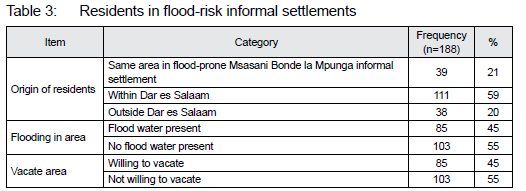
Residents who originated within Dar es Salaam City rather than the flood-risk area (Msasani Bonde la Mpunga) and those from outside the city portray the effects of migration trends, particularly from rural to urban areas. As new settlers in urban areas (cities), they seek cheap land and housing accommodation, notably in the informal settlements, including those susceptible to flooding. Ramiaramanana & Teller (2021: 1) support this, adding that migration trends, population growth, and complex urbanisation increases the demand for building (housing) land and force people to acquire land and build in flood-prone areas. Amoako (2016: 10) refers to these people as the "urban newcomers", arguing that they are compelled to live in hazardous (flood-risk) areas for cheap accommodation on the blind sides of the formal planning systems.
It is worth noting that residents who originated from the same flood-risk settlement were born in the same flood-risk locality. These residents were never engaged in the land-acquisition processes. Although 45% of the residents indicated regular flooding in the settlement, the majority of them (55%), as shown in Table 3, claimed that it is difficult for them to vacate the area, whereas 45% of them accepted to vacate if their livelihood in new destinations is assured. The reason that some of them are not ready to vacate is that they have lived and established their social networks in the area over generations. Askman, Nilsson and Becker (2018: 148) report similar findings in Akuressa, Sri Lanka, noting the perceived difficulty for the residents to relocate elsewhere, due to strong connections (social ties) established with the place over generations. When asked where she was living before acquiring building land at Msasani Bonde la Mpunga, a 64-year-old female household head at Msasani Bonde la Mpunga, who migrated from outside Dar es Salaam City explained:
"I came to Dar es Salaam in 1984. In the process of looking for a place to live, I rented a single room in a mud house owned by an old man here in the settlement and settled. In 1988, I managed to secure a piece of building land and constructed my own house; the place I live to date."
When asked about the situation of water and the level of flooding in the settlement when she acquired her building land, she remarked:
"I repeat, there were no serious floods by that time, but small tributaries of water channels were passing on [their] own ways to the ocean because houses were distantly scattered. Initially, many people used this area as farming fields. Floods were experienced when prospective investors started buying land here for building. In the course of building land, they blocked the natural water ways."
Table 3 shows that 55% of the residents indicated that their plots were not flooding and thus not affected by floodwater. The reason for this is that, initially when they acquired building land, their plots were either located far from the natural water streams or slightly elevated from the main natural streams.
This implies that not all residents in flood-prone settlements are equally affected or that all floods are disastrous. Becker (2014: 61) supports this, arguing that not all floodwater is harmful, because, in many other contexts, floods support biodiversity, wetlands, and agriculture, making its management a complex phenomenon. For example, a 63-yer-old male respondent who migrated from within Dar es Salaam City and settled in Msasani Bonde la Mpunga was quoted as saying:
"I grew up in Ilala Municipality, Dar es Salaam since 1968s. I have known Msasani Bonde la Mpunga since 1972 because my uncle lived here before and he was engaged in fishing activities. I used to visit my uncle several times, especially during the school holidays. Being close to my uncle, he assisted me in securing a building land here. By that time, the flood was not a big threat."
During the FGD, some participants stated that they were born in the Msasani Bonde la Mpunga settlement. As a result, they have no plans to leave the settlement, for they hope the government will provide solutions to flooding. John et al. (2019) revealed consistent findings in Tanzania where, following the flood incidences of 2011, flood-affected victims were relocated to Mabwepande settlement, on the outskirts of Dar es Salaam City. However, some returned to the original settlement because of inadequate facilities provided by the government to meet their livelihoods (John et al., 2019: 402). This implies that the government sometimes aggravates the unofficial process of acquiring flood-risk land because, during critical flooding, it intervenes and relocates flood victims without adequate support. One of the FGD members, a 54-year-old male respondent born in the settlement had this to say with regard to living in the flood-risk area:
"I know Msasani Bonde la Mpunga since 1960, because I was born and grew up here. We lived in a place called Msasani Kambini, which was a camp for sisal plantation workers, especially the Makonde who migrated from Southern Tanzania to work on sisal plantations here. So, I did not migrate to this place. That time, flooding occurred in some parts of the settlement, but it was not severe."
The foregoing narrations from one of the respondents substantiate that, initially, the Msasani Bonde la Mpunga settlement experienced moderate floods before it was not densified with houses upstream. This situation prompted most of the residents to move and acquire building land despite flood risks, for they believed that they could cope. By implication, before densification of houses, proper management and governance of flood risk at the settlement could have helped reduce flood risks.
5.3 Land-acquisition practices
According to residents in Msasani Bonde la Mpunga settlement, the acquisition of land was done through informal land-parcelling practices (Table 5). This is similar to other informal settlements with non-flood risks (e.g., in Kihonda, Morogoro-Tanzania), as revealed by Kombe & Kreibich (2001: 10); the difference is the price of land between these settlements. For example, residents claimed that, initially, the price of land in the settlement was low and affordable compared to other informal settlements outside floodplains. Kousky and Shabman (2020: 513) observed consistent results in the United States, noting that land and home prices declined after floods and rebounded a few years later. This implies that residents may take risks to initiate the process of moving and settling in flood-risk areas when prices of land are convincingly low.
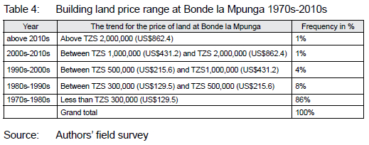
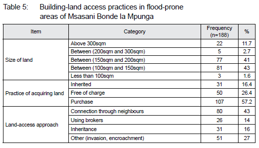
As shown in Table 4, the majority (86%) of parcelled land (1970s-1980s) was purchased at less than TZS 300,0002 (US$129.5). The reason for this is that the area was regarded as a farming and flood-prone area. Land prices and demand kept increasing as the years passed (Table 4). When asked about price equivalence to the planned plots by then (1970s-1980s), respondents mentioned that the price was almost thrice that of Msasani Bonde la Mpunga. This accelerated the process of acquiring building land despite flood risk, especially by the urban new settlers. Nchito (2007: 541) concurs with this observation, stating that, in Zambia, people (especially low-income earners) move and build houses on any land they can find, even if it is a flood-risk area. What is important to them is simply meeting their housing requirements.
Table 4 reveals that land prices increased, although the settlement was a flood-risk area. The respondents noted that this was attributed to the availability of prospective land seekers who constructed apartments for renting. Jahangir (2018: 12) reported similar findings, citing that, in Dhaka-Bangladesh, the high demand for apartments led to land acquisition for building houses in flood-prone areas. Moreover, the respondents attested that, prior to prospective investors coming to the Msasani Bonde la Mpunga settlement in the 1990s, the acquisition of building land was almost free of charge. The land-acquisition process was facilitated through friends and relatives, as well as social relations because such land was mainly valued for farming.
When asked about the process he went through when he acquired land, a 63-year-old male key informant explained:
"In the 1970s, there were indigenous landowners occupying the land. They sold pieces of land almost free of charge because land value here was low. The area was mainly for farming, with few houses and people. Sometimes acquisition of land here was through good relationships, especially marriage and inheritance of land from ancestors. I bought this land in 1973, and by then, floods passed through the course towards the ocean. The coming of prospective investors and increase of houses in the 1990s made flooding severe."
The foregoing testimony suggests that the value of the land in Msasani Bonde la Mpunga settlements was low, and its transfer depended on the relationship that existed between actors involved in the transaction. Land acquisition was practised for appreciations with token payments, for it was considered farming land. This was attributed to the fact that demand for land, population growth, and housing cluster in the settlement were still low and scattered. This triggered the building land seekers to settle in this flood-risk area.
Regarding the practice of acquiring building land, results show that more than half (57.2%) of the residents (Table 5) acquired parcelled land (plots) through purchase from indigenous landowners. Roughly 26.4% acquired land free of charge under the umbrella of friendship and relationship. Nearly 16.4% of the residents never experienced the land-acquisition process because they were born in the settlement and automatically inherited land from their parents or relatives. From Table 5, it is worth noting that the practice of acquiring land through parcelled pieces of land in flood-prone informal settlements dominates other practices such as free access and inheritance. It resembles land-access practices and processes conducted in other informal settlements located outside flood-hazard areas. This suggests why land governance in hazardous areas has yet to be prioritised and protected.
As shown in Table 5, a reasonably big (43%) size of the plots that were subdivided for residence ranged between 100sqm (10mx10m) and 200sqm (10mx20m). Most of these do not conform to the current minimum standards (high density) and minimum classification of plots in planned settlements in Tanzania which ranges between 301m2 and 600m2 (URT, 2018: 3). However, observations made in various old, planned settlements (planned between 1970s and 1980s) in Tanzania such as Sinza, Kijitonyama, Magomeni, Kariakoo, and Mikocheni showed a range between 288m2 and 360m2. These plot sizes closely relate to those subdivided in the flood-prone area of Msasani Bonde la Mpunga. Perhaps this suggests that plot subdivision practices in the flood-risk area of Msasani Bonde la Mpunga were imitated in planned settlements. Much as these plots are small (Table 5), and the construction of houses is likely to cover nearly 100% of the site (plot), as residents try to meet house design requirements. This means that there are no setbacks around the house; even going around the house is difficult. Such situations eventually accelerate flooding, as houses block most of the floodwater drainage systems.
5.4 Land-acquisition processes
Field results revealed various approaches that building land seekers use to acquire land at Msasani Bonde la Mpunga settlement (Figure 2). These include connections from friends, neighbours, and relatives; use of brokers and other approaches such as encroachments and invasions. As shown in Table 5, over 40% of the residents acquired land through connections from friends, neighbours, and relatives. These assist new urban land seekers with measures they use to cope with flood risks. This is congruent with Botzen et al. (2019: 2144), who argue that new residents in flood-prone areas adopt measures of coping with floods through neighbours' information. Other (14%) residents acquired building land through brokers who connect land transaction deals for payments. The use of brokers in flood-risk land acquisition is similarly applied in non-flooding informal settlements (Nuhu & Mpambije, 2017: 289).
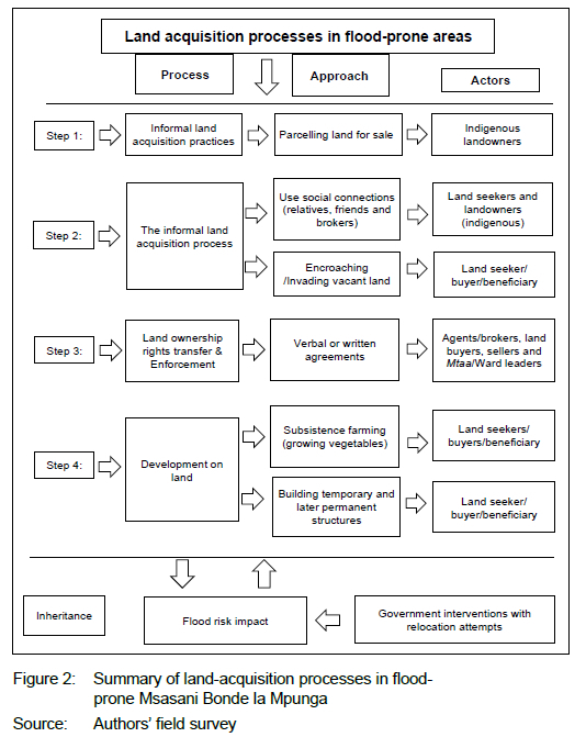
Results further show that roughly 27% of the residents acquired land by other means such as land invasions and encroachment (Table 5). When asked how this was possible despite it being against land-use regulatory frameworks, government officials explain that the government has mercy with urban land seekers because it has a low capacity to plan and provide (allocate) planned residential plots to every individual in need of housing land. Further, it was revealed that, since people themselves (self-help initiatives) construct houses without any government subsidies, it becomes difficult to stop people from acquiring land even in flood-prone areas. For them, it is an effort to realise their shelters. Nchito (2007), in Zambia, support the argument, noting that it is hard for people, especially those with low income, to stop acquiring land and erect house structures for shelter in areas that they view as vacant and unmanageable land. Therefore, the government keeps advising people to avoid flood-prone areas because its development contravenes land-use regulations. As such, the government does not force people to vacate flood-prone areas, unless they are affected by severe flooding.
Urban settlers who acquired land in flood-prone areas by other means such as invasion and encroachment (Table 5) were asked about their processes. Most of them mentioned that acquiring land may start by performing different temporal activities such as subsistence farming (e.g., growing vegetables for sale). Urban land governors view these activities as temporal works. With time, they own land and finally establish permanent residences.
Pottier et al. (2005: 4) provide similar observations in England and Wales, noting that any country can minimise flood damages to invade floodplains, by controlling urban uses commonly called encroachments. Discussing a similar case from South Africa, Dube, Nhamo and Chikodzi (2021: 10) state that, in the City of Cape Town, residents' cost of displacement has increased because of the invasion of disaster areas, including flood-prone areas, urban sprawl, and extreme weather conditions. This implies that the invasion of land contributes significantly to the process of acquiring building land in flood-prone areas.
It is apparent from Figure 2 that the processes of acquiring land in flood-prone areas of Msasani Bonde la Mpunga were informally conducted, mainly through land-parcelling practices. Social networks, connections, brokers, and ward leaders are used to authenticate sellers' rights as well as transfer and protect rights. The processes are similar to those taking place in any other informal settlements outside flood-prone areas. Inheritance of land was also revealed as one of the ways of accessing land in flood-prone Msasani Bonde la Mpunga. In these processes, the government institutions responsible for land management are not involved. However, they intervene when there are severe floods (i.e., rescue or resettle people) or when there are disputes.
Furthermore, roughly 16% of the households (Table 5) reported that they inherited land from their ancestors, and that, therefore, they did not undergo any processes of acquiring building land in the settlement. This is also revealed in Figure 2, where inheritance of land is detached from other processes used by households to acquire building land in flood-prone Msasani Bonde la Mpunga. Regardless of the flood risks, households attested that they had established strong connections with family members, relatives, and friends. Askman et al. (2018: 153) reported similar results in Akuressa, Sri Lanka, stating that residents were adamant about shifting the flood-risk area at Akuressa because of the social ties they had established with relatives and friends in the area. This implies that channelling to flood-risk areas may also be fuelled by the friends and relatives available, despite flood-risk incidences.
5.5 Landownership rights, transfer, and enforcement
Regarding landownership at Msasani Bonde la Mpunga, residents were asked how they owned land, despite being restricted by land-use regulations. The FGD participants explained that, between the 1970s and the 1980s, such land was used for farming, so land rights were transferred by way of verbal agreements because the land value was still low. Zhang (2016: 12) concurs with the low value of land in flood-prone areas, arguing that, in the Fargo-Moorhead area in the United States, the market value of land and houses in floodplains dropped because of flooding, compared to other areas outside the floodplains. A 61-year-old female and a participant in the FGD explained the land ownership phenomenon in the flood-prone areas:
"In the past, you could not say that indigenous landowners were really selling building land for profit. You just had to talk to the landowner to give you a piece of land for cultivation. Landowner apportioned a piece of land agreed by both sides and put signs and symbols using sticks for boundary demarcations."
Residents further explained that the construction of houses in the settlement flourished over time, and that the settlement's ability to withhold flooding kept on getting worse. Despite flood-risk incidences, the prospective building land seekers started buying land in the settlement for the construction of residential apartments. This contributed to increased land value in the settlement and attracted written agreements despite flood risks. Junger et al. (2022: 11) support the argument that, in the Alpine region in Austria, there is an increase in the development in settlements in flood-prone areas, due to the high demand for housing. Jahangir (2018: 12) observed a similar situation in Dhaka, Bangladesh, as he associates the land value increase in flood-prone areas with the high demand for apartment buildings. This implies that the process of acquiring land in flood-risk areas may be obscured in land-use legislation prohibiting the development of buildings in flood-prone areas on the blind side of residents' meeting housing accommodations.
Land at Msasani Bonde la Mpunga started gaining value despite the risk of floods, because of its proximity to many urban centres in the city. This attracted enforcement of land-rights transfer via grassroots institutions (lowest organs of local governance in Tanzania) through ward (local) leaders under Ward Executive Officer (WEO). The ward/sub-ward leaders (street leaders) under the WEO became the enforcers of land rights (Figure 2). Kombe and Kreibich (2001: 10) made a similar observation when studying informal land management and the misconception about its illegitimacy.
Government officials were required to explain how WEO and sub-ward leaders participate in issuing land rights (enforcement) and how do land seekers acquire such land while such areas are prohibited by land-use legislation. Their responses revealed that acquiring land in such areas is against land-use legislation that governs flood-prone areas. They insisted that nobody is allowed to move and acquire land in flood-prone areas, and that all constructions in such areas are illegal by law. Quoting some land-use legislations that officials declared, the Land Act No. 4 of 1999, section 7 (a-f) declares hazardous land (land that can impose danger to life) or land that may lead to degradation or environmental destruction as unsuitable for human development (URT, 1999: 52-53).
Tanzania's Environmental Management Act (EMA) of 2004 restricts development on swamps as environmentally sensitive areas (URT, 2004: 13). Similarly, section 4.3.9 of the National Human Settlements Development Policy of 2000 stresses the invasions of fragile land as a critical challenge for urban development (URT, 2000). This perhaps postulates that the process exercised by the building land seekers to acquire land in flood-risk areas lacks strong governance and institutional machinery to prohibit it.
An Architectural Technician from KMC who is mandated to undertake building permit assessment, issuing, and enforcing building construction regulations was interviewed on the processes that involve residents to acquire land in flood-prone areas. He remarked:
"These people trick us and sometimes build in weekends. They collaborate with the Sub-ward leaders and provide them with some tokens not to report them at the LGA offices. They temporarily start as vegetable growers; with our low capacity to regularly patrol crosscheck, such areas automatically develop into settlements. Unfortunately, removing them becomes difficult, because of government's sympathies."
Surprisingly, the residents mentioned that the signing process for land ownership in the settlement had never been restricted, and it is usually done before the WEOs' office, involving land sellers, buyers, and witnesses. These oversee the exercise, like in many other settlements outside floodplains. This event is preceded by a prior visit to the area by the team of WEO and all other actors involved in the land-transactions process to crosscheck the boundaries. Ono and Kidokoro (2021: 3) observed similar findings in Nairobi, Kenya, where village elders sometimes stand as witnesses, and are expected as mediators between the two parties in case any land-related conflict arises. Permanent features, signs, and symbols of various objects such as trees and remarkable figures, were used to set and mark plot boundaries for conflict resolutions. This stage allows the beginning of the construction process in the settlement. From the process, it implies that the government's involvement in managing risk areas as per land-use legislation is poorly and complex; however, the government is involved when a flood is severe, causing great harm to residents (Figure 2). It acts retrospectively, particularly when there are critical flooding cases in flood-risk settlements, by attempting to relocate people, which is always complex and volatile to flood victims.
6. CONCLUSIONS AND POLICY RECOMMENDATIONS
6.1 Conclusions
Although the trend of migration (rural to urban or within urban areas) is a global phenomenon, cities need to prepare for it because it is seemingly complex and has far-reaching effects. One of them is how it compels the process of urban land seekers to acquire land and settle in flood-prone areas. This process of acquiring land in flood-prone areas is driven by rapid urbanisation trends, unregulated urban expansion, and failure to deliver affordable building land, especially for the poor. These attributes fuel cities into the inevitable growth of informal settlements and flood risks, particularly in the countries of the Global South and Tanzania is no exception. The growing urban population, especially the low-income people, are compelled to seek cheap and affordable housing land as they prepare for a new life in cities. As new migrants, they often lack the capacity to stabilise and establish decent settlements in non-flood areas.
Inscribed by poor infrastructure conditions, these newcomers aggravate the severity of floods because they build houses haphazardly without following designs and construction guidelines. Although land governance, especially land-use regulatory frameworks (policies, laws, regulations, and guidelines), prohibit the development in flood-prone areas, it still continues. Prohibition fails because of poor urban planning and inadequate governance of such areas. Often, actions to protect flood-prone areas are taken at a mature stage of an informal settlement when such areas are saturated with houses. The situation is worsened by the fact that grassroots institutions, notably the SWLs and WEOs, are involved in land sales in flood-prone areas. They officiate informal land sales, transfer, and protection of rights.
By implications, the LGAs (the higher organs at the municipal level that plan and allocate land) seem to simply look on these informal land-acquisition processes in flood-prone areas. LGAs' capacity to provide buildable planned plots for newcomers in cities is almost non-existent. They have almost turned a blind eye, leaving residents to pursue self-help initiatives in solving building land and housing problems. This article revealed that the processes used by urban land seekers to acquire building land in flood-prone areas of Msasani Bonde la Mpunga encompass informal acquisition of land through tapping social connections with relatives, neighbours, friends, and brokers. The grassroots institutions enforce landownership rights and enforcements at Mtaa level3 and ward levels. These also sanction verbal and written sale agreements before the development of the land. This is what the findings revealed at Msasani Bonde la Mpunga settlement. These findings contribute to the literature, policy recommendations, and actions for governing flood-prone informal settlements.
6.2 Policy recommendations
The article calls for strengthening the enforcement mechanisms for the existing land-use regulatory frameworks established to prohibit settlement in flood-prone areas. Bare prohibitions and restrictions have yet to work. Resilient policy measures such as urban agriculture (Douglas, 2018: 3), and the application of public green parks, especially in virgin flood-prone areas, should be mainstreamed into the planning and development of land uses. Such policy measures should be co-developed with local communities, LGAs and other stakeholders. These should be applied at the infant stages when the settlement is still sparsely built to check encroachments and invasions in fragile environmental areas. Applying the aforementioned measures automatically preserves such areas as public domains prohibited from illegal acquisitions.
Therefore, it is imperative to enhance responsible policy drivers by strengthening and re-integrating land-use policy instruments in flood-prone and other environmentally hazardous areas. In addition, emphasis on appropriate planning approaches, monitored land-acquisition practices, and processes on land governance aspects are necessary.
Policymakers and practitioners should prioritise rethinking the socio-economic priorities of urban land seekers in terms of sustainable land-use planning, disaster risk reduction, and climate-adaptation interfaces. This should go parallel with alternative strategies of inclusive land for housing urban land seekers, especially the low-income group who have resorted to settling in flood-prone informal settlements.
Capacity-building, particularly on flood-adaptation responses to facilitate living with floods, should be developed to support those community members who have already acquired building land and settled in flood-prone settlements. They should be trained on resilient construction and adaptation of buildings to flooding, including consideration of spaces for drainage channels at the plot level. Government via LGAs, professional boards such as AQRB, CRB and NEMC should play active roles in disseminating information on dos and don'ts in flood-prone areas. Education for indigenous landowners on appropriate sizes of plots should be provided and monitored by the grassroots institutions at Mtaa level. The intention is to provide adequate setbacks at the plot level during house construction to help manage floodwater drainage channels and ultimately reduce the impacts of flooding.
In addition, resilient construction and adaptation of buildings via indigenous knowledge are critical areas that need further research to understand the potential of untapped skills and knowledge that could improve the persisting challenges of building in flood-prone areas. Importantly, given the prevailing poor governance attributed to the overemphasis on top-down approaches, in the future, interventions should focus on a bottom-up approach illuminated by greater involvement of community members in the co-production of interventions necessary to improve land governance in informal settlements. This is instrumental in enhancing policy interventions and implementation strategies.
ACKNOWLEDGEMENTS
We thank our colleagues at the Institute of Human Settlement Studies (IHSS), for their positive comments on the article. This article was written as part of fulfilling PhD requirements at Ardhi University and the PhD programme under the project "Governance and Planning for Resilience Cities in Sub-Saharan Africa (GOPLAREA) under In-country/In-region Scholarship Programme - Tanzania, 2019 and has been funded by DAAD.
REFERENCES
ADELEKAN, I., JOHNSON, C., MANDA, M., MATYAS, D. & BLESSING, M.U. 2015. Disaster risk and its reduction: An agenda for urban Africa. International Development Planning Review, 37(1), pp. 33-43. DOI: 10.3828/idpr.2015.4 [ Links ]
AGYABENG, A.N., PEPRAH, A.A., MENSAH, J.K. & MENSAH, E.A. 2022. Informal settlements and urban development discourse in the Global South: Evidence from Ghana. Norsk Geografisk Tidsskrift-Norwegian Journal of Geography, 76(4), pp. 242-253. DOI: 10.1080/00291951.2022.2113428 [ Links ]
AHIABLAME, L. & SHAKYA, R. 2016. Modeling flood reduction effects of low impact development at a watershed scale. Journal of Environmental Management, 171, pp. 81-91. DOI:10.1016/j.jenvman.2016.01.036 [ Links ]
AMOAKO, C. 2016. Brutal presence or convenient absence: The role of the state in the politics of flooding in informal Accra, Ghana. Geoforum, 77, pp. 5-16. DOI: 10.1016/j.geoforum.2016.10.003 [ Links ]
ANANDE, D.M. & LUHUNGA, P.M. 2019. Assessment of socio-economic impacts of the December 2011 flood event in Dar es Salaam, Tanzania. Atmospheric and Climate Sciences, 9(3), pp. 421-437. DOI: 10.4236/acs.2019.93029 [ Links ]
ARIF, M.M., AHSAN, M., DEVISCH, O. AND SCHOONJANS, Y., 2022. Integrated Approach to Explore Multidimensional Urban Morphology of Informal Settlements: The Case Studies of Lahore, Pakistan. Sustainability, 74(13), p.7788. DOI: 10.3390/su14137788 [ Links ]
ASKMAN, J., NILSSON, O. & BECKER, P. 2018. Why people live in flood-prone areas in Akuressa, Sri Lanka. International Journal of Disaster Risk Science, 9(2), pp. 143-156. DOI: 10.1007/s13753-018-0167-8 [ Links ]
BECKER, P. 2014. Sustainable science: Managing risk and resilience for sustainable development. Amsterdam: Elsevier. https://doi.org/10.1016/B978-0-444-62709-4.00005-1 [ Links ]
BHATTACHERJEE, A. 2012. Social science research: Principles, methods, and practices. 2nd edition. Tampa, FL: University of South Florida, Scholar Commons. [ Links ]
BOTZEN, W.J.W., KUNREUTHER, H., CZAJKEWSKI, J. & MOEL, D.H. 2019. Adoption of individual flood damage mitigation measures in New York City: An extension of protection motivation theory. Risk Analysis, 39(10), pp. 2143-2159. DOI: 10.1111/risa.13318 [ Links ]
COLLIER, P. & VENABLES, A.J. 2014. Housing and urbanisation in Africa: Unleashing a formal market process. Policy Research Working Paper No. 6871. Washington, DC: World Bank. https://doi.org/10.1596/1813-9450-6871 [ Links ]
COLLIER, P., GLAESER, E., VENABLES, A., BLAKE, M. & MANWARING, P. 2019. "Policy options for informal settlements" Version 1. IGC Cities that Work Policy Framing Paper. [ Links ]
CRED (Centre for Research on the Epidemiology of Disasters). 2015. The human cost of weather-related disasters: 1995-2015. United Nations Office for Disaster Risk Reduction, Emergency Events Database. Brussels: UNISDR. [ Links ]
CRED (Centre for Research on the Epidemiology of Disasters). 2019. Natural disasters 2019: Now is the time to not give up. Brussels: UNISDR. [ Links ]
CRESWELL, J.W. 2014. Research design: Qualitative, quantitative, and mixed method approaches. London: Sage Publications. [ Links ]
CRESWELL, J.W. 2017. Research design: Qualitative, quantitative, and mixed methods approaches. 3rd edition. London: Sage Publications. [ Links ]
DE RISI, R., JALAYER, F., DE PAOLA, F., IERVOLINO, I., GIUGNI, M., TOPA, M.E., et al. 2013. Flood risk assessment for informal settlements. Natural hazards, 69(1), pp. 1003-1032. https://doi.org/10.1007/s11069-013-0749-0. [ Links ]
DODMAN, D. LECK, H., RUSCA, M. & COLENBRANDER, S. 2017. African urbanisation and urbanism: Implications for risk accumulation and reduction. International Journal of Disaster Risk Reduction, 26, pp. 7-15. DOI: 10.1016/j.ijdrr.2017.06.029 [ Links ]
DOUGLAS, I. 2018. The challenge of urban poverty for the use of green infrastructure on floodplains and wetlands to reduce flood impacts in intertropical Africa. Landscape and Urban Planning, 180, pp. 262-272. DOI: 10.1016/j.landurbplan.2016.09.025 [ Links ]
DUBE, K., NHAMO, G. & CHIKODZI, D. 2021. Flooding trends and their impacts on coastal communities of Western Cape province, South Africa. GeoJournal, 87(Suppl. 4), pp. 453-468. DOI: 10.1007/s10708-021-10460-z. [ Links ]
ECHENDU, A.J., 2020. The impact of flooding on Nigeria's sustainable development goals (SDGs). Ecosystem Health and Sustainability, 6(1), p.1791735. DOI: 10.1080/20964129.2020.1791735. [ Links ]
FOX, N., HUNN, A. & MATHERS, N. 2009. Sampling and sample size calculation. Nottingham: The National Institutes for Health Research. Research Design Service for the East Midlands/UK: Sheffield: Yorkshire & the Humber. [ Links ]
GANGULY, M., AYNYAS, R., NANDAN, A. & MONDAL, P. 2018. Hazardous area map: An approach of sustainable urban planning and industrial development - A review. Natural Hazards, 91(3), pp. 1385-1405. DOI: 10.1007/s11069-018-3179-1. [ Links ]
GENCER, E.A. 2013. The interplay between urban development, vulnerability, and risk management. New York: Springer. https://doi.org/10.1007/978-3-642-29470-9 [ Links ]
HANDAYANI, W., CHIGBU, U.E., RUDIARTO, I. AND PUTRI, I.H.S., 2020. Urbanization and Increasing Flood Risk in the Northern Coast of Central Java-Indonesia: An Assessment towards Better Land Use Policy and Flood Management. Land, 9(10), p.343. https://doi.org/10.3390/land9100343 [ Links ]
IFRC (International Federation of Red Cross and Red Crescent Societies). 2019. Africa: Floods. Situation Report. Information bulletin. [Online]. Available at: <https://reliefweb.int/report/cameroon/africa-floods-information-bulletin> [Accessed: 21 July 2022]. [ Links ]
JAHANGIR, A. 2018. Rapid urbanisation and changing land values in mega cities: Implications for housing development projects in Dhaka, Bangladesh. Bandung: Journal of the Global South, 5(1), pp. 1-19. DOI: 10.1186/s40728-018-0046-0 [ Links ]
JHA, A.K., BLOCH, R. & LAMOND, J. 2012. Cities and flooding: A guide to integrated urban flood risk management for the 21st century. Washington, DC.: World Bank. https://doi.org/10.1596/978-0-8213-8866-2 [ Links ]
JOHN, R. 2020. Flooding in informal settlements: Potentials and limits for household adaptation in Dar es Salaam City, Tanzania. American Journal of Climate Change, 9(2), pp. 68-86. DOI: 10.4236/ajcc.2020.92006 [ Links ]
JOHN, R., MAGINA, F.B. & KEMWITA, E.F. 2019. From Msimbazi River Valley to Mabwepande Settlement: The resettlement process and its challenges. Current Urban Studies, 7(3), pp. 399-426. DOI: 10.4236/cus.2019.73020 [ Links ]
JUMA, N. & JOHN, R. 2018. Compliance with planning regulations in hazardous areas and its impacts: A case of Msasani Bonde la Mpunga in Dar es Salaam City, Tanzania. African Journal on Land Policy and Geospatial Sciences, 1(2) (Special issue), pp. 41-52. [ Links ]
JUNGER, L., HOHENSINNER, S., SCHROLL, K., WAGNER, K. AND SEHER, W., 2022. Land Use in Flood-Prone Areas and Its Significance for Flood Risk Management-A Case Study of Alpine Regions in Austria. Land, 11(3), p.392. DOI: 10.3390/ land11030392 [ Links ]
KASIM, O.F., WAHAB, B. & OWENIWE, M.F. 2021. Urban expansion and enhanced flood risk in Africa: The example of Lagos. Environmental Hazards, 21(2), pp.137-158. https://doi.org/10.1080/17477891.2021.1932404 [ Links ]
KIHATO, C.W., ROYSTON, L., RAIMUNDO, J.A. & RAIMUND, I.M. 2013. Multiple land regimes: Rethinking land governance in Maputo's peri-urban spaces. Urban Forum, 24(1), pp. 65-83. doi: 10.1007/s12132-012-9163-z. [ Links ]
KIRONDE, J.M.L. 2016. Governance deficits in dealing with the plight of dwellers of hazardous land: The case of the Msimbazi River Valley in Dar es Salaam, Tanzania. Current Urban Studies, 4(3), pp. 303-328. DOI: 10.4236/cus.2016.43021 [ Links ]
KIUNSI, R., KASSENGA, G., LUPALA, J., MALELE, B., UHINGA, G. & RUGAI, D. 2009. Mainstreaming disaster risk reduction in urban planning practices in Tanzania: AURAN Phase II Project Final Report. Dar es Salaam, Tanzania. [Online]. Available at: <https://www.preventionweb.net/flles/13524_tanzaniafinalreport27oct09Mainstrea.pdf.> [Accessed: 16 August 2022]. [ Links ]
KOMBE, W.J. & KREIBICH, V. 2001. Informal land management in Tanzania and the misconception about its illegality. Paper presented at the ESF/N-Aerus Annual Workshop on "Coping with Informality and Illegality in Human Settlements in Developing Countries", 23-26 May, Leuven and Brussels. [ Links ]
KOMBE, W.J. 2005. Land use dynamics in peri-urban areas and their implications on the urban growth and form: the case of Dar es Salaam, Tanzania. Habitat International, 29(1), pp.113-135. https://doi.org/10.1016/S0197-3975(03)00076-6. [ Links ]
KOTHARI, C.R. 2004. Research methodology: Methods and techniques. 2nd revised edition. New Delhi, India: New Age International Limited. [ Links ]
KOUSKY, C. & SHABMAN, L. 2020. Flood risk and the U.S. housing market. Journal of Housing Research, 29(S1), pp. S3-S24. DOI: 10.1080/10527001.2020.1836915. [ Links ]
KREJCIE, R.V. & MORGAN, D.W. 1970. Determining sample size for research activities. Educational and Psychological Measurement, 30, pp. 607-610. https://doi.org/10.1177/001316447003000308 [ Links ]
KUNDZEWICZ, Z.W., SU, B., WANG, Y., WANG, G., WANG, G., HUANG, J. & JIANG, T. 2019. Flood risk in a range of spatial perspectives - From global to local scales. Natural Hazards and Earth System Sciences, 19(7), pp. 1319-1328. DOI: 10.5194/nhess-19-1319-2019 [ Links ]
MAGINA, F.B., KYESSI, A. & KOMBE, W., 2020. The urban land nexus-challenges and opportunities of regularising informal settlements: The case studies of Dar es Salaam and Mwanza in Tanzania. Journal of African Real Estate Research, 5(1), pp. 32-54. https://doi.org/10.15641/jarer.v5i1.837.Abstract. [ Links ]
MASSEY, R. 2015. Integral theory: A tool for mapping and understanding conflicting governmentalities in the upgrading of Cape Town's informal settlements. Urban Forum, 26(3), pp. 303-319. DOI: 10.1007/s12132-015-9252-x [ Links ]
MBURA, J.A. 2014. Disaster management and persistent flooding disaster in Dar es Salaam. Unpublished PhD dissertation. The Open University of Tanzania. [ Links ]
MULLIGAN, J., BUKACHI, V., GREGORIOU, R., VENN, N., KER-REID, D. & TRAVERS, A., et al. 2019. Participatory flood modelling for negotiation and planning in urban informal settlements. Engineering Sustainability, 172(7), pp. 354-371. https://doi.org/10.1680/jensu.17.00020. [ Links ]
NASSAR, D.M. & ELSAYED, H.G. 2018. From informal settlements to sustainable communities. Alexandria Engineering Journal, 57(4), pp. 2367-2376. DOI: 10.1016/j.aej.2017.09.004 [ Links ]
NCHITO, W.S. 2007. Flood risk in unplanned settlements in Lusaka. Environment and Urbanisation, 19(2), pp. 539-551. DOI: 10.1177/0956247807082835 [ Links ]
NSORFON, I.F. 2015. Exploring social vulnerability to natural disasters in urban informal settlements-perspectives from flooding in the slums of Lagos, Nigeria. Unpublished PhD dissertation, Universität zu Köln. [ Links ]
NUHU, S. & MPAMBIJE, C.J. 2017. Land access and corruption practices in the peri-urban areas of Tanzania: A review of democratic governance theory. Open Journal of Social Sciences, 5(4), pp. 282-299. DOI: 10.4236/jss.2017.54025. [ Links ]
NYUMBA, T.O., WILSON, K., DERRICK, C.J. & MUKHERJEE, N. 2018. The use of focus group discussion methodology: Insights from two decades of application in conservation. Methods in Ecology and Evolution, 9(1), pp. 20-32. DOI: 10.1111/2041-210X.12860. [ Links ]
ONO, H. & KIDOKORO, T. 2020. Understanding the development patterns of informal settlements in Nairobi. Japan Architectural Review, 3(3), pp. 384-393. https://doi.org/10.1002/2475-8876.12161 [ Links ]
ONO, H. & KIDOKORO, T. 2021. Process and mechanism of land acquisition and land tenure security in informal settlements in Nairobi. Japan Architectural Review, 4(1), pp. 168-175. DOI: 10.1002/2475-8876.12204. [ Links ]
PAN-AFRICAN START SECRETARIAT, INTERNATIONAL START SECRETARIAT, TANZANIA METEOROLOGICAL AGENCY & ARDHI UNIVERSITY 2011. Final report on Urban Poverty and Climate Change in Dar es Salaam, Tanzania: A case study. [Online]. Available at: <https://start.org/wp-content/uploads/dar-case-study_p1-65_compressed.pdf.> [Accessed: 12 June 2022]. [ Links ]
PARNELL, S. 2015. Fostering transformative climate adaptation and mitigation in the African city: Opportunities and constraints of urban planning. In: Pauleit, S. et al. (Eds). Urban vulnerability and climate change in Africa: A multidisciplinary approach. Part of the Future City book series, volume 4. Cham, Switzerland: Springer, pp. 349-367. https://doi.org/10.1007/978-3-319-03982-4_11 [ Links ]
POTTIER, N., PENNING-ROWSELL, E., TUNSTALL, S. & HUBERT, G. 2005. Land use and flood protection: Contrasting approaches and outcomes in France and in England and Wales. Applied Geography, 25(1), pp. 1-27. DOI: 10.1016/j.apgeog.2004.11.003 [ Links ]
RAJAPAKSA, D., WILSON, C., MANAGI, S., HOANG, V. & LEE, B. 2016. Flood risk information, actual floods and property values: A quasi-experimental analysis. Economic Record, 92, pp. 52-67. DOI: 10.1111/1475-4932.12257 [ Links ]
RAMIARAMANANA, F.N. AND TELLER, J., 2021. Urbanization and floods in sub-Saharan Africa: spatiotemporal study and analysis of vulnerability factors-case of Antananarivo agglomeration (Madagascar). Water (Switzerland), 13(2), p.149. DOI: 10.3390/w13020149 [ Links ]
ROJAS, O., MARDONES, M., ROJAS, C., MARTINEZ, C. & FLORES, L. 2017. Urban growth and flood disasters in the coastal river basin of South-Central Chile (1943-2011). Sustainability, 9(2), article number 195, pp. 1-21. DOI: 10.3390/su9020195. [ Links ]
ROY, A. & ALSAYYAD, N. 2004. Urban informality transnational perspectives from the Middle East, Latin America and South Asia. New York: Lexington Books. [ Links ]
ROY, A. 2005. Urban informality: Toward an epistemology of planning. Journal of the American Planning Association, 71(2), pp. 147-158. DOI: 10.1080/01944360508976689. [ Links ]
SAKIJEGE, T. 2019. Mainstreaming disaster risk reduction into housing development in Keko Machungwa. Journal of Environmental Protection, 10(02), pp. 315-336. DOi: 10.4236/jep.2019.102018 [ Links ]
SAKIJEGE, T., LUPALA, J. & SHEUYA, S. 2012. Flooding, flood risks and coping strategies in urban informal residential areas: The case of Keko Machungwa, Dar es Salaam, Tanzania. Journal of Disaster Risk Studies, 4(1), pp. 1-10. DOI: 10.4102/jamba.v4i1.46 [ Links ]
SAKIJEGE, T., SARTOHADI, J., MARFAI, M.A. KASSENGA, G.R. & KASALA, S.E. 2014. Assessment of adaptation strategies to flooding: A comparative study between informal settlements of Keko Machungwa in Dar es Salaam, Tanzania and Sangkrah in Surakarta, Indonesia. Journal of Disaster Risk Studies, 6(1), pp. 1-10. DOI: 10.4102/jamba.v6i1.131 [ Links ]
SALAMI, R.O., VON MEDING, J.K. & GIGGINS, H. 2017. Urban settlements' vulnerability to flood risks in African cities: A conceptual framework. Journal of Disaster Risk Studies, 9(1), pp. 1-9. DOI: 10.4102/jamba.v9i1.370 [ Links ]
SALUKELE, F., TOAMUKUM, N.Y. & MAYUNGA, J. 2017. Assessment of flood risk perception and coping strategies among residents in Msasani Bonde la Mpunga, Dar es Salaam. Civil and Environmental Research, 9(6), pp. 38-42. [ Links ]
STAL, M. 2011. Flooding and relocation: The Zambezi River Valley in Mozambique. International Migration, 49(Suppl.1), pp. e125-e145. DOI: 10.1111/j.1468-2435.2010.00667.x [ Links ]
SUHR, F. & STEINERT, J.I. 2022. Epidemiology of floods in sub-Saharan Africa: A systematic review of health outcomes. BMC Public Health, 22(1), pp. 1-15. DOI: 10.1186/s12889-022-12584-4 [ Links ]
Tas, M., Tas, N., Durak, S. and Atanur, G., 2013. Flood disaster vulnerability in informal settlements in Bursa, Turkey. Environment and Urbanization, 25(2), pp.443-463. https://doi.org/10.1177/0956247813501134 [ Links ]
TINGSANCHALI, T. 2012. Urban flood disaster management. Procedia Engineering, 32, pp. 25-37. DOI: 10.1016/j.proeng.2012.01.1233 [ Links ]
UN-HABITAT. 2010. The state of African Cities 2010: Governance, inequality and urban land markets. Nairobi, Kenya: UN-HABITAT. [ Links ]
UN-HABITAT. 2014. State of African cities 2014: Re-imagining sustainable urban transitions. Third report in the UN-Habitat series on the State of African Cities. Nairobi, Kenya: UN-HABITAT. [ Links ]
UN-HABITAT. 2015. Issue paper 22 on informal settlements. Prepared by the United Nations Task Team on Habitat III during the UN Task Team writeshop held in New York, 26-29 May. [Online]. Available at: <https://habitat3.org/wp-content/uploads/Habitat-III-Issue-Paper-22_Informal-Settlements-2.0.pdf> [Accessed: 15 July 2022]. [ Links ]
UN-HABITAT. 2016. Urbanisation and development. World cities report 2016. Nairobi, Kenya: UN-HABITAT. [ Links ]
UN-HABITAT. 2022. Envisaging the future of cities. World city report. Nairobi, Kenya: UN-HABITAT. [ Links ]
UN (United Nations). 2019. World urbanization prospects 2018: Highlights. (ST/ESA/SER.A/421). New York: United Nations. [ Links ]
URT (United Republic of Tanzania). 1997. The National Land Policy. Ministry of Lands and Human Settlements Development. 2nd edition. Dar es Salaam, Tanzania: Government Printer. [ Links ]
URT (United Republic of Tanzania). 1999. The National Land Act, Act no. 4 of 1999. Dar es Salaam, Tanzania: Government Printer. [ Links ]
URT (United Republic of Tanzania). 2000. National Human Settlements Development Policy. Ministry of Lands Housing and Human Settlements Development. Dar es Salaam, Tanzania: Government Printer. [ Links ]
URT (United Republic of Tanzania). 2004. Environmental Management Act, Act 20 of 2004. Dar es Salaam, Tanzania: Government Printer. [ Links ]
URT (United Republic of Tanzania). 2007. The Urban Planning Act, 2007. Ministry of Lands Housing and Human Settlements Development. Dar es Salaam, Tanzania: Government Printer. [ Links ]
URT (United Republic of Tanzania). 2016. Dar es Salaam City Master Plan 2016-2036 (Vol. 1). Main report. Ministry of Lands Housing and Human Settlement Development. Dar es Salaam, Tanzania: Government Printer. [ Links ]
URT (United Republic of Tanzania). 2018. Urban Planning (Planning Space Standards) Regulations. Government Notice No. 93. Published on 9/3/2018. Dar es Salaam, Tanzania. [ Links ]
VOJINOVIC, Z. 2015. Flood risk: The holistic perspective: From integrated to interactive planning for flood resilience. UK: IWA Publishing. https://doi.org/10.2166/9781780405339 [ Links ]
WILLIAMS, D.S., MÁNEZ COSTA, M., SUTHERLAND, C., CELLIERS, L. & SCHEFFRAN, J., 2019. Vulnerability of informal settlements in the context of rapid urbanization and climate change. Environment and Urbanization, 31(1), pp.157-176. https://doi.org/10.1177/0956247818819694. [ Links ]
YIN, R.K. 2009. Case study research: Design and methods. 4th edition. London, United Kingdom: Sage Publications. [ Links ]
YIN, R.K. 2018. Case study research and applications: Design and methods. 6th edition. Los Angeles, CA: Sage Publications. [ Links ]
ZHANG, L. 2016. Flood hazards impact on neighborhood house prices: A spatial quantile regression analysis. Regional Science and Urban Economics, 60, pp. 12-19. DOI: 10.1016/j.regsciurbeco.2016.06.005. [ Links ]
Received: August 2022
Peer reviewed and revised: September-October 2022
Published: December 2022
* The author(s) declared no potential conflicts of interest with respect to the research, authorship, and/or publication of this article
1 1TZS = 0.000431 US$ (Bank of Tanzania Exchange rate, 2022).
2 1TZS = 0.000431 US$ (Bank of Tanzania exchange rate, 2022).
3 The lowest organs of local governance in Tanzania are under local government.

