


Serviços Personalizados
Artigo
 Inglês (pdf)
 Artigo em XML
 Referências do artigo
Indicadores

Links relacionados
-
 Citado por Google
 -
 Similares em Google
Compartilhar

 Permalink
Town and Regional Planning
versão On-line ISSN 2415-0495
versão impressa ISSN 1012-280X
Town reg. plan. (Online) vol.81 Bloemfontein 2022
http://dx.doi.org/10.18820/2415-0495/trp81i1.2
REVIEW ARTICLE
Evidence-based decision-making in supporting integrated local-level urban and climate change adaptation planning simultaneously: A simulation-optimisation approach
Bewysgebaseerde besluitneming ter ondersteuning van geïntegreerde aanpassingsbeplanning vir gelyktydige plaaslike-vlak stads- en klimaatsverandering: 'n simulasie-optimeringsbenadering
Ts'ehetso ea meralo ea kopanelo ea litoropo le phetoho ea maemo a leholimo ka ho etsa liqeto tse ipapisitseng le mapaki: ts'ebeliso ea mokhoa oa ketsiso e ntlafatsang
Quintin van HeerdenI; Jan van VuurenII
ISenior Researcher, Urban and Regional Dynamics, Smart Places, Council for Scientific and Industrial Research, PO Box 395, Pretoria, Gauteng, South Africa. Phone: 021 888 2657, email: QvHeerden@csir.co.za. PhD candidate, Stellenbosch Unit for Operations Research in Engineering, Department of Industrial Engineering, Stellenbosch University, Private Box X1, Matieland, 7602, Stellenbosch, Western Cape, South Africa, email: 23507705@sun.ac.za, ORCID: https://orcid.org/0000-0002-6217-9849
IIProfessor of Operations Research, Stellenbosch Unit for Operations Research in Engineering, Department of Industrial Engineering, Stellenbosch University, Private Box X1, Matieland, 7602, Stellenbosch, Western Cape, South Africa. Phone: 021 808 4244, email: vuuren@sun.ac.za, ORCID: https://orcid.org/0000-0003-4757-5832
ABSTRACT
Sustainable development is at the heart of city planning, and urbanisation plays a central role in achieving the Sustainable Development Goals. Urbanisation, however, is interlaced with existential challenges such as climate change. The National Government has developed an overabundance of national plans to foster sustainable economic development, which has led to a plethora of acts that place many statutory requirements on municipalities. This article contains a critical review of these national plans, the statutory requirements, and the resultant planning frameworks and instruments. The main findings are that many national plans did not make adequate progress and that acts and planning instruments do not require policy interventions or long-term visions to be tested before being implemented. This might contribute to fragmentation, poor coordination, and neglecting the impact of climate change. Case studies based on simulation models being used locally as decision-support tools are presented before a case is made for the use of Integrated Land Use and Transport models to test policy interventions that include urban and climate planning. An enhanced simulation-optimisation framework is proposed to allow planners to determine the best means to achieve specific targets. This framework is useful as many government departments know 'what' they wish to achieve, but often struggle to determine 'how' to achieve these targets, let alone whether they are even achievable.
Keywords: Climate change planning, integrated planning, land-use modelling, planning instruments, simulation-optimisation, sustainable development, spatial planning, urban growth simulation models
OPSOMMING
Volhoubare ontwikkeling is die kern van stadsbeplanning en verstedeliking speel 'n sentrale rol in die bereiking van doelwitte vir volhoubare ontwikkeling. Verstedeliking is egter verweef met eksistensiële uitdagings soos klimaatsverandering. Die Nasionale Regering het 'n oorvloed van nasionale planne ontwikkel om volhoubare ekonomiese ontwikkeling te bevorder, wat gelei het tot 'n oorvloed wette wat baie statutêre vereistes aan munisipaliteite stel. Hierdie artikel bevat 'n kritiese oorsig van hierdie nasionale planne, die statutêre vereistes en die gevolglike beplanningsraamwerke en -instrumente. Die belangrikste bevindinge is dat baie nasionale planne nie voldoende vordering gemaak het nie en dat handelinge en beplanningsinstrumente nie vereis dat beleidsingrypings of langtermynvisies voor implementasie getoets word nie. Dit kan bydra tot fragmentasie, swak koördinasie en die verwaarlosing van die impak daarop deur klimaatsverandering. Gevallestudies gebaseer op simulasiemodelle wat plaaslik as besluitsteuninstrumente gebruik word, word aangebied voordat 'n saak gemaak word vir die gebruik van Geïntegreerde Grondgebruik- en Vervoermodelle om beleidsingrypings te toets wat stedelike en klimaatsbeplanning insluit. 'n Verbeterde simulasie-optimeringsraamwerk word voorgestel om beplanners in staat te stel om die beste manier te bepaal om spesifieke teikens te bereik. Hierdie raamwerk is nuttig aangesien baie staatsdepartemente weet 'wat' hulle wil bereik, maar dikwels sukkel om te bepaal 'hoe' om hierdie teikens te bereik, wat nog te sê of dit selfs haalbaar is.
Nts'etsopele ea moshoelella ke khubu ea meralo ea litoropo, 'me ho aha litoropo ho bapala karolo ea mantlha ho flhlelleng Maikemisetso a Nts'etsopele ea Moshoelella. Ho fallela litoropong, leha ho le joalo, ho hokahane le mathata a teng joalo ka phetoho ea maemo a leholimo. Mmuso o hlahisitse meralo e mengata ho feta tekano ea naha bakeng sa ho hodisa ntshetsopele ea moruo ea moshwelella, e leng se lebisitseng ho letoto le behang litlhoko tse ngata tsa molao ho bomasepala. Sengoliloeng sena se fana ka tlhahlobo e hlokolosi ea meralo ena ea naha, litlhoko tsa molao, le lisebelisoa tsa moralo. Liphuputso tse ka sehloohong ke hore meralo e mengata ea naha ha ea ka ea flhlela tsoelo-pele ho lekana, le hore melao le meralo ea thero ea litoropo ha li hloke litsenyehelo tsa maano kapa ponelo-pele ea nako e telele hore li lekoe pele li kenngoa ts'ebetsong. Sena se ka kenya letsoho ho arohaneng, ho se hokahaneng hantle, le ho hlokomoloha litla-morao tsa phethoho ea maemo a leholimo. Liphuputso li ipapisitse le mehlala ea lipapiso tse sebelisoang metseng e le ho tsehetsa liqeto pele moralo oa Kopanelo ea Tsebeliso ea Mobu le Lipalangoang o ka kenngoa tshebetsong. Sena ke teko ea maano a kenyeletsang moralo oa litoropo le moemo a leholimo. Sengoliloeng se sisinya Moralo o ntlafalitsoeng oa ketsiso ele ho lumella baetsi ba meralo ho fumana mekhoa e metle ea ho flhlela lipheo tse itseng. Moralo ona o na le thuso kaha mafapha a mangata a 'muso a tseba seo a lakatsang ho se flhlela, empa hangata a sokola ho tseba hore na lipehelo tsena li ka fihleloa joang, re se re sa re letho ka hore na li ka finyeNoa kapa che.
1. INTRODUCTION
During the 2015 United Nations (UN) General Assembly, United Nations members adopted the 2030 Agenda for Sustainable Development (UN, 2019), which describes the seventeen Sustainable Development Goals (SDGs). SDG 11 specifically recognises the central role of urbanisation in achieving the SDGs, as it focuses on making cities and human settlements inclusive, safe, resilient, and sustainable (UN, 2019: 24). Urbanisation is, however, interlaced with several existential global challenges such as climate change and rising inequality (UN HABITAT, 2022: xvi). The World Cities Report highlights that localisation of the New Urban Agenda and SDG11 is the most promising way for achieving the optimistic urban futures scenario (UN HABITAT, 2022: xvii).
The United Nations Sustainable Development Solutions Network (SDSN) prepared a guideline for local authorities to align more closely to the SDGs, which also serves as a roadmap towards more equitable urban development. Steps 2 and 3 of the 4-step process are most relevant to this article:
• Step 2: Setting the local agenda to ensure that no person or place is left behind when developing a more sustainable future. This requires evidence-based decision-making, supported by the public (SDSN, 2016: 33-41).
• Step 3: Planning for the implementation of plans through goal-based planning, which includes a long-term, multi-sectoral outlook, backed by the necessary capacity and financial resources as well as partnerships that will realise the plans (SDSN, 2016: 42-53).
Municipalities are complex and different authors have described them as being advanced production systems (Waldeck & Van Heerden, 2017: 50) or metabolic systems (Kennedy, Pincet & Bunje, 2011). Urban areas contain various activities such as business, leisure, mobility, and service delivery. Van Heerden (2020) describe the emergence of phenomena such as traffic congestion, failing service delivery, and housing stock shortages in a municipality as the result and culmination of the different role players attempting to achieve their goals simultaneously. Through this complexity emerges the complicated nature of governing a municipality, since social dynamics and geopolitical characteristics become more prominent. In addition, South African municipalities face problems such as increasing poverty, higher densities in already vulnerable, peripheral areas, and limited social cohesion (Coetzee et al., 2015; Van Huyssteen et al., 2010; Turok & Parnell, 2009). Furthermore, municipalities battle a history of unintended spatial consequences and other phenomena stemming from historical policies and plans. Pillay (2008: 120-121) provide examples of these complexities, including overcrowding, migration and influx of people, subsidies, high household growth, and housing backlogs.
To combat these issues, the South African National Government has, since the end of apartheid in 1994, put in place an overabundance of plans and development initiatives, but the implementation thereof has been lagging and the full potential of these plans has not realised. Housing developments continue towards the peripheries of cities, which reinforce the sprawling city form (Turok, 2016:13), inequality has remained extremely high, with a Gini coefficient of over 0.6 (IMF, 2020), public sector infrastructure development and maintenance are not meeting targets (NPC, 2020b: 47), and development remains largely unaligned and uncoordinated (SACN, 2016: 50).
The National Government has, furthermore, budgeted for, and spent considerable sums of money to stimulate inclusive economic growth in terms of several plans. For example, in 2011, the South African Government introduced its National Development Plan (NDP) (South African Government, 2012a) to foster economic growth and increase densities in municipalities, among many other goals, but insufficient progress has been made in this respect. There has been limited implementation of the Integrated Urban Development Framework (IUDF) and, hence, the poor are increasingly being marginalised (NPC, 2020a: 51), the demand for housing in close proximity to economic opportunities has grown (NPC, 2020a: 52), the National Spatial Fund has not yet been achieved (NPC, 2020a: 52), and spatial inequalities have not been sufficiently dismantled (NPC, 2020a: 52).
The National Infrastructure Plan (NIP) (South African Government, 2012b), consisting of eighteen Strategic Integrated Projects (SIPs), was introduced with a budget of over R1 trillion for infrastructure projects throughout the country. Developments included in these projects are those of aerotropolis developments, infrastructure development, densification along transport corridors, optimal placement of social facilities, and expansion of networks. The Government further attempted to accelerate growth through its Nine Point Plan (South African Government, 2015), with a focus on various matters such as infrastructure investment prioritisation.
While these initiatives and planning processes need to inform and guide the subsequent provincial and municipal development initiatives, further complexities arise at municipal level. First, the interaction, integration, alignment, and information flow between the national, provincial, and local spheres of government are insufficient (SACN, 2016: 50). Secondly, municipal planning processes are also extremely complex. There is a large body of legislation that promulgates many planning instruments and frameworks, resulting in an ever-increasing need, coupled with an ever-decreasing budget. Municipalities struggle to deliver and to navigate this complexity. Thirdly, long-term visions are rarely tested for validity and possible unintended consequences. There is a lack of evidence-based planning (SACN, 2020: 13). Fourthly, the long-term effects of climate change impact on an increasing number of people and make local-level planning even more daunting (Van Niekerk, Pieterse & Le Roux, 2020: 111).
While some municipalities have made good progress to adhere to the legislative and reporting requirements placed upon them, there are very few instances where plans are thoroughly tested in terms of the potential long-term effects before being implemented (Wray & Cheruiyot, 2015: 20-26).
Infrastructure projects, megaprojects, housing projects, strategic urban developments, and catalytic projects are routinely planned for, without testing the likely outcome and potential unintended consequences. In some instances, they are tested, but with a very short-term outlook or through a prioritisation based on available capital in the immediate future. This could be due to the complexity and cost of setting up long-term, integrated land-use transport (ILUT) simulation models as well as the pressures of adhering to short-term requirements.
Coetzee et al. (2014: 7-8) emphasise three points, among other matters. First, that the spatial policies and instruments in the planning profession might not bring about the desired urban form as initially thought. Secondly, that South African cities would need to rethink their Spatial Development Frameworks (SDFs) and the use of planning instruments, due to new phenomena and rapid spatial change. Thirdly, that there may be unforeseen changes in patterns of urban growth, due to major infrastructure initiatives.
Pieterse, Van Niekerk and Du Toit (2018: 21) note that the overlaps between climate change adaptation and local-level planning lend themselves to the facilitation of the development of resilient settlements, whereas Pieterse, Du Toit and Van Niekerk (2021: 506) note that local-level plans do not reflect coherent approaches towards addressing the effect of climate change on urban spaces through short- to medium-term planning instruments. Van Niekerk et al. (2020: 115) argue that climate response outcomes and development outcomes can be achieved simultaneously, by integrating climate change adaptation into planning documents, processes, and budgets. The World Cities Report of 2022 further mentions that climate projections could inform urban planning decisions and acknowledge the role of innovative models, using multi-objective decision-making to shape urban futures (UN HABITAT, 2022: 143).
Municipalities seem to be able to determine 'what' needs to be done, but the complexity lies in 'how' to achieve certain outcomes. Capital Investment Frameworks (CIFs), Integrated Development Plans (IDPs), and SDFs should not be developed without properly testing the likely long-term effects of implementing certain projects over others or without testing, among others, the effect of the location and timing of projects in municipalities. The benefits of testing interventions to determine the possible effects include, among others, a futuristic view on densities that can be realised in spatially targeted areas; accessibility to amenities; the gap between supply and demand, and the effect of interventions on climate-related indicators. Van Heerden et al. (2022:114 & 117), for example, used an urban growth simulation model to show how accessibility measures would deteriorate in the long term without government intervention. Ford et al. (2018: 5) further present the case that ILUT models allow decision-makers to explore the spatial context of urban futures, while analysing environmental, economic, and social sustainability aspects; this provides the means to develop plans consistent with climate change adaptation endeavours.
In this article, it is argued that there is a need for evidence-based decision-making as part of long-term, local-level planning processes, recognising the role that planning and urbanisation play in climate change adaptation. It is further argued that plans should ideally be tested in terms of long-term effects, using urban growth simulation models, before being adopted as policy or guidance documents. Finally, it is argued that there is a need for an improved methodology, according to which to do the testing, since the normal simulation-based, 'what-if' type of models are limited in what they offer to planners.
2. METHODS AND REVIEW APPROACH
With reference to Figure 1, this article contains a review of evidence-based decision-making in supporting integrated local-level planning in municipalities. First, it provides an overview of the National- and Regional-level plans introduced by the National Government that has been providing directives to planning practices in South Africa since the end of apartheid in 1994. The primary source of information used to synthesise this overview was the published plans, available from the website of the South African National Government. Detailed references are provided in-text where each plan is mentioned.
Secondly, it provides a synopsis of the most relevant acts, requirements, instruments, and frameworks municipalities use and need to adhere to during municipal planning processes. A qualitative research methodology, involving desktop research and secondary data analysis, was adopted to review relevant legislation, the associated planning instruments required by the acts, and the goal of the instruments so as to lead to the identification of gaps and needs within municipal planning processes. During the process of reviewing an act or planning instrument, references to other acts and instruments were identified and subsequently further investigated. The links between the legislation and planning instruments were also captured in Figure 1. Most of these sources were available on the internet through internet searches and are referenced in-text where they appear.
Thirdly, a critical analysis of the lack of testing the plans in a simulation modelling environment before implementation is provided, followed by an overview of simulation models that have been applied in South Africa. Sources for this section included journal articles found as a result of searches done between August 2021 and June 2022 in online databases and search engines (Scopus, ScienceDirect, Google Scholar), based on keywords associated with land-use modelling, urban growth modelling and simulation, and optimisation. In the discussion section, the limitations of these models are identified and the need for an improved modelling paradigm is emphasised. A proposed new simulation-optimisation framework that can be used to determine ways in which to achieve targets and an example dedicated to the theme of climate change are introduced. The sources informing this part of the paper include both journal articles with relevant international case studies stemming from searches done between August 2021 and July 2022 in online databases and search engines (Scopus, ScienceDirect, Google Scholar), with keywords related to simulation-optimisation, shared socio-economic pathways, and land-use optimisation, carefully curated according to the authors' experience in creating simulation and optimisation models within the urban planning domain to provide the necessary background to guide the development of the examples provided.
3. KEY ISSUES
3.1 National planning initiatives provide directive
In May 2010, the National Planning Commission (NPC) was appointed with the aim to establish a vision for the country's development, accompanied by an NDP (South African Government, 2012a). The Commission published a diagnostic report (South African Government, 2014), setting out achievements and shortcomings since the dawn of democracy in 1994. The report identified failed implementation of policies as the main driver behind the poor progress in the development of the country. The report added nine challenges, among which the most relevant for this article are: too few people work; infrastructure is poorly located, and spatial divides hinder inclusive development (South African Government, 2012a: 25). The National Climate Change Adaptation Strategy (NCCAS) (DFFE, 2020: 16) also notes that the NDP does not adequately incorporate climate change impacts in testing the possibility of achieving its goals.
The NDP sets out various means to facilitate growth. Among these were substantial infrastructure investment to the value of 10% of Gross Domestic Product; public-private partnerships; spatial norms and standards with regard to densities in cities; access to affordable and safe public transport; proximity to jobs, and upgrading of informal settlements (South African Government, 2012a: 34). The subsequent NDP 2030 is the current long-term vision for the country.
In line with the NDP, the Government further developed the Medium-Term Strategic Framework (MTSF) (DPME, 2021). This is a five-year implementation plan for the NDP, which guides planning and resource allocation and integrates the monitoring of the plan. The current MTSF contains seven priorities related to the following areas (DPME, 2021: 14):
• A capable and developmental state,
• Economic transformation and job creation,
• Education, skills, and health,
• Reliable and quality basic services,
• Spatial integration, human settlements, and local government,
• Social cohesion and safer communities, and
• A better Africa and world.
In the National Budget Reviews of 2018-2021, the National Treasury made substantial funds available for local governments to invest in infrastructure. Table 1 provides a summary of the categories of funds applicable to this paper with the focus on housing, transportation, and infrastructure (National Treasury, 2018a: 77; National Treasury, 2019: 73, National Treasury, 2020a: 73, National Treasury, 2021b: 78).
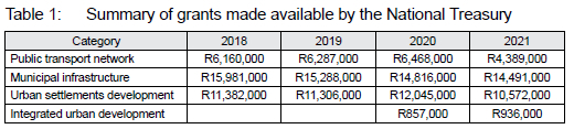
It is interesting to note the reduction in the value of nearly all these grants between 2018 and 2021, which is due, in part, to redirection of funds because of COVID-19. The 2020 Supplementary Budget Review (National Treasury, 2020b: 12) contains details of suspension and redirection of funds in these categories. In 2020, specifically, a new category was introduced (Integrated urban development) with the aim of assisting metropolitan municipalities in building capacity and obtaining support for infrastructure projects. The Cities Support Programme (CSP) (National Treasury, 2022) has played a vital role as change agent in supporting metropolitan municipalities in creating a policy environment that leads to very necessary transformation.
Municipalities receive a Municipal Infrastructure Grant (MIG) (CoGTA, 2022) from the national government to ensure that infrastructure investment is adequate, to enhance the provision of basic services to poorer households, to support long-term planning and budgeting endeavours, and to co-ordinate with national policies that relate to municipal infrastructure.
Section 26 of the Constitution of South Africa (South African Government, 1996: 11) clearly states that every citizen has the right to adequate housing. One can argue about the true definition of adequate housing, but housing should be afforded to everybody. Through the Housing Act 107 of 1997 (South African Government, 1997), the Government introduced a plethora of subsidy programmes aimed at assisting low- and middle-income households to access housing opportunities. The most prominent subsidy programme is the Finance Linked Individual Subsidy Program (FLISP), which is aimed at households with a total household income of between R3,501 and R22,000 (National Housing Finance Corporation, 2019). These households earn too little to obtain a home loan but earn too much to qualify for a free basic house. Human settlement programmes are aimed at providing sustainable human settlements and, in doing so, provide improved quality of life. This is achieved by improving access to accommodation that is adequately located in terms of basic services.
Through the Presidential Infrastructure Coordinating Committee (PICC), the South African Government adopted the NIP in 2012 (South African Government, 2012b). This plan was aimed at radically transforming the economic landscape through job creation and improving basic service delivery by earmarking R827 billion in the national budget for infrastructure investment, upgrading, and maintenance from 2013 onwards. While this was meant as a potential catalyst for major improvement in access to basic and social infrastructure, as well as improvements in economic growth, poverty, unemployment, and inequality are unfortunately still rife.
The New Growth Path (NGP) (South African Government, 2010) was introduced to investigate problems in the economy and identify opportunities for unlocking higher growth with a view to achieving the ambitious target of five million new jobs by 2020. One of the factors identified was the role of infrastructure as the basis for higher growth and job creation.
The committee was tasked with the challenging job of coordinating infrastructure development projects, according to a single NIP, and of monitoring and evaluating progress to ensure momentum, which gave rise to the eighteen SIPs. For the purposes of this article, only the most relevant SIPs are reviewed as found on the website for the NIP (South African Government, 2012b).
In the category of Spatial SIPs, SIP 6 specifically deals with integrated municipal infrastructure projects. Twenty-three districts were identified nationally (with a combined population of roughly nineteen million people) to address backlogs and to improve bulk infrastructure. It also included a road maintenance programme to ensure service-delivery enhancement.
SIP 7, in turn, called for the integration of urban space and public transport. This is a combination of housing and human settlements, with the aim of densification of cities; social infrastructure, with the aim of improved access to social facilities, and public transport infrastructure, with the aim of enhanced mobility. Major progress has been made in terms of urban transport integration through the National Transport Master Plan (NATMAP) (Department of Transport, 2016), with examples being the roll-out of Bus Rapid Transit systems in Gauteng (the City of Tshwane alone spending more than R1.6 billion on this initiative). Other projects include the rehabilitation of townships and the construction of new clinics and schools.
Under the category of Social Infrastructure SIPs, SIP 12 specifically deals with revitalisation of existing healthcare facilities and building large new hospitals. A large amount was budgeted for these facilities to prepare the infrastructure system for the planned National Health Insurance system. SIP 13 focuses on building schools nationally but coupled with it is also a uniform view on procurement management and basic services, whereas SIP 14 focuses on higher education and the infrastructure that supports it. This includes physical classrooms, accommodation for students, libraries, internet access, laboratories, and transport to create university towns with shared facilities.
The Nine Point Plan (South African Government, 2015) was announced in 2015 to further boost economic prospects. This plan proposed steps for addressing very real challenges faced by the country, including in sectors such as energy, agriculture, and minerals, as well as industrial action and infrastructure in sectors such as technology, water, transport, and sanitation.
The Government further developed policy and legislation around these issues in the form of the IUDF (COGTA, 2020) and the Spatial Planning and Land Use Management Act (SPLUMA) of 2013 (DPME, 2020), with the IUDF (COGTA, 2020: 3), in particular, putting forward the four strategic goals of spatial integration, inclusion and access, growth, and governance. SPLUMA, in turn, pursues spatial transformation as well as social and economic inclusion (DPME, 2020: 22).
While the aforementioned plans and legislation provided a directive, there was still a need for guidance on how to implement the plans spatially, which led to the National Spatial Development Framework (NSDF) (DPME, 2020) in 2020 as a strategic spatial plan with a long-term vision towards 2050. The NSDF incorporated, among others, the NDP and SPLUMA as guides and drivers (DPME, 2020: 81-87).
The District Development Model (COGTA, 2021) was also recently introduced by the Government as an operational model for increasing cooperation between the spheres of government and to build a capable, developmental state through joint planning, budgeting, and implementation at a regional level.
It is evident that there are numerous national and regional plans and frameworks that have implications for budgets, projects, and developments related to infrastructure and the built environment. While these plans provide directives to municipalities, they do not give specific guidance on how to achieve the, often grandiose, spatially targeted goals. There is, furthermore, a lack of integrated, national spatial development analyses on the potential implications of growth and subsequent strategic guidance (SACN, 2016: 53). The type of decisions that need to be made include choices regarding the size and location of housing opportunities, in order to improve access to amenities; public transport routes that will enhance mobility and improve access to social facilities, and which infrastructure projects to pursue so as to achieve certain densities in spatially targeted areas, while observing potential growth that can be realised through government-backed development projects. These decisions can all be supported by means of Integrated Land Use Transportation (ILUT) simulation models.
3.2 Statutory requirements on municipalities
A plethora of acts place statutory requirements on municipalities with respect to urban planning. Only the most relevant sections of the acts and accompanying frameworks and instruments are included in the review.
Section 25 of the Municipal Systems Act (MSA) 32 of 2000 (South African Government, 2000: 36) requires each municipality to develop and maintain an IDP; that is, a strategic plan that links, coordinates, and integrates various plans, aligns resources, forms a framework on which to base budget and policy decisions, and complies with national and provincial development plans. The IDP should also communicate the municipal council's vision in terms of long-term municipal development, which includes a critical assessment of existing developments in the city and communities with the most urgent needs for basic municipal services. In essence, the IDP should have been the main instrument to guide strategic spatial development in cities. Some of the critique levelled at the notion of an IDP, however, has been that it focuses too much on compliance and not enough on strategic direction, that it lacks vision, that it has not been aligned with budgets, and that it has struggled to overcome the spatial legacy from apartheid planning (National Treasury, 2018c: 2-4).
Both the MSA and SPLUMA require that each municipality develops a Municipal Spatial Development Framework (MSDF). This framework should incorporate the spatial principles set out in SPLUMA to ensure that the national SDF and the provincial SDF are aligned, that spatial planning leads to economic and social inclusion, and that past imbalances are redressed. The MSDF should contain a five-year spatial development plan for the city, which will influence its spatial form. It should also contain a longer term vision that encapsulates desired spatial growth patterns for up to twenty years into the future. Moreover, the plan should communicate development corridors, economic nodes, population growth estimates, demand for affordable housing, allowed density, and estimates of employment trends coupled with locations within the city. These are all requirements fit for urban growth simulation models to address, since these models are aimed at providing an indication of the long-term effects of these types of interventions and policy on various measures such as future density, growth, and accessibility.
SPLUMA also requires that each municipality has a land-use scheme; that is, a file containing a detailed description of allowed land use within the city and the extent of the urban area (also known as an Urban Growth Boundary), in which development can take place. This scheme must be aligned with the MSDF, in order to promote several aspects such as economic development, social inclusion, efficient development of land, and minimal impact on the environment. It should include regulatory requirements and procedures for land use and development as well as a map depicting the zoning of the municipal area. The specified land use limits the types of development that can take place in specific areas. Urban growth simulation models use these land-use mixes to determine the potential growth per land use and building type in the municipality, which could be very beneficial when determining how best to plan for development.
The MSA further promulgates a requirement on each municipality to develop a CIF, which takes cognisance of national developments and policies (such as in the NDP). A CIF, essentially, targets investment in strategically identified areas, aimed at redressing past spatial planning imbalances - the concept behind spatial transformation. Focused investment is, thus, crucial to ensure spatial transformation and improved service delivery.
It would be useful to take special note of two tools that are used as part of the CIF, namely a capital prioritisation model, which can be used to test the phasing-in of infrastructure projects, and geographic priority areas, which can be used to limit the scope of the study into already identified important areas in the city. Infrastructure projects can be phased in when using urban growth simulation models to determine the best timing and locations thereof. Section 214(1) of the Constitution of South Africa requires an annual division of revenue according to the Division of Revenue Act (DoRA) 9 of 2021 (National Treasury, 2021a) so as to determine how to divide revenue raised nationally between the three spheres of government in an equitable manner. The division of revenue is based on multiple factors such as the powers and functions of each sphere and entity, through which the greatest benefit to the country as a whole can be achieved. The division is also guided by the long-term vision for the country as part of the NDP and the MTSF, which culminate in a Medium-Term Expenditure Framework (MTEF), a budget that is allocated to achieve the long-term goals (National Treasury, 2022).
The DoRA places a statutory requirement on municipalities to submit a BEPP, which is informed by the Built Environment Value Chain (BEVC), as illustrated in Figure 2. The BEPP specifies the details of how grants fund infrastructure projects (partially or fully) as well as planned expenditure for subsequent years. It should also show how expenditure is divided between the municipality's integration zones as opposed to other areas in the city. Urban growth simulation models take into account integration zones and are able to provide measurements of the impact of these planned expenditures on a number of indicators within the integration zones, with a view to show whether the full value of the plans could be unlocked.
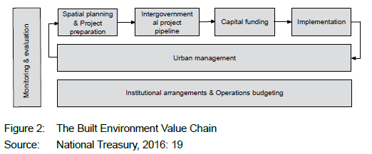
The Cities Support Programme (CSP) of the National Treasury has collaborated with municipalities to enable faster economic growth through spatially targeted investment, identifying catalytic projects to increase densities and integrated land development. This can be viewed as a response to principles as set out in SPLUMA, with the ultimate aim being to align financial resource allocation to development objectives, as is described in the BEVC (National Treasury, 2016: 19).
Metropolitan municipalities followed these requirements and created ambitious plans in 2014 for improving their built environments (National Treasury, 2016: 9). Each of the BEPPs included details of planned integration zones, catalytic projects aimed at higher growth, and investment in other infrastructures. The National Treasury, in collaboration with municipalities, created indicators of improved built-environment performance, which also set targets to be achieved.
Catalytic projects focus on identified areas (nodes/precincts/hubs) that are more densely populated, where land uses are intensified, and where multiple brackets of income groups live together for higher levels of inclusivity. It is also intended to bridge the gap between human settlements planning and public transport, by bringing together the planning of these two domains. These projects, thus, have the potential to have a significant impact on the urban form, although the impact of these projects is not tested before being implemented. ILUT simulation models can greatly assist with trade-offs regarding the locations, sizes, and densities of catalytic projects, as these models are aimed at including all of these elements in an integrated manner.
3.3 Integrated, long-term planning
There are a plethora of acts and planning instruments, but the planning landscape remains exceedingly complex. Unfortunately, the so-called IDP neither adequately 'integrates' the various spatial plans, nor includes the capital investment planning required to realise spatial plans. Plans have become fragmented and new plans have attempted to address the shortcomings of previous plans (National Treasury, 2018c: 5). Furthermore, BEPPs have attempted to deal with some of these problems, but are only used in metropolitan municipalities that constitute a mere eight out of the 278 municipalities in the country.
The IUDF was introduced to provide several policy levers for use as input in other planning instruments as well as to integrate the different instruments (National Treasury, 2018c: 7). The first four policy levers are aimed at integrating urban planning and management, transport and mobility, sustainable human settlements, and urban infrastructure (COGTA, 2020: 4). Through these policy levers, the main aims are manifold. First, to ensure coherent development in cities that improves urban space usage and investment. Secondly, to improve mobility as a catalyst for denser urban form and to provide a means for rural areas to access urban areas. Thirdly, to provide a means to restructure cities, provide a way according to which resources are shared efficiently and enhance inclusivity through an efficient and equitable urban form with higher access to social and economic opportunities.
Policy levers 5 to 9 (National Treasury, 2018c: 8; COGTA, 2020: 5) focus on efficient land governance and management, inclusive economic development, empowered active communities, effective urban governance, and sustainable finances. Their aims are, first, to seek land value increases through spatial transformation that encourage mixed-use development and multifunctional spaces. Secondly, to focus on inclusive economic development so as to create more jobs and encourage innovation with the aim of viable and sustainable communities. Thirdly, to have citizens play a considerable role in a city's success and competitiveness, by helping to shape city growth and contribute to its development. Fourthly, to have the three spheres of government working together to achieve mandates. Finally, to run well-managed finances through proper revenue and expenditure as well as focused investment in infrastructure.
As part of sharpening the planning instruments, numerous improvements of the levers of the IUDF have been suggested, of which the most prominent ones include:
• Creating compact cities and connected cities (National Treasury, 2018c: 11-12). Density plays an important part in the viability of public transport networks and there should be alignment of housing and transport planning to ensure that the required densities are reached along transport corridors. Furthermore, brownfields (land that has been used previously but is not currently used) should be prioritised for development over greenfields (land that has never been used previously). Environmentally sensitive land and high-value agricultural land should be preserved and protected as far as possible. Zoning schemes should be updated to encourage mixed-use developments and an intensification of land use.
• Prioritisation of access to social infrastructure (National Treasury, 2018c: 13). New public transport routes should be designed in such a way as to improve access to social infrastructure, which includes educational, health, recreational, and government services.
• Upgrading of informal settlements (National Treasury, 2018c: 13). IDPs must prioritise the upgrading of informal settlements and the budgets that accompany these projects.
• Inner-city regeneration (National Treasury, 2018c: 13). Where possible, inner-city regeneration should be prioritised by means of affordable housing projects. The most prominent areas should be prioritised for this purpose and properties should be acquired timely to enable such developments.
• Provision of additional options for accessing urban opportunities (National Treasury, 2018c: 14). By creating greater variety within the housing stock, more urban opportunities would be available. This should also lead to a better mix of income levels within a city. The land-use management should be such that different settlement typologies are made available, and this should include affordable rental options.
• Promotion of densification initiatives (National Treasury, 2018c: 14). Backyard structures and additions should be allowed to obtain higher densities in cities. Further development of erven to allow for a second dwelling should also be allowed. Moreover, high-rise developments should be encouraged in suitably located areas.
• Strengthening of land-use planning and management (National Treasury, 2018c: 16). Land-use planning and management should be enhanced with a view to include all groups of society. Housing projects on the periphery of a city should be limited.
When necessary, the IDP should be revised in terms of Section 33 of the MSA (South African Government, 2000: 44) to consider revenue and expenditure projections resulting from national and provincial allocations, as well as the division of revenue. Accordingly, the Service Delivery and Budget Implementation Plan (SDBIP) should detail the service delivery implementation and the associated budget in terms of Section 53 of the Municipal Finance Management Act (MFMA) 56 of 2003 (South African Government, 2003: 68).
The Integrated Public Transport Network (IPTN) (National Treasury, 2018b) assists cities that receive public transport grants with public transport planning. The conditions for the grant, as set out by the DoRA, are that cities should develop a sustainable and integrated public transport network. The IPTN is a long-term perspective (twenty or more years) of a city-wide plan for public transport network development. The National Land Transport Act (NLTA) 5 of 2009 (South African Government, 2009) also requires an Integrated Transport Plan (ITP) or Comprehensive Integrated Transport Plan (CITP) in the case of larger municipalities. ILUT models can also assist in this regard, integrating public transport networks, by including future versions of the networks in the models, in order to determine the effect that network planning will have on other patterns in municipalities such as accessibility and location choices.
Unfortunately, local-level plans and short- to medium-term planning instruments in South African municipalities still lack the consideration of climate change (Pieterse, Du Toit & Van Niekerk, 2021: 506). Climate response outcomes could be included by integrating climate change adaptation into planning documents, processes, and budgets (Van Niekerk, Pieterse and Le Roux, 2020: 115). This would, however, add further complexity with regard to decisions and trade-offs. Ford et al. (2018: 5) argued that ILUT models allow decision-makers to explore the spatial context of urban futures while analysing environmental, economic, and social sustainability aspects; this provides the means to develop plans consistent with climate change adaptation endeavours.
3.4 The need to test interventions
The aforementioned acts and planning instruments individually and collectively result in a very complex planning environment. Unfortunately, these acts and planning instruments pertain to ideal environments and ideal cities, but they often neglect evidence-based decision-making as part of the endeavour to achieve such cities or else use short-term, operational models with limited futuristic projections to determine the sustainability of solutions. There is no requirement for planned policy interventions to be tested before being adopted as policy, or before being used as a guideline for development, which poses various challenges. First, without a sound evidence base to work from, decisions will be based merely on subjective reasoning or political will, with debates structured around the specific government department's goal. This will further lead to fragmentation and poor coordination of planning initiatives, as was also argued by Turok & Parnell (2009: 164). Secondly, there is no means to test the likely outcome of changes in policy (allowable densities, locations and sizes of housing projects, expansion of public transport services, limiting sprawl) on forward projected indicators related to spatial inequality, achievable densities, commuting distances, and climate-related indicators without a simulation model. Thirdly, there is no guidance in terms of how to reach certain targets, let alone whether the targets are even reachable. Long-term visions, coupled with spatial outcomes, are too generic and do not contain place-specific strategies, backed up by budgets that fund projects within these areas; there is an overall lack of evidence-based planning (SACN, 2020: 13).
In order to be able to test tradeoffs in the locations and sizes of development projects and to determine the likely effect that these might have on future densities, accessibility, and demand requires a simulation model capable of both incorporating the development dynamics in an appropriate manner, and providing the necessary decision support in terms of the type of analyses that can be executed when using the model.
3.5 Simulation as a tool to test interventions
There are various types of models with which to test interventions in urban planning. This section is an overview of the different types of models and their implementations in the local context, accompanied by the limitations thereof.
Cilliers (2010) performed a multi-criteria analysis to develop a model for urban growth of Potchefstroom in the North-West province. He analysed conflicts and land-use suitability, considering different land uses such as urban, agriculture, and conservation. The study showed that data existed to perform urban growth modelling when it is not too complex in nature.
Cilliers & Drewes (2010: 3) argued that the natural environment should be considered during planning processes and the formulation of SDFs so as to protect the environment and best achieve the SDGs. A GIS-based approach was adopted, and a favourable outcome was achieved in terms of providing planners with a pro-active approach to land-use management, although this was only at a strategic level and not at a micro level with inherent behaviour captured. From a behavioural angle, Shoko and Smit (2013) applied an agent-based model to patterns and trends in land occupation that change over time in Cape Town. The model also included informal settlements as well as physical and socio-economic factors.
Le Roux (2012) implemented Dyna-CLUE (a cellular-automata model) to investigate the consequences of planning policies within the City of Johannesburg. Spatial policies were considered together with land-use maps as well as macro-economic and demographic factors. Le Roux and Augustijn (2015) further adjusted the model to test two policy scenarios and presented useful results that could inform policy. Similarly, Ludick and Le Roux (2018) tested policy scenarios for the City of Tshwane, adapting and applying the 'What If model. Tizora et al. (2018) applied the Dyna-CLUE model in the Western Cape province to simulate land-use changes at provincial scale. Le Roux and Augustijn (2017: 31) argued that most of the models applied in South Africa do not include various land-use classes nor do they take into account the effect of policy scenarios on land-use change.
Abutaleb et al. (2013) implemented a cellular-automata model to predict urban growth within the City of Johannesburg. The model was calibrated on data from the period 1995-2010, by using satellite imagery to determine land cover, and this was subsequently used to model urban growth. Cilliers, Van Vuuren and Van Heerden (2021) developed a framework for modelling and predicting informal settlement growth using cellular-automata and machine learning techniques, resulting in very favourable model performance. Tamuka Moyo, Zuidgeest and Van Delden (2021) coupled a cellular-automata model with a four-step transportation model to address issues of social and economic exclusion of marginalised groups. While cellular-automata models are useful, they do not contain behavioural elements such as decisions by, and interaction between, role players, which limits their application.
Pfeiffer et al. (2019) built a standard urban economics land-use model that included formal and informal housing markets. They assessed the effectiveness of subsidised housing schemes and urban growth boundaries in the City of Cape Town.
A growth potential modelling technique was adopted by Van Niekerk et al. (2016). It provided insight into which settlements are the most likely to experience growth. Yet, a drawback is that the set of criteria adopted is not universally agreed upon, which makes it hard to determine the accuracy of the results (Van Niekerk et al., 2016: 180). The authors combined multi-criteria decision-making, GIS, and planning support systems to set up urban growth scenarios for the Western Cape. They showed how this combination of techniques can be used to assess scenarios related to urban growth.
Specific consulting companies also have a strong presence in the decision-support space with respect to planning practices. For example, Novus 3 (2021) uses both qualitative and quantitative information to assist cities in determining how projects should be implemented within their planned budgets. It further provides decision support on the reporting that goes with the implementation of capital projects so as to adhere to legislative requirements. Through economic impact models, it provides insights into what the effects would be when specific projects were to be implemented. While all of these are useful in an operational sense, hardly any insight is gained into the longer term impact or what to do in order to achieve any long-term future goals.
Palmer Development Group (2021) is another entity operating in this space, which provides financial and strategic decision support to municipalities. These include tariffs, property rates, grants, and financial modelling such as infrastructure investment planning tools and the financial viability of these projects. The group is multifaceted, carrying out research, policy development, and spatial planning, coupled with economics and public transport studies. Yet, a long-term, futuristic outlook is still lacking.
There are very few cases in South Africa, where land-use change and climate change adaptation have been considered simultaneously. Jagarnath, Thambiran and Gebreslasie (2019) developed a model using Land Change Modeler to model future urban land changes that inform climate-change planning.
The authors tested three scenarios: A business as usual scenario, a protecting green infrastructure scenario, and a densification along transport corridors scenario (Jagarnath et al., 2019: 8). While this study is a step towards linking land-use change modelling with climate-change adaptation, the model unfortunately lacks many elements required for scenario development that could influence policy. First, role players and their decisions are neglected. Secondly, it does not seem to include behavioural elements such as real-estate market supply and demand, being able to specify new land-use mixes with varying allowable densities, travel patterns and costs, potential development projects, and occupancy levels of buildings. Lastly, it is strongly linked to past spatial patterns; a phenomenon that could cause future versions of the study area to exhibit spatial patterns inherited from the past. Waldeck, Van Heerden and Holloway (2020: 233) warned that careful consideration should be given to distinguish between observed patterns that are remnants from the past versus actual preferences. In order not to perpetuate the situation, the model should rather be estimated using different variables or a subset of the data.
Ford et al. (2018: 15) advocated for the use of ILUT models in testing the effectiveness of climate adaptation options, as most of these interventions require knowledge of future land-use patterns, infrastructure development, and travel patterns.
The Council for Scientific and Industrial Research (CSIR) started exploring the possibility of implementing UrbanSim in South Africa in 2006. Coetzee et al. (2015) provided an overview of the early development and implementations of the model, more specifically within the context of assisting the Department of Science and Technology to better plan for future development patterns and to inform long-term planning policy. The authors argued that infrastructure investment decisions should be grounded in rigorous, evidence-based analysis, coupled with scenario development (Coetzee et al., 2015: 8), and provide results from a number of case studies to highlight the usefulness of this approach as it provides future patterns of demand to use during planning for infrastructure and facilities, economic infrastructure investments, and possible effects on the sustainability of cities.
Waldeck et al. (2020) described the value of ILUT models in metropolitan planning processes. They focused on the role of urban growth modelling in policy decision support related to investment in social and economic infrastructure, by providing results of case studies carried out between 2013 and 2017 in three cities: Nelson Mandela Bay, Tshwane, and Ekurhuleni. Waldeck and Van Heerden (2017) further explained the use of Integrated Land-Use and Transportation modelling in developing countries, with an emphasis on how transport costs impact on low-income households. They used a combination of UrbanSim and OpenTripPlanner to illustrate the effects of different policies on future spatial patterns in the city. The modelling capability was developed further as part of the Spatial and Temporal Evidence for Planning (StepSA, 2021) initiative, which was aimed at providing much needed analyses to bring about evidence-based decision-making with respect to infrastructure investment in South African cities, towns, and settlements. Examples include:
• The impact of government-funded housing projects and how location decisions can inform future BEPP processes (Waldeck, Van Heerden & Holloway, 2020: 246);
• Trade-offs between large government-funded housing projects and in-fill development in Ekurhuleni (Waldeck et al., 2020: 246), and
• The impact on the Long-Term Financial Sustainability Plan of Nelson Mandela Bay (Waldeck et al., 2020: 248). Waldeck et al. (2020: 251) showed that policy decisions can be influenced, when using ILUT models, by means of rational analysis and hypothesis testing and that ILUT models tend to be the most representative of the dynamics found in the planning environment.
4. DISCUSSION
4.1 The need for an improved modelling technique
While many case studies are available in the literature that highlight the value of simulation models as part of planning processes, there is still a lack of uptake as part of planning instruments. One of the reasons might be that ILUT models are notoriously hard to develop. Another reason might be that these models only provide a means to test 'what-if' scenarios; the decision maker is required to develop numerous scenarios, in order to ascertain the possible effect of policy changes, which could be cumbersome. There is a need for an improved modelling technique. Backcasting is a technique that lets decision-makers define a future state to be met, with the aim of working backwards to determine which policies might help them achieve that future state (Ford et al., 2018: 9). The drawback is still that it leaves the decision-maker with the laborious task of testing numerous combinations of policy options manually.
4.2 A simulation-optimisation framework
While there is evidence of South African cities and the Gauteng Provincial Government using simulation models to guide decisions as part of their planning processes (CSIR, 2022; City of Tshwane, 2020: 59), there is still considerable potential for its uptake and use in various other planning processes which also include consideration of climate change adaptation.
Furthermore, many departments know what they want to achieve, but not necessarily how to achieve their goals nor whether the goals are even achievable. A simulation-optimisation approach could provide this type of support.
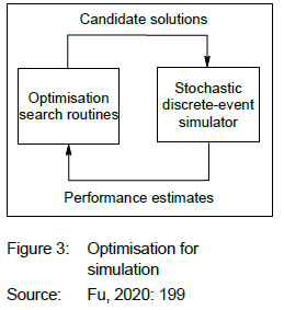
Simulation-optimisation presents modellers with a relatively new capability of enhanced decision support, as shown in Figure 3 (Fu, 2002). It is essentially the introduction of optimisation techniques with a view to enhancing the solution(s) emanating from a simulation model, where these solutions are evaluated in terms of an objective function or fitness function. During the normal 'what-if' process of modelling, hundreds of simulation model replications/ scenarios would potentially have to be set up and considered, in order to obtain a desirable outcome/ target, since the user would not know beforehand whether the changes will indeed ensure that the target is reached. Therefore, introducing an optimisation component that can test numerous simulations autonomously, could assist significantly in finding pathways toward achieving a specified goal.
An example of this type of modelling approach was presented by Popp et al. (2017), who showed how different land uses affect greenhouse gas emissions and subsequently derived land-based mitigation scenarios. Caparros-Midwood, Barr and Dawson (2015: 157) developed a spatial optimisation framework, in which the locations of residential development are optimised to achieve several sustainability measures. The results were compared against individual objectives, pairs of objectives, and multiple objectives. The authors showed that their approach outperformed all the other strategies, including local authority strategies.
Adopting a simulation-optimisation approach, as advocated in this section, could thus provide much-needed decision support to various departments that wish to determine how to reach certain targets. Some examples are provided next, with the final example dedicated to climate change adaptation.
4.3 Simulation-optimisation blueprints
4.3.1 Land release for further development
With the debate on the rapid release of land for accelerated development, questions arise as to whether the South African Government can make government-owned land available and, more importantly, where and when this should occur. Figure 4 presents a graphical overview of how such a scenario may be tested in a simulation-optimisation environment.
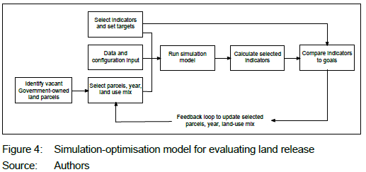
First, one should identify the land parcels that are government-owned, together with their metadata related to location, size, land use, etc. It is acknowledged that it might be difficult to obtain such data, which necessitates a budget and resources to identify government-owned land adequately (be it national government or municipal). From this, a first selection of parcels can be made with a land-use mix specified. Together with other data sets, this could be presented to the simulation model, from which the outputs and selected indicators could be calculated. In this instance, densities in specific areas and accessibility measures could provide good decision support. The indicators should then be compared with the targets set for these indicators. The optimisation algorithm will automatically test different combinations of parcels selected, the associated land-use mix, and the eventual effects on indicators at the end of the simulation. The algorithm will learn how the inputs influence the outputs and eventually deliver the best set of parcels, land-use mix, and timing to get as close as possible to the targets specified. It is not guaranteed that the targets will be met, but the approach would provide the best opportunity of reaching the targets with minimal user input.
4.3.2 Facility location planning
A similar approach may be followed for facility location planning. Whereas most of the facility location problems are solved by means of a static optimisation process (meaning that future demand is estimated a priori and that the optimal future locations for facilities are determined based on these estimates), a simulation-optimisation approach could enhance the solutions, by following an evaluation process, as illustrated in Figure 5.
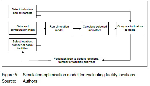
A first selection of locations and number of facilities could be made. Together with other data sets, this could again be presented to the simulation model, from which the outputs and selected indicators could be calculated. In this instance, accessibility measures would provide good decision support. The indicators should then be compared with the targets set for these indicators and the algorithm will automatically test different combinations of locations, numbers of facilities, and years of implementation, as well as the eventual effects on indicators at the end of the simulation. The algorithm will learn how the inputs influence the outputs and eventually deliver the best set of locations, number of facilities, and years of implementation to achieve the targets.
The added benefit of this approach over traditional modelling approaches is that the newly 'built' facilities in the simulation model will also act as attractors during the simulation, which will influence households' choices as to where they decide to live. The subsequent effects on household distributions and the supply and demand of housing could also be tested, apart from attempting to improve accessibility to social facilities.
4.3.3 Land-use mix and spatial targeting
The third example is similar to the one described in Section 4.3.1, with the difference being that government-owned land is not included. Instead, the algorithm will choose from available vacant land to implement different land-use mixes, which will influence what building types can be developed by developers, as depicted in Figure 6.

In this case, the algorithm will attempt to obtain the best land-use mix to apply to various zones in the study area, with a view to achieving the targets set for the indicators in question.
4.3.4 Integrating urban planning and climate change
The final simulation-optimisation model workflow, provided in Figure 7, is an attempt to exemplify the argument presented earlier in the paper of Ford et al. (2018:5) that ILUT models could allow decision-makers to explore future spatial contexts and environmental aspects simultaneously. It also provides an example of how ILUT models could be used to test the coherent approaches advocated by Pieterse et al. (2021: 506), by introducing urban planning- and climate change-related indicators as part of a suite of indicators to trade off against one another. In this example, the land-use mix could again be set per zone as well as according to the allowable density per building type. A subset of potential development projects could be chosen to be implemented. These projects could typically form part of SDFs or other Master Plans. After the simulation has been run, four indicators could be calculated pertaining to urban planning and climate change. The algorithm will eventually provide a set of possible solutions that would be as close as possible to the targets set. This is useful to trade off having higher densities and accessibility to amenities (considered to be good for urban planning) with the risk and vulnerability of households that could be in a flood zone and the possible energy usage in different areas of the municipality (considered risky from a climate change point of view). This is but one example, and there are many other possibilities, according to which different objectives could be traded off against one another.
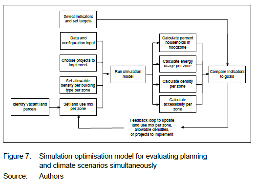
It is acknowledged that this type of model could very rapidly become very complex, but with the computing power at our disposal, running multiple simulations in parallel may well render the approach tractable.
4.4 Concluding remarks on simulation-optimisation
In the previous sections, the value of using simulation as a tool for decision support in local-level planning was presented. The ILUT model, in particular, stood out, as it encapsulates the different stakeholders and decision-makers in municipalities as well as the interaction between them - the behavioural element that many other types of simulation model lack. ILUT models in themselves are, however, limited in the types of questions they can answer. By incorporating an optimisation element, additional capability may be provided, as was shown in Sections 4.3.1 to 4.3.4. The simulation-optimisation methodology allows decision-makers to set targets, which may then guide the optimisation algorithms to find the best configuration of input parameters used in the simulation so as to achieve the desired outcome. This is especially useful when decision-makers know what they would like to achieve (for example, spatial targets, densities, accessibility levels, and energy usage levels) but not necessarily how to achieve these, and it removes the need for the modeller to run multiple simulations, since the algorithm does this autonomously.
5. CONCLUSION
The National Government has introduced numerous national plans over the past two decades as policy levers during attempts to develop more inclusive municipalities. Whereas some plans have delivered favourable results, development did not take place adequately in many other instances. Integration between different spheres of government is also still too inefficient, with various plans introduced in attempts to foster cooperation and alignment. Furthermore, very few local-level plans consider climate change adaptation.
The plethora of acts and legislature that govern municipalities introduce further complexities at local level, with adherence requirements increasing and budgets decreasing. Many instruments and frameworks assist municipalities to better align and coordinate infrastructure investment, but planning remains fragmented in many instances. None of the acts require municipalities to test policy interventions before implementation and instruments rarely mention the use of modelling as part of the decision-making process. This has resulted in many unintended consequences such as goals not being reached and uncoordinated development taking place.
Many simulation models have been developed for this purpose, although ILUT models still seem to be the most representative of the dynamics found in municipalities. Furthermore, the typical 'what-if' way of modelling seems to be cumbersome and an improved simulation-optimisation approach was advocated in this article that could provide local authorities with a new capability of determining how to achieve sustainable targets set out. This is especially useful, since many government departments know what they would like to achieve, but often find it difficult to determine how to achieve these targets, let alone assess whether their achievement is even possible. Such an enhanced model will allow various departments to set targets and the overarching optimisation algorithm will determine, by simulation, whether and how the targets could be achieved by trading the various goals off against one another.
While this type of modelling would be useful to decision-makers and planners, it needs to go hand in hand with capacity development and an adequate budget to ensure uptake within municipalities. It is recommended that budgets should include funding for simulation models, especially so if climate targets are to be reached and pathways need to be found in order to do so. It is acknowledged that budgets are already severely constrained, but the financial impact of not testing policy or interventions could far outweigh the cost of setting up simulation models, not to mention the detrimental effect of not acting in the wake of climate change. Furthermore, once the simulation models have been set up, the maintenance thereof would become less costly and less involved.
While this article focused on housing, transportation, and infrastructure, various other aspects can be tested in a similar way, by linking these domains to urban growth. Examples include, among others, optimal freight network design, revenue modelling, risk mitigation, and disaster management.
REFERENCES
ABUTALEB, K., TAIWO, O., AHMED, F. & NGIE, A. 2013. Modeling urban change using cellular automata: The case study of Johannesburg, South Africa. In: Proceedings of the IGU Urban Geography Commission, 21-26 July, Johannesburg, pp. 64-76. [ Links ]
CAPARROS-MIDWOOD, D., BARR, S. & DAWSON, R. 2015. Optimised spatial planning to meet long-term urban sustainability objectives. Computers, Environment and Urban Systems, 54, pp. 154-164. https://doi.org/10.1016/j.compenvurbsys.2015.08.003 [ Links ]
CILLIERS, D.P. 2010. The development and use of a land-use suitability model in spatial planning in South Africa. Unpublished Masters dissertation. North-West University, South Africa. [ Links ]
CILLIERS, D. & DREWES, E. 2010. Land-use suitability modelling as an input for spatial planning in Tlokwe local municipality, North-West province, South Africa. Town and Regional Planning, 57, pp. 1-12. [ Links ]
CILLIERS, P., VAN VUUREN, J. & VAN HEERDEN, Q. 2021. A framework for modelling spatiotemporal informal settlement growth prediction. Computers, Environment and Urban Systems, 90, pp. 1-15. https://doi.org/10.1016/j.compenvurbsys.2021.101707 [ Links ]
CITY OF TSHWANE. 2020. Tshwane Metropolitan Spatial Development Framework 2030. [Online]. Available at: <https://bit.ly/3iWRlQV> [Accessed: 1 June 2022]. [ Links ]
COETZEE, M. (f 2 NOVEMBER 2014), WALDECK, L., LE ROUX, A., MEIKLEJOHN, C., VAN NIEKERK, W. & LEUTA, T. 2014. Spatial policy, planning and infrastructure investment: Lessons from urban simulations in three South African cities. Town and Regional Planning, 64, pp. 1-9. [ Links ]
COGTA (COOPERATIVE GOVERNANCE AND TRADITIONAL AFFAIRS). 2020. South Africa's national urban development policy - the IUDF. [Online]. Available at: <https://iudf.co.za/wp-content/uploads/2020/09/IUDF-Brochure.pdf> [Accessed: 1 June 2022]. [ Links ]
COGTA (COOPERATIVE GOVERNANCE AND TRADITIONAL AFFAIRS). 2021. District Development Model. [Online]. Available at: <https://www.cogta.gov.za/ddm/> [Accessed: 30 November 2021]. [ Links ]
COGTA (COOPERATIVE GOVERNANCE AND TRADITIONAL AFFAIRS). 2022. Municipal Infrastructure Grant. [Online]. Available at: <https://www.cogta.gov.za/mig/> [Accessed: 1 June 2022]. [ Links ]
CSIR (COUNCIL FOR SCIENTIFIC AND INDUSTRIAL RESEARCH). 2022. Land-use transportation interaction model helps plan for sustainable urban growth and infrastructure investment. [Online]. Available at: <https://bit.ly/3BugngZ> [Accessed: 1 June 2022]. [ Links ]
DEPARTMENT OF TRANSPORT. 2016. National Transport Master Plan 2050 Synopsis Report. [Online]. Available at: <http://www.transport.gov.za/natmap-2050> [Accessed: 30 November 2021]. [ Links ]
DFFE (DEPARTMENT OF FORESTRY, FISHERIES & THE ENVIRONMENT). 2020. National Climate Change Adaptation Strategy. [Online]. Available at: <https://bit.ly/3FJqMru> [Accessed: 30 June 2022]. [ Links ]
DPME (DEPARTMENT OF PLANNING, MONITORING AND EVALUATION). 2020. Draft National Spatial Development Framework. [Online]. Available at: <https://bit.ly/2UkGUVO> [Accessed: 1 June 2022]. [ Links ]
DPME (DEPARTMENT OF PLANNING, MONITORING AND EVALUATION). 2021. MTSF Comprehensive Document. [Online]. Available at: <https://bit.ly/3WcfP7a> [Accessed: 30 November 2021]. [ Links ]
FORD, A.C., DAWSON, R.J., BLYTHE, P.T. & BARR, S. 2018. Land-use transport models for climate change mitigation and adaptation planning. Journal of Transport and Land Use, 11(1), pp. 83-101. https://doi.org/10.5198/jtlu.2018.1209 [ Links ]
FU, M.C. 2002. Optimization for simulation: Theory vs. practice. INFORMS Journal on Computing, 14(3), pp. 192-215. https://doi.org/10.1287/ijoc.14.3.192.113 [ Links ]
IMF (INTERNATIONAL MONETARY FUND). 2020. Six charts explain South Africa's inequality. [Online]. Available at: <https://bit.ly/3BsiLET> [Accessed: 1 June 2022]. [ Links ]
JAGARNATH, M., THAMBIRAN, T. & GEBRESLASIE, M. 2019. Modelling urban land change processes and patterns for climate change planning in the Durban metropolitan area, South Africa. Journal of Land Use Science, 14(1), pp. 81-109. https://doi.org/10.1080/1747423X.2019.1610809 [ Links ]
KENNEDY, C., PINCET, S. & BUNJE, P. 2011. The study of urban metabolism and its applications to urban planning and design. Environmental Pollution, 159(8-9), pp. 1965-1973. https://doi.org/10.1016/j.envpol.2010.10.022 [ Links ]
LE ROUX, A. 2012. Quantifying the spatial implications of future land-use policies in South Africa: Reshaping a city through land-use modelling. Master's thesis, University of Utrecht, The Netherlands. [ Links ]
LE ROUX, A. & AUGUSTIJN, P.W.M. 2015. Quantifying the spatial implications of future land-use policies in South Africa. South African Geographical Journal, 99(1), pp. 29-51. https://doi.org/10.1080/03736245.2015.1117014 [ Links ]
LUDICK, C. & LE ROUX, A. 2018. A geospatial modelling approach to simulating the impact of future planning policies on the City of Tshwane. In: Proceedings of the AfricaGEO 2018 Conference, 17-19 September, Kempton Park, pp. 38-51. [ Links ]
NATIONAL HOUSING FINANCE CORPORATION. 2019. FLISP overview. [Online]. Available at: <https://www.nhfc.co.za/finance-solutions/finance-linked-individual-subsidy-finance-flisp/> [Accessed: 1 June 2022]. [ Links ]
NATIONAL TREASURY. 2016. Cities Support Programme: Guidance note for the Built Environment Performance Plan. [Online]. Available at: <https://bit.ly/3W2LqbG> [Accessed: 30 November 2021]. [ Links ]
NATIONAL TREASURY. 2018a. 2018 National Budget Review. [Online]. Available at: <http://www.treasury.gov.za/documents/national%20budget/2018/review/Chapter%206.pdf> [Accessed: 30 November 2021]. [ Links ]
NATIONAL TREASURY. 2018b. Cities Support Programme: Integrated Public Transport Network (IPTN) plan development technical guidance version 4. [Online]. Available at: <https://bit.ly/3uEZbBA> [Accessed: 30 November 2021]. [ Links ]
NATIONAL TREASURY. 2018c. Cities Support Programme: Sharpening the planning tools. [Online]. Available at: <https://bit.ly/3FJgwPT> [Accessed: 30 November 2021]. [ Links ]
NATIONAL TREASURY. 2019. 2019 National Budget Review. [Online]. Available at: <http://www.treasury.gov.za/documents/national%20budget/2019/review/FullBR.pdf> [Accessed: 30 November 2021]. [ Links ]
NATIONAL TREASURY. 2020a. 2020 National Budget Review. [Online]. Available at: <http://www.treasury.gov.za/documents/national%20budget/2020/review/FullBR.pdf> [Accessed: 30 November 2021]. [ Links ]
NATIONAL TREASURY. 2020b. 2020 Supplementary Budget Review. [Online]. Available at: <http://www.treasury.gov.za/documents/national%20budget/2020s/review/fullsbr.pdf> [Accessed: 30 May 2022]. [ Links ]
NATIONAL TREASURY. 2021a. The Division of Revenue Act, 9 of 2021. [Online]. Available at: <https://www.gov.za/sites/default/files/gcis_document/202106/divisionofrevenueact9of2021.pdf> [Accessed: 1 June 2022]. [ Links ]
NATIONAL TREASURY. 2021b. 2021 National Budget Review. [Online]. Available at: <http://www.treasury.gov.za/documents/National%20Budget/2021/review/FullBR.pdf> [Accessed: 30 November 2021]. [ Links ]
NATIONAL TREASURY. 2022. Cities Support Programme. [Online]. Available at: <https://bit.ly/3UTQjm6> [Accessed: 1 June 2022]. [ Links ]
NOVUS3. 2021. Novus3. [Online]. Available at: <https://www.novus3.co.za/services> [Accessed: 30 November 2021]. [ Links ]
NPC (NATIONAL PLANNING COMMISSION). 2020a. A review of the National Development Plan 2030. [Online]. Available at: <https://bit.ly/3W7VMXB> [Accessed: 1June 2022]. [ Links ]
NPC (NATIONAL PLANNING COMMISSION). 2020b. Economic progress towards the national development plan's vision 2030. [Online]. Available at: <https://bit.ly/3WcQnPc> [Accessed: 1June 2022]. [ Links ]
PALMER DEVELOPMENT GROUP. 2021. Palmer Development Group. [Online]. Available at: <https://pdg.co.za/what-we-do> [Accessed: 30 November 2021]. [ Links ]
PFEIFFER, B., RABE, C., SELOD, H. & VIGUIE, V. 2019. Assessing urban policies using a simulation model with formal and informal housing: Application to Cape Town, South Africa. Policy Research Working Paper No. 8921. Washington: The World Bank. https://doi.org/10.1596/1813-9450-8921 [ Links ]
PIETERSE, A., DU TOIT, J. & VAN NIEKERK, W. 2021. Climate change adaptation mainstreaming in the planning instruments of two South African local municipalities. Development Southern Africa, 38(4), pp. 493-508. https://doi.org/10.1080/0376835X.2020.1760790 [ Links ]
PIETERSE, A., VAN NIEKERK, W. & DU TOIT, J. 2018. Creating resilient settlements through climate change adaptation planning. Presented at the Planning Africa Conference, 15-17 October, Cape Town, South Africa. [ Links ]
PILLAY, U. 2008. Urban policy in post-apartheid South Africa: Context, evolution, and future directions. Urban Forum, 19, pp. 109-132. https://doi.org/10.1007/s12132-008-9038-5 [ Links ]
POPP, A., CALVIN, K., FUJIMORI, S., HAVLIK, P., HUMPENÖDER, F., STEHFEST, E., et al. 2017. Land-use futures in the shared socio-economic pathways. Global Environmental Change, 42, pp. 331-345. https://doi.org/10.1016/j.gloenvcha.2016.10.002 [ Links ]
SACN (SOUTH AFRICAN CITIES NETWORK). 2016. The spatial transformation of South Africa's cities. [Online]. Available at: <http://www.socr.co.za/wp-content/uploads/2016/06/SoCR16-MainReport_02Spatial.pdf> [Accessed: 1 June 2022]. [ Links ]
SACN (SOUTH AFRICAN CITIES NETWORK). 2020. Spatial strategies alignment discussion paper. [Online]. Available at: <https://bit.ly/3uKYFlE> [Accessed: 1 June 2022]. [ Links ]
SDSN (SUSTAINABLE DEVELOPMENT SOLUTIONS NETWORK). 2016. Getting started with the SDGs in cities. A guide for stakeholders. [Online]. Available at: <https://resources.unsdsn.org/getting-started-with-the-sdgs-in-cities> [Accessed: 30 October 2021]. [ Links ]
SHOKO, M. & SMIT, J. 2013. Use of agent-based modelling to investigate the dynamics of slum growth. South African Journal of Geomatics, 2(1), pp. 54-67. [ Links ]
SOUTH AFRICAN GOVERNMENT 1996. Constitution of the Republic of South Africa, Act No. 108 of 1996. Pretoria: Government Printer. [ Links ]
SOUTH AFRICAN GOVERNMENT 1997. Housing Act, 107 of 1997. Pretoria: Government Printer. [ Links ]
SOUTH AFRICAN GOVERNMENT 2000. Local Government: Municipal Systems Act, 32 of 2000. Pretoria: Government Printer. [ Links ]
SOUTH AFRICAN GOVERNMENT 2003. Local Government: Municipal Finance Management Act, 56 of 2003. Pretoria: Government Printer. [ Links ]
SOUTH AFRICAN GOVERNMENT. 2009. National Land Transport Act, 5 of 2009. Pretoria: Government Printer. [ Links ]
SOUTH AFRICAN GOVERNMENT. 2010. The New Growth Path Framework. [Online]. Available at: <https://www.gov.za/about-government/government-programmes/new-growth-path> [Accessed: 1 June 2022]. [ Links ]
SOUTH AFRICAN GOVERNMENT. 2012a. The National Development Plan. [Online]. Available at: <https://bit.ly/3VS1YTM> [Accessed: 30 November 2021]. [ Links ]
SOUTH AFRICAN GOVERNMENT. 2012b. The National Infrastructure Plan. [Online]. Available at: <https://bit.ly/3YgJAFH> [Accessed: 30 November 2021]. [ Links ]
SOUTH AFRICAN GOVERNMENT. 2014. National Planning Commission: Diagnostic Overview. [Online]. Available at: <https://www.gov.za/sites/default/files/gcis_document/201409/npcdiagnosticoverview1.pdf> [Accessed: 1 June 2022]. [ Links ]
SOUTH AFRICAN GOVERNMENT. 2015. The Nine Point Plan. [Online]. Available at: <https://www.gov.za/issues/nine-point-plan> [Accessed: 30 November 2021]. [ Links ]
STEPSA. 2021. Spatial and temporal evidence for planning in South Africa. [Online]. Available at: <http://stepsa.org/simulating_the_future.html> [Accessed: 30 November 2021]. [ Links ]
TAMUKA MOYO, H.T., ZUIDGEEST, M. & VAN DELDEN, H. 2021. Lessons learned from applying an integrated land-use transport planning model to address issues of social and economic exclusion of marginalised groups: The Case of Cape Town, South Africa. Urban Science, 5(1), pp. 1-23. https://doi.org/10.3390/urbansci5010010 [ Links ]
TIZORA, P., LE ROUX, A., MANS, G. & COOPER, A. 2018. Adapting the Dyna-CLUE model for simulating land use and land cover change in the Western Cape Province. South African Journal of Geomatics, AfricaGEO 2018 Special Edition, 7(2), pp. 190-203. https://doi.org/10.4314/sajg.v7i2.7 [ Links ]
TUROK, I. 2016. South Africa's new urban agenda: Transformation or compensation? Local economy, 31(1-2), pp. 9-27. https://doi.org/10.1177/0269094215614259 [ Links ]
TUROK, I. & PARNELL, S. 2009. Reshaping cities, rebuilding nations: The role of national urban policies. Urban Forum, 20(2), pp. 157-174. https://doi.org/10.1007/s12132-009-9060-2 [ Links ]
UN (UNITED NATIONS). 2019. Transforming our world: The 2030 agenda for sustainable development. [Online]. Available at: <https://bit.ly/3iWb43t> [Accessed: 30 October 2021]. [ Links ]
UN HABITAT 2022. World Cities Report 2022. [Online]. Available at: <https://unhabitat.org/sites/default/files/2022/06/wcr_2022.pdf> [Accessed 30 June 2022]. [ Links ]
VAN HEERDEN, Q. 2020. Urban growth modelling and simulation: Learning from the past, applying in the present, and dreaming of the future. [Online]. Available at: <https://www.ukesa.info/library/view/urban-growth-modelling-and-simulation> [Accessed: 30 November 2021]. [ Links ]
VAN HEERDEN, Q., KARSTEN, C., HOLLOWAY, J., PETZER, E., BURGER, P. & MANS, G. 2022. Accessibility, affordability, and equity in long-term spatial planning: Perspectives from a developing country. Transport Policy, 120 (2022), pp. 104-119. https://doi.org/10.1016/j.tranpol.2022.03.007 [ Links ]
VAN HUYSSTEEN, E., MEIKLEJOHN, C., COETZEE, M., GOSS, H. & ORANJE, M. 2010. An overview of South Africa's metropolitan areas -Dualistic, dynamic and under threat... European Spatial Research and Policy, 17(2), pp. 23-40. https://doi.org/10.2478/s10105-010-0008-2 [ Links ]
VAN NIEKERK, A., DU PLESSIS, D., BOONZAAIER, I., SPOCTER, M., FERREIRA, S., LOOTS, L. & DONALDSON, R. 2016. Development of a multi-criteria spatial planning support system for growth potential modelling in the Western Cape, South Africa. Land Use Policy, 50, pp. 179-193. https://doi.org/10.1016/j.landusepol.2015.09.014 [ Links ]
VAN NIEKERK, W., PIETERSE, A. & LE ROUX, A. 2020. Introducing the Green Book: A practical planning tool for adapting South African settlements to climate change. Town and Regional Planning, 77, pp. 103-119. http://dx.doi.org/10.18820/2415-0495/trp77i1.8 [ Links ]
WALDECK, L. & VAN HEERDEN, Q. 2017. Integrated land-use and transportation modelling in developing countries: Using OpenTripPlanner to determine lowest-cost commute trips. In: Schoeman, I.M. (Ed.). Transportation, land use and integration: Applications in developing countries. Johannesburg: WIT Press, pp. 49-68. https://doi.org/10.2495/978-1-78466-233-2/003 [ Links ]
WALDECK, L., VAN HEERDEN, Q. & HOLLOWAY, J. 2020. Integrated land-use and transportation modelling and planning: A South African journey. Journal of Transport and Land Use, 13(1), pp. 227-254. https://doi.org/10.5198/jtlu.2020.1635 [ Links ]
WRAY, C. & CHERUIYOT, K. 2015. Key challenges and potential urban modelling opportunities in South Africa, with specific reference to the Gauteng City-Region. South African Journal of Geomatics, 4(1), pp. 14-35. http://dx.doi.org/10.4314/sajg.v4i1.2 [ Links ]
Received: January 2022
Peer reviewed and revised: February - May 2022
Published: December 2022
* The author(s) declared no potential conflicts of interest with respect to the research, authorship, and/or publication of this article

