


Services on Demand
Article
 English (pdf)
 Article in xml format
 Article references
Indicators

Related links
-
 Cited by Google
 -
 Similars in Google
Share

 Permalink
Town and Regional Planning
On-line version ISSN 2415-0495
Print version ISSN 1012-280X
Town reg. plan. (Online) vol.80 Bloemfontein 2022
http://dx.doi.org/10.18820/2415-0495/trp80i1.5
RESEARCH ARTICLES
Planning for non-motorised transport: Provision of footpaths as public spaces in Kisii town, Kenya Wilfred Ochieng Omollo
Beplanning vir nie-gemotoriseerde vervoer: voorsiening van voetpaaie as openbare ruimtes in Kisii-dorp, Kenia
Thero ea motsamao o sa kenyeletseng makoloi: tokisetso ea litselana tsa maoto molemong oa tsebeliso ea sechaba toropong ea kisii, Kenya
Wilfred Ochieng Omollo
Lecturer, Department of Geography, Kisii University, Kenya. Phone: 254728104220, email: wochieng@kisiiuniversity.ac.ke, ORCID: https://orcid.org/0000-0001-8994-5120
ABSTRACT
Walking in urban areas is regarded as healthy, cheap, and pollution free. It is influenced by variables such as the availability of safe footpaths, rights-of-way, condition of roads, patterns of land use, and safety. However, unsatisfactory provision of footpaths continues to attract global attention because of their centrality to sustainable urban mobility and safety. This article used a correlational research design to investigate if the residential building developments in the seven neighbourhoods of Kisii town, Kenya, comply with the planning standard that regulates pedestrian footpaths. It was guided by the public interest theory of regulation that justifies spatial planning through development control. A structured observation checklist, satellite image and photography were used to collect primary data. The analysis relied on a one-sample t-test, GIS, and Pearson's bivariate correlation. Research findings showed that most of the residential developments failed to observe the two metres planning standard. Compliance generally declined by a mean of 0.3 metres, thus negating the development control principles of access and safety in the use of footpaths as public spaces. The problem was exacerbated by developments that intruded on road reserves, thus reducing the widths of footpaths, the inability of the County Government of Kisii to effectively undertake development control, and the failure to prioritise the provision of footpaths when awarding tenders for the construction and maintenance of roads. As a case study, this article enlightens the academic community, policymakers, and practitioners in the construction industry on how compliance with the standards used in regulating footpaths may be evaluated through a triangulation of statistical and spatial approaches, a gap that hitherto existed in the town-planning literature.
Keywords: Non-motorised transport, footpaths, public space planning, road reserves, Kisii town, Kenya
OPSOMMING
Stap in stedelike gebiede word as gesond, goedkoop en besoedelingvry beskou. Dit word beïnvloed deur veranderlikes soos die beskikbaarheid van veilige voetpaaie, reg-van-toegang, toestand van paaie, patrone van grondgebruik en veiligheid. Onbevredigende voorsiening van voetpaaie trek egter steeds wêreldwye aandag vanweë hul sentrale posisie op volhoubare stedelike mobiliteit en veiligheid. Deur middel van 'n korrelasienavorsingsontwerp ondersoek hierdie artikel dus of die beplanningstandaard wat voetganger-paaie reguleer deur residensiële gebou-ontwikkelings in die sewe woonbuurte van Kisii-dorp, Kenia, nagekom word. Dit is gelei deur die openbare belang teorie van regulering wat ruimtelike beplanning deur ontwikkelingsbeheer regverdig. 'n Gestruktureerde waarnemings-kontrolelys, satellietbeeld en fotografie is gebruik om primêre data in te samel. Die ontleding het staatgemaak op 'n een-steekproef t-toets, GIS, en Pearson se tweeveranderlike korrelasie. Navorsingsbevindinge het getoon dat die meeste residensiële ontwikkelings nie die twee meter beplanningstandaard nagekom het nie. Voldoening het oor die algemeen met 'n gemiddelde van 0.3 meter afgeneem, wat gevolglik die ontwikkelingsbeheerbeginsels van toegang en veiligheid in die gebruik van voetpaaie as openbare ruimtes ontken. Die probleem is versnel deur ontwikkelings wat padreserwes binnegedring het, wat dus die wydtes van voetpaaie verklein het, die onvermoë van die distriksregering van Kisii om doeltreffend ontwikkelingsbeheer toe te pas en versuim om die voorsiening van voetpaaie te prioritiseer wanneer tenders vir die konstruksie en instandhouding van paaie toegeken word. As 'n gevallestudie lig hierdie artikel die akademiese gemeenskap, beleidmakers en praktisyns in die konstruksiebedryf in oor hoe voldoening aan die standaarde wat gebruik word in die regulering van voetpaaie geëvalueer kan word deur 'n triangulasie van statistiese en ruimtelike benaderings, 'n leemte wat tot dusver in die stadsbeplanningliteratuur bestaan het.
Sleutelwoorde: Nie-gemotoriseerde vervoer, voetpaaie, openbare ruimte-beplanning, padreserwes, Kisii-dorp, Kenia
Ho tsamaea kahara metse ea litoropo ho theko e tlaase, ha ho silafatse tikoloho, 'me ho nkoa e le pontso ea bophelo bo botle. Ho tsamaea, hona le ho khanna, ho susumetsoa ke lintho tse fapaneng tse kang ho fumaneha ha litselana tse sireletsehileng tsa maoto, litokelo le boemo ba litselana, mekhoa ea tsebeliso ea mobu le polokeho. Leha ho le joalo, phano e sa khotsofatseng ea litsela tsa maoto e ntse e tsoela pele ho hohela thahasello lefatseng ka bophara ka lebaka la kamano ea eona le polokeho ea ho tsamaea litoropong. Sengoliloeng sena se sebelisitse mokhoa oa liphuputso tse amanang, ele ho lekola kenyeletso ea meralo e laolang litselana tsa maoto nakong ea khaho ea matlo. Sena e se entsoe ka ho bapisa metse e supileng toropong ea Kisii, Kenya. Liphuputso li ne li tataisoa ke lithahasello tsa sechaba mabapi le boetapele bo hlokang leeme meralong e laolang ntlafatso ea libaka. E ne e tataisoa ke khopolo ea lithahasello tsa Sechaba, ea taolo e lokafatsang thero ea libaka. Ho ile ha sebelisoa lethathamo le hlophisitsoeng la ho lekola libaka tsa thahasello, litsoantso sa sathelaete le lifoto ho bokella lintlha tsa mantlha. Tlhahlobo e ipapisitse le liteko holima mohlala o le mong, GIS, le khokahano ea Pearson's bivariate. Liphuputso li fumane hore boholo ba lintlafatso tsa bolulo li hlotsoe ho latela litekanyetso tsa limithara tse peli, tseo moralo o li khothaletsang. Boikamahanyo ka kakaretso bo fokotsehile ka sebaka sa 0.3 metres. Hona ho bonahatsa thloleho ea ho ananela melaoana ea taolo ea nts'etsopele ea litselana tsa maoto molemong oa phihlello le polokeho ea sechaba. Bothata bona bo mpefatsoa ke ntsetsopele e kenellang libakeng tse sa lokeloeng ho sebelisoa tsa litsela, kaha li fokotsa bophara ba litselana tsa maoto, 'me li sitisa 'Muso oa Setereke sa Kisii ho laola ntlafatso ka nepo, kapa hona ho ntsetsa pele litsela tsa maoto nakong ea phano ea lithendara tsa kaho le tukiso ea litsela. Joaloka mohlala oa boithuto, sengoloa sena se fana ka leseli ho sechaba sa barutehi, baetsi ba melaoana, le litsebi tsa indasteri ea kaho hore na, ho latela melao-theo e sebelisoang ho laola litselana tsa maoto ho ka hlahlojoa joang ka papiso ea mekhoa ea lilipalo-palo le ea thero ea libaka, e leng khaello e neng le le teng lingoliloeng tsa boithuto ho fihlela joale.
1. INTRODUCTION
Transportation supports communication and other means of exchange among people. As a service, it promotes a range of opportunities that result in economic, social and political upliftment (Siddharthkumar, 2015: 2). Non-motorised transport (NMT) includes cycling, walking, skateboards, push scooters, wheelchairs, and rickshaws (Filho et al., 2020: 34). It is regarded as important in the attainment of sustainable urban development, because it promotes convenience, comfort, safety, compatibility, and efficiency in terms of economy and energy consumption along with a reduction in environmental pollution (Mohapatra, 2015: 13348; Yazid, Ismail & Atiq, 2011: 129). Other acknowledged benefits include recreation, decrease in road congestion, savings on infrastructure, enhanced public health, economic development, and affordability (UNCRD, 2018: 2; UNEP, 2017: 8; County Government of Nairobi, 2020: 19; Nwakaire, Chuku & Udemba, 2017: 38; Skayannis et al., 2019: 720; FIA Foundation, 2016: 2). NMT rates among the essential requirements for an improved living standard, because higher mobility makes it easier to access basic services (Wang et al., 2018: 1172; Basto & Moraes, 2021: 317). Walking has singularly been identified to lessen the need for using personal vehicles, thus alleviating traffic congestion which continues to be a common problem in most of the urban areas (The Federal Republic of Ethiopia, 2020: 6; The World Bank, 2021: 10). Historically, walking has been the most popular mode of transport. This is a fact corroborated by Rietveld (2001: 2), who explains that more than 2 000 years ago the Roman roads were mostly used by pedestrians. Nevertheless, despite a high level of reliance on NMT in most of the urban areas of the developing countries at present, many of their roads are simply not designed for people to walk on. However, in situations where these roads have pedestrian footpaths, most of them are usually invaded by developers or other incompatible uses such as hawking, waste disposal, and parking of vehicles, leading to inaccessibility and land-use conflicts.
Previous experience in Kenya reveals that policies on transport have concentrated more on motorised transport at the expense of NMT, leading to polarisation in strategy implementation. This is the case, although the vast majority of Kenyans rely heavily on NMT. For example, in the city of Nairobi, it is estimated that 60% of the residents rely on walking compared to 35% who use public transport. A paltry 5% of the residents depend on private cars. By comparison, in the city of Mombasa, 20%-50% of the population fulfil their travelling needs by walking, whereas 60% use public transport (Salon & Gulyani, 2019: 3823). These figures clearly show that most of the residents in the two cities may not be able to afford using private vehicles. This suggests that the Government of Kenya (GOK) should prepare and implement better policies that will encourage the use of NMT, with a focus on pedestrians. In an attempt to find a solution, the GOK advanced several policy articulations. For instance, in 2004, the Ministry of Transport and Communication proposed incorporating NMT as a component of the GOK's initiative for creating wealth in the country (The Republic of Kenya, 2012: 17). Consequently, in 2009, the GOK developed an Integrated National Transport Policy with recommendations on incorporating NMT in the urban road network as well as delivery of attendant road infrastructure and amenities that included footbridges, footpaths, and pedestrian crossings. Concerning regulatory standards, the Physical planning handbook (The Republic of Kenya, 2007: 35) explicitly provides that, to separate NMT from motorised transport, a provision of two meters' planning standard for footpath should be maintained on either side of the road. Despite these efforts, it is still not clear if the standard is being implemented, with a focus on the provision of pedestrian footpaths along the major roads in residential areas. The reason for this is that no previous evaluations have been done to track progress on implementation, yet the Physical planning handbook as a standard remains a legal document for development control, an elucidation made under section 1 of the Physical and Land Use Planning Act (The Republic of Kenya, 2019a: 611).
Based on the foregoing, this study examines whether residential building developments comply with the planning standard used in regulating pedestrian footpaths in Kenya, with a focus on the road reserves they front. The current study comparatively undertakes an in-depth investigation to determine compliance with the planning standard used in regulating the use of pedestrian footpaths. The objective is further interrogated by a null hypothesis that there is no significant difference between the recommended planning standard of two meters that regulates footpaths and the level of compliance by residential building developments in Kisii town. It also determined whether the tenders awarded on construction and maintenance of roads in Kisii town included maintenance or provision of footpaths. The study anticipates filling a gap in knowledge that previously existed in the regulation of the building construction industry, by addressing the limitations of previous methods through a concurrent triangulation of spatial and quantitative analysis to determine compliance with standards that regulate footpaths. It will suggest an area for further research, hence setting the agenda for future research in building development control. It will also make policy enunciations to the County Government of Kisii (CGOK) on how to effectively undertake development control as a strategy for promoting an orderly spatial development in Kisii town, Kenya. This study also informs the international planning authorities that regulate the construction industry to ensure that footpaths as public spaces remain safe for use by pedestrians in urban areas.
2. LITERATURE REVIEW
In order to understand NMT in public spaces, it is important to introduce the concepts and theory of pedestrian footpaths in urban areas as included in this article. The existing theory focuses on public space, footpaths, road reserves, NMT in public spaces, and the public interest theory of regulation.
2.1 Public space, footpaths, and road reserves
Having highlighted, in the introduction section, on what constitutes NMT, public space is a public domain area that provides public and recreational functions such as footpaths and parks. They are crucial for sustaining the quality of life of urban residents (Duivenvoorden et al., 2020:1). Urban planners have, therefore, a responsibility of ensuring that they are well planned and that their use is controlled, in order to promote sustainable spatial development (Carmona, 2018: 1). As a public space, a footpath is viewed as an access road developed for the exclusive use by pedestrians. They should consequently be planned and maintained as a right of way for pedestrians in urban areas, a strategy for avoiding potential conflicts with other modes of transport (Ota, Matsuda & Iwata, 2018: 28). Related to footpaths are road reserves. The study adopts the Victorian Road Management Act's (2004) definition of road reserves (see Figure 1). That is, a legally demarcated area where facilities such as pedestrian footpaths, roads, and associated structures may be developed for exclusive public use, thus the entire area between boundaries that a cadastral plan illustrates.
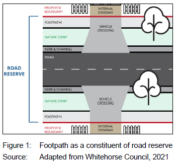
Figure 1 shows a layout of the constituents of a typical road reserve. It shows that a footpath is part of a road reserve. The term 'encroachment', therefore, refers to the process where the adjoining properties intrude into such reserves, consequently affecting the use of designated footpaths as public spaces. This problem occurs due to inadequate development control.
2.2 NMT in public spaces
There is no doubt that sustainable urban transportation promotes a healthy, clean, and high-quality environment and, in so doing, contributes to the objectives of strategic urban development (Yazid et al., 2011: 124; Gudmundsson & Regmi, 2017: 1). However, the agenda can further be actualised by prioritising and investing more in an effective NMT infrastructure (Victoria Transport Policy Institute, 2020: 1; Servaas, 2020: 10). This subsection, therefore, reviews the previous studies on urban transportation planning by paying attention to the pedestrian footpaths as a mode of NMT. The intent is to identify gaps in knowledge on the provision of pedestrian footpaths in urban areas.
Nwakaire et al. (2017: 38) investigated the challenges pedestrians encountered along the Onitsha-Enugu expressway in Nigeria, and established that mainly speeding, aggressive driving, ignorance by pedestrians, intoxication, and poor night visibility caused accidents. They recommended that, when initiating road construction projects, the government should incorporate pedestrian sidewalks and footpaths as part of road reserves. A similar observation was made by Mitullah and Makajuma (2013: 6) in a study on Jogoo Road in Nairobi, Kenya. They established that, although the road had been designed with sidewalks, pedestrians could not effectively make use of them, due to uncontrolled intrusion by cyclists and motorists, thus predisposing them to accidents.
In India, Akanksha, Sharma and Kulkarni (2020: 127) observed that, although NMT resulted in less environmental pollution, it could not fully develop, due to persistent challenges such as encroachment on their infrastructure, poor street design, inadequate institutional framework, and fragmented policies. These findings corroborate that of the World Bank (2019: 16) on the development of NMT in Baku City, Azerbaijan. They established that, although sidewalks were the most critical element of pedestrian infrastructure, they were often poorly constructed or maintained, since the city's executive power had not prioritised investing in urban mobility. In another related study, Das and Goswami (2014: 1) argued that, although every citizen in India had a constitutional right to free movement throughout the country, the right had been violated in the vast majority of cities, as evident from pedestrian infrastructure in urban areas that had been ignored by the planning authorities. In another setting, Mmanake and Vanderschuren (2017: 4799) similarly noted that planning for NMT in South Africa was not considered a priority in the rural areas, due to a limited understanding of its advantages, minimal funding by the government, and competition with other transportation modes.
In Jaipur, India, Sachdeva and Gupta (2020: 779) also evaluated the status of the existing pedestrian facilities, by comparing the observed footpaths with that of the Indian Road Congress (IRC) guidelines on the widths and kerb heights. They found that obstructions such as improper positioning of the storm drainage system, hawking by traders, construction of staircases, and parking affected most of the footpaths. They recommended regular maintenance to ensure that the footpaths remain clean and level, prohibiting the parking of vehicles on them, and ensuring that they conform to the IRC Guidelines. Still in India, Subramanyam and Kumar (2017: 2) established that the lack of pedestrian footpaths in Chennai was mainly caused by rapid urbanisation and inadequate development control. Like Sachdeva and Gupta (2020: 780), they also established that the IRC guidelines were not fully implemented in the design of footpaths. Because of this, they proposed that the planning authority should be more responsive in enforcing the guidelines, constructing additional pedestrian footpaths, and installing more rumble strips. In Kenya, a study by Maigo (2018: 25) along the Nairobi-Mombasa Road, focusing on pedestrian footbridges, established that the facilities were not effectively used, because they had been converted to informal commercial activities. In Nairobi, Angira (2008: 78) comparatively argued that the use of NMT within the Nyamakima area was not sustainable, due to the commercial activities that invaded the footpaths. These challenges occur, due to the absence of NMT sensitisation programmes and encroachment on NMT infrastructure by vehicles. He advised that the use of NMT should be encouraged as a strategy for sustainable urban transportation, since it promotes environmental conservation.
Although the foregoing review reveals that the provision of pedestrian footpaths is infrequently a priority in urban planning, there is hardly any literature on how non-compliance with the planning standard that regulates such footpaths may be spatially and statistically analysed, a gap that this study has filled. The central argument in the current study is that residential neighbourhoods in Kisii town lack adequate footpaths because most of the developers have encroached on the fronting road reserves. Since footpaths are part of road reserves, encroachment on them either reduces the space available for their use by pedestrians or eliminates them, thus attracting a conflict between motorised and NMT modes. This shows the interplay between road reserves and footpaths.
2.3 Public interest theory of regulation
This study was guided by the public interest theory of regulation (PITR) which has two assumptions. First, unregulated economic markets encourage monopoly, a condition that is likely to exploit consumers, and secondly, the state is duty-bound to correct such uncertainties through regulation (Hertog, 2010: 12). PITR, therefore, justifies regulation by the state to protect the public at large rather than to benefit a few individuals (Hantke-Domas, 2003: 165). Because the land is an economic factor of production, the state should regulate its use for road reserves. One of the ways to achieve this is through planning and development control. Related to the current study, the theory justifies why the CGOK should undertake development control to ensure that residential buildings in Kisii town are not encroaching on that part of road reserves that is planned for footpaths. To support this, the Physical and Land Use Planning Act (The Republic of Kenya, 2019a: 639) empowers the CGOK to undertake development control towards promoting orderly development. This certainly includes ensuring that developers do not encroach on the part of road reserves that have been set aside for footpaths.
3. CASE STUDY AREA
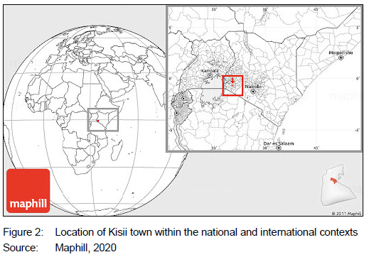
Kisii town is roughly 313km from Nairobi, Kenya's capital city (Figure 2). It is also gazetted as the administrative headquarters of Kisii county.
Kisii town makes an ideal case study because of two central issues. First, according to the Republic of Kenya (2019b: 234), the town's population density of 5 058/km2 rates third in Kenya after Nairobi (6 247/ km2) and Mombasa (5 495/km2), the second-largest city in Kenya. Although Kisii town is, in terms of population size, ranked the 40th largest urban area in Kenya out of the 103 urban centres, its population density markedly surpasses that of the largest towns such as Kisumu (721 082), Nakuru municipality (570 674), Ruiru municipality (490 120), and Eldoret municipality (475 716). Secondly, the town lacks an up-to-date spatial plan, as the existing one was developed in 1972. This demonstrates that the town has been exponentially developing without a policy framework for undertaking development control. A combination of high population density, absence of an up-to-date spatial plan and insufficient development control has intensified land-use change, thus attracting challenges relating to the disregard of the planning standard used in regulating footpaths within residential neighbourhoods. In the event of no planning interventions, the town will further experience unsustainable spatial development that will expose its residents to safety concerns, owing to a conflict between NMT and motorised transport modes.
4. METHODOLOGY
4.1 Research design
In a case study of seven neighbourhoods in Kisii town, Kenya, this study examined whether residential building developments complied with the planning standard of two metres that regulates pedestrian footpaths. As justified by Zainal (2007: 7), case studies are known to permit the investigation and understanding of intricate issues, thus a well-grounded research method when a comprehensive and in-depth inquiry is required. The current study comparatively undertakes an in-depth investigation to determine compliance with the planning standard used in regulating the use of pedestrian footpaths. The study thus adopted a correlational research design, a non-experimental method involving the measurement of two or more variables. According to Curtis, Comiskey and Dempsey (2016: 1), findings from correlational research offer the advantage of determining occurrence and associations between variables, in addition to providing the context for making future predictions based on the collected quantitative data.
Applied to the current study, the collected quantitative data on the observed (measured) widths of footpaths was correlated with that of the recommended planning standard of two metres to determine the extent of compliance. The study also correlated pedestrian footpaths and road reserves to determine whether the two variables had a significant statistical relationship.
4.2 Population and sampling
The target population for this study included individual residential building developments drawn from the seven neighbourhoods of Kisii town, namely Nyanchwa, Jogoo, Egesa, Daraja Mbili, Nyamage, and Nyamataro. Although these formal developments are mainly located on freehold land, they are still subject to development control. A preliminary challenge was the absence of a sampling frame depicting residential buildings, since the CGOK had not established a land information system. To address this gap, a satellite image of 0.31-meter spatial resolution, dated 20 March 2020, was procured from the Regional Centre for Mapping of Resources for Development in Nairobi to help map buildings per residential neighbourhood, thus generating the required sampling frame. The satellite image was integrated with GIS to first delineate the boundary of Kisii town, using the clipping vector function of the QGIS software version 3.16.3 (Hanover). This was followed by the digitisation of all the buildings in the town, followed by a delineation of the boundary of each residential neighbourhood, resulting in a sampling frame. To eliminate overlaps in data collection, the next step involved a two-week ground-truthing/validation exercise to verify that the mapped buildings were all residential and that the boundary of each neighbourhood was accurate. Ultimately, 7 430 residential buildings were successfully mapped, thus providing the required sample frame and study population. The exercise focused on individual residential buildings and not cadastral boundaries. Generally, 1 551,1 105, 1 171,673,808,821, and 1 301 buildings were mapped in Jogoo, Mwembe, Nyamage, Nyanchwa, Nyamataro, Egesa, and Daraja Mbili neighbourhoods, respectively. This was followed by determining the sample size, using a table recommended by Krejcie and Morgan (1970: 608). Acording to this table, if the study population (N) is between 7 000 and 8 000, a sample size (n) of 364 participants should be drawn to participate in the study. To determine the proportional sample size per residential neighbourhood in the study area, the following formula was derived:
MB / TB χ DSS
Where MB = Number of mapped buildings per neighbourhood, TB = Total number of buildings mapped in the study area/ Kisii town (which is 7 430), and DSS = Desired sample size (which is 364 residential buildings).
The above formula resulted in the respective neighbourhood proportional samples of 75 (Jogoo), 54 (Mwembe), 57 (Nyamage), 33 (Nyanchwa), 41 (Nyamataro), 40 (Egesa), and 64 (Daraja Mbili). A random number table, recommended by Saunders, Lewis & Thornhill (2016: 125), was then used to pick samples from each neighbourhood, thus eliminating biases during data collection.
4.3 Data collection
Structured observation checklists, remote sensing, and photography were used in collecting primary data. The checklist consisted of four columns. The first column captured the name of the neighbourhood. The second recorded the recommended planning standard, in this case, two meters as provided for in the Physical planning handbook (The Republic of Kenya, 2007: 25). The third and fourth columns recorded the observed/measured widths of the footpaths and variance, respectively. A positive variance indicated compliance with the planning standard, whereas a negative variance signalled noncompliance. Photographs supported data analysis by visually capturing the problem as directly observed. As alluded to above, a satellite image with a spatial resolution of 0.31 meters, dated 20 June 2020, was used to identify residential buildings. This was complemented by land survey maps that were obtained from the Kisii County Survey Office to indicate the widths of road reserves. The study finally scrutinised various tenders on road construction and maintenance that were awarded by the CGOK in Kisii town during the 2020/2021 financial year to determine whether they had specifications on the provision or maintenance of pedestrian footpaths.
4.4 Data analysis and interpretation
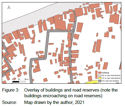
Buildings depicted on the satellite image and road reserves from the survey map were respectively digitised, using QGIS version 3.16.3 (Hanover) software, and thereafter overlayed to determine the extent of compliance (see the illustration in Figure 3). The 'measure' function of the software was then applied to determine whether the sampled residential building encroached on the footpath. To achieve this, if a building completely encroached on the footpath, conformity was immediately assigned as '0' on the checklist. Conversely, in the event of incomplete or partial encroachment, the intrusion was measured, and the outcome was then deducted from the recommended planning standard of two meters to determine the remaining width of the footpath.
The measurements resulting from the GIS spatial analysis were further compared with ground measurements to ensure consistency and accuracy in compliance assessment. After the collected data was entered into the observation checklists, a one-sample t-test (using SPSS version 21) was applied to statistically establish the extent of compliance with the recommended planning standard of two meters that is used in regulating the pedestrian footpaths in the study area. Descriptive statistics (mean and standard deviation) were also employed to further quantify the extent of compliance. In this instance, while the mean was calculated by adding all the measured widths of footpaths within a neighbourhood and then dividing the ensuing arithmetic sum by the number of sampled residential building developments within the same neighbourhood, the standard deviation showed how dispersed the data was in relation to the obtained mean.
Pearson's bivariate correlation was also used to determine whether there was a statistically significant correlation between footpaths and road reserves. The footpaths measured were the result of buildings' encroachment into a road reserve which included a two-metre footpath as part of the road design. The study further used conceptual content analysis to determine whether the 10 tenders awarded on various road works in Kisii town during the 2020/2021 financial year had specifications on the provision or maintenance of pedestrian footpaths. To attain this, the concept of 'footpath' was chosen for examination from each tender document and thereafter quantified by counting its occurrence.
4.5 Reliability and validity
The study employed a test-retest technique through a pilot study in Suneka, a town situated roughly 10km from Kisii town, to determine the reliability of the research instrument. The town was selected because its residential buildings had similar characteristics to those of the study area, especially in housing typologies and the challenge to control developments within the road reserves. To achieve this, 36 developments (10% of the sample size) were targeted for the initial data collection. Data was collected from the developments after two weeks and the results thereafter correlated using Pearson's correlation coefficient.
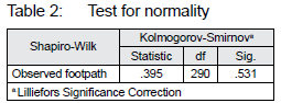
To address external validity, only residential buildings were included in the study, thus assuring that the research findings could be generalised to other urban neighbourhoods that had comparable challenges in the provision of pedestrian footpaths. The study further adopted construct validity to ensure that the test accurately measured what it was intended to measure. In this instance, the checklist had only one construct under investigation, that is, the two metres pedestrian footpath standard recommended by the Physical planning handbook of 2007. The Shapiro-Wilk test was finally used to determine whether the sampled residential building developments were normally distributed in the study area.
5. RESULTS AND DISCUSSION
5.1 Observation survey, tests for reliability and statistical assumption
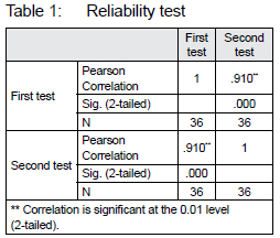
Using the structured observation checklists, data were successfully collected from 290 residential developments (out of a sample size of 364) that were reachable from the seven neighbourhoods, yielding an observation rate of 80%. This exceeded the minimum threshold of 50% as recommended by Mugenda and Mugenda (2003: 89). A reported strong positive Pearson's bivariate correlation coefficient of 0.91 (see Table 1) also confirmed that the checklists were stable, hence reliable for data-collection analysis and drawing a conclusion.
Further to the reliability test, the outcome of the Shapiro-Wilk test (see Table 2) surpassed the threshold of 0.05, confirming that the study population was normally distributed. This also gave credence that the data collected was suitable for analysis as well as for a rational conclusion regarding the research problem.
5.2 Compliance with the planning standard for footpaths
Having ascertained the integrity of the collected data through quality control, this subsection now explores the extent to which residential building developments in Kisii town complied with the planning standard used in regulating the minimum width of pedestrian footpaths. Analysis and discussions are done per residential neighbourhood in the following sequence: Nyanchwa, Jogoo, Egesa, Nyamataro, Daraja Mbili, Mwembe, and Nyamage.
5.2.1 Nyanchwa
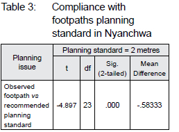
Nyanchwa covers 0.78km2 and is situated in the south-eastern part of Kisii town. It advantageously occupies the slopes of Nyanchwa Hill, giving a picturesque view of Kisii town. An appraisal was, therefore, undertaken to find out if the sampled residential buildings complied with the planning standard used in regulating footpaths on road reserves. Preliminary results showed that the outcome of the measured compliance (M = .4167, SD = .58359) deviated from the appropriate planning standard (two meters) by a difference of 0.583 meters. These observations were further analysed to determine whether they were statistically significant. In Table 3, the results show that the observed measurements significantly deviated from the planning standard (the difference not equal to zero), since t (23) = - 4.897, and p = .000, thus revealing a deficiency in planning control on the part of the CGOK.
Based on the findings presented in Table 3, the study also examined if the widths of road reserves that were fronted by the sampled residential building developments correlated with the corresponding widths of footpaths. Most of the buildings fronted roads that had a 9-meter reserve. This analysis was considered important because, in the design of roads, footpaths are considered one of the constituents of road reserves. The results are compared in Table 4.
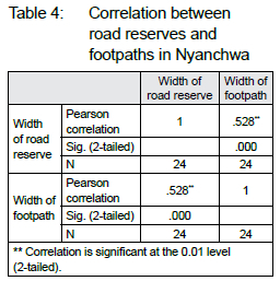
Table 4 shows that there is a positive correlation between the width of road reserves and that of footpaths (r = .528, p = .000), suggesting that if the width of road reserves, as recommended in the Physical planning handbook of 2007, decreases due to uncontrolled encroachment by developers, this significantly contributes to a corresponding decline in the space that would be available for providing footpaths. In this case, the sustainability of footpaths in Nyanchwa largely depends on the extent to which road reserves that contain them are maintained by the CGOK through enforcement and development control. Figure 4 illustrates this interaction.
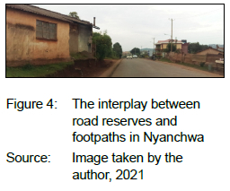
The building in Figure 4 wholly encroached the 9-meter road reserve before part of it was demolished by the CGOK when the road was being upgraded to bitumen standard. The building was, however, not entirely demolished, as part of it dangerously remained on the road reserve, hence still obstructing the space available for the pedestrian footpath. The demolition created a pothole on the footpath that compromises the pedestrians' safety, hence disregarding the development control principles of safety and access. Encroachment on road reserves in Nyanchwa delimits the use of footpaths, a problem also described spatially in Figure 5.
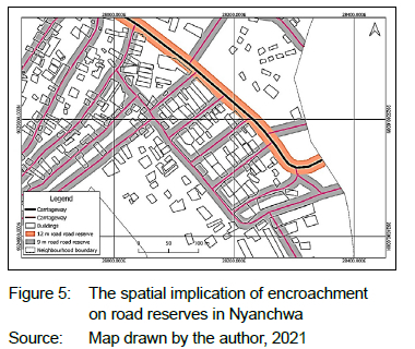
It is further apparent from Figure 5 that, since most of the residential buildings encroached on road reserves, they contributed to the loss of pedestrian footpaths in Nyanchwa, due to inadequate development control and enforcement by the CGOK. Nyanchwa neighbourhood hosts key institutions such as Kisii Primary School, Nyanchwa Adventist Hospital, Getembe Hospital, Nyanchwa Adventist College, Gusii Stadium, and Nyanchwa Police Station. It also emerged as a major commercial centre after the road traversing it was recently upgraded to bitumen standard by the CGOK in an attempt to uplift the neighbourhood's level of transportation. These institutions and commercial establishments attract a high volume of NMT with a particular reference to pedestrians. As such, the lack of footpaths or encroachment on the same repeatedly contributes to land-use conflicts.
5.2.2 Jogoo, Nyamataro, Egesa, and Daraja Mbili
Compliance assessment in the above residential neighbourhoods was undertaken simultaneously because they are situated in the same sublocation. Jogoo is located in the south-eastern part of Kisii town and spatially covers 3km2.
The neighbourhood houses key educational institutions that attract a substantial volume of pedestrian traffic. Some of these institutions include Jogoo Primary School, Sakagwa Primary School, Set Green Hill Academy, Green Valley Academy, and the Kisii National Polytechnic. The neighbourhood is also traversed by the 40-metre Kisii-Nyamira transport corridor that attracts a high volume of motorised and pedestrian traffic. Covering 1.43km2, Egesa, on the other hand, is located in the north-western part of the town along the busy Kisii-Kisumu Road. Nyamataro, which spatially covers 2.1km2, is also situated in the north-western part of the town along the same road. Lastly, Daraja Mbili, in the south-western part of the town, covers 1.9km2. This neighbourhood is among the busiest in Kisii town on account of hosting one of the largest open-air markets (Daraja Mbili) in the western Kenya region. Owing to this status, it attracts traders from as far as Tanzania, thus generating a high volume of pedestrian traffic. This suggests that the provision of adequate footpaths in the neighbourhood needs to be prioritised as a strategy for promoting sustainable urban mobility. This explains why the current study sought to determine whether residential developments in the four neighbourhoods were observing the minimum planning standard that regulates footpaths. The descriptive results are summarised in Table 5.
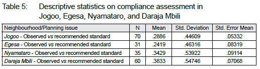
The descriptive statistics in Table 5 show that compliance was low in all neighbourhoods, as reported by their respective means: Jogoo (.2886), Egesa (.2419), Nyamataro (.3429), and Daraja Mbili (.3833), an indication that most of the developments encroached on the spaces reserved for pedestrian footpaths. This undoubtedly disregards the principle of sustainable urban mobility that seeks to enhance and maintain a safe NMT infrastructure and, in so doing, satisfy the mobility requirements of urban residents. Anchored on this background, the study explored whether the observed non-compliance was significant. This was necessary to confirm that the results did not randomly occur in the study population but were rather attributable to insufficient development control (see Table 6).
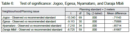
Results in Table 6 draw attention to the fact that the observed non-compliance in Jogoo was statistically significant, t (69) = -13.343, p = .000, as was the case with Egesa, t (30) = -9.113, p = .000; Nyamataro t (34) = -7.210, p = .000, and Daraja Mbili t (59) = -8.725, p = .000. The problem was instigated by laxity on the part of the CGOK to enforce the planning standard. Using a section of Jogoo, the scale of the problem is spatially depicted in Figure 6.
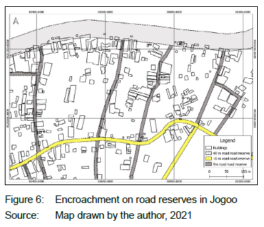
Figure 6 presents a case example that most of the residential buildings in the four neighbourhoods are situated within the road reserves, thus affecting the pedestrian footpaths, because, as mentioned earlier, footpaths are considered part of road reserves. Informed by this background, a further examination was undertaken to statistically explore if there was a correlation between the pedestrian footpaths and the road reserves in the four residential neighbourhoods. Table 7 presents the results in the form of a correlation matrix.
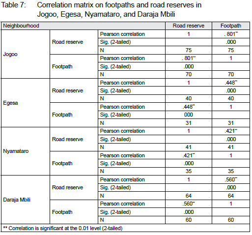
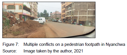
Table 7 yields positive and significant correlations between road reserves and footpaths in Egesa because r =. 801 and p =.000. A relative trend ensued in Egesa, r =. 448, r =.000; Nyamataro, r =. 421, p =.000, and Daraja Mbili, r =. 560, p =.000. It can, therefore, be construed that the four neighbourhoods, as similarly observed in Nyanchwa, are also contending with unregulated encroachment on road reserves, thus affecting footpaths. The problem is illustrated in Figure 7 where residential apartments have extended on the road reserve, thus engulfing the space available for pedestrian footpaths. There is a deliberate disposal of construction waste (sand and bricks) on the footpath, a practice prohibited by the Physical and Land Use Planning Act (The Republic of Kenya, 2019a: 639) that describes 'development' to also include the deposit of such waste on land. Further, the planned upgrade of the Daraja Mbili market by the CGOK to include modern wholesale shops is likely to attract more NMT traffic. Assuming lack of planning intervention, the conflict between NMT and motorised transport is expected to escalate in the four neighbourhoods.
5.2.3 Nyamage and Mwembe
Compliance assessment in the two neighbourhoods was undertaken simultaneously, because the other applicable planning standards such as floor area ratio and minimum plot size are similar. Both neighbourhoods are also situated in the eastern part of Kisii town and share a common boundary. Since the two neighbourhoods are also zoned to accommodate high-density development, they generate a substantial volume of NMT traffic. Apart from this, the neighbourhoods are traversed by the 40-metre Kisii-Kilgoris Road, a major transportation corridor that links Kisii town with Narok county. This corridor is also attracting a high volume of pedestrian traffic. Furthermore, the neighbourhoods are less than 2km from the central business district of Kisii town, thus encouraging walking by those who cannot afford motorised transport. Nyamage is of particular interest, because it hosts Kisii University with a student population of over 20 000. This has created a demand for hostels and recreational facilities, leading to an increased generation of NMT. An initial descriptive analysis showed that the mean conformity with the planning standard of two meters was low in both neighbourhoods (0.1750 m in Mwembe and 0.066 m in Nyamage). The highest standard deviation (0.44650) was recorded in Mwembe compared to 0.25371 in Nyamage. Given this, a further examination was undertaken (see Table 8) to determine the statistical significance.
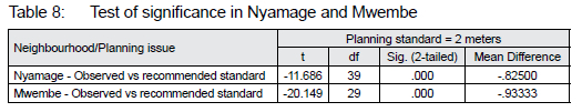
Results in Table 8 show that, in Nyamage, there was a statistically significant difference between the observed pedestrian footpaths and the recommended planning standard, t (39) = -11.686, p = .000. Compliance declined by a mean of .82500. A similar problem arose in Mwembe, where the mean difference of -.93333 was significant, t (29) = -20.149, p = .000. The problems continue unabated notwithstanding the powers granted by the Physical and Land Use Planning Act (The Republic of Kenya, 2019a: 639) to the CGOK to undertake planning and development control. Similar to Jogoo, Egesa, Nyamataro, and Daraja Mbili, analysis was also done in Nyamage and Mwembe to examine if there was a correlation between footpaths and road reserves, because, as alluded to earlier, when it comes to transportation planning, footpaths are normally considered integral elements of road reserves. The other linked elements include but are not limited to stormwater drainage and carriageway. The results are reported in Table 9.
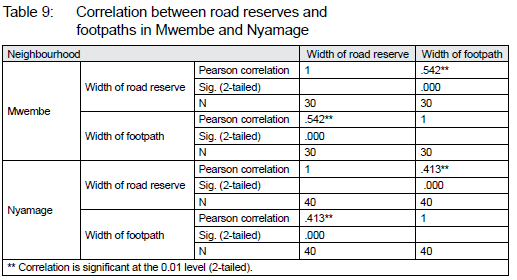
Table 9 confirms that, in Mwembe, a positive correlation resulted between the size of footpaths and the widths of road reserves (r = -.542, p = .000), implying that when the widths of road reserves decrease, as recommended in the Physical planning handbook, a corresponding decline in the size of footpaths is registered. A comparable interplay was observed in Nyamage (r = .413, p =.000), where there was a significant positive correlation between the two variables. In both instances, it is apparent that residential buildings that usually encroach on the road reserves openly affect pedestrian footpaths. The magnitude of this problem is further confirmed in Figure 8.
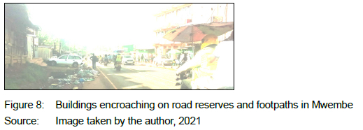
Figure 8 shows a multiplicity of conflicts within the road reserve: most of the residential buildings are encroaching on the road reserves, thus affecting the footpaths; motorists tend to park vehicles across the footpaths, and residents indiscriminately dispose of wastes on the road reserve, due to irregular solid-waste collection. All these challenges combined delimit the provision and use of footpaths. The uncollected wastes noticeably expose pedestrians to public health problems. Finally, as indicated in the methodology section, the current study examined if various tenders on road construction and maintenance that were awarded by the CGOK had specifications on pedestrian footpaths. Results show that none of the ten tenders awarded had considered either to provid new footpaths or to maintain the existing ones. CGOK thus did not prioritise investing in pedestrian footpaths.
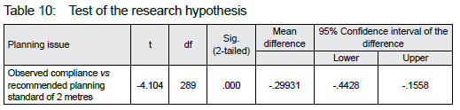
5.3 Research hypothesis
The study had a null hypothesis that there was no significant difference between the planning standard (two metres) used in regulating footpaths and the observed/measured level of compliance by residential buildings in Kisii town. This was tested using a one-sample t-test. As noted in Table 10, the test found a statistically significant difference, t (289) = -4.104, p = .000. Compliance declined by a mean of 0.2993, suggesting insufficient planning and development control by the CGOK.
In the absence of policy interventions, the status quo will continue to contribute to unsustainable spatial development at the expense of the development control principles of safety and access. These findings relate to those of Gyuk et al. (2016: 146) who found that encroachment on the road reserves in Kaduna Metropolis, Nigeria, caused a conflict between pedestrians and vehicular traffic. The findings further corroborate those of Orege (2018: 118), who established that the widths of the pedestrian footpaths in Komarock estate, Nairobi city, did not comply with the standard of two meters, making them unable to accommodate the high pedestrian traffic that was generated during peak hours. The research findings are also in line with those of Omollo (2021: 12; 2020b: 107; 2020a: 11) as well as Omollo and Opiyo (2020: 127) who respectively established that residential building developments in Kisii town, Kenya, did not comply with the planning standards that regulate floor-area ratio, building lines, spaces around domestic buildings, and land subdivisions. The current study, however, examines how compliance with the standards on footpaths may be assessed through a concurrent triangulation of statistical and spatial approaches, a gap that hitherto existed in literature.
6. CONCLUSION AND RECOMMENDATIONS
Residential building developments rarely comply with the planning standard used in regulating footpaths in Kisii town. The problem is exacerbated by developers who encroach on the road reserves, thus restricting the space available for footpaths, and undermining the development control principles of access and safety. The issue remains unresolved, even though the CGOK retains the legal mandate of development control. It was also observed that the scope of planning, design, and maintenance of roads in Kisii town and, by extension, in Kenya is generally limited to improving the carriageway (road), with no attention paid to footpaths that are part of road reserves. The problem is exacerbated by the fact that the CGOK does not prioritise pedestrian footpaths as one of the design criteria when awarding tenders for the construction or maintenance of roads in Kisii town. It is, therefore, recommended that, when constructing new roads or maintaining existing ones, the process of contractual tendering should comprehensively cover all the constituents of a road reserve, including footpaths. To complement this, the CGOK should regularly undertake surveillance audits to ensure strict compliance by developers. This study validated the potency of PITR in building development control. It also demonstrated that compliance with the standards used in regulating footpaths may be appraised through a triangulation of spatial and quantitative analyses. However, since this study was limited to the enforcement of planning standards on footpaths, further research may be undertaken to explore if contiguous developments also comply with stormwater drains, as constituents of road reserves. The reason for this is that the infrastructure plays a critical role in directing excess rainwater, an initiative for extending the durability of roads. In addition, given that the scope of this study was limited to residential building developments, future studies may be conducted to determine whether other categories of developments such as commercial and industrial developments comply with the planning standard.
REFERENCES
AKANKSHA, D., SHARMA, B. & KULKARNI, R. 2020. Enhancing non-motorized transport system of Indian cities. [Online]. Available at: <https://urbanupdate.in/enhancing-non-motorized-transport-system-of-indian-cities/> [Accessed: 11 February 2019]. [ Links ]
ANGIRA, O.C.A. 2008. Challenges and opportunities for sustainable urban mobility (non-motorized transport): A case study of Nyamakima area, Nairobi County, Kenya. Unpublished Master's thesis, University of Nairobi. [Online]. Available at: <http://erepository.uonbi.ac.ke/handle/11295/56520> [Accessed: 15 December 2020]. [ Links ]
BASTO, L. & MORAES, N. 2021. The benefits of non-motorized transport in the city of Rio de Janeiro. 15th International Conference on Urban Regeneration and Sustainability. [Online]. Available at: <https://www.witpress.com/elibrary/wit-transactions-on-ecology-and-the-environment/129/20843> [Accessed: 11 October 2020]. [ Links ]
CARMONA, M. 2018. Principles for public space design, planning to do better. Urban Design International, 24, pp. 47-59. https://doi.org/10.1057/s41289-018-0070-3 [ Links ]
COUNTY GOVERNMENT OF NAIROBI. 2020. Urban streets and road design manual for non-motorized transport. Draft manual. [Online]. Available at: <https://www.kara.or.ke/KARA%20Urban%20Streets%20and%20Road%20Design%20Manual%20for%20NMT.pdf> [Accessed: 17 March 2021]. [ Links ]
CURTIS, E.A., COMISKEY, C. & DEMPSEY, O. 2016. Importance and use of correlational research. Nurse Researcher, 2(6), pp. 20-25. https://doi.org/10.7748/nr.2016.e1382 [ Links ]
DAS, H. & GOSWAMI, S. 2014. Where are the Footpaths? A case for protecting pedestrian rights in India. The city flix. [Online]. Available at: <https://thecityflx.com/blog/where-are-footpaths-case-protecting-pedestrian-rights-india-himadri-das-sahana-goswami/> [Accessed: 21 May 2021]. [ Links ]
DUIVENVOORDEN, E., HARTMANN, T., BRINKHUIJSEN, M. & HESSELMANS, T. 2020. Managing public space - A blind spot of urban planning and design. Cities, 03032. [Online]. Available at: <https://www.sciencedirect.com/science/article/pii/S0264275120313809> [Accessed: 18 April 2022]. https://doi.org/10.1016/j.cities.2020.103032 [ Links ]
FIA FOUNDATION. 2016. Factsheet: Non-motorized transport (NMT). [Online]. Available at: <https://www.flafoundation.org/media/224035/flaf-factsheet-1-non-motorised-transport.pdf> [Accessed: 21 May 2021]. [ Links ]
FILHO, L., AZEITEIRO, U., AZUL, A.M., BRANDLI, L., GÖKCIN ÖZUYAR, P. & WALL, T. (Eds). 2020. Encyclopedia of the UN Sustainable Development Goals, 3(2). Cham, Switzerland: Springer. [Online]. Available at: <https://www.springer.com/gp/book/9783319956749> [Accessed: 6 June 2021]. [ Links ]
GUDMUNDSSON, H. & REGMI, M.B. 2017. Developing the sustainable urban transport index, transport and communications bulletin for Asia and the Pacific, 87. [Online]. Available at: <https://www.unescap.org/sites/default/files/buNetin87_3%20Developing%20the%20Sustainable%20Urban%20Transport%20Index_0.pdf> [Accessed: 12 June 2021]. [ Links ]
GYU, D.B., BAJI, A.J., UBANGARI, Y.A. & BABARINS, D. 2016. Violation of development control provisions by public and semi-public developers along Kachia Road, Kaduna Metropolis. IOSR Journal of Environmental Science, Toxicology and Food Technology, 10(8), pp.146-151. https://doi.org/10.9790/2402-100802146151 [ Links ]
HANTKE-DOMAS, M. 2003. The public interest theory of regulation: Non-existence or misinterpretation? European Journal of Law and Economics, 15, pp.165-194. https://doi.org/10.1023/A:1021814416688 [ Links ]
HERTOG, J. 2010. Review of economic theories of regulation. Discussion paper series No. 10. [Online]. Available at: <https://dspace.library.uu.nl/bitstream/handle/1874/309815/10_18.pdf> [Accessed: 11 May 2021]. [ Links ]
KREJCIE, R.V. & MORGAN. D.W. 1970. Determining sample size for research activities. Educational and Psychological Measurement, 30, pp. 607-610. https://doi.org/10.1177/001316447003000308 [ Links ]
MAIGO, L. 2018. Provision and Utilization of Pedestrian Footbridges in Cities: A case study of Mombasa road corridor, Nairobi. Unpublished master's thesis, University of Nairobi. [Online]. Available at: <http://erepository.uonbi.ac.ke/handle/11295/104017> [Accessed: 23 May 2021]. [ Links ]
MAPHIL. 2020. Gray location map of Kisii Municipality, highlighted grandparent region, within the entire country. [Online]. Available at: <http://www.maphill.com/kenya/nyanza/kisii/kisii-municipality/location-maps/gray-map/highlighted-grandparent-region/entire-country/> [Accessed: 28 May 2021]. [ Links ]
MITULLAH, W. & MAKAJUMA, G. 2013. Analysis of non-motorized travel conditions on the Jogoo Road corridor in Nairobi. [Online]. Available at: <http://erepository.uonbi.ac.ke/handle/11295/61279>. [Accessed: 6 June 2021]. [ Links ]
MMANAKE, M. & VANDERSCHURE, M.M. 2017. The significance of non-motorized transport interventions in South Africa - A rural and local municipality focus. Transportation Research Procedia, 25, pp. 4802-4825. [Online]. Available at: <https://www.sciencedirect.com/science/article/pii/S2352146517307986> [Accessed: 19 April 2021]. [ Links ]
MOHAPATRA, D. 2015. Feasibility of non-motorized transport facilities in Addis Ababa City of Ethiopia: An economic analysis. [Online]. Available at: <http://www.academia.edu/27940801/Feasibility_of_Non_motorized_Transport_Facilities_in_Addis_Ababa_City_of_Ethiopia_An_Economic_Analysis?auto=download> [Accessed: 19 April 2021]. [ Links ]
MUGENDA, O.M. & MUGENDA, A.G. 2003. Research methods, quantitative and qualitative approaches. Nairobi: Act Press. [ Links ]
NWAKAIRE, C.M., CHUKU, D.E. & UDEMBA, J. 2017. The challenges and possible remedies to poor pedestrian safety considerations along and across Nigerian busy roads. MOJ Civil Engineering, 2(1), pp. 36-41. https://doi.org/10.15406/mojce.2017.02.00025 [ Links ]
OMOLLO, W.O. 2020a. Provision of car parking space in the residential neighbourhoods: A development control challenge in urban areas. International Journal of Human Capital in Urban Management, 5(1) pp. 1-18. [ Links ]
OMOLLO, W.O. 2020b. Compliance with the planning standards in regulating building lines. The Case of Kisii Town, Kenya. Journal of Settlements and Spatial Planning, 11(2), pp. 95-111. https://doi.org/10.24193/JSSP.2020.2.04 [ Links ]
OMOLLO, W.O. 2021. Development control on urban road reserves in Kenya: A case study on compliance with planning standards. International Journal of Architecture and Urban Planning, 31(1), pp. 1-15. [ Links ]
OMOLLO, W.O. & OPIYO, R.O. 2020. Appraisal of compliance with land subdivision planning regulations in residential neighbourhoods. International Journal of Human Capital in Urban Management, 5(2), pp. 125-138. [ Links ]
OREGE, M.O. 2018. Evaluation of pedestrian walkways along urban roads: The case of Komarock, Nairobi. Unpublished MSc. Thesis, University of Nairobi. [Online]. Available at: <http://erepository.uonbi.ac.ke/handle/11295/104193> [Accessed: 6 June 2021]. [ Links ]
OTA, H., MATSUDA, Y. & IWATA, K. 2018. A case study on footpaths running through public space in Hokkaido. Urban and Regional Planning Review, vol. 5, pp. 25-42. https://doi.org/10.14398/urpn5.25 [ Links ]
RIETVELD, P. 2001. Working paper biking and walking: The position of non-motorized transport modes in transport systems. Tinbergen Institute Discussion Paper, no. 01-111/3. [Online]. Available at: <https://www.econstor.eu/bitstream/10419/85915/1/01111.pdf> [Accessed: 6 June 2021]. [ Links ]
SACHDEVA, N. & GUPTA, K. 2020. Analysis of existing pedestrian facilities at selected areas of Jaipur City. International Research Journal of Engineering and Technology (IRJET), 7(5), pp 779-782. [ Links ]
SALON, D. & GULYANI, S. 2019. Commuting in urban Kenya: Unpacking travel demand in large and small Kenyan cities. Sustainability, 2(11), article number 3823. https://doi.org/10.3390/su11143823 [ Links ]
SAUNDERS, M., LEWIS, P. & THORNHILL, A. 2016. Research methods for business students. 7th edition. Harlow: Pearson. [ Links ]
SERVAAS, M. 2020. The significance of non-motorized transport for developing countries: Strategies for policy development. [Online]. Available at: <https://www.gtkp.com/assets/uploads/20091124-204932-9999-non_motor_i-ce.pdf> [Accessed: 7 May 2021]. [ Links ]
SIDDHARTHKUMAR, S.L. 2015. NMT approach for planning and re-designing of major intersections of Varachha Road: Surat City Phase - II (740002). Unpublished dissertation, Gujarat Technological University. [Online]. Available at: <https://www.academia.edu/13877209/nmt_approach_for_planning_and_re-designing_of_major_intersections_of_varachha_road_surat_city> [Accessed: 17 May 2021]. [ Links ]
SKAYANNIS, P., GOUDAS, M., CRONE, D., CAVILL, N., KAHLMEIER, S. & MITSIADI, V. 2019. Health-related benefits of non-motorised transport: An application of the health economic assessment tool of the World Health Organization to the case of Trikala, Greece. In: Nathanail, E. & Karakikes, I. (Eds). Data analytics: Paving the way to sustainable urban mobility. CSUM 2018. Advances in Intelligent Systems and Computing, vol. 879, pp. 789-796. Springer, Cham. https://doi.org/10.1007/978-3-030-02305-8_95 [ Links ]
SUBRAMANYAM, R. & KUMAR, P. 2017. Improving pedestrian facilities in congested urban areas: A case study of Chennai City. IOP Conf. Series: Earth and Environmental Science, vol. 80, article number 012059. DOI: 10.1088/1755-1315/80/1/012059 [ Links ]
THE FEDERAL REPUBLIC OF ETHIOPIA. 2020. Ethiopia non-motorized transport strategy 20202029. [Online]. Available at: <https://unhabitat.org/sites/default/flles/2020/07/ethiopia_nmt_strategy_en_200629.pdf> [Accessed: 23 May 2021]. [ Links ]
THE REPUBLIC OF KENYA. 2007. Physical planning handbook. Kenya: Ministry of lands. [ Links ]
THE REPUBLIC OF KENYA. 2012. Sessional paper of 2012 on integrated national transport policy. [Online]. Available at: http://repository.kippra.or.ke/handle/123456789/1282?show=full [Accessed: 23 February 2021]. [ Links ]
THE REPUBLIC OF KENYA. 2019a. Physical and Land Use Planning Act. [Online]. Available at: <http://kenyalaw.org/kl/fileadmin/pdfdownloads/Acts/2019/PhysicalandLandUsePlanningAct_No13of2019.pdf> [Accessed: 21 June 2021]. [ Links ]
THE REPUBLIC OF KENYA. 2019b. Kenya population and housing census: Vol. I: Population by county and sub county. [Online]. Available at: <https://www.knbs.or.ke/?wpdmpro=2019-kenya-population-and-housing-census-volume-i-population-by-county-and-sub-county> [Accessed: 17 June 2021]. [ Links ]
THE WORLD BANK. 2021. Development of non-motorized transportation in Baku City. [Online]. Available at: <http://pubdocs.worldbank.org/en/675751580136093610/Baku-Non-Motorized-Transport-Study-June-2019.pdf> [Accessed: 13 June 2021]. [ Links ]
UNCRD (UNITED NATIONS CENTRE FOR REGIONAL DEVELOPMENT). 2018. Mobility and NMT in sustainable urban development - Role of city developers. [Online]. Available at: <https://www.uncrd.or.jp/content/documents/7048Presentation%201-Mr.%20Singh.pdf> [Accessed: 26 February 2021]. [ Links ]
UNEP (UNITED NATIONS ENVIRONMENT PROGRAMME). 2017. NMT policy development: Lessons learned from the share the road programme. [Online]. Available at: <https://wedocs.unep.org/handle/20.500.11822/22500> [Accessed: 23 June 2021]. [ Links ]
VICTORIA ROAD MANAGEMENT ACT. 2004. [Online]. Available at: <http://www5.austlii.edu.au/au/legis/vic/consol_act/rma2004138/> [Accessed: 11 June 2021]. [ Links ]
VICTORIA TRANSPORT POLICY INSTITUTE. 2020. Economic value of walkability. [Online]. Available at: <https://webcache.googleusercontent.com/search?q=cache:Of47peVpsvsJ:https://www.vtpi.org/nmt-tdm.pdf+&cd=4&hl=en&ct=clnk&gl=ke> [Accessed: 14 May 2021]. [ Links ]
WANG, L. XUE, X., ZHAO, I.Z. & WANG, Z. 2018. The impacts of transportation infrastructure on sustainable development: Emerging trends and challenges. International Journal of Environmental Research and Public Health, 15(6), article number 1172, pp. 1-24. DOI: 10.3390/ijerph15061172 [ Links ]
WHITEHORSE COUNCIL. 2021. Roads, footpaths and vehicle crossings. [Online]. Available at: <https://www.whitehorse.vic.gov.au/roads-footpaths-and-vehicle-crossings> [Accessed: 14 May 2021]. [ Links ]
WORLD BANK. 2019. Development of non-motorized transportation in Baku City. [Online]. Available at: <https://thedocs.worldbank.org/en/doc/675751580136093610-0080022020/original/bakunonmotorizedtransportstudyjune2019.pdf> [Accessed: 14 May 2021]. [ Links ]
YAZID, M.R., ISMAIL, R. & ATIQ, R. 2011. The use of non-motorized for sustainable transportation in Malaysia. Procedia Engineering, vol. 20, pp. 125-134. https://doi.org/10.1016/j.proeng.2011.11.147 [ Links ]
ZAINAL, Z. 2007. Case study as a research method. Jurnal Kemanusiaan, 5(1), pp. 10-15. [ Links ]
Received: June 2021
Peer reviewed and revised: September 2021
Published: June 2022
* The author(s) declared no potential conflicts of interest with respect to the research, authorship, and/or publication of this article

