


Services on Demand
Article
 English (pdf)
 Article in xml format
 Article references
Indicators

Related links
-
 Cited by Google
 -
 Similars in Google
Share

 Permalink
Town and Regional Planning
On-line version ISSN 2415-0495
Print version ISSN 1012-280X
Town reg. plan. (Online) vol.78 Bloemfontein 2021
http://dx.doi.org/10.18820/2415-0495/trp78i1.6
ARTICLES
An explorative approach to the evolving municipal landscape of South Africa: 1993-2020
'N verkennende benadering tot die ontwikkelende administratiewe landskap van Suid-Afrika: 1993-2020
Phuputso ea maemo a fetohang a bo masepala ba Afrika Boroa: 1993-2020
Zaakirah JeevaI; Juanee CilliersII
IDr Zaakirah Iqbal Jeeva, Post-Doctoral Fellow, Unit for Environmental Sciences and Management, North-West University, Potchefstroom, 2520, South Africa. Phone: 0725702956, email: <Zaakirah.jeeva@gmail.com>, ORCID: https://orcid.org/0000-0001-5327-859X
IIProf. Elizelle Juanee Cilliers, Unit for Environmental Sciences and Management, Urban and Regional Planning, North-West University, South Africa. Phone: 018 299 2486, email: <Juanee.Cilliers@nwu.ac.za>, ORCID: https://orcid.org/0000-0002-8581-6302. Faculty of Design, Architecture and Building, University of Technology Sydney, Australia, email: <Juanee.cilliers@uts.edu.au>
ABSTRACT
The establishment of municipalities in South Africa has been a long and difficult process, which still appears to be evolving 25 years later. In 1994, the new democratic government undertook to restructure the country's racially segregated administrative structure, by integrating areas to form cohesive municipal entities that would allow for the more efficient management of the municipal areas. However, the demarcation approach was easier to pen on paper than to implement in practice. This article explores the South African spatial reform process from 1993 to 2020, by analysing literature and legislative frameworks, in order to determine how municipalities were demarcated and the challenges they experienced. The study found that the spatial restructuring process was particularly complex, due to limited knowledge of the spatial landscape and the many unresolved spatial administrative issues. The study calls for further research to support the formation of more efficient municipal areas.
Keywords: Categorisation, demarcation, municipalities, racial integration, spatial reform, South Africa
OPSOMMING
Die stigting van munisipaliteite in Suid-Afrika was 'n lang en moeilike proses en, na 25 jaar, blyk dit om nog in die ontwikkelingsfase te wees. In 1994 het die nuwe demokratiese regering onderneem om die land se rasgeskeide administratiewe struktuur te herstruktureer, deur gebiede te integreer en sodoende samehangende munisipale entiteite te skep wat sou lei tot meer doeltreffende bestuur van streke. Die afbakeningsbenadering was egter makliker om op papier vas te pen, as om dit in die praktyk te implementeer. Hierdie artikel bestudeer die Suid-Afrikaanse ruimtelike hervormingsproses tussen 1993 en 2020 deur middel van 'n literatuurstudie en analise van die wetgewende raamwerke, met die doel om te bepaal hoe munisipaliteite afgebaken was en die uitdagings wat hulle ervaar het. Die studie het bevind dat die ruimtelike herstruktureringsproses besonder ingewikkeld was weens beperkte kennis van die ruimtelike landskap sowel as gepaardgaande onopgeloste ruimtelike administratiewe kwessies. Die studie vra vir verdere navorsing om die vorming van doeltreffender administratiewe streke te ondersteun.
Sleutelwoorde: Afbakening, kategorisering, munisipaliteite, rasse-integrasie, ruimtelike hervorming, Suid-Afrika
SA BONAHALENG
Ho thehoa ha bo masepala Afrika Boroa e bile motjha o motelele hape o boima, o bileng o ntseng o tsoelapele ho fetoha lilemo tse 25 o qalile. Ka 1994, mmuso o motjha wa demokrasi o ile wa itlama ho hlophisa botjha tsamaiso ya naha e nang le kgethollo ya morabe. Sena e se entse ka ho kopanya dibaka ho theha makala a hokahaneng a masepala ele ho bebofatsa tsamaiso e hlophisehileng ea libaka tsa masepala. Le hoja mokhoa oa ho arola moeli o bile bonolo ho reroa le ho ngoloa fats'e, ho bile thata haholo ho o kenya ts'ebetsong. Sengoloa sena se hlahloba ts'ebetso ea ntlafatso ea libaka tsa Afrika Boroa ho tloha ka 1993 ho isa ho 2020, ka ho sekaseka lingoliloeng le meralo ea melao, ho tseba hore na bo masepala ba arotsoe joang le liphephetso tseo ba bileng le tsona ts'ebetsong ena. Phuputso e fumane hore ts'ebetso ea tokiso ea libaka e ne e rarahane 'me ka hona e le thata haholo. Sena se bakiloe ke tsebo e fokolang ea tikoloho 'moho le mathata a mangata a tsamaiso ea libaka a sa kang a rarolloa. Phuputso e eletsa hore lipatlisiso tse ling li etsoe ele ho ts'ehetsa theho ea libaka tsa masepala tse sebetsang hantle.
1. INTRODUCTION
Since the 1970s, urban growth has challenged many governments globally (UNDP, 2016: 1). As a result, many countries have taken a proactive stance in extending their municipal boundaries to include the peri-urban zone of development, to ensure the efficient management of the growth region (Maheshwari, Singh & Thoradeniya, 2016: 1-2). These municipal boundaries usually denote the edge of the urban services provided by the municipality. They have been restructured by national governments in one of two ways. First, enlarging administrative areas by amalgamating smaller, less economically efficient settlements with larger settlements, in order to create an extensive administrative region (UN-Habitat, 2008: 13; Amusa & Mabugu, 2016: 1). Secondly, containing urban development within a smaller area, in order to allow for the more intensive development of the region (UN-Habitat, 2008: 14; Turok, 2014: 13) (see Figure 1).
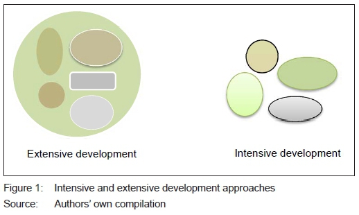
Although both these approaches offer alternate points of view on how municipal boundaries can be structured, there is limited information on what the maximum range should be for the municipality to be developed "extensively" or what the requirements are for settlements to be "intensively" developed, since there is a lack of consensus as to whether "growing-upwards" in the form of compact development is all that is required for a settlement to be successful. Currently, these questions are left open to interpretation and the application differs across countries globally, including Canada, USA, Turkey and Denmark (UNDP, 2016: 2; Maheshwari et al., 2016: 3; Jeeva, 2019).
In the case of South Africa, structural reform is more complex than the mere extension of boundaries to include the peri-urban zone. With the demise of apartheid in the early 1990s, the newly elected democratic government was left with a twofold challenge, namely fragmented human settlements that were segregated into 1 262 small, unequal, racially based administrative regions and the need to accommodate a large influx of inhabitants who were moving into these regions (Turok, 2014: 10; MDB, 2020: 1). The World Bank (2018) reports that, in 1998, approximately 56% of the South African population were already living in urban areas and the number was rapidly rising.
Subsequently, as part of political efforts to end apartheid's spatial administrative planning, a Local Government Negotiating Forum (LGNF) was established in 1992, tasked with amalgamating the racially divided local authorities into a new local government system that would be more economically efficient, inclusive and integrated (Ncube & Monnakgotla, 2016: 76). By 1993, the negotiations at the LGNF resulted in the enactment of the Local Government Transition Act (Act 209 of 1993), which encouraged the spatial restructuring of the country in a racially integrated manner (Cameron & Meligrana, 2010: 5). This was to take place in three distinct phases, namely pre-interim, interim and post-interim (Cameron, 2004: 77; Ncube & Monnakgotla, 2016: 77). This article explores the occurrences in each of these phases in more detail, in order to explore the demarcation and categorisation of municipalities in post-democratic South Africa. The article provides insight into the challenges experienced in the country in terms of its structural reform approach and could provide potential lessons for other countries facing similar challenges.
The study followed a systematic literature review process, in order to analyse, synthesise and evaluate the rationale behind the redetermination of municipalities in South Africa between 1993 and 2021. As part of this method, literature was collected through a range of Google searches, using keywords such as municipal demarcation in South Africa; demarcation; transitional local authorities; municipal service delivery; demarcation process; metropolitan municipalities, and district municipalities. The literature investigation and findings are accordingly presented, in order to understand the rationale behind the redetermination of municipalities and to answer the main research question, namely: "Why do South Africa's municipal boundaries shift so often and what are the implications?"
2. SYSTEMATIC LITERATURE REVIEW
This section comprises the literature review into three distinct phases, namely the pre-interim (1992-1996), the interim (1996-1999) and the post-interim phases (2000-2016), as explained accordingly.
2.1 Pre-interim phase (1993-1996)
In 1993, an interim Constitution (South Africa, 1993a) was introduced to address South Africa in its many dimensions and respond to the findings of the LGNF (South Africa, 1993b). As a result, it legislated the formation of a wall-to-wall administrative structure that would comprise racially integrated municipal entities based on a "one city, one tax base" principle. The first step in its implementation was to dismantle the four previous provinces along with the homelands to form nine racially integrated provinces (Goodenough, 2004: 2-3).
Once these provinces were established, nine provincial commissions were elected to demarcate boundaries of transitional local authorities (TLAs) into any of the three categories, namely urban, rural and metropolitan. These TLAs were demarcated using the 'nearest neighbour principle', with White urban areas and the adjacent townships being merged as one exte sive urban or metropolitan TLA. The neighbouring rural areas were excluded and categorised as separate intensive rural TLAs (Cameron, 2006: 77). This demarcation and categorisation led to the dismantling of the previous 1 262 racial administrations and the creation of 843 TLAs (Cameron, 2004:82). According to Goodenough (2004: 4), even though this demarcation exercise managed to break down the previous apartheid spatial structure to some extent, its boundaries were inconsistent, as they had been demarcated by nine separate provincial demarcation boards, which did not apply a municipal demarcation approach consistently (SALGA, 2016: 13). This resulted in disputes between TLAs regarding whether they qualified for metropolitan status or urban status, and further uncertainty persisted as to whether a small town or a homeland settlement should be classified as an urban TLA or a rural TLA (Cameron, 2006: 78-79; Jeeva, 2019). Consequently, the inconsistent application opened questions as to the political motive behind the extension of local boundaries, which consequently allowed for a larger voting population in the region, i.e. Gerry-meandering (Cameron, 2004: 79).
Irrespective of these concerns, Sutcliffe's (2000: 1) submission acknowledged that the demarcated TLA boundaries during this phase did not recognise the linkages between urban and rural areas. This hindered the integrated and inclusive socio-economic development of regions, which the ANC government was hoping to achieve. As a result, the criteria used for demarcating and categorising municipalities had to be revised to acknowledge the interdependence of all areas in the country (Goodenough, 2004: 6).
2.2 Interim phase (1996-1999)
In order to address the shortcomings of the pre-interim local government reconstruction, Sections 151-155 of the final Constitution (Act 108 of 1996) called for the integration of urban and rural areas within a municipal region (South Africa, 1996). In light of this, it introduced the Category A (metropolitan), Category B (local), and Category C (district) municipal administrative structure (South Africa, 1996). The metropolitan municipalities (Category A) and the district municipalities (Category C) were to be demarcated extensively, while local municipalities (Category B) were to be demarcated more intensively under the management of district municipalities (Goodenough, 2004: 6-7; Van Huyssteen, Meiklejohn, Coetzee, Helga & Oranje, 2010: 29-30). Furthermore, the Constitution called for the appointment of an independent municipal demarcation board (MDB) to take over the demarcation of the country's municipal boundaries together with public participation, in order to avoid inconsistent demarcation practices and minimising Gerry-meandering (Cameron, 2006: 80). Consequently, in 1998, a legislative criterion on how these integrated municipalities should be demarcated was published in Sections 24 and 25 of the Municipal Demarcation Act (Act 27 of 1998) (see Table 1).
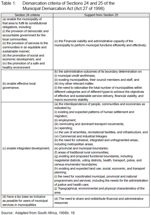
According to Cameron and Melingara (2010: 45-47), Section 24 of this Act contains the requirements that the region should already be fulfilling before the municipal boundary could be demarcated, while Section 25 stipulates the responsibilities that it should be able to fulfil in future.
Accordingly, the above-mentioned legislated criteria can be interpreted as a one-size-fits-all approach, whereby the boundaries of all three administration categories are to be demarcated in the same way and should meet the same requirement.
Upon analysis, Section 24 of the Municipal Demarcation Act (Act 27 of 1998) alludes to the application of a mixture between the functional (A. ii and iii), socio-geographic (A. ii), economies of scale (A. iii), financial viability (D), and the cohesive (C) demarcation approaches as measures that could be used to motivate the delineation of boundaries in South Africa, although it does not explicitly express any policy preference per se. Furthermore, the above-mentioned criterion is rather subjective and complicated and does not provide any clear guidelines on how it should be implemented and measured by the Board or interpreted by the public (Jeeva, 2019).
From an MDB perspective, this was a challenge, since there was already limited knowledge as to the types of human settlements within the country and their respective density and capacity, as data was only collected for some population groups during apartheid (South Africa, 1998a). Hence, it was unclear as to how the demarcated boundary could be measured to ensure that the constitutional obligation was being met within the demarcated region (Jeeva & Cilliers, 2020: 2). Furthermore, there was limited understanding on what made an area urban and what made an area rural and how exactly they should be "integrated" or allow for "effective governance". Until 1997-1998, they were separate administrations (South Africa, 1998a: 20). In addition, municipal boundaries were simultaneously expanding to include underserviced, undeveloped and underdeveloped rural areas and townships, due to rapid mass migration into former White urban areas, making it difficult if not impossible to determine if the region would have a "tax base as inclusive as possible" (SALGA, 2016: 29).
Nevertheless, in 1999, as required by Chapter 7 of the final Constitution, a single independent MDB was established and, according to Section 21 of the Municipal Demarcation Act (Act 27 of 1998), tasked with the responsibility of demarcating both the outer boundaries of these municipalities (Categories A, B, and C) and the internal ward boundaries (South Africa, 1998b: 9). Once this was determined, the MDB was further required to categorise these municipalities according to the Sections 2 and 3 criteria of the Municipal Structures Act (Act 117 of 1998). Subsequently, municipal boundaries were categorised according to the Board's interpretation as follows (SALGA, 2016: 29; South Africa, 1998c) (see Table 2).
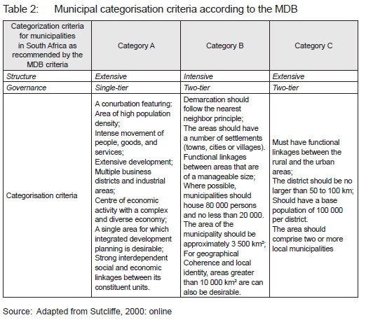
From Table 2, it can be deduced that the criteria for categorising Category A municipalities is a duplication of Section 2 of the Municipal Structures Act (Act 117 of 1998). However, the Board provided implementation criteria on what a Category B and a Category C municipality should comprise and how their boundaries would be demarcated. It was hoped that the objectification of the
Section 3 criteria would allow for transparency and measurability of its application. However, the Board's interpretation of the demarcation criteria also alludes to a mix bag of demarcation approaches, including nearest neighbourhood, functional linkages and coherence, without providing a clear preference of either. Furthermore, the MDB criteria state that Category B municipalities should be of a manageable size. It does not state what that should be or how this could be measured, thus leaving the interpretation open to perception and public interpretation of what an intensive or extensive region should comprise in South Africa (Jeeva, 2019).
Regardless of the ambiguity, in 2000, the Board published maps indicating where it believed district and metropolitan areas should be established and the first of the Section 26 notices were published, showing the boundaries intended (MDB, 1999: 2; SALGA, 2016: 30). By 2001, the outer boundary delimitation process was completed with the demarcation of 284 municipalities. However, the enormity of the work needed and the tight time frame meant an intense work programme, an extensive use of both external and internal resources, and rapid decision-making (Goodenough, 2004: 14-21). Consequently, Cameron (2006: 85-86) reports that many of the consultants did not understand the criteria set out in Section 24 of the Municipal Demarcation Act and many demarcated boundaries were not viable (Sutcliffe, 2000: online). However, in order to accommodate this, the Constitution was amended and other legislation enacted to provide for the demarcation and establishment of cross-boundary municipalities, i.e. municipalities straddling provincial boundaries. As a result, 16 cross-boundary municipalities were established, affecting Ave provinces (Williemse, 2006: 1). According to COGTA (2017: 1), the creation of such municipalities was necessary, in order to bring interdependent people and economies on different sides of a provincial boundary together in one municipality.
In terms of categorising the 300 demarcated municipalities, only 284 were established as municipalities, of which six were categorised as Category A metropolitan municipalities, 231 as Category B local municipalities, and 47 as Category C district municipalities (Goodenough, 2004: 21-22; MDB, 2016: 1) (see Table 3).
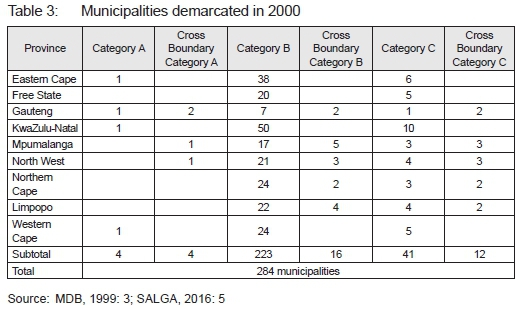
Consequently, on 5 December 2000, the MECs published Section 12 notices, stating that these municipalities and their boundaries were established and that they could not be changed without formal application (SALGA, 2016: 31). This marked the end of the interim phase.
2.3 Post-interim phase (2000-2020)
The post-interim phase represented the final phase of spatial restructuring and was meant to establish all the municipalities demarcated in the previous phase. Accordingly, government published the Municipal Systems Act (Act 32 of 2000) to provide guidelines on how the newly formed integrated municipalities should operate on an administrative level and how they should be spatially planned (De Visser & Poswa, 2019: 7).
However, municipalities were struggling with basic problems of establishment, since it was challenging to provide basic services to a population that was in constant flux. In addition, the implementation of the cross-boundary municipalities presented a number of operational challenges, as there was uncertainty as to who was responsible for what, resulting in underperformance and, in some instances, duplication of services (SALGA, 2016: 32). Furthermore, there was limited understanding on how the region should be planned for in an integrated manner, since there was inadequate national spatial policy that provided direction, and urban and rural areas were still being treated as separate entities, even though they were consolidated (South Africa, 1997; 2001). As a result, by 2002, financial viability became a demarcation issue after the Presidential Coordinating Council (PCC) realised how costly this can be to a municipality (Khumelo & Ncube, 2016: 4).
Consequently, in 2004, a comprehensive review of the first term of local government revealed that the final phase of the transition had been too ambitious and pointed to the worrying mismatch between national policy objectives and local government's capacity to implement them (DPLG, 2006: 1). In response, the Cabinet adopted the Five-Year Strategic Agenda (5YSA) (20062011) as the guiding strategic framework for municipal development and provided a platform to restructure the cross-boundary municipalities (Powell, 2012: 19). As a result, in late 2005, government decided to pass the Cross-Boundary Municipalities Laws Repeal and Related Matters Act (Act 23 of 2005), in order to revoke all legislation pertaining to cross-boundary municipalities, and to realign municipal boundaries with provincial boundaries, by defining the geographic areas of provinces in the Constitution (Willemse, 2006: 1).
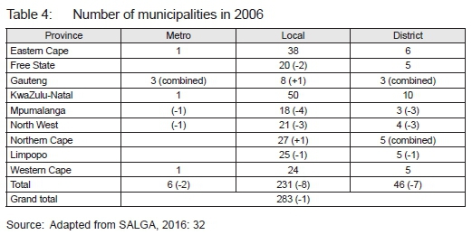
Accordingly, in 2006, a reconfiguration of municipal boundaries resulted in the disappearance of cross-boundary municipalities and a decrease of only one of the district municipalities (SALGA, 2016: 21) (see Table 4).
However, the merging of the 16 cross-boundary municipalities with the already established municipalities meant that, although on paper South Africa had the same number of municipalities as in 2000, these municipalities were much larger than they were previously (Steytler, 2005: 3-5). Some of these areas included Moutse (from Limpopo into Mpumalanga), Matatiele (from Eastern Cape into KwaZulu-Natal), Ba-Ga-Mothibi (from North West into Northern Cape), Balfour (from Mpumalanga into Gauteng), and Kromkuil (from North West into Gauteng).
Amid the cross-boundary challenges, other pressures also began to emerge between 2006 and 2008, including the matter of defining the roles and responsibilities between large Category B municipalities and the related Category C district municipalities (Oranje, 2010: 60). In response to the internal conflict between these entities, the national government contemplated the need for additional independent Category A metropolitan municipalities and, in 2008, the MDB began its assessments of the next largest municipalities in respect of Section 2 of the Municipal Structures Act (MDB, 2008: 2; South Africa, 1998c). As a result, in 2008, the Buffalo City and Mangaung local municipalities (Category B) were introduced as metropolitan municipalities (Category A) (MDB, 2008: 5). During this period, the MDB also found that district municipalities with only two local municipalities did not demonstrate enough critical mass or economies of scale (SALGA, 2016: 33). Subsequently, they took the policy decision to increase the number of local municipalities contained within a district municipality area to three or more rather than the constitutional requirement of only two (SALGA, 2016: 32).
This decision to further amalgamate municipalities was made despite the fact that, in the same political term, many of the municipalities were already found to be in distress and struggling with huge service delivery backlogs, political interference, corruption, fraud, bad management, and lack of public participation (COGTA, 2009: 13). These had already resulted in public discontent that manifested in an increase in violent service-delivery protest across the country (COGTA, 2009: 14). Accordingly, it was brought into question whether the municipalities were not already too large to administer efficiently (Lancaster, 2018: 33).
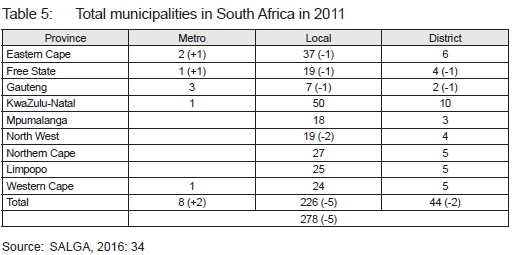
Regardless of this acknowledgement and the rise of service-delivery protest, by the 2011 local government elections, the country had further reduced its municipalities by Ave (from 231 to 226); the 47 district municipalities established in 2000 had been reduced to 44, and two additional metropolitan areas were introduced, namely Mangaung metropolitan municipality and the Buffalo City metropolitan municipality (SALGA, 2016: 33-34; MDB, 2016: 1; Moodley, 2016: 1) (see Table 5).
The reduction in municipalities meant that there were fewer but larger municipalities to administer, with Tshwane becoming the municipality with the largest land area in Africa and the third largest in the world, after New York and Tokyo/Yokohama (City of Tshwane Metropolitan Municipality, 2020: 3). Although these mergers went ahead to form more extensive regions, they had encountered heated resistance by opposition political parties who viewed these as a Gerry-meandering tool to help the ruling party retain power (Mohlahlana, 2016: 1).
Subsequently, in late 2011, the National Planning Commission's National Development Plan: Vision 2030 (NDP) was published to address a number of issues on the country's development, including addressing the ambiguity concerning the roles and responsibilities between the various tiers of local government; guiding investments, and directing the country's development at the macro scale into areas in which it still needed to take place (South Africa, 2012). However, no formal guidance was provided in terms of the number of adequate municipalities, nor their ideal location. As a result, in 2016, COGTA found that approximately one-third of all municipalities were not tax sustainable, economically viable or self-sufficient, since their dependence on inter-governmental transfers was rather high (COGTA, 2016). Subsequently, the department launched the back-to-basics programme, with the aim of improving the functioning of established municipalities to serve communities better. In light of this, COGTA further proposed the strengthening of district municipalities, by amalgamating some intensively developed local municipalities to form more extensive local municipalities (Mubima, 2016: 50; Ngube & Monnakgotla, 2016: 85). Consequently, in 2015, the Minister requested the MDB, in terms of Section 22(2) of the Municipal Demarcation Act to re-determine the boundaries of various municipalities.
After consultation with the MECs for local government, 34 requests were made to the MDB by the Minister and a total of 90 municipalities were affected (Sigdi, 2016: 6). The MDB confirmed the following configuration in 2016 (see Table 6).
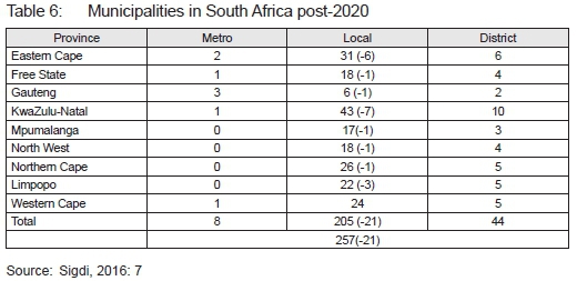
After the 2016 local government elections, eight metropolitan municipalities and 44 district municipalities remained, and the 227 local municipalities of 2011 had been reduced to 205 local municipalities, reducing the total number of municipalities by 21, from 278 to 257 (Sigdi, 2016: 7; Moodley, 2016: 1; Van Rooyen, 2016: 1). According to the then chairperson of the MDB, Ms Jane Thupana, the reduction in municipalities was motivated by Sections 24 and 25 of the Municipal Demarcation Act (Act 27 of 1998) to make the governance of municipalities not only more sustainable, but also financially viable (Moodley, 2016: 1; Thupana, 2015: 1; Sigdi, 2016: 5). However, the idea of amalgamating local municipalities, which were already under distress to correct dysfunctionality and improve financial viability, raised a number of questions. Will the merging of municipalities under distress create financially viable or self-reliant municipalities? Can amalgamation solve functionality challenges? (Ngube & Monnakgotla, 2016: 90-91). Is the same demarcation criterion as prescribed by Section 24 of the Municipal Demarcation Act (Act 27 of 1998) still applicable?
3. INTERPRETATION OF LITERATURE AND EMPIRICAL INVESTIGATION
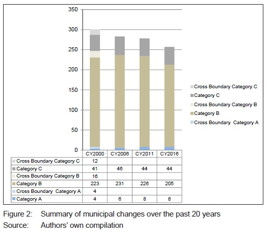
Spatial reform in South Africa has been riddled with complexity. From 1993 (1 262 administrative regions) to 2020 (257 municipalities), the country has experienced a reduction of 1 005 municipal administrative areas that were labelled, defined and demarcated in numerous ways.
Prior to democracy, the administrative regions of the country were intensively developed, based on the racial profile of the community. However, with democracy and the national drive to racially and functionally integrate the country, the final Constitution called for the formation of three administrative entities, namely Categories A, B and C. Category A (metropolitan municipalities) and Category C (district municipalities) were to be planned extensively, while Category B municipalities were to be planned and demarcated intensively. The criteria, whereby these were to be demarcated, were rather complex and politically based standard criteria (see Table 1). As a result, in 1999, the newly appointed MDB proposed objective criteria, whereby all three of these regions should be demarcated based on the requirements of Sections 24 and 25 of the Municipal Demarcation Act (Act 27 of 1998). These regions would then be categorised based on the Board's interpretation of Sections 2 and 3 of the Municipal Structures Act (Act 117 of 1998) (see Table 2). However, the implementation of the criteria was not as easy as initially anticipated, since there is hardly any theory to guide the demarcation of regions. Furthermore, the South African context was still racially segregated, and the Constitution required public consultation before implementation. These factors together challenged the objective implementation of the criteria and led to the formation of cross-boundary municipalities in 2000.
Consequently, it was not practical to manage these municipalities and, in 2006, the municipal boundaries were readjusted to align with provincial boundaries. However, less than two years later, the local municipalities approached the MDB to address the conflict of function and power between the intensively demarcated Category B local municipalities and the related extensively developed Category C district municipalities, which acted as an umbrella body over them. As a solution to reduce the political and administrative conflict, the MDB investigated the adherence of the larger Category B local municipalities to the Section 2 criterion, in order to categorise them as Category A (metropolitan) municipalities. These adjustments were publicly questioned by the opposition parties in 2011, who accused the ruling party of Gerry-meandering, since it was found that many of the district and local municipalities were already under administrative and financial distress. Furthermore, it was uncertain how the new boundaries around the newly formed metropolitan municipalities adhered to the criterion of the Municipal Demarcation Act (see Table 1).
Heedless of these accusations, the MDB re-determined local administrative boundaries in 2011 to reduce conflict between some municipalities and to promote economics of scale in other regions. Both these motivations are not legislated in the Municipal Demarcation Act. As a result, in 2016, it was also found that many of the previously demarcated municipalities were not financially viable. Subsequently, COGTA (2017: 1; Mubima, 2016: 50) called for the additional amalgamation of local municipalities to create more "financially viable" municipalities. This, in turn, led to a supplementary reduction of 26 municipalities over the 14-year period (2006-2020) (see Figure 2).
According to the former chairperson of the MDB, Ms. Jane Thupane (2015), the motivation for this reduction was based on the application of Sections 24 and 25 of the Municipal Demarcation Act (Act 27 of 1998) (see Table 1). However, the article revealed that the motivation for the redetermination of local boundaries differed over the 22-year time period, although the legislation had not changed (see Table 7).
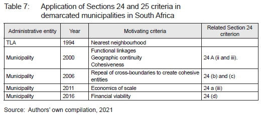
This brings into question the application of the legislation (see Table 1). The literature review revealed that the initial objective of the spatial reform exercise in 1998 was to create a more integrated and cohesive society. Hence, the legislation guiding the demarcation and categorisation criteria was interpreted by the MDB to create municipal regions that offer geographic continuity and social cohesiveness based on the functional linkages observed in the region (see Section 24 (a)(ii, iii) and (d)). However, since 2011, the motivation for the re-demarcation of regions shifted its focus on the formation of regions that offer "economics of scale", which could have been motivated through Section 24 (a)(iii), and the 2016 boundaries were shifted to ensure "financial viability" (see Section 24 (d)). This demonstrates that Section 24 of the Municipal Demarcation Act (Act 117 of 1998) is complex, complicated and tedious to implement. It can thus be easily manipulated. Furthermore, it also illustrates that the implementation does not ensure that all the points listed in the Act are adhered to simultaneously. Only a few points are emphasised according to need.
Upon further research, Global Insight Data (2016) revealed that the average population of the 205 Category B municipalities was 169 366 inhabitants in 2015, while the population of the 44 Category C municipalities was an average of 1 245 132 in the same year. These figures are much higher than what the MDB had initially anticipated in 2000, as illustrated in Table 2 of this article (Cameron, 2004: 93-95). Subsequently, municipalities have complained that their areas are too sparsely populated to tap into the economies of scale or to allow for public participation or effective governance, or the efficient and equitable delivery of services (Khumelo & Ncube, 2016: 11). As a result, 128 of the 243 local administrations are overburdened administratively and are currently considered to be financially nonviable (Omarjee, 2018: 1). In 2020, the Auditor General's report concurred with these findings, and highlighted that the financial situation of municipalities had deteriorated further in two years (2018-2020) (Makwetu, 2020). It was thus questioned whether the Municipal Demarcation Act is implemented correctly and, if so, are larger extensively developed municipalities more sustainable and financially viable than intensively developed regions, or is the Act being manipulated to achieve certain political objectives?
Lastly, the MDB has the power to revise municipal and ward boundaries every Ave years, based on the request from either the Minister, the MDB, or the MEC. These are all political figures, and the Act states hardly anything on how the level of economic growth, spatial development and financial performance of the region could influence boundary re-determined. This could perhaps be considered instead.
4. FINDINGS
The study found that structural reform in South Africa has been rather complex, with the national Constitution opting for both extensive and intensive forms of administrative development in its spatial landscape. However, the criterion guiding the formation of both the extensively and intensively developed municipalities is similar. This makes it easy to manipulate, in order to reach particular social, economic or political objectives. Although the MDB of South Africa had attempted to quantify the manner in which extensive administrative areas should be demarcated and how intensive administrative regions should be categorised, it has had limited success, since the spatial landscape was not developed in an equal manner and many different forces, including the public, local politicians, national government and the constitutional legislation, all influence the demarcation of boundaries (Cameron & Melingara, 2010; Jeeva, 2019).
Initially, boundaries during the pre-interim phase (1993-1996) were demarcated, based on the socio-demographic integration principle. In the interim phase (1996-2000), boundaries were demarcated to allow for integrated development, based on the functional linkages between urban and rural areas. However, in the post-interim period, numerous reasons have been provided for the adjustments of boundaries. In 2005, boundaries were adjusted to overcome cross-boundary municipalities; in 2011, boundaries were again re-determined to avoid municipal conflict and to allow for economics of scale, and, in 2016, boundaries were again revised to facilitate financial viability within municipalities. However, the varying nature of these motivations has brought into question whether local boundaries in South Africa are truly tools that are used to ensure the integrated socio-economic development of the country or whether they are simply political tools being used to capture more votes. This calls for further research into the structural reform of boundaries at the dawn of yet another local election in 2021.
The spatial administrative demarcation of municipalities has experienced dramatic changes over the past 30 years, due mainly to technological developments, freedom of movement and the need to be more financially efficient. The article has shown the complexity of demarcating municipalities in South Africa. It is, however, important to note that this is not an isolated case. Municipalities globally have become more fluid and dynamic and legislation guiding their formation needs to acknowledge this (Fekele, 2018: 127-128).
In the 1960s, demarcation was based on two primary criteria: functional linkages and the goods and services on offer (Christaller, 1966). However, during the recent COVID-19 lockdown, it has become more standard practice to order goods online and work from home. This, in turn, has influenced the location of higher order goods and services and the prominence of functional linkages between settlements (Zandi, 2021). Hence, it is an interesting time to reflect on how these changes will influence the demarcation of spatial administrative regions globally in the near future.
REFERENCES
AMUSA, H. & MABUGU, R. 2016. The contribution of fiscal decentralization to regional inequality: Empirical results for South African municipalities. ERSA Working Paper No. 597, pp. 1-41. [ Links ]
CAMERON, R.G. 2004. Local government reorganization in South Africa. In: Meligrana, J. (Ed.). Redrawing local government boundaries: An international study of politics, procedure and decisions. Vancouver: UBC, pp. 87-118. [ Links ]
CAMERON, R.G. 2006. Local government boundary reorganization. In: Pillay, U., Tomlinson, R. & Du Toit, J. (Eds). Democracy and delivery: Urban policy in South Africa. Pretoria: HSRC Press, pp. 76-105. [ Links ]
CAMERON, R.G & MELIGRANA, J. 2010. Criteria for determining municipal boundaries and categorisation of metropolitan municipalities. MDB (Bid No. A03/2010). Pretoria: MDB Publication. [ Links ]
CHRISTALLER, W. 1966. Central places in Southern Germany, The Pioneer Work in Theoretical Economic Geography. Englewood Cliffs, N.J.: Prentice-Hall. [ Links ]
CITY OF TSHWANE METROPOLITAN MUNICIPALITY. 2020. About the City of Tshwane. [Online]. Available at: <http://www.tshwane.gov.za/sites/areyeng/AboutUs/Pages/AbouttheCity.aspx> [Accessed: 29 January 2020]. [ Links ]
COGTA (DEPARTMENT OF COOPERATIVE GOVERNANCE AND TRADITIONAL AFFAIRS). 2009. Local government turn-around strategy. [Online]. Available at: <https://www.gov.za/sites/default/files/gcis_document/201409/locgovt-turnaround-strategy-25-november-2009.pdf> [Accessed: 29 January 2020]. [ Links ]
COGTA (DEPARTMENT OF COOPERATIVE GOVERNANCE AND TRADITIONAL AFFAIRS). 2016. Back to basics - Serving our communities better! [Online]. Available at: <https://www.cogta.gov.za/cgta_2016/wp-content/uploads/2016/06/The-Back-to-Basics-Approach-Concept-Document.pdf> [Accessed: 29 January 2020]. [ Links ]
COGTA (DEPARTMENT OF COOPERATIVE GOVERNANCE AND TRADITIONAL AFFAIRS). 2017. Cooperative governance on cross-boundary municipalities. [Online]. Available at: <https://www.gov.za/speeches/cooperative-governance-cross-boundary-municipalities-21-aug-2017-0000> [Accessed: 29 January 2020]. [ Links ]
DE VISSER, J. & POSWA, X.S. 2019. Municipal law making under SPLUMA: A survey of fifteen "first generation" municipal planning by-laws. Potchefstroom Electronic Law Journal (PER/PELJ) (22), pp. 1-28. http://dx.doi.org/10.17159/1727-3781/2019/v22i0a4658 [ Links ]
DPLG (DEPARTMENT OF PROVINCIAL AND LOCAL GOVERNMENT). 2006. Implementation plan for the five-year local government strategic agenda 20062011. [Online]. Available at: <https://static.pmg.org.za/docs/2006/060906dplg1.pdf> [Accessed: 13 May 2021]. [ Links ]
FEKELE, A.T. 2018. The dilemma of determining urban administrative boundary for land administration: The case of Shire Inda Silase. International Journal of Social Sciences Perspectives, 2(2), pp. 126-160. DOI: 10.33094/7.2017.2018.22.126.160 [ Links ]
GLOBAL INSIGHT DATA. 2016. Population per municipality expressed as a percentage in 2011. [Online]. Available at: <https://ihsmarkit.com/products/global-economic-data.html> [Accessed: 6 June 2016]. [ Links ]
GOODENOUGH, C. 2004. The first decade of the Municipal Demarcation Board: Some reflections on demarcating local government in South Africa. Arcadia: Municipal Demarcation Board. [ Links ]
JEEVA, Z.I. 2019. Reflecting on the formation of metropolitan regions in South Africa. PhD dissertation. NorthWest University, South Africa. [ Links ]
JEEVA, Z.I. & CILLIERS, E.J. 2020. Exploring settlement typologies in post-apartheid South Africa. International Journal of Public Affairs, e-publication, article number e2510. https://doi.org/10.1002/pa.2510 [ Links ]
KHUMELO, B. & NCUBE, M. 2016. Financial and functional viability and sustainability of municipalities: Beyond the demarcation instrument. Paper presented at the MDB Conference on Demarcation and Spatial Transformation. Financial and Fiscal Commission, Pretoria, 23 June. [ Links ]
LANCASTER, L. 2018. Unpacking discontent: Where and why protest happens in South Africa. South African Crime Quarterly, 64, pp. 29-43. https://doi.org/10.17159/2413-3108/2018/v0n64a3031 [ Links ]
MAHESHWARI, B., SINGH, V.P. & THORADENIYA, B. 2016. Balanced urban development: Options and strategies for liveable cities. Springer Nature, Switzerland: Springer International Publishing. https://doi.org/10.1007/978-3-319-28112-4 [ Links ]
MAKWETU, K. 2020. Not too much to go around, yet not the right hands at the till. [Online]. Available at: <https://www.agsa.co.za/Portals/0/Reports/MFMA/201819/GR/MFMA%20GR%202018-19%20Interactive.pdf> [Accessed: 15 April 2021]. [ Links ]
MDB (MUNICIPAL DEMARCATION BOARD). 1999. The determination of metropolitan and district council boundaries. [Online]. Available at: <http://www.demarcation.org.za/site/wpcontent/uploads/2016/12/CH20010410ChairpersonReportMINMEC.pdf> [Accessed: 6 April 2017]. [ Links ]
MDB (MUNICIPAL DEMARCATION BOARD). 2000. Justification reports. Pretoria: Municipal Demarcation Board. [ Links ]
MDB (MUNICIPAL DEMARCATION BOARD). 2008. Investigating into possible demarcation of more metropolitan authorities and the extension of the municipal areas of existing metropolitan areas. Unpublished document. [ Links ]
MDB (MUNICIPAL DEMARCATION BOARD). 2016. Background to municipal boundaries. [Online]. Available at: <http://www.demarcation.org.za/index.php/municipal-boundaries/> [Accessed: 25 December 2015]. [ Links ]
MDB (MUNICIPAL DEMARCATION BOARD). 2020. About demarcation. [Online]. Available at: <http://www.demarcation.org.za/index.php/about-demarcation/> [Accessed: 2 March 2021]. [ Links ]
MOHLAHLANA, C. 2016. The cost of municipal mergers. eNCA, 1 June. [Online]. Available at: <https://www.enca.com/south-africa/elections-roadshow-the-cost-of-municipal-mergers> [Accessed: 15 February 2017]. [ Links ]
MOODLEY, R. 2016. SA local municipalities reduced. [Online].Available at: <https://www.sanews.gov.za/south-africa/sa-local-municipalities-reduced> [Accessed: 6 April 2017]. [ Links ]
MUBIMA, A. 2016. Back to basics: Municipal law. Without Prejudice, 16(4), pp. 47-50. [ Links ]
NCUBE, M. & MONNAKGOTLA, J. 2016. Amalgamation of South Africa's rural municipalities: Is it a good idea? Commonwealth Journal of Local Governance, vol. 19, pp. 75-95. DOI: https://doi.org/10.5130/cjlg.v0i19.5487 [ Links ]
OMARJEE, L. 2018. 17 district municipalities in "financial distress". [Online]. Available at: <www.fin24/economy/17-district-muncipalities-in-financial-distress-treasury-20180522.co.za> [Accessed: 3 June 2018]. [ Links ]
ORANJE, M. 2010. Post-apartheid national spatial development planning in South Africa: A brief history. European Spatial Research and Policy, 17(2), pp. 55-70. https://doi.org/10.2478/s10105-010-0010-8 [ Links ]
POWELL, D. 2012. Imperfect transition -Local government reform in South Africa, 1994-2012. In: Booysen, S. (Ed.). Local elections in South Africa: Parties, people, politics. Bloemfontein: Sun Press. [ Links ]
SALGA. 2016. 15 years of developmental and democratic local government. [Online]. Available at: <https://www.salga.org.za/Documents/Knowledge%20Hub/Local%20Government%20Briefs/15-YEARS-OF-DEVELOPMENTAL-AND-DEMOCRATIC-LOCAL-GOVERNMENT.pdf> [Accessed: 1 February 2020]. [ Links ]
SIGDI, M. 2016. SALGA municipal manager's forum municipal transitional processes. [Online]. Available at: <https://www.salga.org.za/Documents/NMMF%202016/Muthoto%20Sigidi%20-%20Cogta.pdf> [Accessed: 1 February 2020]. [ Links ]
SOUTH AFRICA. 1993a. Interim Constitution of the Republic of South Africa. [Online]. Available at: < https://www.gov.za/documents/constitution/constitution-republic-south-africa-act-200-1993> [Accessed: 6 February 2016]. [ Links ]
SOUTH AFRICA. 1993b. Local Government Transition Act, Act 209 of 1993. Cape Town: Government Printer. [ Links ]
SOUTH AFRICA. 1996. The Constitution of the Republic of South Africa, Act 108 of 1996. Cape Town: Government Printer. [ Links ]
SOUTH AFRICA. 1997. Rural development Framework. [Online]. Available at: <https://www.ecsecc.org/documentrepository/informationcentre/rural-development-framework-document_72333.pdf> [Accessed: 13 May 2021]. [ Links ]
SOUTH AFRICA. 1998a. White Paper on Local Government. Cape Town: Government Printer. [ Links ]
SOUTH AFRICA. 1998b. Local Government: Municipal Demarcation Act, Act 27 of 1998. Cape Town: Government Printer. [ Links ]
SOUTH AFRICA. 1998c. Local Government: Municipal Structures Act, Act 117 of 1998. Cape Town: Government Printer. [ Links ]
SOUTH AFRICA. 2001. The Integrated Rural Development Strategy (ISRDS). [Online]. Available at: <https://www.gov.za/sites/default/flles/gcis_document/201409/isrds0.pdf> [Accessed: 13 May 2021]. [ Links ]
SOUTH AFRICA. 2012. National development plan: A vision for 2030. Cape Town: Government Printer. [ Links ]
STEYTLER, N. 2005. Cross-boundary municipalities to disappear: New provincial borders. [Online]. Available at: <https://dullahomarinstitute.org.za/multilevel-govt/local-government-bulletin/volume-7-issue-4-september-2005/vol-7-no-4-cross-boundary-municipalities-to-dissapear-new-provincial-borders.pdf> [Accessed: 15 June 2010]. [ Links ]
SUTCLIFFE, M. 2000. Report on the activities of the Municipal Demarcation Board. [Online]. Available at: <https://static.pmg.org.za/docs/2000/appendices/000317appendix3.htm> [Date of access: 15 June 2010]. [ Links ]
THUPANE, J. 2015. SA municipal boundaries changed ahead of 2016 elections. [Online]. Available at: <https://businesstech.co.za/news/government/97069/sa-municipal-boundaries-changed-ahead-of-2016-elections/> [Accessed: 5 July 2018]. [ Links ]
TUROK, I. 2014. South Africa's tortured urbanisation and the complications of reconstruction. In: Martine, G. & McGranahan, G. (Eds). Urban growth in emerging economies: Lessons from the BRICS. London: Routledge, pp. 143-190. [ Links ]
UNDP (UNITED NATIONS DEVELOPMENT PLAN). 2016. Sustainable urbanization strategy. UNDP's support to sustainable, inclusive and resilient cities in the developing world. [Online]. Available at: <http://www.undp.org/content/dam/undp/library/Sustainable%20Development/Urbanization/UNDP_Urban-Strategy.pdf> [Accessed: 6 May 2020]. [ Links ]
UN-HABITAT (United Nations Human Settlements Programme). 2008. State of the world's cities 2008/2009: Harmonious cities. Nairobi: UN-Habitat. [ Links ]
VAN HUYSSTEEN, E., MEIKLEJOHN, C., COETZEE. M., HELGA, G. & ORANJE, M. 2010. An overview of South Africa's metropolitan areas -Dualistic, dynamic and under threat. European Spatial Research and Policy, 17(2), pp. 23-40. https://doi.org/10.2478/s10105-010-0008-2 [ Links ]
VAN ROOYEN, D. 2016. SA municipalities reduced. [Online]. Available at: <https://www.sanews.gov.za/south-africa/sa-local-municipalities-reduced> [Accessed: 5 July 2018]. [ Links ]
WILLEMSE, R. 2006. End of cross-boundary municipalities. Local Government Bulletin, 8(1), pp. 14-15. [ Links ]
ZANDI, M. 2021. How COVID-19 will change retail, home sales, travel and working from home. [Online]. Available at: <https://www.inquirer.com/business/online-sales-pandemic-homes-retail-travel-20210326.html> [Accessed: 25 April 2012]. [ Links ]
Received: February 2020
Peer reviewed and revised May 2020
Published June 2021
* The authors declared no conflict of interest for the article or title

