


Services on Demand
Article
 English (pdf)
 Article in xml format
 Article references
Indicators

Related links
-
 Cited by Google
 -
 Similars in Google
Share

 Permalink
Town and Regional Planning
On-line version ISSN 2415-0495
Print version ISSN 1012-280X
Town reg. plan. (Online) vol.78 Bloemfontein 2021
http://dx.doi.org/10.18820/2415-0495/trp78i1.4
ARTICLES
Policy directions for spatial transformation and sustainable development: A case study of Polokwane City, South Africa
Beleidsrigtings vir ruimtelike transformasie en volhoubare ontwikkeling: 'n gevallestudie Van Polokwane, Suid-Afrika
Tataiso ea maano a ntlafatso molemong oa phethoho ea libaka le nts'etsopele ea moshoelella: liphuputso toropong ea Polokwane naheng ea Afrika Boroa
Frank MoffatI; James ChakwiziraII; Emaculate IngwaniIII; Peter BikamIV
IMr Frank Moffat, PhD candidate, Department of Urban and Regional Planning, School of Environmental Sciences, University of Venda, Private Bag X5050, Thohoyandou 0950, Limpopo, South Africa. Phone: +27 79 6386548, email: <moreblessing.moffat@gmail.com>, ORCID: https://orcid.org/0000-0003-1192-6338
IIDr James Chakwizira, Head of Department, Department of Urban and Regional Planning, School of Environmental Sciences, University of Venda, Private Bag X5050, Thohoyandou 0950, Limpopo, South Africa. Phone: +27 76 3877814, email: <James.Chakwizira@univen.ac.za>, ORCID: https://orcid.org/0000-0002-4319-1834
IIIDr Emaculate Ingwani, Senior Lecturer, Department of Urban and Regional Planning, School of Environmental Sciences, University of Venda, Private Bag X5050, Thohoyandou 0950, Limpopo, South Africa. Phone: +27 735191522, email: <Emaculate.Ingwani@univen.ac.za>, ORCID: https://orcid.org/0000-0001-6977-6681
IVProf. Peter Bikam, Professor, Department of Urban and Regional Planning, School of Environmental Sciences, University of Venda, Private Bag X5050, Thohoyandou 0950, Limpopo, South Africa. Phone, +27 670412000, email: <peter.bikam@univen.ac.za>, ORCID: https://orcid.org/0000-0001-9577-4161
ABSTRACT
South African cities are faced with complex challenges of facilitating spatial transformation, in order to redress the negative spatial implications of the apartheid planning legacy. Efforts aimed at an improved understanding of the legislative policy contribution in respect of promoting sustainable urban development has been biased towards major cities at the expense of secondary, small medium-sized towns in the world. This article seeks to contribute to the debate on sustainable urban development by drawing empirical experiences on legislative policy directions for spatial transformation in Polokwane, an intermediate city in South Africa. A literature review method, underpinned by the pragmatic research paradigm, was adopted in this article. A database with a total of 116 documents was established from files collected during expert interviews and additional literature from Google, Google Scholar and library databases - EBSCOhost, JSTOR, Web of Science. Twenty-eight papers, dissertations, as well as legislative and policy framework plans were identified as relevant for review, through a thematic analysis approach guided by deductive reasoning. Lefebvre's production of space theory, the spatial triad and discourse analysis constituted the theoretical framework in analysing Polokwane City's legislative policy directions with respect to spatial transformation and sustainable urban development covering the period 1996-2016. Findings show that spatial transformation legislative policy systems play a framing role in Polokwane City, in terms of promoting urban containment as a practical sustainable urban form-making and shaping tool to ensure sustainable urban development. This resultant 'desired and crafted' urban form is implemented through strategic development areas, spatial targeting, housing development, densification, sustainable transport, greening, and smart city concept.
Keywords: Intermediate city, legislative policy directions, spatial transformation, sustainable development, South Africa
OPSOMMING
Suid-Afrikaanse stede word gekonfronteer met ingewikkelde uitdagings om ruimtelike transformasie te fasiliteer om die negatiewe ruimtelike implikasies van die apartheids-beplanningserfenis reg te stel. Pogings wat gerig is op 'n beter begrip van die wetgewende beleidsbydrae ten opsigte van die bevordering van volhoubare stedelike ontwikkeling, is bevooroordeeld teenoor groot stede ten koste van sekondêre, klein medium-groot dorpe in die wêreld. Hierdie artikel poog om 'n bydrae te lewer tot die debat oor volhoubare stedelike ontwikkeling deur empiriese ervarings uit wetlike beleidsrigtings vir ruimtelike transformasie in Polokwane, 'n tussentydse stad in Suid-Afrika. Die literatuurbeoordelingsmetode wat deur die pragmatiese navorsingsparadigma ondersteun word, is in hierdie artikel gebruik. 'n Databasis met 'n totaal van 116 dokumente is opgestel uit lêers wat tydens onderhoude versamel is asook uit bykomende literatuur van Google, Google Scholar en biblioteekdatabasisse - EBSCOhost, JSTOR, Web of Science. Agt-en-twintig referate, verhandelinge, wetgewende en beleidsraamwerkplanne is gel'dentifiseer as relevant vir hersiening deur middel van 'n tematiese analise-benadering wat gelei is deur deduktiewe redenasies. Lefebvre se produksie van ruimte-teorie, die ruimtelike drieklank en diskoersanalise was die teoretiese raamwerk in die ontleding van die wetgewende beleidsrigtings van Polokwane-stad ten opsigte van ruimtelike transformasie en volhoubare stedelike ontwikkeling vir die periode 1996-2016. Bevindinge toon dat wetgewende beleidsisteme vir ruimtelike transformasie 'n rol speel in Polokwane-stad. Dit is in terme van die bevordering van stedelike insluiting as 'n praktiese instrument vir die maak en vorming van stedelike ruimtes om volhoubare stedelike ontwikkeling te verseker. Hierdie resulterende 'gewenste en vervaardigde' stedelike vorm word geïmplementeer deur strategiese ontwikkelingsareas, ruimtelike teiken, behuisingsontwikkeling, verdigting, volhoubare vervoer, vergroening en slim stadskonsep.
Sleutelwoorde: Ruimtelike transformasie, tussentydse stad, volhoubare ontwikkeling, wetgewende beleidsrigtings, Suid-Afrika
SA BONAHALENG
Ka lebaka la nalane ea puso ea khethollo ea merabe naheng ea Afrika Boroa, litoropo li tobane le liphephetso tse thata tsa ho bebofatsa liphetoho tsa sebaka, ele ho lokisa litla-morao tse mpe tsamaisong ea mobu. Lefats'e ka bophara, boiteko bo reretsoeng ho aha kutloisiso ea tlatsetso ea maano le melao nts'etsopeleng ea moshoelella litoropong e na le leeme ho litoropo tse kholo ho feta litoropo tse bohareng le tse nyane. Sengoloa sena se reretsoe ho kenya letsoho boithutong ba nts'etsopele ea moshoelella ea litoropo ka ho hlahisa boiphihlelo bo matla mabapi le boeletsi ba maano a ntlafatso bakeng sa phethoho ea libaka Polokwane, toropo e mahareng Afrika Boroa. Boithuto bona bo sebelisitse mokhoa oa ho lekola lingoliloeng, 'moho le mokhoa o utullang 'nete ka lipatlisiso. Ho ile ha theoa lenane le nang le litokomane tse 116 ka kakaretso ho tsoa lifaeleng tse bokelletsoeng nakong ea lipuisano le litsebi, 'moho le lingoliloeng tse ling tse tsoang ho Google, Google Scholar le polokelong ea manane a setsi sa libuka - EBSCOhost, JSTOR le Web of Science. Lipampiri tse mashome a mabeli a metso e robeli, lingoloa, hammoho le melao, methati le meralo li fumanoe li le bohlokoa bakeng sa tlhahlobo ele ho tataisa thlophiso ea boinahono bo tsepameng. Khopolo-taba ea Lefebvre ea tlhahiso ea sebaka, nthla-kemo ea sebaka le tlhahlobo ea lithuto e bile moralo oa boithuto ha ho lekoloa meralo ea melaoana ea Polokwane City mabapi le phetoho ea sebaka le nts'etsopele ea moshoelella ea litoropo e akaretsang nako ea 1996-2016. Liphuputso li bonts'a hore tsamaiso ea melaoana ea phetoho ea tikoloho e bapala karolo e kholo toropong ea Polokwane, haholo-holo mabapi le thibelo ea kholo ea litoropo ele sesebelisoa sa moshoelella sa thero le ntlafatso ea litoropo. Sebopeho sena sa litoropo se 'lakatsehang 'me se entsoeng ka mokhoa o hlophisehileng' se kenngoa tsebetsong ka libaka tsa nts'etsopele ea maano, ho lebisa tlhokomelo ea libaka, nts'etsopele ea matlo, kholiso ea libaka, phumaneho ea lipalangoang tsa sechaba, temo le kenyeletso ea mahlale litoropong.
1. INTRODUCTION
The South African government is faced with complex challenges of developing legislative policy frameworks to facilitate spatial transformation and sustainable urban development, whilst managing the negative spatial implications of rapid urbanisation (SACN, 2017: 11). The apartheid legislative policy frameworks promoted an urban form characterised by spatial segregation disregarding principles of sustainable development (The Presidency RSA, [n.d.]: 124). Such apartheid segregation planning ideology has been criticised for giving birth to an unsustainable urban form between dormitory townships and socioeconomic areas of opportunities (SACN, 2017: 9). This resulted in heavy reliance on vehicles, travelling long hours and covering long distances, traffic congestion, and increased fuel consumption, with far-reaching socio-economic implications of increasing vulnerability to poverty for the poor, perpetuating inequality and worsening environmental degradation (Marais, Du Plessis, Nel & Cloete, 2019: 7; SACN, 2017: 12). The emergence of a sustainable development discourse has provoked discussion on the desirable urban form for the rapidly urbanising world (Jabareen, 2006: 38). The world's population was =2.5 billion in 1950 and it is projected to be 9.8 billion in 2050 (UN, 2018: online). In South Africa, in 1950, the urban population was =42.2% or 13.6 million people and it is projected to rise to =79.8% out of 72.8 million people in 2050 (UN, 2018: online). It is paradoxical in that some experts and critics have questioned both the possibility and ability of cities in the developing world being able to urbanise rapidly and manage rapid urbanisation in a sustainable manner (UN, 1987: 236). These population growth trajectories resonate with the need to ensure the establishment of sustainable development of human settlements in a manner that meets the essential needs for the current population, without compromising future generations' ability to also meet their needs from the same environment. This ideological discourse is underpinned by the fact that human socio-economic development and spatial transformation activities are correlated to cater for the rapidly urbanising population (Gorzym-Wilkowski, 2017: 76; UN, 2016: iv; 1987: 19; 1972: 3). This calls for action, if socio-economic development associated with unprecedented rapid urbanisation in developing countries is to be better managed. Concern has been raised that, if this steep urbanisation is left unmanaged, it could result in unwanted environmental vagaries (UN, 1987: 14; 1976: 3).
The continuous emphasis on developing legislative policy directions on various urban growth and development dimensions, inclusive of human settlements, highlights that these instruments are critical in guiding sustainable development (Gorzym-Wilkowski, 2017: 75; UN, 1987: 27). Governments are strongly urged to develop legislative policy frameworks to guide the spatial planning and development of sustainable human settlements, in order to cater for the unprecedented rapid urbanisation. The establishment of various key post-apartheid progressive legislative policy frameworks is proof of the South African Government's efforts to promote sustainable development of human settlements. These frameworks include, among others, the White Paper on Reconstruction and Development Programme (RDP) (RSA, 1994); the Development Facilitation Act (DFA) 67 of 1995 (RSA, 1995); the Urban Development Framework (UDF) (RSA, 1997); Breaking New Ground (BNG) (RSA, Department of Housing, 2004); the National Spatial Development Perspective (NSDP) (RSA, 2003; 2006; 2019); the National Development Plan (NDP) 2030 (RSA, 2012), and the Spatial Planning and Land Use Management Act (SPLUMA) 16 of 2013 (RSA, 2013). It is thus critical to assess the adequacy of legislative policy directions in promoting spatial transformation, with a view to understanding how legislation and policies have been contributing to sustainable development.
Urban growth pathology and development critics acknowledge that, in the absence of standardised models for sustainable development, the establishment of foreign models in cities within developing countries may not necessarily work (UN, 1976: 22; 1987: 236). Furthermore, the UN (1987: 254) reinforces the need to undertake research, share the experiences across the different small, intermediate and megacities, as the basis for knowledge diffusion, rethinking and building planning capacities for sustainable development. It is significant to acknowledge the crucial role played by small and intermediate cities in the quest for promoting sustainable development by 'taking the pressure off1 metropolitan primate cities and providing linkages with extended peri-urban geographies, including rural areas (UN, 1987: 32). This then raises the broader question: What are the contributions of small and intermediate cities in promoting the 'global agenda for change', a call for sustainable development? Given that cities are developing in different contexts, sustainable development efforts made by each city need to be assessed in the context of its own region. This article, therefore, unravels the legislative policy dynamics on spatial transformation and sustainable development of human settlements through the lens of Polokwane intermediate city, South Africa, by means of three objectives, namely assessing the overarching legislative directions for spatial transformation explaining the sustainable development agenda; exploring Lefebvre's spatial triad in explaining the spatial transformation, legislative and policy directions, and determining the policy directions that steer spatial transformation and sustainable development.
2. LITERATURE REVIEW
It is imperative to understand how cities worldwide have come together to And solutions on sustainable development, as can be noted from a series of UN conference reports dating back to 1972 (UN, 1972; 1976 1987; 1996; 2015; 2016). These UN reports contain recommendations on the production of sustainable human settlements, taking cognisance of key social, economic, cultural, and environmental aspects. Figure 1 summarises the major themes emanating from the UN recommendations.
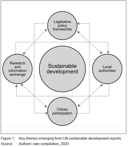
Figure 1 depicts that UN reports placed the emphasis for sustainable development of human settlements on these interrelated and interconnected themes: legislative policy frameworks, local authorities, citizen participation, research, and information exchange. Central to this article are legislative policy frameworks and spatial planning instruments. These instruments are critical, since they provide principles, concepts, goals and targets for achieving sustainable development (Shen & Kawakamai, 2013: 2; UN, 1976: 10). Similarly, the leitmotiv1in various spatial planning legislative policy frameworks in South Africa resonates with UN recommendations, by echoing the call for spatial transformation and sustainable development.
These legislative policy frameworks include the Reconstruction and Development Programme (RSA, 1994); the Development Facilitation Act 67 of 1995 (RSA, 1995); the Urban Development Framework (RSA, 1997); Breaking New Ground (RSA, Department of Housing, 2004); the National Spatial Development Perspective (2003; 2006); the National Development Plan (NDP) 2030 (RSA, National Planning Commission, 2012); the Spatial Planning and Land Use Management Act 16 of 2013 (RSA, 2013); the Integrated Urban Development Framework (IUDF) (RSA CoGTA, 2016), and the Draft National Spatial Development Framework (RSA, 2019). These efforts are well commended and highlight the attention of this article, which seeks to assess the overarching legislative policy directions steering spatial transformation and sustainable development in Polokwane City.
In addition, the UN reiterates that urban policies and strategies are critical in steering spatial transformation to ensure sustainable development of human settlements. In this set-up, local authorities act as key role players in facilitating the implementation of legislative policy frameworks and spatial planning instruments. The UN strongly recommends capacity-building, support of all forms from all spheres of government, other institutions, and international support to ensure sustainable development. There is no doubt that local authorities have a critical role to play in ensuring that sustainable urban forms are embedded in local spatial planning policy frameworks and strategies (UN, 1987: 246). This is also evident in the South African context. The Constitution tasks local governments with the developmental mandate to ensure spatial transformation and sustainable development.
Citizen participation and partnerships is another theme being echoed provocatively to support the realisation of the ethos of the right to the city concept and notion to urban development (UN, 2017: 5). Citizens, particularly the previously marginalised, must be involved in decision-making processes on the development and implementation of legislative policy frameworks and spatial planning strategies for the sustainable development of cities (UN, 1987: 248; 1976: 71). At the same time, research and exchange of information on experiences and innovations across all cities (from small, intermediate and metros) is another theme weaving through these UN reports on sustainable development. Further emphasis is placed on adopting applied science research such as capabilities of Geographic Information Systems (GIS) and remote sensing in monitoring and evaluating the environmental impacts of human settlements development across all city scales (UN, 1996: 153; 1976: 70). This theme calls for knowledge-sharing on the progress made by various cities worldwide to assist in identifying the best and worst practices on sustainable development. This ensures that no city can be left behind in the global action for sustainable development.
Gorzym-Wilkowski (2017: 76) reiterates that theoretical literature boldly points to spatial planning as a crucial mechanism for developing sustainable human settlements. However, a critical review of various legislative policy frameworks and urban strategies of different cities worldwide shows lack of agreement on what is a desirable sustainable urban form (Jabareen, 2006: 39). Milder (2012: 263) argues that some critics view compact urban form as the "magic bullet" to sustainable development, yet other critics do not. Other sustainable urban forms emerging from the literature include urban containment, neo-traditional development, new urbanism, smart growth, and eco-city (Shen & Kawakamai, 2013: 2; Jabareen, 2006: 44-46). In the absence of an agreed sustainable urban form, cities worldwide have put forward policy frameworks providing principles and concepts to guide development in their own contexts. The identified key concepts and practices include housing development, compactness, sustainable transport, density, mixed land-use patterns, diversity, passive solar design and greening design, agricultural, ecological, and smart cities (UN, 2016: 109; 1987: 235-253; Shen & Kawakamai, 2013: 1; Jabareen, 2006: 39-43).
The identified sustainable urban forms and concepts emanate from research mostly in the Global North (Shen & Kawakamai, 2013: 2). However, development trajectory in the Global South is not attributed to following a carbon-copy fashion, the growth and development path that occurred in developed countries. It is attributed to the need to redress colonial developmental ideologies of spatial segregation that created unsustainable urban forms. South African legislative policy frameworks and spatial planning practices are concentrating on spatial transformation, in order to redress apartheid unsustainable urban forms (Marais et al., 2019: 10). The government has also shifted focus by showing renewed interest in understanding and supporting sustainable development of small, medium and intermediate cities (Marais et al., 2019: 6).
The discussion on key themes from reports on sustainable development resonates with the conceptual spatial triad framework, a key element of Lefebvre's (1991: 33) production of space theory. This framework postulates that there are three interrelated components that help explain the production of space, namely spatial practice, representation of space, and representational space. Spatial practice (perceived space) denotes the spatial reality in society and that it secretes itself. This element entails that the way to understand socio-spatial reality in our cities is to continuously undertake research, reflection and exchange of ideas. Similarly, deciphering of the society on development patterns and unprecedented population growth projections by various experts resulted in a collective understanding that ushered the global call for sustainable development. It is evident that experts agree that the current spatial practice on production of space, if left unchanged, 'propounds and presupposes' unsustainable development patterns. Representational space (lived space) refers to the space lived, inhabited by citizens and other users, that sought after to be changed. Representation of space (conceived space) is dominant in the production of space. It is the space of experts who decipher the nuisance in lived and perceived spaces to conceptualise better spaces. In the context of this article, this element is tantamount to governments, experts and other key stakeholders that are continuously establishing legislative policy frameworks. Their quest is to provide a conceptualisation of the desired sustainable development, in order to meet the needs of the current generation in a way that does not undermine future generational needs.
In the case of South Africa, spatial transformation refers to the process of planning and managing development and unlocking opportunities in human settlements through strategic placing of economic activities, social services and infrastructure development, in order to redress colonial and apartheid spatial segregation patterns manifesting in inequalities, inefficiencies and injustices (NSDF, 2019: 20). Spatial transformation can thus be viewed on a means-end continuum. It is, therefore, the means, a process to redress the apartheid legacy of spatial injustice and the attainment of desired sustainable development. It is also aimed at changing the current unsustainable urban forms of post-apartheid cities' growth and development trajectories which exacerbates fragmentation, and spatial inefficiencies which impact on the environment (Marais et al., 2019: 10; NSDF, 2019: 20). This is achieved through spatial planning and development normative principles of various legislative policy frameworks employed by local authorities to develop sustainable human settlements that are spatially just, efficient, resilient, well governed and in balance with nature (Marais et al., 2019: 10; SACN, 2017: 15). Spatial transformation, as an end-result of spatial planning efforts by local authorities, thus has the potential to bring about desired sustainable urban forms that are compact, dense, and integrated through concepts such as high-density, infill developments, integration, and transit-oriented developments (TOD), among others (Chakwizira, Bikam & Adeboyejo, 2018: 85).
3. CASE STUDY AREA
Polokwane City (formerly Pietersburg) (see Figure 2) is categorised as an intermediate city in South Africa. Pietersburg was established in the 1880s as a regional centre servicing colonial settlers in the former Zuid-Afrikaansche Republiek (ZAR) (SACN, 2017: 36). The city's narrative chronicles that it was established with principles of conservatism and racial segregation embedded in the spatial, social fabric, residential and business sectors (Donaldson & Kotze, 2006: 571; Donaldson, 2005: 355; Kotze & Donaldson, 1998: 469). The development of Polokwane's urban core started with a survey of 150 plots in 1884 during the colonial period. In 1885, 94 of these plots were handed over free to White settlers who had been displaced from Schoemansdal area, because of frequent attacks by Black Africans, and the remaining plots were sold.
Urbanisation in Pietersburg dates back to the early 1890s. The pioneering group of people who moved from New Smitsdorp caused the population to rise to =200 people by 1889 and to =800 people by 1893 (Weiner, 2006: 30). This increase is also linked to the survey of =261 erven north-west of Pietersburg, as a result of the 1890 provision for the establishment of an Asian location physically segregated from the White areas by the railway line. This area was later subdivided, creating adjoining locations for Blacks and Asians (Kotze & Donaldson, 1998: 469). Pietersburg's population further increased as a result of the concentration camp, built by the British, for =4 000 Boer women, children and the elderly men who could not fight during the South African wars (1899-1902). In the 1930s, Blacks were offered an opportunity to own property in New Pietersburg Township, an area initially zoned for Whites.
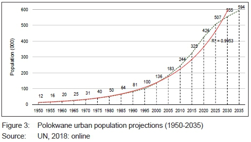
The apartheid era started in 1948, and its legislations such as the 1951 Bantu Authorities Act and the 1950 Group Areas Act provided directions for the grand apartheid on the reorganisation of residential areas, ending the mixing of different races. Consequently, Westenburg suburb for Coloured people was proclaimed in 1965, followed by the proclamation of Nirvana Indian suburb in 1973 (De Villiers & Kalema, 2005: 82). Seven farms of Seshego (then Moletsie), in the former Lebowakgomo homeland, were selected for the establishment of a segregated dormitory Black township in the 1970s (Cloete & Massey, 2017: 154; De Villiers & Kalema, 2005: 83; Donaldson, 2001: 208). These were then divided into eight zones for the planned development of =12 000 erven; this subsequently increased the population for the current urban core (Donaldson, 2001: 209). The township served as a permanent place of residence for Black migrant labourers working in White areas and for those who were forcefully removed from New Pietersburg, Rouxville and other White locations in the 1970s (Cloete & Massey, 2017: 154; Donaldson, 2001: 208). Apartheid planning and its spatial segregation ideologies did thus not uphold the principles of sustainable development. It promoted an unsustainable urban form, by removing Blacks from areas from which they could previously walk to their work places, to Seshego, an area located ±11km away so that they had to commute, thus impacting on socio-economic and environmental dimensions. In addition to this unsustainable urban form and development trajectory, Figure 3 shows that Polokwane City is continuously experiencing rapid urbanisation at an exponential rate, correlation co-efficient R2 = 0.9953. This relationship shows that the urban population of Polokwane City is still expected to rise at an unprecedented rate. In particular, the urban population was =12 000 in 1950, and it is projected to be =594 000 in 2035. Therefore, there is a need to take heed of the global call for action in promoting sustainable development, in order to ensure that the present generation utilises the available resources to meet their needs in the fight against apartheid injustices, without jeopardising the future generation from meeting their own needs. Legislative policies play a critical role in facilitating sustainable development and mitigation of climate change. It is thus critical to share knowledge and experiences on the sustainable development pathways across all cities, without being skewed to major cities. This warrants the need for understanding the actions and directions provided by legislative policy frameworks to ensure spatial transformation and sustainable development in Polokwane intermediate city.
4. METHODOLOGY
4.1 Research design
This article adopted a literature review approach in investigating the legislative and policy directions for spatial transformation and sustainable development in Polokwane intermediate city. This approach was guided and modelled along the case study research strategy underpinned by the pragmatic research paradigm as highlighted by Creswell & Clark (2018: 52), Leavy (2017: 13), Creswell (2008: 10), as well as Mackenzie and Knipe (2006: 196). The discussion on methods adopted for data collection and analysis for this article was modelled around systematic review by Rantsatsi, Musonda and Aumba (2020: 125-133) and desktop review by ten Ham-Baloyi & Jordan (2016: 123) and Khan, Kunz, Kleijnen and Antes (2003: 188).
4.2 Search strategy
A literature review was employed to determine the legislative and policy directions for spatial transformation and sustainable development in Polokwane City. This review largely consisted of legislative and policy framework plans between 1996 and 2016, which were initially collected in February 2019 as part of a broader study on spatial transformation in Polokwane City (1996-2016). The documents were collected through a Universal Serial Bus (USB) flash drive during key expert interviews with officials from the Limpopo Department of Cooperative Governance Human Settlements and Traditional Authorities (CoGHSTA) and from Polokwane City: Directorate of Planning and Economic Development within the unit of Land Use Management and Spatial Planning. This secondary data was also supplemented by additional literature collected as part of the aforementioned broader study, through a free search between 1 April 2017 and 30 March 2020. The main database search included Google, Google Scholar, Scopus, and University of Venda (Univen) Library databases. Univen is subscribed to a total of 19 library databases (EBSCOhost, Science Direct, JSTOR, Web of Science, among others) and seven legal databases (South African Government Website) that were consulted. The tools used to perform the free search in the databases include search phrases, using Boolean terms (AND, OR, NOT), keywords, abstracts, and titles. The search entries were employed in two phases; the initial search was broadly focused on descriptions of spatial transformation in Polokwane City. The second search was focused on spatial segregation, legislative and policy descriptions on sustainable development in Polokwane City.
4.3 Inclusion and exclusion criteria
Inclusion criteria:
• Documents contextualising apartheid unsustainable, spatial segregation development patterns in Polokwane intermediate city.
• Policy frameworks guiding spatial transformation and sustainable development within the urban edge of Polokwane primary node prior to 2016.
• Documents providing conceptualised representation of spatial transformation and sustainable development in Polokwane intermediate city.
• Documents describing mechanisms steering spatial transformation and sustainable development in Polokwane intermediate city between 1996 and 2016.
• Exclusion criteria:
• Legislations and policy frameworks from 2016 onwards.
• Policy frameworks guiding spatial transformation and sustainable development in areas outside Polokwane primary node.
• General dissertations, theses, papers, legislations and policy frameworks that do not mention spatial transformation and sustainable development in Polokwane City.
4.4 Identification of studies
The study also includes additional relevant literature that was identified from the reference list (Rantsatsi et al., 2020: 127) and from specific sections discussing development legislative and policy context from policy framework plans. Some of the additional documents do not form part of the core aim of this article. However, they were essential in framing the case study area background on unsustainable development urban form, a characterisation of spatial segregation in Polokwane intermediate city. This contributed to loosening the search restrictions from legislations and policy documents, to also include journal articles, doctoral or master's dissertations.
4.5 Search findings
The search findings of the literature collected between 1 April 2017 and 30 March 2020 resulted in a database of 116 documents. This database consisted of 67 legislative and policy frameworks plans that were collected initially during the expert interviews. This secondary data was then screened, guided by the inclusion and exclusion criteria. Additional evaluation tools such as checking titles, abstracts, content skimming and scanning were also used. Those documents that were found to be not relevant were dropped. The remaining secondary documents that were considered essential towards framing the directions for spatial transformation and sustainable development in Polokwane City include a total of 28 documents (five articles, one dissertation, three legislations and 19 policy frameworks (see Table 1).
From the analysis of information presented in Table 1, it was deduced that directions for spatial transformation and sustainable development integrated from the local policy framework plans are comprehensive and unbiased, as they were developed by multiple experts and practising planners. The methodology adopted in collecting data that informed the development of Polokwane local policy framework plans was also assessed. The findings revealed that the consultants adopted various methods of data collection, including status quo analysis, literature review, questionnaire, face-to-face interviews, focus-group discussions, stakeholder engagements, IDP forums, public consultation meetings, media, websites, Traditional Authorities and Municipal Cluster Offices, mapping, spatial analysis and modelling using GIS (Polokwane, 2001; 2005; 2007a; 2007b; 2008; 2009a; 2009b; 2010; 2013a-d; 2014). Upon considering all the available information outlined in these steps, the authors of this article consented that selected legislative policy frameworks suffice and are good fit for analysis to unravel the directions for spatial transformation and sustainable development in Polokwane intermediate city, South Africa.
4.6 Analysis of identified literature
Thematic analysis was adapted, guided by a deductive reasoning approach, to analyse the identified documents presented in Table 1. The initial analysis resulted in arranging and grouping identified documents according to their relevance in achieving the pre-conceived key themes that emerged from the research objectives of this article.
These themes include overarching legislations policy frameworks and normative principles, as well as conceptualised geospatial representation of space and local policy mechanisms steering spatial transformation and sustainable development in Polokwane intermediate city.
Furthermore, an analysis of policy framework plans relating to the third theme revealed the mechanisms or instruments steering spatial transformation and sustainable development in Polokwane City: urban containment, strategic development areas, land ownership and housing, densification/compact city, spatial targeting, sustainable transport, secondary land-use nodes, greening, and smart city development. Section 5 discusses the findings on these mechanisms and aforementioned themes.
4.7 Limitations
Polokwane City GIS Unit, under the directorate of Planning and Development, was visited in February 2019 to gather interoperable geospatial datasets relevant in the (re)construction of conceptualised representations of space that provides directions for spatial transformation and sustainable development. The municipal geospatial database was limited to shapefiles for the years 2014 onwards, as the previous database failed and historical spatial data could not be retrieved. This limitation was addressed, using GIS ArcMap, version 10.5 tools. GIS innovative tools helped attain the second objection through the (re)construction of a conceptualised representation of space compiled from various policy framework plans for Polokwane City (Polokwane, 2007a; 2007b; 2009). In particular, ArcMap conversion tools (pdf to tif images), geo-referencing, and digitising were employed to (re)construct the boundaries of strategic development areas (SDA) 1 (Polokwane, 2007a), SDA 2 (Polokwane, 2009), and SDA 3 (Polokwane, 2007b). The results from employing ArcMap tools was the (re) construction of a comprehensive map representing the policy frameworks directions for spatial transformation and sustainable development (see Figure 5). GIS ArcMap map projection tools were also employed to change data from geographic coordinate systems (GCS) Hartebeesthoek 1994 to projected coordinate system (PCS) (WGS_1984_World_Mercator) for computation of land area coverage in hectares. This function was useful in this study, as it assisted in the computation of land area for the urban edge, urban fringe, future development area and the conceived urban edge built-up land area.
5. RESULTS AND DISCUSSION
5.1 Legislative policy directions for spatial transformation and sustainable development
5.1.1 Legislative policy normative principles directing spatial transformation
The UN recommendations and underpinnings of the representation of space, an element of Lefebvre's (1991: 38) production of space theory, concur that the substance of legislative policy frameworks is critical for the advancement of sustainable development. In light of this perspective, this article analysed the overarching legislations and policy frameworks that acted as main planning anchors, in order to identify the directions for spatial transformation and sustainable development in Polokwane intermediate city for the period 1996 to 2016. Figure 4 succinctly summarises the evolution of key legislative policy frameworks that featured predominantly during discourse analysis. Key substance weaving through these legislative policy frameworks are principles framing the directions for spatial transformation and sustainable development, whilst redressing the implications of apartheid planning. Employing the lens of the spatial triad, it is apparent that the pre-1994 apartheid spatial practice and ideologies on the representation of space disregarded the principles of sustainable development. This accounts for spatial segregation, an unsustainable form that is still inherent in South African cities. It is to this end that a paradigm shift has been witnessed in both the transition and post-apartheid periods towards the establishment of progressive legislative policy frameworks informing spatial transformation and sustainable development.
The White Paper on Reconstruction and Development Programme (RDP) (1994) marks the dawn of progressive legislative policy frameworks that advance a Global South agenda. This radically changed representation of space towards redressing colonial-apartheid planning through spatial transformation, whilst taking heed of the global call for sustainable development. In particular, the fundamental shifts, noted as relevant to this article, are planning principles emanating from RDP (1994), including integration, sustainability, people-driven process in reshaping the urban form, and the development of human settlements.
To pave the way for the implementation of spatial transformation and sustainable development directions linked to the RDP 1994, radical normative planning principles were introduced by the DFA Act 67 of 1995. The following spatial planning principles were introduced to facilitate land development and desirable urban forms: inclusiveness of all human settlements, efficiency, integration, sustainability, walkability, mixed use, compact city, justice, and good governance. However, the RDP programme is criticised for running short of providing a physical development plan (representation of space) that provides targeted areas for human settlements development (Drewes & Van Aswegen, 2013: 195). To address this shortcoming, the promulgation of the Municipal Systems Act 32 of 2000 (RSA, 2000) resulted in the operationalisation of the RDP and DFA principles. This was facilitated through mandatory directions that local authorities must develop Integrated Development Plans (IDPs) and Spatial Development Frameworks (SDFs).
The NSDP (2003, updated 2006) was formulated to further expand on the available spatial planning principles. It introduced radical principles such as spatial targeting and concentration of capital investment, human capital development, as well as corridor and nodal development.
Further deciphering of the spatial practice raised new perspectives leading to the conceptualisation of additional principles and approaches to attain the desired spatial transformation and sustainable development. This is witnessed from the establishment of BNG (RSA, 2004), providing directions on the development of sustainable human settlements, and NDP 2030 (NPC, 2012), a national spatial planning and development vision. Furthermore, the spatial planning challenges and criticisms levelled against the DFA 67 of 1996 culminated with the establishment of SPLUMA 16 of 2013. SPLUMA is referred to as the first national spatial planning instrument for the Republic of South Africa. It concretised the overarching spatial planning principles from DFA 67 of 1995 (repealed) and other relevant pieces of legislative policy frameworks, in order to provide directions on spatial transformation and sustainable development. The identified principles from SPLUMA include spatial justice, resilience, efficiency, sustainability, and good administration. The efforts of the South African Government and other stakeholders is acknowledged for the progressive establishment of legislative policy frameworks guiding spatial transformation in our cities. It is important to note that this does not mean that the range of principles identified are unique; rather, that the ideology of adopting these principles is not an establishment, carbon copy or following a similar developmental pathway with cities in the Global North. The agenda of the post-colonial democratic dispensation is centred on redressing colonial spatial injustices, unsustainable urban forms and associated environmental impacts. There is thus a need to unravel how these identified principles have been operationalised in Polokwane intermediate city to steer spatial transformation and sustainable development in the Global South.
5.2 Polokwane City: Local policy directions for spatial transformation and sustainable development
This section discusses the application of legislative directions for spatial transformation and sustainable development, as conceptualised in the local policy documents for Polokwane intermediate city. In view of Lefebvre's (1991: 36) spatial triad framework, particularly the representation of space, this section explores how Polokwane City has conceptualised legislative overarching principles and concepts in its local policy frameworks. This helps understand how these generic instruments at the disposal of cities of all sizes are being adopted and their relevance in guiding spatial transformation and sustainable development in small and intermediate cities. As a starting point, in Figure 5, GIS was employed to combine and present a map showing the collective conceptualised directions featuring in various local policy and planning documents for Polokwane intermediate city. This details the representation of space, an element of the spatial triad, graphically providing the emergent conceived directions for the development of a sustainable urban form. The theoretical approach underpinning the adoption of the overarching principles and concepts on spatial transformation and sustainable development in Polokwane intermediate city is the spatial concentration model combining selective cluster approach in rural areas (Abrahams & Marais, 2019: 186; Polokwane, 2010: 163). This approach is crucial, as it helped the city advance its developmental mandate, despite the fiscal challenges and the low revenue base. This scenario is furthe aggravated by the spatial compositio of the city consisting of 71% rural, 23% urban and 6% recreational, industrial land, institutional, and small holdings. These challenges are somewhat prominent in most of the small and intermediate cities. The case of Polokwane City is a learning curve on how cities in the same category can navigate so as to promote spatial transformation and sustainable development.
5.2.1 Urban containment
The discourse analysis of local policy frameworks for spatial transformation in Polokwane City shows that urban containment is the overarching sustainable urban form adopted. This instrument is aimed at facilitating and unlocking the broader economic, social, cultural and environmental dimensions of sustainable development. According to Jabareen (2006: 45), urban containment is facilitated by various polices that provide direction on sustainable development by limiting the extension of infrastructure services and utilities in outlying areas, in order to prevent spatial splintering of cities, and the uptake of valuable agricultural lands. Similarly, Polokwane (2010: 203) reiterates that it supports sustainable development through urban containment by providing directions for spatial transformation that include densification, integration, urban infill, bulk infrastructure, service developments and maintenance, protection of environmentally sensitive areas and agricultural areas, township establishments, and economic development activities.
Similarly, Polokwane policy frameworks reveal various urban containment tools to facilitate spatial transformation and sustainable development of human settlements. Abrahams and Marais (2019: 191) reiterate that Polokwane development policy frameworks identified the urban edges to guide spatial transformation activities. Thus, sustainable development tools (see Figure 2) that emerged from the policy discourses are urban edge (=20 429ha), urban fringe (12 583ha), future development area (39 601ha), and the urban development zone (150ha) (Polokwane, 2010: 167; 2008: 128).
In addition, computed conceived built-up land area indicates that roughly 13 810ha (67.5%) of land in the urban edge is developed. This is attributed to infill developments. Plans for township establishment are approved for most of the vacant land falling between Seshego and Polokwane Central. These proofs and experiences of spatial transformation and sustainable development, fostered through spatial integration of settlements within the urban containment boundary, illustrate the challenges and opportunities for policy direction in the study area. The development of such a sustainable urban form is also reinforced by legislative policy directions limiting spatial transformation activities in the urban fringe or transition zone. These restrictive conditions include protecting agricultural land and environmentally sensitive areas and promoting urban agriculture. Polokwane (2010: 203) points out that at least 90% of the urban edge must be developed. However, on bases of exceptional merit, developments are permitted in the urban fringe. Nevertheless, the municipality does not fund bulk and other external services. These experiences within Polokwane intermediate city show that urban containment is a key tool influencing sustainable development of cities worldwide.
The incentives approach is also part of the mechanisms used to enhance the role of urban containment by influencing land use, development growth and management in facilitating sustainable development (Jabareen, 2006: 45; Latief, Ohgai & Leleito, 2011: 232). The basis of this ideology is that the aftermath of rapid urbanisation in developing economies, inclusive of small and intermediate cities, results in the epidemic of urban decay, requiring incentive regenerative approaches to change the unsustainable growth trajectories. Similarly, Polokwane CBD, the main primary activity node, a critical contributor to the city's economy through Gross Domestic Product (GDP), is also experiencing rapid general dereliction, decay, and accelerated depreciation, as businesses on the outskirts contributed to socio-economic pressures of the unprecedented rapid urbanisation. To curb this 'nuisance of unsustainable development', an urban development zone (UDZ) for Polokwane CBD was promulgated, dated 2005, covering the following functional zones: offices, trading, retail, accommodation and transition, with the exception of institutional and infill zones (Polokwane, 2008: 128). The UDZ promotes sustainable development by providing property owners and developers with spatial transformation tax incentive overtime to revitalise, develop, combat dereliction, optimise use of resources, promote compact cities, and improve inner city aesthetics. This discourages unsustainable developments, which manifests in spatial splintering, thus exacerbating injustices of spatial segregation inherent in the city.
5.2.2 Strategic development areas
A discourse analysis of policy frameworks reveals that, at a micro spatial planning level, Polokwane identified strategic development areas (SDAs), giving effect to spatial concentration model and urban containment (see Figure 5). They complement development activities within the urban edge without compromising the primary functions of the CBD. SDAs are referred to as focal, primary areas where investment, development and expansion must be prioritised for the development of spatially just and sustainable human settlements (Polokwane, 2010: 169; 2007a: 7).
In addition, Polokwane (2010: 115; 2007a: 8) pointed out that 2007 SDF mandated Polokwane to facilitate and promote spatial transformation and sustainable development leveraging on SDAs by providing bulk infrastructure services, development incentives, fast-tracking application procedures for land development, and development of local spatial framework plans (LSFPs). In line with this perspective, LSFPs were developed, namely 2009a LSFP SDA2 Ivydale Agric holdings; 2007 LSFP SDA1 areas between Polokwane central and Seshego, and 2007 LSFP SDA3 Eastern suburbs of Polokwane and adjacent areas to the east. These LSDFPs are dated, and the intent is to support sustainable development by providing guidelines for decision-making on development applications; spatial planning; land-use planning; environmental management, and to give effect to the objectives of the macro SDF, IDP and other sector plans (Polokwane, 2017a: sec. 11). Thus, aggregating the SDAs, as presented in Figure 5, formulates a completed conceptualised spatial plan puzzle for the Polokwane-Perskebult cluster urban edge. Key instruments for spatial transformation and sustainable development emanating from this conceived spatial plan puzzle include land ownership, housing development, shopping facilities, multi-purpose community centres, transport networks, and environmental protection.
5.2.3 Land ownership and housing development
The ability of local government to contribute to the global call for action in promoting sustainable development and spearheading spatial transformation in redressing the apartheid legacy of spatial injustice is determined by how much public land they own, its availability and desirability for development. Polokwane (2013e: 11) echoes that publicly owned land is an invaluable asset for attaining legislative policy goals.
Despite a lack of local policy review after boundary changes for SDA1, Table 2 clears the uncertainty and dynamics on the public landownership question within the Polokwane urban edge. The computed land area from the conceived boundaries for the SDAs shows that approximate publicly owned land is as follows: 1 958ha (58.8%) of 3 325ha for SDA1 (based on 2007 boundary), 67ha (6.3%) of 1 057ha for SDA2, and 1 230ha (38.5%) of 3 195ha for SDA3. Correlations and implications of such proportions of public landownership are that, where government owns a great deal of land, such areas experience land development activities at a faster rate than in other areas. In particular, government owns a great deal of land in SDA1, an area reckoned for successful spatial transformation in formulating an integrated and sustainable urban form.
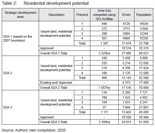
Polokwane City is also leveraging on housing development as a mechanism for spatial transformation and sustainable development (see Figure 5). The bulk of the land in the urban edge is anticipated to accommodate the rising municipal urban housing backlog estimate of ±33 873 (Polokwane, 2019: 102), which increased from an estimate of =22 000 in 2007 (Polokwane, 2007a: 49). Table 1 presents the anticipated residential developments for the vacant land identified in each SDA. This is aimed at providing people with decent shelter and redressing the apartheid legacy of spatial injustice and inequality exacerbated by unprecedented rapid urbanisation.
Table 2 shows that, a decade ago, Polokwane SDAs 1, 2 and 3 policy framework plans identified the potential development of 69 517 erven on the vacant land in the urban edge, which exceeds the current identified urban housing backlog of ±33 873 (Polokwane, 2019: 102). This housing development potential in Polokwane urban edge leverages on existing bulk services, transport infrastructure and close proximity to areas of opportunities. The policy intent of limiting housing development within the urban edge to contain rapidly increasing urban population thus greatly contributes to sustainable development. The backdrop to this mechanism is that desired housing development is mostly noticeable in publicly owned land areas, compared to privately owned land. Overall, this provides lessons that the policy frameworks strategic spatial plan puzzle is essential in providing development directions in a manner that promotes the development of integrated sustainable urban forms.
5.2.4 Densification - compact city
Urban containment on its own is not effective in contributing to the desired spatial transformation and development of sustainable urban forms; other complementing tools are also needed. In this regard, the Polokwane densification policy was established in 2013 to aid in urban containment and redress remnants of apartheid spatial segregation that resulted in unsustainable urban form characterising low to medium densities. Various legislative policy frameworks reviewed echo the significance of densification in providing directions for sustainable development and spatial transformation towards redressing apartheid spatial legacy of spatial mismatch (Polokwane, 2013b:114; 2010: 128; 2007a: 39; NSDP, 2006: xii; BNG, 2004: 19; DFA 67 of 1995). Densification refers to the increased vertical or horizontal use of space, by increasing the number of units, population threshold incrementally for existing or, from the onset, in newly developed human settlements (Polokwane, 2013b: 8; RSA DRDLR, 2011: i). Polokwane (2013b: 115) takes note of these directions, indicating that existing vacant areas between Polokwane and Seshego can amount to =6 488 stands (11%) of the total 58 692 stands, leading to a potential density increase of 12.07 units per hectare. Furthermore, Polokwane (2007a: 41) pointed out that the Nelson Mandela Drive provides an opportunity for high residential density developments of 80 units/ha, compared to the average density of 30 units/ha in other areas. This, in turn, increases population densities, supporting the viability of integrated rapid public transport networks, mixed land uses, and the decentralisation of economic opportunities to the densely populated nodal township settlements.
5.2.5 Spatial targeting: Development corridors and functional development areas
Spatial targeting approaches are also used in Polokwane, augmenting urban containment to attain the desired spatial transformation and sustainable development, namely development corridors (DCs) and functional development areas (FDAs) (see Figure 5). The concept of development corridors (economic corridors) is widely considered a key spatial planning instrument for redressing the economic, social and spatial challenges faced by cities that are central to the concept of sustainable development. Literature points out that a corridor development approach influenced spatial transformation and sustainable development in Curitiba, Brazil (Rosário, 2016: 115; Lindau, Hidalgo & Facchini, 2010:17). In the South African context, NSDP (RSA, 2006: 6) promotes spatial transformation and sustainable urban form by channelling development activities along corridors linking key nodes.
Similarly, Polokwane (2010: 157) is harnessing opportunities created by prominent routes linking municipal nodes and clusters to facilitate integrated transport and land-use management, in order to unlock economic opportunities that foster sustainable development. Two key DCs and Ave FDAs connecting various nodal areas are identified (see Figure 5). DC1 route linking Gauteng/Pretoria-Polokwane-Mankweng/Tzaneen nodal areas and DC2 route linking Makhado-Polokwane-Burgersfort/ Chuenespoort. The integrated land uses along Polokwane FDAs are also fostering sustainable development through F1: integrated rapid public transport network; F2: motor trading; F3: medical node, and F4: industrial hub, with F5 lagging behind its tagged long-term development area. It is important to note that Polokwane had long acknowledged the role of FDAs. Medical land-use initiatives along F3 started in early 1988 and were further strengthened by City of Polokwane 1998 Land Development Objectives in line with the DFA of 1995 (Polokwane, 2001: 5-7). This shows that Polokwane City is capitalising on these DCs and FDAs in fostering sustainable development.
5.2.6 Sustainable transport: Integrated Rapid Public Transport Network System - Leeto la Polokwane
The heralded success of Curitiba Brazil in the sustainable development and restructuring of the city is attributed to policy directions on investment in transport systems (Rosario, 2016: 113). Thus, leveraging transport infrastructure plays a significant role in facilitating spatial transformation and development of a sustainable urban form. This is attributed to the inextricable relationship that exists between transport and land uses, where the transport network infrastructure attracts high-density land-use developments, promoting sustainable development. This is echoed by Polokwane legislative policy frameworks substantiating the need for the development of transpor networks to ensure a sustainable urban form. These policy frameworks include Public Transport Integration Corridor Development Plan alongsid Nelson Mandela Drive, August 1999 (cited in Polokwane, 2007a; 2007b; 2009a); Integrated Urban Realm and Movement Plan for Polokwane Municipality (IURMP) (2009) (cited in Polokwane, 2010); Comprehensive Integrated Transport Plan Polokwane Local Municipality (Polokwane, 2013a); Operational Plan for the Implementation of the Integrated Rapid Transit System Polokwane Local Municipality (Polokwane, 2014).
These policy frameworks show that Nelson Mandela Drive exemplifies a sustainable transport network corrido heavily invested on for its potential contribution to spatial transformation and the development of a sustainabl urban form. It spatially integrates formerly segregated Seshego township and Polokwane centre. Owing to this success, Polokwane City initiated the upgrading of Nelson Mandela Drive into an integrated rapid public transport network (IRPTN), named Leeto la Polokwane, which means 'the journey of Polokwane' (Abrahams & Marais, 2019: 188). This IRPTN is along the high-traffic demand corridor stretching ±40km to Moletji settlement cluster. Polokwane (2014: 16) substantiates high traffic volumes from Moletji-Seshego towards the CBD of 17 425, making it feasible for an IRPTN, compared to 9 535 for Polokwane-Mankweng corridor. It is also pointed out that ±80% of the land area along the corridor is characterised by residential areas, making it highly suitable compared to the R71 corridor, which has limited residential development.
Other parts of this bus rapid transport (BRT) network trunks are extended to run on some residential streets, reinforcing the development of a sustainable urban form. This IRPTN is further linked to the pedestrianisation of high pedestrian volume streets, which include Nelson Mandela Drive link to the CBD =2 550 pedestrians and Seshego link to New Polokwane =1 820 pedestrians (Polokwane, 2014: 62). These high pedestrian volumes warranted the development of the IRPTN promoting walkability, a sustainable urban form. This is a learning curve showcasing how small and intermediate cities are also rising to the global agenda and striving for development of sustainable urban forms.
The notable proposed development of a national distributor road, N1 bypass for Polokwane, is another typical example of sustainable transport initiatives in small and intermediate cities. Polokwane (2007a: 30) indicates that the eastern road should be upgraded as the N1 bypass or ring road (see Figure 5). This N1 bypass road formulates a key functional development area that unlocked economic opportunities, resulting in the development of a regional shopping complex, Mall of the North. The bypass road also contributes to a sustainable urban form, as it reduces through traffic from Polokwane CBD, which was contributing to increased traffic congestion and emission of the harmful greenhouse gases that impact on the environment.
5.2.7 Secondary land-use activity nodes: Shopping centres and multipurpose community centres
Developing secondary activity nodes is essential in providing a complete sustainable urban form puzzle plan that helps reduce the implications of development on the environment. This contributes to having mixed land uses and to people not needing to travel long distances to access goods and services, thus reducing greenhouse gas emissions that impact on the environment. Polokwane echoes this view, not only that there are proposed or approved retail plans, but that it has already developed several shopping centres and multi-purpose community centres (MPCCs) to facilitate spatial transformation and the development of sustainable urban forms. Polokwane (2007a: 31) substantiates this, stating that shopping facilities are limited for convenient access to goods and services. People had to travel long distances from rural areas and townships to access economic opportunities and utilities such as retail centres located in the major towns and cities where affluent people reside.
Efforts in redressing such unjust economic distribution are acknowledged. Polokwane (2007a: 51) pointed out that, for the initial 2007 SDA 1 boundary, =100 000m2 of retail space was estimated. This is in line with the required population threshold between 80 000 to 100 000 people, as SDA 1 anticipates catering for roughly 86 021 people (see Table 1). This entails that the policy directions encourage the development of shopping centres as leverage for spatial transformation and sustainable development.
The concept of developing MPCCs also gained traction as a tool for the development of sustainable urban forms and spatial transformation in post-apartheid South Africa. A MPCC refers to "a focal point at which a comprehensive range of essential services can be obtained by people living in its vicinity" (Polokwane, 2007a: 56J. These community centres also act as a one-stop centre, a nucleus node attracting other economic activities and bringing service functions closer to previously disadvantaged people. This reduces multiple long-distance trips to previously apartheid-affluent town centres, fostering development of sustainable urban forms. In support of this, Polokwane (2007a: 51) points out that eight MPCCs are proposed for development in SDA 1 and another Ave are proposed in SDA 3 to promote a sustainable urban form, serving various functional settlements in the urban edge (Polokwane, 2007b: 43).
Polokwane (2007a: 51) also reiterates that MPCCs are expected to result in a concentration of people and activities, which then facilitates spatial transformation and the creation of sustainable development opportunities through public-private partnerships (PPPs) for the development of other businesses. This concept facilitates collaboration from various stakeholders, including local, provincial and national government spheres, to bring services to local communities.
5.2.8 Greening
The integration of green spaces in human settlements is critical for promoting the development of sustainable urban forms. Green spaces offer various economic, social and environmental benefits that impact on the microclimate such as reducing urban heat islands. Polokwane strives to promote sustainable development through greening; the green colour on its logo "signifies the commitment the city displays towards its environment and preserving such also, the natural magnificence it has to offer" (Polokwane, 2016: 23). In this regard, Polokwane developed a Greening Plan as mandatory requirement for hosting the 2010 World Cup. This plan identified greening thematic areas for investment, namely Carbon Emissions Management/ Offsetting, Energy Efficiency, Water Conservation and Management, Sustainable Waste Management, Efficiency of Transport and Access, Biodiversity and Ecosystem Services Management/Protection as well as Communication and Raising Awareness (Polokwane, 2009b: 15). This demonstrates the city's commitment to promote sustainable development by investing in greening strategies.
Polokwane (2005: 89) substantiates that policy directions are being provided to ensure that green spaces or public open spaces are integrated into the built environment, in order to promote sustainable development. Emphasis is being placed on improving the functionality, safety and security of major public open spaces such as Civic Square,
Sterkloop Spruit, and Siegfried Mare Park in the Polokwane CBD. The following tools are essential for this: designing, providing adequate lighting, street furniture, toilet facilities, complementary and compatible land uses (conference centres, restaurants, coffee shops, sports clubs or other permitted uses). Building coverage in public open spaces is limited to 20% (Polokwane, 2005: 89). However, the fact is that most of the public open spaces are poorly managed or neglected; they are breeding grounds for criminal activities, thus defeating the broader purpose of open spaces in promoting sustainable development.
The following efforts to promote sustainable development are worth mentioning. In the 1990s, Polokwane bought farms along the Sand River exclusively to preserve underground water for both current and future generations (Polokwane, 2007a: 33). In addition, an environmental sensitivity map showing the inventory of potential bullfrog areas, bird sanctuary, flood lines, sodic areas, natural drainage corridors ±300m, pristine Polokwane Plateau Bushveld and red data plants is provided to be integrated in guiding the sustainable development of townships in the urban edge (Polokwane, 2007a: 35; 2007b: 23). These environmentally sensitive areas are not only considered important for regulating the city's microclimate, but are also significant because of eco-tourism opportunities for both current and future generations (Polokwane, 2013c: 14).
5.2.9 Smart city development
In his State of the City Address on 10 June 2013, the then Executive Mayor, Councillor F. Greaver, intimated that adopting the smart city concept is the solution to resolving the challenges faced by the city (Polokwane, 2013f: 25). This shows strong political will in steering the municipality not only to attain its vision 2030 of becoming a smart city, but also to promote sustainable development. Polokwane challenged itself that the inherited apartheid challenges, exacerbated by rapid urbanisation, should be viewed as a driving force for technological innovation in service provision and sustainable development. The basis of this concept is that internet and communication technologies can be adopted and integrated into cities' infrastructure systems, strategic planning systems, rendering of municipal services efficiently and in a friendly manner, in order to safeguard the environment (Polokwane, 2013c: 33; 2013d: 2).
To achieve this concept, Polokwane adopted six elements as its guiding pillars, namely smart people, smart mobility, smart governance, smart environment and smart economy (Polokwane, 2013f: 26; 2016: 209). The city's commitment is also evidenced by aligning its scorecard or key performance areas (KPAs) to these guiding pillars (Polokwane, 2016: 241-262). To attain its 2030 smart city vision, the city set the following related ICT strategic objectives: to develop e-services, enterprise architecture, IT management and governance, secure IT infrastructure, Electronic Document Management System, and IT-competitive and -capacitated human resources personnel. Another strategy adopted by the municipality to attain this smart city vision is through the special project of Rural Broadband Connectivity. In this project, Polokwane seeks to develop a municipal wide broadband network infrastructure that includes wireless technologies, fibre optic and powerlines. In doing so, the municipality is open to collaborations in public-private partnerships in designing, managing and maintaining the broadband network infrastructure, in order to achieve the broader smart city vision (Polokwane, 2016: 209-213).
Furthermore, Polokwane (2016: 234) presents a bucketful list of themes to steer the city into achieving the vision 2030 smart city. The noticeable smart initiatives already taking shape include the implementation of IRPTN (Leeto la Polokwane), which is smart mobility. Smart living is evidenced by the launch of the smart metering system (Polokwane 2017b), which ensures that newly developed buildings are equipped with pre- or post-paid smart meters. These systems also seek to gradually replace the old electricity and water meters with prepaid and post-paid smart meters at no cost to consumers. This smart metering strategy promotes sustainable utilisation and conservation of scarce resources such as water and electricity, by reducing illegal connections and early detection of water losses.
5.3 Legislative and policy implications on spatial transformation and sustainable development
Polokwane committed itself to providing directions on spatial transformation and sustainable development, as reflected in local policy frameworks. However, achieving the global call on sustainable development and spatial transformation agenda is not met without challenges, as summarised in Table 3.
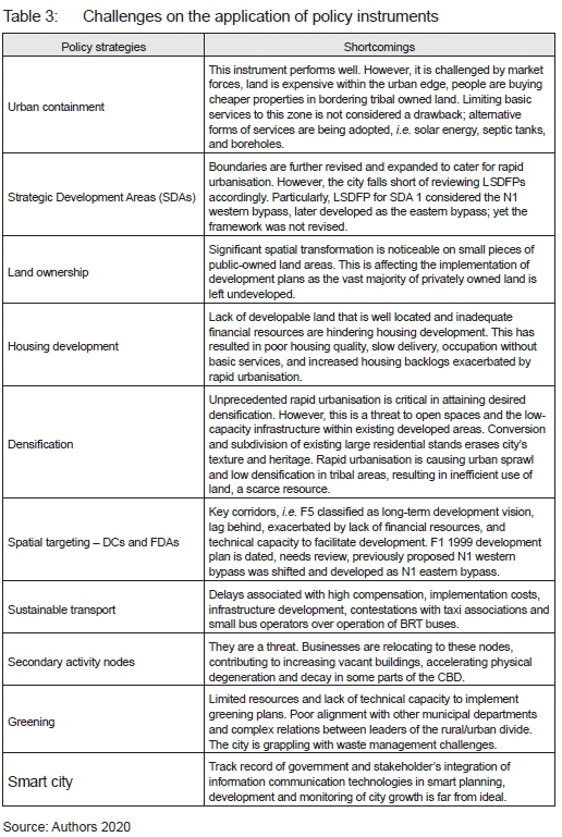
These shortcomings and discourse analysis of the city's local policy frameworks signal policy gaps in Polokwane. There is no comprehensive local spatial development framework for the urban edge; decisions on land-use planning and developments are based on dated LSDFs for SDAs 1 to 3 and SDF established over a decade ago. Most of Polokwane's local policy frameworks were developed, guided by principles and concepts from DFA 67 of 1997 (repealed by SPLUMA 16 of 2013). It is imperative to note the international and national progressive legislative policy shifts over the past decade. This calls for cities to timeously review, amend or draft new policy frameworks to incorporate emerging innovative concepts and principles critical in steering spatial transformation and sustainable development.
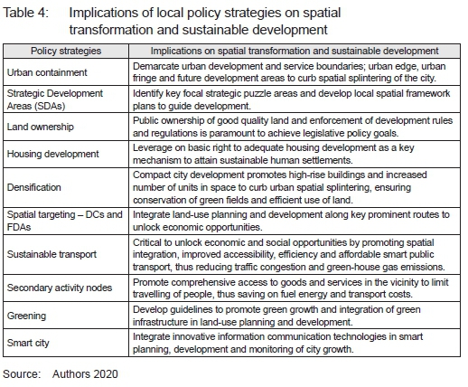
The shortcomings faced by Polokwane are similar to those of the vast majority of small and intermediate cities, namely fiscal challenges, low revenue base, spatial segregation, largely rural worsened by rapid urbanisation, yet they are expected to fulfil their mandate of facilitating spatial transformation and sustainable development. Polokwane provides a learning curve on how similar cities can navigate these issues. It adopted spatial concentration and the selective cluster approach. This facilitates containment and concentration of development in strategic areas to promote the desired spatial transformation and sustainable development (see Table 4).
6. CONCLUSION
The call for the sustainable development of human settlements has long been identified. It is important for all cities (small, intermediate and metros) to share lessons and experiences in respect of their legislative policy directions, experiences and innovations on this journey of sustainable development. This article highlighted how the spatial framework plans can act as a steering mechanism in providing directions for spatial transformation and sustainable development in Polokwane City. The identified sustainable urban form adopted by the city revolves around implementing a robust urban containment strategy in the urban edge. Future development areas are carefully managed to optimise urban densification and mitigate premature suburbanisation fuelled by urban sprawl. This strategy is further aided by the implementation of a raft key policy and action plans incorporating spatial and sustainable development concepts, including strategic development areas, spatial targeting, housing development, densification, sustainable transport, secondary activity nodes-retail centres, and MPCCs, greening and the smart city concept. The spatial transformation and sustainable development planning and policy lessons and insights from Polokwane secondary city provide vital learning possibilities and opportunities on how other intermediate cities can promote sustainable development to mitigate climate change.
7. ACKNOWLEDGMENT
This article is based on a PhD research study titled "Spatial transformation in City of Polokwane, South Africa (1996-2016)".
The financial assistance of the National Research Foundation (NRF) towards this research is hereby acknowledged. Opinions expressed and conclusions arrived at are those of the authors and are not necessarily to be attributed to the NRF.
REFERENCES
ABRAHAMS, G. & MARAIS, L. 2019. Polokwane: A secondary city with a 2030 vision. In: Marais, L. & Nel, V. (Eds). Space and planning in secondary cities: Reflections from South Africa. Bloemfontein: SUN PRESS. [ Links ]
CHAKWIZIRA, J., BIKAM, P. & ADEBOYEJO, T.A. 2018. Restructuring Gauteng city region in South Africa: Is a transportation solution the answer? In: Ergin, Y.B. (Ed.). An overview of urban and regional planning. London, UK: IntechOpen, pp. 83-102. https://doi.org/10.5772/intechopen.80810 [ Links ]
CLOETE, J. & MASSEY, R. 2017. Seshego: An unexpected suburb. South African Geographical Journal, 99(2), pp. 152-165. [ Links ]
CRESWELL, J.W. 2008. Educational research: Planning, conducting, and evaluating quantitative and qualitative research. 3rd edition. Upper Saddle River, NJ: Pearson Education, Inc. [ Links ]
CRESWELL, J.W. & CLARK, V.L.P. 2018. Designing and conducting mixed methods research. 3rd edition. Thousand Oaks, CA: SAGE Publications. [ Links ]
DE VILLIERS, A. & KALEMA, R. 2005. Challenges and opportunities for local government development with reference to the Polokwane Municipality in the Limpopo Province of South Africa. Journal of Public Administration, 40(1), pp. 78-90. [ Links ]
DONALDSON, R. 2005. Intro-/ Retrospection on a provincial capital: Pietersburg/Polokwane revisited. Urban Forum, 16(4), pp. 352-368. https://doi.org/10.1007/s12132-005-0011-2 [ Links ]
DONALDSON. R. & KOTZE, N. 2006. Residential desegregation dynamics in the South African City of Polokwane (Pietersburg). Tijdschrift voor Economische en Sociale Geografie, 97(5), pp. 567-582. https://doi.org/10.1111/j.1467-9663.2006.00364.x [ Links ]
DONALDSON, S.E. 2001. Amalgamation of the former homeland border-township of Seshego and the conservative apartheid city Pietersburg during transition. South African Geographical Journal, 83(3), pp. 208213. https://doi.org/10.1080/03736245.2001.9713738 [ Links ]
DREWES, J.E. & VAN ASWEGEN, M. 2013. National planning in South Africa: A critical review. Sustainable development and planning VI. WIT Transactions on Ecology and The Environment, 173, pp. 193-204. https://doi.org/10.2495/SDP130161 [ Links ]
GORZYM-WILKOWSKI, W.A. 2017. Spatial planning as a tool for sustainable development. Polish realities. Barometr Regionalny. Analizy i Prognozy, 15(2), pp. 75-85. [ Links ]
JABAREEN, Y.R. 2006. Sustainable urban forms: Their typologies, models, and concepts. Journal of Planning Education and Research, 26(1), pp. 38-52. https://doi.org/10.1177/0739456X05285119 [ Links ]
KHAN, K.S., KUNZ, R., KLEIJNEN, J. & ANTES, G. 2003. Five steps to conducting a systematic review. Journal of the Royal Society of Medicine, 96, pp. 118-121. https://doi.org/10.1258/jrsm.96.3.118 [ Links ]
KOTZE, J.N. & DONALDSON, S.E. 1998. Residential desegregation in two South African cities: A comparative study of Bloemfontein and Pietersburg. Urban Studies, 35(3), pp. 467-477. https://doi.org/10.1080/0042098984862 [ Links ]
LATIEF, I., OHGAI, A. & LELEITO, E. 2011. A method of controlling urban growth using incentive and disincentive tax-based cellular automata. Journal of Habitat Engineering, 3(2), pp. 231-242. [ Links ]
LEAVY, P. 2017. Research design: Quantitative, qualitative, mixed methods, arts-based, and community-based participatory research approaches. New York: Guilford Publications. [ Links ]
LEFEBVRE, H. 1991. The production of space. Oxford: Blackwell. [ Links ]
LINDAU, L.A., HIDALGO, D. & FACCHINI, D. 2010. Curitiba, the cradle of bus rapid transit. Built Environment, 36(3), pp. 274-282. https://doi.org/10.2148/benv.36.3.274 [ Links ]
MACKENZIE, N. & KNIPE, S. 2006. Research dilemmas: Paradigms, methods and methodology. Issues in Educational Research, 16(2), pp. 193-205. [ Links ]
MARAIS, L., DU PLESSIS, D., NEL, V. & CLOETE, J. 2019. Secondary cities and spatial transformation in South Africa. In: Marais, L. & Nel, V. (Eds). Space and planning in secondary cities: Reflections from South Africa. Bloemfontein: SUN PRESS. https://doi.org/10.18820/9781928424352 [ Links ]
MILDER, J. 2012. Sustainable urban forms. In: Van Bueren, E., Van Bohemen, H., Itard, L. & Visscher, H. (Eds). Sustainable urban environments. Dordrecht: Springer, pp. 263-284. https://doi.org/10.1007/978-94-007-1294-2_10 [ Links ]
POLOKWANE. 2001. Short study and policy pertaining to the provision of medical and related land uses within the jurisdiction area of Polokwane Municipality: Policy document on land use management. Polokwane: Local Municipality. [ Links ]
POLOKWANE. 2005. Polokwane CBD development plan: Final report November 2005. Polokwane: Local Municipality. [ Links ]
POLOKWANE. 2007a. Framework plan for strategic development area 1. Polokwane: Local Municipality. [ Links ]
POLOKWANE. 2007b. Framework plan for strategic development area 3. Polokwane: Local Municipality. [ Links ]
POLOKWANE. 2008. Feasibility study for the development of business zoning on the southern part of Marshall Street in Polokwane central business district. 1stDraft Report May 2008. Polokwane: Local Municipality. [ Links ]
POLOKWANE. 2009a. Framework plan for strategic development area 2. Polokwane: Local Municipality. [ Links ]
POLOKWANE. 2009b. Polokwane local municipality - Greening plan for hosting the 2010 FIFA World Cup in Polokwane. Polokwane: Local Municipality. [ Links ]
POLOKWANE. 2010. Spatial development framework. Polokwane: Local Municipality [ Links ]
POLOKWANE. 2013a. Comprehensive integrated transport plan Polokwane Local Municipality. Polokwane: Local Municipality. [ Links ]
POLOKWANE. 2013b. Polokwane densification policy for urban areas. Polokwane: Local Municipality. [ Links ]
POLOKWANE. 2013c. Polokwane 2030 economic growth and development plan: Research Report. Polokwane: Local Municipality. [ Links ]
POLOKWANE. 2013d. Polokwane 2030 economic growth and development plan: Development plan. Polokwane: Local Municipality. [ Links ]
POLOKWANE. 2013e. Mankweng framework plan. Polokwane: Local Municipality. [ Links ]
POLOKWANE. 2013f. The State of the City Address of the Executive Mayor of City of Polokwane: CLR Freddy Greaver. Polokwane New Council Chambers, 10 June 2013. Polokwane: Local Municipality. [ Links ]
POLOKWANE. 2014. Operational plan for the implementation of the integrated rapid transit system Polokwane Local Municipality. Polokwane: Local Municipality. [ Links ]
POLOKWANE. 2016. Polokwane integrated development plan 20162021. Polokwane: Local Municipality. [ Links ]
POLOKWANE. 2017a. Polokwane municipal planning by-law. Polokwane: Local Municipality. [ Links ]
POLOKWANE. 2017b. Media release - City of Polokwane launches smart metering. [Online]. Available at: https://www.polokwane.gov.za/SPX%20News%20Article/MEDIA%20RELEASE%20%E2%80%93%20City%20of%20POLOKWANE%20Launches%20Smart%20Metering.aspx [Accessed: 3 June 2020]. [ Links ]
POLOKWANE. 2019. Polokwane integrated development plan 20192020. Polokwane: Local Municipality. [ Links ]
RANTSATSI, N., MUSONDA, I. & AGUMBA, J. 2020. Identifying factors of collaboration critical for improving health and safety performance in construction projects: A systematic literature review. Acta Structilia, 27(2), pp. 120-150. https://doi.org/10.18820/24150487/as27i2.5 [ Links ]
ROSÁRIO, M.D.R. 2016. Curitiba revisited: Five decades of transformation. Architectural Design, 86(3), pp. 112-117. https://doi.org/10.1002/ad.2053 [ Links ]
RSA (REPUBLIC OF SOUTH AFRICA). 1994. Reconstruction and development programme: A policy framework. Pretoria: The Presidency. [ Links ]
RSA (REPUBLIC OF SOUTH AFRICA). 1995. Development facilitation Act, Act 67 of 1995. Pretoria: Government Printers. [ Links ]
RSA (REPUBLIC OF SOUTH AFRICA). 1997. Urban Development Framework. Pretoria: Department of Housing. [ Links ]
RSA (REPUBLIC OF SOUTH AFRICA). 2000. The Local Government: Municipal Systems Act 32 of 2000. Pretoria: The Presidency. [ Links ]
RSA (REPUBLIC OF SOUTH AFRICA). 2003. National Spatial Development Perspective. Pretoria: The Presidency. [ Links ]
RSA (REPUBLIC OF SOUTH AFRICA). 2006. National Spatial Development Perspective. Pretoria: The Presidency. [ Links ]
RSA (REPUBLIC OF SOUTH AFRICA). 2013. Spatial Planning and Land Use Management Act, Act 16 of 2013. Pretoria: Government Printers. [ Links ]
RSA (REPUBLIC OF SOUTH AFRICA). 2019. Draft National Spatial Development Framework. Pretoria: Department of Rural and Land Reform. [ Links ]
RSA (REPUBLIC OF SOUTH AFRICA. DEPARTMENT OF HOUSING). 2004. Breaking new ground: A comprehensive plan for the development of sustainable human settlements. Pretoria: Department of Housing. [ Links ]
RSA (REPUBLIC OF SOUTH AFRICA. NATIONAL PLANNING COMMISSION). 2012. National Development Plan 2030: Our future make it work. Pretoria: The Presidency. [ Links ]
RSA CoGTA (REPUBLIC OF SOUTH AFRICA. DEPARTMENT OF COOPERATIVE GOVERNMENT AND TRADITIONAL AFFAIRS). 2016. Integrated Urban Development Framework: A new deal for South African cities and towns. Pretoria: CoGTA. [ Links ]
RSA DRDLR (REPUBLIC OF SOUTH AFRICA. DEPARTMENT OF RURAL DEVELOPMENT AND LAND REFORM). 2011. Guidelines for the Development of Municipal Spatial Development Frameworks. Pretoria: Department of Rural Development and Land Reform. [ Links ]
SACN (SOUTH AFRICAN CITIES NETWORK). 2017. Spatial transformation: Are intermediate cities different? Johannesburg: South African Cities Network. [ Links ]
SHEN, Z. & KAWAKAMI, M. 2013. Overview: Spatial planning for achieving sustainable urban forms. In: Kawakami, M., Shen, Z., Pai, J., Gao, X. & Zhang, M. (Eds). 2013. Spatial planning and sustainable development: Approaches for achieving sustainable urban form in Asian cities, strategies for sustainability. New York, Springer. DOI 10.1007/978-94-007-5922-0 (eBook). [ Links ]
TEN HAM-BALOYI, W. & JORDAN, P. 2016. Systematic review as a research method in postgraduate nursing education. Health SA Gesondheid, vol. 21, pp. 120-128. https://doi.org/10.4102/hsag.v21i0.942 [ Links ]
THE PRESIDENCY RSA (REPUBLIC OF SOUTH AFRICA). [n.d.]. Twenty-year review South Africa 1994-2014. [Online]. Available at: <https://www.dpme.gov.za/publications/20%20Years%20Review/20%20Year%20Review%20Documents/20%20Year%20Review.pdf> [Accessed: 3 June 2020]. [ Links ]
UN (UNITED NATIONS). 1972. Report of the United Nations Conference on the Human Environment, Stockholm, 5-16 June 1972. A/CONF.48/14/Rev.1. New York: United Nations. https://doi.org/10.5558/tfc48118-3 [ Links ]
UN (UNITED NATIONS). 1976. Report of Habitat: United Nations Conference on the Human Environment (Habitat I) Vancouver, 31 May-11 June 1976. A/ CONF.70/15. New York: United Nations. [ Links ]
UN (UNITED NATIONS). 1987. Report of the World Commission on environment and development: Our common future. "A/42/427 August 1987 English". New York: United Nations General Assembly. [ Links ]
UN (UNITED NATIONS). 1996. Report of the United Nations Conference on Human Settlements (Habitat II), Istanbul (Turkey), 3-14 June 1996. A/CONF. 165/14. New York: United Nations. [ Links ]
UN (UNITED NATIONS). 2015. Transforming our world: The 2030 Agenda for Sustainable Development. A/RES/70/1. New York: United Nations. [ Links ]
UN (UNITED NATIONS). 2016. The United Nations Conference on Housing and Sustainable Urban Development (Habitat III) Quito, Ecuador, 17-20 October 2016. [Online]. Available at: <https://habitat3.org/> [Accessed: 3 June 2020]. [ Links ]
UN (UNITED NATIONS). 2017. New Urban Agenda. A/RES/71/256. United Nations: Habitat III Secretariat. New York: United Nations. [ Links ]
UN (UNITED NATIONS). 2018. Department of Economic and Social Affairs, Population Division. World urbanization prospects: The 2018 revision, custom data acquired via website. [Online]. Available at: <https://population.un.org/wup/DataQuery/> [Accessed: 4 June 2020]. [ Links ]
WEINER, C. 2006. The history of the Pietersburg [Polokwane] Jewish community. Masters dissertation. South Africa: University of South Africa. [ Links ]
Received: June 2020
Peer reviewed and revised: December 2020
Published: June 2021
* The authors declared no conflict of interest for the article or title
1 The English word 'leitmotif' (or 'leitmotiv', as it is also spelled) derives from the German 'Leitmotiv', meaning 'leading motive'.

