


Services on Demand
Article
 English (pdf)
 Article in xml format
 Article references
Indicators

Related links
-
 Cited by Google
 -
 Similars in Google
Share

 Permalink
Town and Regional Planning
On-line version ISSN 2415-0495
Print version ISSN 1012-280X
Town reg. plan. (Online) vol.72 Bloemfontein 2018
http://dx.doi.org/10.18820/2415-0495/trp72i1.1
ARTICLES
http://dx.doi.org/10.18820/2415-0495/trp72i1.1
Communicative mapping as a means for promoting legal land tenure: The case study of the Goedverwacht Moravian Mission Village, in the Western Cape, South Africa
Kommunikatiewe kartering as hulpmiddel om wetlike grondbesit te bevorder: die gevallestudie van die goedverwacht moravian mission village, in die Wes-Kaap, Suid-Afrika
Mmapa wa dipuisano jwalo ka mokgwa wa ho kgothalletsa khiro e molaong ya sebaka: thuto ya mehlala ya goedverwacht moravian mission village, in the Western cape, South Africa
Nicholas Pinfold
Department of Town and Regional Planning, Cape Peninsula University of Technology, Cape Town, South Africa. Phone: 0787823458, e-mail: <pinfoldn@cput.ac.za>
ABSTRACT
The newly enacted Western Cape Land Use Planning Act (Act No. 3 of 2014) repeals the Rural Areas Act (Act No. 9 of 1987) and requires that all land within a municipality be incorporated into an existing municipal zoning scheme. The prospect of this has created uncertainty among the residents of the Goedverwacht Moravian Mission Village (Goedverwacht) in the Western Cape regarding the future of its communal church lifestyle. In anticipation of change, students from the Cape Peninsula University of Technology (CPUT) have embarked on a community mapping service-learning project at Goedverwacht to explore the usefulness of communicative mapping as a means for promoting legal land tenure. This article argues that communicative mapping is a valuable way of creating spatial awareness in a communal settlement. The findings show that creating an interim cadastral map using general boundaries at an accuracy fit for purpose is a feasible way of creating spatial awareness and provides a means for promoting legal land tenure.
Keywords: Communicative mapping, communal tenure, land tenure, land reform, mission towns
ABSTRAK
Die nuwe Wes-Kaapse Grondgebruikbeplanningwet (Wet Nr 3 van 2014) herroep die Wet op Landelike Gebiede (Wet Nr 9 van 1987) en vereis dat alle grond binne 'n munisipaliteit opgeneem word in 'n bestaande munisipale soneringskema. Hierdie vooruitsig het onsekerheid geskep onder die inwoners van die Goedverwacht Moravian Mission Village (Goedverwacht) in die Wes-Kaap aangaande die toekoms van sy gemeenskaplike kerklike lewenstyl. In afwagting van verandering het studente van die Kaapse Skiereiland Universiteit van Tegnologie (CPUT) begin met 'n gemeenskapskaartdiens-leerprojek by Goedverwacht om die nut van kommunikatiewe kartering te ondersoek as 'n middel om wetlike grondbesit te bevorder. Hierdie artikel beweer dat kommunikatiewe kartering 'n waardevolle manier is om ruimtelike bewustheid in 'n gemeenskaplike nedersetting te skep. Die bevindinge toon dat die skep van 'n tussentydse kadastrale kaart met behulp van algemene grense met 'n akkuraatheid vir die doel, 'n haalbare manier is om ruimtelike bewustheid te skep en 'n middel vir die bevordering van wettige grondbesit bied.
Sleutelwoorde: Grondbesit, grondhervorming, kommunikatiewe kartering, kommunale verblyfreg, missiedorpe
TUMELO
Molao o sa tswa etswa wa Western Cape Land Use Act, 2014 (Act No. 3 ya 2014) o phumula/tlosa Rural Act, 1987 (Act No. 9 ya 1987) mme o hloka hore lefatshe lohle hara mmasepala le kenyelletswe hara ditokiso tsa dibaka tsa mmasepala tse seng di le teng. Temoho ya sena e entse tlhokeho ya botsitso bathong ba dulang Goedverwacht Moravian Mission Village (Goedverwacht), Western Cape; mabapi le bokamoso ba tsela ya bophelo ba kopanelo dikerekeng. Tebellong ya phetoho, baithuti ba Cape Peninsula University of Technology (CPUT) ba nkile karolo projekeng therong ya thuto ka ditshebeletso, ho fumana bohlokwa ba mmapa wa dipuisano jwaloka mokgwa wa khiro ya lefatshe e molaong. Atikele ena e hlalosa hore mmapa wa dipuisano ke tsela ya bohlokwa ya ho etsa tlhokomediso ya sepakapaka sebakeng seo batho ba dulang ho sona. Diphumano di bontsha hore ho etsa mmapa wa nakwana wa "cadastral", ho sebediswa dipehelo tse akaretsang, tekanyetsong e nepahetseng bakeng sa morero; ke tsela e ntle ya ho etsa tlhokomediso le ho fana ka tsela ya ho kgothalletsa khiro e molaong ya lefatshe.
1. INTRODUCTION
The newly enacted Western Cape Land Use Planning Act (Act No. 3 of 2014) (LUPA) repeals the Rural Areas Act (Act No. 9 of 1987) (RSA, 1987) and requires that all communal land within a municipality be incorporated into an existing municipal zoning scheme (Western Cape South Africa, 2014: 18). To date, South Africa does not have a legal system for registering an individual's right to land, which is predominantly based on shared use in a community. In order to establish individual rights, the land must be proclaimed as a township, then formally surveyed and subdivided into individual land parcels before being registered in the Deeds Office. This process is costly and time consuming, considering the technical accuracy and the legal processes needed.
Goedverwacht in the Western Cape is a communal mission village and has no demarcated or registered cadastral boundaries; therefore, the spatial framework is fuzzy and confusing. Land tenure reform poses a fundamental dilemma with respect to the future existence of Goedverwacht as a communal mission village.
The objective of the study is to use a fast and economically viable mapping method to identify the way in which land is occupied and used. The map accuracy is determined by purpose rather than by technical and legal requirements needed for registration. A general boundary approach is used to demarcate land parcels, using established visible physical topographies. These cadastral boundaries cannot be registered in the Deeds Register, however, they provide an interim spatial layout of Goedverwacht. The map provides provisional cadastral information that can be incrementally improved over time, in order to achieve a higher level of accuracy when legal needs arise. In so doing, the community of Goedverwacht is able to strengthen its social relationships and prepare for change.
CPUT students from the, Department of Town and Regional Planning have embarked on a service-learning project, using communicative mapping at Goedverwacht. The project forms part of the third-year GIS module curriculum in the Urban and Regional Planning Diploma. The intention is to use geospatial technology (land information systems) to draw a community map in which ordinary people in the community can participate. In so doing, reciprocal learning occurs, empowering both student and resident to mobilise around the issue of land reform. Community participation in the mapping process is intended to create awareness and build social capital among the residents.
2. LAND TENURE IN SOUTH AFRICA
The act of land measurement and land ownership has become part of society and rule of law. Land tenure and secure land title stimulate land markets and encourage investment (Baffour & Hammond, 2013: 56). The precise demarcation of land has been intended to protect people's interests and to prevent illegal occupation of land. The orderly demarcation of land assists governments to manage natural and man-made resources in a sustainable way. Pienaar (2013: 20) refers to the two property administrations that exist alongside one another in South Africa:
• Individualised common-law landownership, co-ownership, and limited real rights that are registrable.
• Communal land tenure, which is predominantly based on the shared use of land by communities in terms of indigenous law principles that are not registrable.
The requirement for the registration of real rights in the South African Deeds Registry is that there must be individualisation of land-use rights for the property. This is not possible in the case of communal land and thus results in a weak permit-based entitlement that is not secure (Pienaar, 2013: 21). Okoth-Ogendo (1989) states that, in indigenous tenure, the right of an individual or group to access land is secure so long as the land is productively used. Therefore, one can consider this access to land as an individual real right under the system. Du Plessis (2011: 63) points out that African indigenous land tenure is unique and that present-day common law 'property and ownership' is not entirely conducive to indigenous land-tenure needs. It is suggested that the commons way of land tenure be considered more closely, as it explains how multiple claim to the same property can be legitimate.
South African legislation has, in accordance with the Constitution, attempted to promulgate laws that facilitate social cohesion within communities by connecting them legally to their land. The Communal Property Associations Act (Act No. 28 of 1996) (CPA) attempts to help community leaders (chiefs) manage land on behalf of a community in terms of a written constitution. It has been found that, in many instances, the constitution for a communal property association is written in a way that excludes some local customs. The chiefs have exerted pressure on the Government to block CPAs, as the communal spirit of tenure is, in many instances, ignored (Van der Westhuizen, 2013).
The Communal Land Rights Act (Act No. 11 of 2004) (CLaRA) (RSA, 2004) was enacted to facilitate the role of local governments in administrating land in communal areas and services to communities on communal land. This Act was found to be unconstitutional and scrapped in 2010 in its entirety by the Constitutional Court (University of Cape Town, 2010). As a result, many South Africans who live in rural communities still do not have security of tenure as guaranteed in the Constitution (Pityana, 2013: 53). The Communal Land Tenure Bill 2017, published on 18 August 2017, aims to address insecurity of land tenure and delivers a legal registration framework of communal land. The Bill makes provision for a land rights enquiry to investigate suitable land tenure options for the community. Thus, the Department of Rural Development and Land Reform will have to appoint a land rights enquirer who consults with members of the community and interested parties (RSA, 2017: 20). Ultimately, a general plan is drawn that designates areas for residential, agricultural, industrial and commercial purposes within the communal land. Following this, the land is registered in the community name or a person who has rights to a subdivided portion of the communal land. The community then decides on a land administration system which could be a traditional council, a communal property association or any other system approved by the Minster responsible for Rural Development and Land Reform. This Bill will demand substantial resources of the Department of Rural Development and Land Reform and the Deeds Registry, which is already under pressure with millions of titles resulting from the Reconstruction and Development Programme housing grants (Beinart, 2017: 9).
3. MAPPING
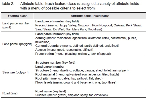
This study uses communicative mapping as a tool to describe the communal village of Goedverwacht. During the project, students from CPUT were asked to explore three different mapping techniques, including participatory, cognitive and community mapping. Each approach has its own purpose; however, when combined, a fit-for-purpose communicative mapping approach is achieved (Table 1). According to Downs and Stea (2011: 312), a physical map is only a theoretical representation of a place. Once the physical space has been mapped, the meaning behind the space needs to be known. A place does not develop in a vacuum; it is the product of the abstract interaction between the physical and cultural identity of people who reside there. Geographical information of a place is only useful if attribute data are identified to indicate the kind of place it is and what characteristic pattern of stimulation is regularly associated therewith (Table 2). According to Glassie (1975: 114), the context of a place is both descriptive (practical) and explanatory (the abstracted context).
The communicative mapping approach does not necessarily meet the technical standards and accuracies provided by a land surveyor for legal registration. A fit-for-purpose approach, in this instance, provides accuracies that are adequately sufficient for the purpose of creating awareness and establishing community advocacy. The general boundaries drawn on the map have been established using topographical features and other indicators without physically beaconing boundary corners. This method of mapping provides a quick and economical way of identifying the spatial layout of the community so that community assets can be documented. The relaxed accuracy has allowed residents to participate in the mapping exercise by sketching and telling where things are rather than by technically mapping them.
In so doing, the focus is on the issues of what makes a place significant rather than on the technical aspect of mapping. The accuracy of the map can be improved incrementally as the need arises.
3.1 Participatory mapping
According to Warner (2015: 1), local knowledge of spaces is essential when defining spatial frameworks. A digitised vector map was presented to the residents of Goedverwacht during the measuring exercise. A participatory approach was adopted where students engaged with residents to improve the accuracy of the information on the map. Participatory mapping is a way of documenting urban change through community participation and engagement. Participatory mapping is not intended to impart technological skills or to share spatial information openly with participants, but to gain a better understanding of community dynamics (Warner, 2015: 4).
3.2 Cognitive mapping
An important part of interpreting spatial structure is through people's cognitive perception. Cognitive mapping is not something newly discovered. When investigating phenomena such as the arrangement of human settlements, one must not overlook the context of what is viewed. A general definition of cognitive mapping is to understand the psychological change in the relative location of features in a spatial environment (Downs & Stea, 2011: 312). A cognitive map is, therefore, not necessarily a spatial map, but a cognitive representation of space. Gribble (1989) suggests that mind awareness is about the nature and formation of environments, rather than a brief insight of space. Liveability is a factor that must be considered when mapping a community. Cognitive mapping allows people to express how they feel about local conditions, the physical attributes that contribute to its ease of use, and how it feels. A local inhabitant has a more accurate and legible cognitive map of the environment than a visitor because clarity is improved with familiarity, memory, and meaning (Lynch, 1960: 1). The type of local economy or agriculture, the built form, and its legacy of prosperity need to be considered so that a collective identity can be determined (Knox & Mayer, 2013:67). During the measuring exercise, students collected attribute data that describe the features on the map. The perceived image of space and environment was also recorded as attribute data (Table 2).
4. COMMUNITY MAPPING
Community mapping, unlike participatory mapping, is intended to allow the community to manage the spatial data themselves and directly influence the final product. Time was taken during the Goedverwacht measuring exercise to allow residents to explain where their boundaries are and sketch topography to describe them. Community mapping minimises conventional measuring practices so that ordinary people can participate. Technology is used in describing space, but people need to define knowledge about their values and vision for the future. Their views matter, especially those of the poor and marginalised. Unanticipated connections that occur during community mapping benefit the process (Lydon, 2007: 1).
5. LAND INFORMATION SYSTEM
A land information system is a way of documenting geographic data and administering land. It is important to rethink institutional arrangements on how people's rights to land and resources are recorded (Kalantari, Rajabifard, Wallace & Williamson, 2006: 3). When a land information system is used to administer land, it is important that the information be easily accessible and up-to-date (Kurwakumire, 2014: 66). Du Plessis (2011: 53) suggests that a land information system could be a useful way of documenting multiple use of land for different purposes over different periods of time. This would allow the documenting of multiple ownership of the same piece of land. Furthermore, this is a suitable way of recording the various interests in land with time frames (Enemark, McLaren & Lemmen, 2015: 34). Such a system is conducive to documenting land in communal areas and could be considered parallel to the Deeds Registry system.
6. THE CASE OF THE GOEDVERWACHT MORAVIAN MISSION VILLAGE
The case study of Goedverwacht Moravian Mission Village is presented in an attempt to illustrate how communicative mapping could create awareness and build social capital among the residents through community participation. The findings in this case study emanated from a student service-learning project, using communicative mapping at Goedverwacht.
6.1 Study area
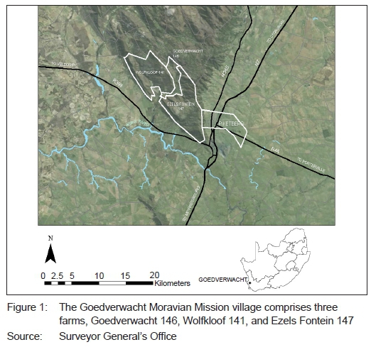
Goedverwacht is situated in the Bergrivier Municipality in the Western Cape, 25km west of Piketberg, located on private land, within a predominantly agricultural area (Figure 1). The farm is owned by the Moravian Church of South Africa and is held in trust by the Minister of Land Affairs for the benefit of the residents under the Rural Areas Act (Act No. 9 of 1987). As a result, the Goedverwacht community has not been bound by any spatial planning act or land use ordinance in the past and, therefore, has had limited state assistance with planned development. These circumstances have resulted in the village growing and developing informally along the Platkloof River (Bergrivier Municipality, 2015: 173). Residents of Goedverwacht are able to own houses in the village, but cannot obtain legal tenure of their properties. In the past, mission villages in South Africa were mainly established to provide a place for the marginalised in society, rather than to serve religious, administrative, and commercial needs. The farm Goedverwacht was first established in 1819 and was bought by the Moravian Church in 1888. Goedverwacht was slow to develop, due to the uncertainty of its inhabitants' property rights, and only achieved formal status in 1889 (Fransen, 2006: 138). Goedverwacht initially accommodated approximately 200 inhabitants; however, the town has now increased to approximately 1 979 inhabitants, according to the 2011 census (Bergrivier Municipality, 2015: 171). Goedverwacht has been administered as a private village on private land and is presently managed and run by the Overseers Board (Opsienersraad) members associated with the Moravian Church headquarters in Cape Town (Bergrivier Municipality, 2015: 171). The village sprawls in a linear development that extends for approximately 3.8km along the river. The main land use is low-density residential with subdivided agricultural land in the Platkloof River floodplain (Figure 3). Permaculture is customary in the village, with vegetable crops planted around village dwellings. Some gardens sprawl without definition, merging and mingling with neighbouring gardens, while other boundaries are well defined. Some properties sprawl across the veld to areas where animal pens and chickens are kept.
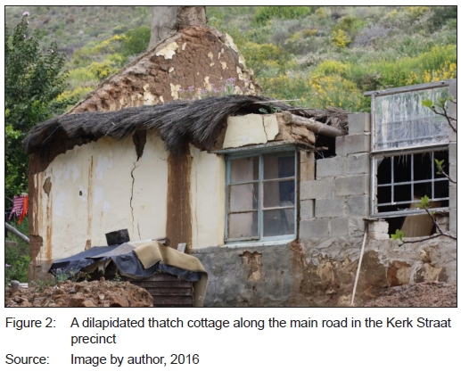
Although residents do not have secure legal land tenure to their properties, they do have long-term guarantee of rights to the use of the property on the farm. Nevertheless, without legal tenure, some residents have hardly any incentive to invest in property improvements. This is particularly problematic for properties along the main road that have heritage status (Figure 2). Furthermore, residents who grow vegetables in the agricultural allotments at Goedverwacht are unlikely to invest in irrigation equipment and other systems without a secure entitlement system.
The issue of land reform at Goedverwacht is not new. On 22 October 1996, the Genadendal Accord was signed between the South African Government and the Moravian Church, committing both State and Church to work towards land reform and development (Ntsebeza, 2005: 62). On 5 July 1998, the Moravian Church adopted the Genadendal Accord as part of its constitution and endorsed the coordinating committee with the Department of Land Affairs and the Legal Resource Centre (Ntsebeza, 2005: 65). A policy position was formulated by the Department of Land Affairs and approved by the Minister on 20 March 2000 regarding church land. This document did not seek to make new policy; it was intended to show how existing policy can be adapted to facilitate land reform on church land (Ntsebeza, 2005: 63).
6.2 Research approach
The Goedverwacht community engagement service-learning project was initiated with the signing of an agreement between the Goedverwacht leadership and CPUT committing to a partnership that aims to assist the Goedverwacht community in achieving a community-owned and -driven development processes. The partnership aims to ensure a holistic and collaborative approach that will, at all times, encourage community participation wherever possible and keep, as its central focus, that the residents of Goedverwacht be the determinants of their own development agenda.
The method used to implement academic-based community engagement is through the pedagogy of service learning. Service-learning is a relatively new pedagogy that provides a framework for partnershipbuilding between universities and society and stimulates civic engagement (Thomson, Smith-Tolken, Naidoo & Bringle, 2011: 220). It is said that service-learning contextualises and provides new insights into knowledge production and provides a pedagogical intervention that gives students an opportunity to educate themselves in society's problems and gain knowledge of community issues first-hand (Bringle & Steinberg, 2010: 429). According to Bringle et al. (2004: 6, cited in Bender, Daniels, Lazarus, Naude & Sattar, 2006: 25), service-learning provides a means for students to relate academic content to practice. Unlike volunteer community service, which is associated with charity work, service-learning is connected to academic content that permits formal academic learning (Thomson et al., 2011: 224). It is important that reciprocal learning happens where student and community learning takes place. It is the intention that community activities at Goedverwacht be done with rather than for the community. Community engagement at higher education institutions focuses on gaining and transferring knowledge rather than providing a free service. Furthermore, community engagement creates social interaction among residents and stakeholders. One of the primary factors in developing sustainable communities is increasing social capital, in order to address the needs of the community more efficiently (Bridger & Luloff, 2001: 459; Dale & Newman, 2010: 227).
6.3 Survey method
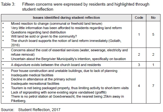
An ethnographic approach was taken where students became active participants in observing community space, place and environment (Mouton, 2008: 149). Students spent time in each of the nine neighbourhoods, in order to get a sense of place as well as a holistic view of the village. The significance of space was described, using vector graphics. Students were required to keep a reflective diary and record conversations with residents concerning the development of the community. Gaining trust and establishing rapport with the residents was an important first step. During the measuring exercise, unstructured discussions took place with residents, while students measured building footprints and used Global Positioning System (GPS) to obtain coordinate of corner points. This provided an opportunity for students to explain what they were doing and, in return, ask questions about community dynamics. Students were asked to document their observations to ensure trustworthiness of data and provide an audit trail of evidence. Students completed a reflection questionnaire in the classroom and attended reflective sessions where community concerns were identified. Grounded theory analysis was used to table notable concerns expressed by the residents during student reflection sessions (Table 4).
6.4 Mapping process
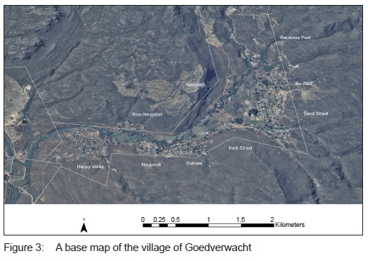
During the planning phase, a base map of the village was digitised from topographical features using satellite imagery. Pleiades ortho-rectified high-resolution satellite imagery was used at a location accuracy of approximately 1.5m. Secondary spatial data was obtained from Government Department archives and included on the base map. This phase was completed in the laboratory with no input from residents or community stakeholders (Figure 3).
Figure 3 shows the initial map of Goedverwacht which was digitised by CPUT students from satellite imagery. There are nine distinct precincts defining Goedverwacht Happy Valley, Noupoort, Oukraal, Kerk Straat, Sand Straat, Bo-Werf, Ramblers Park, Rooidraai, and Rooi-Noupoort.
Each week, a group of twelve students was taken to Goedverwacht to spend a day in the village with the community (Figure 4). The students did various mapping tasks. The first task was to measure and map building footprints, using Mobile Geographic Information System (GIS) and a Global Positioning System (GPS) technology. During this task, dialogue was initiated between the resident and the student by making use of communicative mapping. The second task was to collect attribute data for each feature on the map (Table 2). Some of the attribute data captured was image provoking with the intention of visualising 'a sense of place' (Figure 5). A DJI drone quad-copter aircraft was used to photograph the village from approximately 100m above ground level. The aerial photographs were used to assist in determining the general boundaries by identifying fences, hedges, walls, rivers and other distinct boundary markings (Figure 5).
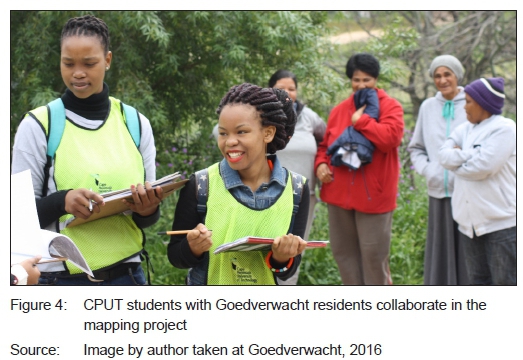
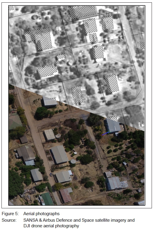
Figure 5 shows a comparison of satellite imagery at the top, aerial photography imagery at the bottom, and ground survey methods (hatched buildings). The hatched buildings were measured and positioned by students, using a tape measure and GPS coordinates.
Reflective sessions were arranged with students prior to, during and after site visits. The purpose of the first reflection was for the student to describe the place based on the map drawn in the laboratory. The second session revealed the student's curiosity during engagement, and the third interrogated the community dynamics as perceived by the students.
All geographic information obtained at Goedverwacht has been captured in a geo-database that simulates a land-information system. ArcGIS software consists of an object-oriented geo-database that is able to accommodate various geographic datasets in different layers held in a common filing system. It is driven by a database management system (DBMS) or file system that allows simple data access and maintenance. Furthermore, it is possible to access datasets through other database management systems, using the standard query language (SQL). Overlapping fuzzy boundaries and dual ownership of land are accommodated in this system. This simple GIS demonstrates the effectiveness of documenting boundaries in a land-information system.
Crowdsourcing will continue to improve the map. Crowdsourcing involves outsourcing the mapping task to the Goedverwacht community of residents (Nguyen, Tahmasbi, De Vreede, De Vreede, Oh & Reiter-Palmon, 2016: 283). In this phase, the community takes ownership of the map and adds information. Once adjustments have been made to the map, further surveys are expected at Goedverwacht to establish the sentiment of the residents concerning land reform.
6.5 Spatial analysis using attribute data collected
The geographic information obtained during the mapping project was used to visualise certain spatial occurrences that describe the community. A map was drawn to indicate land usage (Figure 6).
Figure 6 shows that general boundaries were established, using visible (physical) topographies. These cadastral boundaries that cannot be registered in the Deeds Office provide an interim spatial layout of Goedverwacht. The interim spatial layout is an economically viable way of rapidly acquiring spatial informaon at an accuracy determined by the purpose rather than technical standards.
Goedverwacht is characterised by buildings that are under construction. Many buildings have remained under construction for at least three years without much change. Other buildings have deteriorated to such an extent that they have become ruins. A hotspot analysis was done, using Getis-Ord GI statistics to visualise the areas where significant building construction is taking place (Figure 7).
Figure 7 shows a hotspot analysis of building activities that indicate statistically significant clusters of areas where building construction is under way, partially complete, or complete.
From this analysis, it is evident that significant construction is taking place in the Happy Valley neighbourhood; this is consistent with it being the newest neighbourhood located at the west entrance of Goedverwacht. On the other hand, Kerk Straat is the oldest precinct and most settled in terms of building construction.
Student impressions of the village were analysed. Land parcels were colour coded according to the attributes collected. The purpose of the analysis was to visualise student's view of 'a sense of place' (Figure 8).
Students were asked to express their opinion regarding the appeal of each property. If the property had well-maintained buildings, tidy gardens and vividness, students recorded the property as 'Pleasing'. If students felt impartial, they recorded it as 'Ordinary', and if students thought the property lacked most of these qualities, they recorded it as 'Lack of appeal'. The purpose of this analysis is to visualise 'a sense of place' as perceived from an outsider's point of view.
7. FINDINGS
The data collected during this research comprises spatial and non-spatial mapping data and qualitative descriptive data that highlight residents' concerns regarding development. The spatial and non-spatial mapping data consists of raster, vector and feature attributes. A GIS object-oriented database was used to capture the data. The type of geographic analysis of the data depends on what scientific or decision-making problem needs to be solved. Students were required to use the spatial data to demonstrate their understanding of spatial analyses, as required by the GIS300S curriculum. A GI statistical hotspot analysis was done to visualise areas in Goedverwacht that have a significant amount of building construction taking place.
Secondly, a unique value symbolic analysis was done by colour coding each property according to the attributes collected, in order to visualise the students' perceptions of the environment.
• The general boundary approach is a fast and effective way
of defining land parcels that can be used to geo-reference community assets.
• Residential property boundaries are sometimes fuzzy and need to be clearly defined by residents. The community mapping approach allows residents
to sketch or say where their boundaries are. Furthermore, residents' cognitive awareness of space was taken into account during conversation.
• High-resolution satellite imagery is useful for feature identification and settlement classification, but is not sufficiently clear for identifying shapes of structures and topographical features such as fences, hedges and walls. Large-scale aerial photography provides better clarity for this purpose.
• Drone imagery taken 100m above ground level is a fast and cost-effective way of obtaining aerial photography. Ground control points coordinated at sub metre accuracy are needed to geographically transform aerial photography in GIS. Care must be taken to minimise scale distortion when using non-rectified aerial photography.
• Mobile GIS/GPS is an effective tool for collecting attribute data and geo-referencing building corners. GPS readings must be differentially corrected to achieve a sub metre accuracy. Building footprints were measured
to establish the perimeter dimensions. Coordinated building corners can be used as ground control points to geographically transform aerial photography in GIS.
• Map accuracy varies considerably depending on the mapping process. Metadata are essential for documenting the mapping process, technique and accuracy of data acquired.
The qualitative descriptive data collected by students during the measuring exercise reveals some of the residents' concerns regarding development at Goedverwacht. The inquiry was interpreted based on the grounded theory methodology. During reflection sessions, students revealed fifteen concerns residents have as recorded in their field diaries. The fifteen concerns were coded into four categories: Code: 1 - land reform; 2 - integration with the Bergrivier Municipality; 3 - community dynamics, and 4 - infrastructure and services (see Table 3).
The leadership of Goedverwacht has agreed to implement a quantitative survey, using a structured questionnaire to inquire about residents' views and aspirations regarding land reform. Concerns identified by students during this research will be considered when designing the structured questionnaire. CPUT students have been invited back to assist with the survey.
8. CONCLUSION
The Communal Land Tenure Bill 2017 aims to address insecurity of land tenure in communal areas. Once enacted, the process will require the services of a 'land-use enquirer' who will consult with the community and other interested stakeholders to determine the future of land administration in the area. The adaptive capacity of the community will depend on how prepared residents are for change. This research advocates that a key way to prepare the community for change is to implement communicative mapping.
Students from CPUT embarked on a service-learning project to assist residents with communicative mapping and thereby applied knowledge and technical skills learnt in the classroom in a community setting. During reflection sessions, students spoke out about community concerns. Grounded theory analysis was used to itemise and code these concerns. Students produced a cadastral map based on general boundaries. The purpose of the map was to create spatial awareness and to promote discussion among residents regarding land reform. The three mapping techniques used, namely participatory, cognitive and community mapping, ensured a community-led approach and encouraged advocacy among residents. Attribute data describing features on the map were captured and documented in a land-information system. Additional attribute data will be added to the land-information system and map accuracies improved through crowd sourcing. In the case of the Goedverwacht Moravian Mission Village, it is evident that communicative mapping advocates awareness and has been effective in preparing the community for change.
REFERENCES
BAFFOUR, A. & HAMMOND, F. 2013. Prognosis of land title formalization in urban Ghana: The myth and reality of awareness and relevance. African Studies Quarterly, 14(1 & 2), pp. 55-75. [ Links ]
BEINART, W. 2017. Comments on the Communal Land Tenure Bill, 2017. African Studies Centre, University of Oxford, posted on 11 August 2017. [Online]. Available at: <https://www.gga.org/communal-land-tenure-bill-2017/>. [Accessed: 12 November 2017]. [ Links ]
BENDER, G., DANIELS, P., LAZARUS, J., NAUDE, L. & SATTAR, K. 2006. Service-learning in the curriculum. A resource for higher education institutions. Pretoria: The Council on Higher Education. [ Links ]
BERGRIVIER MUNICIPALITY 2015. Spatial Development Framework: 20122017, Volume I. [ Links ]
BRIDGER, J. & LULOFF, A. 2001. Building the sustainable community: Is social capital the answer? Sociological Inquiry, 71(4), pp. 458-472. https://doi.org/10.1111/j.1475-682X.2001.tb01127.x [ Links ]
BRINGLE, R. & STEINBERG, K. 2010. Educating for informed community involvement. The American Journal of Community Psychology, 46(3-4), pp. 428-441. https://doi.org/10.1007/s10464-010-9340-y [ Links ]
DALE, A. & NEWMAN, L. 2010. Community vitality: The role of community-level resilience adaptation and innovation in sustainable development. Sustainability, 2(1), pp. 215-231. https://doi.org/10.3390/su2010215 [ Links ]
DOWNS, M. & STEA, D. 2011. The map reader: Cognitive maps and spatial behaviour: Process and products. In: Dodge, M., Kitchin, R. & Perkins C. (Eds). Theories of mapping practice and cartographic representation. West Sussex: John Wiley & Sons, pp. 312-317. https://doi.org/10.1002/9780470979587.ch41 [ Links ]
DU PLESSIS, W. 2011. African indigenous land rights in a private ownership paradigm. Potchefstroom Electronic Law Journal/ Potchefstroomse Elektroniese Regsblad, (14)7, pp. 49-65. [ Links ]
ENEMARK, S., MCLAREN, R. & LEMMEN, C. 2015. Fit-for-purpose land administration guiding principles. Nairobi, Kenya: Global Land Tool Network, UN-Habitat & Kadaster. [Online]. Available at: <https://www.scribd.com/doc/293851814/Fit-For-Purpose-Land-Administration-Guiding-Principles> [Accessed: 30 April 2017]. [ Links ]
FRANSEN, H. 2006. Old towns and villages of the Cape. Johannesburg: Jonathan Ball. [ Links ]
GLASSIE, H. 1975. Folk housing in Middle Virginia. Knoxville, Tennessee: University of Tennessee Press. [ Links ]
GOLIATH, C. 2016. (Reverend of the Goedverwacht Moravian Church) Interview on Goedverwacht community. Goedverwacht, 29 September. [ Links ]
GRIBBLE, J. 1989. Verlorenvlei vernacular: A structuralist analysis of Sandveld folk architecture. Unpublished M. Thesis, University of Cape Town. [ Links ]
KALANTARI, M., RAJABIFARD, A., WALLACE, J. & WILLIAMSON, I. 2006. A new vision on cadastral data model. Shaping the Change, XXIII FIG Congress, 8-13 October, Munich, Germany. [ Links ]
KNOX, P. & MAYER, H. 2013. Small town sustainability: Economic, social, and environmental innovation. Berlin: Walter de Gruyter. [ Links ]
KURWAKUMIRE, E. 2014. Digital cadastres facilitating land information management. South African Journal of Geomatics, 3(1), pp. 64-77. [ Links ]
LYDON, M. 2007. Mapping our common ground: A community and green mapping resource guide. Common Ground. [ Links ]
LYNCH, K. 1960. The image of the city. Cambridge: MIT Press. [ Links ]
MOUTON, J. 2008. How to succeed in your master's and doctoral studies: A South African guide and resource book. Pretoria: Van Schaik. [ Links ]
NGUYEN, C., TAHMASBI, N., DE VREEDE, T., DE VREEDE, G.J., OH, O. & REITER-PALMON, R. 2016. A definition of community crowdsourcing engagement and application. In: D'Ascenzo, F., Magni, M., Lazazzara, A. & Za, S. (Eds). Blurring the boundaries through digital innovation. Basel: Springer International Publishing, pp. 283-296. https://doi.org/10.1007/978-3-319-38974-5_22 [ Links ]
NTSEBEZA, L. 2005. Land tenure reform in South Africa: A focus on the Moravian Church land in the Western Cape. In: Evers, S., Spierenburg, M. & Wels, H. (Eds). Competing jurisdictions, setting land claims in Africa. Leiden: Koninklijke Brill. [ Links ]
OKOTH-OGENDO, H. 1989. Some issues of theory in the study of tenure relations in African agriculture. Access, Control and Use of Resources in African Agriculture, 59(1), pp. 6-17. [ Links ]
PIENAAR, G. 2013. Land tenure security: The need for reliable land information. The Journal of the Helen Suzman Foundation, 70, pp. 20-27. [ Links ]
PITYANA, S. 2013. The constitution, citizenship and redress. The Journal of the Helen Suzman Foundation, 70, pp. 48-53. [ Links ]
RSA (REPUBLIC OF SOUTH AFRICA). 1987. Rural Areas Act (House of Representatives), Act 9 of 1987. Pretoria: Government Printer. [ Links ]
RSA (REPUBLIC OF SOUTH AFRICA). 2004. Communal Land Rights Act, Act 11 of 2004. Pretoria: Government Printer. [ Links ]
RSA (REPUBLIC OF SOUTH AFRICA). 2017. Communal Land Tenure Bill. Pretoria: Government Printer. [ Links ]
STUDENT REFLECTIONS. 2017. Unpublished student reflections. GIS300S 2017. Urban and Regional Planning, Cape Peninsula University of Technology, South Africa. [ Links ]
STUDENT REPORTS. 2017. Unpublished student reports. GIS300S 2017. Urban and Regional Planning, Cape Peninsula University of Technology, South Africa. [ Links ]
THOMSON, A., SMITH-TOLKEN, A., NAIDOO, T. & BRINGLE, R. 2011. Service-learning and community engagement: A comparison of three national contexts. Voluntas, 22(2), pp. 214-237. doi:10.1007/s11266-010-9133-9. https://doi.org/10.1007/s11266-010-9133-9 [ Links ]
UNIVERSITY OF CAPE TOWN. 2010. Press statement on the Constitutional Court judgement on the Communal Land Rights Act. [Online]. Available at: <https://open.uct.ac.za/bitstream/item/2219/CLS_Press_Release_ CLRA_11052010.pdf?sequence=1> [Accessed: 19 October 2016]. [ Links ]
VAN DER WESTHUIZEN, C. 2013. Rural people remain in limbo waiting for CLaRA's replacement. Land and Accountability Centre, University of Cape Town. [Online]. Available at: <http://www.customcontested.co.za/rural-people-remain-in-limbo-waiting-for-claras-replacement/> [Accessed: 19 October 2016]. [ Links ]
WARNER, C. 2015. Participatory mapping: A literature review of community-based research and participatory planning. Cambridge, Massachusetts: Massachusetts Institute of Technology, Social Hub for Community and Housing, Faculty of Architecture and Town Planning, pp. 1-20. [ Links ]
WESTERN CAPE, SOUTH AFRICA. 2014. Western Cape Land Use Planning Act, Act 3 of 2014. Pretoria: Government Printer. [ Links ]
Reviewed January 2018
Revised January 2018
The author declared no conflict of interest for this title or article.

