


Services on Demand
Article
 English (pdf)
 Article in xml format
 Article references
Indicators

Related links
-
 Cited by Google
 -
 Similars in Google
Share

 Permalink
Clean Air Journal
On-line version ISSN 2410-972X
Print version ISSN 1017-1703
Clean Air J. vol.32 n.2 Pretoria 2022
http://dx.doi.org/10.17159/caj/2022/32/2.12145
RESEARCH ARTICLE
The use of fire radiative power observations to determine spontaneous combustion event activities associated with coal mining on the Mpumalanga Highveld
Edwin CoghoI; Johan P. BeukesI; Pieter G. van ZylI; Ville VakkariI, II
IAtmospheric Chemistry Research Group, Chemical Resource Beneficiation, North-West University, Potchefstroom, South Africa
IIFinnish Meteorological Institute, Helsinki, Finland
ABSTRACT
Coal mining is a significant activity on the Mpumalanga Highveld. One of the major air pollution issues associated with coal mining, is the spontaneous combustion of coal. There are no abatement technologies in place for such emissions, and typically long- and shortlived greenhouse gases, other gaseous pollutants and particulate matter are emitted by such events. For ambient air quality models to accurately capture the contribution of spontaneously combusted coal, it is necessary to determine the locations and durations of these burning events. Such information will also assist in explaining experimentally determined ambient air quality data. In this article, satellite fire radiative power (FRP) data from the Moderate Resolution Imaging Spectro-Radiometer (MODIS) was used to determine the locations and durations of spontaneously combusted coal within the Mpumalanga Highveld for January 2001 to December 2019. From the results it was concluded that five mining sites were prone to spontaneous combustion. These sites were all opencast mines situated on old bord and pillar mines. Two of these areas were actively burning for most of the 19-year study period. A relatively well-defined seasonal pattern was also observed, with combustion events being more prevalent during the winter months. Considering the active burning periods of the areas where spontaneous combustion were recorded, it is obvious that this is a major source of atmospheric pollutants on the Mpumalanga Highveld.
Keywords: Spontaneous coal combustion, coal mining, MODIS, fire radiative power
Introduction
Spontaneous combustion of coal is prevalent in the coal mining industry and happens as coal is exposed to oxygen (Pone et al. 2007). This phenomenon is of global concern as these burning events contribute to global warming, the degradation of air quality and pose other significant environmental problems (Pone et al. 2007). Many of the same pollutants are emitted by the spontaneous combustion of coal, as from coal-fired power plants (Sloss 2013). However, because there are no abatement technologies in place for these events, the emission factors are in general higher (Sloss, 2013). Greenhouse gases (GHG's) such as carbon dioxide (CO2) and methane (CH4), equivalent black carbon (eBC, definition according to Petzold et al., 2013) and other atmospheric pollutants like particulate matter (PM), carbon monoxide (CO), mercury, oxides of nitrogen (NOx), oxides of sulphur (SOx), hydrogen sulphide (H2S) and volatile organic compounds (VOC's) are typically emitted by spontaneous combustion of coal (Stracher and Taylor 2004; Pone et al. 2007; Carras et al. 2009; Zhen-qi et al. 2009; Sloss 2013).
In South Africa, a significant fraction of coal mining activities take place in the Mpumalanga Highveld. Coal mining activities typically include open-cast mines, coal refuse disposal areas and open-cast mining operations above old bord and pillar mining operations. The latter being known for spontaneous combustion of coal as old bord and pillar workings are re-mined and exposed to oxygen (Bell et al. 2001; Pone et al. 2007).
Considering the aforementioned, it is of utmost importance to determine where spontaneous combustion of coal is taking place, for how long these activities take place and to estimate the contribution of these burning emissions on air quality.
However, doing this is problematic as many of these combustion events occur in remote areas and some even go by unnoticed. Thus, in this article the fire radiative power (FRP) data obtained from the Moderate Resolution Imaging Spectroradiometer (MODIS) onboard the Terra and Aqua satellites (Kaufman et al. 1998; Justice et al. 2002) were used to determine the location and number of burning events from January 2001 to December 2019 within the Mpumalanga Highveld region. A similar method was used by Beukes et al. (2018) to identify and determine the activities of pyro-metallurgical smelters within South Africa. In Figure 1 the region in South Africa, more specifically the Mpumalanga Highveld, under investigation is presented with a Google Earth map. Within this area, the locations of open-cast coal mining operations, as well as mine refuse dumps, were derived from rigorous visual inspection of Google Earth images and are presented in the Google Earth map.
Method
Identification of spontaneous coal combustion
FRP data was obtained from the MODIS instruments aboard the Terra and Aqua satellites for the period of January 2001 to December 2019 (Kaufman et al. 1998; Justice et al. 2002). The MODIS collection 6 FRP data was downloaded from the Fire Information for Resource Management System archives (https://firms.modaps.eosdis.nasa.gov/download/). MODIS FRP data (MOD14A1/MYD14A1) indicate the locations of fires with substantial thermal emissions at times when the satellites pass over the area. These thermal emissions are usually from open biomass burning events (grassland, savannah and forest fires), but certain point sources with substantial thermal emissions (e.g. metal/slag tapping or off-gas flaring from pyrometallurgical smelters) are also detected as thermal anomalies (Beukes et al. 2018). Considering the thermal emissions from spontaneous coal combustion, these burning events could also be captured in the FRP data, depending on the fire size (m2) and temperature (°C). MODIS easily detects smouldering and flaming landscape fires of a 1000 m2 in size. However, if conditions are favourable, fires as small as 50 m2 can be detected. On the other hand, false alarms are possible, but rare especially for southern Africa (Giglio et al., 2016). In our application, where we are looking for sites with continuous combustion for weeks or more, occasional false positive FRP observations are not an issue. Giglio et al. (2003) discusses the probability of detection in further detail.
In Figure 2 an example of the FRP data is depicted, with red dots indicating fires recorded for February and March 2016. Each red dot represents a burning activity recorded in a 1 km2 cell. A Google Earth image of the encircled area indicated in Figure 2 is also presented. Numerous detected fires can be seen in Figure 2, as well as thermal anomalies at industrial facilities. Within the encircled area in Figure 2, 6 pixels (at 1 km resolution) indicate continuous combustion for two consecutive months and 3 more pixels indicate combustion part of the time. It is obviously impossible for the same vegetation to be actively burning constantly for months on end, as the fuel required for combustion will mostly be consumed after one burning event. Additionally, the timing of the fires (i.e., in February and March) does not coincide with the South African interior's open biomass burning season. The green polygon seen in the Google Earth image in Figure 2, which is located within the encircled area indicates the location of an open-cast coal mine. Considering the timing (within the rainy season), reoccurring nature of the fires and that there are no clear visible signs of burnt vegetation, it is evident that the coal combustion is responsible for the observed FRP.
To investigate if there was active burning at coal mining sites, circles with radii between 1-5 km (depending on size of mining activity, determined by the above ground visible mined area) were drawn around the coordinates of each of the mining locations indicated Figure 1 and the monthly fire counts within these polygons were tallied. If reoccurring fires for consecutive months were observed, such a site was classified as having had actively burning coal.
Hysplit dispersion model
A Hybrid Single-Particle Langrangian Integrated Trajectory (HYSPLIT) dispersion calculation (Stein et al. 2015; Rolph et al. 2017) was used in the case study presented in section 3.2. The model was run on the interactive web system available at the Air Resources Laboratory website (https://www.ready.noaa.gov/index.php). The model uses particle or puff approaches to compute dispersion, trajectories or deposition. Dispersion calculations requires meteorological data as input, which can be obtained through ARL and the Global Data Assimilation System (GDAS1) meteorological dataset was used for the HYSPLIT dispersion calculation in this article.
Elandsfontein atmospheric monitoring station
The Elandsfontein atmospheric measurement station is located on a hilltop at the following coordinates 26° 14'43 S, 29° 25'30 E, 1750 MAMSL in the Mpumalanga Highveld. The surrounding environment of the Elandsfontein site is mainly grazed grassland (Mucina and Rutherford, 2006 and cultivated. No large point sources occur within a 15 km radius of the station. However, within a 100 km radius, several coal-fired power stations, pyrometallurgical smelters and a large petrochemical operation are situated (Collett et al., 2010; Laakso et al., 2012).
H2S, ozone (O3), nitrogen oxides (NOx) and SO2 were measured using a Thermo Electron 43A with a Thermo Electron 340 converter, a Monitor Europe ML9810B O3 analyser, Thermo Electron 42i NOx analyser and a Thermo Electron 43C SO2 analyser, respectively. Equivalent black carbon (eBC) (definitions according to Petzold et al., 2013) was measured with a Thermo Scientific model 5012 multi-angle absorption photometer (MAAP), for which eBC concentrations were corrected according to the algorithm presented by Hyvärinen et al. (2013). In addition to the above, many other measurements were taken at the Elandsfontein station, but these measurements were not used in this paper and are therefore not discussed.
Results and discussion
Spontaneous combustion activities
Five sites recorded long-lasting and reoccurring anomalous thermal values in the FRP time series, indicating significant spontaneous combustion events. However, it is possible that sites, where combustion occurs at smaller quantities and FRP remains below MODIS detection limit could be missed. On the other hand, emissions scale with FRP (e.g. Sofiev et al., 2009) and so we consider the five sites identified here as the most important ones from air quality perspective. The locations of these sites are presented in Figure 3. All of these mines are opencast mines, which are situated above old bord and pillar mines from the 1900's. Once the roof of these underground board and pillars are opened, an influx of oxygen can cause the old unmined coal pillars to spontaneously combust (Bell et al. 2001; Pone et al. 2007).

The algorithm developed by Beukes et al. (2018) was applied to the repetitive fires to establish when the sites were actively burning. 3-Month moving averages of the fire pixels were calculated for each of the sites, which was then divided by the 75th percentile for that specific site (Beukes et al. 2018). These values were converted to percentages and grouped into five ranges as follows (Beukes et al. 2018):
1. Percentages < 10% represented zero calculated spontaneous combustion
2. 10% > percentages < 25% represented 10 to 25% of the time considered as having spontaneous combustion
3. 25% > percentages < 50% represented 25 to 50% of the time considered as having spontaneous combustion
4. 50% > percentages < 75% represented 50 to 75% of the time considered as having spontaneous combustion
5. 75% > percentages < 100% represented 75 to 100% of the time considered as having spontaneous combustion.
The aim of considering percentage ranges of the considered time, instead of absolute percentage values is to minimize the effect of missing observations due to e.g. cloud cover over the area.
In Figure 4 the calculated percentage spontaneous combustion ranges for the five mining locations are presented. It is evident from the figure that spontaneous combustion at these 5 sites were prevalent throughout the 19-year period with locations A and B being the most active. Burning at locations A and B continued for several consecutive months, over many years. From this figure a possible season cycle also becomes evident, but this (the season cycle) will be considered in greater detail later.
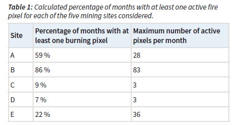
In Table 1 the percentage of months with at least one active fire pixel is presented for each of the five mining sites considered. Site B was by far the most active, as on 86 % of all months there was at least one active fire within the area defined for this specific site, over the 19-year period. Site A had the second highest percentage with 59 %. Thereafter, sites E, C and D had percentages of 22, 9 and 7 %.
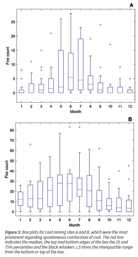
In Figure 5 the active fire counts for site A and B are presented in a monthly box plot. From the figure it is evident that there is a relatively well-defined seasonal pattern in recorded burning activities, with burning more prevalent during the colder and drier months. Although this pattern coincides with the open biomass burning season in the South African Highveld (e.g. Maritz et al. 2019), open biomass burning is unlikely the cause for significant increases in burning for the specific coal mining sites considered, as it is impossible for the same natural area (savannah/grassland) to burn multiple times in one month and for consecutive months. A possible cause for this observed seasonal variation could be the moisture content present in the coal. It has been found that the moisture content of coal could increase or decrease the probability for coal to self-heat and spontaneously combust (Bhat and Agarwal 1996; Xu et al. 2013). If the coal is saturated with moisture, a negligible rate of oxidation occurs and self-heating of the coal is not possible (Bhat and Agarwal 1996). However, when the coal dries during the drier months, the condensation of moisture releases latent heat associated with vaporization, which raises the heat of the coal particles and increases the potential for spontaneous combustion (Bhat and Agarwal 1996), thus the coal will be more likely to self-heat and spontaneously combust during the drier months as little to no rainfall will be occur.
Case study of emissions originating from a spontaneous combustion event
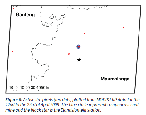
Considering the extended time and repetitive nature of the spontaneous coal combustion fires considered in this paper, these events will emit substantial amounts of atmospheric pollutants. To illustrate this a case study is presented of a plume originating from one such spontaneous combustion event, which was measured at the Elandsfontein measurement station in the Mpumalanga Highveld. In Figure 6 active fire pixels for the burning activity under investigation is presented. On the 22nd -23rd of April 2009 a total of 3 fires were recorded within the blue circle in Figure 6, the blue circle is representative of the opencast coal mine used in this case study.
In Figure 7 a HYSPLIT dispersion calculation (Stein et al. 2015; Rolph et al. 2017) is presented for mining site B on the 23rd of April 2009. The model was set to run from the 22nd of April at 23:00 for 24 hours with parameters displayed in Table 2.

As is evident from the dispersion calculation in Figure 7, pollutants released by the case study spontaneous coal combustion event passed over the Elandsfontein atmospheric measurement site. Figure 8 represents the hourly concentrations of trace gases (NO, NO2, SO2 and H2S), as well as eBC measured here, on the 23rd of April 2009. As is apparent, an increase in all species except NO is observed from 00:00, which reaches a peak at about 02:30 and decreases till 05:00. The increase in ambient trace gas and eBC concentrations are observed at the same time as the HYSPLIT dispersion calculations determined that the polluted air parcel from the spontaneous coal combustion source would reach the measurement station. Other peaks, after 05:00 in Figure 8, are also evident, but these are not discussed in this paper, since the authors will publish a full source apportionment study of trace gases measured at Elandsfontein within the foreseeable future. Considering Figures 6 to 8, it can be stated that substantial amounts of NO2, SO2, H2S and eBC were released by the spontaneous coal combustion event, as H2S and SO2 were in excess of 10 ppb, approximately 23 km downwind of the source.


Conclusions
From this study it is evident that spontaneous combustion of coal in the Mpumalanga Highveld has a large environmental impact especially on air quality. Through the use of FRP data it was found that five mining sites were prone to spontaneous combustions over a period of 19 years. These sites were all opencast mines, situated on top of old bord and pillar mines. Of these five sites, two (A and B) were actively burning almost continually for the whole study period. A relatively well-defined seasonal pattern was observed for the spontaneous combustion activities, which were attributed to the suppression of such events during the rainy season. A case study pollution plume originating from a spontaneous coal combustion event, captured at the Elandsfontein measurement site, recorded high concentrations of NO2, SO2, H2S and eBC originating from location B. Source apportionment of the contribution of spontaneous coal combustion in comparison with other sources is currently ongoing and the authors hope to publish that within the foreseeable future.
The FRP-based method we used here, demonstrates that remote sensing observations can be utilised to determine when there is spontaneous coal combustion at a site and can be applied throughout the world if the locations of mining activities is known. Furthermore, it offers a way to incorporate the emissions in air quality models (see e.g. Sofiev et al. 2009), once the emission factors have been quantified. However, the resolution of the MODIS instrumentation and frequency the satellite passes over an area might be limiting in detecting smaller combustion events.
Acknowledgements
The authors gratefully acknowledge the NOAA Air Resources Laboratory (ARL) for the provision of the HYSPLIT transport and dispersion model and READY website (https://www.ready.noaa.gov) used in this publication.
References
Bell F.G, Bullock S.E.T, Halbich T.F.J & Lindsay P, 2001, 'Environmental impacts associated with an abandoned mine in the Witbank Coalfield, South Africa', International Journal of Coal Geology, 45:2-3, doi: 10.1016/S0166-5162(00)00033-1. [ Links ]
Beukes J.P, Van Zyl P.G, Sofiev M, Soares J, Liebenberg-Enslin H, Shackleton N & Sundstrom A.-M, 2018,'The use of satellite observations of fire radiative power to estimate the availabilities (activity patterns) of pyrometallurgical smelters', The Journal of the Southern African Institute of Mining and Metallurgy, 118:6, doi: 10.17159/2411-9717/2018/v118n6a9. [ Links ]
Bhat S & Agarwal P.K, 1996, 'The effect of moisture condensation on the spontaneous combustibility of coal', Fuel, 75:13, doi: 10.1016/0016-2361(96)00121-4. [ Links ]
Carras J.N, Stuart D.J, Saghafi A & Williams D.J, 2009, 'Greenhouse gas emissions from low-temperature oxidation and spontaneous combustion at open-cut coal mines in Australia', International Journal of Coal Geology, 78:2, doi: 10.1016/j. coal.2008.12.001. [ Links ]
Collet K.S, Piketh S.J, Ross K.E, 2010, An assessment of the atmospheric nitrogen budget on the South African Highveld, South African Journal of Science, 106(5/6), doi: 10.4102/sajs. v106i5/6.220. [ Links ]
Giglio L, Descloitres J, Justice C.O, Kaufman Y.j, 2003, An Enhanced Contextual Fire Detection Algorithm for MODIS, Remote Sensing of Environment, 87, 2-3, doi: 10.1016/S0034-4257(03)00184-6. [ Links ]
Giglio L, Schroeder W, Justice C.O, 2016, The collection 6 MODIS active fire detection algorithm and fire products, Remote Sensing of Environment, 178, doi: 10.1016/j.rse.2016.02.054. [ Links ]
Hu Z, Zhang M, Chen S, Ma B, Zhao Y & Li J, 2009, 'Pollution generation, migration and in situ control measures on coal refuses', Procedia Earth and Planetary Science, 1:1, doi:10.1016/j.proeps.2009.09.182. [ Links ]
Hyvärinen A.P, Vakkari V, Laakso L, Hooda R.K, Sharma V.P, Panwar T, Beukes J.P, van Zyl P.G, Josipovic M, Garland R.M, Andreae M.O, Pöschl U, Petzold A, 2013, Correction for a measurement artifact of the Multi-Angle Absorption Photometer (MAAP) at high black carbon mass concentration levels. Atmos. Meas. Tech., 6, 81-90, http://dx.doi.org/10.5194/amt-6-81-2013. [ Links ]
Justice C.O, Giglio L, Korontzi S, Owens J, Morisette J.T, Roy D, Descloitres J, Alleaume S, Petitcolin F & Kaufman Y, 2002, 'The MODIS fire products', Remote Sensing of Environment, 83, 1-2, doi: 10.1016/S0034-4257(02)00076-7. [ Links ]
Kaufman Y.J, Justice C.O, Flynn L.P, Kendall J.D, Prins E.M, Giglio L, Ward D.E, Menzel W.P & Setzer A, 1998, 'Potential global fire monitoring from EOS-MODIS', Journal of Geophysical Research, 103:D24, pp. 32,215-32,238. [ Links ]
Laakso L, Vakkari V, Virkkula A, Laakso H, Backman J, Kulmala M, Beukes J.P, Van zyl P.G, Titta P, Josipovic M, Pienaar J.J, Chiloane K, Gilardoni S, Vignati E, Wiedensohler A, Tuch T, Birmili W, Piketh S, et al. 2012, South African EUCAARI measurements: seasonal variation of trace gases and aerosol optical properties, Atmospheric Chemistry and Physics, 12:1847-1864, doi: 10.5194/acp-12-1847-2012. [ Links ]
Maritz P, Beukes J.P, Van Zyl P.G, Liousse C, Gardrat E, Ramandh A and Mkhatshwa G.V, Temporal and source assessments of organic and elemental carbon at sites in the northern South African interior, Journal of Atmospheric Chemistry, 76, 263-287,2019. http://dx.doi.org/10.1007/s10874-020-09398-2. [ Links ]
Mucina L, Rutherford M.C, 2006, The vegetation of South Africa, Lesotho and Swaziland. Strelitzia 19. South African National Biodiversity Institute, Pretoria. [ Links ]
Petzold A, Ogren J.A, Fiebig M, Laj P, Li S.-M, Holzer-Popp T, Kinne S, Pappalardo G, Sugimoto N, Wehrli C, Wiedensohler A, Zhang X.-Y, 2013, Recommendations for reporting "black carbon" measurements. Atmospheric Chemistry and Physics, 13, 83658379, doi: 10.5194/acp-13-8365-2013. [ Links ]
Pone D.J.N, Hein K.A.A, Stracher G.B, Annegarn H.J, Finkleman R.B, Blake D.R, McCormack J.K & Schroeder P, 2007, 'The spontaneous combustion of coal and its by-products in the Witbank and Sasolburg coalfields of South Africa', International Journal of Coal Geology, 72, doi: 10.1016/j.coal.2007.01.001. [ Links ]
Rolph G, Stein A & Stunder B, 2017, 'Real_time Environmental Application and Display sYstem: READY', Environmental Modelling & Software, 95, doi: 10.1016/j.envsoft.2017.06.025. [ Links ]
Sloss L, 2013, 'Quantifying emissions from spontaneous combustion', IEA Clean Coal Centre, 224, viewed 8 October 2020, https://usea.org/sites/default/files/092013_Quantifying%20emissions%20from%20spontaneous%20combustion _ccc224.pdf. [ Links ]
Sofiev, M., Vankevich, R., Lotjonen, M., Prank, M., Petukhov, V., Ermakova, T., Koskinen, J., and Kukkonen, J.: An operational system for the assimilation of the satellite information on wild-land fires for the needs of air quality modelling and forecasting, Atmospheric Chemistry and Physics, 9, 6833-6847, https://doi.org/10.5194/acp-9-6833-2009, 2009. [ Links ]
Stein A.F, Draxler R.R, Rolph G.D, Stunder B.J.B, Cohen M.D & Ngan F, 2015, 'NOAA's HYSPLIT atmospheric transport and dispersion modelling system', Bulletin of the American Meteorological Society, 96:12, doi: 10.1175/BAMS-D-14-00110.1. [ Links ]
Stracher G.B & Taylor T.P, 2004, 'Coal fires burning out of control around the world: thermodynamic recipe for environmental catastrophy', International Journal of Coal Geology, 59, doi:10.1016/j.coal.2003.03.002. [ Links ]
Xu T, Wang D.-M & He Q.-L, 2013, 'The study of the Critical Moisture Content at Which Coal Has the Most High Tendency to Spontaneous Combustion', International Journal of Coal Preparation and Utilization, 33:117-127, doi: 10.1080/19392699.2013.769435. [ Links ]
Received: 16 September 2021
Reviewed: 8 February 2022
Accepted: 12 July 2022

