


Services on Demand
Article
 English (pdf)
 Article in xml format
 Article references
Indicators

Related links
-
 Cited by Google
 -
 Similars in Google
Share

 Permalink
Clean Air Journal
On-line version ISSN 2410-972X
Print version ISSN 1017-1703
Clean Air J. vol.30 n.1 Pretoria 2020
http://dx.doi.org/10.17159/caj/2020/30/1.8066
RESEARCH ARTICLE
Evaluating the potential of remote sensing imagery in mapping ground-level fine particulate matter (PM25) for the Vaal Triangle Priority Area
Luckson MuyemekiI; Roelof BurgerII; Stuart J. PikethIII
IUnit for Environmental Sciences and Management, North-West University, Potchefstroom Campus, Potchefstroom, 2520, South Africa, lucksonmuyemeki@gmail.com
IIUnit for Environmental Sciences and Management, North-West University, Potchefstroom Campus, Potchefstroom, 2520, South Africa, roelof.burger@nwu.ac.za
IIIUnit for Environmental Sciences and Management, North-West University, Potchefstroom Campus, Potchefstroom, 2520, South Africa, stuart.piketh@nwu.ac.za
ABSTRACT
The quality of air breathed in South Africa is of great concern, especially in industrialised regions where PM25 concentrations are high. Long term exposure to PM25 is associated with serious adverse health impacts. Traditionally, PM25 is monitored by a network of ground-based instruments. However, the coverage of monitoring networks in South Africa is not dense enough to fully capture the spatial variability of PM25 concentrations. This study explored whether satellite remote sensing could offer a viable alternative to ground-based monitoring. Using an eight-year record (2009 to 2016) of satellite retrievals (MODIS, MISR and SeaWIFS) for PM25 concentrations, spatial variations and temporal trends for PM2.5 were evaluated for the Vaal Triangle Airshed Priority Area (VTAPA). Results were compared to corresponding measurements from the VTAPA surface monitoring stations. High PM25 concentrations were clustered around the centre and towards the south-west of the VTAPA over the highly industrialised cities of Vanderbijlpark and Sasol-burg. Satellite retrievals tended to overestimate PM25 concentrations. Overall, there was a poor agreement between satellite-retrieved PM25 estimates and ground-level PM25 measurements. Root mean square error values ranged from 6 to 11 μg/m3 and from -0.89 to 0.32 for the correlation coefficient. For satellite remote sensing to be effectively exploited for air quality assessments in the VTAPA and elsewhere, further research to improve the precision and accuracy of satellite-retrieved PM25 is required.
Keywords: Satellite retrievals, ground-based data, PM25 concentration, spatial variations
Introduction
At a global scale, air pollution is ranked fourth amongst the leading risk factors to human health, with recent estimates linking it to over 5 million premature deaths (Mannucci and Franchini, 2017; Bhanarkar et al., 2018; Health Effects Institute, 2019). In sub-Saharan Africa (SSA), particularly in the urban areas, the deterioration in air quality as a result of rapid urbanisation, population growth and industrial expansion is evident (Amegah and Agyei-Mensah, 2017; Fayiga, Ipinmoroti and Chirenje, 2018). Of great concern to public health, are the levels of fine particulate matter (PM25) in the cities of SSA, which are amongst the highest in the world (Fayiga, Ipinmoroti and Chirenje, 2018; Katoto et al., 2019). Long-term exposure to high levels of PM25 is harmful to humans as it can lead to increased severity in the symptoms of asthma and chronic obstructive pulmonary disease (Dieme et al., 2012; Feng et al., 2016).
In South Africa, air pollution has become an important issue, especially in industrialised regions like the Vaal Triangle Airshed Priority Area (VTAPA) where strong economic growth has taken place (Naiker et al., 2012; Zhu et al., 2012). The VTAPA routinely experiences poor air quality as a result of strong emissions from industries, residential burning, vehicles and fugitive dust sources coupled with unfavourable meteorological conditions that have led to the accumulation of PM25 in high concentrations (Annegarn and Scorgie, 1997; Scorgie et al., 2003).
To improve air quality and public health in the VTAPA, the Department of Environmental Affairs (DEA) developed an air quality management plan that outlined strategies to reduce emissions from key sources (Department of Environmental Affairs and Tourism, 2009; Tshehla and Wright, 2019). Furthermore, air quality monitoring stations were placed at identified hotspots in the VTAPA, so as to assess pollution trends and to ascertain whether concentrations of PM25 and other pollutants are being kept within the regulatory limits (Ngcukana, 2016; Altieri and Keen, 2019). However, similar to other urban areas across the world ( Gupta et al., 2006; Tian and Chen, 2010; Hu et al., 2014), the spatial coverage of stationary ambient monitors in the VTAPA is low. Intra-urban variability of PM25 concentrations is therefore not accounted for. In order to capture the full-scale variability of PM25 concentrations in the VTAPA, there is need for a vast network of monitoring stations. However, this requires large financial resources (Munir et al., 2016).
Satellite remote sensing can provide repeated observations of atmospheric pollution at large spatial scales. The monitoring of air pollutants using satellite observations is gradually gaining more attention in atmospheric pollution studies (Engel-Cox, Hoff and Haymet, 2004; Duncan et al., 2014). Advancements in regional algorithms have allowed for the large scale retrieval of PM2.5 concentrations at fine spatial resolutions that have a reasonable agreement with ground measurements (van Donkelaar et al., 2015; van Donkelaar et al., 2016). These retrievals have been successfully used to assess long term spatial-temporal patterns of PM25 in regions experiencing poor air quality such as China and Saudi Arabia (Lu et al., 2017; Munir et al., 2016; Shi et al., 2012).
In the case of South Africa, knowledge on the applicability of remote sensing to monitor air pollution levels is insufficient. A regional case study by Kneen et al. (2016) revealed that satellite technology has the potential to offer a practical and credible option to ground-based monitoring in South Africa. However, further investigation is still required in order to have more concrete evidence to advocate the use of remote sensing for air quality monitoring in South Africa. This study evaluated the potential use of remote sensing imagery for air quality assessment in the VTAPA using a publicly available high resolution remotely sensed PM2.5 concentration global dataset developed by van Donkelaar et al. (2015). This dataset begins in 1998 and ends in 2016. Spatial variations in satellite-retrieved PM25 concentrations were examined, and temporal trends were explored.
Methods
Study region
The VTAPA is an industrialised region lying on the South African Highveld, a high central plateau of South Africa that forms part of the grassland biome. It stretches from southern Gauteng down to the northern section of the Free State province with an area of over 4 900 km2 (Figure 1). The region is host to industries including iron and steel manufacturers (ArcelorMittal steel and Davesteel), ferroalloy (Samancor Metalloys) and petrochemical companies (Sasol Chemical Industries, Natref and Omnia fertilisers). Eskom's Lethabo power station is also located in this region.
The VTAPA has a population of over 3 million people with most of its inhabitants residing in south-western Johannesburg, Soweto, Sebokeng, Sharpeville, Vereeniging, Vanderbijlpark, Sasolburg and Zamdela.
Satellite-derived data
Global satellite-derived PM25 concentration data with a high spatial resolution (1 km x 1 km) covering a 10-year period from 2007 to 2016 was obtained from the Atmospheric Composition Analysis Group of Dalhousie University (http://fizz.phys.dal.ca/~atmos/martin/). This global dataset was generated by merging satellite retrievals of AOD (Aerosol Optical Depth) from the NASA MODIS (MODerate resolution Imaging Spectroradiometer), MISR (Multi-angle Imaging SpectroRadiometer) and SeaWIFS (Sea-viewing Wide Field-of-view Sensor) instruments with AOD simulated using the GEOS-Chem chemical transport model in order to produce PM25 estimates (van Donkelaar et al., 2016). The PM25 estimates were then calibrated by means of a Geographically Weighted Regression (GWR) based on ground observations (van Donkelaar et al., 2015). These estimations have a good agreement with ground-based PM25 measurements (R2 = 0.81, slope of 0.82).
Based on previous research, uncertainty may exist in the global PM2.5 data as a result of the satellite retrieval method (van Donkelaar et al., 2015). Existing studies have resolved this by applying a three-year average as an annual average (Han, Zhou and Li, 2015; Peng et al., 2016; Shisong et al., 2018). For this research, three-year moving averages were applied to the satellite retrievals from the period 2009 to 2016. A subset of the global PM25 dataset for each year was extracted to cover the VTAPA study area using the Integrated Land and Water Information System (ILWIS) program (ITC, 2011).
Ground measured data
The VTAPA air quality monitoring network consists of six stations (Figure 1), which are located in Diepkloof (26.2507S, 27.9564E), Kliprivier (26.4203S, 28.0849E), Sebokeng (26.5878S, 27.8402E), Sharpeville (26.6898S, 27.8678E), Three Rivers (26.6583S, 27.9982E) and Zamdela (26.8449S, 27.8551E), and have been operational since 2007. Based on the simulated spatial distribution of air pollutants from dispersion modelling these monitoring stations, except for Kliprivier, are considered to be located in high PM10 concentration zones (Thomas, 2008; Department of Environmental Affairs and Tourism, 2009; Ngcukana, 2016). PM25 concentration data (2007-2016) for the VTAPA network was acquired from the South African Air Quality Information System (SAAQIS). This data was quality checked by removing negative values. For consistency with the satellite retrievals, three-year moving averages were also applied to the ground PM25 concentration data from the period 2009 to 2016.
Results and discussion
Comparison of temporal variations between satellite-retrieved and ground measured PM25 concentrations
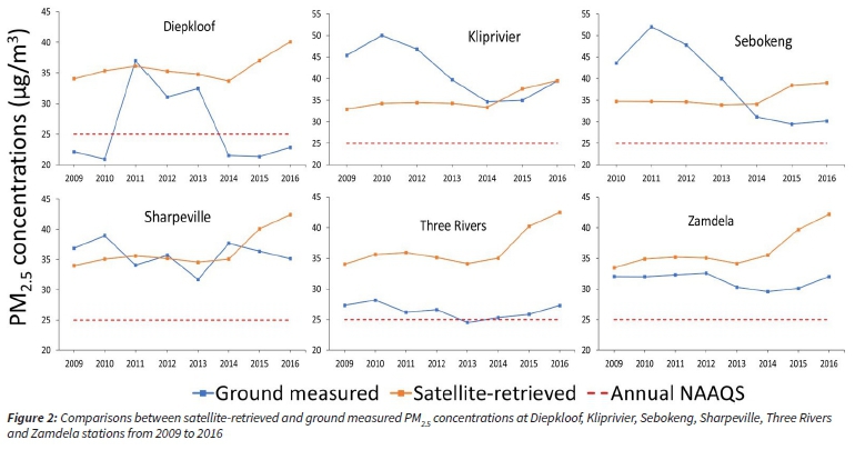
A comparison between satellite-retrieved and ground measured PM2.5 concentrations for the six monitoring stations in the VTAPA for the period 2009-2016 is shown in Figure 2. It can be observed that in most cases, there was an overestimation of observed PM2.5 concentrations by the satellite retrievals, with the exception for the Kliprivier and Sebokeng stations, where ground measurements were much higher than the satellite-retrieved estimates. Both satellite retrievals and ground measurements showed that PM2.5 concentrations for all sites, except Diepkloof, were above the annual National Ambient Air Quality Standards (NAAQS).
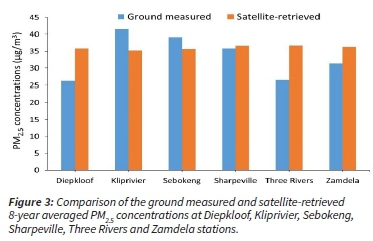
Figure 3 shows the 8-year averages for satellite-retrieved and ground observed PM2.5 concentrations at all stations. The Sharpeville station had the smallest offsets with a difference of 0.7 μg/m3 between observed measurements and estimates retrieved from satellite imagery. Fairly high offsets were observed for the Sebokeng (-4 μg/m3), Zamdela (5 μg/m3) and Klipriver stations (-6 μg/m3). The performance of the satellite retrieved model was less encouraging for the Diepkloof and Three Rivers stations that both had considerably large offsets of 10 μg/m3.
Satellite retrieval performance evaluation
Satellite retrievals for PM25 were compared with the ground measurements from all monitoring stations for the period 2009 to 2014 using the following performance evaluation metrics: root mean square error (RMSE) and correlation coefficient (R). These statistics were computed in R statistical software using the modstat function in the Open Air package. RMSE values ranged from 6 to 11 μg/m3, with an average of 9 μg/m3, indicating a significant difference between ground measured and satellite-retrieved PM25 values (Table 1). R values for the years 2009-2012 ranged from -0.70 to -0.89, demonstrating strong negative correlations between satellite retrievals and ground-based measurements. These inverse relationships, however, do not imply a good agreement between satellite-retrieved PM2.5 estimates and ground-level PM2.5 measurements. R values from the period 2013 to 2016, displayed weak correlations between ground measured and satellite-retrieved PM25 concentrations.

Spatial variations of satellite-derived PM25 concentrations
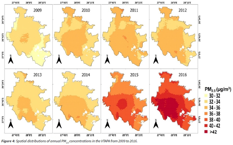
Variations in annual PM25 concentrations over the VTAPA from 2009 to 2016 are presented in Figure 4. The average PM25 concentrations in this region increased significantly by 25% from 33 μg/m3 in 2009 to 41 μg/m3 in 2016. This large increase took place mainly from 2015 to 2016, during which the highest concentrations (41 μg/m3-44 μg/m3) were observed in the VTAPA. The high PM2.5 concentrations from 2015 to 2016 could possibly be due to increased AOD resulting from changes in aerosol mass transport during the El Niño episodes experienced in South Africa. El Niño events can increase regional aerosol concentrations by altering atmospheric circulation systems which leads to changes in the transport and removal of aerosols (Yu et al., 2019). Wang et al., (2019) found a positive link between the El Niño Southern Oscillation (ENSO) index and PM25 concentrations in North China during the 2015/2016 El Niño event. Mean PM25 concentrations in North China were significantly higher in 2015 (51 μg/m3-95 μg/ m3) as compared to 2017 (41 μg/m3-74 μg/m3).
Similar spatial patterns for PM2.5 concentrations in the VTAPA were observed throughout the period (2009-2016) in which the majority of PM pollution is concentrated around the centre and towards the south-western region of the VTAPA. These spatial patterns are comparable to those observed by Thomas (2008), who modelled PM10 concentrations in the VTAPA using a dispersion model. Due to the low dispersion potential of pollutants in the VTAPA, high PM2.5 concentrations were clustered in the central to the south-west region over the cities of Vanderbijlpark and Sasolburg, where heavy industrial (iron and steel, ferroalloy and petrochemical) activities, domestic burning and mine operations take place. Spatial distributions for the VTAPA show that high PM25 concentrations were also concentrated in the northern part of the area. The main source for PM2.5 in this area is residential combustion from the Soweto township and windblown dust from gold mine dumps.
Conclusion
This study evaluated the potential value of satellite remote sensing as a viable alternative to PM2.5 ground-based monitoring in the VTAPA. There was a poor agreement between satellite-retrieved PM2.5 estimates and ground-level PM2.5 measurements. Satellite retrievals tended to overestimate PM2.5 concentrations resulting in inflated values throughout most of the VTAPA. According to Kneen et al. (2016), due to financial constraints in South Africa, monitoring stations are placed in regions with the predicted worst air quality that is mainly urban and industrial centres. This will lead to mainly high values being used in the calibration of PM25 estimates in the GWR model which in turn can result in the overestimation of satellite-retrieved PM2.5 concentrations. Therefore, in order to improve the accuracy of the GWR model for satellite retrievals, the positioning of ground-based stations in South Africa needs to be optimised so as to have monitoring data that is more spatially representative.
The relationship between AOD and PM25 is an important source of uncertainty in satellite retrieval accuracy as the AOD-PM2.5 relationship can vary across space and countries. This could have contributed to some of the inconsistencies between ground measured and satellite-derived PM2.5 concentrations for the VTAPA. There is a need for an independent assessment of the AOD-PM25 relationship through an integrated monitoring strategy like SPARTAN (Surface PARTiculate mAtter Network) in which PM25 monitoring instruments are collocated with ground-based sun photometers for AOD measurements. This will help in evaluating AOD-PM2.5 model accuracy and enhance PM2.5 estimates from satellite AOD retrievals.
Acknowledgements
We would like to thank DEA, SAAQIS and SAWS for the provision of the ground monitoring data used in validating the accuracy of the satellite retrievals.
Author contributions
The majority of the work was conducted by Luckson Muyemeki, who was responsible for data processing, analysis, interpretation, and writing the manuscript. Stuart. J. Piketh and Roelof Burger conceptualised the study and assisted in interpretation of data and editing the manuscript.
References
Altieri, K. E. and Keen, S. L. (2019) 'Public health benefits of reducing exposure to ambient fine particulate matter in South Africa', Science of the Total Environment, 684, pp. 610-620. https://doi:10.1016/j.scitotenv.2019.05.355. [ Links ]
Amegah, A. K. and Agyei-Mensah, S. (2017) 'Urban air pollution in Sub-Saharan Africa: Time for action', Environmental Pollution, 220, pp. 738-743. https://doi:10.1016/j.envpol.2016.09.042. [ Links ]
Annegarn, H. and Scorgie, Y. (1997) 'Air quality management plan for the Vaal Triangle Part II', Clean Air Journal, 9(8), pp. 11-20. https://doi.org/10.17159/caj/1997/9/8.7327 [ Links ]
Bhanarkar, A.D., Purohit, P., Rafaj, P., Amann, M., Bertok, I., Cofala, J., Rao, P.S., Vardhan, B.H., Kiesewetter, G., Sander, R., Schopp, W., Majumdar, D., Srivastava, A., Deshmukh, S., Kawarti, A., and Kumar, R. (2018) 'Managing future air quality in megacities: Co-benefit assessment for Delhi', Atmospheric Environment, 186, pp. 158-177. https://doi:10.1016/j.atmosenv.2018.05.026. [ Links ]
Carslaw, D. C. and Ropkins, K. (2012) 'Openair - An r package for air quality data analysis', Environmental Modelling and Software, 27-28, pp. 52-61. https://doi:10.1016/j.envsoft.2011.09.008. [ Links ]
Department of Environmental Affairs and Tourism (2009) Vaal Triangle air-shed priority area air quality management plan. Available at: https://www.environment.gov.za/sites/default/files/gazetted_notices/nemaqa_airqualityact_g31615gon1241_0.pdf [ Links ]
Dieme, D., Cabral-Ndior, M., Garçon, G., Verdin, A., Billet, S., Cazier, F., Courcot, D., Diouf, A., and Shirali, P. (2012) 'Relationship between physicochemical characterization and toxicity of fine particulate matter (PM2.5) collected in Dakar city (Senegal)', Environmental Research, 113, pp. 1-13. https://doi:10.1016/j.envres.2011.11.009. [ Links ]
van Donkelaar, A., Martin, R. V, Brauer, M., and Boys, B.L. (2015) 'Use of satellite observations for long-term exposure assessment of global concentrations of fine particulate matter', Environmental Health Perspectives, 123(2), pp. 135-143. https://doi.org/10.1289/ehp.1408646. [ Links ]
van Donkelaar, A., Martin, R. V., Brauer, M., Hsu, N.C., Kahn, R.A., Levy, R.C., Lyapustin, A., Sayer, A.M., and Winker, D.M. (2016) 'Global estimates of fine particulate matter using a combined geophysical-statistical method with information from satellites, models, and monitors', Environmental Science and Technology, 50(7), pp. 3762-3772. https://doi:10.1021/acs.est.5b05833. [ Links ]
Duncan, B.N., Prados, A.I., Lamsal, L.N., Liu, Y., Streets, D.G., Gupta, P., Hilsenrath, E., Kahn, R.A., Nielsen, J.E., Beyersdorf, A.J., Burton, S.P., Fiore, A.M., Fishman, J., Henze, D.K., Hostetler, C.A., Krotkov, N.A., Lee, P., Lin, M., Pawson, S., Pfister, G., Pickering, K.E., Pierce, R.B., Yoshida, Y., and Ziemba, L.D. (2014) 'Satellite data of atmospheric pollution for U.S. air quality applications: Examples of applications, summary of data end-user resources, answers to FAQs, and common mistakes to avoid', Atmospheric Environment, 94, pp. 647-662. https://doi:10.1016/j.atmosenv.2014.05.061. [ Links ]
Engel-Cox, J. A., Hoff, R. M. and Haymet, A. D. J. (2004) 'Recommendations on the use of satellite remote-sensing data for urban air quality', Journal of the Air and Waste Management Association, 54(11), pp. 1360-1371. https://doi:10.1080/10473289.2004.10471005. [ Links ]
Fayiga, A. O., Ipinmoroti, M. O. and Chirenje, T. (2018) 'Environmental pollution in Africa', Environment, Development and Sustainability, 20(1), pp. 41-73. https://doi:10.1007/s10668-016-9894-4. [ Links ]
Feng, S., Gao, D., Liao, F., Zhou, F., and Wang, X. (2016) 'The health effects of ambient PM25 and potential mechanisms', Ecotoxicology and Environmental Safety, 128, pp. 67-74. https://doi:10.1016/j.ecoenv.2016.01.030. [ Links ]
Gupta, P., Christopher, S. A., Wang, J., Gehrig, R., Lee, Y. and Kumar, N. (2006) 'Satellite remote sensing of particulate matter and air quality assessment over global cities', Atmospheric Environment, 40(30), pp. 5880-5892. https://doi:10.1016/j.atmosenv.2006.03.016. [ Links ]
Han, L., Zhou, W. and Li, W. (2015) 'City as a major source area of fine particulate (PM2.5) in China', Environmental Pollution, 206, pp. 183-187. https://doi:10.1016/j.envpol.2015.06.038. [ Links ]
Health Effects Institute (2019) State of GlobalAir 2019. Available at: http://www.stateofglobalair.org/sites/default/files/soga_2019_report.pdf. [ Links ]
Hu, X., Waller, L.A., Lyapustin, A., Wang, Y., and Liu, Y. (2014) '10-year spatial and temporal trends of PM2.5 concentrations in the southeastern US estimated using high-resolution satellite data', Atmospheric Chemistry and Physics, 14(12), pp. 6301-6314. https://doi:10.5194/acp-14-6301-2014. [ Links ]
ITC (2011) ILWIS - Remote Sensing and GIS software. Available at: https://www.itc.nl/ilwis. [ Links ]
Katoto, P.D.M.C., Byamungu, L., Brand, A.S., Mokaya, J., Strijdom, H., Goswami, N., De Boever, P., Nawrot, T.S., and Nemery, B. (2019) 'Ambient air pollution and health in sub-Saharan Africa: Current evidence, perspectives and a call to action.', Environmental Research, 173, pp. 174-188. https://doi:10.1016/j.envres.2019.03.029. [ Links ]
Kneen, M.A., Lary, D.J., Harrison, W.A., Annegarn, H.J., and Brikowski, T.H. (2016) 'Interpretation of satellite retrievals of PM25 over the southern African interior', Atmospheric Environment, 128, pp. 53-64. https://doi:10.1016/j.atmosenv.2015.12.016. [ Links ]
Lu, D., Xu, J., Yang, D., and Zhao, J. (2017) 'Spatio-temporal variation and influence factors of PM2.5 concentrations in China from 1998 to 2014', Atmospheric Pollution Research, 8(6), pp. 1151-1159. https://doi:10.1016/j.apr.2017.05.005. [ Links ]
Mannucci, P. M. and Franchini, M. (2017) 'Health effects of ambient air pollution in developing countries', International Journal of Environmental Research and Public Health, 14(9), pp. 1-8. https://doi:10.3390/ijerph14091048. [ Links ]
Masiol, M., Squizzato, S., Chalupa, D.C., Utell, M.J., Rich, D.Q., and Hopke, P.K. (2018) 'Long-term trends in submicron particle concentrations in a metropolitan area of the northeastern United States', Science of the Total Environment, 633, pp. 59-70. https://doi:10.1016/j.scitotenv.2018.03.151. [ Links ]
Munir, S., Gabr, S., Habeebullah, T.M., and Janajrah, M.A. (2016) 'Spatiotemporal analysis of fine particulate matter (PM2.5) in Saudi Arabia using remote sensing data', Egyptian Journal of Remote Sensing and Space Science, 19(2), pp. 195-205. https://doi:10.1016/j.ejrs.2016.06.001. [ Links ]
Naiker, Y., Diab, R.D., Zunckel, M., and Hayes, E.T. (2012) 'Introduction of local air quality management in South Africa: Overview and challenges', Environmental Science and Policy, 17, pp. 62-71. https://doi:10.1016/j.envsci.2011.11.009. [ Links ]
Ngcukana, L. (2016) Vaal Triangle Priority Area Air Quality Monitoring Network monthly report-May 2016. Available at: http://www.saaqis.org.za/AQDownloads.aspx?type=VAAL. [ Links ]
Peng, J., Chen, S., Lü, H., Liu, Y., and Wu, J. (2016) 'Spatiotemporal patterns of remotely sensed PM2.5 concentration in China from 1999 to 2011', Remote Sensing of Environment, 174, pp. 109-121. https://doi:10.1016/j.rse.2015.12.008. [ Links ]
Scorgie, Y., Kneen, M.A., Annegarn, H.J., and Burger, L.W. (2003) 'Air pollution in the Vaal Triangle - Quantifying source contributions and identifying cost-effective solutions', Clean Air Journal, 13(1), pp. 5-18. https://doi.org/10.17159/caj/2003/13/2.7152 [ Links ]
Shi, W., Wong, M.S., Wang, J., and Zhao, Y. (2012) 'Analysis of airborne particulate matter (PM2.5) over Hong Kong using remote sensing and GIS', Sensors, 12(6), pp. 6825-6836. https://doi:10.3390/s120606825. [ Links ]
Shisong, C., Wenji, Z., Hongliang, G., Deyong, H., You, M., Wenhui, Z. and Shanshan, L. (2018) 'Comparison of remotely sensed PM25 concentrations between developed and developing countries: Results from the US, Europe, China, and India', Journal of Cleaner Production, 182, pp. 672-681. https://doi:10.1016/j.jclepro.2018.02.096. [ Links ]
Thomas, R. G. (2008) An air quality baseline assessment for the Vaal airshed in South Africa. MSc dissertation. Department of Geography, Geoinformatics and Meteorology, Faculty of Natural and Agricultural Science, University of Pretoria. November 2008. [ Links ]
Tian, J. and Chen, D. (2010) 'A semi-empirical model for predicting hourly ground-level fine particulate matter (PM25) concentration in southern Ontario from satellite remote sensing and ground-based meteorological measurements', Remote Sensing of Environment, 114(2), pp. 221-229. https://doi:10.1016/j.rse.2009.09.011. [ Links ]
Tshehla, C. and Wright, C. Y. (2019) '15 years after the National Environmental Management Air Quality Act: Is legislation failing to reduce air pollution in South Africa?', South African Journal of Science, 115(9/10), pp. 2-5. https://doi:10.17159/sajs.2019/6100. [ Links ]
Wang, X., Zhong, S., Bian, X. and Yu, L. (2019) 'Impact of 2015-2016 El Niño and 2017-2018 La Nina on PM25 concentrations across China', Atmospheric Environment, 208, pp. 61-73. https://doi:10.1016/j.atmosenv.2019.03.035. [ Links ]
Yu, X., Wang, Z., Zhang, H., and Zhao, S. (2019) 'Impacts of different types and intensities of El Nino events on winter aerosols over China', Science of the Total Environment. The Author(s), 655, pp. 766-780. https://doi:10.1016/j.scitotenv.2018.11.090. [ Links ]
Zhu, T., Melamed, M., Parrish, D., Gauss, M., Klenner, L.G., Lawrence, M., Konare, A., and Liousse, C. (2012) WMO/IGAC Impacts of megacities on air pollution and climate. Available at: https://igacproject.org/sites/default/files/2016-07/GAW%20Report%20205.pdf. https://doi.org/10.1016/jj.uclim.2012.10.004. [ Links ]
Received: 18 March 2020
Reviewed: 29 April 2020
Accepted: 22 May 2020

