


Services on Demand
Article
 English (pdf)
 Article in xml format
 Article references
Indicators

Related links
-
 Cited by Google
 -
 Similars in Google
Share

 Permalink
Journal of the Southern African Institute of Mining and Metallurgy
On-line version ISSN 2411-9717
Print version ISSN 2225-6253
J. S. Afr. Inst. Min. Metall. vol.122 n.7 Johannesburg Jul. 2022
http://dx.doi.org/10.17159/2411-9717/1602/2022
PROFESSIONAL TECHNICAL AND SCIENTIFIC PAPERS
A review of remote-sensing unmanned aerial vehicles in the mining industry
M. Loots; S. Grobbelaar; E. van der Lingen
Department of Engineering and Technology Management, University of Pretoria, South Africa. S. Grobbelaar: https://orcid.org/0000-0001-8148-2440; E. van der Lingen: https://orcid.org/0000-0003-1648-3564
SYNOPSIS
The increased adoption of unmanned aerial vehicles (UAVs) may improve the productivity and cost-effectiveness of remote sensing in the mining industry. This review's objective is to enable stakeholders to identify possible application adoption, improvement, and innovation opportunities. The review merges a building block strategy and practical screening criteria to identify possible avenues of research to answer the review questions. After the screening process, 72 documents were included in the review. Papers were classified into four categories: exploration, development, exploitation, and reclamation. Fifteen applications were identified, the majority of which were in the exploration phase. The most often researched applications were topographic surveys, reclamation monitoring, and slope management. From the two UAV types identified, multi-rotor vehicles were the most favoured for all applications. From the eight remote sensing techniques identified, photogrammetry was the one most often used. Other techniques were limited because of complexity, cost, or the incompatibility of sensors and UAVs. The review was limited to published papers in academic journals. Future studies could aim to include empirical data on the latest UAV applications used in the mining industry.
Keywords: UAV, remote sensing, mining industry, photogrammetry, monitoring, detection.
Introduction and background
Remote sensing is the science of capturing data with a device that is not in physical contact with the data source. The output is used to create a digital representation of the object. Unmanned aerial vehicles (UAVs) have become favoured instruments for remote sensing applications (Muchiri and Kimathi, 2016). UAVs are capable of sustaining flight without onboard human involvement (Bento, 2008), and are remotely controlled either manually or by a computerized piloting program. The recent enhancement in UAVs, along with remote sensing technologies, have ensured an ever-expanding field of application in industries such as agriculture, forestry, surveying, construction, entertainment, and mining.
Although sensor-equipped UAVs are relatively new to the mining industry, their application has snowballed in terms of scale, speed, and service scope (Ren et al., 2019). For example, Szentpeteri (2016) investigated the use of UAVs for geological modelling and surface pit mapping. Jones et al. (2019) identified advances in applying autonomous UAVs in underground mines. Park and Choi (2020) focused on the applications of UAVs in mineral exploration, exploitation, and reclamation.
This article reviews the status of published academic research in the field and aims to answer the following two questions:
1. Which applications of remote-sensing UAV technology are used in the four phases (exploration, development, exploitation, and reclamation) of mining?
2. Which types of UAV and remote sensing methods are typically used in these applications?
The results may enable researchers to identify gaps in the published research or potential collaborators. In addition, other stakeholders may use re findings to identify possible opportunities for application adoption, improvement, and innovation.
Review method
Search strategy and screening process
A building-blocks search strategy was used to perform a systematic literature review. The three search terms used were 'remote sensing', 'UAV', and 'mining'. The Boolean operator 'AND' was used to include only papers that were relevant for all the terms. The search results excluded 'data mining', and included the following journal paper provisos:
1. South African (SA) Department of Higher Education and Training (DHET) approved journal list
2. Published between 2010 and 2020
3. Indexed in the Scopus or Web of Science databases
4. Written in English
5. Available electronically
6. Relevant to the research questions.
The Scopus database was selected because it is one of the most extensive and most popular databases in the engineering disciplines, and provides the largest number of abstracts and peer-reviewed publications(Roux, van der Lingen, and Botha, 2019); while Web of Science is known as a database in leading scholarly research in the sciences worldwide. Following this screening process, only 72 papers remained from the initial sample.
Data extraction
In the data extraction process, the relevant information is taken from the individual research and stored in a single format (Boland, Cherry, and Dickson, 2017). A total of 72 articles and reviews were eligible for inclusion in the review. Microsoft Excel and ATLAS.ti software were used to extract meaningful data from the screened papers. Full-text academic material was imported into ATLAS.ti and subsequently coded.
Methods of synthesis and analysis
This review was a qualitative study, leaning towards an integrative approach. According to Boland, Cherry, and Dickson (2017), an integrative approach aggregates the primary research data. Therefore it summarizes already defined themes that are used in the industries in such a way that the review questions posed by the specific systematic literature review are answered. The developed codes included were 'mining applications', 'UAV type', 'sensor type', 'remote sensing technique', and 'remote sensing outputs'. The coded documents were grouped according to their applicability to the four phases in mining.
Limitations
The research considered only publications related to mining applications in DHET-approved journals indexed in the Scopus or Web of Science databases. It didn't consider unpublished developments in the industry, research that is kept confidential, or developments for which there are approved or pending patent applications. It also didn't consider developments in related fields that might potentially be implemented in the mining industry. However, the results are relevant to researchers and stakeholders in the mining field since they can use them to identify potential applications, gaps in academic publications, and collaborators.
Year of publication
After the screening process, only articles published from 2015 to 2020 remained in the sample, even though the original search parameters were from 2010 to 2020. The earlier publications focused on how UAV technology can supplement manual methods, but the more recent publications emphasized standalone utilizations of UAVs.
Publication sources, research type, and country of origin
The journals with the most publications were Remote Sensing with nine publications, Sensors with eight, Environmental Earth Sciences with five, and Acta Montanistica Slovaca with three. China (21%) was the top contributor, with Australia (8%) and Italy (8%) following. South Africa published only one article on the review topic.
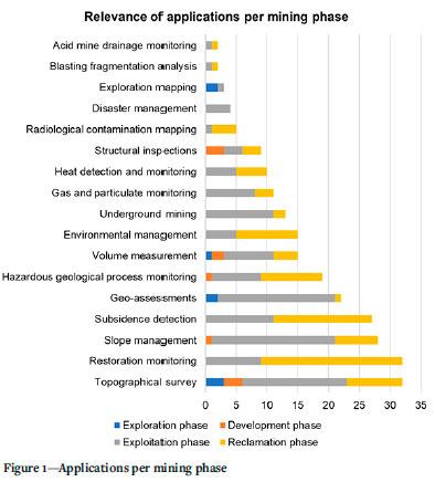
Papers per mining phase and application type
Figure 1 illustrates the number of papers per mining phase and application type. Of the 72 documents reviewed, the majority concerned the exploitation (51) and reclamation phases (41). Several papers included more than one phase. Topographic surveying and restoration monitoring were the applications most frequently observed. The various applications and research findings per phase are discussed in the sections that follow.
Results
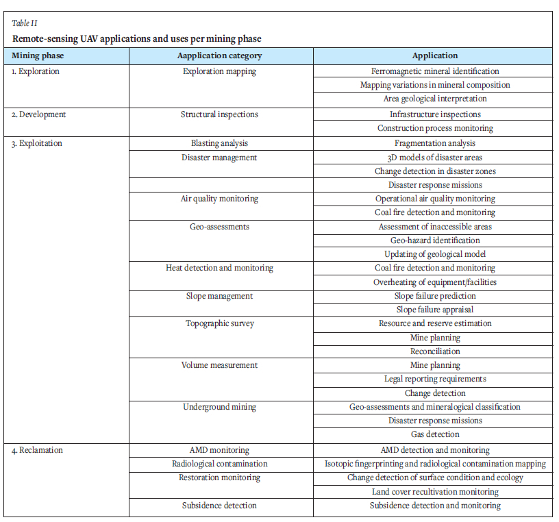
Exploration phase
Four applications - exploration mapping, topographic survey, geo-assessment, and volume measurement - are relevant to this phase, as indicated in Figure 1. Exploration mapping examines the relationship between mineral deposit characteristics and surface geology. Remote sensing technologies used for this include magnetic, hyperspectral, and photogrammetric.
Magnetic imaging uses fluxgate magnetometers to detect variations in the Earth' s magnetic field due to ferromagnetic minerals' magnetism (Heincke et al., 2019). Hyperspectral imaging is used for a broader range of minerals, since every compound displays a unique spectral signature based on the wavelengths of electromagnetic radiation absorbed, emitted, or reflected (Kirsch et al., 2018). An example of a hyperspectral sensor is the visible to near-infrared (VNIR) camera, Senop Rikola, which was used by both Heincke et al. (2019) and Kirsch et al. (2018) in their studies of exploration mapping. Photogrammetry uses multiple 2D images of objects and reconstructs them into a 3D point cloud using triangulation. The models thus created can be grouped as digital elevation models (DEM), digital surface (DSM) models, digital terrain (DTM) models, and orthophotographs or 3D models. Photogrammetry can also be used for RGB (red-green-blue) analysis, which mimics human vision by differentiating objects based on their colour.
Kirsch et al. (2018) integrated terrestrial and UAV exploration surveys by using hyperspectral imaging and photogrammetry. They demonstrated multiple benefits from this integration, such as spectral range, spatial coverage, flexibility, and appropriate validation. The study concluded that remote-sensing-enabled UAVs improve time-efficiency and geological interpretation, and reduce costs. Heincke et al. (2019) used magnetic, hyperspectral, and photogrammetry data-enabled UAVs to produce an integrated mineralogical property map under the EU-funded MULSEDRO project.
Fixed-wing or multi-rotor UAVs can be used to transport the sensors. For exploration mapping, both multi-rotor and fixed-wing UAVs are used. For surveys that require low-elevation and highresolution data, the multi-rotor UAV is preferred. For coverage of large areas that require longer endurance, the fixed-wing UAV is preferred. Heincke et al. (2019) indicated that fixed-wing UAVs are preferable for magnetic mapping, as the multi-rotor UAV motors cause electromagnetic noise that distorts the magnetic sensor readings. Advances in exploration mapping will be dependent on the development of smaller and more lightweight sensors with an extended wavelength range for hyperspectral imaging, and higher resolution for digital cameras (Kirsch et al., 2018). The development and implementation of hydrogen fuel-cell (de Wagter et al., 2020) and hybrid energy systems may also increase flight endurance (Ozbek et al. 2020).
Development phase
The development phase typically includes construction activities such as buildings, infrastructure, and plant used for ore processing, and mineshafts. Within this phase, four applications were identified: slope management, structural inspections, topographic inspections, and volume measurement (see Figure 1).
Surface deformation analysis (SDA) is a method used for structural inspections, employing dense geo-referenced point clouds. The latest point cloud is compared with earlier ones to identify any possible displacement. SDA inspections are traditionally completed by using 3D laser scanners, but remote-sensing UAVs comply with the technical requirements for SDA inspections (Pinto et al., 2020). Photogrammetry is typically used for SDA on UAVs. Structure from motion (SfM) analysis is used with ground-control points to ensure that images are correctly orientated and geo-referenced (Pinto et al., 2020). Pinto et al. (2020) considered the inspection of both a rocky slope and a dam wall to test UAV photogrammetry's applicability to SDA. The inspections were carried out with a multi-rotor UAV equipped with a digital camera and using an aerial robotics cognitive architecture (ARCog) enabling semi-autonomous flight. Decisions were based on the visual data gathered, as well as pre-programmed rules developed and provided by experts under well-known conditions. The project proved that semi-autonomous flights are possible for visual and 3D inspections. Several advantages were highlighted, such as the ability to access difficult areas and to carry out safe and fast inspections. Future work will look into implementing ARCog on multiple UAVs, and developing several machine-learning opportunities such as new behaviour training during missions and improving decision-making processes (Pinto et al., 2020).
Exploitation phase
The exploitation phase is the core of the mining process. This is where the minerals are extracted from the earth and processed into saleable products. The majority of remote-sensing UAV applications are prominent in this phase. Figure 2 is a Sankey diagram for the exploitation phase, showing the applications involved in it. The thickness of the connection line (between phase and application) illustrates the ratio of papers related to both aspects.
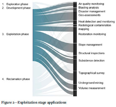
The findings per application type in the exploitation phases are summarized in Table I.
Reclamation phase
This phase focuses on environmental management and restoration monitoring. Applications include acid mine drainage, radiological contamination mapping, restoration monitoring, and subsidence detection.
Acid mine drainage monitoring
Acid mine drainage (AMD) originates from mining operations that produce acidic water and mine waste characterized by low pH values. Its environmental impact has led to a demand that AMD be monitored to enable mitigating strategies. Jackisch et al. (2018) investigated hyperspectral imaging integrated with photogrammetry for AMD mapping. Hyperspectral UAV sensing was used to gather the AMD mineral composition data. Common AMD minerals are jarosite, schwertmannite, goethite, and haematite (Jackisch et al., 2018). These minerals form the basis for mapping AMD areas. A Rikola hyperspectral camera was used on a multi-rotor UAV, which can capture images while hovering. A fixed-wing UAV was used to produce orthophotos and DEM with photogrammetry. The fixed-wing was chosen because it is able to cover a large area owing to its long flight endurance. Both UAVs flew autonomous flights after flight pre-planning. The study used data from surface sampling, such as chemical analysis by spectrometry and pH measurement, for verification and confirmed the feasibility of monitoring AMD with hyperspectral-enabled UAVs.
Radiological contamination mapping
Uranium mining produces waste and tailing storage facilities with high concentrations of radionuclides (Borbinha et al., 2020). These areas pose a high risk to humans, fauna, and flora. Radiological mapping aims to locate, identify, and quantify radiation sources (Borbinha et al., 2020). Martin et al. (2015) used a UAV at low altitude to perform radiological mapping of a disused mining site. The multi-rotor UAV was equipped with a GPS module, a gamma-ray spectrometer sensor, and a laser rangefinder. The gamma-ray spectrometer was a cadmium zinc telluride (CZT) detector. This recorded a spectrum of radiation energy with a time, location, and elevation stamp. The radiation map depicted the radiological intensity of the area by means of a scaled colour overlay. The survey produced metre-scale-accurate radiation measurements within a much shorter time-frame than traditional methods. The data also allowed isotopic fingerprinting of the region to determine the nature of the contamination. Borbinha et al. (2020) employed multi-rotor UAVs with GMCs (Geiger-Muller counters) and CZT gamma-ray spectrometers. A LiDAR UAV was used to develop a 3D model of the studied area. The GMC UAV drone was deployed over the entire area to detect hotspots, after which it hovered close to the ground to gather accurate readings. This allowed the CZT UAV to be deployed in specific hotspot areas to acquire the source spectra (Borbinha et al., 2020). This flight strategy provided radiological contamination maps that could be used for monitoring and control.
Restoration monitoring
Mining operations can cause geomorphic changes owing to their anthropogenic nature (Xiang et al., 2018). Mining rehabilitation and restoration monitoring track progress to determine whether restoration activities are effective. UAVs can capture data on the surface conditions and ecology, and track the process of restoration (Said et al., 2020).
Haas et al. (2016) used photogrammetry to evaluate the impact of geomorphic processes (weathering and erosion) on recultivated mining slopes. Yucel and Turan (2016) used it to determine the anthropogenic and meteorological effects on mine lakes in Turkey. Both studies confirmed that photogrammetry is a useful visualization tool, that can rapidly and accurately detect chang. Xiang et al. (2018) used photogrammetry, DoD, and SLLAC to determine the geomorphic changes during and after mining. DoD was used to calculate the volumetric changes, while SLLAC was used to determine the extent of the mining and to visualize changes to the mine slopes. Gong et al. (2019) used a similar method to assess the effect of erosion on a mine dump site during a freeze-thaw cycle. Satellite images were compared with UAV photogrammetry to quantify the impact of mining on a forest area. Incekara et al. (2017) concluded that UAVs are a more appropriate option than satellite images for monitoring the effects of mining in forested areas. UAV data has higher spatial, spectral, radiometric, and temporal resolutions, with fewer cost and time implications.
Kun (2019) used UAV photogrammetry to develop vegetation index maps of a rehabilitated mine dump site. The maps were used to determine the plant species' adaptation, condition, and survival percentage. The RGB values of the surveyed area were used and characterized according to the triangular greenness index (TGI) and the visible atmospheric resistant index (VARI). Padro et al. (2019) used a multi-rotor UAV equipped with a multispectral sensor to develop DSM, DEM, DTM, vegetation indices, and orthophoto maps showing land cover classifications. This provided to be a fast, high-resolution, and low-cost alternative to traditional restoration monitoring methods. Carabassa et al. (2020) also looked into the use of multispectral sensor UAVs and RGB-enabled digital cameras to determine the land cover classifications of mining areas. Isokangas et al. (2019) evaluated the use of thermal infrared (TIR)- and colour infrared (CIR)-enabled UAVs as a monitoring system for peatland used to purify mine process water. The output consisted of TIR images and blue- normalized difference vegetation index (BNDVI) images. The TIR images indicated cold anomalies, which outlined areas of groundwater seepage, and the BNDVI indicated whether or not vegetation was stressed because of excess water. The method was found to be successful in monitoring treatment peatlands.
Subsidence detection
Although mining has its economic benefits, it has repercussions on the natural environment. Damage to land is evident where open-pit mines leave large voids behind after operations cease (Ren et al., 2019). The impacts of underground mining are less visible, but tend to manifest as surface subsidence (Zhao et al, 2020). Predicting mining-induced subsidence is seen as the basis for implementing proactive measures to reduce its effect (Dawei et al., 2020). Traditional subsidence mapping is prone to data gaps and errors owing to the inaccessibility of surveyed areas, safety issues, and human error. Thus the use of remote-sensing-enabled UAVs to gather information on dangerous and inaccessible areas is highly attractive.
Several studies have considered the use of UAVs for subsidence detection, and highlighted their ability to provide centimetre-scale accuracy from autonomous flight missions. Both fixed-wing and multi-rotor drones have been employed for this purpose. Fixed-wing UAVs are mostly used where large areas have to be mapped, while multi-rotor UAVs are used for smaller areas where high resolution is required (Suh and Choi, 2017). Photogrammetry is the most often-used method, but multispectral imaging and LiDAR scanning are also employed. Suh and Choi (2017) utilized an autonomous multi-rotor UAV to obtain digitally geo-referenced orthophotographs and DTMs to calculate the position, area, and volume of an identified surface subsidence. They emphasized that UAV photogrammetry cannot fully replace traditional methods, which provide subsidence data such as horizontal ground relaxation and crack detection.
Rauhala et al. (2017) used fixed-wing UAV photogrammetry SfM to detect surface displacement on mine tailing facilities. Annual topographical models were used to detect the displacement over the years, and ground checkpoints were used to confirm the accuracy of that information. DoD was used to quantify the ground displacement between individual models. The study found that the models produced by UAV photogrammetry were sufficiently accurate to track surface subsidence of the tailing facilities to a decimetre scale. To obtain information on mining-induced subsidence on cultivated land, Hu and Li (2019) used a multi-rotor UAV equipped with a digital camera to develop vegetation index maps, using characteristic spectral values within the RGB bands. Multispectral and hyperspectral cameras can be employed for higher accuracy vegetation index maps, but the sensors are more costly than standard digital cameras. Zhao et al. (2020) and Ren et al. (2020) used multispectral-enabled UAVs to measure damage to land caused by surface subsidence. Ren et al. (2020) focused on an above-ground biomass (AGB) measurement of the health of maize crops, while Zhao et al. (2020) used soil and plant analyser development (SPAD) to measure and determine the effect of subsidence on corn crops. Both studies indicated that multispectral-enabled UAVs are useful tools for assessing the impact of surface subsidence on reclaimed land.
Cwiakala et al. (2020) studied mining-induced subsidence using traditional field measurements as reference models, to assess UAV photogrammetry's accuracy. Their study also focused on determining horizontal terrain displacements. Both fixed-wing and multi-rotor UAVs were employed in the survey, which showed that UAV photogrammetry could be used to assess the state of surface subsidence. However, the study founded that vegetation coverage was a limitation because it distorted the accuracy of the images. Similar studies by Dawei et al. (2020) and Stupar, Roser, and Vulic (2020) concluded that UAV photogrammetry offers valuable information about subsidence detection and monitoring in a short time-frame without exposing personnel to dangerous environments. Technology, therefore, is highly suited to this application.
Summary of results
Underground mining is the most challenging application for remote-sensing UAVs: it poses implementation challenges, and requires a different navigation and communication architecture to that in the UAVs used for surface mining applications. AMD monitoring, exploration, and radiological contamination mapping are specialized applications, since they need unique sensors. The need for compatibility of the sensors with the limits of a UAV's payload contributes to the slow adoption of these applications. A gap was identified in the case of structural inspections in the mining industry. This application is well-known in the building and construction industries, but the potential for use in mining operations has not been fully realized. Overall, remote sensing has several uses in mining, as discussed in the literature review. A summary is provided in Table II.
Photogrammetry is the most widely used remote sensing technique, accounting for 67% of all applications discussed in the literature review. There is a significant gap between photogrammetry and other applications. Hyperspectral and multispectral remote sensing each account for 9%, followed by remote gas sensing at 6%. The adoption of photogrammetry is mainly a result of advances in the sensors utilized and in post-processing of data obtained from the UAV flight. The cost-effectiveness of digital cameras has increased leading to a significant improvement in quality image. Furthermore, the decreased size and weight of digital cameras has allowed photogrammetry using UAVs to be rapidly and broadly adopted. Advances in tilt imaging systems on UAVs, known as gimbals, enable images to be acquired from any angle without distortions from the drone's movements. Image post-processing is advanced with the SfM algorithm, allowing for the rapid development of any model that is required. Two software applications were prominent in the literature: Agisoft Photoscan and Pix4D, both of which use SfM algorithms to produce highly accurate photogrammetric models.
Other software applications, such as CloudCompare and ShapeMetrix, use the developed models for further analysis. The models can be used in CAD software to update existing geological models with geo-assessments. Algorithms such as DoD, SLLAC, and SDA also use photogrammetric data to determine aspects such as slope movement, displacement, and volume change.
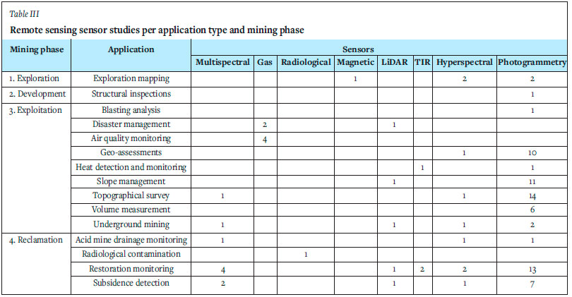
Adoption of remote sensing techniques such as radiological and magnetic remote sensing is limited owing to the specialized nature of the sensors required for specific applications. The size and weight restrictions of UAVs and the high cost of sensors contribute to the slow adoption of hyperspectral, multispectral, LiDAR, and TIR remote sensing techniques. Table III provides a summary of the studies that have evaluated a specific sensor for a specific application and mining phase. Some studies evaluated more than one sensor.
The review identified the following potential benefits of remote sensing aerial vehicles within the mining industry.
> Improved time-efficiency (Kirsch et al., 2018)
> Improved geological interpretation (Kirsch et al., 2018)
> Reduced costs (Kirsch et al., 2018)
> Spatial coverage (Kirsch et al., 2018; Heincke et al., 2019)
> flexibility (Kirsch et al. 2018)
> Semi-autonomous flights for visual and 3D inspections (Pinto et al., 2020)
> Assess ment of difficult areas and safe and fast inspections (Pinto et al., 2020; Said et al., 2020; Ren et al., 2019; Francioni et al., 2015; Leo Stalin and Gnanaprakasam, 2020; Borbinha et al., 2020)
> Monitoring progress to determine whether activities are effective (Said et al., 2020)
> Assessing the impact of surface subsidence (Ren et al., 2020; Zhao et al., 2020; Dawei et al. 2020; and Stupar, Roser, and Vulic, 2020).
Conclusions
This SLR aimed to review the status of academic publications in the field and to answer the following two research questions:
1. Which applications of remote-sensing UAV technology are used in the four phases (exploration, development, exploitation, and reclamation) of mining?
2. Which types of UAV and remote sensing methods are typically used in these applications?
The SLR employed a methodology that identified 72 quality documents on the subjects of remote sensing, UAVs, and mining. A total of 15 applications were identified and synthesized in the four mining phases. The different remote sensing techniques and UAV types were considered for each application type. Most of the research reviewed the exploitation and reclamation phases of mining, with only limited applications identified in the exploration and development phases. Opportunities exist, therefore, to expand remote-sensing UAV applications in these phases. Photogrammetry was the most popular technique by far. Other remote sensing techniques are limited because cost-effective, lightweight, and compact sensors are not yet available. There has been some progress in hyperspectral, multispectral, and LiDAR sensors, but they remain costly and are not entirely suited to UAV implementation. Researchers in the field could use this review to identify gaps in published research and potential collaborators. Stakeholders from the mining industry could use this review to identify relevant applications for opportunities for implementation, improvement, and innovation. Future research may aim to compare the status of academic publications with that of industry developments or patent applications.
References
Alvarado, M., Gonzalez, F., Fletcher, A., and Doshi, A. 2015. Towards the development of a low cost airborne sensing system to monitor dust particles after blasting at open-pit mine sites. Sensors (Switzerland), vol. 15, no. 8, pp. 19667-19687. [ Links ]
Bar, N., KosTADiNOvSKi, M., Tucker, M., Byng, G., Rachmatüllah, R., Maldonado, A., Potsch, M., Gaich, A., McQuillan, A., and Yacoub, T. 2020. Rapid and robust slope failure appraisal using aerial photogrammetry and 3D slope stability models. International Journal of Mining Science and Technology, vol. 30, no. 5, pp.651-658. [ Links ]
Bento, M.D.F. 2008. Unmanned aerial vehicles: An overview. insideGNSS, vol. 3, no. 1. pp.54-61. [ Links ]
Beretta, F., Rodrigues, Á.L., Peroni, R.L., and Costa, J.F.C.L. 2019a. Using UAV for automatic lithological classification of open pit mining front. Revista Escola de Minas, vol. 72, no. 1. pp. 17-23. [ Links ]
Beretta, F., Rodrigues, A.L., Peroni, R.L., and Costa, J.F.C.L. 2019b. Automated lithological classification using UAV and machine learning on an open cast mine. Applied Earth Science: Transactions of the Institute of Mining and Metallurgy, vol. 128, no. 3. pp. 79-88. [ Links ]
Beretta, F., Shibata, H., Cordova, R., Peroni, R.L., Azambuja, J., and Costa, J.F.C.L. 2018. Topographic modelling using UAVs compared with traditional survey methods in mining. Revista Escola de Minas, vol. 71, no. 3. pp. 463-470. [ Links ]
Blistan, P., Kovanic, L\, Patera, M., and Hurcí'k, T. 2019. Evaluation quality parameters of DEM generated with low-cost UAV photogrammetry and structure-from-motion (SfM) approach for topographic surveying of small areas. Acta Montanistica Slovaca, vol. 24, no. 3. pp. 198-212. [ Links ]
Blistan, P., Kovanic, L\, Zeliznaková, V., and Palková, J. 2016. Using UAV photogrammetry to document rock outcrops. Acta Montanistica Slovaca, vol. 21, no. 2. pp. 154-161. [ Links ]
Boland, A., Cherry, M.G., and Dickson, R. 2017. Doing a Systematic Review. SAGE Los Angeles. [ Links ]
Borbinha, J., Romanets, Y., Teles, P., Corisco, J., Vaz, P., Carvalho, D., Brouwer, Y., Luís, R., Pinto, L., Vale, A., Ventura, R., Areias, B., Reis, A.B., and GoNgALves, B. 2020. Performance analysis of geiger-müller and cadmium zinc telluride sensors envisaging airborne radiological monitoring in NORM sites. Sensors (Switzerland), vol. 20, no. 5. 1538. [ Links ]
Carabassa, V., Montero, P., Crespo, M., Padró, J.C., Pons, X., Balagué, J., Brotons, L., and Alcañiz, J.M. 2020. Unmanned aerial system protocol for quarry restoration and mineral extraction monitoring. Journal of Environmental Management, vol. 270. 110717. [ Links ]
Cwiakala, P., Gruszczynski, W., Stoch, T., Puniach, E., Mrochen, D., Matwij, W., Matwij, K., Nedzka, M., Sopata, P., and Wójcik, A. 2020. UAV applications for determination of land deformations caused by underground mining. Remote Sensing, vol. 12, no. 11. 1733. [ Links ]
Dawei, Z., Lizhuang, Q., Demin, Z., Baohui, Z., and Lianglin, G. 2020. Unmanned aerial vehicle (UaV) photogrammetry technology for dynamic mining subsidence monitoring and parameter inversion: A case study in China. IEEE Access, vol. 8. pp. 16372-16386. [ Links ]
De Wagter, C, Remes, B, Ruisink, R, Van Tienen, F., and Van Der Horst, E. 2020, Design and testing of a vertical take-off and landing UAV optimized for carrying a hydrogen fuel cell with a pressure tank. Unmanned Systems, vol. 8, no. 4. pp. 279-285. [ Links ]
Dunnington, L. and Nakagawa, M. 2017. Fast and safe gas detection from underground coal fire by drone fly over. Environmental Pollution, vol. 229, pp.139-145 [ Links ]
Esposito, G., Mastrorocco, G., Salvini, R., Oliveti, M., and Starita, P. 2017. Application of UAV photogrammetry for the multi-temporal estimation of surface extent and volumetric excavation in the Sa Pigada Bianca open-pit mine, Sardinia, Italy. Environmental Earth Sciences, vol. 76, no. 3. 103 p. [ Links ]
Francioni, M., Salvini, R., Stead, D., Giovannini, R., Riccucci, S., Vanneschi, C., and Gulli, D. 2015. An integrated remote sensing-GIS approach for the analysis of an open pit in the Carrara marble district, Italy: Slope stability assessment through kinematic and numerical methods. Computers and Geotechnics, vol. 67. pp. 46-63. [ Links ]
Gong, C., Lei, S., Bian, Z., Liu, Y., Zhang, Z., and Cheng, W. 2019. Analysis of the development of an erosion gully in an open-pit coal mine dump during a winter freeze-thaw cycle by using low-cost UAVs. Remote Sensing, vol. 11, no. 11. 1356 p. [ Links ]
GUl, Y., Hastaoglu, K.O., and Poyraz, F. 2020. Using the GNSS method assisted with UAV photogrammetry to monitor and determine deformations of a dump site of three open-pit marble mines in Eliktekke region, Amasya province, Turkey. Environmental Earth Sciences, vol. 79, no. 11. 248 p. [ Links ]
Haas, F., Hilger, L., Neugirg, F., Umstadter, K., Breitung, C., Fischer, P., Hilger, P., Heckmann, T., Dusik, J., Kaiser, A., Schmidt, J., Della Seta, M., Rosenkranz, R., and Becht, M. 2016. Quantification and analysis of geomorphic processes on a recultivated iron ore mine on the Italian island of Elba using long-term ground-based lidar and photogrammetric SfM data by a UAV. Natural Hazards and Earth System Sciences, vol. 16, no. 5. pp.1269-1288. [ Links ]
He, X., Yang, X., Luo, Z., and Guan, T. 2020. Application of unmanned aerial vehicle (UAV) thermal infrared remote sensing to identify coal fires in the Huojitu coal mine in Shenmu city, China. Scientific Reports, vol. 10, no. 1. 13895. [ Links ]
Heincke, B., Jackisch, R., Saartenoja, A., Salmirinne, H., Rapp, S., Zimmermann, R., Pirttijarvi, M., Sorensen, E.V., Gloaguen, R., Ek, L., Bergstrom, J., Karinen, A., Salehi, S., Madriz, Y., and Middleton, M. 2019. Developing multi-sensor drones for geological mapping and mineral exploration: Setup and first results from the MULSEDRO project. GEUS Bulletin, vol. 43. e2019430302. [ Links ]
Hu, X. and Li, X. 2019. Information extraction of subsided cultivated land in high-groundwater-level coal mines based on unmanned aerial vehicle visible bands. Environmental Earth Sciences, vol. 78, no. 14. pp. 1-11. [ Links ]
Incekara, A.H., Yildirim, O., Susam, T., and Seker, D.Z. 2017. Using unmanned aerial vehicles for open mining areas: Current applications and future potentials. 38th Asian Conference on Remote Sensing - Space Applications: Touching Human Lives. ACRS, New Delhi, India, 2017. [ Links ]
Irimia, A., Gaman, G.A., Pupazan, D., Ilie, C., and Nicolescu, C. 2019. Using drones in support of rescue interventions teams in toxic/flammable/explosive environments. Environmental Engineering and Management Journal, vol. 18, no. 4. pp. 831-837. [ Links ]
Isokangas, E., Davids, C., Kujala, K., Rauhala, A., Ronkanen, A.K., and Rossi, P.M. 2019. Combining unmanned aerial vehicle-based remote sensing and stable water isotope analysis to monitor treatment peatlands of mining areas. Ecological Engineering, vol. 133. pp. 137-147. [ Links ]
Jackisch, R., Lorenz, S., Zimmermann, R., Mockel, R., and Gloaguen, R. 2018. Drone-borne hyperspectral monitoring of acid mine drainage: An example from the Sokolov lignite district. Remote Sensing, vol. 10, no. 3. 385 p. [ Links ]
Jones, E., Sofonia, J., Canales Cardenas, C., Hrabar, S., and Kendoul, F. 2019. Advances and applications for automated drones in underground mining operations. Proceedings of the Ninth International Conference on Deep and High Stress Mining, The Southern African Institute of Mining and Metallurgy, Johannesburg, South Africa, pp. 323-334. [ Links ]
Katuruza, M. and Birch, C. 2019. The use of unmanned aircraft system technology for highwall mapping at Isibonelo Colliery, South Africa. Journal of the Southern African Institute of Mining and Metallurgy, vol. 119, no. 3. pp. 291-295. [ Links ]
Kirsch, M., Lorenz, S., Zimmermann, R., Tusa, L., Mockel, R., Hodl, P., Booysen, R., Khodadadzadeh, M., and Gloaguen, R. 2018. Integration of terrestrial and drone-borne hyperspectral and photogrammetric sensing methods for exploration mapping and mining monitoring. Remote Sensing, vol. 10, no. 9. 1366 p. [ Links ]
Krsak, B., Blistan, P., Paulikova, A., Puskarova, P., Kovanic, L., Palkova, J., and Zeliznakova, V. 2016. Use of low-cost UAV photogrammetry to analyze the accuracy of a digital elevation model in a case study. Measurement: Journal of the International Measurement Confederation, vol. 91. pp. 276-287 [ Links ]
Kun, M. 2019. Assessment and monitoring of rehabilitation studies on coal mine dump site with UAVs. Applied Ecology and Environmental Research, vol. 17, no. 4. pp. 7381-7393. [ Links ]
Lanciano, C. and Salvini, R. 2020. Monitoring of strain and temperature in an open pit using brillouin distributed optical fiber sensors. Sensors (Switzerland), vol. 20, no. 7. 1924. [ Links ]
Lee, S. and Choi, Y. 2016. Reviews of unmanned aerial vehicle (drone) technology trends and its applications in the mining industry. Geosystem Engineering, vol. 19, no. 4. pp. 197-204. [ Links ]
Leo Stalin, J. and Gnanaprakasam, R.C.P. 2020. Application of unmanned aerial vehicle for mapping and modeling of Indian mines. Journal of the Indian Society of Remote Sensing, vol. 48, no. 6. pp. 841-852. [ Links ]
Li, D., Yang, W., Shi, X., Guo, D., Long, Q., Qiao, F., and Wei, Q. 2020. A visual-inertial localization method for unmanned aerial vehicle in underground tunnel dynamic environments. IEEE Access, vol. 8. pp. 76809-76822. [ Links ]
Liu, S., Yu, J., Ke, Z., Dai, F., and Chen, Y. 2020. Aerial-ground collaborative 3D reconstruction for fast pile volume estimation with unexplored surroundings. International Journal of Advanced Robotic Systems, March-April 2020. [ Links ]
Martin, P.G., Payton, O.D., Fardoulis, J.S., Richards, D.A., and Scott, T.B. 2015. The use of unmanned aerial systems for the mapping of legacy uranium mines. Journal of Environmental Radioactivity, vol. 143. pp. 135-140. [ Links ]
Muchiri, N. and Kimathi, S. 2016. A review of applications and potential applications of UAV. Proceedings of the 2016 Annual Conference on Sustainable Research and Innovation, IEEE, vol. 7. pp. 280-283. [ Links ]
Ozbek, E., Yalin, G., Ekici, S., and Karakoc, T.H. 2020, Evaluation of design methodology, limitations, and iterations of a hydrogen fuelled hybrid fuel cell mini UAV, Energy, vol. 213. pp. 1-11 [ Links ]
Padro, J.C., Carabassa, V., Balague, J., Brotons, L., Alcaniz, J.M., and Pons, X. 2019. Monitoring opencast mine restorations using unmanned aerial system (UAS) imagery. Science of the Total Environment, vol. 657. pp. 1602-1614. [ Links ]
Park, S. and Choi, Y. 2020. Applications of unmanned aerial vehicles in mining from exploration to reclamation: A review. Minerals, vol. 10, no. 8. pp. 1-32. [ Links ]
Pinto, M.F., Honorio, L.M., Melo, A., and Marcato, A.L.M. 2020. A robotic cognitive architecture for slope and dam inspections. Sensors (Switzerland), vol. 20, no. 16. pp. 1-19. [ Links ]
Rahman, A., Timms, G., Shahriar, M.S., Sennersten, C., Davie, A., Lindley, C.A., Hellicar, A.D., Smith, G., Biggins, D., and Coombe, M. 2016. Association between imaging and XRF sensing: A machine learning approach to discover mineralogy in abandoned mine voids. IEEE Sensors Journal, vol. 16, no. 11. pp. 4555-4565. [ Links ]
Rauhala, A., Tuomela, A., Davids, C., and Rossi, P.M. 2017. UAV remote sensing surveillance of a mine tailings impoundment in sub-arctic conditions. Remote Sensing, vol. 9, no. 12. pp. 1-14. [ Links ]
Ren, H., Xiao, W., Zhao, Y., and Hu, Z. 2020. Land damage assessment using maize aboveground biomass estimated from unmanned aerial vehicle in high groundwater level regions affected by underground coal mining. Environmental Science and Pollution Research, vol. 27, no. 17. pp. 21666-21679. [ Links ]
Ren, H., Zhao, Y., Xiao, W., and Hu, Z. 2019. A review of UAV monitoring in mining areas: Current status and future perspectives. International Journal of Coal Science and Technology, vol. 6. pp. 320-333. [ Links ]
Rochala, Z., Wojtowicz, K., Kordowski, P., and Brzozowski, B. 2019. Experimental tests of the obstacles detection technique in the hemispherical area for an underground explorer UAV. IEEE Aerospace and Electronic Systems Magazine, vol. 34, no. 10. pp. 18-26. [ Links ]
Roux, R.N., Van der Lingen, E., and Botha, A.P. 2019. A systematic literature review on the titanium metal product value chain. South African Journal of Industrial Engineering, vol. 30, no. 3. pp. 115-133. [ Links ]
Said, K.O., Onifade, M., Githiria, J.M., Abdulsalam, J., Bodunrin, M.O., Genc, B., Johnson, O., and Akande, J.M. 2020. On the application of drones: A progress report in mining operations. International Journal of Mining, Reclamation and Environment, pp. 1-33. [ Links ]
Salvini, R., Mastrorocco, G., Esposito, G., Di Bartolo, S., Coggan, J., and Vanneschi, C. 2018. Use of a remotely piloted aircraft system for hazard assessment in a rocky mining area (Lucca, Italy). Natural Hazards and Earth System Sciences, vol. 18, no. 1. pp. 287-302. [ Links ]
Scannapieco, A.F., Renga, A., and Moccia, A. 2015. Preliminary study of a millimeterwave FMCW InSAR for UAS indoor navigation. Sensors (Switzerland), vol. 15, no. 2,. pp. 2309-2335. [ Links ]
Shahbazi, M., Sohn, G., Theau, J., and Menard, P. 2015. Development and evaluation of a UAV-photogrammetry system for precise 3D environmental modeling. Sensors (Switzerland), vol. 15, no. 11. pp. 27493-27524. [ Links ]
Stupar, D.I., Roser, J., and Vulic, M. 2020. Investigation of unmanned aerial vehicles-based photogrammetry for large mine subsidence monitoring. Minerals, vol. 10, no. 2. pp.196-210 [ Links ]
Suh, J. and Choi, Y. 2017. Mapping hazardous mining-induced sinkhole subsidence using unmanned aerial vehicle (drone) photogrammetry. Environmental Earth Sciences, vol. 76, no. 4. 144. [ Links ]
Szentpeteri, K. 2016. Drones (UAVs) in mining and exploration. An application example: Pit mapping and geological modelling. Unconventional Exploration Target & Latest Technique and New Tools in Mineral and Coal Exploration, October. pp. 34-59. [ Links ]
Tong, X., Liu, X., Chen, P., Liu, S., Luan, K., Li, L., Liu, S., Liu, X., Xie, H., Jin, Y., and Hong, Z. 2015. Integration of UAV-based photogrammetry and terrestrial laser scanning for the three-dimensional mapping and monitoring of open-pit mine areas. Remote Sensing, vol. 7, no. 6. pp. 6635-6662. [ Links ]
Turner, R.M., MacLaughlin, M.M., and Iverson, S.R. 2020. Identifying and mapping potentially adverse discontinuities in underground excavations using thermal and multispectral UAV imagery. Engineering Geology, vol. 266. 105470. [ Links ]
Wang, Y.J., Tian, F., Huang, Y., Wang, J., and Wei, C.J. 2015. Monitoring coal fires in Datong coalfield using multi-source remote sensing data. Transactions of Nonferrous Metals Society of China (English edition), vol. 25, no. 10. pp. 3421-3428. [ Links ]
Xiang, J., Chen, J., Sofia, G., Tian, Y., and Tarolli, P. 2018. Open-pit mine geomorphic changes analysis using multi-temporal UAV survey. Environmental Earth Sciences, vol. 77, no. 6. p. 220. [ Links ]
Yao, H., Qin, R. and Chen, X. 2019. Unmanned aerial vehicle for remote sensing applications - A review. Remote Sensing, vol. 11, no. 12. p. 1443. [ Links ]
Yucel, M.A. and Turan, R.Y. 2016. Areal change detection and 3D modeling of mine lakes using high-resolution unmanned aerial vehicle images. Arabian Journal for Science and Engineering, vol. 41, no. 12. pp. 4867-4878. [ Links ]
Zhao, Y., Zheng, W., Xiao, W., Zhang, S., Lv, X., and Zhang, J. 2020. Rapid monitoring of reclaimed farmland effects in coal mining subsidence area using a multi-spectral UAV platform. Environmental Monitoring and Assessment, vol. 192, no. 7. p. 474. [ Links ]
 Correspondence:
S. Grobbelaar
Email: schalk.grobbelaar@up.ac.za
Received: 19 Apr. 2021
Revised: 18 Mar. 2022
Accepted: 1 Jun. 2022
Published: July 2022

