


Services on Demand
Article
 English (pdf)
 Article in xml format
 Article references
Indicators

Related links
-
 Cited by Google
 -
 Similars in Google
Share

 Permalink
Journal of the Southern African Institute of Mining and Metallurgy
On-line version ISSN 2411-9717
Print version ISSN 2225-6253
J. S. Afr. Inst. Min. Metall. vol.117 n.1 Johannesburg Jan. 2017
http://dx.doi.org/10.17159/2411-9717/2017/v117n1a1
MINING, ENVIRONMENT AND SOCIETY CONFERENCE
Finding the interface between mining, people, and biodiversity: a case study at Richards Bay Minerals
T. Ott
Richard Bay Minerals, Rio Tinto
SYNOPSIS
Mining is often touted as a panacea for poverty and unemployment, particularly in South Africa. The location of valuable mineral resources often coincides with sensitive natural areas, putting development goals in direct opposition to the conservation of biodiversity. Furthermore, people are sometimes relocated, or their access to natural resources limited, to make way for the mine. Once mining begins, the promise of employment and infrastructure brings additional people to the areas surrounding the mine. People in these rural settlements seize the opportunity to enter a cash economy and convert their lands, previously used for subsistence crops, into dormitories for immigrants from other regions or countries. Low-density rural areas therefore gradually become peri-urban settlements, leading to increasing pressure on natural resources. A systemic approach to land use planning is critical to cater for livelihoods through responsible land stewardship and biodiversity conservation during mining and after closure, in collaboration with mining companies.
Richards Bay Minerals has been operating in the kwaMbonambi and kwaSokhulu communities for almost 40 years and has experienced these issues first-hand. Adaptive land planning and management is critical for satisfying stakeholders and maintaining compliance with environmental management programmes and social labour planning requirements. In this paper, we share some of these challenges and how we are attempting to address them on mined land with the development of new projects.
Keywords: rehabilitation, socio-economic development, mining closure, land-use planning, rural communities.
Introduction
Is sustainable development possible? For years, industrial development, particularly in the extractive sector, has been touted as a panacea for unemployment and poverty in South Africa. This has driven up expectations by host communities and employees alike, and led to significant disputes and social unrest. Authorizations for major developments such as mines are awarded with employment opportunities, local business development, and foreign investment in mind - often difficult to weigh against potential environmental impacts [e.g. Leonard, 2016; Warner et al., 2016). This often brings development goals into direct competition with goals focused on the conservation of biodiversity (Chamber of Mines, South African Biodiversity Forum, and the South African National Biodiveristy Institute, 2013). South Africa has experienced an 18.3% decline in biodiversity since pre-industrial times, with the greatest losses occurring in areas where ecosystem services (wood supply, arable land, water run-off, grazing) are highest (Hamman, 2016). Mining is partially responsible for these losses, alongside agriculture, forestry, and infrastructure (Jewitt et al., 2015). The most direct impacts of mining can include the loss of habitat, water use, potential water pollution, and hazardous waste production (e.g. Jewitt et al., 2015), which can have adverse consequences for host communities' access to resources or to their health.
Secondary impacts are often unintended. For example, a large employer like a mine can influence the way people in the region use the land: aside from potential employment, the company's social and labour plan (SLP) often attracts additional people into the area through better services and infrastructure (e.g. schools and clinics). As part of their SLPs, mines are frequently expected to take the place of local government through the provision of water, health care and education infrastructure, and other key social services. This increases the dependency of host communities on the mine and therefore the chances of a social collapse at the end of the life of the mine (see Cloete and Marais, 2013). The need for integrated approaches as the link between ecosystem health and the wellbeing of people is increasingly being recognized (e.g. Hamman, 2016). This paper presents a case study as an illustration of how such conditions develop, as well as how they may be solved through a more integrated approach to land use planning.
Historical and landscape context
Richards Bay Minerals (RBM) has been extracting heavy mineral sands from the dunes of northern KwaZulu-Natal since 1976. The company's mineral leases extend over four tribal authorities and boast a rich and complex history. At the time mining began in kwaMbonambi around 1976, coastal dune forests occurred in disconnected patches of varying sizes (Weisser and Marques, 1979; Ott, 2013), some likely too small to maintain ecological processes (Olivier, Aarde, and Lombard, 2013). Although the distribution of these forests was naturally limited by the coastal dune cordon, they had been severely fragmented through centuries of timber harvesting for iron smelting and land transformation by indigenous peoples 1700 to 900 years ago (Anderson, 2003), as well as in colonial times and finally by the state afforestation programmes (Marwick, 1973; White and Moll, 1978). Slash-and-burn agriculture and livestock also played a significant role in land transformation (Weisser and Marques, 1979; White and Moll, 1978). Archaeological sites provide evidence of several cultural groups occupying the area from the Stone Age through to recent history (Anderson, 1997; 2003; 2014). Settlements were sparsely distributed as traditional homesteads with large high dunes between them (Anderson 1997). With the development of commercial forestry by the State, however, many of these people were relocated out of the area by 1942 (Anderson, 2014).
Current challenges
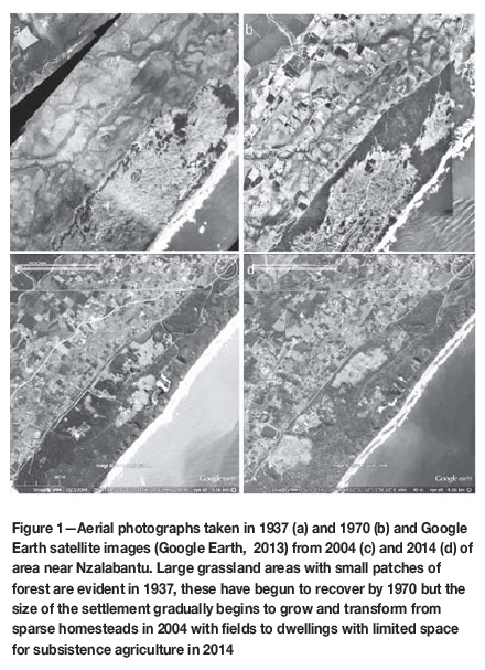
The advent of a mining development in the heart of rural Zululand attracted people from across the country in search of jobs, quickly swelling the rural population. Furthermore, the development of social responsibility programmes set up by the company improved infrastructure and services and lured more people to the area. This influx of people from other areas has resulted in gradual densification (Figure 1) and a dilution of local tradition and culture. Superimposed on other socio-economic challenges as experienced elsewhere in the province and the country, such as HIV/AIDS and unexpected price increments (see Knight et al., 2014), challenges in education, and youth unemployment have rendered the area increasingly difficult for tribal authorities to govern. The youth of the area have increasingly become involved in hunting with dogs as a sport, rather than a livelihood, and when combined with snaring, this has major impacts on the relatively low densities of mammals and ground-dwelling birds typical of coastal dune forests.
Food security (see Walsh and van Rooyen, 2015) and natural resources have become increasingly threatened, as in many cases areas previously used to raise crops for homesteads have either been sold as plots or converted into flats for immigrants (personal observation). In this way, low-density rural areas have gradually been transformed into peri-urban settlements. As the area comprises traditional tribal lands with limited government services, the remaining biodiversity of the area has further deteriorated and competition for jobs and land has intensified. In some locations, this has resulted in irresponsible land stewardship. For example, houses are erected in low-lying and temporarily dry wetland areas, while swamp forests are transformed into sugarcane fields, and lake edges are planted with timber lots (personal observation). These are often damaged after rain when the water table recovers, but the impacts on sensitive biologically diverse habitats such as wetlands and swamp forests are irreversible.
Small-grower plantations adjacent to the mining lease area have increased - a pattern mirrored in communal lands across KwaZulu-Natal, where plantations have increased relative to privately owned lands since 2005 (Jewitt et al., 2015). These plantations are not properly managed according to commercial forestry best-practice, and are often planted too densely, full of brush, overrun by noxious weeds, and not separated by firebreaks. Apart from the direct habitat and biodiversity losses associated with the expansion of plantations into natural lands, the poor management of these plantations constitutes a major fire hazard in the area, endangering people's lives as well as surrounding natural vegetation. This poorly-organized afforestation has drastically reduced traditional grazing lands and forced herders to move cattle into coastal forests. The subsequent unselective browsing and trampling by cattle is hampering forest regeneration as it prevents climax forest species from replacing pioneer Acacia kosiensis woodland (personal observation, but see Wassenaar and van Aarde, 2001).
Building sustainability
RBM has opted to restore coastal dune forest on the dunes remediated after mining, rather than simply replacing what natural vegetation still existed prior to mining. RBM has been initiating ecological succession on a continuous basis since the onset of mining four decades ago. More than 20 years of ecological research and monitoring has tracked the progress of forest regeneration (see http://www.ceru.up.ac.za/restoration/index.php). Independent, peer-reviewed scientific assessment has indicated that the natural vegetation restoration programme is successful as coastal dune forest species typical of the region gradually re-establish within these forests (Grainger and van Aarde, 2012; Wassenaar et al., 2005). However, direct disturbances (through increased demand for natural resources such as wood, medicinal plants, and animal products, transformation of forest and swamp forest to timber and sugar plantations) or indirect disturbances (through hunting, lack of influence over land allocation, increased livestock impacts) are increasing as a result of the challenges listed above, and the current drought conditions further compound the impacts. Developing solutions to the root cause of these concerns is the only way to ensure a sustainable landscape can be maintained for future generations.
Current programmes to improve land stewardship
RBM is committed to ensuring that it ultimately has a positive impact on the socio-economics and biodiversity of the area and a range of projects have been identified to achieve this goal by improving sustainability. Disturbances to the regenerating forests are a result of the relatively sudden influx of people, coupled with a decrease in control by tribal councils, which has led to land access and tenure concerns. An unstable social fabric, with an increasing number of unemployed youth dependent on the mine's interventions and assistance, results in the environment no longer featuring as a key concern for local communities. This could be partially attributed to lack of education, particularly environmental education, to demonstrate the importance of land stewardship for sustainability. This is a concern, given that rural communities are often most reliant on the services provided by relatively intact ecosystems (see Jewitt et al., 2015). Responsible land use that is sustainable can only be a product of socio-economic needs and an understanding of land capability to foster sustainable practices. That is, conservation of biodiversity is possible only once these are catered for, or rather as an additional outcome of socio-economic improvement programmes if an integrated, collaborative approach is followed.
Recognizing that many social and labour plan initiatives throughout South Africa have made people dependent on companies, RBM introduced a local economic development (LED) programme in 2013 that develops local businesses to provide services to the company, as well as the greater Richards Bay area. A key success story here was the development and appointment of a community joint venture to carry out the rehabilitation work for RBM. Here, not only the 60-strong workforce, but also the joint venture owners, are from the host communities. In addition, a team of 14 'cattle guards' are employed from the local community to minimize the impact of cattle on the regenerating areas by physically herding cattle from sensitive areas, and engaging with cattle owners to share reasoning behind this herding. In addition, this team was professionally trained to fight bush fires - a skill that showed its value during the recent drought. Aside from using local business enterprises, these projects have led to a sense of ownership of the regenerating forest and a transfer of ecological and environmental skills. These people have become ambassadors of land stewardship -sharing the importance of the regenerating forests within their own communities and therefore assisting to reduce the incidence of other threats (e.g. cattle in forests, weed infestation, hunting with dogs, snaring, and bush fires).
Another LED programme aims specifically at developing small-scale farming initiatives. This programme was designed to encourage and reward participation and has been very successful, with some farmers already producing a surplus of food (Rylance, 2014). The company is investigating the possible expansion of the agricultural programme into the areas on-lease currently used for Casuarina sp. plantations with the goal of providing agricultural development opportunities while teaching communities how to be better land stewards. Such a programme could be homestead-based (each homestead managing a portion of the land), but operate as a cooperative for activities like land preparation, planting, and harvesting to improve economies of scale and provide access to markets. This programme will also attempt to develop sustainable cattle-grazing areas that are carefully maintained by communities, thus reducing impacts on regenerating areas. Furthermore, RBM is looking into partnerships with the forestry sector regarding training programmes to improve the management of forestry areas both outside and within the mining leases.
Partnerships to inspire land stewardship
In partnership with other organizations, RBM embarked on an environmental education programme in 2013 aimed specifically at primary school children in host communities. Environmental awareness is gradually developed through a variety of events and lessons, including coastal clean-ups, Arbour Day, water awareness, youth leadership development, and environmental clubs. The partnership with the Wildlife and Environment Society of South Africa (WESSA) allowed the company to introduce and facilitate the participation of ten primary schools within their host communities in the WESSA Eco-Schools programme in 2014. All of these schools achieved their bronze certificates, enabling them to proceed to year two of the programme, and nine entered year three.
In addition to its own weed control programmes, the mine facilitates the Wildlands Conservation Trust's 'Greenpreneurs' programme to remove invasive vegetation from large tracts of communal lands and then plant indigenous tree saplings grown by local community members in return for bartered goods. This programme specifically targets women- and child-run homes, and the tree-planting team is dominated by women from the local community.
RBM is also exploring opportunities to develop the regenerating forests as a community conservation area. Here the aim is to encourage these communities to participate in the EKZNW Biodiversity Stewardship or similar programme where they will reap the rewards of running the area as a community conservation and ecotourism initiative. Seeking independent financing for such a programme will also ensure that it will persist beyond the life of the RBM mine. The forests and the biodiversity harboured therein must benefit the local communities in some way to ensure that they are paid to protect it, elsewise it will be transformed into another land cover perceived to provide better returns.
Planning ahead for new projects
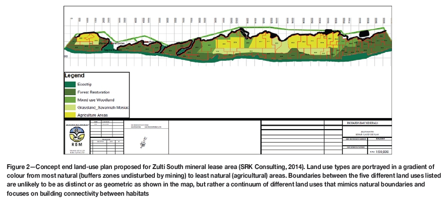
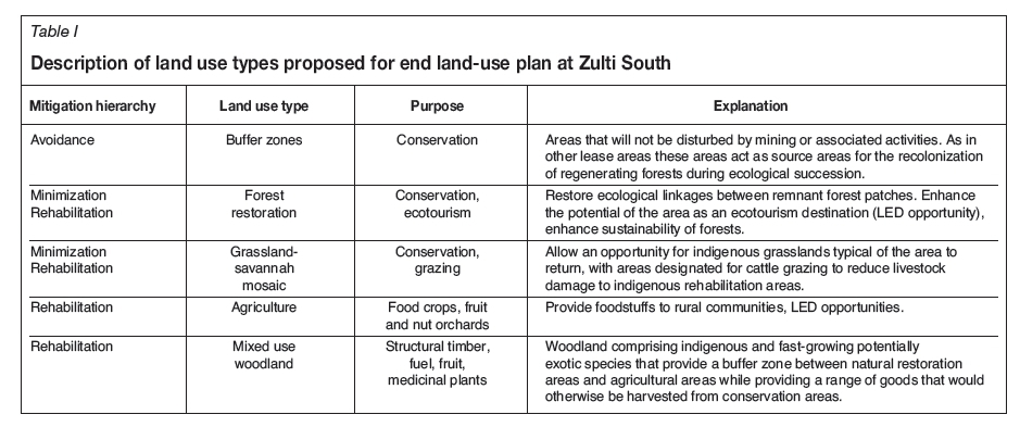
Many of the unintended socio-economic impacts of mining in rural area such as those summarized above could be avoided by government agencies providing a systemic approach to land use planning and management that the mining company can collaborate on. Expectations from different stakeholders are sometimes difficult to balance to generate a feasible, practical, and sustainable land use plan. Nevertheless, RBM is attempting to do this for its proposed project south of the Richards Bay harbour, through a plan that aims for good land stewardship throughout the life of the operation and long after closure. The company has developed an 'end land-use' plan to address the lessons learnt from its long-established northern mining lease. The company aims not only to restore ecologically sustainable coastal dune vegetation, but also to develop a land use mosaic that provides a range of ecological goods and services for the surrounding local communities (Figure 2). The plan makes provision for broad land use types with the objectives of facilitating the development of sustainable land uses within and outside the mining lease area; improving the ecological integrity of natural habitats by increasing the connectivity between forest fragments; rehabilitating degraded lands; and introducing sustainable land use practices that provide livelihoods for local communities after mining (see Table I)
This land use plan has been developed in conjunction with researchers involved in the baseline studies for the area, stakeholders such as the wildlife authority (EKZNW), and local communities by drawing on their knowledge of social and environmental concerns. Overlaying current land use with future mine plans, estimated topsoil distribution, and the planned conservation zones in a geographic information system has allowed RBM to design an end-land use mosaic that caters for agricultural zones in areas close to human settlements and builds ecological integrity by restoring forest adjacent to forest remnants that will not be mined. Transition zones cater for indigenous grasslands and mixed use woodlands, while also attempting to restore historical grasslands and provide grazing, which can act as buffer zones for regenerating forests. The conceptual land use plan has been subjected to the scrutiny of, and modified by, all stakeholders and has thus far been met with support. A recent assessment of current ecosystem goods and services compared to those provided by following this plan confirmed that the landscape mosaic described above would have a positive impact on the area's people and environment (Mander et al., 2014).
Societal changes and the impact on future land use
This plan may cater for the proximate needs of host communities; however, it should be acknowledged that these needs may change over time and that in the future, the focus may not be on subsistence livelihoods, but on more modern ways of life. It is by no means assumed that people will continue to use the land in the same way that they currently do. The increasingly peri-urban landscape inland of the coastal dune systems could therefore provide services for the greater Uthungulu District. For example, areas close to roads and villages may also present opportunities for energy generation and intensive food production (van Aarde and Guldemond, 2014) such as fish farming and hydroponics. Such alternative land uses are a viable option to create jobs and sustain livelihoods while adjacent coastal margin habitats are conserved.
Conclusion
The socio-economic challenges highlighted in this paper are common to many mines, but they become problems only if companies, communities, and government do not use the opportunity to learn from, and collaborate in solving, them. The inextricable links between the needs of people and the environment mean that a systemic approach to end land-use planning is crucial to facilitate the development of an environmentally and socially sustainable rehabilitated landscape. Critically, host communities and government agencies must gain an understanding of their role as stewards of the land and as conservators of biodiversity to avoid creating landscapes that constantly need to be rescued by outside intervention. An integrated land use plan that aims to rebuild ecosystem goods and services while also satisfying biodiversity goals sets the scene for achieving a positive impact on a region. Such a plan requires support from not only the private sector and the host community, but collaboration by government, wildlife authorities, the private sector, and NGOs.
References
Anderson, G. 1997. Archaeological surveys and excavations of the RBM mining lease. Report, Richards Bay Minerals, Umlando Archaeological Surveys. [ Links ]
Anderson, G. 2003. Archaeological survey of the Richards Bay Minerals Zulti North & Tisand Mining Leases. Report, Richards Bay Minerals, Institute for Cultural Resource Management, Natal Museum, Pietermaritzburg, South Africa. [ Links ]
ANDERSON, G. 2014 Umlando Archaeological Surveys. Personal Communication. [ Links ]
Cloete, J. and Marais, L. 2013. Labour, migration, settlement and mine closure in South Africa. Geography, vol. 98. pp. 77-84. [ Links ]
Department Of Environmental Affairs, Department Of Mineral Resources, Chamber Of Mines, South African Biodiversity Forum, and South African National Biodiveristy Institute. 2013. Mining and Biodiversity Guideline: Mainstreaming biodiversity into the mining sector. [ Links ]
Grainger, M. and van Aarde, R.J. 2012. Is succession-based management of coastal dune forest restoration valid? Ecological Restoration, vol. 30. pp. 200-208. [ Links ]
Google Earth. 2013. Nzalabantu, KwaZulu-Natal. 28°41'54" S 32°58'10" E, Eye alt. 4.06 km. Digital Globe 2015. http://www.earth.google.com [Accessed16 January, 2015]. [ Links ]
Hamman, M. 2016. Exploring connections in socio-ecological systems: The links between biodiversity, ecosystem services and human well-being in South Africa. PhD thesis, Stockholm University. [ Links ]
Jewitt, D., Goodman, P.S., Erasmus, B.F.N., O'Connor, T.G., and Wittkowski, E.T.F. 2015. Systematic land-cover change in KwaZulu-Natal, South Africa: Implications for biodiversity. South African Journal of Science, vol. 111. http://dx.doi.org/10.17159/sajs.2015/20150019 [ Links ]
Knight, L., Roberts, B.J., Aber, J.L., Richter, L., and the Size Research Group. 2014. Household shocks and coping strategies in rural and peri-urban South Africa: Baseline data from the size study in KwaZulu-Natal, South Africa. Journal of International Development. DOI: 10.1002/jid.2993 [ Links ]
Leonard, L. 2016. Mining and/or tourism development for job creation and sustainability in Dullstroom, Mpumalanga. Local Economy, vol. 31. pp. 249-263. [ Links ]
Mander, M., Van Niekerk, M., De Winnaar, G., and Browne, M. 2014. Ecofutures Zulti South Project, Richards Bay Mining (RBM). Report no. 28, Future Works Sustainability Consulting, Knysna, South Africa. [ Links ]
Manuel, J., Maze, K., Driver, M., Stephens, A., Botts, E., Parker, A., Tau, M., Dini, J., Holness, S., and Nel, J. 2016. Key ingredients, challenges and lessons from biodiversity mainstreaming in South Africa: people, products, process. OECD Environment Working Papers no. 107. OECD Publishing, Paris. [ Links ]
Marwick, C.W. 1973. Kwamahlati -the story of forestry in Zululand. Department of Forestry Bulletin, vol. 49. Government Printer, Pretoria, South Africa. [ Links ]
Olivier, P.I., Van Aarde, R.J., and Lombard, A.T. 2013. The use of habitat suitability models and species-area relationships to predict extinction debts in coastal dunes forests, South Africa. Diversity & Distributions, vol. 19. pp. 1353-1365. [ Links ]
Ott, T. 2013. The response of biological communities to spatial and temporal changes in a regenerating coastal dune forest along the north-east coast of South Africa. PhD thesis, University of Pretoria, South Africa. [ Links ]
Rylance, A. 2014. Richards Bay Minerals support to community development through agriculture. Final Report, German Development Cooperation (GIZ). [ Links ]
SRK Consulting. 2014. Richards Bay Mining Zulti South Mining Lease Area FEIAR. SRK Consulting, Durban, South Africa. [ Links ]
Van Aarde, R.J. and Guldemond, R. 2014. Internal memo: End Land Use Plan for Zulti South: some conceptual ideas. Conservation Ecology Research Unit, University of Pretoria. [ Links ]
Wassenaar, T.D., van Aarde, R.J., Pimm, S.L., and Ferreira, S.M. 2005. Community convergence in disturbed subtropical dune forests. Ecology, vol. 86. pp. 655-666. [ Links ]
Wassenaar, T.D. and van Aarde, R.J. 2001. Short-term responses of rehabilitating coastal dune forest ground vegetation to livestock grazing. African Journal of Ecology, vol. 39. pp. 329-339. [ Links ]
Walsh, C.M. and van Rooyen, F.C. 2015. Household food security and hunger in rural and urban communities in the Free State Province, South Africa. Ecology of Food and Nutrition, vol. 54. pp. 118-137. [ Links ]
Weisser, P.J. and Marques, F. 1979. Gross vegetation changes in the dune area between Richards Bay and the Mfolozi River, 1937-1974. Bothalia, vol. 12. pp. 711-721. [ Links ]
White, F. and Moll, E.J. 1978. The Indian Ocean coastal belt. Biogeography and Ecology of Southern Africa. Werger, M.J.A. and van Bruggen, A.C. (eds). Springer, The Netherlands. pp. 563-598. [ Links ]
This paper was first presented at the Mining, Environment and Society Conference ‘Beyond sustainability - Building resilience’, 12–13 May 2015, Mintek, Randburg, South Africa.

