


Services on Demand
Article
 English (pdf)
 Article in xml format
 Article references
Indicators

Related links
-
 Cited by Google
 -
 Similars in Google
Share

 Permalink
Journal of the Southern African Institute of Mining and Metallurgy
On-line version ISSN 2411-9717
Print version ISSN 2225-6253
J. S. Afr. Inst. Min. Metall. vol.115 n.6 Johannesburg Jun. 2015
PLATINUM CONFERENCE PAPERS
Predicting the probability of Iron-Rich Ultramafic Pegmatite (IRUP) in the Merensky Reef at Lonmin's Karee Mine
D. Hoffmann; S. Plumb
Lonmin Geology, South Africa
SYNOPSIS
IRUP is an iron-rich ultramafic pegmatite rock that formed due to hot iron-rich fluids and gases replacing local stratigraphic zones of the Bushveld Complex. This study focuses on the estimation of the probability of IRUP occurrence on the Merensky Reef at the Marikana Karee Mine. A 2.15 million centare IRUP-rich domain at the Karee Mine was initially defined from the interpretation of a surface aeromagnetic anomaly, and exposures in the mine workings. Surface boreholes (spaced 250-500 m apart) within this IRUP domain contain approximately equal numbers of IRUP-replaced and IRUP-free intersections. Owing to the uncertainty in the continuity of the IRUP alteration (a result of the wide borehole spacing), the risk associated with the development of mining infrastructure within this domain is unquantifiable. Semi-quantitative data comprising visual estimates of IRUP replacement from reef development mapping data and surface borehole reef intersections was interpolated into blocks using indicator kriging estimation. Comparative analyses of the estimate of IRUP occurrences were made by changing the block size and declustering the data systematically. Reconciliations of the probability of IRUP predicted from the block models derived from the different data-sets and sequential indicator simulation models were analysed for four mining study blocks. A quantitative approach to modelling the occurrence of IRUP can be an additional tool for refining the estimate of the geological losses that inform the mine plan in such high-risk zones.
Keywords: geological losses, Merensky Reef, IRUP replacement, indication kriging
Introduction
IRUP is an iron-rich ultramafic pegmatite rock that occurs as discordant pipe-, vein-, or sheet-like bodies that formed subsequent to cumulate crystallization within the Bushveld Complex (Viljoen and Scoon, 1985). The occurrence of large IRUP zones in platinum mining operations result in changing reef conditions that adversely affect mining layouts and efficiency due to (i) variable strike of the reef associated with slumping of the strata, thus influencing haulage positioning, (ii) poor stope extraction where iron replacement on the reef horizon has obliterated the economic zone and redistributed part of the platinum group metal mineralization, and (iii) more complex processing conditions related to harder mill feed and poorer concentrator recoveries arising from the increased petrological variability of IRUP ore. At the Marikana Karee Mine, the current mine planning practice assigns a 100% geological loss to IRUP-affected Merensky Reef where there is no on-reef development, which effectively discounts approximately 1.4 million centares of mineral resources. A quantitative predictive model for the occurrence of IRUP ahead of mining would be useful since the geological loss discount value could be factored more proportionally to the risk associated with the estimated probability of IRUP occurrence.
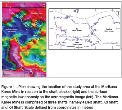
A conceptual study is presented in which geological information from three sources (aeromagnetic survey, surface borehole core logging, and underground mapping) is examined and used to predict the probability of IRUP occurrence ahead of mining at Karee (Figure 1). The approach was to establish a geostatistical estimate of the IRUP probability using ordinary kriging. The borehole and mapping source data, converted to categorical indicators, was interpolated into block models and compared to outcomes from multiple sets of declustered data. The objective being to reconcile models derived from widely-spaced data with a reference model based on all the data, and to comment on the change in the probability of IRUP occurrence in selected mining study blocks. A sequential indicator simulation model using only the surface borehole intersection data was also investigated to examine its suitability for predicting the probability of IRUP occurrence.
Geological setting
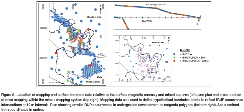
At Marikana, the IRUP-rich alteration zones on the reef horizons have diameters ranging from tens to hundreds of metres, and are often observed as conformable sheets below the UG2 Reef footwall contact, where replacement of the plagioclase-rich pegmatoidal pyroxenite unit occurs, or as a discordant replacement of the Merensky Reef pyroxenite unit. Due to the irregular nature of the IRUP, exposures seen in the footwall excavations do not always continue directly to the overlying reef, typically 20 m above. In the study area at the western part of the Karee Mine (Figure 1), the IRUP domain has an area of 2.15 million centares and occurs as an irregular north-south elongate zone that forms part of the Brakspruit Pipe described by Viljoen and Scoon (1985). Within the Lonmin mining right, the zone has dimensions of 2.7 km north-south and 1.7 km east-west based on the interpretation of an aeromagnetic anomaly. Along the north and northeastern margin of the aeromagnetic anomaly in the K3 Shaft block the occurrence of IRUP is closely correlated with the mining limit (Figure 1). Towards the east and southeast of the anomaly, mining has not advanced into the IRUP domain, and the distribution of IRUP will be tested as mining progresses within the 4 Belt Shaft block.
Surface borehole geological logging has revealed that within the aeromagnetic anomaly, five of the 16 boreholes on the reef horizon define a large core of IRUP towards the northeast. Detailed mining exposure in this area, however, reveals that this core is fragmented and consists of erratic lenses of iron-replaced pyroxenite (Figure 2) with larger areas of replacement towards the central zone. The areas along the remaining periphery of the aeromagnetic anomaly towards the north, west, and southwest were found to be mostly IRUP-free on the Merensky Reef horizon, based on intersections from ten boreholes. It is within this zone of the aeromagnetic anomaly that the conundrum arises. Since in the exposures towards the east there is a good correlation of IRUP with the aeromagnetic anomaly, a similar high probability of IRUP occurrence would be expected towards the west; however, the surface borehole intersection data indicates a low probability of IRUP occurrence in these unmined areas.
Data preparation
In the underground developments, the location and continuity of the IRUP occurrence is well defined from mapping information. For the on-reef development, mapped IRUP alteration, where visible in significant proportions, has been used to define categorical indicators of IRUP occurrence. A pseudo-borehole data-set was compiled using the mapping data. The on-reef development mapping was divided into 10 m intervals and used to compile a database for the occurrence of IRUP (Figure 2). The actual percentage of IRUP exposed in the development was not determined, but a visual estimate was defined consisting of three categories, viz.: (1) no replacement with no visible IRUP, (2) partial replacement, <50% IRUP, and (3) strong replacement, 51-100% IRUP. The same categories were assigned to the surface boreholes for the mother hole only. These were then assigned values of 0, 50, and 100 respectively. In the variography data analyses and estimation block models, the 50 and 100 values were combined into a single category to reflect 'some' or 'full' occurrence of IRUP and assigned a value of one. The resulting categorical data-set represents two rock types, one with no observed IRUP and the other where IRUP may be present in varying proportions. A total of 3617 measured mapping points and 60 surface borehole points were used in the analysis.
Block model process
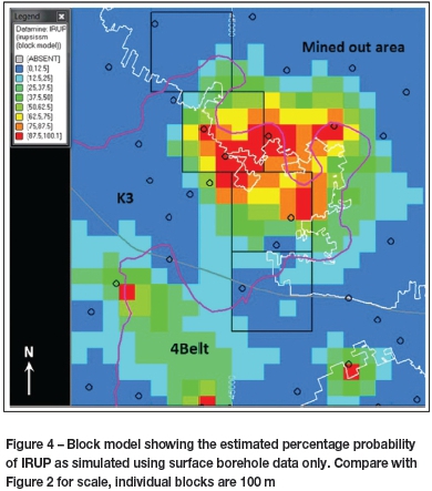
Block models reflecting an estimate of the probability of IRUP occurrence were constructed by interpolating the binary data of categorical values of 0 (no IRUP) and 1 (some IRUP) using ordinary kriging estimation. Deutsch (2006) suggests that the ordinary kriging method for indicators is a reasonable approach where local data is plentiful, and there is 'some evidence of non-stationarity areas'. Generally, stationarity was assumed within each categorical variable. The spatial analysis revealed non-anisotropy for the IRUP categorical data, and a spherical model was applied to the semivar-iogram, which had a range of 480 m at the normalized sill. The first search distance of 500 m for data selection was derived from the semivariogram range, and a second search distance of 1000 m was permitted to complete filling of the model. The sample numbers were set to a minimum of 5 and a maximum of 20. Block models using the total data-set were constructed for 50, 100, 250, and 500 m block sizes in the X and Y directions. The estimate of IRUP for the study domains was stable for block sizes <250 m; however, an increased divergence in the probability of IRUP occurrence was found for the 500 m blocks. A block size of 100 m was selected as the preferred size because of the closeness to the dimensions of the planned selective mining unit. Additional block models with 100 m block sizes were derived for the declustered data-sets with centres at intervals of 50, 100, 250, and 500 m. The data points in the declustering process were selected closest to the centre of the cell. Similarly, additional block models were constructed using only the surface borehole intersections. All the above block modelling was conducted using the Datamine software (Figure 3). Finally, a sequential indicator simulation block model using the 'BLOCKSIS' module in the GSLIB software suite (Deutsch, 2006) was used by applying the same estimation parameters for the surface borehole data. Here, 100 realizations were composited into a single model (Figure 4).
IRUP block models
The IRUP block model using the combined mapping and surface borehole data (called the Reference Model) honours the IRUP aeromagnetic outline within the K3 Shaft block for estimated IRUP probability values >25%. It conflicts, however, with a portion of the aeromagnetic anomaly towards the south within the 4 Belt Shaft block (Figure 3A). Here, the higher IRUP probability was influenced by sparse borehole spacing within the 4 Belt Shaft block, particularly between boreholes spaced 1000 m apart. The block model also reveals a core of higher IRUP probability for the K3 Shaft block, which lies within a NE-SW trending ellipsoid of lower IRUP probability. Where the IRUP probability is estimated at >62%, the block boundary coincides with the termination of mining where panel faces have been stopped due to excessive IRUP. By declustering the data to 100 m and 250 m centres, the NE-SW trend of the IRUP block model is maintained (Figure 3B and 3C). The higher IRUP probability core for 100 m declustered data continues to honour the aeromagnetic footprint. The declustered data block models have increased smoothing, which results in a more diffuse distribution of IRUP probability. In particular, the 250 m declustered data block model no longer exhibits the higher IRUP probability core.
An interesting pattern emerges for the surface borehole data block model, which reveals a well-developed concentric core of high IRUP probability with decreasing IRUP probability trending outwards (Figure 3D). Furthermore, the NE-SW trend is no longer developed. Where the estimated IRUP probability is >75% in the core, a close correlation with the aeromagnetic anomaly exists; however, it extends partially into the mined-out area. Comparison of this model with the simulated IRUP block model (Figure 4) reveals an expansion of the core and erroneous extension well beyond the mined-out contact towards the east beyond the aeromagnetic limit, thus overestimating the IRUP probability.
A distinctive low IRUP probability trend (NW-SE direction) evident in the Reference Model and 100 m declustered data block model (Figure 3A and 3B) has the effect of enclosing the IRUP core zone towards the west. This is due to the effect of four boreholes in this area exhibiting IRUP-free intersections and the absence of IRUP intersections on the reef horizon. This low-probability IRUP area becomes increasingly prominent in the block models based on surface borehole data only (Figure 3D and Figure 4), and predicts that the remaining part of the K3 Shaft block towards the mining right boundary will have a low probability of IRUP occurrence.
Reconciliation
The success of the IRUP prediction model rests on the closeness of the probability estimates using the surface borehole and declustered data models compared with the Reference Model (total data model). This was examined for four study blocks with dimensions 500 χ 500 m along the western mining levels of the K3 Shaft block (Figure 5). These mining study blocks were selected such that there was overlap into the areas of extensive on-reef development where there would be greatest confidence in the model. Each study block had varying proportions of stope extraction (Table I). Study blocks 1 and 4 (SB1, SB4) have low IRUP occurrence and a high stope extraction, whereas study block 2 (SB2) is divided into zones of high and low stope extraction due to the IRUP distribution, and study block 3 (SB3) has high IRUP occurrence and very low stope extraction.
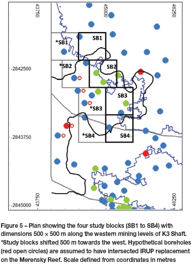
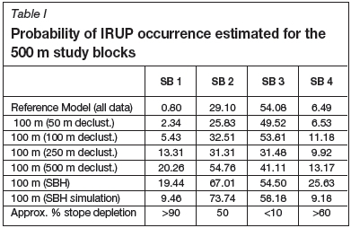
There is a close correspondence between the IRUP probabilities of the Reference Model and the models derived using 50 and 100 m declustered data (Table I). In contrast, the IRUP probability for the 250 m declustered data model has close estimates for SB2 and SB4, but grossly underestimates SB3 where there is a high probability of IRUP occurrence and concomitant poor stope extraction. Similarly, the 500 m declustered data significantly overestimates the IRUP probability in SB1 and SB2, where IRUP occurrence is low and medium, respectively, in the Reference Model. The surface borehole model consistently overestimates the probability of IRUP in SB1, SB2, and SB4 compared to the Reference Model, where the IRUP probability is low to medium. In contrast, it has a very close comparison for SB3, where IRUP probability is high. The surface borehole simulation model generally reported higher IRUP probabilities compared to the Reference Model, in particular for SB2, but has reasonable comparisons for SB1, SB3, and SB4.
These 500 m study blocks reveal a reasonable reconciliation for data spaced 100 m apart, and thus longer term mine planning could reasonably apply the IRUP probability as a discount factor. However, caution should be exercised when considering the IRUP probabilities for 250 m and 500 m spaced data, due to the variable and erratic nature of the alteration.
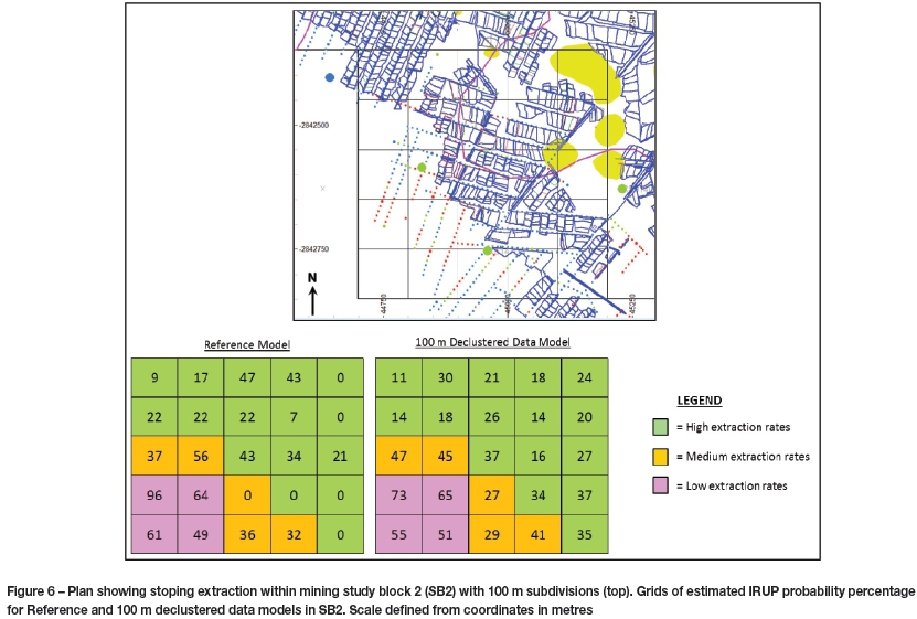
It is of interest to see if the 100 m declustered data IRUP block model can be used to predict a reliable local estimate of the IRUP occurrence. SB2 was selected for this exercise as the northeast part of the block has low IRUP occurrence and a high stope extraction, whereas the southwest part has high IRUP occurrence and the prospect of stope extraction is poor (Figure 6). SB2 was divided into 100 m block sizes, because this size coincides with the mining crosscut layout, where a decision could be made to suspend development pending the outcome of further drilling information. A good correlation for the estimated IRUP probability in the Reference Model and the 100 m declustered data model (Figure 6) is obtained for the subdivided 100 m blocks in SB2.
Discussion
The practice of assigning a 100% discount to the mineral resource for blocks outside the on-reef development in Merensky Reef IRUP domains requires discussion. This cautious approach is founded on the close correlation of IRUP occurrence with the aeromagnetic anomaly, and is further supported by the high rate of stope termination along its perimeter. However, the significant number of surface boreholes that are free of IRUP within the aeromagnetic anomaly suggests that there may be large continuous areas that are minimally affected by IRUP. Thus blocks for which the IRUP probability is estimated to be below a certain threshold may have reasonable prospects for extraction. In consideration of the mining study blocks, it would be an option to differentiate blocks that have an estimated probability of <50% IRUP from those with >50%. Blocks in the aeromagnetic anomaly with an estimated probability of <50%, such as SB2, were found to have a high stope extraction. Similar blocks could be considered to have a realistic prospect of extraction, albeit with an additional nominal geological loss, for example +5% or +10%. Blocks that have >50% probability of IRUP occurrence would continue to be fully discounted from the mineral resource as the prospects of stoping extraction remain poor. This approach is reasonable for model estimates based on closely spaced data, typically <100 m. In contrast, the results for widely spaced data reveal a different outcome. A similar examination of the surface boreholes with data spaced 250-500 m apart reveals that the models are unsuitable for local estimation of blocks 100 m in size.
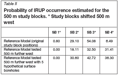
Testing the areas ahead of the mining study blocks (SB1-SB4) by querying the model 500 m further west of each block generally revealed a lower probability of IRUP occurrence. The study blocks SB2* and SB3* have significantly lower IRUP probability (Table II) due to their closer proximity to IRUP-free boreholes ahead of mining, whereas SB4* has a significantly higher IRUP probability due to a similar effect of a single IRUP-bearing borehole. To test the robustness of the model, five additional hypothetical surface boreholes were assumed to have intersected IRUP within the aeromagnetic anomaly. These boreholes were placed 100 m east of the IRUP-free borehole intersections and then remodelled. The new model reveals that the IRUP probability increases materially for the shifted study blocks in SB2*, SB3*, and SB4* (Table II). In particular, SB3* has a probability value of 43% and would likely be considered a target for further drilling, the outcome of which would confirm the decision to exclude it from future stoping. This demonstrates that the predicative model is sensitive to data volumes.
Limited attention was dedicated to the borehole block simulation model due to the poor correlation with the reference model. An approach to improve on the block simulation would be to use the aeromagnetic outline as a spatial reference. This would constrain the simulation to a known domain, thus assessing the IRUP probability within the aeromagnetic area.
Conclusions
➤ The aeromagnetic low anomaly associated with the occurrence of IRUP has been shown to be a useful tool to delineate the macro IRUP domain, which is associated with low stope extraction rates in the K3 Shaft block.
➤ The application of categorical indicators to estimate the occurrence of IRUP has revealed useful trends in the distribution of the IRUP probability. Block model kriged estimates of IRUP probability derived from mapping and surface borehole data at 50 m and 100 m intervals correlate well with the actual IRUP occurrence, which in turn can be correlated to the stoping extraction. In contrast, the IRUP probability for 250 m and 500 m spaced data may prove to be less reliable, due to the variable and erratic nature of the alteration.
➤ Estimated blocks in the aeromagnetic anomaly with a probability <50% of IRUP occurrence could be considered to have a realistic prospect of extraction. This threshold should be further tested. These blocks would likely carry an additional nominal geological loss for contingency. Blocks that have >50% probability of IRUP would continue to be fully discounted from the mineral resource, as the prospects of stoping extraction remain poor.
➤ A quantitative approach to modelling the occurrence of IRUP can provide an additional tool to refine the estimate of the geological losses that inform the long-term mine plan in such high-risk zones. This is work in progress and will be considered in the next planning cycle. Further testing of the simulation model by constraining the estimate to the aeromagnetic domain is a potential enhancement that could prove to be a more reliable predictor of IRUP occurrence.
Acknowledgements
The management of Lonmin Platinum is thanked for the opportunity and permission to publish this paper.
References
Deutsch, C.V. 2006. A sequential indicator simulation program for categorical variables with point and block data: BlockSIS. Computers and Geosciences, vol. 32. pp. 1669-1681. [ Links ]
Viljoen, M.J. and Scoon, R. 1985. The distribution and main geologic features of discordant bodies of iron-rich ultramafic pegmatite in the Bushveld Complex. Economic Geology, vol. 80. pp. 1109-1128. [ Links ]

