


Services on Demand
Article
 English (pdf)
 Article in xml format
 Article references
Indicators

Related links
-
 Cited by Google
 -
 Similars in Google
Share

 Permalink
Journal of the Southern African Institute of Mining and Metallurgy
On-line version ISSN 2411-9717
Print version ISSN 2225-6253
J. S. Afr. Inst. Min. Metall. vol.114 n.10 Johannesburg Oct. 2014
GENERAL PAPERS
The application of geophysics in South African coal mining and exploration
M. van SchoorI; C.J.S. FourieII
ICSIR, Natural Resources and the Environment, Pretoria, South Africa
IIEnvironmental Water and Geological Sciences Department, Faculty of Science, Tshwane Univerisity of Technology, Pretoria, South Africa
SYNOPSIS
Coal remains South Africa's most abundant and cheapest source of energy, and there is an ever-increasing necessity for optimal and safe extraction of the remaining reserves. Increasing focus on cost-effective mining and zero harm to the environment and miners has resulted in a shift in attitude towards the application of geophysics in local coal mining and exploration. Furthermore, technological advances have contributed to geophysics being embraced more readily by the coal mining industry, compared to a decade or two ago. Predictably, the growing interest in geophysical technologies has also created a need for education and training in the basic principles and application of geophysical methods, as local coal mining companies generally do not have in-house geophysicists. Consequently, the Coaltech Research Organisation's Geology and Geophysics working group forum compiled a textbook aimed at addressing this need: to produce a guide for applying geophysics to coal mining problems in South Africa. The target audience for such a book would be coal geologists, mine surveyors, mine planners, and other mining staff with limited or no geophysics background. This paper provides a very brief overview of the book by summarizing key sections and selected examples. In doing so, the value of geophysics to solving a range of coal mining and exploration problems is highlighted.
Keywords: geophysics, coal, old workings, dykes, sills, faults.
Overview of coal mining problems
Safe and efficient coal extraction is often compromised by a variety of geological and mining-induced problems. In this paper, we will focus on the five most commonly occurring problems and explain how the application of selected geophysical methods can play a key role in addressing these problems. The problems considered here are as follows:
► Delineation of old workings
► Near-surface cavity detection and evaluation of surface depressions
► Detection of intrusive dykes and sills (magnetic and non-magnetic)
► Structural and in-seam continuity disruptions (faults, lenses)
► Dolomitic pinnacles/uneven basement.
Delineation of old workings
In areas where mining encroaches on a previously mined area, the historic mine plans do not always provide accurate information regarding the extent of historic and existing developments. Mining into old workings may result in hazards such as flooding of advancing workings. The development of infrastructure over old workings may also be undesirable, especially in areas that are susceptible to surface subsidence. There is therefore a need for a non-invasive technology that can accurately delineate old workings.
Near-surface cavity detection
Old workings in previously mined areas commonly deteriorate over time and roof support pillars or beams fail. This may lead to subsidence or caving (also known as rat-holing) above the old workings. This caving may ultimately break through to the surface, or it could form undetected, near-surface cavities; either way, presenting a clear mining hazard.
Detection of intrusive dykes and sills
Intrusive dykes and sills impact adversely on the operational cost of coal extraction. These geological structures typically disrupt the continuity of coal seams and may also adversely affect the properties of coal seams that occur in close proximity to the intrusions (Du Plessis, 2008). Intrusive bodies typically constitute a relatively tough geological material, such as dolerite, which presents a great challenge for mining machines and can damage equipment. To complicate matters, the occurrence, geometry, and area of influence of intrusive bodies are difficult to predict ahead of mining, and unexpected intrusive bodies may negatively impact reserve and target estimates.
Structural and in-seam continuity disruptions (faults, lenses)
Geological faults disrupt and displace the seam horizon, which impacts adversely on production and mining due to the need to adapt or relocate workings. Regional-scale faults are often known in advance, but small mine- or metre-scale faults are often encountered only during active mining. Localized in-seam inclusions such as smaller dolerite intrusions and sandstone lenses also present a great challenge to early detection efforts because of their geometry. Such features may only be a few metres in diameter and they also typically do not have a linear trend or extend up towards the surface. The size-to-depth ratio of these features is relatively small, making them difficult to detect using conventional surface geophysical techniques, and in-mine or borehole-based geophysical methods may have to be used.
Dolomitic pinnacles/uneven basement
This problem occurs only where opencast mining activities are conducted in an area with a dolomitic basement that does not constitute a predictable, flat-lying horizon. Finger-like structures (pinnacles) that protrude upward and disrupt the lateral continuity of the overlying coal seams and slump structures (potholes) present extreme difficulties for mining due to the varying floor topography and the relative hardness of the dolomite (Lanham, 2004).
Geophysical applicability considerations
There are a number of factors that determine the applicability of a geophysical method to a given problem. These factors are:
► Physical property contrast (each geophysical method targets a different physical property)
► Range
► Required resolution (mapping accuracy)
► Geometry and scale of problem.
Property contrast
The fundamental requirement that governs the ability of any geophysical method to provide a solution is that there must be a detectable contrast in some physical property between the target and its surroundings (host rock) that can be exploited by geophysical measurements. For example, if the target is a subsurface void located in sedimentary rocks, the void will have a lower density and higher resistivity than the host rock. If, however, the void is filled with weathered material it may have a negligible density contrast with its surroundings, but then it may be relatively conductive compared to the host material.
Range
Every geophysical system will have a characteristic minimum detectable signal - below this level the system will essentially detect only noise. Furthermore, there is typically an inverse relationship between the recorded signal strength and the distance between the system and the target. The maximum possible distance between the system and the target of interest is known as the range. The range is determined by a variety of parameters such as the physical properties of the intervening rock mass and the type and properties of the source of the geophysical signal. As an illustration, at one extreme a high-frequency ground penetrating radar (GPR) system might provide a range of only a couple of metres, while at the other extreme, a reflection seismic system could achieve several hundred metres.
Required resolution (mapping accuracy)
Resolution technically refers to the smallest distance between two target objects for which the geophysical method can still discriminate between the two distinct objects. As with range, the resolution is determined by a variety of parameters, but primarily the characteristics of the sourced signal is important. As an example, wave-based methods (e.g. GPR) have a trade-off between range and resolution, which can be controlled to some extent through the operating frequency. Using a lower frequency increases the wavelength and lowers the signal attenuation. The result is a longer range, but at the cost of a decrease in resolution.
Geometry and scale of problem
Access to the survey area and proximity to the target play an important role in selecting possible geophysical solutions. Most traditional geophysical applications involve the taking of measurements on the surface. This approach is, however, not always good enough to achieve the desired depth of investigation and mapping accuracy. For this reason it is often necessary to exploit boreholes and underground developments to get closer to the geophysical target. Some geophysical methods also demand very specific or nonstandard survey geometries; for example cross-hole tomographic imaging technologies will require a pair of co-planar boreholes (or mining tunnels) that straddle the target zone. Borehole radar reflection surveys will require a single borehole drilled sub-parallel to a planar target horizon.
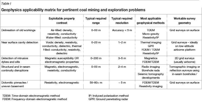
Based on the above considerations and requirements, and the coal problems described earlier, Table I shows the basic applicability guidelines for geophysical techniques.
Selected case studies
In this section, selected case studies, illustrating the applicability of geophysics to the previously described problem scenarios, are presented.
Delineation of old workings
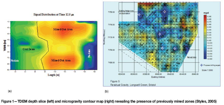
Old workings are often filled with mine water, which results in a relatively high bulk electrical conductivity compared to the virgin coal. This contrast in conductivity can be exploited by the TDEM method as illustrated in Figure 1a. This trial survey was done over a known old workings boundary, and the TDEM depth slice clearly shows the cross-over from relatively resistive virgin coal (cold colours) to conductive water-filled workings (orange-red), located at a depth of just over 30 m.
Figure 1b illustrates the application of the microgravity method to the delineation of old workings. This example is from a coalfield in the UK; the blue polygons indicate zones of contrasting (low) gravity. Subsequent drilling confirmed the correlation between these low gravity anomalies and air-filled old workings occurring at a depth of approximately 12-14 m.
Near-surface cavity detection
Figure 2a shows the result of a ground FDEM survey conducted over an area where a known abandoned mine shaft was buried under spoils. The EM-31 grid survey clearly imaged the highly resistive (low-conductivity) anomaly associated with the buried void. In cases where the suspected cavities are shallow and the overburden is not too conductive, GPR would arguably be the solution of choice because the method lends itself to fast data acquisition rates. Figure 2b shows an example from a Chinese coalfield where GPR was used to successfully detect previously mined-out zones as well as 'rat-holing' caused by such mining cavities. It should be noted that at many local sites affected by near-surface cavities, safety considerations may dictate that any geophysical surveying should be done from aerial platforms rather than by ground surveys,. However, it is technically fairly challenging to conduct high-resolution surveys at fine enough line and station spacings and at low enough altitudes in order to achieve the required metre-scale resolution.
Detection of intrusive dykes and sills
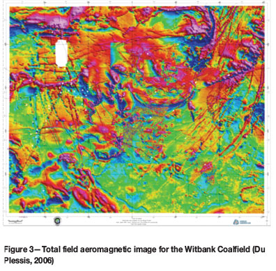
The value of airborne magnetic and EM methods is well known for the mapping of regional-scale structures. The example presented in Figure 3 is the result of a Coaltech Research Organisation project that was aimed at merging all available aeromagnetic data-sets for the Witbank Coalfield. Over 40 individual data-sets were merged and the output was used to perform lineament (dyke) and fault interpretations.
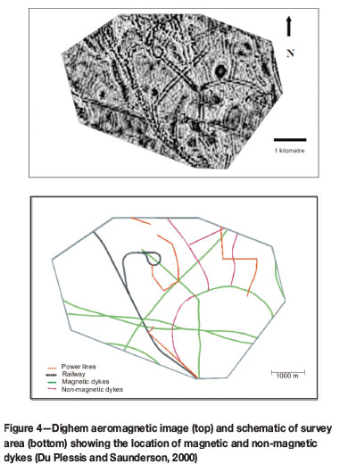
While airborne magnetics is generally well suited to detecting intrusions, the occurrence of non-magnetic dykes in South African coalfields is well documented. In such cases one needs to resort to the airborne EM method. Figure 4 shows the result of a helicopter-based Dighem survey. The EM method succeeded in detecting most of the previously mapped magnetic dykes, as well as other dykes that were not evident on the corresponding magnetic image.
Structural and in-seam continuity disruptions
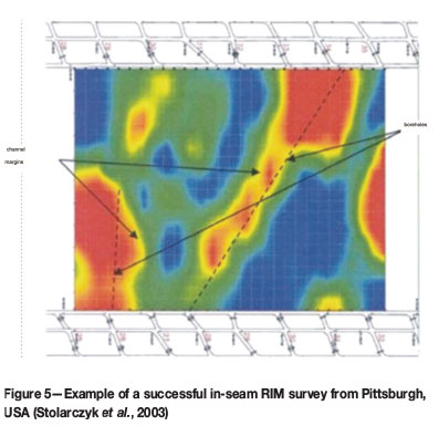
If it is possible to straddle a to-be-mined block with two lines of co-planar access; for example, two adjacent in-seam developments or boreholes, it is possible to apply a tomographic imaging approach to search for any localized seam disruptions. The example shown in Figure 5 is from a US coal mine where the radio imaging method (RIM) was successfully applied between developments to map the continuity of coal seams within longwall panels. The extent of sandstone palaeochannels in the coal seam ahead of mining could be inferred from the RIM survey results. Due to their relatively high conductivity the sandstone channels are associated with an increase in radio wave attenuation, and this is depicted by the warmer colours in the image.
Dolomitic pinnacles/uneven basement
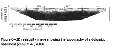
The final case study example relates to the mapping of uneven floor conditions - typically associated with dolomitic basement structures. Unweathered dolomite usually has a relatively high electrical resistivity compared to overlying shale, coal, and sandstone layers. Variations in the floor topography such as pinnacles and depressions can be imaged using either the EM or resistivity method. Figure 6 shows an example of the application of the 2D electrical resistance tomography (ERT) method to this type of problem. It should be noted that the mapping accuracy of the surface through the ERT method decreases with increasing depth, and for deeper basements it may be better to resort to the TDEM method.
Conclusions and recommendations
Geophysics can play a significant role in addressing a wide range of coal mining and exploration problems. The primary advantage of using geophysics is that it often provides a noninvasive way of obtaining quantitative information about the subsurface geological structure and of potentially hazardous ground conditions. The application of geophysics can thus contribute to optimizing extraction and to mining safety: well-planned geophysical surveys can provide advance warning of any deviations from the anticipated coal seam continuity and of any geological or secondary features that may constitute a production or safety hazard. However, to extracting maximum useful information from geophysical surveys it is essential to select the most appropriate method to apply to a given problem, as each method has its own strengths, weaknesses, and niche applications.
Finally, it should be noted that significant advances are continually made in various geophysical technologies. For example, enhancements in electronics, computer hardware, and software algorithms have enabled the acquisition and processing of significantly larger data-sets at much higher productivity rates and with better accuracies than was possible a decade or two ago. Consequently, advanced techniques such as 3D data acquisition and 3D forward/inverse modelling have become reality. It is therefore strongly advocated that coal industry practitioners remain up-to-date with the latest developments in geophysical research and development; this knowledge will aid them in the optimal selection and application of geophysical methods.
References
Donnelly, L.J. and McCann, D.M. 2000. The location of abandoned mine workings using thermal techniques. Engineering Geology, vol. 57. pp. 39-52. [ Links ]
Du Plessis, G.P. 2008. The relationship between geological structures and dolerite intrusions in the Witbank Highveld coalfield, South Africa. MSc thesis, University of the Free State, Bloemfontein. [ Links ]
Du Plessis, S.J. 2006. The merging of the aeromagnetic data of the Witbank Coalfield. Coaltech Research Association, Johannesburg. [ Links ]
Du Plessis, S.J. and Saunderson, R.D. 2000. The successful prediction of nonmagnetic dykes using a Dighem survey. Coal Indaba, Johannesburg, 15-16 November 2000. Fossil Fuel Foundation, Johannesburg. [ Links ]
Hu, M-S., Pan, D-M., Dong, S-H., and Li, J-J. 2012. GPR response characteristics of shallow loose coal seam. Geophysical and Geochemical Exploration, vol. 36, no. 4. pp. 599-606. [ Links ]
Lanham, A. 2004. New Vaal gears up to meet power demand. Mining Weekly, 3 September 2004. http://www.miningweekly.com/print-version/new-vaal-gears-up-to-meet-power-demand-2004-09-03 [ Links ]
Stolarczyk, L.G., Peng, S., and Luo, Y. 2003. Imaging ahead of mining with RIM-IV instrumentation and 3-D tomography software. 22nd International Conference on Ground Control in Mining, Morgantown, WV, 5-7 August 2003. [ Links ]
Styles, P. 2005. High resolution microgravity investigations for the detection and characterisation of subsidence associated with abandoned coal, chalk and salt mines. Post-Mining 2005, Nancy, France. [ Links ]
Van Schoor, M. and Fourie, C.J.S. 2014 (eds.) (in press). A guide for applying geophysics to coal mining problems in South Africa. Randomstruik. Cape Town. [ Links ]
Zhou, W., Beck, B.F., and Stephenson, J.B. 2000. Reliability of dipole-dipole electrical resistivity tomography for defining depth to bedrock in covered karst terranes. Environmental Geology, vol. 39, no. 7. pp. 760-766. [ Links ]

