


Services on Demand
Article
 English (pdf)
 Article in xml format
 Article references
Indicators

Related links
-
 Cited by Google
 -
 Similars in Google
Share

 Permalink
Journal of the Southern African Institute of Mining and Metallurgy
On-line version ISSN 2411-9717
Print version ISSN 2225-6253
J. S. Afr. Inst. Min. Metall. vol.114 n.8 Johannesburg Aug. 2014
Iron oxide Cu-Au (IOCG) mineralizing systems: an example from northeastern Russia
A. KostinI; A. VedyaevII; G. RafatIII
IDiamond and Precious Metal Geology Institute, Siberian Branch of the Russian Academy of Sciences (DPMGISB RAS)
IILLC 'Alkon-Europe', Moscow Russia
IIIGeoConsult (Pty) Ltd, Duisburg, Germany
SYNOPSIS
GIS and multivariate geometric distribution have been used to predict the association of high-level intrusives with hydrothermal alteration related to iron oxide Cu-Au (IOCG) mineralizing systems. Several examples in the Russian northeast are presented in this paper. IOCG ore deposits can have enormous geological resources containing significant reserves of base, precious, and strategic metals, and hence are economically attractive targets for mineral exploration. To date, examples of this type of mineralization have not been reported from the northeastern area of Russia. The Tarinskiy ore cluster, located in Eastern Yakutia, shows brecciated altered rocks with sulphide and iron oxide cement, which is typical for IOCG mineralization of the iron oxide Cu-Au±U type. This cluster was formed near surface and is linked with the Rep-Yuruinskiy pluton. It has potential to host new world-class precious metal deposits in northeastern Russia
Keywords: GIS, multivariate, iron oxide, Au-U-Cu, IOCG, Tarinskiy, Yakutia.
Introduction
A fundamental problem of ore deposit geology is the prediction of and prospecting for new large-scale precious metals deposits. One type of these - the large group of iron oxide copper-gold (IOCG) hydrothermal ore deposits containing Cu, Au, ±Ag, ±U, ±REE, ±Bi, ±Co, ±Nb, ±P - has not yet been recognized in the Russian Far East (Figure 1), and the potential for discovery is currently unknown.
The recognition of IOGC deposit types began with the discovery of the giant Olympic Dam deposit in 1975 in Australia, which contains 2000 Mt at 1.1% Cu, 0.5 g/t Au, 4000 g/t U3O8, and 0.24 - 0.45% La + Ce (Roberts. and Hudson, 1983). This was followed in 1987 by La Candelaria in Chile (470 Mt at 0.95% Cu, 0.22 g/t Au, and 3.1 g/t Ag) (Marschik, Leveille, and Martin, 2000). Deposits are often characterized by more than 20 modal per cent of iron oxides and a low content of sulphides. IOCG orebodies are typically linked with large mantle-type granitic intrusions, are breccia-hosted, and are located either proximal or distal to the granitic plutons.
IOCG deposits related to alkali and calcalkali plutons can also be associated with porphyry-type Cu-Mo or Cu-Au deposits, Cu-Ag 'mantle' deposites, U, haematite, and Au-PGE and polymetallic Pb-Zn-Ag ±Au veins (Corriveau, 2007; Gandhi, 2004).
Since IOCG mineralization is characterized by heterogeneity of both ore and metals, the application of new methods such as multidimensional geometric distribution using GIS and multivariate distribution of deposits should be very promising as a guide to exploration. Classical sub-soil geometry as a method of mathematical mapping spatial distribution of single elements can lead, in the case of complex deposits, to a situation where each element has its own geometry, i.e. the outlines of anomalies of various indicators do not coincide. This reduces the reliability of any assessment because of errors in determining the type of mineralization and incorrect evaluations of metal inventory. Therefore, it was necessary to develop a multidimensional model of geometric distribution of mineralization, which delineates homogeneous areas of a prospect by all elements simultaneously, thus excluding the ambiguity in the construction of the boundaries (Wedjaev, Wedjaeva, and Rafat, 2009). In addition, this model provides the best estimate of the average values of the parameters of the mineralized bodies (element contents, thickness etc.), which is ensured by a new solution for the statistical problem of multivariate distribution (Rodionov, 1981). This approach allowed the types of precious metal anomalies of East Yakutia, associated with IOCG mineralization, to be assessed with greater confidence.
Main features of known IOCG-type deposits
Hydrothermal features
All regions with IOCG deposits are characterized by large alteration halos, including Na (Ca) and K, ranging from 10 to 100 km2 or more (Barton and Johnson, 1996, 2004; Hitzman, Oreskes, and Einaudi, 1992). The alteration areas are usually of greater extent than the areas of IOCG mineralization (Gandhi, 2004). A key feature of IOCG deposits is the association with high-K granites (Pollard, 2000).
Mineralization
Economic mineralization is represented by chalcopyrite ± bornite and native gold, hosted by iron oxides. Haematite characterizes upper levels of the mineralizing systems, and magnetite the deeper levels.
Geophysical features
Sulphide-poor deposits with large volumes of Fe oxides and hydrothermal alteration form reasonable targets for regional airborne magnetic and gravity surveys (Kostin et al., 2006; Kostin, 2008). In combination with field geological observations, gravity and magnetic data are very useful, but expensive, tools in IOCG prospecting.
External features on Landsat images
Landsat multispectral data is one of the most powerful tools for exploring and characterizing many aspects of the Earth's surface, and is an inexpensive exploration method (Kostin, 2011, 2012; Kostin and Osipov, 2012). Spectral analysis using red (0.63-0.69 µm), green (0.52-0.60 µm), and blue (0.45-0.52 µm) is a true colour band (3-2-1) combination that allows areas with elevated concentrations of iron oxides to be distinguished (Figure 2).

Geological age
Geological age does not appear to be critical (Nisbet et al., 2000). IOCG deposits are known to occur from the Archean (Salobo and Igarapi Bahia) to the Mesozoic (Chilean Iron Belt, Russian Far East) (Requia et al., 2003; Sillitoe, 2003; Tallarico et al., 2004).
Prerequisites for IOCG-style mineralization in East Yakutia
A review of samples resulted in the identification of ore types that could be assigned to IOCG mineralization, but which were previously considered as a product of oxidation of sulphidic ores.
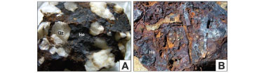
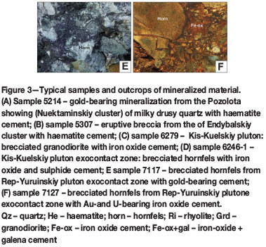
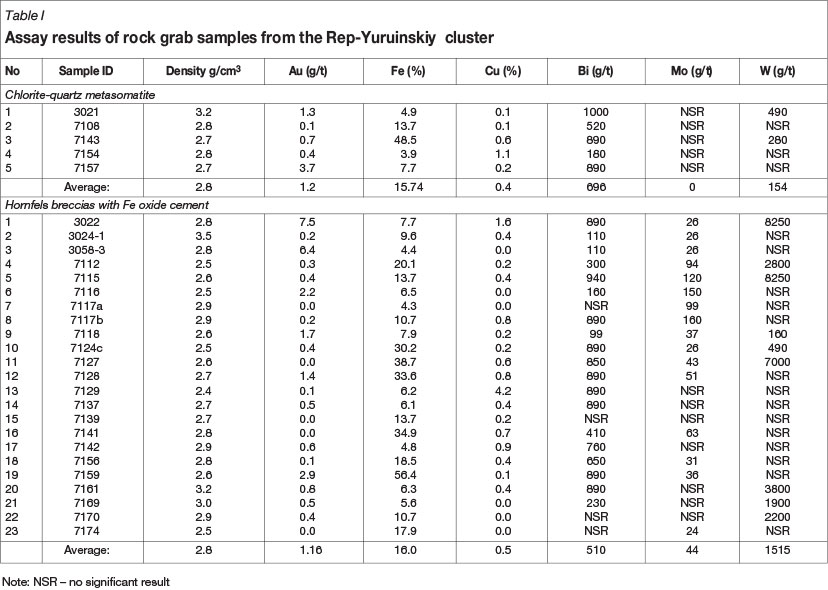
The Pozolota' zone (65.799669°N 129.596191°E) in the Nuektaminskiy cluster (Kostin et al., 2006) includes a 50 W 26 m stock-like body of milky drusy quartz with haematite cement and a gold content ranging from 1.2 to 19.8 g/t (Figure 3A). The field of the eruptive breccias of the Endybalskiy cluster (65.673781°N 130.132772°E) includes large bodies of breccia with goethite as cement. These were not analysed for copper and gold, but have a strong visual resemblance to IOCG mineralization (Figure 3B). The KisKuelskiy diorite-granodiorite intrusive (65.501242°N 130.280125°E) includes different types of IOCG-like mineralization (Kostin, 2010): brecciated granodiorite with iron oxide cement (Figure 3C) and brecciated hornfels with iron oxide and sulphide cement (Figure 3D). In the 2011 field season, one of the iron oxide anomalies identified in Landsat TM imagery was confirmed as IOCG-style mineralization. This anomaly is situated in the Rep-Yuruinskiy district (Tarynskiy cluster, 63.574957°N 143.275846°E) and is hosted by brecciated and metasomatized rocks. The Rep-Yuruinskiy sub-type of IOCG mineralization consists of granodiorite-associated, breccia-hosted bodies in which arsenopyrite mineralization is associated with iron oxide alteration of breccias (Figures 3E, 3F). The breccias include thick lenses of quartz-chlorite metasomatic lithologies with disseminated Cu sulphide mineralization. Breccia colour depends on the saturation of iron oxides, and changes in the supergene zone from dark brown to different shades of brown and yellow-brown. The breccias are commonly heterolithic and composed of sub-angular to rarely rounded lithic clasts or fine-grained massive material. The area of brecciation covers some 5 km2, while density varies from 2.41 to 3.23 (average = 2.76 t/m3). Hence, the resource potential could be about 712 Mt applying a depth of 50 m. The grab samples assay results are presented in Table I. Table II compares the Rep-Yuruinskiy occurrence with major worldwide IOCG-type deposits in terms of the resource and grade of mineralization.


Application of multivariate geometric distribution to enhance the reliability of assessment using the Rep-Yuruinskiy anomaly
The area of mineralization associated with the Verkhne-Chubukhulakhsky intrusive has been rock-chip sampled on a regular grid. The samples were crushed, pulverized, and analysed by atomic absorption spectrometry (AAS) for Au and by atomic emission spectrometry (AES) for Cu.
The results of geochemical sampling were tabulated in a Microsoft AccessTM database, which is connected by the function Join to the layer of geochemical sampling points. The key field for the connection is the geological number of the sample. The result is a system that uses the geostatistical analyst module for the interpolation of the surface by any element of the connected tables. Ordinary kriging is usually used for the interpolation method, by which means a surface for each element can be constructed.
It should be noted, however, that a single element may belong to various types of mineralization that may make up a deposit and determine its geological and industrial type. It is therefore difficult to characterize a deposit by the spatial distribution of a certain element. On the other hand, an attempt to divide a deposit into homogeneous areas in order to characterize its geometry also entails considerable difficulties, since the boundaries delineated by a single element may conflict with the boundaries built with the help of other elements (Rudenko and Vedyaev, 2009).
By contrast, the geometric distribution utilizes the full range of elements simultaneously, based on a probabilistic model of the mineralization and the new aggregated solution of the statistical problem by multivariate distribution (Rudenko nd Vedyaev, 2009). This eliminates not only the conflict between boundaries, but also allows, on the basis of the statistical characteristics of the homogeneous groups of observations obtained, the use of mineralogical and technological mapping to establish types of mineralization. This makes it possible, even at early stages of exploration, to recognize the geological-mining type of the prospect.
The multidimensional geometric distribution of mineralization of the Verkhne-Chubukhulakhsky intrusive was mapped with 19 elements using the software package AGATA (Figure 4). The average element contents of the main mineralization types are shown in Table III. The orientation of these types coincides with a series of small granitic intrusions.

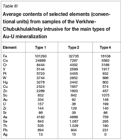
The following is a brief description of the mineralization types:
> Type 1 corresponds to the highest grades associated with Fe oxide breccia at the exocontact zone. In addition, this zone contains late-stage veins composed of arsenopyrite, wolframite, chalcopyrite, and sphalerite
> Type 2 is located in the mass of the brecciated hornfels and is characterized by initially low permeability to hydrothermal solutions, leading to low concentrations of Au and U
> Type 3 is associated with the outermost zone of the exocontact of the intrusive massif, passing into unaltered sandstone
> Type 4 corresponds to the outer brecciated zone of the exocontact, where Fe hydroxide cement is weakly developed and veins are absent. This type is characterized by the highest content of U.
Exploration model for Arc GIS analysis
IOCG-type deposits usually occur in the vicinity of porphyry Cu-Au or Cu-Mo deposits, associated with alkali and calcalcali plutons from A (anorogenic) to I (igneous) types, enriched with U, F, Mo, and REE (Corriveau, 2007). A-type granitoids are greatly enriched with Fe and comprise ferroan calc-alkali and alkali types, most of them being metaluminous. I-type granitoids are mostly calc-alkali or calcic and are of the magnesian type, while A-type granitoids are metaluminous, less often peraluminous (Frost et al., 2001).
The use of GIS to assess the potential of plutons plays an important role in the development of exploration models. Many deposits show a spatial relationship with plutons and this stimulates attempts to assess their potential for economic mineralization.
To date no exploration for IOCG deposits has been carried out in the territory of Eastern Yakutia, and the potential for this type of mineralization has not been discussed in the public domain. This paper represents the first attempt to assess the potential of the territory for IOCG-type mineralization.
For this purpose a GIS project was created, which includes:
> Basic geology with the location of plutons and their simplified geometry
> Geodatabase of major-element compositions of samples from the plutons (more than 4000 analyses)
> ArcGIS online service with 15 m eSAT images;
> Airborne magnetic data using a line spacing of 1 km.
The interpretation of Landsat images near plutons yielded a large number of areas with conspicuous colors indicating Fe oxides - from dark orange to reddish-brown (Kostin, 2011, 2012).
In the first phase of the investigation the prospective A-and I-type granitoids with Fe, Cu, Au, and U mineralization are recognized. These are then compared with the magnetic anomalies to guide further exploration.
In the second phase, the areas with elevated concentrations of Fe oxides are tested for their possible association with IOCG-type mineralization. Using the geodatabase of major-element compositions, samples from these areas are evaluated for their prospectivity for Fe, Cu, Au, and U mineralization.
Uranium
As exemplified by Australian deposits (Schofield, 2009), the major-element composition of rocks plays an important role in the behaviour of uranium. The highest uranium concentrations match to:
> ASI - U diagram: ASI index from 0.9 to 1.2
> (Na2O + K2O) / Al2O3 - U diagram: agpaicity index from 0.6 to 1.0.
Copper and gold
For the assessment of the potential of plutons for Au-Cu and Cu-Mo mineralization, data from Mongolian copper-porphyry deposits (Gerel, 1995) was used. A K2O/Na2O ratio ranging from 0.3 to 0.7 was established for Cu-Mo magmatic systems, while for Au-Cu systems the range increases to 0.7-1.3.
From the geodatabase, samples with Au-Cu mineralization were selected based on ratios of K2O/Na2O from 0.7 to 1.3 using the inquiry function of the database. Therefore, classification of the GIS band was made based on the feature pluton area, and the selected groups characterized by the extent of their erosional level.
In order to rank the number of prospects for Au-Cu mineralization, a filter has been used that selects plutons belonging to the high-potassium calc-alkaline and shoshonitic series.
The algorithm of the filter is based on formulae for the curves that describe the series of magmatic rocks in the diagram SiO2-K2O. The general form of the equation is K2O=k W SiO2 - b, and inquiries take the form of, e.g.:
> For rocks of the tholeiite series:
K2O < (0.033462 W [SiO2] - 1.5)
> For rocks of the calc-alkaline series:
K2O between (0.033462 W [SiO2] - 1.5) and (0.066507 × [SiO2] - 2.5)
> For rocks of the high-potassium calc-alkaline series:
K2O between (0.066507 W [SiO2] - 2.5) and (0.169054 × [SiO2] - 7.12)
> For rocks of the shoshonite series:
K2O > (0.169054 × [SiO2] - 7.12).
In addition to the inquiry using high-potassium calcalkaline series plutons, further conditions have been applied:
> Size of area < 5 km2
> K2O/Na2O ratio 0.3-0.7 (for Cu-Mo systems) and 0.7-1.3 (for Au-Cu systems).
GIS query results
The pluton analysis using three algorithms: ASI - U; (Na2O + K2O) / Al2O3 - U; and K2O / Na2O for U and Au-Cu mineralizing systems defined a common group of plutons with potential for Cu-Au-U mineralization, viz. Burgaliyskiy, Verkhne-Burgaliyskiy, Levo-Jolakagskiy, Verkhne-Tirekhtyakhskiy, Vostochno-Polousniy, Gornoe Ozero, Druza, Ilnimanskiy, Levo-Alaseiskiy, Magan-Tasskiy, Pravo-Tuostakhskiy, Takalkanskiy, Tarbagannakhskiy, Tommotskiy, and Elikchanskiy.
Using ArcGisOnline, the i-cubed 15 m eSAT images showed the presence of elevated concentrations of iron oxides in the vicinity of the Burgaliyskiy, Verkhne-Burgaliyskiy, Levo-Jolakagskiy, Verkhne-Tirekhtyakhskiy, Druza, Pravo-Tuostakhskiy, and Takalkanskiy plutons.
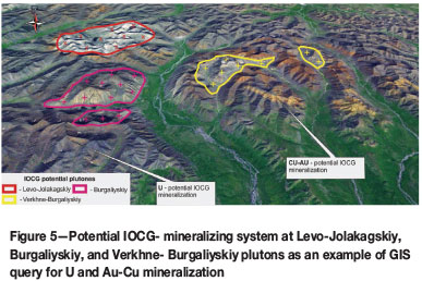
Large magmatic systems with IOCG potential may have three types of Fe oxide minerali-zation - directly at the contacts with the intrusive rocks (bright yellow shades), along the edge of plutons (dark yellow and brown tints), and in hornfels (dark brown) - this is seen at Levo-Jolakagskiy, Burgaliyskiy, and Verkhne-Burgaliyskiy plutons as an example (Figure 5).
Conclusions
> The data obtained suggests that mineralization ascribed to IOCG-type deposits is widely manifested in Eastern Yakutia (northeast of Russia), but its economic potential and geological features are unknown
> An exploration model for IOCG mineralization has been developed using GIS methodology to define plutons with higher prospectivity and associated mineralization
> The potential for IOCG mineralization is estimated to be very high. For example, the Verkhne-Burgaliyskiy pluton contains several areas of iron oxide mineralization. The largest is about 135 km2, which may yield an inventory of several billion tons of iron oxides. Even at low Au grades, this type of mineralization may be of economic interest
> A review of historic samples confirms the IOCG potential and a regional exploration model can be built. This may differ somewhat from the known analogues because of the geological history of Eastern Yakutia
> Based on the classification of IOCG mineralization the first discovery in Eastern Yakutia is an iron-oxide-rich breccia with Au-U-Cu(±Bi±Mo±W) mineralization. It is located at the roof of the calc-alkali/alkaline plutons, and is interpreted to correspond to a subtype of Olympic Dam (Australia)
> The use of multidimensional geometric distribution enhances the reliability of the assessment of mineralization type even at early stages of exploration with limited detailed data.
References
Barton, M.D. and Johnson, D.A. 1996. Evaporitic-source model for igneous-related Fe-oxide-(REE-Cu-Au-U) mineralization. Geology, vol. 24. pp. 259-262. [ Links ]
Barton, M.D. and Johnson, D.A. 2004. Footprints of Fe-oxide (-Cu-Au) systems. SEG2004. Predictive Mineral Discovery Under Cover. Centre for Global Metallogeny, University of Western Australia. Extended Abstracts, vol. 33. pp. 112-116. [ Links ]
Corriveau, L. 2007. Mineral deposits of Canada: iron oxide copper-gold Deposits: A Canadian Perspective. Mineral deposits of Canada: A Synthesis of Major Deposit-Types, District Metallogeny, the Evolution of Geological Provinces, and Exploration Methods. Goodfellow, W.D. Special Publication no. 5. Geological Association of Canada, Mineral Deposits Division. pp. 307-328. [ Links ]
Frost, B.R., Barnes, C.G., Collins, W.J., Arculus, R.J., Ellis, D.J., and Frost, C.D. 2001. A geochemical classification for granitic rocks. Journal of Petrology, vol. 42. pp. 2033-2048. [ Links ]
Gandhi, S.S. 2004. Magmatic-hydrothermal Fe oxide±Cu±Au deposits: classification for a digital database and an overview of selected districts. IAVCEI GeneralAssembly 2004, Pucsn, Chile. Ab-stracts01a_pt_169 [CD-ROM]. [ Links ]
Gerel, O. 1995. Mineral resources of the western part of the Mongol-Okhotsk foldbelt. Resource Geology, Special Issue 18. Ishihara, S. and Czamanske, G.K. (eds.). pp. 151-157. [ Links ]
Hitzman, M.W., Oreskes, N., and Einaudi, M.T. 1992. Geological characteristics and tectonic setting of Proterozoic iron oxide (Cu-U-Au-LREE) deposits. Precambrian Research, vol. 58. pp. 241-287. [ Links ]
Kostin, A.V., Goltsova, A.S., Lysenko, M.C., and Trufakina, T.V. 2006. Using GIS for prediction of noble-metalls ore deposits in Western Verhoyanie (Eastern Yakutia). Tikhookeanskaya Geologia, vol. 25 no. 5. pp. 62-72. [ Links ]
Kostin, A.V. 2008. GIS as a tool to estimate ore potential of intrusive formations of Verkhoyansky fold belt (Eastern Yakutia). Geologia, Poiski i Razvedka Rudnikh Iestorojdeniy. Izvestia Sibir-skogo Otdelenia. Sekcia Nauk o zemle RAEN, vol. 7, no. 33. pp. 97-105. [ Links ]
Kostin, A.V. 2010. Use of GIS-technologies for modeling endogenous zoning of Kis-Kuel skogo silver deposit based on the sampling results of the weathering crust (West Verhoan e, Yakutia). Placers and Weathered Rock Deposits: Modern Problems of Research and Development (PWR-2010). Apelsin Publishing, Novosibirsk, Russia. pp. 340-343. [ Links ]
Kostin, A.V. 2011. GIS as a tool for predicting of undiscovered mineral resources of silver. Geology, Tectonics and Metallogeny of North-Asian Craton. All-Russian Scientific Conference. Abstracts volume Yakutsk: IPK NEFU,- T.II. pp. 84-87. [ Links ]
Kostin, A.V. 2012. Undiscovered mineral resources and GIS: A new iron oxide coper gold (IOCG) deposit type in Eastern Yakutia with complex Au-U and Pt-Cu-Hg geochemical anomaly (Taryn-skiy ore node). Baikal International Conference: Geology of Mineral Deposits, Ulan-Ude, Enkhaluk on the Baikal. pp. 16-17. [ Links ]
Kostin, A.V. and Osipov, L.V. 2012. Undiscovered mineral resources and GIS: A new perspective complex Au-U and Pt-Cu-Hg geochemical anomaly of Rep-Yuruinskiy ore district (Tarinskiy ore node, Eastern Yakutia). Nauka i Obrazovanie, vol. 1, no. 65. pp. 55-59. [ Links ]
Marschik, R., Leveille, R.A., and Martin, W. 2000, La Candelaria and the Punta del Cobre district, Chile: early Cretaceous iron-oxide Cu-Au (-Zn-Ag) mineralization. Hydrothermal Iron Oxide Copper-Gold and Related Deposits: A Global Perspective, vol. 1. Porter, T.M. (ed.). PGC Publishing, Adelaide. pp. 163-175. [ Links ]
Nisbet, B., Cooke, J., Richards, M., and Williams C. 2000. Exploration for iron oxide copper gold deposits in Zambia and Sweden: comparison with the Australian experience. Hydrothermal Iron Oxide Copper-Gold and Related Deposits: A Global Perspective. vol. 1. Porter, T.M. (ed.). PGC Publishing, Adelaide. pp. 297-308. [ Links ]
Pollard, P.J. 2000. Evidence of a magmatic fluid source for iron oxide-Cu-Au mineralisation. Hydrothermal Iron Oxide Copper-Gold and Related Deposits: A Global Perspective. vol. 1. Porter, T.M. (ed.). PGC Publishing, Adelaide. pp. 27-41. [ Links ]
Requia, K., Stein, Η., Fontboti, L., and Chiaradia, M. 2003. Re-Os and Pb-Pb geochronology of the Archean Salobo iron oxide copper-gold deposit, Carajas mineral province, northern Brazil. Mineralium Deposita, vol. 38. pp. 727-738. [ Links ]
Roberts, D.E. and Hudson, G.R.T. 1983. The Olympic Dam copper-uranium-gold-silver deposit, Roxby Downs, South Australia. Economic Geology, vol. 78. pp. 799-822. [ Links ]
Rodionov, D. 1981. Statistical Solutions in Geology. Nedra, Moscow. 231 pp. [ Links ]
Rudenko, V. and Vedyaev, A. 2009. Multivariate model for geometrization of complex ore quality of Orlovsky deposit. Mining Information Analytical Bulletin, no. 9. pp. 123-129. [ Links ]
Schofield, A. 2009. Uranium content of igneous rocks of Australia. 1:5 000 000 maps - Explanatory notes and discussion. Geoscience Australia, record. 2009/17. 20 pp. [ Links ]
Sillitoe, R.H. 2003. Iron oxide-copper-gold deposits: an Andean view. Mineralium Deposita, vol. 38. pp. 787-812. [ Links ]
Sklyarov, E.I., Gladkochub, D.P., Donskaya, T.V., Ivanov, A.V., Letnikov, E.F., and Mironov, A.G.l. 2001. Interpretation of the geochemical data. Intermet Engineering, Moscow. 288 pp. [ Links ]
Tallarico, F.H.B., McNaughton, n.J., Groves, D.I., Fletcher, I.R., Figueiredo, B.R., Carvolho, J.B., Rego, J.L., and Nunes, A.R. 2004. Geological and SHRIMP II U-Pb constraints on the age and ori-gin of the Breves Cu-Au-(W-Bi-Sn) deposit, Carajas, Brazil. Mineralium Deposita, vol. 39. pp. 68-86. [ Links ]
Wedjaev, A., Wedjaeva, I., and Rafat, G. 2009. Neues Mehrdimensionales Verfahren zur Bewertung von Erzlagerstdtten. Statistisches Modell zur Geometrisierung von Bodenschdtzen. Technische Universitdt, Bergakademie Freiberg. Statusbericht 2008, Forschungsbeitrdge. Helft 2009-1. S. 301-314. [ Links ]

