


Services on Demand
Article
 English (pdf)
 Article in xml format
 Article references
Indicators

Related links
-
 Cited by Google
 -
 Similars in Google
Share

 Permalink
Yesterday and Today
On-line version ISSN 2309-9003
Print version ISSN 2223-0386
Y&T n.12 Vanderbijlpark Dec. 2014
HANDS-ON ARTICLES
Historic Environment Education - Vaal River tunnels: The forgotten history of the early days of coal in the Vereeniging area
Louisa Meyer; Johann Strauss
School of Education North-West University (Vaal Triangle) Johann.strauss@nwu.ac.za & louisa.meyer@nwu.ac.za
ABSTRACT
This article describes a part of the history of coal in the Vereeniging area which has, as far as could be determined, not been documented in detail before. Information was obtained from written primary and secondary as well as oral sources. In the article it is also explained how this content can be integrated into Social Sciences, History and Geography teaching as part of historic environment education.
Keywords: Historic environment; GW Stow; Tunnels; Discovery of coal; Time travel; Vaal River.
Introduction
The historic environment is an important teaching source that is often not integrated well enough in the teaching of history. According to Westergren (2006), the historic environment comprises of everything in the environment created by man. These historical sites could be 10 000, 1000, 100 or even one year old. Historic environment education is about life and societies of yesterday, today and in the future.
Local environment and local heritage are the starting points for historic environment education. Studying historic places and heritage gives learners a historic dimension and historic perspective. Teaching at historic sites gives a feeling of genuineness that heightens the experience (Westergren, 2006).
In the Vaal Triangle there are numerous places of historical interest and importance. This article discuss the tunnels that ran underneath the Vaal River in the Vereeniging area. This part of the history covers the period 1878 - 1914 (Leigh, 1968:16).
Early years of coal in the Vereeniging region
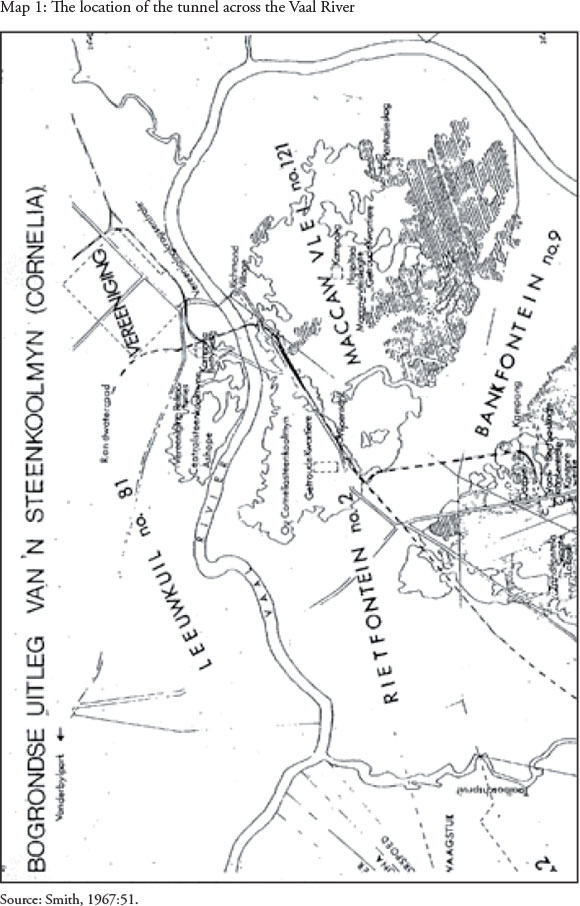
1. After the discovery of diamonds in the Kimberley region in 1866 the demand for coal increased. At first wood from the indigenous thorn trees in the region was used but this source was soon depleted. The Republic of the Orange Free State appointed George William Stow to search for coal (Smith, 1967:62). Stow discovered coal south of the Vaal River in 1878 (Leigh, 1968:112) in the region of the confluence of Taaiboschspruit and the Vaal River but the government of the Orange Free State did not regard it as valuable (Prinsloo, 1992:59). Samuel Marks, a prosperous Kimberley diamond magnate, heard of Stow's mineral investigations and discovery of coal in the Northern Orange Free State and adjoining Transvaal. This resulted in a meeting between them and the formation of a company called "De Zuid-Afrikaansche en Oranje Vrijstaatse Kolen en Mineralen Vereeniging". Stow was rewarded with shares in the company. The name of the company was too long and it was referred to as " De Vereeniging" by the man in the street and in 1892 the town was officially registered as Vereeniging (Smith, 1967:65). On behalf of the company Stow bought the farm Leeukuil in 1880 and Klipplaatdrift in 1881 (Leigh, 1968:21).
Marks wanted to transport the coal to Kimberley by means of flat bottomed boats (barges) on the Vaal River (Leigh, 1968:17). Coal was transported from the Central mine (See map number 1) to Kimberley and from 1892 by ox wagon to Johannesburg after the discovery of gold (1886). The first railway bridge across the Vaal River was built in 1892 and up till then ox wagons had to cross the Vaal River at the drifts. The best known of these drifts was Viljoensdrift. The first bridge across the Vaal River to link the Orange Free State with Transvaal was a wooden bridge that was opened by presidents Kruger (Transvaal) and Brandt (Orange Free State) on 20 May 1892. This also created a road from the Cape to Johannesburg. In November 1892 this bridge was replaced by a steel bridge (Centenary Brochure, 1992:7).
These two bridges were situated just north east of the current F W de Klerk bridge. Toll had to be paid to use the bridges which resulted in the transport of coal becoming expensive. After 1892 many transport drivers still transported coal from the Orange Free State to Transvaal (Gauteng) through the drifts (Centenary Brochure, 1992:4).
There were also other drifts through the Vaal River and other tunnels underneath the river. A local farmer had his own pont that could be used by transport drivers at a fee. The same farmer later dug a tunnel underneath the Vaal River but that collapsed (Milani, 2013). According to Leigh (1968:115) there were also tunnels underneath the Vaal River before the South African War (1899 - 1902) in the vicinity of the Viljoensdrift crossing, as well as one in 1905. Little information is available on the tunnels except that they were used to bring coal to the Transvaal side.
The width of the Vaal River varied according to the season and as a result it was more difficult to cross the river during the rainy summer season. During the winter months the width was approximately 15 meters and the depth less than 0.3 meters which made it possible to cross it by ox wagon (Centenary Brochure, 1992:4-7). During summer it was wider and deeper. According to statistics the width was between 70-80 meters at times and the depth two meters and even deeper at times (Leigh, 1968:28-29). A pont (26°42,28'S & 27°54,85'E) was also in use but once again the toll made the transport cost expensive. Viljoensdrift was situated at approximately 26°42,3'S & 27°55,2'E (Centenary Brochure, 1992:4).
The drift was just south of the present dumping site and approximately 3,2 km north of Viljoensdrift station, in other words very close to the Central coal mine. When the Vaal River Barrage Reservoir was built in 1923 the width of the river expanded (Roodt, 1982:9). Infiltration of water also increased due to the wider river. At present the width of the river is approximately 150 meters where it crosses the original tunnel (Google Earth, 2014).
The tunnels
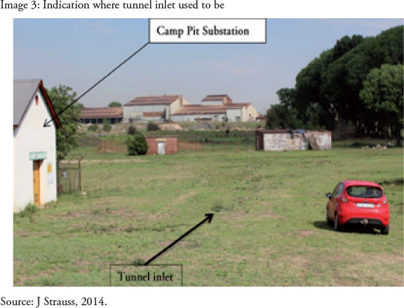
When the above-mentioned facts are taken into consideration, the digging of the tunnels makes sense. The first tunnel, built by the mining companies in 1913 started at the old Betty shaft of the Central East Coal mine (See map number 2). The entrance of the tunnel, known as Camp Pit (Leigh, 1968:116) was on the property of the "Brick and Tile Company or Vereeniging Refractories". The area now belongs to Meds Distribution (Cosmos). Camp Pit had one inlet but underground it divided into two. One tunnel let air in and out whilst the other tunnel transported coal from the Cornelia mine (Orange Free State) to Transvaal underneath the river by means of coco pans on a rail (See image 2).
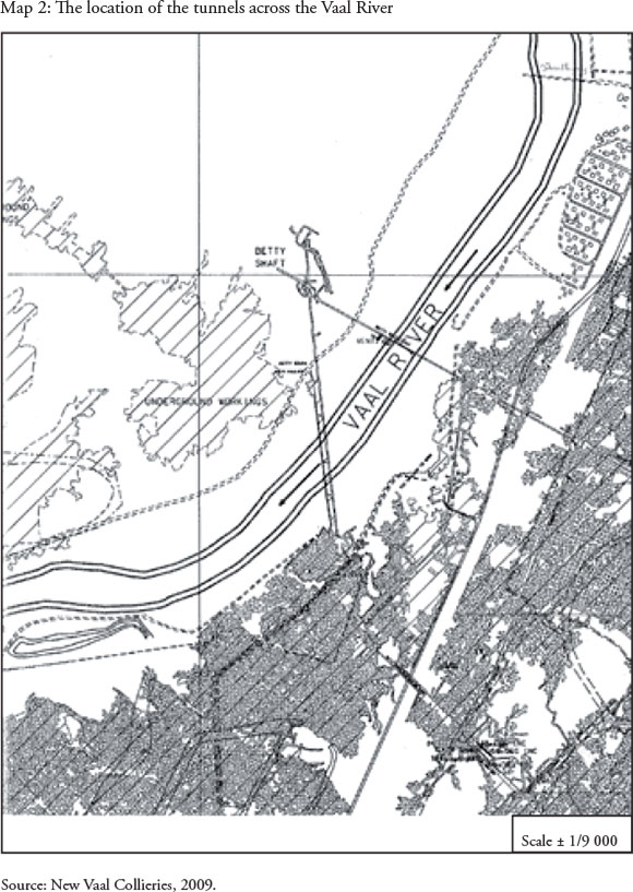
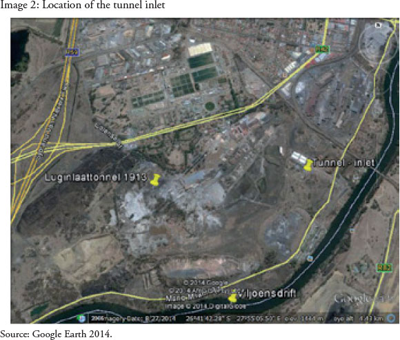
The coordinates of the tunnel inlet or incline shaft (Betty shaft) is 26°41, 7'S & 27°55,5'E, just east of the current building of the Camp Pit substation (See image 2 & image 1). Approximately 90 meters from the entrance of the incline shaft the tunnel split into two. The two tunnels split at an angle of 55°. The eastern tunnel served as air tunnel. The tunnel stretched for approximately 0,5 kilometers in an east-south-easterly direction underneath the Vaal River where it connected with the underground works of the Cornelia mine in the Orange Free State. The eastern tunnel crossed the Vaal River approximately 250m downstream of the present-day railway bridge. The coordinates of the tunnel-river crossing is approximately 26°41,8'S & 27°55,9'E (See map number 2)(RSA National Geo-spatial Information, 2010 & Knapton, 2014).
Coal from the Cornelia mine in the Orange Free State was transported via the southern tunnel underneath the Vaal River to the Central East Mine by coco pans on a rail (Knapton, 2014). The main reasons for transporting the coal via the tunnels to the Transvaal side were apparently the following:
ii. the high cost of toll;
iii. approximately 200 ton coal was needed every week for the gold mines in Johannesburg (Willemse,1999:32);
iv. the Central East mine was already exhausted in 1910 (Smith, 1967:66), and
v. the low quality ofcoal from the Central and Central East mines (Leigh,1968:116).
In 1913 Camp Pit was started in the immediate vicinity of the exploited Central East coal mine (Smith,1967:69). The entrance today is filled up and the original location of Camp Pit can be seen in image 2. The building to the west of the tunnel inlet as indicated on image 2 is today known as the Camp Pit substation (Dickerson, 2014).
General characteristics of the southern tunnel through which the coal was transported:
• Length - 991 meters.
• Width: at the entrance approximately 2,5 meters but deeper in 3,3 meters.
• Height: 2 meters and at the entrance 2,5 meters (Leigh,1968:116, confirmed by Knapton, Dickerson, Black & Grimbeeck, 2014).
• The tunnel was approximately 30 meters underneath the Vaal River (Leigh, 1968:116).
• Gradient: according to Smith (1967:77) coal layer ONE was mined in the Cornelia mine in the Orange Free State at a depth of 67 meters. The average gradient of the tunnel was thus 1:15. It therefore seems that the part of the tunnel closer to the entrance of Camp Pit/Central East coal mine was steeper than closer to the works section of the Cornelia mine (See image 3).
The tunnels were lined with cement and bricks to strengthen it and make it more waterproof. The tunnels later filled up with seepage of river water as well as flood water. In 1986 the tunnel was filled up with different kinds of material as a safety measure by Vereeniging Refractories (Knapton, 2014). Just before the closing of the tunnel the water level was about 30 m from the entrance. The content of the lime in the water was higher than that of the Vaal River but mr. Grimbeeck who tested the water on a regular basis, claimed that the water was in general cleaner than that of the Vaal River before the tunnel was closed. This could perhaps have been because of the seepage. Grimbeek also confirmed that the water level differed very little from one season to another.
Time travel to the tunnels as part of local history
Time travel can effectively be done in the Social Sciences, History and Geography classes. According to the Curriculum Assessment Policy Statement (CAPS ) of the Department of Basic Education (DBE), the specific aims of History are to create:
• an interest in and enjoyment of the past;
• the ability to undertake a process of historical enquiry based on skills, and
• an understanding of historical concepts, including historical sources and evidence (Department of Basic Education (DBE) 2011a).
One of the specific aims for Geography according to the DBE (2011b) is to understand the interaction between society and the natural environment.
Specific content topics related to this study for Social Sciences, according to the DBE (2011c), could be the following:
• Social Sciences, History, grade 5, A heritage trail through the provinces of South Africa;
• Social Sciences, History, Grade 8, The Mineral revolution in South Africa and
• Social Sciences, Geography, grade 5, Minerals and mining in South Africa.
By doing time travel in an historic environment, history and geography can become "alive" resulting in deeper insight, understanding and enjoyment. Places of historical importance in the Vaal Triangle are amongst others the Block House situated on the R59 north of Meyerton, rock art (Redan), the Vaal Teknorama museum, Constitution Square in the Vereeniging CBD, the Sharpeville memorial, the remainder of the tree trunk where the conditions for peace were negotiated after the second South African War, the sand stone kerbs in the Vereeniging CBD, Maccauvlei with the remaining pillars of the second bridge across the Vaal as well as a cemetery with the graves of the Australian and New Zealand soldiers who died in the second South African War, the bridge that was built in 1921 and is not used any more and the concentration camp cemetery. For this specific task only the tunnels that were used for the transportation of coal will be researched and the following steps will be applied:
• the theoretical part of the history will be dealt with in class;
• a complete assignment of the discovery of coal will be expected from the learners. Part of this assignment will be to arrange and conduct oral interviews with employees of the former "Brick and Tile Company or Vereeniging Refractories". The area now belongs to Meds Distribution (Cosmos);
• learners will be accompanied by the teachers on an excursion. Arrangements will be made to visit the following historical sites:
i. the local museum (Vaal Teknorama), to study the exhibition on the discovery of coal in the Vereeniging area; a representative of the museum will explain certain aspects and answer questions;
ii. the area where Vereeniging refractories was situated;
iii. Viljoensdrift where the pont used to be, and
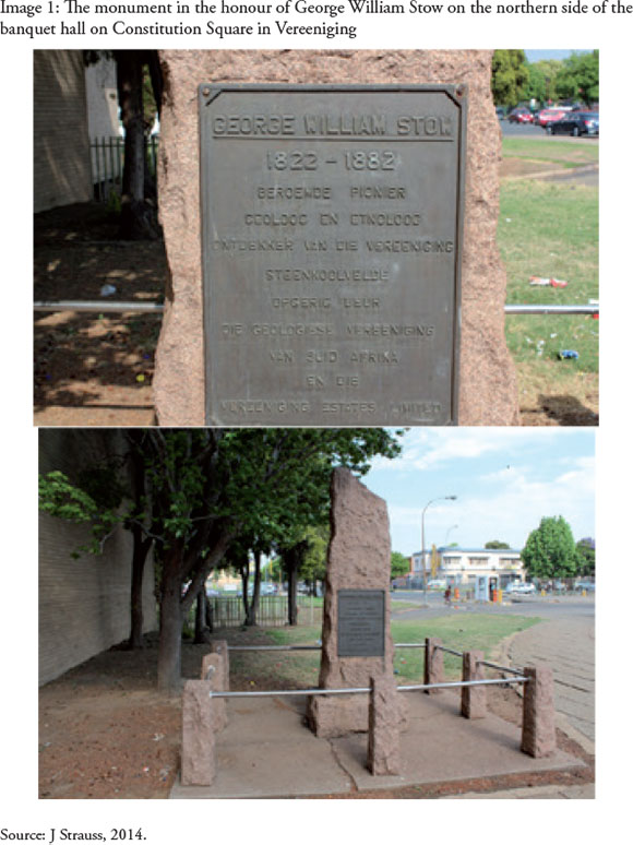
iv. a brief stop will be made at the monument of George William Stow which is situated next to the banquet hall on Constitution Square.
It will be expected from learners to take photos as technology is freely available and also to make notes. This, together with the information obtained from the interviews will enable them to submit and present a complete assignment on the role played by the Vaal River tunnels in the history of coal in the Vereeniging area. In conclusion the learners will be requested to evaluate the significance of the insight and creativity of the people of the time.
Conclusion
Time travel is an innovative and creative way ofimplementing the curriculum. It is envisaged that the learners will not only experience this "forgotten" part of environment history first hand, but it will enable them to make a link between theory and practice. It provides historic perspectives and it is fun.
History will become alive and that is, according to the authors, the essence of history teaching. The assignments of the learners will contribute to the data of tunnels underneath the Vaal River and as a result this history will not be forgotten.
References
Department Basic Education (DBE) 2011a. National Curriculum Statement, Curriculum and Assessment Policy Statement, Further Education and Training Phase, grades 10-12, Geography. Pretoria and Cape Town: Government Printing Works. [ Links ]
Department Basic Education (DBE) 2011b. National Curriculum Statement, Curriculum and Assessment Policy Statement, Further Education and Training Phase, grades 10-12, History. Pretoria and Cape Town: Government Printing Works. [ Links ]
Department Basic Education (DBE) 2011c. National Curriculum Statement, Curriculum and Assessment Policy Statement, Intermediate Phase, grades 4-6, Social Sciences. Pretoria and Cape Town: Government Printing Works. [ Links ]
Centenary Brochure 1992. The Vaal River Bridge and Vereeniging 1892-1992. Eeufees-brosjure. Vaal Teknorama. [ Links ]
Google Earth 2014. US Department of State Geographer@2014Google. Image Landsat. data SIO, NOAA, US Navy, NGA,GEBCO, 27 August 2014. [ Links ]
Leigh, RL 1968. Vereeniging. Suid-Afrika. 75ste Verjaarsdag van Vereeniging. Johannesburg: Courier-Gazette Publishers. [ Links ]
New Vaal Colleries 2009. Kaart van ondergrondse mynbou. [ Links ]
Personal interviews, Black R (current employee of Vereeniging Refractories), 2014. [ Links ]
Personal interview, Dickerson H (former employee of Vereeniging Refractories), 2014. [ Links ]
Personal interview, Grimbeeck J (current employee of Vereeniging Refractories), 2014. [ Links ]
Personal interview, Knapton J (geologist and current employee of Vereeniging Refractories), 2014. [ Links ]
Personal interview, Milani M (alderman of the City of Vereeniging), 2013. [ Links ]
Prinsloo, PJJ (red.) 1992. Die Geskiedenis van Vereeniging. PU vir CHO, Vanderbijlpark. [ Links ]
Roodt, JJ 1982. Vereeniging: Aansoek om groot-stad-status. Vereeniging: Ongepubliseerd. [ Links ]
RSA, National Geo-spatial Information. 2627 DB 18,19,29,23,24 &25.1/9 000. 2010. [ Links ]
Smith, MM 1967. 'n Geografiese studie van steenkool in die Vaaldriehoek (ongepubliseerde MA- verhandeling. UNISA. [ Links ])
Strauss, JPD 2014. Reseacher and photographer (one of the authors of this article), Vanderbijlpark. [ Links ]
Westergren, 2006. Kalmar County Museum. Available at ebbe.westergren kalmarlansmuseum. se. Accessed on 10 September 2014. [ Links ]
Willemse, M 1999. Die vestiging en uitbouing van die munisipale bestuur en voorstedelike ontwikkeling in Vereeniging tot 1992 (ongepubliseerde M.A.-verhandeling, PU vir CHO). [ Links ]

