


Servicios Personalizados
Articulo
 Inglés (pdf)
 Articulo en XML
 Referencias del artículo
Indicadores

Links relacionados
-
 Citado por Google
 -
 Similares en Google
Compartir

 Permalink
Water SA
versión On-line ISSN 1816-7950
versión impresa ISSN 0378-4738
Water SA vol.49 no.2 Pretoria abr. 2023
http://dx.doi.org/10.17159/wsa/2023.v49.i2.3992
RESEARCH PAPER
The use of stable isotopes to identify surface water-groundwater interaction in the Kruger National Park, South Africa
RM PetersenI, II; JM NelII; T StrydomI; E RiddellIII, V; C CoetseeI, VI; E FebruaryIV
IScientific Services, South African National Parks, Private Bag X402, Skukuza 1350, South Africa
IIEnvironmental and Water Science Unit, University of the Western Cape, Private Bag X17, Bellville 7530, South Africa
IIIConservation Management Services, South African National Parks, Private Bag X402, Skukuza 1350, South Africa
IVDepartment of Biological Sciences, University of Cape Town, HW Pearson Building, University Ave N, Rondebosch, Cape Town 7701, South Africa
VCentre for Water Resources Research, University of KwaZulu-Natal, Private Bag X01, Scottsville, Pietermaritzburg 3209, South Africa
VISchool of Natural Resource Management, Nelson Mandela University, George Campus, George, 6530
ABSTRACT
The role of groundwater, in general, is often overlooked in freshwater ecosystem management policies and in the management of South Africa's flagship conservation area, the Kruger National Park (KNP). To address this gap, a generalised conceptual model of surface water-ground water (sw-gw) interactions in the southern and central regions of the KNP was developed. To do this, stable isotope ratios (δ18O and δ2H) of groundwater, rainfall and surface water were used to determine the extent to which the base flow of perennial, seasonal and ephemeral streams on different geologies (granite vs. basalt) is driven by rainfall or groundwater. These results show that the δ180 and δ2H ratios of perennial rivers are similar to that of groundwater, while seasonal and ephemeral rivers on basalts have values closer to rainfall. On granite substrates, however, the isotope ratios of the seasonal and ephemeral rivers have values closer to groundwater than rainfall. The larger seasonal Mbyamiti River had similar isotope ratios to that of groundwater, and the highly ephemeral Nwaswitsontso had episodic interaction with groundwater (i.e. isotopic ratios overlap occasionally). These results show that decisions necessary for the sustainable management of groundwater resources are better informed when the natural interaction, movement, and exchange between groundwater and rivers are understood. This has particular relevance for large conservation areas in southern Africa that are expected to experience more variable climates in the future with both increases in drought and rainfall intensities.
Keywords: seasonal, ephemeral, perennial rivers, recharge, discharge, conceptual model, semi-arid
INTRODUCTION
Groundwater accounts for almost 90% of Earth's readily available freshwater yet, because it is out of sight, remains underappreciated and poorly managed (Jakeman et al., 2016). While global climate change models for southern African savannas predict no change in the amount of total rainfall received (Easterling et al., 2000; Frich et al., 2002; Pohl et al., 2017), the models also predict increases in rainfall intensity and increases in frequency and severity of droughts (Spinoni et al., 2014). Combined with these effects of more variable water supply are development pressures which are resulting in increased demands on previously unexploited aquifers (Mussá et al., 2015; Du Plessis, 2019). Increasing droughts and anthropogenic demands, paired with poor management of groundwater resources, have resulted in multiple problems across the globe. These include overexploitation which can result in land subsidence and declines in water table levels, with harmful effects on groundwater-dependent surface water systems (Vegter and Pitman, 2003; Wada et al., 2010; Wada et al., 2012; Wada and Heinrich, 2013). Monitoring and management decisions necessary for the sustainable utilisation of groundwater resources are better informed when the natural interaction, movement, and exchange between groundwater and rivers are understood (Glazer and Likens, 2012; Gleeson and Richter, 2018). In semi-arid ecosystems such as the Kruger National Park (KNP) (Newman et al., 2006), groundwater plays an important role in sustaining river baseflows and pools (Zektser and Loaiciga, 1993; Parsons, 2004; Hughes et al., 2007; Le Maitre and Colvin, 2008). Given this context, large conservation areas such as the KNP are important for understanding natural hydrogeological processes largely unaffected by anthropogenic activities. There is a total of 31 584 km of mostly second- or higher-order streams flowing across a west-east geological facies from granite to basalt in the park. These extensive drainage networks distribute water throughout the park and act as hotspots for biodiversity and productivity (Mabunda et al., 2003; Rogers and O'Keeffe, 2003).
The stable 18O and 2H isotopes in water are ideal tracers for catchment-scale studies on surface water-groundwater (sw-gw) interactions and have been applied in many systems around the world (Gat, 1971; Thomas and Rose, 2003; Gibson et al., 2005; Kalbus et al., 2006; Praamsma et al., 2009). These isotopes have been used to identify sources of groundwater recharge (Praamsma et al., 2009; Liu and Yamanaka 2012), discharge locations (Gleeson et al., 2009; Praamsma et al., 2009), and to develop a conceptual understanding of sw-gw interaction at a landscape scale (Riddell et al., 2016). As groundwater is dependent on the accumulation of rain through time, the stable isotope ratio of the groundwater will be a weighted average of rainwater inputs through time. As a result the isotope ratio of groundwater tends to be different from that of rain and surface water (Gat, 1971).
Here, a conceptual model was developed of the interactions between groundwater and perennial, seasonal and ephemeral streams in the southern and central regions of the KNP. To do this, a comparison was made using stable isotope ratios of δ18O and δ2H belonging to groundwater, rainfall and surface water. It was anticipated that when there is extensive mixing of water among rainwater, surface water and groundwater, isotopic ratios will be very similar, while limited mixing of these waters will give rise to very distinct isotopic ratios (Rozanski et al., 2001). Depending on the size and main geologic substrate of the river or stream, the extent of interactions will differ. It was predicted on the basis of previous work (Rozanski et al., 2001; Xu et al., 2002; Price, 2011) that larger perennial rivers will have extensive interactions with groundwater reflected in high overlap of isotopic ratios, while seasonal streams will have lower interactions with groundwater, and ephemeral streams should primarily be rainfall derived and have very limited interactions with groundwater.
METHODS
The KNP extends across the Mpumalanga and Limpopo Provinces in north-eastern South Africa. It is one of the largest conservation areas in Africa (Du Toit et al., 2003), covering almost 2 million hectares. It also forms part of the Great Limpopo Transfrontier Park, a 3.5 million hectare conservation estate shared with neighbouring Zimbabwe and Mozambique. Besides the higher elevated areas of the park, i.e., the Lebombo and Malelane mountains (~500-800 m), the park is a gently undulating landscape between 200 m and 400 m above sea level with a gentle gradient to the east (Schutte, 1986; Venter, 1990). Rainfall in the KNP is concentrated in a wet season of around 5-8 months at the hottest time of the year, alternating with a dry season when there is little or no rain (Gertenbach, 1980). Mean monthly maximum and minimum temperatures are 26.3°C and 17.5°C, respectively, in southern Kruger (i.e. Pretoriuskop) and 29.8°C and 16°C, in central Kruger (i.e. at Satara). Mean annual precipitation is 737 mm at Pretoriuskop and 547 mm at Satara (Zambatis, 2003; MacFadyen et al., 2018). Potential evaporation for the Kruger region is upwards of 2 000 mm/a (Jovanovic et al., 2015) whilst modelled estimates of annual actual evapotranspiration have been determined at close to 800 mm/a on granite catchments and 600 mm/a on basalts (Riddell et al., 2015) Most ofthis rain occurs in the form of thunderstorms and frontal systems, associated with the inter-tropical convergence zone (ITCZ), between November and March with a peak in January and February (Gertenbach, 1980). The storms are typically of short duration lasting just minutes or a few hours. As a result, the rainfall intensity is often high, leading to flash floods in the ephemeral drainage lines (Venter et al., 2003). The long-term rainfall of the KNP oscillates through periods of above- and below-average rainfall with cycles lasting approximately 10 years (Gertenbach, 1980).
The most important lithostratigraphic units are the Basement Complex which consists of ancient granitoid rocks of Swazian age (> 3 090 Ma), sedimentary and volcanic rock of the Soutpansberg Group, and the volcanic rock of the Karoo Supergroup (Venter, 1990). Granitic rocks occur in the west and the basaltic and rhyolitic rocks in the east. A thin north-south strip of sedimentary rocks separates the granitic and basaltic rock formations (Bristow and Venter, 1986; Schutte, 1986). The influence of geology and resulting soils creates a strong correlation with the structure of the terrestrial ecosystem (Venter, 1986; Venter et al., 2003). Soil profiles generally become shallower as rainfall decreases towards the north. This is particularly noted for the coarse-grained soils derived from the granitic materials, where soil depths decrease from approximately 150 cm in the south near the Pretoriuskop area. The Karoo sequence (basalt), which is a predominantly flat landscape (low undulation), produces soils that have high clay content with olivine-rich clay soils in the northern plains and olivine-poor soils in the southern plains. Alluvial soils occur along most of the drainage lines in the KNP, the extent of which increases as the size of drainage lines increases (Venter, 1986; Venter et al., 2003).
The park is drained by two major transboundary river systems, the Limpopo system which forms the northern boundary of the park, and the Incomati system, of which the Crocodile River forms the southern boundary (Venter and Bristow, 1986). The park interior is drained by five perennial rivers (i.e., Luvuvhu, Letaba, Olifants, Crocodile, and Sabie rivers), which flow west to east across the park before flowing into Mozambique and the Indian Ocean. Important seasonal and ephemeral rivers that originate in the park are the Shingwedzi, Phugwane, and Mphongolo rivers in the north, the Tsende, Timbavati, Nwaswitsontso, Ripape, and Sweni rivers in the central region, and the Mbyamiti, Nwaswitshaka and Mlondozi rivers in the south. These rivers predominantly carry water following heavy rainfall during the summer months and, depending on the size of the catchment and geology, have flow durations that last from a couple of weeks to most of the wet season months (Venter and Bristow, 1986).
Crystalline basement aquifers dominate the park and are classified into three hydrogeological domains (Fischer et al., 2009; Du Toit, 2017): (i) composite aquifers comprised of a variable thickness of regolith overlying bedrock with the upper part frequently fractured; (ii) deep fractured aquifers composed mainly of crystalline material (igneous and metamorphic rocks) characterized by a complex arrangement of interconnected fracture systems; and (iii) alluvial aquifers, where alluvial material overlies or replaces the weathered overburden which can be found along with river systems such as the Sabie and Sand rivers. The depths of groundwater vary from 1.2 m to 40 m and the aquifers are low-yielding at 1.5-3 L/s and rarely exceeding 5 L/s (Vegter, 2003; Du Toit, 2017). The average groundwater recharge rate for the entire KNP is estimated at 12 mm/a, 2.3% of the average rainfall (Vegter, 2003; Du Toit, 2017). The groundwater flows from a regional perspective from west to east through the park, closely following the surface water drainage regions (Du Toit, 2017).
Study sites
To describe the nature of sw-gw interaction, i.e., groundwater recharge by surface water, or discharge of groundwater into surface water, an existing classification system was used whereby streams are classified according to streamflow characteristics (Xu et al., 2002; Lerner, 2003; Vegter and Pitman, 2003): i.e., ephemeral, seasonal and perennial. This resulted in the following classifications: Nwaswitsontso (ephemeral) and Sweni (seasonal) rivers in the Satara region, and the Mbyamiti (seasonal) and Mlondozi (ephemeral) rivers in the south. The Sabie and Sand rivers are two major perennial rivers flowing from west to east through the study area. Five sites were selected, representative of the main geological units in the park. Three boreholes, Rietpan, Mafutsu and Sweni-hide, are located in the Karoo Sequence consisting of the Letaba formation (basalts) and the intrusive Jozini formation (rhyolite), while two boreholes, Jock and Msanimond, are located in the Basement complex that consists of the Nelspruit granite suite and Orpen gneiss (granites). These boreholes are located between 200 m and 500 m from important seasonal and ephemeral rivers and between 30 and 60 km from the perennial Sabie and Sand rivers (see Fig. 1).
Sampling and analytical procedures
Samples of groundwater, surface water and precipitation were collected at the end of each month for two dry seasons (May-Oct 2010 and 2011) and one wet season (Nov-Apr 2011). Cumulative monthly rainfall samples were obtained from permanent rainfall gauges installed close (10-50 m) to the boreholes. The rain gauges are standard polypropylene 100 mm gauges with 30 mm of paraffin oil to prevent evaporation, and thereby minimise the risk of enriching of the remaining water (February et al., 2007b). A total of 45 rainfall samples collected throughout the sampling period were used to develop a local meteoric water line (LMWL) with the equation for the best fit line using a regression analysis with an equation δ2H = 8.66 δ180 + 2.23 (R2 = 0.58). Surface water samples were collected from the seasonal and ephemeral Mbyamiti, Sweni, Mlondozi, and Nwaswitsontso rivers, and Sabie and Sand perennial rivers. Water samples collected from the associated rivers and streams were sampled directly (grab samples), about 10-15 cm below the water surface, either in pools or in-stream when rivers were flowing. Groundwater samples were collected from the selected boreholes by purging the aquifer using a submersible pump powered by a small generator. The water samples were collected directly from the outlet pipe after the electrical conductivity (EC) stabilized, or three borehole volumes were abstracted to ensure that water representative of the aquifer was sampled. To avoid evaporation, all samples were stored in insulated bottles and followed the sampling protocol described by Weaver et al. (2007)
Water samples (n = 176) were analysed for 18O/16O ratios using the CO2 equilibrium method of Socki et al. (1992), while 2H/H ratios were obtained through the closed tube zinc reduction method of Coleman et al. (1982). Isotopic ratios of both hydrogen and oxygen were determined using a ThermoFinnigan Delta XP Mass Spectrometer (Thermo Fisher Scientific, Waltham, Massachusetts, USA). Internal standards were run to calibrate the results relative to Vienna Standard Mean Ocean Water (V-SMOW) as well as to correct for drift in the reference gas. The analytical uncertainty is approximately 2%o for δ2H and 0.2%o for δ180 (February et al., 2007b).
RESULTS
Rainfall and groundwater
There were seasonal variations in 180 in rainfall as more depleted values were observed during the wet season (δ180 = -1.36 %) compared to that of rainfall occurring during the dry season (δ180 = -0.53%o). As most of the rain at the study site falls during the hottest time of the year, the resulting LMWL is composed of evaporatively enriched water and plots out below the global meteoric water line (Gat, 1971). Groundwater samples had the most negative isotope ratios of all the samples collected, with mean values of δ18O = -2.96% and δ2H = -31.67%, std dev = 1.17 and 7.37, respectively. The low standard deviations among samples suggest that groundwater over the entire area exhibits similar values.
Surface water-groundwater (sw-gw) interaction in perennial rivers
To evaluate sw-gw interactions and the temporal variability of these interactions, the isotopic values of the perennial rivers, Sabie and Sand, were compared with that of groundwater sampled from the paired boreholes and to that of rainwater collected at these boreholes. The mean isotopic ratios of the water from the Sabie and Sand rivers were δ18O = -2.55% ± 0.15% (mean ± standard error), n = 15; δ2H = -27.19% ± 1.07% for the Sabie, and δ180 = -2.68% ± 0.09%, n = 8; δ2H = -28.91% ± 1.09% for the Sand. These values are very similar to that of the groundwater (δ180 = -2.96% ± 0.15%, n = 42 and δ2H = -31.6% ± 0.92%) and noticeably different from that of rainwater (δ180 = -0.60% ± 0.30%, n = 38, δ2H = -4.54% ± 3.01%; (Fig. 2).
Surface water-groundwater interaction along seasonal and ephemeral streams on basalts
The mean isotopic ratios of groundwater sampled at the boreholes of Sweni-hide, Mafutsu and Rietpan (δ180 = -2.86% ± 0.02%, n = 42, δ2H = -32.5% ± 9.05%) were more depleted than that of the water from the Mlondozi and Sweni rivers (δ180 = -1.58% ± 3.5%, n = 25, δ2H = -6.06% ± 9.7%) as well as rainfall (δ180 = -0.41% ± 0.32%, n = 26; δ2H = -2.75% ± 18.5%,). River δ180 became increasingly enriched as the season progressed, with values above 5% at the end of the dry season in 2011 (Fig. 3).
Surface water-groundwater interaction along seasonal and ephemeral streams on granites
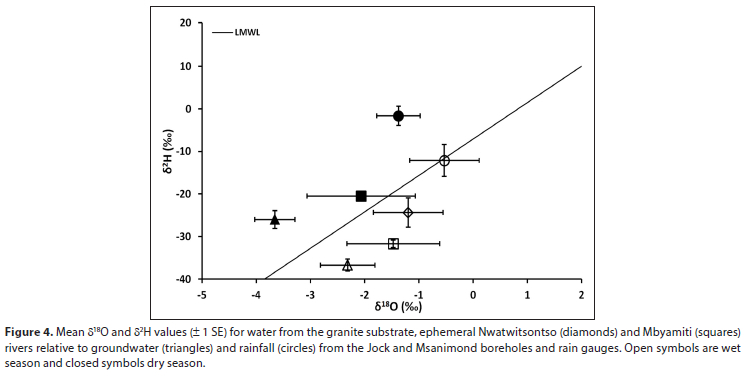
Mean values for surface water in the Mbyamiti River during the wet season when the river experienced high flows were δ180 = -1.26% ± 0.92%, n = 8 and δ2H = -28.61% ± 6.81%, and the groundwater (BH-Jock) values were δ180 = -2.11% ± 0.58%, n = 7 and δ2H = -29.81% ± 3.90% (Fig. 4). During the dry season, when the river experienced low flows, mean values for surface water were δ180 = -2.50% ± 0.05%, n = 8 and δ2H = -19.38% ± 5.81%, while the groundwater values were δ180 = -4.15% ± 0.02%, n = 4 and δ2H = -21.49% ± 1.44%. Along the ephemeral Nwaswitsontso River, a high-rainfall event during the wet season (January 2011) generated streamflow that lasted for about 1 month, then progressively receded to shallow pools, eventually drying up completely at the end of March 2011. Surface water isotope ratios during the flow period were δ18O = -1.55%o ± 1.61%, n = 5 and δ2H = -21.64% ± 0.86% and the groundwater (BH-Msanimond) values were δ18O = -2.48% ± 2.44%, n = 4 and δ2H= -40.13% ± 0.66% (Fig. 4). This river did not flow during the 2009-2011 drought.
DISCUSSION
The extensive similarity in δ2H and δ18O values between perennial rivers and groundwater indicate high interchange of water between these systems. Perennial rivers, such as the Sabie and Sand within the KNP, are always connected to the groundwater system. During the dry season when these rivers experience low flows and throughout the wet season during high-flow periods, groundwater is consistently discharged into these rivers. As a result, these two rivers act as catchment drains, intersecting the regional groundwater piezometric surface and maintaining baseflow conditions, as has been shown for perennial rivers in semi-arid ecosystems elsewhere (Xu et al., 2002; Lerner, 2003; Vegter and Pitman, 2003). The hydrological interaction and connectivity are critical in similar semi-arid systems where groundwater-dependent ecosystems are reliant on groundwater discharge during dry seasons (Colvin et al., 2003; Parsons, 2004).
The geology of the catchment associated with the Sweni and Mlondozi rivers is primarily composed of basalts and rhyolite, which have high clay content (Venter, 1986; Venter et al., 2003). The permeability of the surface and subsurface materials can greatly affect recharge and discharge processes; recharge is less likely to occur in areas that have finer-grained, less permeable sediments (Healy, 2010). Therefore, in areas of finer-grained sediments there would be decreased infiltration and enhanced surface runoff. These processes are observed on the Sweni and Mlondozi rivers as rainfall-runoff during the wet season generates streamflow; however, as rainfall decreases, streamflow subsides, resulting in standing pools of water along certain reaches of the river. Evaporation results in the water collected from these pools in the dry season having extremely enriched isotope ratios. These streams can be classified as detached or remote (Xu et al., 2002; Lerner, 2003; Vegter and Pitman, 2003), whereby the stream bed materials are impervious and the piezometric head is always below the stream bed material.
The stream bed material of the seasonal Mbyamiti and the ephemeral Nwaswitsontso rivers on the granite substrate is underlain by alluvial deposits, weathered porous granite material (coarse river sand) and rock. This combination of material promotes recharge, as the resulting soils have relatively high permeability and are capable of transmitting water rapidly (Healy, 2010). Typically, in seasonal rivers, the piezometric surface of the groundwater fluctuates alternately above and below the stream stage (Xu et al., 2002; Lerner, 2003; Vegter and Pitman, 2003). As a result, when the Mbyamiti River experiences peak flows during the wet season, groundwater is recharged from the river bed. Conversely, during the dry season, groundwater is discharged into the river, maintaining low flows and pools. Therefore, the Mbyamiti River is alternately an influent and effluent (intermittent) stream. The Nwaswitsontso River only flows after high-rainfall events. In typical ephemeral rivers, the groundwater piezometric surface is at all times below the stream bed level (Xu et al., 2002; Lerner, 2003; Vegter and Pitman, 2003).
As a result, during the wet season, after significant rainfall events, groundwater experiences indirect recharge through the river bed which acts as a preferential pathway (recharge sink).
This study has described the hydrogeological interactions between a range of river flow conditions and their geological setting, which should allow inferences to the region more broadly. Whilst it would be speculative to ascribe climate change impacts on these processes in the absence of a detailed modelling study, our observations do support recent opinion on the resilience of groundwater systems under climate change in dry subtropical regions of Africa (Cuthbert et al., 2019), where the positive feedback of the spatial-temporal intensification of precipitation anomalies could lead to increased recharge, particularly through ephemeral drainages, thus being made available for discharge to perennial surface water systems, despite possible drying trends overall.
Due to the complexities associated with quantifying and conceptualising sw-gw interactions (Sophocleous, 2002), particularly in semi-arid drainage regions where groundwater discharge into a river is not evenly distributed along its length but rather along discrete locations which include along fractures, faults and dykes, it is not uncommon to have different reaches gaining or losing water within a particular stream or river (Newman et al., 2006).
We, therefore, caution against the oversimplification of sw-gw interaction on a river or catchment scale. Nonetheless, the findings presented in this paper contributes to the understanding of sw-gw interaction to aid in further development and refining of sustainable groundwater resource management in the KNP.
CONCLUSION
In semi-arid African savanna, surface water and groundwater resources are intrinsically linked. Understanding these hydrologi-cal processes to manage the natural interaction, movement, and exchange between groundwater and rivers will be critical for the sustainable management of water resources within the KNP, as well as extrapolating this to the broader Lowveld catchments taking into account future climate change and accruing these benefits downstream of the protected area.
ACKNOWLEDGEMENTS
The authors would like to acknowledge the Mellon Foundation for the funding provided as part of the Junior Scientist Programme, SANParks, Ms Shamiela Davids for her support and expertise at the University of Cape Town isotope lab, the field assistance provided by Mr Renson Thethe and Mr Velly Ndlovu from SANParks, Ms Chenay Simms for producing the map and Dr Stefanie Freitag-Ronaldson, Dr Rina Grant and Dr Izak Smit for their guidance and mentorship during the project.
ORCID
Robin Petersen: https://orcid.org/0000-0002-2770-9461
REFERENCES
BRISTOW J and VENTER F (1986) Notes on the Permian to recent geology of the Kruger National Park. Koedoe 29 85-104. https://doi.org/10.4102/koedoe.v29i1.522 [ Links ]
COLEMAN ML, SHEPHERD TJ, DURHAM JJ, ROUSE JE and MOORE GR (1982) Reduction of water with zinc for hydrogen isotope analysis. Anal. Chem. 54 993-995. https://doi.org/10.1021/ac00243a035 [ Links ]
COLVIN C, LE MAITRE D and HUGHES S (2003) Assessing terrestrial groundwater dependent ecosystems in South Africa. WRC Report No. 1090-2/2/03. Water Research Commission, Pretoria. [ Links ]
CUTHBERT M, GLEESON T, MOOSDORF N, BEFUS KM, SCHNEIDER A, HARTMANN J and LEHNER B (2019) Global patterns and dynamics of climate-groundwater interactions. Nat. Clim. Change 9 137-141. https://doi.org/10.1038/s41558-018-0386-4 [ Links ]
DU PLESSIS A (2019) Evaluation of southern and South Africa's freshwater resources. In: Du Plessis A (ed.) Water as an Inescapable Risk. Current Global Water Availability, Quality and Risks with a Specific Focus on South Africa. 147-172. Springer Link. https://doi.org/10.1007/978-3-030-03186-2_7 [ Links ]
DU TOIT J, ROGERS K and BIGGS H (2003) The Kruger Experience: Ecology and Management of Savanna Heterogeneity. Island Press, Washington DC. [ Links ]
DU TOIT WH and VERSTER H (2017) Establishing a groundwater monitoring network in the Kruger National Park: Monitoring the fluctuation of groundwater levels under un-impacted conditions to determine short, medium and long term trends and to estimate TPC levels for abstraction boreholes. DWS Report No. GH 4264. Department of Water and Sanitation, Pretoria. [ Links ]
EASTERLING DR, MEEHL GA, PARMESAN C, CHANGNON SA, KARL TR and MEARNS LO (2000) Climate extremes: observations, modeling, and impacts. Science 289 2068-2074. https://doi.org/10.1126/science.289.5487.2068 [ Links ]
FISCHER S, WITTHÜSER K, BIRKE M, LEYLAND R and SCHNEIDER M (2009) Regional description of the groundwater chemistry of the Kruger National Park (KNP) using multivariate statistics. In: Groundwater Conference of the Geological Society of South Africa, 16-18 November 2009, Somerset West, South Africa. [ Links ]
FRICH P, ALEXANDER LV, DELLA-MARTA P, GLEASON B, HAYLOCK M, TANK AK and PETERSON T (2002) 0bserved coherent changes in climatic extremes during the second half of the twentieth century. Clim. Res. 19 193-212. https://doi.org/10.3354/cr019193 [ Links ]
GAT JR (1971) Comments on the stable isotope method in regional groundwater investigations. Water Resour. Res. 7 980-993. https://doi.org/10.1029/WR007i004p00980 [ Links ]
GERTENBACH WD (1980) Rainfall patterns in the Kruger National Park. Koedoe 23 35-43. https://doi.org/10.4102/koedoe.v23i1.634 [ Links ]
GIBS0N J, EDWARDS T, BIRKS S, ST AMOUR N, BUHAY W, MCEACHERN P, WOLFE B and PETERS D (2005) Progress in isotope tracer hydrology in Canada. Hydrol. Process. 19 303-327. https://doi.org/10.1002/hyp.5766 [ Links ]
GLAZER AN and LIKENS GE (2012) The water table: The shifting foundation of life on land. Ambio 41 657-669. https://doi.org/10.1007/s13280-012-0328-8 [ Links ]
GLEES0N T, NOVAKOWSKI K, COOK PG and KYSER TK (2009) Constraining groundwater discharge in a large watershed: Integrated isotopic, hydraulic, and thermal data from the Canadian shield. Water Resour. Res. 45.https://doi.org/10.1029/2008WR007622 [ Links ]
GLEESON T and RICHTER B (2018) How much groundwater can we pump and protect environmental flows through time? Presumptive standards for conjunctive management of aquifers and rivers. River Res. Appl. 34 83-92. https://doi.org/10.1002/rra.3185 [ Links ]
HEALY RW (2010) Estimating Groundwater Recharge. Cambridge University Press, Cambridge. https://doi.org/10.1017/CB09780511780745 [ Links ]
HUGHES DA, PARSONS R and CONRAD JE (2007) Quantification of the groundwater contribution to baseflow. WRC Report No. 1498/1/07. Water Research Commission, Pretoria. [ Links ]
JAKEMAN AJ, BARRETEAU O, HUNT RJ, RINAUDO J-D, ROSS A, ARSHAD M and HAMILTON S (2016) Integrated groundwater management: an overview of concepts and challenges. In: Jakeman AJ, Barreteau 0, Hunt RJ, Rinaudo J-D and Ross A (eds) Integrated Groundwater Management. 3-20. Springer Link. https://doi.org/10.1007/978-3-319-23576-9_1 [ Links ]
JOVANOVIC N, MU Q, BUGAN RDH and ZHAO M (2015) Dynamics of M0DIS evapotranspiration in South Africa. Water SA 41 (1) 79-90. https://doi.org/10.4314/wsa.v41i1.11 [ Links ]
KALBUS E, REINSTORF F and SCHIRMER M (2006) Measuring methods for groundwater? surface water interactions: a review. Hydrol. Earth Syst. Sci. Discuss. 10 873-887. https://doi.org/10.5194/hess-10-873-2006 [ Links ]
LE MAITRE DC and COLVIN CA (2008) Assessment of the contribution of groundwater discharges to rivers using monthly flow statistics and flow seasonality. Water SA 34 549-564. https://doi.org/10.4314/wsa.v34i5.180652 [ Links ]
LERNER D (2003) Surface water-groundwater interactions in the context of groundwater resources. In: Xu Y and Beekman HE (eds) Groundwater Recharge Estimation in Southern Africa. IHP Series No. 64. UNESC0, Paris. [ Links ]
LIU Y and YAMANAKA T (2012) Tracing groundwater recharge sources in a mountain-plain transitional area using stable isotopes and hydrochemistry. J. Hydrol. 464 116-126. https://doi.org/10.1016/j.jhydrol.2012.06.053 [ Links ]
MABUNDA D, PIENAAR DJ and VERHOEF J (2003) The Kruger National Park: a century of management and research. In: Du Toit J, Rogers K and Biggs H (2003) The Kruger Experience: Ecology and Management of Savanna Heterogeneity. Island Press, Washington DC. 3-21. [ Links ]
MACFADYEN S, ZAMBATIS N, VAN TEEFFELEN AJ and HUI C (2018) Long-term rainfall regression surfaces for the Kruger National Park, South Africa: a spatio-temporal review of patterns from 1981 to 2015. Int. J. Climatol. 38 2506-2519. https://doi.org/10.1002/joc.5394 [ Links ]
MUSSÁ F, ZHOU Y, MASKEY S, MASIH I and UHLENBROOK S (2015) Groundwater as an emergency source for drought mitigation in the Crocodile River catchment, South Africa. Hydrol. Earth Syst. Sci. 19 1093-1106. https://doi.org/10.5194/hess-19-1093-2015 [ Links ]
NEWMAN BD, VIV0NI ER and GROFFMAN AR (2006) Surface water-groundwater interactions in semiarid drainages of the American southwest. Hydrol. Process. 20 3371-3394. https://doi.org/10.1002/hyp.6336 [ Links ]
PARSONS R (2004) Surface water:groundwater interaction in a Southern African context. WRC Report No. TT 218/03. Water Research Commission, Pretoria. [ Links ]
POHL B, MACRON C and MONERIE P-A (2017) Fewer rainy days and more extreme rainfall by the end of the century in Southern Africa. Sci. Rep. 7 1-7. https://doi.org/10.1038/srep46466 [ Links ]
PRAAMSMA T, NOVAKOWSKI K, KYSER K and HALL K (2009) Using stable isotopes and hydraulic head data to investigate groundwater recharge and discharge in a fractured rock aquifer. J. Hydrol. 366 35-45. https://doi.org/10.1016/j.jhydrol.2008.12.011 [ Links ]
PRICE K (2011) Effects of watershed topography, soils, land use, and climate on baseflow hydrology in humid regions: A review. Progr. Phys. Geogr. 35 465-492. https://doi.org/10.1177/0309133311402714 [ Links ]
RIDDELL ES, NEL J, FUNDISI D, JUMBI F, VAN NIEKERK A and LORENTZ SA (2015). Ephemeral hydrological processes in savannas. WRC Report No. TT 619/14. Water Research Commission, Pretoria. [ Links ]
RIDDELL ES, KILIAN W, VERSFELD W and KOSOANA M (2016) Groundwater stable isotope profile of the Etosha National Park, Namibia. Koedoe 58 1-7. https://doi.org/10.4102/koedoe.v58i1.1329 [ Links ]
ROGERS KH and O'KEEFFE J (2003) River heterogeneity: ecosystem structure, function and management. In: Du Toit J, Rogers K and Biggs H (2003) The Kruger Experience: Ecology and Management of Savanna Heterogeneity. Island Press, Washington DC. 189-218. [ Links ]
ROZANSKI K, FROEHLICH K and MOOK WG (2001) Environmental Isotopes in the Hydrological Cycle. Principles and Applications. Surfacewater. IHP-V: Technical Documents in Hydrology, Vol. 3 (ed. WG Mook), No. 39, UNESCO, Paris. [ Links ]
SCHUTTE I (1986) The general geology of the Kruger National Park. Koedoe 29 (1) a517. https://doi.org/10.4102/koedoe.v29i1.517 [ Links ]
SOCKI RA, KARLSSON HR and GIBSON EK (1992) Extraction technique for the determination of oxygen-18 in water using preevacuated glass vials. Anal. Chem. 64 829-831. https://doi.org/10.1021/ac00031a026 [ Links ]
SOPHOCLEOUS M (2002) Interactions between groundwater and surface water: the state of the science. Hydrogeol. J. 10 52-67. https://doi.org/10.1007/s10040-001-0170-8 [ Links ]
SPINONI J, NAUMANN G, CARRAO H, BARBOSA P and VOGT J (2014) World drought frequency, duration, and severity for 19512010. Int. J. Climatol. 34 2792-2804. https://doi.org/10.1002/joc.3875 [ Links ]
THOMAS J and ROSE T (2003) Environmental isotopes in hydrogeology. Environ. Geol. 43 532-532. https://doi.org/10.1007/s00254-002-0677-x [ Links ]
VEGTER J (2003) Hydrogeology of Groundwater: Region 19: Lowveld. WRC report No. TT 208. Water Research Commission, Pretoria. [ Links ]
VEGTER J and PITMAN W (2003) Recharge and stream flow. In: Xu Y and Beekman HE (eds) Groundwater Recharge Estimation in Southern Africa. IHP Series No. 64. UNESCO, Paris. 109-123. [ Links ]
VENTER F (1986) Soil patterns associated with the major geological units of the Kruger National Park. Koedoe 29 125-138. https://doi.org/10.4102/koedoe.v29i1.525 [ Links ]
VENTER F (1990) A classification of land for management planning in the Kruger National Park. PhD thesis, University of South Africa, Pretoria. [ Links ]
VENTER F and BRISTOW J (1986) An account of the geomorphology and drainage of the Kruger National Park. Koedoe 29 117-124. https://doi.org/10.4102/koedoe.v29i1.524 [ Links ]
VENTER FJ, SCHOLES RJ and ECKHARDT HC (2003) The abiotic template and its associated vegetation pattern. In: Du Toit J, Rogers K and Biggs H (2003) The Kruger Experience: Ecology and Management of Savanna Heterogeneity. Island Press, Washington DC. 83-129. [ Links ]
WADA Y and HEINRICH L (2013) Assessment of transboundary aquifers of the world-vulnerability arising from human water use. Environ. Res. Lett. 8 024003. https://doi.org/10.1088/1748-9326/8/2/024003 [ Links ]
WADA Y, VAN BEEK LP, SPERNA WEILAND FC, CHAO BF, WU YH and BIERKENS MF (2012) Past and future contribution of global groundwater depletion to sea-level rise. Geophys. Res. Lett. 39. https://doi.org/10.1029/2012GL051230 [ Links ]
WADA Y, VAN BEEK LP, VAN KEMPEN CM, RECKMAN JW, VASAK S and BIERKENS MF (2010) Global depletion of groundwater resources. Geophys. Res. Lett. 37. https://doi.org/10.1029/2010GL044571 [ Links ]
WEAVER JM, CAVE L and TALMA AS (2007) Groundwater sampling. WRC Report No. TT 303. Water Research Commission, Pretoria. [ Links ]
XU Y, TITUS R, HOLNESS S, ZHANG J and VAN TONDER G (2002) A hydrogeomorphological approach to quantification of ground-water discharge to streams in South Africa. Water SA 28 375-380. https://doi.org/10.4314/wsa.v28i4.4910 [ Links ]
ZAMBATIS N (2003) Determinants of grass production and composition in the Kruger National Park. MSc thesis, University of Natal, Pietermaritzburg. [ Links ]
ZEKTSER I and LOAICIGA HA (1993) Groundwater fluxes in the global hydrologic cycle: past, present and future. J. Hydrol. 144 405-427. https://doi.org/10.1016/0022-1694(93)90182-9 [ Links ]
 Correspondence:
Robin Petersen
Scientific Services, South African National Parks, The Royal Hotel, Knysna, South Africa
Email: robin.petersen@sanparks.org
Received: 25 April 2022
Accepted:18 April 2023

