


Servicios Personalizados
Articulo
 Inglés (pdf)
 Articulo en XML
 Referencias del artículo
Indicadores

Links relacionados
-
 Citado por Google
 -
 Similares en Google
Compartir

 Permalink
Water SA
versión On-line ISSN 1816-7950
versión impresa ISSN 0378-4738
Water SA vol.44 no.4 Pretoria oct. 2018
http://dx.doi.org/10.4314/wsa.v44i4.16
SHORT COMMUNICATION
Isotopic tracing of stormwater in the urban Liesbeek River
Ruan van MazijkI; Lucy K SmythI, II; Eleanor A WeidemanI, III; Adam G WestI, *
IDepartment of Biological Sciences, University of Cape Town, Rondebosch, South Africa
IIInstitute for Communities and Wildlife in Africa (iCWild), University of Cape Town, Rondebosch, South Africa
IIIFitzPatrick Institute of African Ornithology, University of Cape Town, Rondebosch, South Africa
ABSTRACT
The ongoing drought in the Western Cape of South Africa (2014 to present) has called for an urgent need to improve our understanding of water resources in the area. Rivers within the Western Cape are known to surge rapidly after rainfall events. Such storm-flow in natural river catchments in the Jonkershoek mountains has previously been shown to be driven by displaced groundwater, with less than 5% of rainfall appearing in the storm-flow. However, the origin of storm-flow surges within urban rivers in the region remains unknown. In this study, we used stable isotopes in water to illustrate that at least 90% of water in the Liesbeek River during a storm event was rainwater. There was a strong correlation between storm-flow and rainfall rates (P < 0.001, Pearson's r = 0.86), as well as between the δ18O and δ2H values of river-water and rainwater (δ18O: Pearson's r = 0.741 (P = 0.001), δ2H: Pearson's r = 0.775 (P < 0.001)). Storm-flow within this urban river therefore appears to be driven by overland-flow over the hardened urban catchment, rather than piston-flow as seen in natural catchments. Our results support studies suggesting the Liesbeek River could be a target for stormwater harvesting to augment water resources in the city of Cape Town.
Keywords: stable isotopes, urban water management, water resources, urban rivers
INTRODUCTION
Water resources in the Western Cape of South Africa are scarce and are predicted to become increasingly so in the future (Otieno and Ochieng, 2004). At the time of this study the City of Cape Town was poised to become the first major city to run out of water (Du Toit, 2018). Currently, the cities within this predominately winter-rainfall region rely on surrounding dams for their water supply, which are generally replenished through winter streamflow. During drought years, streamflow recharge into dams is severely diminished (Mukheibir and Ziervogel, 2007). Extended below-average rainfall in the region since 2014 led to severe water shortages in the City of Cape Town and in 2017 threatened the potential collapse of the city's water infrastructure (so-called 'DayZero'). In order to secure future water supply, cities in the Western Cape will have to adapt to the likelihood of reduced rainfall in the future (New, 2002; Ziervogel et al., 2011), as well as augment their water supply from alternative sources such as aquifers and stormwater amongst others (New, 2002; Fisher-Jeffes et al., 2017). As such, understanding the storm-flow dynamics of rivers in this region and their relationship to rainfall is important, to properly manage the area's water resources.
Rivers in the Western Cape are known to rapidly increase in flow following rainfall. Midgley and Scott (1994) showed that streamflow in rivers in the Jonkershoek mountains surged within a few hours of the first rains. Using stable isotopes, they demonstrated that despite flow increasing by 400%, the storm-flow consisted of less than 5% of the rainfall event, leading to the conclusion that these rivers were fuelled mainly by piston-flow. Piston-flow occurs when rainwater seeps into the ground, displacing groundwater which then flows into the river (Sophocleous, 2002). Piston-flow is an important process for aquifer recharge, but may result in delayed storm-flow after extensive aquifer drawdown (McGuire et al., 2002). However, while piston-flow may generally be the predominant pathway for storm-flow in natural, fractured sandstone catchments (Midgley and Scott, 1994; Midgley et al., 2001), little is known about the dynamics of storm-flow from other rivers in this region, particularly urban areas where substrate permeability is low. In such areas, overland-flow should predominate, resulting in rainwater directly recharging streams without sinking into the ground to recharge aquifers (Burns et al., 2001). Unlike for piston-flow, overland-flow should result in rapid storm-flow surges even in the case where aquifers have been drawn down substantially during prolonged drought.
Additionally, unless overland-flow-driven streams are captured in dams or water storage schemes, usually not the case for low-elevation urban rivers, this water will eventually be lost to the sea without the benefit of aquifer recharge (Frazer, 2005; Saraswat et al., 2016). In June 2017, during a prolonged 3-year drought, a large storm hit Cape Town resulting in severe winds and precipitation across the city. We used this opportunity to determine whether overland or piston-flow predominated in the urban Liesbeek River and to assess the stormwater discharge occurring during a drought. The source of the increase in storm-flow was determined using stable isotopes of hydrogen (δ2H (‰)) and oxygen (δ18O (‰)) of river-water and rainfall (McGuire and McDonnel, 2007). We reasoned that a predominance of overland-flow would result in rainfall and storm-flow closely tracking each other throughout the storm event. However, if rainfall and storm-flow were isotopically dissimilar, or showed strong lags, then piston-flow was more likely to predominate.
We hypothesized that despite the mountain headwaters, this section of river flowing through the urban environment would be driven primarily by overland-flow, due to the extensive hardening of its urban catchment. If so, this would have implications for the effective future use of stormwater in this river to augment the City of Cape Town's scarce water resources.
METHODS
Study area
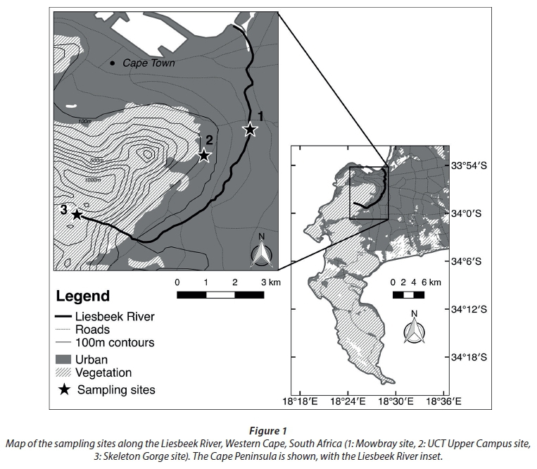
The Liesbeek River originates in the natural Table Mountain sandstone catchment above Kirstenbosch but then flows through the southern suburbs of Cape Town (Fig. 1), where approximately 40% of its channel has been canalised (River Health Programme, 2005; Brown and Magoda, 2009). It has a total catchment area of 327 km2 and flows most strongly during the wet winter months. Flow is reduced during summer months, with the shallow upper and middle reaches often drying completely (Suri et al., 2017).
Sampling methods
Prior to the storm, rain gauges were placed at the river sampling point in Mowbray (33° 56′ 48.23″ S 18° 28′ 39.69″ E, 11 m amsl), at the University of Cape Town's Upper Campus (UCT, 33° 57′ 24.30″ S 18° 27′ 40.00″ E, 120 m amsl) and at the top of Skeleton Gorge on Table Mountain (the Liesbeek's headwaters, 33° 58′ 42.38″ S 18° 24′ 48.42″ E, 820 m amsl). Periodic measurement of accumulated rainfall amount and isotopic composition were recorded at the Mowbray gauge throughout the storm event. After recording rainfall amount, rainwater samples were decanted into 10 mL centrifuge vials, sealed with Parafilm (Bemis Flexible Packaging, Neenah, WI 54956, USA) and transported to the laboratory for analysis. The rain gauge was emptied and reset until the next collection.
For practical purposes, the UCT and Skeleton Gorge rain gauges were only assessed after the storm had passed. As such, these only reflect total rainfall and isotopic composition at those stations. No attempt was made to limit evaporative losses from the rain gauges during collection as these gauges were only exposed to the atmosphere during the storm, when evaporative losses would be minimal, and were sampled immediately thereafter. All isotope analyses were conducted within 24 hours of sample collection.
River-water was sampled from a weir in a canalised section of the Liesbeek River in Mowbray (33° 56° 48.23 S 18° 28° 39.69 E, 4 m amsl). Samples were taken prior to the storm event, at multiple intervals throughout the storm (in conjunction with Mowbray rainfall) and for 8 h after the storm had passed. River-water samples were collected from below the water's surface in a fast-flowing section mid-stream. Simultaneously, streamflow measurements were obtained by measuring the time (Δt) it took a nearly submerged floating object to travel a fixed distance (Δx) down the middle of the channel. We used small oranges as floating objects as they were visible at night and approximately the density of water and thus mostly submerged and unaffected by wind. The depth of the water in the canalized channel (d) and breadth of the channel (b) was also measured. From these measurements, streamflow rate (ν) (m3·h-1) was calculated as:

As we did not measure ∆x/∆t across the entire breadth of the canal, notably near the edges where flow may be slower than midstream, our estimate of streamflow represents an upper limit of potential streamflow and most likely overestimates true streamflow.
Total storm-flow (T, m3) was approximated as the sum of streamflow over the duration of the storm, assuming constant flow between measurements, from the beginning of the storm until the flow returned to base levels after the storm
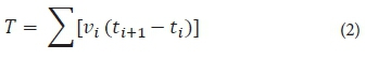
where vi is the streamflow (m3·hr-1) at time i and ti+1 - ti (h) is the interval between time i and the following measurement at time i+1.
Stable isotope analyses
Isotopic composition (δ 2H and δ 18O) of water samples was analysed by wavelength-scanned cavity ring-down spectroscopy (WS-CRDS, Gupta et al., 2009) using a L2120-i (Picarro Inc., 480 Oakmean Parkway, Sunnyvale, California, 94085, USA; www.picarro.com) in the Department of Biological Sciences, UCT. Liquid water samples were filtered through a 20 μm filter into 2mL sample vials and analysed within 24 h of collection. Isotope ratios are expressed in ‰ as:
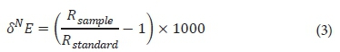
where N is the atomic mass of the heavy isotope of element E and Rsample/Rstandard is the ratio of the heavy to light isotope (2H/H or 18O/16O). Samples were corrected to Vienna Standard Mean Ocean Water (VSMOW) using a linear correction function based on two laboratory standards that spanned the range of values in our samples. Accuracy was determined using a quality control standard that was not used in standard corrections. Long-term precision and accuracy of this instrument were 0.2‰ and 1.5‰ for δ2H and 0.07‰ and 0.13‰ for δ18O, respectively. We propagated these uncertainties appropriately (Genereux, 1998), conservatively treating total analytical uncertainty for isotope values as the combination of precision and accuracy. Due to the potential for organic contaminants to interfere with WS-CRDS measurements (West et al., 2010; Brand et al., 2009), all analyses were run through post-processing software (ChemCorrect version 1.2) to detect for possible organic contamination (West et al., 2011). No indications of contamination were seen for any of our river and rain samples.
Statistical analyses
All analyses were carried out in R (R Core Team, 2017) using the 'tidyverse' suite of packages (Wickham, 2017) for data exploration and visualisation. Simple linear regressions were performed for: streamflow rate against rainfall rate, δ18O and δ2H of stream-water against those of rainwater and δ18O against δ2H for stream-water and rainwater. Additionally, we assessed whether the residuals in these linear models depended on a measurement's timing within the sampling period, using regressions of those residual values against time, to ascertain whether the strength of coupling between stream- and rainwater isotope values changed during the course of the storm. We also constructed a local meteoric water line (LMWL) for Cape Town using previously published data (Harris et al., 2010) as the linear regression of rainwater δ18O against δ2H for Cape Town, across 4 years, from 2013 to 2016.
We calculated the proportion of storm-flow that was rainfall-derived using a mass-balance model, following the approach of Midgley and Scott (1994) and Midgley et al. (2001). We assumed only two inputs into the stream over the course of the storm: baseflow and rainfall. We used the isotope values of the stream before the storm as our estimate of baseflow (δbaseflow), the amount-weighted isotope values of the storm's cumulative rainfall (δrain) and the amount-weighted isotope values of the total river storm-flow (δstormflow) to calculate p, the proportion of storm-flow that was derived from rainfall (Eq. 4). This was done for each isotopic tracer separately, and then averaged, with propagated uncertainties.
RESULTS
A total of 53 mm of rainfall fell during the 52 h of the study period at the Mowbray study site (Fig. 2A). The flow rate of the Liesbeek River increased 100-fold during the storm, from 61 m3·h-1 (0.017 m3·s-1) before the storm, to a peak of 6 661 m3·h-1 (1.850 m3·s-1) during the storm, before dropping back to 68 m3·h-1 (0.019 m3·s-1) approximately 10 h after the last rain fell. Approximately 41 375.8 m3 flowed down the river during the storm event (total storm-flow, T). There was a strong correlation between streamflow and rainfall rates (P < 0.001, Pearson's r = 0.86, Figs 2B, 2C, 3A).
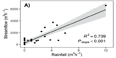

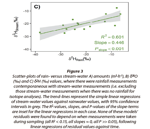
There was also a strong correlation between the isotopic composition of the rainwater and stormwater (Pearson's r = 0.741 and 0.775 for δ18O and δ2H, respectively, P < 0.001 in both cases) (Figs 2D, 2E). The δ18O and δ2H values of rainwater were more variable than those of the stream-water (Fig. 2D, 2E). δ18O ranged from -2.02‰ to -6.06‰ in stream-water and -2.95‰ to -7.75‰ in rainwater and δ2H ranged from -5.34‰ to -28.37‰ in stream-water and -8.60‰ to -40.06‰ in rainwater. We found no significant relationship between stream- versus rainwater residuals (Fig. 3) and time, suggesting that the strength of the relationship between stream- and rainwater isotope values (Fig. 3B, 3C) (and indeed streamflow and rainfall amounts (Fig. 3A)) was relatively uniform during the course of the storm event.
The isotopic composition of the rain and stream measured during this storm was indistinguishable from the LMWL for the Cape Town area (derived from long-term data from Harris et al. (2010)), suggesting that rainfall is the principal source of water to streamflow within the section of river studied (Fig. 4). Notably, the amount-weighted isotope values for the Mowbray and UCT rainfall (δ18O = -4.79‰, δ2H = -20.09‰ and δ18O = -5.08‰, δ2H = -20.50‰, respectively, Fig. 4) were similar, and both markedly isotopically heavier in both δ2H and δ18O than that from Skeleton Gorge (δ18O = -5.99‰, δ2H = -22.48‰, Fig. 4).
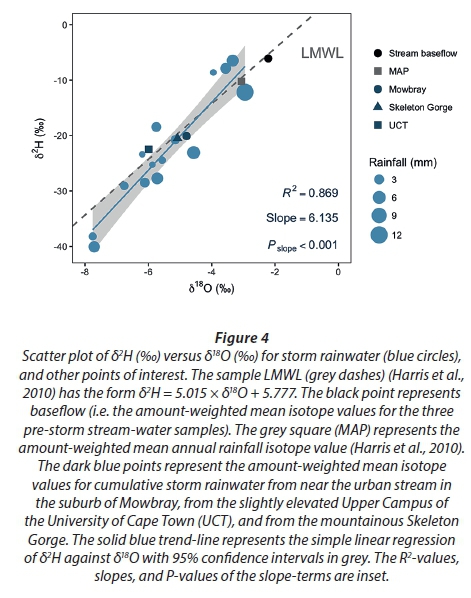
Following the mass-balance model (Eq. 4), we calculated the contribution of rainfall to the storm-flow in the Liesbeek River. Using the amount-weighted values for streamflow, rainfall and storm-flow (Table 1), we calculated that 101.1% (± 10.7%) of storm-flow was derived from rainfall. This suggests that stream-water was almost entirely (> 90%) derived from recent rainwater.

DISCUSSION
Here we have presented the isotopic similarity of river and rainwater throughout the storm event, a strong correlation between streamflow and rainfall rates and a large proportion (> 90%) of rainwater making up the streamflow during the storm event. We therefore conclude that overland-flow is the predominant driver of the river's flow rate during this rainfall event. The isotopic similarity between stream- and rainwater, and the degree to which these values track each other during the storm event, suggest that recent rainfall is indeed the majority contributor to storm-flow. This directly contrasts with the finding of piston-flow in the natural catchments of the nearby Cape rivers in the Jonkershoek Valley and on Table Mountain (Midgley and Scott, 1994; Midgley et al., 2001) and is most likely due to the hardening of the urban catchment around the Liesbeek River decreasing the infiltration capacity of the substrate and resulting in high overland-flow.
While factors such as soil type and rock cover cause a natural variation in the porosity of the land surface (Graniel et al., 1999), changes in surface porosity in urban areas have serious effects on the hydrological cycle (Sharp, 2010). Groundwater recharge rates are affected by impervious cover, which causes them to become less dependent on rainfall and more dependent on artificial forms of recharge, such as leakages and irrigation (Sharp, 2010). Increases in impervious cover and overland-flow can cause rainwater to run directly into rivers and out to sea, without recharging soil reservoirs or aquifers, thereby increasing an area's susceptibility to water shortages (Bruijnzeel, 2004).
A key implication of our study is that a potentially valuable source of water for the over-extended City of Cape Town's water supply is being lost directly to the sea, without influencing aquifer recharge. Considering the dire water crisis that the City currently finds itself in, any additional water sources that could augment its supply merit investigation.
When performed correctly, stormwater harvesting has been identified as beneficial for ecological, environmental and social reasons (Fletcher et al., 2007; Mitchell et al., 2007; Inamdar et al., 2013). While the City of Cape Town has already begun emergency development of aquifer extraction for municipal water use (Evans, 2018), recharge of these aquifers must be considered. Our study supports previous work suggesting that artificial recharge, as well as domestic water use, could include stormwater harvested from the Liesbeek River (Inamdar et al., 2013; Fisher-Jeffers et al., 2017).
ACKNOWLEDGEMENTS
We acknowledge the contributions of R de Wet, K Atkins, V Coetzee, M Cruickshank, D Hegarty and L Van Der Pas during data collection and processing. Prof JJ Midgley contributed to the experimental design.
SUPPORTING INFORMATION
Data-sets and analyses in the form of R-scripts are available online at https://github.com/rvanmazijk/Liesbeek-River-isotopics.
ORCID
Ruan van Mazijk: https://orcid.org/0000-0003-2659-6909
Lucy K Smyth: https://orcid.org/0000-0002-6177-3133
Eleanor A Weideman: https://orcid.org/0000-0001-5084-0532
Adam G West: https://orcid.org/0000-0002-9352-9282
REFERENCES
BRAND WA, GEILMAN H, CROSSON ER and RELLA CW (2009) Cavity ring-down spectroscopy versus high-temperature conversion isotope ratio mass spectrometry; a case study on δ2H and δ18O of pure water samples and alcohol/water mixtures. Rapid Commun. Mass Spectrosc. 23 (12) 1879-1884. https://doi.org/10.1002/rcm.4083 [ Links ]
BROWN C and MAGOBA R (2009) Rivers and wetlands of Cape Town: caring for our rich aquatic heritage. WRC Report No. TT 376/08. Water Research Commission, Pretoria. ISBN 978-1-77005-777-7. [ Links ]
BRUIJNZEEL LA (2004) Hydrological functions of tropical forests: not seeing the soil for the trees? Agric. Ecosyst. Environ. 104 185-228. https://doi.org/10.1016/j.agee.2004.01.015. [ Links ]
BURNS DA, MCDONNELL JJ, HOOPER RP, PETERS NE, FREER JE, KENDALL C and BEVEN K (2001) Quantifying contributions to storm runoff through end-member mixing analysis and hydrologic measurements at the Panola Mountain Research Watershed (Georgia, USA). Hydrol. Process. 15 1903-1924. https://doi.org/10.1002/hyp.246 [ Links ]
DU TOIT C (2018) Countdown Clock: Day Zero looms for Cape Town. eNCA. 27 January 2018. URL: https://www.enca.com/south-africa/countdown-clock-day-zero-looms-for-cape-town (Accessed 1 July 2018). [ Links ]
EVANS J (2018) Drilling on Cape Flats Aquifer starts as Cape Town dams dry up in drought. News24. 11 January 2018. URL: https://www.news24.com/SouthAfrica/News/drilling-on-cape-flats-aquifer-starts-as-cape-town-dams-dry-up-in-drought-20180111 (Accessed 1 July 2018). [ Links ]
FISHER-JEFFES L, CARDEN K, ARMITAGE NP and WINTER K (2017) Stormwater harvesting: Improving water security in South Africa's urban areas. S. Afr. J. Sci. 113 (1/2), Art. #2016-0153, 4 pp. https://doi.org/10.17159/sajs.2017/20160153 [ Links ]
FLETCHER TD, MITCHELL VD, DELETIC A, LADSON TR and SEVEN A (2007) Is stormwater harvesting beneficial to urban waterway environmental flows? Water Sci. Technol. 55 (4) 265-272. https://doi.org/10.2166/wst.2007.117 [ Links ]
FRAZER L (2005) Paving Paradise: The peril of impervious surfaces. Environ. Health Perspect. 113 (7) A456-A42. https://doi.org/10.1289/ehp.113-a456. [ Links ]
GENEREUX D (1998) Quantifying uncertainty in tracer-based hydrograph separations. Water Resour. Res. 34 (4) 915-919. https://doi.org/10.1029/98WR00010 [ Links ]
GRANIEL CE, MORRIS LB and CARRILLO-RIVERA JJ (1999) Effects of urbanisation on groundwater resources of Merida, Yucatan, Mexico. Environ. Geol. 37 (4) 303-312. https://doi.org/10.1007/s002540050388 [ Links ]
GUPTA P, NOONE D, GALEWSKY J, SWEENEY C and VAUGHN BH (2009) Demonstration of high-precision continuous measurements of water vapour isotopologues in laboratory and remote field deployments using wavelength-scanned cavity ring-down spectroscopy (WS-CRDS) technology. Rapid Commun. Mass Spectrom. 23 (16) 2534-2542. https://doi.org/10.1002/rcm.4100 [ Links ]
HARRIS C, BURGERS C, MILLER J and RAWOOT F (2010) O- and H- isotope record of Cape Town rainfall from 1996 to 2008, and its application to recharge studies of Table Mountain groundwater, South Africa. S. Afr. J. Geol. 113.1 33-56. https://doi.org/10.2113/gssajg.113.1.33 [ Links ]
INAMDAR PM, COOK S, SHARMA AK, CORBY N, O'CONNOR J and PERERA BJC (2013) A GIS based screening tool for locating and ranking of suitable stormwater harvesting sites in urban areas. J. Environ. Manage. 128 363-370. https://doi.org/10.1016/j.jenvman.2013.05.023 [ Links ]
MCGUIRE KJ, DEWALLE DR and GBUREK WJ (2002) Evaluation of mean residence time in subsurface waters using oxygen-18 fluctuations during drought conditions in the mid-Appalachians. J. Hydrol. 261 (1) 132-149. https://doi.org/10.1016/S0022-1694(02)00006-9 [ Links ]
MCGUIRE K and MCDONNELL J (2007) Stable isotope tracers in watershed hydrology. In: Michener R and Lajtha K (eds.) Stable Isotopes Ecol. Environ. Sci. (2nd edn). Blackwell Publishing, Oxford, UK. https://doi.org/10.1002/9780470691854.ch11 [ Links ]
MIDGLEY JJ and SCOTT DF (1994) The use of stable isotopes of water (D and 18O) in hydrological studies in the Jonkershoek Valley. Water SA 20 (2) 151-154. [ Links ]
MIDGLEY JJ, SCOTT DF and HARRIS C (2001) How do we know how much groundwater is stored in southwestern Cape mountains? S. Afr. J. Sci. 97 285-286. [ Links ]
MITCHELL VG, DELETIC A, FLETCHER TD, HATT BE and MCCARTHY DT (2007) Achieving multiple benefits from stormwater harvesting. Water Sci. Technol. 55 (4) 135-144. https://doi.org/10.2166/wst.2007.103 [ Links ]
MUKHEIBIR P and ZIERVOGEL G (2007) Developing a municipal adaptation plan (MAP) for climate change: the city of Cape Town. Environ. Urbanisation 19 (1) 143-158. https://doi.org/10.1177/0956247807076912 [ Links ]
NEW M (2002) Climate change and water resources in the southwestern Cape, South Africa. S. Afr. J. Sci. 98 369-376. ISSN: 0038-2353. [ Links ]
OTIENO FA and OCHIENG GMM (2004) Water management tools as a means of averting a possible water scarcity in South Africa by the year 2025. Water SA 30 (5) 120-124. [ Links ]
R CORE TEAM (2017) R: A language and environment for statistical computing. R Foundation for Statistical Computing, Vienna, Austria. URL: https://www.R-project.org/ [ Links ]
RIVER HEALTH PROGRAMME (2005) State of rivers report: greater Cape Town's rivers. Department of Water Affairs and Forestry, Pretoria. ISBN: 0-620-34026-6. [ Links ]
SARASWAT C, KUMAR P and MISHRA BK (2016) Assessment of stormwater runoff management practices and governance under climate change and urbanization: An analysis of Bangkok, Hanoi and Tokyo. Environ. Sci. Polic. 64 101-117. https://doi.org/10.1016/j.envsci.2016.06.018 [ Links ]
SHARP JM (2010) The impacts of urbanization on groundwater systems and recharge. AQUAmundi Am. 1008 51-56. DOI: 10.4409/Am-004-10-0008. [ Links ]
SOPHOCLEOUS M (2002) Interactions between groundwater and surface water: the state of the science. Hydrogeol. J. 10 52-67. https://doi.org/10.1007/s10040-001-0170-8 [ Links ]
SURI J, ANDERSON PM, CHARLES-DOMINIQUE T, HELLARD E and CUMMING GS (2017) More than just a corridor: A suburban river catchment enhances bird functional diversity. Landscape Urban Plann. 157 331-342. https://doi.org/10.1016/j.landurbplan.2016.07.013 [ Links ]
WEST AG, GOLDSMITH GR, BROOKS PD and DAWSON TE (2010) Discrepancies between isotope ratio infrared spectroscopy and isotope ratio mass spectrometry for the stable isotope analysis of plant and soil waters. Rapid Commun. Mass Spectrom. 24 1948-1954. https://doi.org/10.1002/rcm.4597 [ Links ]
WEST AG, GOLDSMITH GR, MATIMATI I and DAWSON TE (2011) Spectral analysis software improves confidence in plant and soil water stable isotope analyses performed by isotope ratio infrared spectroscopy (IRIS). Rapid Commun. Mass Spectrom. 25 2268-2274. DOI: 10.1002/rcm.5126. https://doi.org/10.1002/rcm.5126 [ Links ]
WICKHAM H (2017) Tidyverse: Easily install and load tidyverse packages. R package version 1.1.4. URL: https://CRAN.R-project.org/package=tidyverse (Accessed 2 July 2018). [ Links ]
ZIERVOGEL G, SHALE M and DU M (2011) Climate change adaptation in a developing countrycontext: the case of urban water supply in Cape Town. Clim. Dev. 2 (2) 94-110. https://doi.org/10.3763/cdev.2010.0036 [ Links ]
Received 14 February 2018
Accepted in revised form 25 September 2018.
* To whom all correspondence should be addressed. +27 21 650 3628; e-mail: adam.west@uct.ac.za

