


Servicios Personalizados
Articulo
 Inglés (pdf)
 Articulo en XML
 Referencias del artículo
Indicadores

Links relacionados
-
 Citado por Google
 -
 Similares en Google
Compartir

 Permalink
Water SA
versión On-line ISSN 1816-7950
versión impresa ISSN 0378-4738
Water SA vol.44 no.4 Pretoria oct. 2018
http://dx.doi.org/10.4314/wsa.v44i4.20
ORIGINAL ARTICLES
Impact of invasive alien plants on water provision in selected catchments
IR PrestonI, II; DC Le MaitreIII, IV; JN BlignautV, VI; L LouwII; CG PalmerI
IInstitute for Water Research, Rhodes University, South Africa
IIDepartment of Management, Rhodes University, South Africa
IIICSIR Natural Resources and the Environment, Stellenbosch, South Africa
IVCentre for Invasion Biology, Department of Botany and Zoology, Stellenbosch University, South Africa
VSouth African Environmental Observation Network (SAEON), Pretoria, South Africa
VISchool of Public Leadership, Stellenbosch University, South Africa
ABSTRACT
We analyse the impact of failing to control invasive alien plants (IAPs) on the water supply to the Berg River and De Hoop Dams, in other words, the opportunity cost of not clearing IAPs in these two catchments. To do this we used models to assess and compare the impact of current and future invasions on inflows into the dams. Although the clearing of current invasions would only provide a modest increase in the amount of water compared to, for example, the construction of another dam, failure to clear the invasion will have a negative impact on water security in the long term. We estimated that the Berg River Dam could lose up to 51% of its mean annual inflows to IAPs over a 45-year period, and the De Hoop Dam catchment could lose up to 44%. These impacts would continue to increase over time, and the costs of control could become very high as the plants invade rugged terrain. Major infrastructural development requires Ministerial approval, supported by advice from senior officials. We suggest that such advice should substantively take sufficient account of the benefits of clearing existing invasions, or at least of preventing further invasions. Our results suggest that serious consequences arise from insufficient investment in catchment management. An integrated approach to the management of the supply of and demand for water, that ensures long-term sustainability, is essential in informed decision-making and the early control of IAPs is a key component of that approach.
Keywords: invasive alien species, water supply, catchment management, long-term water security, investment in restoration of natural capital, economic impact of control
INTRODUCTION
Invasive alien plants (IAPs) are plants that have been introduced into an area in which they did not previously occur. In many instances they have been able to outcompete and displace indigenous plants because of the lack of pests, specialist herbivores and pathogens (IUCN, 2000). Some of these IAPs alter the quantity, quality and timing of water flows by using more water than the plants they displace (Le Maitre et al., 2015; Cullis et al., 2007). It therefore goes without saying that the impact of IAPs on water availability, especially in arid countries such as South Africa, is an important consideration for the management of catchments for water security, and more so in those with water supply infrastructure. Minimising the impacts of IAPs by effective management can contribute to sustaining low flows in rivers, dam yields and protects the longevity of the water infrastructure (Le Maitre and Görgens, ٢٠٠٣; Le Maitre et al., 2002; Van Wilgen et al., 1997). If no control is done, the costs of not clearing IAPs can become extremely high and can escalate at an exponential rate (Marais and Wannenburgh, 2008; Le Maitre et al., 2002). Additionally, riparian invasions typically use much more water than non-riparian invasions (of the same species) because they maintain higher rates of evapo-transpiration, as does Black Wattle (Acacia mearnsii) (Le Maitre et al., 2015; Everson et al., 2014; Van Wilgen and Richardson, 2014; Dzikiti et al., 2013a; Dye and Jarmain, 2004).
The effect of IAPs on evapo-transpiration and runoff has been the subject of much research, originally being based on studies of the hydrological impacts of plantations on pines and eucalypts (Görgens and Van Wilgen, 2004; Le Maitre et al., 1996; Le Maitre et al., 2002) but subsequently extended to wattles (in a plantation), poplars and Prosopis species (see Le Maitre et al., 2015; Dzikiti et al., 2016; Dzikiti et al., 2013a; Dzikiti et al., 2013b; Milton and Dean, 2010; Le Maitre et al., 2009; Everson, et al., 2007). The original flow reduction models were based on volume reductions (e.g. Le Maitre et al., 2002) but have been replaced with more hydrologically sound proportional flow reduction models, based on those developed from plantation studies (Scott and Smith, 1997), and adapted for riparian settings (Dzvukamanja et al., 2005; Le Maitre et al., 2016; Le Maitre et al., 2013). The findings of this research are consistent with those of studies worldwide which show that changes in vegetation characteristics result in changes in evaporation and consequently in river flows, especially the introduction of tall, woody, plant species like trees, whether or not those species are indigenous (Le Maitre et al., 2015; Doody et al., 2011; Zhang et al., 2001).
Although these studies provide strong evidence that many IAP species reduce runoff, modelling these effects is a more complicated matter. Variation in IAP species, species-specific effects on runoff, rates of spread and of densification, vulnerability to wild fires, and terrain (such as aspect, slope, availability of water, and soil type) all increase the complexity of the modelling. Despite this, the current national estimates of the effects of IAPs on runoff and yield are that IAPs are currently using approximately 3% of mean annual runoff (MAR) and possibly as much as 5% (Le Maitre et al., 2016; Le Maitre et al., 2013). Furthermore, the South African Department of Water and Sanitation estimated that IAPs reduced dam yields by 695 million m3/yr in 2013 (DWA, 2013). The impact of IAPs is particularly severe in the dry season, mainly because the deep root systems of IAPs are able to access deep water sources (Le Maitre, 2004) resulting in a greater reduction of baseflows than MAR (Scott and Smith, 1997; Scott and Lesch, 1997), especially for riparian invasions (Everson et al., 2014). The low flows are particularly important for water security, especially in the context of users dependent on run-of-river utilisation and droughts (Van Wilgen and Richardson, 2014; Dye and Jarmain, 2004; Görgens and Van Wilgen, 2004).
Given the potential magnitude and severity of the impacts of IAPs, this paper analyses the costs and benefits related to IAP management as a component of water conservation and the enhancement of existing supplies of water. We focus on the catchments of two dams built after the National Water Act (RSA, 1998) came into force, namely, the catchments of the Berg River Dam in the Western Cape and the De Hoop Dam in Limpopo Province. We assess whether IAP management can enhance long-term water security through widening the combination of demand and supply options and, conversely, assess what is the opportunity cost of not controlling IAPs in the case of these two dam catchments. We do so by modelling the impact of IAPs in the study sites as if no IAP management has occurred over a 45-year period (this being the average planned lifespan of dams built in South Africa).
Study sites
Two study sites were selected that represent differences in geographic location, climate, catchment size, as well as types and levels of IAPs present, and where dams had been built in the past 25 years (to ensure data availability). These were the Berg River Dam catchment and the De Hoop Dam catchment.
Berg River Dam catchment
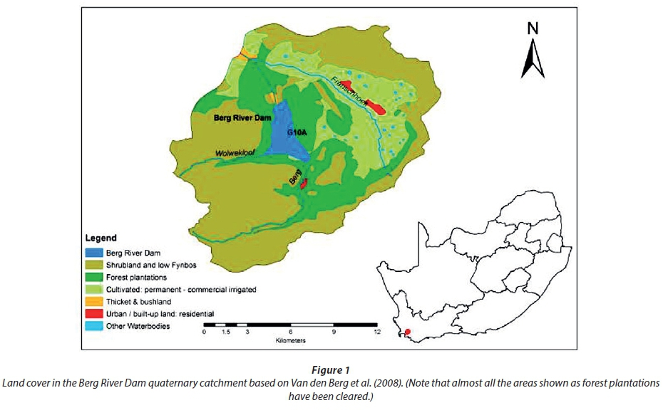
The Berg River Dam is found on the Berg River near Franschhoek, in the Western Cape (Fig. 1), and is part of a scheme that provides water to Cape Town. It is situated in the middle of a single quaternary catchment, G10A, which covers about 17 185 ha. G10A is mountainous and largely covered by a mix of low fynbos and shrubland, as well as cultivated land and Pinus spp. plantations. The mean annual rainfall in the catchment is about 1 610 mm/yr (Middleton and Bailey, 2008) and a large proportion of the catchment consists of high mountains that receive in excess of 2 000-2 500 mm/yr (Schulze et al., 2008). Although the dam is not situated at the outflow from the catchment, the design includes a weir downstream, from which water can be pumped back to the dam (Matthews, 2006), so that the impacts of invasions below the dam will also affect yields. The portion of G10A that was covered by Pinus plantations has been cleared as a condition of building the Berg River Dam. About 13 570 ha have natural or semi-natural land cover based on the National Land Cover 2000 (Van den Berg et al., 2008) and are considered to be invadable (Kotzé et al., 2010).
De Hoop Dam catchment
The De Hoop Dam is located on the Steelpoort River in Limpopo Province (Fig. 2). The De Hoop Dam catchment is made up of 6 quaternary catchments, B41A to B41F. The total size of the catchment is 286 489 ha. About 233 875 ha are still natural vegetation, which is considered to be invadable (Kotzé et al., 2010). The mean annual precipitation is about 688 mm and the mean annual runoff is about 47 mm (Bailey and Middleton 2008).
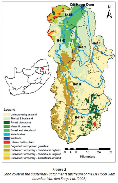
The De Hoop Dam catchment has a variety of land-cover types (Van den Berg et al., 2008), the most extensive of which is natural grassland. Upstream of the dam (B41C, B41E and the lower half of B41F), the natural vegetation is largely thicket, bushland, forests and woodland - all of which can be invaded by alien species already in the catchments. Further upstream from the dam (B41A, B41B and the upper half of B41F), the land cover is largely made up of natural grassland (invadable) and cultivated land (assumed to be permanently transformed and therefore not invadable). Quaternary catchments B41A, B41D and B41E contain some urban land cover (not invadable), while B41A also contains a majority of the forest plantations in the catchment, which are largely of Eucalyptus and Pinus species and also not considered invadable (Kotzé et al., 2010).
Current invasion levels in study sites
The Working for Water Programme (WfW) has cleared large areas of IAPs in the Berg River Dam catchment (G10A) over several years, spending 90.2 million ZAR by the end of 2013 (in 2017 Rand/ZAR values) and clearing about ٣ ٦٠٧ condensed ha (the equivalent hectares when the canopy cover is mathematically adjusted to 100%). The calculation of a condensed hectare (CH) is shown in Eq. 1.
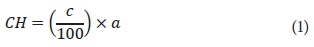
where: a is the area and c is the percentage of cover in the area.
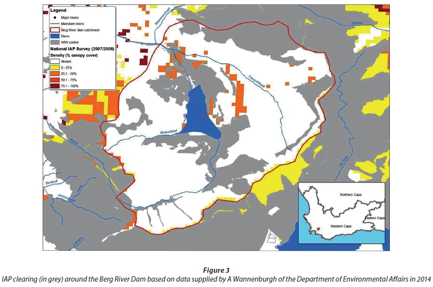
It is estimated that about 1 175 ha (9% of the invadable area) in the Berg River Dam catchment are invaded by IAPs, predominantly Pinus species (Fig. 3) (Kotzé et al., 2010). This is the equivalent of about 370 condensed ha of IAPs. More detailed mapping shows that the dominant invaders over most of the Berg River Dam's catchment are pines with some invasions by Acacia longifolia, Acacia mearnsii and a number of other species (Forsyth et al., 2016; Fill et al., 2017). However, pines are still widespread and dominant in the catchment above the dam wall and were, therefore, the focus of this assessment.
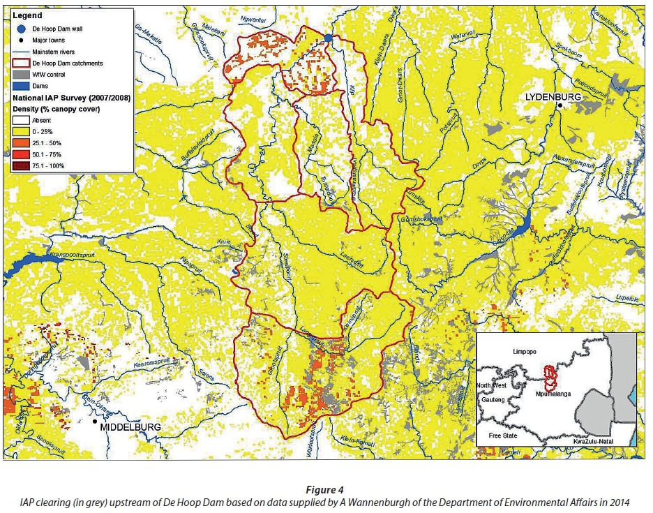
The De Hoop Dam catchment has a high proportion of invadable land, with 82% of it being natural/semi-natural land cover based on Van den Berg et al. (2008). The De Hoop Dam catchment is invaded predominantly by Eucalyptus and wattle (Australian Acacia) species in the riparian zones and Pinus and wattle species in the upland (non-riparian) zones (Kotzé et al., 2010). Since far less clearing has occurred in the De Hoop Dam catchments (Fig. 4) than in the Berg River Dam catchment, it is estimated that 173 638 ha (74% of the invadable area) is invaded by IAPs (Kotzé et al., 2010). These are extensive invasions (17 295 condensed ha) so the estimated clearing costs are high (R287 million). Up to the end of 2013, WfW spent R2.98 million (in 2017 Rand values) over several years clearing the equivalent of 180 condensed ha of IAPs in the De Hoop Dam catchment. Despite being built after the Berg River Dam, the Resources Development Plan of the De Hoop Dam only called for partial IAP clearing (DWAF, 2005).
METHODS
Modelling invasions over time
In each catchment, the current invasion levels are based on data from the National Invasive Alien Plant Survey (NIAPS), which was undertaken in 2007 and 2008 (Kotzé et al., 2010). A key limitation of the NIAPS study is that it was designed for use at a tertiary catchment level and not at the more detailed quaternary level (Kotzé et al., 2010), while the focus of this paper is on invasions at the quaternary level. However, there are no better data available on which to base this comparative study. The NIAPS also excluded all areas with a transformed land cover (for example, cultivated land, urban areas and commercial forest plantations), as these were assumed to be unlikely to become densely invaded (Kotzé et al., 2010). This is a pragmatic assumption - it is well known that such areas can indeed be invaded. In addition, many of these invasions were present in 2000 and could have been mistaken for plantations in the National Land Cover study. The results of the mapping of the IAPs in the dam catchments were given as condensed hectares as calculated from the total invaded area and canopy cover (percent). The density of the invasion can range from one individual per hectare to many thousands of individuals of one or more different species per hectare. As such, the total invaded area is not a useful measure of the long-term full invasion of the area. In order to simplify the calculations of invaded areas for modelling purposes, the invaded area is expressed as condensed hectares, the mathematically equivalent hectares with the density re-scaled to 100% canopy cover (see Eq. 1). Using condensed hectares facilitates comparisons by standardising the different densities of invasions in a given area.
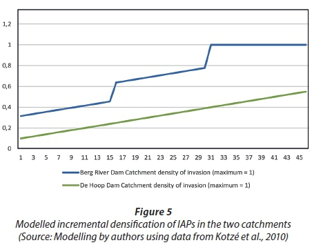
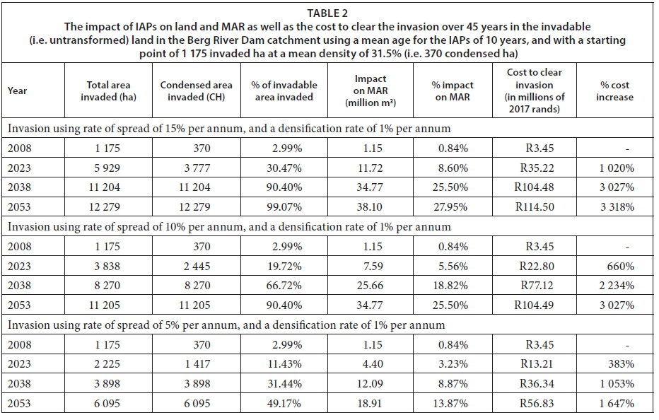
The NIAPS data give no indication of vegetation age. Fires in fynbos occur at 12-15 year intervals between fires but some pines survive fires, especially in the rugged terrain typical of the Berg River Dam catchment, resulting in a mixed age distribution. For the Berg River Dam catchment calculations, we have used two estimates of the mean age of the trees, one based on a mean age of 20 years as used by Le Maitre et al. (2016) and one based on a mean age of 10 years (Scott and Smith, 1997), which is close to the mean age of 7.5 years which would apply if all pines are killed by fires and the mean fire return period is 15 years. We believe that our approach is conservative because aerial photographs from the mid-2000s show that pine invasions were actually far more extensive and denser than estimated by the NIAPS. In the De Hoop catchment the grassland fires are roughly annual but eucalypts survive most fires so we also assumed a mixed age distribution dominated by mature trees.
Modelling of the spread of invasive plants needs to account for two simultaneous processes: (i) an increase in the density within the already invaded area (densification), and (ii) spread from the invaded area to new areas. This study assumed certain IAP annual rates of spread based on existing data (Van Wilgen and Le Maitre, 2013). In reality, the situation is more complex. In the fynbos the main invaders, especially pines, invade non-riparian and riparian areas, but in the grasslands the riparian areas are more susceptible to invasions than non-riparian areas owing to frequent fires which limit recruitment in grasslands (Van Wilgen et al., 2008; Richardson et al., 2007; Decamps et al., 1995). Furthermore, the rate of spread will vary and will be limited, in specific areas, by space and growth requirements of specific species (Kotzé, 2014), and factors such as vulnerability to fire, or disturbance from over-grazing or drought (Van Wilgen, 2009; Le Maitre et al., 2000; Le Maitre et al., 1996). When estimating rates of spread, it is important to distinguish between upland and riparian spread because the additional amount of water lost through invasions in riparian areas is estimated to be 2 to 3 times as high as the same species in non-riparian areas (Le Maitre et al., 2015; Everson et al., 2007; Dye and Jarmain, 2004; Görgens and Van Wilgen, 2004).
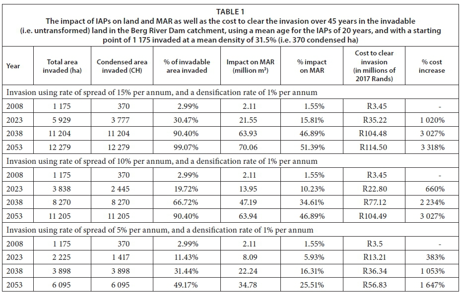
The estimates require projections of the current level of invasions, beginning with the NIAPS survey estimates (Kotzé et al., 2010) of the initial densities and extent. Although these estimates involve some errors and uncertainty which will increase as they are projected into the future, they will not result in a systematic bias. The extent of invasion in each catchment in 2008 was taken as a starting point for projecting the rate of spread and the rate of densification into the future. These were projected for 15, 30 and 45 years into the future (45 years being the accepted lifespan of a dam for planning purposes), assuming that no IAP control operations are carried out, to show the potential levels of invasion. In the Berg River Dam catchment, the National Land Cover Dataset shows that that 13 570 ha (79.0%) of the 17 185 total ha in the catchment were untransformed (natural or semi-natural) (Kotzé et al., 2010). Of the untransformed hectares, 1 175 ha (or 8.7%) were invaded to some degree. Thus, a further 12 395 ha could still be invaded. At a calculated density of 31.5%, the 1 175 ha that were already invaded translates to 370 condensed ha. In the De Hoop catchment about 233 875 ha is natural vegetation of which about 173 638 ha had already been invaded, leaving 60 237 ha that could still be invaded. The mean canopy cover was about 9.95%, giving 17 295 condensed ha of invasions.
For both the Berg River Dam and De Hoop Dam catchments, three rates of spread were used in the modelling of invasions over time. We used 5%, 10% and 15% because they span the likely range, rather than preferring a single rate of spread. The rate of densification in the Berg River Dam catchment has been modelled to increase by 1% per year, but by 40% every 15 years, to simulate the rapid increase in density because of seedling recruitment after wildfires (Fig. 5) (Le Maitre et al., 1996; Richardson and Brown 1986). The rate of densification in the De Hoop Dam catchment has been modelled to increase by 1% per year in both the upland and riparian calculations.
Modelling the impacts of IAPs on water provision
The impact of IAPs on MAR is based on estimates of IAP water usage by Le Maitre et al. (2013). The estimates are based on the specific water impacting IAP species found in the catchments, for example, Pinus species in the Berg River Dam catchment. Although the impact on MAR by the IAPs affects just the section with natural/semi-natural land cover, we have expressed it at the level of the whole catchment because the impacts change the runoff of the whole catchment at the discharge or measurement point, in this case the dam.
The assumption that no control measures will be taken to limit invasions is based on the fact that the clearing of IAPs is currently being done through the Working for Water Programme (WfW), by land-owners, and, very recently, through the application of the Alien and Invasive Species Regulations (DEA, 2014a). These actions provide no guarantee that a specific catchment will be cleared. The policy of WfW is that the budgets necessary to clear IAPs in such catchments, including water weeds, ultimately should come from proceeds generated from the sale of water. These proceeds are currently used to maintain infrastructure such as dams and should also be used to maintain the catchments in a cleared state. However, the present funding from this source is almost exclusively for water weeds (Marais, 2015), and there is no guarantee that it will be increased to cover other species.
As the Berg River Dam catchment was invaded primarily by Pinus species in the upland zone (Kotzé et al., 2010), splitting the calculation for invasion into riparian and upland zones is unnecessary. For the Berg River Dam catchment, pine trees with a mean age of 20 years are estimated to use 5 706 m3/ha per year (Table 1), while pine trees with a mean age of 10 years are estimated to use 3 103 m3/ha per year (Table 2) (Le Maitre et al., 2016; Scott and Smith, 1997). This estimate takes into account the suboptimal growing conditions on the shallow sandstone soils in most of the invadable area (Le Maitre et al., 2013). The reduction is high because of the exceptionally high rainfall that is experienced on the upper slopes and crests of the mountains of this catchment where the pine invasions are located - more than 2 500 mm per year (Schulze et al., 2008) - resulting in a mean MAR for the invadable area of 1 001 mm/yr based on the runoff surface generated by Nel et al. (2017). The MAR reduction was multiplied by the projected condensed invaded area to give the projected reduction for each of the projected spread rates and tree mean ages.
For the De Hoop Dam catchment, the calculations were split into riparian and upland zones, before being combined for catchment totals. This split was necessary because the reduction in MAR caused by IAPs in summer rainfall areas doubles for riparian zones compared to upland zones (Le Maitre et al., 2013; Dzikiti, 2013; Scott et al., 1998). To calculate the impact of IAPs on MAR, the De Hoop Dam catchment was split between the riparian and upland zones using a general principle from Scott et al. (1998) which states that the riparian zone covers about 10% of a catchment on average, while the upland zone covers the remaining 90%. For the riparian zone an estimated optimal reduction of MAR by Eucalyptus of 84 mm/yr (844 m3/ha per year) was used and for the upland zone area an estimated optimal reduction of MAR by pine species of 41 mm/yr (408 m3/ha per year) was used. The flow reductions expressed as a volume per condensed invaded hectare were calculated for the projected riparian and upland invasions for each spread rate. The calculations for the riparian and upland zones were then combined for the catchment totals.
The impact of IAPs on the MAR over 45 years, if the clearing work was not continued, is given as both volumes and as percentage reductions of the MAR. The future level of impact is based on estimates of the current reductions for each of the quaternary catchments, as calculated by the authors, and based on data from Le Maitre et al. (2013).
Modelling the cost of clearing IAPs
Water resource planners need to understand the dynamics of IAP invasions. Clearing IAPs is not a once-off cost and may require repeated follow-ups to deal with the regeneration of the IAPs. The seed banks of many invasive species are stored in the soil and are long-lasting (Van Wilgen, 2009), but in the case of pines and hakea species, seeds are stored in the canopy and do not persist once released (Lamont et al., 1991). A follow-up fire within 2 years of the initial clearing can kill all the seedlings and minimise the need for further, expensive treatments. Furthermore, prevention is better than cure. It can be between 3 and 20 times less expensive to clear a light invasion than a heavy invasion (Marais and Wannenburgh, 2008). It has been shown that, as plants continue to invade watersheds, the costs to clear them increase disproportionately (Cullis et al., 2007; Larsen et al., 2001).
In this paper clearing cost estimates are calculated using condensed hectares and are based on the total cost (initial clearing cost plus the sum of follow-up clearing costs) for 75-100% density (R/ha) given in Table 2 of Marais and Wannenburgh (2008). These costs were chosen because they reported actual (historic) clearing cost and not estimated or modelled costs. The costs given in Marais and Wannenburgh (2008) were in 2008 Rand values and subsequently adjusted to 2017 Rand values using the headline consumer price index (CPI) (Statistics South Africa, 2018). Next we adjusted the costs to reflect the real increase, i.e., the increase in cost above the inflation rate, pertaining to the cost of labour. The average cost per person-day (an ideal day's clearing work, done by 1 person) was estimated in Marais and Wannenburgh (2008) to be R108.76 and was estimated by WfW to be R350 (in 2013 Rand values) (Wannenburgh, 2014). Thereafter we added an additional 20% to the costs as a density contingency (R/ha). The final clearing costs were calculated as R20 019 per condensed hectare of Eucalyptus species IAPs and R 9325 per condensed hectare of Pinus species IAPs.
These costs were calculated for Eucalyptus and Pinus species because, as discussed above, those are the dominant IAPs at the two study sites. For the Berg River Dam catchment, the Pinus species cost was used to calculate the estimated clearing costs, while in the De Hoop Dam catchment the Pinus species cost was used to calculate the estimated clearing costs in the upland parts of the catchment and Eucalyptus species cost was used to calculate the estimated clearing costs in the riparian parts of the catchment. The upland and riparian costs were then combined to provide an estimated cost to clear the whole catchment.
RESULTS
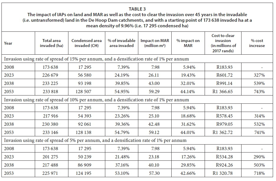
The results show that if clearing is not continued in the Berg River Dam catchment (Table 1), after 45 years, at a 1% densification rate and using the three annual rates of spread (5%, 10% and 15%) and a mean tree age of 20 years, the invasion would increase from 3% to between 49% and 99% of the invadable area of the catchment; flow would be reduced by between 25% and 51%; and the cost to clear the invasion would increase by between 1 647% and 3 318%. Using a mean tree age of 10 years (Table 2), the flow would be reduced by between 13% and 28%. In the De Hoop Dam catchment (Table 3), also using a 1% densification rate and the three annual rates of spread (5%, 10% and 15%), the invasion would increase from 7% to between 53% and 55% of the invadable area of the catchment; flow would be reduced by between 42% and 44%; and the cost to clear the invasion would increase by between 718% and 743%.
The reason for the large difference between the two cases is that at the base year (2008) levels, a substantially greater proportion of the invadable area was already invaded in the De Hoop Dam catchments (173 638 or 74% of the total 233 875 invadable ha) compared to the Berg River Dam catchment (1 175 or 9% of the total 13 570 invadable ha). This can be attributed to the extensive clearing that has taken place in the Berg River Dam catchment. Furthermore, in the Berg River Dam results, the large differences can be attributed to higher rates of spread. The 5%, 10% and 15% rates of spread used in this paper imply doubling times of approximately 14 years, 7 years and 4.67 years, respectively.
DISCUSSION
While a rigorous analysis of the relationship between the spread and density of IAPs would be instructive, the actual values used in this modelling (Table 1, Table 2 and Table 3) are intended to be conservative and illustrative, rather than precise. The purpose is to demonstrate the inevitable outcome of the rapid spread and densification of invasions in areas of natural/semi-natural land cover if ineffective or no management is applied. Whether this happens in 45 years or in shorter or longer periods, ought to be less important to a decision-maker than the fact that it will inevitably occur (without aggressive interventions), and the long-term impacts would nullify any action to augment water supplies with dams.
The results of this paper show the estimated effects of the uncontrolled growth of IAPs on river flows into the dam rather than on yield, which is the potential outflow from the dam. Dams are built to supply water at a 98% level of assurance (i.e. dams are designed to 'fail' or run out of water in 2 out of every 100 years (DWAF, 2004; King et al., 2011)). However, if clearing of IAPs is not done, the estimated impact of IAPs will be a major water security problem over time, as it will decrease yield for a given level of assurance of supply so that these dams will more often 'fail' to deliver the planned yield.
The relationship between yield and MAR is complicated, being directly affected by the volume of the dam relative to the annual inflows, the variability of those inflows and the volumes removed to meet demand (McMahon et al., 2007). However, a reduction in inflows will still have a knock-on effect on yield (Le Maitre and Görgens 2003; Cullis et al., 2007), especially during prolonged droughts when inflows are minimal even though the yield may not be reduced to zero.
The potential negative effects of not timeously clearing IAPs, as shown in the results, or of ineffective clearing (Fill et al., 2017; Kraaij et al., 2017), demonstrate that the authorities cannot afford to allow IAPs to spread, densify and grow as we have projected. They also have to make provision for sufficient funding for the clearing to be properly completed, with invasion densities reduced to less than 5%, or the areas they cannot treat will continue being invaded, as appears be the case with CapeNature and its reserves (Van Wilgen et al. 2016). The water losses are not affordable, and the increases in the cost of clearing are prohibitive. A threshold can be reached whereby the building of a dam without a plan to clear its catchments of IAPs and maintain them in that state, is tantamount to fruitless expenditure. It patently makes sense to have a strategy for clearing IAPs and maintaining the catchment in a cleared state, at the time of commissioning the dam. Not to do so makes as little sense as not budgeting for operational and maintenance costs for the dam itself.
It can also be argued that, without a dam to catch the enhanced MAR from clearing the IAPs, the benefits of clearing would be diluted further. Additionally, the decisions should be made in the context of other costs and benefits, seeking to optimise the outcomes and their impacts. In this regard, the implications of employment opportunities, in particular (given the prioritisation of unemployment, inequity and poverty in the National Development Plan (National Planning Commission, 2012)), but also aspects such as loss of ecosystem services and biodiversity, floods, wetland benefits, intensity of wild fires, erosion, and siltation, should have been put into the decision-making equation.
This analysis points to the importance of evidence brought to bear, and advice offered to Ministers by senior officials. In these cases, a comprehensive strategy for long-term water security in the area could have been developed, rather than only considering a dam. A comparison of the management of IAPs in both cases would have enabled a more fully informed decision to be made.
From a decision-making perspective, information about the immediate and long-term clearing costs and water benefits will best inform what combination of water-mix options to use. This is especially so when longer-term considerations may be factored into the decision-making and both dam construction and IAP clearing are given the go-ahead. In the Berg River Project (when the Berg River Dam was built), clearing of IAPs around the dam was required. To a lesser extent, in Phase 2A of the Olifants River Catchment Resources Development Plan (when the De Hoop Dam was built), partial IAP clearing was required (DWAF, 2005).
While the results of this study show that clearing IAPs in the dam catchments does not result in as much water being made available as does a dam, not or only partially clearing the IAPs would have a severely negative long-term effect on water security (Van Wilgen, 2009). This is especially pertinent since any delays in clearing IAPs in the mountainous areas potentially result in exponential increases in the long-term costs, given the difficulties of clearing in rugged, montane areas.
Decision-makers should also consider that it is possible that a threshold will be reached where it is no longer feasible or affordable, through conventional management practices, to clear catchments (especially mountainous areas) of IAPs (Richardson and Van Wilgen, 2004). If this threshold was reached, biological control (the use of the natural, species-specific enemies of the invasive plants, such as fungi or weevils, introduced into the country with the express purpose of attacking the invasive plants) would remain an opportunity, and would have to be considered along with possible consequences for the plantation industry for certain species (Van Wilgen and De Lange, 2011; De Lange and Van Wilgen, 2010). It would be an ironic reminder of the consequences of not dealing with invasions early were the forestry industry to be at risk for failing to take responsibility for invasions from their plantations.
Finally, the riparian impacts are another important consideration. When water is stored in dams, it is for the use of downstream or water-transfer beneficiaries. Although the bulk of the water from the Berg River Dam is for the City of Cape Town (which has a higher assurance of supply than for agricultural use), part of the storage is for the water-users situated down-river. The dam also releases water to meet the needs of the Ecological Reserve, as well as for towns, farmers and others utilising run-of-river abstraction downstream. With all these competing demands for water, the supply will not continue to exceed demand for long if IAPs are left unmanaged.
What becomes increasingly obvious is that the potential of using catchment management options to improve water resource management has not been effectively realised within the decision-making mechanisms regarding water demand and supply in South Africa. Nor is there any comprehensive retrospective analysis that has been done in South Africa on the efficacy of the management of catchments for water security or, in particular, the full benefits of controlling invading plants despite a large body of evidence on their effects (for example, Le Maitre et al., 2013; Blignaut et al., 2007; Görgens and Van Wilgen, 2004; Marais et al., 2004; Le Maitre and Görgens, ٢٠٠٣; Le Maitre et al., 2000; Van Wilgen et al., 1997).
It would seem that for decision-makers to fully assess the value of, and benefit from, large infrastructure development, additional catchment-based information in essential. Such information would include the benefits of clearing IAPs and the risks associated with failing to clear. Fully informed decisions will be essential for long-term optimal water security in South Africa.
CONCLUSIONS
Water resource planning should not just be about meeting immediate needs or demands; indeed the focus should be on long-term, sustainable supply. Clearing of the 2008 levels of invasive alien plants on their own, i.e., not in combination with other catchment management interventions and demand-side management, could not compensate for the potential water provision and security achieved through building both of the dams in the selected catchments.
However, if the clearing of IAPs is not continued and IAPs are allowed to spread, they will have a substantial impact on MAR in the long term. Given more time, the invasions would continue to increase in size and density. After 45 years of no IAP control and a conservative densification rate of 1%, the MAR is estimated to decrease by between 13% and 28% (for IAPs with a mean age of 10 years), to 25% and 51% (for a mean age of 20 years) in the Berg River Dam catchment, and by between 42% and 44% in the De Hoop Dam catchment. These long-term reductions have major water security implications for their users both locally and downstream. What is more, the impact of climate change, while difficult to quantify, is likely to exacerbate the situation (DEA, 2014b).
It makes no sense to be concerned about long-term water security in the form of building a dam, and yet have no immediate strategy to deal with the risks of being unable to fill that dam and to meet all requirements of the Reserve and dependent human populations (RSA, 1998). It is also clear that delaying the control of IAPs results in greater costs than immediate control, in real terms, so that it makes no sense to defer control.
Balancing water demand and supply in South Africa involves high levels of uncertainty because of inherently variable rainfall with long periods of below-average rainfall. We recommend that the South African Department of Water and Sanitation incorporates multiple alternative options into an overarching solution that embraces catchment management, rather than putting all its efforts to improve water security into the building of dams and inter-basin transfer schemes.
ACKNOWLEDGEMENTS
We would like to gratefully acknowledge Dr Christo Marais, Mr Andrew Wannenburgh and others in the Working for Water Programme, and Mr Ian Kotzé, of the Agricultural Research Council for their assistance, advice and help in the collection of data.
REFERENCES
BLIGNAUT JN, MARAIS C and TURPIE JK (2007) Determining a charge for the clearing of invasive alien plant species (IAPs) to augment water supply in South Africa. Water SA 33 (1) 27-34. [ Links ]
CULLIS J, GÖRGENS A and LYONS S (2007) Review of the selection of acceptable flood capacity for dams in South Africa in the context of dam safety. WRC Report No. 1420/1/07. Water Research Commission, Pretoria. [ Links ]
DE LANGE WJ and VAN WILGEN BW (2010) An economic assessment of the contribution of biological control to the management of invasive alien plants and to the protection of ecosystem services in South Africa. Biol. Invasions 12 (12) 4113-4124. https://doi.org/10.1007/s10530-010-9811-y [ Links ]
DEA (Department of Environmental Affairs, South Africa) (2014a) No. 598: NEMBA alien and invasive species regulations. DEA, Pretoria. [ Links ]
DEA (Department of Environmental Affairs, South Africa) (2014b) Strategic Integrated Project (SIP) 19: ecological infrastructure for water security. Final draft for submission to the Presidential Infrastructure Coordinating Commission: Revision 6.1, 31 October 2014. DEA, Pretoria. [ Links ]
DWAF (Department of Water Affairs and Forestry, South Africa) (2004) National Water Conservation and Water Demand Management Strategy. Department of Water Affairs and Forestry, Pretoria. [ Links ]
DWAF (Department of Water Affairs and Forestry) (2005) Olifants River Water Resources Development Project: Phase 2a - Environmental Impact Assessment: Infrastructure Development Environmental Impact Report. Department of Water Affairs and Forestry, Pretoria. [ Links ]
DWA (DEPARTMENT OF WATER AFFAIRS, SOUTH AFRICA) (2013) National Water Resource Strategy. June 2013 Second Edition. Department of Water Affairs, Pretoria. URL: http://www.dwaf.gov.za/nwrs/LinkClick.aspx?fileticket=u_qFQycClbI%3d&tabid=91&mid=496 (Accessed 10 January 2014). [ Links ]
DYE P and JARMAIN C (2004) Water use by black wattle (Acacia mearnsii): implications for the link between removal of invading trees and catchment streamflow response: Working for Water. S. Afr. J. Sci. 100 (1 & 2) 40-44. [ Links ]
DZIKITI S, SCHACHTSCHNEIDER K, NAIKEN V, GUSH M, and LE MAITRE D (2013a) Comparison of water-use by alien invasive pine trees growing in riparian and non-riparian zones in the Western Cape Province, South Africa. For. Ecol. Manage. 293 92-102. https://doi.org/10.1016/j.foreco.2013.01.003 [ Links ]
DZIKITI S, SCHACHTSCHNEIDER K, NAIKEN V, GUSH M, MOSES G and LE MAITRE DC (2013b) Water relations and the effects of clearing invasive Prosopis trees on groundwater in an arid environment in the Northern Cape, South Africa. J. Arid Environ. 90 103-113. https://doi.org/10.1016/j.jaridenv.2012.10.015 [ Links ]
DZIKITI S, GUSH MB, LE MAITRE DC, MAHERRY AC, JOVANOVIC NZ, RAMOELO A and CHO MA (2016) Quantifying potential water savings from clearing invasive alien Eucalyptus camaldulensis using in situ and high resolution remote sensing data in the Berg River Catchment, Western Cape, South Africa. For. Ecol. Manage. 361 69-80. https://doi.org/10.1016/j.foreco.2015.11.009 [ Links ]
DZVUKAMANJA TN, GÖRGENS AHM, AND JONKER V (2005) Streamflow reduction modelling in water resource analysis. WRC Report No. 1221/1/05, Water Research Commission, Pretoria. [ Links ]
EVERSON CS, CLULOW AD, BECKER M, WATSON A, NGUBO C, BULCOCK H, MENGISTU M, LORENTZ S and DEMLIE M (2014) The long term impact of Acacia mearnsii trees on evaporation, streamflow, low flows and ground water resources. Phase II: Understanding the controlling environmental variables and soil water processes over a full crop rotation. WRC Report No. 2022/1/13. Water Research Commission, Pretoria. [ Links ]
EVERSON C, GUSH M, MOODLEY M, JARMAIN C, GOVENDER M, and DYE P (2007) Effective management of the riparian zone vegetation to significantly reduce the cost of catchment management and enable greater productivity of land resources. WRC Report No. 1284/1/07. Water Research Commission, Pretoria. [ Links ]
FILL JM, FORSYTH GG, KRITZINGER-KLOPPER S, LE MAITRE DC and VAN WILGEN BW (2017) An assessment of the effectiveness of a long-term ecosystem restoration project in a fynbos shrubland catchment in South Africa. J. Environ. Manage. 185 1-10. https://doi.org/10.1016/j.jenvman.2016.10.053 [ Links ]
FORSYTH GG, LE MAITRE DC, SMITH, J and LÖTTER D (2016) Upper Berg River Catchment (G10A) Management Unit control Plan. Report No. CSIR/NRE/ECOS/ER/2016/0037/B, Natural Resources and the Environment, CSIR, Stellenbosch. [ Links ]
GÖRGENS AHM and VAN WILGEN BW (2004) Invasive alien plants and water resources in South Africa: current understanding, predictive ability and research challenges. S. Afr. J. Sci. 100 (1&2) 27-33. [ Links ]
IUCN (International Union for the Conservation of Nature) (2000) Guidelines for the prevention of biodiversity loss caused by alien invasive species. IUCN, Gland, Switzerland. [ Links ]
KING J, MITCHELL S and PIENAAR H (2011) Water supply and demand. In King J and Pienaar H (eds) Sustainable use of South Africa's Inland Waters. WRC Report No. TT 491/11. Water Research Commission, Pretoria. [ Links ]
KOTZÉ I (2014). Personal communication, 22 September 2014. Dr Ian Kotzé, Agricultural Research Council - Institute for Soil, Climate and Water, Private Bag X79, Pretoria, South Africa, 0001. [ Links ]
KOTZÉ I, BEUKES H, VAN DER BERG E and NEWBY T (2010) National invasive alien plant survey. ARC Report No. GW/A/2010/21. Agricultural Research Council, Institute for Soil, Climate and Water, Pretoria. [ Links ]
KRAAIJ T, BAARD JA, RIKHOTSO DR, COLE NS and VAN WILGEN BW (2017) Assessing the effectiveness of invasive alien plant management in a large fynbos protected area. Bothalia 47 (2) 1-11. https://doi.org/10.4102/abc.v47i2.2105 [ Links ]
LAMONT BB, LE MAITRE DC, COWLING RM and ENRIGHT NJ (1991) Canopy seed storage in woody plants. Bot. Rev. 57 277-317. https://doi.org/10.1007/BF02858770 [ Links ]
LARSEN EJ, MARAIS C and GÖRGENS AHM (2001) Water resources planning with recognition of alien vegetation eradication. Tenth South African National Hydrological Symposium 26-28 September 2001. URL: https://www.dwa.gov.za/wfw/docs/Larsenetal.,%202001.pdf (Accessed 2 May 2014). [ Links ]
LE MAITRE DC and GÖRGENS AHM (2003) Impact on invasive alien vegetation on dam yields. WRC Report No. KV 141/03. Water Research Commission, Pretoria. [ Links ]
LE MAITRE DC (2004) Predicting invasive species impacts on hydrological processes: the consequences of plant physiology for landscape processes. Weed Technol. 18 (1) 1408-1410. https://doi.org/10.1614/0890-037X(2004)018[1408:PISIOH]2.0.CO;2 [ Links ]
LE MAITRE DC, MANDER M and DINI J (2009) Watershed Management. Appendix to the Environment Chapter in the Water for Growth and Development Framework. Internal DWAF Report. Department of Water Affairs and Forestry, Pretoria. [ Links ]
LE MAITRE DC, FORSYTH G, DZIKITI S and GUSH M (2013) Estimates of the impacts of invasive alien plants on water flows in South Africa. CSIR Report No. CSIR/NRE/ECO/ER/2013/0067/B. Council for Scientific and Industrial Research, Stellenbosch. https://doi.org/10.4314/wsa.v42i4.17 [ Links ]
LE MAITRE DC, FORSYTH GG, GUSH MB and DZIKITI S (2016) Estimates of the impacts of invasive alien plants on water flows in South Africa. Water SA 42 659-672. [ Links ]
LE MAITRE DC, GUSH MB and DZIKITI S (2015) Impacts of invading alien plant species on water flows at stand and catchment scales. Annals of Botany Plants, plv043. URL: http://aobpla.oxfordjournals.org/content/early/2015/04/29/aobpla.plv043.full.pdf (Accessed 3 June 2015). [ Links ]
LE MAITRE DC, VAN WILGEN BW, CHAPMAN RA and MCKELLY D (1996) Invasive plants and water resources in the Western Cape Province, South Africa: modelling the consequences of a lack of management. J. Appl. Ecol. 33 161-172. https://doi.org/10.2307/2405025 [ Links ]
LE MAITRE DC, VAN WILGEN BW, GELDERBLOM CM, BAILEY C, CHAPMAN RA and NEL JA (2002) Invasive alien trees and water resources in South Africa: case studies of the costs and benefits of management. For. Ecol. Manage. 160 143-159. https://doi.org/10.1016/S0378-1127(01)00474-1 [ Links ]
MARAIS C, VAN WILGEN BW and STEVENS D (2004) The clearing of invasive alien plants in South Africa: a preliminary assessment of costs and progress: working for water. S. Afr. J. Sci. 100 (1 & 2) 97-103. [ Links ]
MARAIS C and WANNENBURGH AM (2008) Restoration of water resources (natural capital) through the clearing of invasive alien plants from riparian areas in South Africa - costs and water benefits. S. Afr. J. Bot. 74 (3) 526-537. https://doi.org/10.1016/j.sajb.2008.01.175 [ Links ]
MARAIS C (2015) Personal Communication, 3 April 2015. Dr Christo Marais, Department of Water & Sanitation, Directorate: Working for Water, Private Bag X4390, Cape Town 8000, South Africa. [ Links ]
MATTHEWS S (2006) Modelling, monitoring nuts & bolts of dam project. Water Wheel March/April 2006 29-31. [ Links ]
MCMAHON TA, PEGRAM GGS, VOGEL RM and PEEL MC (2007) Revisiting reservoir storage-yield relationships using a global streamflow database. Adv. Water Resour. 30 1858-1872. https://doi.org/10.1016/j.advwatres.2007.02.003. [ Links ]
MIDDLETON BJ and BAILEY AK (2008) Water Resources of South Africa: 2005 Study (WR2005). WRC Report No. TT381/08. Water Research Commission, Pretoria. [ Links ]
MILTON SJ and DEAN WRJ (2010) Plant invasions in arid areas: special problems and solutions: a South African perspective. Biol. Invasions 12 (12) 3935-3948. https://doi.org/10.1007/s10530-010-9820-x [ Links ]
NEL J, COLVIN C, LE MAITRE D and SMITH J (2013) Strategic water source areas. CSIR Report No. CSIR/NRE/ECOS/ER/2013/0031/A. Natural Resources and the Environment, Council for Scientific and Industrial Research, Stellenbosch. [ Links ]
NEL JL, LE MAITRE DC, ROUX DJ, COLVIN C, SMITH JS, SMITH-ADAO LB, MAHERRY A and SITAS N (2017) Strategic water source areas for urban water security: Making the connection between protecting ecosystems and benefiting from their services. Ecosyst. Services 28 251-259. https://doi.org/10.1016/j.ecoser.2017.07.013 [ Links ]
RICHARDSON DM and BROWN PJ (1986) Invasion of mesic mountain fynbos by Pinus radiata. S. Afr. J. Bot. 52 529-536. https://doi.org/10.1016/S0254-6299(16)31486-7 [ Links ]
RICHARDSON DM and VAN WILGEN BW (2004) Invasive alien plants in South Africa: how well do we understand the ecological impacts. S. Afr. J. Sci. 100 (1 & 2) 45-52. [ Links ]
RICHARDSON DM, HOLMES PM, ESLER KJ, GALATOWITSCH SM, STROMBERG JC, KIRKMAN SP, PYŠEK P and HOBBS RJ (2007) Riparian vegetation: degradation, alien plant invasions, and restoration prospects. Divers. Distrib. 13 (1) 126-139. https://doi.org/10.1111/j.1366-9516.2006.00314.x [ Links ]
RSA (Republic of South Africa) (1998) National Water Act: Act No. 36 of 1998. Government Gazette 19182. Government Printer, Cape Town. [ Links ]
SCHULZE RE, MAHARAJ M, WARBURTON ML, HORAN MJC, KUNZ, RP and CLARK DJ (2008) South African atlas of climatology and agrohydrology. WRC Report No. 1489/1/08. Water Research Commission, Pretoria. [ Links ]
SCOTT DF and LESCH W (1997) Streamflow responses to afforestation with Eucalyptus grandis and Pinus patula and to felling in the Mokobulaan experimental catchments, South Africa. J. Hydrol. 199 360-377. https://doi.org/10.1016/S0022-1694(96)03336-7 [ Links ]
SCOTT DF and SMITH RE (1997) Preliminary empirical models to predict reductions in total and low flows resulting from afforestation. Water SA 23 135-140. [ Links ]
SCOTT DF, LE MAITRE DC and FAIRBANKS DHK (1998) Forestry and streamflow reductions in South Africa: A reference system for assessing extent and distribution. Water SA 24 187-199. [ Links ]
STATISTICS SOUTH AFRICA (2018) CPI history: Table B1 - CPI headline index numbers (Dec 2016 = 100) URL: http://www.statssa.gov.za/publications/P0141/CPIHistory.pdf [Accessed 7 May 2018]. [ Links ]
VAN DEN BERG EC, PLARRE C, VAN DEN BERG HM and THOMPSON MW (2008) The South African National Land Cover 2000. Unpublished ARC Report No. GW/A/2008/86. Agricultural Research Council, Institute for Soil, Climate and Water, Pretoria, South Africa. [ Links ]
VAN WILGEN BW (2009) The evolution of fire and invasive alien plant management practices in fynbos. S. Afr. J. Sci. 105 (9-10) 335-342. https://doi.org/10.4102/sajs.v105i9/10.106. [ Links ]
VAN WILGEN BW and DE LANGE WJ (2011) The costs and benefits of biological control of invasive alien plants in South Africa. Afr. Entomol. 19 (2) 504-514. https://doi.org/10.4001/003.019.0228 [ Links ]
VAN WILGEN BW and LE MAITRE DC (2013) Rates of spread in invasive alien plants in South Africa. Unpublished CSIR Report No. CSIR/NRE/ECOS/ER/2013/0107A. Council for Scientific and Industrial Research, Stellenbosch, South Africa. [ Links ]
VAN WILGEN BW and RICHARDSON DM (2014) Challenges and trade-offs in the management of invasive alien trees. Biol. Invasions 16 (3) 721-734. https://doi.org/10.1007/s10530-013-0615-8 [ Links ]
VAN WILGEN BW, FILL JM, BAARD JA, CHENEY C, FORSYTH AT and KRAAIJ T (2016) Historical costs and projected future scenarios for the management of invasive alien plants in protected areas in the Cape Floristic Region. Biol. Conserv. 200 168-177. https://doi.org/10.1016/j.biocon.2016.06.008. [ Links ]
VAN WILGEN BW, LITTLE PR, CHAPMAN RA, GORGENS AHM, WILLEMS T and MARAIS C (1997) The sustainable development of water resources: history, financial costs, and benefits of alien plant control programmes. S. Afr. J. Sci. 93 (9) 404-411. [ Links ]
VAN WILGEN BW, REYERS B, LE MAITRE DC, RICHARDSON DM and SCHONEGEVEL L (2008) A biome-scale assessment of the impact of invasive alien plants on ecosystem services in South Africa. J. Environ. Manage. 89 (4) 336-349. https://doi.org/10.1016/j.jenvman.2007.06.015 [ Links ]
WANNENBURGH A (2014). Personal communication, 17 October 2014. Mr Andrew Wannenburgh, Department of Water Affairs and Forestry, Directorate: Working for Water, Private Bag X4390, Cape Town 8000, South Africa. [ Links ]
ZHANG L, DAWES WR, and WALKER GR (2001) Response of mean annual evapotranspiration to vegetation changes at catchment scale. Water Resour. Res. 37 701-708. https://doi.org/10.1029/2000WR900325 [ Links ]
Received 6 July 2016
Accepted in revised form 25 September 2018
* To whom all correspondence should be addressed. e-mail: preston.irfsa@gmail.com

