


Servicios Personalizados
Articulo
 Inglés (pdf)
 Articulo en XML
 Referencias del artículo
Indicadores

Links relacionados
-
 Citado por Google
 -
 Similares en Google
Compartir

 Permalink
Water SA
versión On-line ISSN 1816-7950
versión impresa ISSN 0378-4738
Water SA vol.43 no.3 Pretoria jul. 2017
http://dx.doi.org/10.4314/wsa.v43i3.14
A modified version of the SMAR model for estimating root-zone soil moisture from time-series of surface soil moisture
Farid FaridaniI; Alireza FaridI, *; Hossein AnsariI; Salvatore ManfredaII
IDepartment of Water Engineering, Ferdowsi University of Mashhad, Azadi Square, Mashhad, Iran
IIDipartimento delle Culture Europee e del Mediterraneo: Architettura, Ambiente, Patrimoni Culturali (DiCEM), Università degli Studi della Basilicata, via dell'Ateneo Lucano, 10, 85100 Potenza, Italy
ABSTRACT
Root-zone soil moisture at the regional scale has always been a missing element of the hydrological cycle. Knowing its value could be a great help in estimating evapotranspiration, erosion, runoff, permeability, irrigation needs, etc. The recently developed Soil Moisture Analytical Relationship (SMAR) can relate the surface soil moisture to the moisture content of deeper layers using a physically-based formulation. Previous studies have proved the effectiveness of SMAR in estimating root-zone soil moisture, yet there is still room for improvement in its application. For example, the soil water loss function (i.e. deep percolation and evapotranspiration), assumed to be a linear function in the SMAR model, may produce approximations in the estimation of water losses in the second soil layer. This problem becomes more critical in soils with finer textures. In this regard, the soil moisture profile data from two research sites (AMMA and SCAN) were investigated. The results showed that after a rainfall event, soil water losses decrease following a power pattern until they reach a minimum steady state. This knowledge was used to modify SMAR. In particular, SMAR was modified (MSMAR) by introducing a non-linear soil water loss function that allowed for improved estimates of root zone soil moisture.
Keywords: surface soil moisture, root-zone soil moisture, SMAR, soil water loss function, MSMAR
INTRODUCTION
The moisture content of the vadose zone plays an important role in many water- and energy- related studies, numerical weather predictions, global change modelling, prediction of surface runoff, and evaporation modelling (Holmes et al., 2009; Brocca et al., 2010; Manfreda and Fiorentino, 2008; Manfreda et al., 2010; Parinussa et al., 2012). Soil moisture can help us to understand the interaction between land and atmosphere as it determines the partitioning of energy between the different water fluxes. However, the in-situ measurement of soil moisture, even for small watersheds, is often time-consuming and requires a large effort to adequately sample.
In previous research, description of an analytical relationship between the soil moisture at the surface and that in the lower soil layers has been emphasized as a significant challenge (Ochsner et al., 2013). Wagner et al. (1999) suggested the use of an exponential filter and a recession constant (T) to convert the time series of surface measurements to a signal that is able to capture the dynamics of the lower soil layer. The great advantage of this model is its simplicity, due to using only one parameter (i.e., T) and because the derived soil moisture index (SWI) relies only on surface observation. This approach has been tested with both simulated and measured data, and has been extensively used to improve the description of root-zone soil moisture in rainfall-runoff applications (e.g., Manfreda et al., 2011; Brocca et al., 2010, 2012; Matgen et al., 2012). Despite numerous efforts to find a physical interpretation for the parameter T (e.g. Ceballos et al., 2005; De Lange et al., 2008; Albergel et al., 2008) that is influenced by a number of physical processes controlling soil moisture fluctuations, researchers did not observe significant relationships between T and the main soil properties (clay and sand fractions, bulk density and organic matter content).
The recently developed Soil Moisture Analytical Relationship (SMAR) was derived from a simplified soil water balance equation for arid and semi-arid environments that provides a relationship between root-zone and surface soil moisture. Results have proved the potential of this model to estimate root-zone soil moisture. Applications of the SMAR model in estimating root-zone soil moisture (RZSM) from a time series of surface soil moisture (SSM), at both local and regional scales, have proved the capability of this methodology in providing a good description of RZSM (e.g., Manfreda et al., 2014; Faridani et al., 2016; Baldwin et al., 2016). The advantage of the SMAR model over the SWI method is that there are clear physical interpretations for the SMAR parameters which can be easily determined knowing soil texture and climate of the target location. In the original model proposed by Manfreda et al. (2014), the water loss function was assumed to be a linear function, but they suggested improving the SMAR model by representing a soil water loss function that accounts for the non-linearity of this process. This study therefore aimed to discover the water loss pattern of the root zone after a rainfall event in order to modify the SMAR model, using two different soil databases, i.e., in Africa and North America (the AMMA and SCAN networks, respectively).
SOIL MOISTURE DATA
In-situ sites: the AMMA database
The African Monsoon Multidisciplinary Analysis (AMMA) programme, which started in 2004, has developed a network of ground-based stations in sub-Saharan West Africa (see Redelsperger et al., 2006). In this study, we focused on the point measurements of soil moisture taken at the sites of Belenfougou, Wankama and Tondikiboro in Niger.
These sites have a semi-arid climate characterized by limited rainfall that is generally concentrated in time. The mean annual rainfall reaches a value of about 550 mm (AMMA-CATCH, 2014).
At each site, soil moisture data were collected at 5 different depths (5, 10, 40, 70, 100 and 135 cm) using water content reflectometers (CS616 - Campbell Scientific Inc., Logan, Utah, USA) placed along the soil column with the geometry schematically described in Fig. 1. Similar to Manfreda et al. (2014), the relative saturation at 5 cm depth was considered as a reference surface measurement, and the relative saturation over the root zone was estimated by averaging the soil moisture measurements below the surface layer. The AMMA database and other soil moisture products from other projects have been collected in the International Soil Moisture Network (ISMN) database (e.g. Dorigo et al., 2011 - available at: http://ismn.geo.tuwien.ac.at).

In-situ sites: the SCAN database
The Soil Climate Analysis Network (SCAN) consists of more than 190 stations in the United States (US) with a variety of climatic, geological and vegetation conditions (e.g. Schaefer et al., 2007). Measurements are collected by dielectric devices at 5, 10, 20, 50, and 100 cm depth. The selected stations were: Widow Wells and Cross Roads in New Mexico; Enterprise in Utah; and Mammoth Cave and Princeton#1 in Kentucky, US. The pedological report on the SCAN website allowed for definition of the soil texture characteristics of the first (the first 10 cm) and the second layer of soil (assumed equal to the remaining 90 cm), which can be used to derive soil parameters for each site.
MATERIALS AND METHODS
The SMAR Model
Manfreda et al. (2014) assumed that soil was composed of 2 layers: one surface layer with a depth of a few centimetres (equivalent to the retrieval depth of the satellite sensor) and a second layer below with a depth corresponding to the rooting depth of the vegetation. Infiltration is the most relevant water mass exchange between the two layers and other processes such as lateral flow and capillary rise are assumed negligible. The water flux from the top layer can be considered significant only when the soil moisture exceeds field capacity. Assuming that the soil moisture movement from the upper to the lower layer during a rainfall event can be modelled following the Green-Ampt equation (Green and Ampt, 1911), one can also assume that all water in the first layer above field capacity will move into the lower layer within 1 day. Under such assumptions, Eq. 1 describes the instantaneous infiltration flux from the top layer to the lower layer. Therefore, infiltration is:

where: y(t) is the fraction of soil saturation infiltrating in the lower layer, n1 is the soil porosity of the top layer, Zr1 [L] is the depth of the top layer, s1 (θ1/n1) is the relative saturation of the first layer (given by the ratio between the soil water content, θ1, and the porosity, n1, of the top layer), and sc1 is the value of relative saturation at field capacity of the top layer of soil.
In order to avoid the underestimation of infiltration, the surface-soil moisture value should be referred for the first 5-10 cm of soil. Most satellite sensors cannot observe deeper than a few centimetres, but it is a reasonable assumption that these measures can be representative of the dynamics of a surface layer of approximately 5-10 cm (Manfreda et al., 2014). SMAR assumes that the soil water losses decrease linearly, from a maximum value under well-watered conditions to zero at the wilting point.
Soil water balance can be described by defining x2 = (s2 - sw2)/(1 − sw2) as the 'effective' relative soil saturation of the second soil layer and w0 = (1 - sw2) n2Zr2 as the soil water storage. Eq. 2 describes the soil water balance which Manfreda et al. (2014) used in the SMAR model.

where: s2 is the relative saturation of the soil, sw2 represents the relative saturation at the wilting point, n2 is the soil porosity, Zr2 [L] is the soil depth, V2 [LT−1] is the soil water loss coefficient accounting for both evapotranspiration and percolation losses, and x2 is the 'effective' relative soil saturation of the second soil layer. The model was developed mainly for an arid and semi-arid climate with flat surfaces and neglecting the presence of phreatic surfaces, effects due to topographic convergence (e.g. subsurface flows), the presence of frozen soils, etc. (Manfreda et al., 2014).
The equation above can be simplified using normalized coefficients a and b defined as:
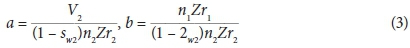
The value of these parameters can be related to the ratio of the depths of the two layers and the soil water loss coefficient. Therefore, the soil water balance equation becomes:

Equation 4 shows a generalization that includes the proposed case by Wagner et al. (1999). Manfreda et al. (2014) assumed an initial condition for the relative saturation x2(t) equal to zero and derived an analytical solution to this linear differential equation:

For practical applications, the discrete form of Eq. 5 may also be needed:

Expanding Eq. 6 and assuming ∆t = (tj - t(j−1)), one may derive the following expression for the soil moisture in the second layer based on the time series of surface soil moisture:

This may be rewritten as a function of s2 as:

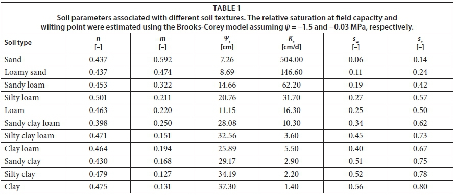
Parameters sw2, sc1, a, and b can be estimated from the soil texture, the soil depth, and the soil water losses (Table 1). The parameter a is a function of potential evapotranspiration and soil permeability which can be estimated by regression functions such as those proposed by Pan et al. (2003).
In SMAR, the soil water loss function is a simple linear function with parameter V2 that can be written as:

Such a formulation represents an approximation, leading to errors, especially in clay soils or humid environments where non-linear processes become dominant. The objective of the present study was to test the potential improvements that can be obtained with a new, more realistic, loss function.
Modification of SMAR
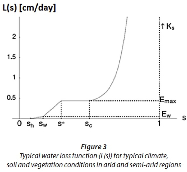
The soil water loss function is assumed to be linear in the SMAR model. However, by plotting the water losses against the days since the last precipitation, it was observed that soil water losses exhibit nonlinear behaviour in the days after rainfall (Fig. 2). As Laio et al. (2001) suggested, soil water loss (i.e. evapotranspiration and deep percolation) is a non-linear function influenced by soil permeability and local climate.
Laio et al. (2001) assumed that leakage is at its maximum when soil is saturated and then rapidly decreases as the soil dries out, following the decrease in hydraulic conductivity Ks. They assumed that the hydraulic conductivity decreases exponentially from Ks at s2 = 1 to zero at field capacity sC2. Thus, the behaviour of leakage losses is described as:

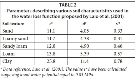
where: c = 2d + 4 and d is an experimentally determined parameter of the soil-water retention curve suggested by Clapp and Hornberger (1987). The values of parameters c and d for different soil textures are provided in Table 2.
The evapotraspiration (ET) is calculated by:
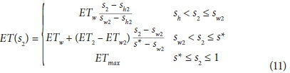
where: sh and s* are soil saturations at hygroscopic scale and stomata closure, respectively. s* depends on both vegetation and soil characteristics (Laio et al., 2001).
Thus, the soil water loss function becomes:

where: DP(s2) is the amount of deep percolation at s2. An example of such formulation is given in Fig. 3.
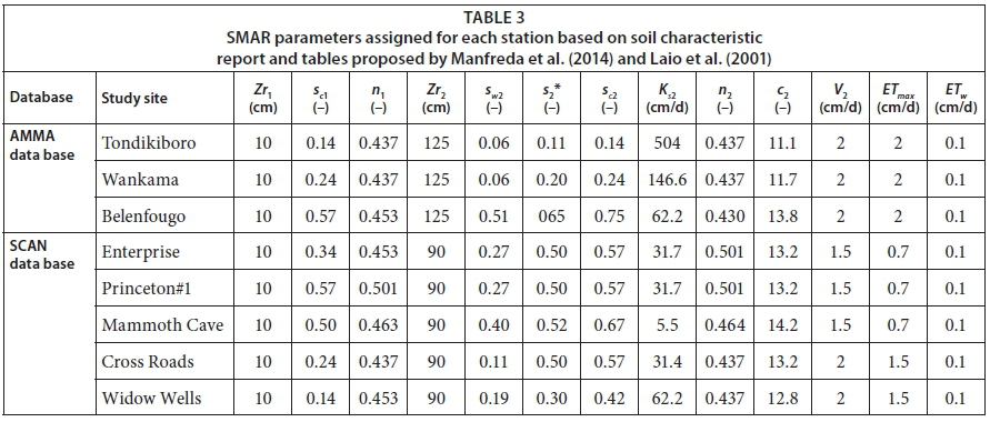
Soil texture, surface layer (Zr1) and root-zone layer (Zr2) were determined based on the soil characteristic report of study sites. According to the defined texture for each station, parameters sc1, sw2, sc2, a, b and Ks2 were determined from Table 1 and parameters: c2 and s*2 were determined from Table 2. Finally, parameters: V2, ETmax and ETw were determined according to the climate of study areas. Table 3 shows all the mentioned parameters for all the studied field sites.
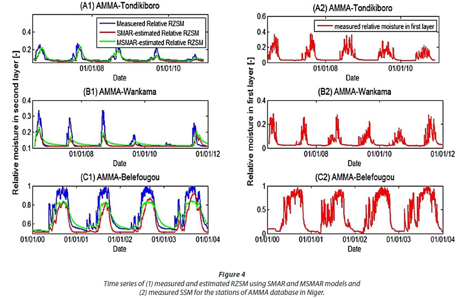
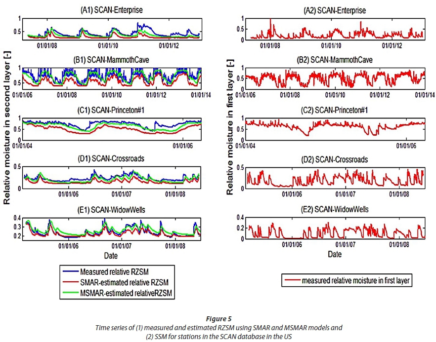
The SMAR model was modified by substituting the water loss coefficient with Eq. 12. Then the time series of surface soil moisture was applied in both the SMAR model and modified SMAR model (hereafter referred to as MSMAR). The time series of surface soil moisture (SSM), measured RZSM and estimated RZSM for the study sites are depicted in Figs 4 and 5.
As can be seen in Fig. 4 A2, B2 and C2, the rainfall pattern in the AMMA study area has two distinct dry and wet seasons which causes very clear rises and abrupt decreases in the soil water content of both surface and root-zone layers. This is mainly due to the high permeability of soil that is mainly characterized by a coarse texture. Looking at Fig. 4 A1 and B1, one can see that both the SMAR and MSMAR models had similar RZSM estimates in Tondikiboro and Wankama Stations. Because of the pure sandy textures of the soil at these stations, the MSMAR water loss function (Eq. 12) becomes almost equal to the water loss function proposed by the SMAR model, which will ultimately give similar results for the two models. Nevertheless, the MSMAR estimates of RZSM become significantly better when moving from coarse to finer textures. This can be seen for Belenfougou Station where the soil is finer (Fig. 4-C1).
As depicted by Fig. 5, MSMAR outperformed SMAR in the estimation of RZSM for most of the SCAN sites. In general, SMAR tends to underestimates RZSM in finer soil textures. Considering the spatial and climatic diversity of the locations where the soil profile saturation has been measured, results show that the proposed modifications improve modelling performance.
In order to evaluate the accuracy of both the SMAR and MSMAR models, the mean absolute error (MAE), root mean square error (RMSE) and correlation coefficient (R) between measured and modelled RZSM values for each station were calculated (Table 4). In all stations except Widow-Wells, the MSMAR model had a lower RMSE than that of the SMAR model. Also, in terms of the correlation coefficient (R), for all stations except Wankama, MSMAR had better and/or equal correlations with the measured RZSM than that of the SMAR model (Table 4). Therefore, the MSMAR model may represent a good alternative in the estimation of RZSM.
DISCUSSION AND CONCLUSIONS
In this study, the performance of the SMAR model in estimation of root zone soil moisture (RZSM) was investigated. The soil water loss function of the SMAR model was originally assumed to be a linear function for a given day. Since soils with finer textures have higher holding capacity and lower infiltration capacity, assuming such a linear relationship may lead to errors in the evaluation of soil water losses.
By plotting measured soil water losses (the difference between RZSM of the current and previous days) vs. the number of days since the last precipitation for each day, soil water loss was shown to be strongly non-linear over time. Thus SMAR was modified (MSMAR) by substituting the water loss coefficient with the soil water loss function proposed by Laio et al. (2001), the parameters of which can be determined by knowledge of soil characteristics.
The performance of the SMAR and MSMAR models were evaluated by comparing RMSE and R values between measured and estimated RZSM values. The results showed that, in general, the MSMAR model improved the estimation of RZSM from the time series of surface soil moisture measurement. Nevertheless, these models had similar results in very coarse textured soils.
Since both the SMAR and MSMAR models use the moisture of the top few centimetres of the soil to estimate the root zone soil moisture, it is suggested that the possibility of assimilating satellite soil moisture data into these two models be evaluated.
ACKNOWLEDGMENTS
The authors wish to acknowledge Ferdowsi University of Mashhad for granting this research under the number 31317, and to thank the University of Basilicata for providing the opportunity for this collaboration.
REFERENCES
ALBERGEL C, RUDIGER C, PELLARIN T, CALVET JC, FRITZ N, FROISSARD F and MARTIN E (2008) From near-surface to root-zone soil moisture using an exponential filter: an assessment of the method based on in-situ observations and model simulations. Hydrol. Earth Syst. Sci. 12 (1) 1323-1337. https://doi.org/10.5194/hess-12-1323-2008 [ Links ]
BALDWIN D, MANFREDA S, KELLER K and SMITHWICK EAH (2017) Predicting root zone soil moisture with soil properties and satellite near-surface moisture data across the conterminous United States. J. Hydrol. 546 393-404. https://doi.org/10.1016/j.jhydrol.2017.01.020 [ Links ]
BROCCA L, MELONE F, MORAMARCO T, WAGNER W, NAEIMI V, BARTALIS Z and HASENAUER S (2010) Improving runoff prediction through the assimilation of the ASCAT soil moisture product. Hydrol. Earth Syst. Sci. 14 (10) 1881-1893. https://doi.org/10.5194/hess-14-1881-2010 [ Links ]
BROCCA L, MAROMARCO T, MELONE F, WAGNER W, HASENAUER S and HAHN S (2012) Assimilation of surface-and root-zone ASCAT soil moisture products into rainfall-runoff modeling. IEEE Trans. Geosci. Remote Sens. 50 (7) 2542-2555. https://doi.org/10.1109/TGRS.2011.2177468 [ Links ]
CEBALLOS A, SCIPAL K, WAGNER W and MARTINEZ-FERNANDEZ J (2005) Validation of ERS scatterometer‐derived soil moisture data in the central part of the Duero Basin Spain. Hydrol. Process. 19 (8) 1549-1566. https://doi.org/10.1002/hyp.5585 [ Links ]
CLAPP RB and HORNBERGER GM (1978) Empirical equations for some soil hydraulic properties. Water Resour. Res. 14 (4) 601-604. https://doi.org/10.1029/WR014i004p00601 [ Links ]
DE LANGE R, BECK R, VAN DE GIESEN N, FRIESEN J, DE WIT A and WAGNER W (2008) Scatterometer-derived soil moisture calibrated for soil texture with a one-dimensional water-flow model. IEEE Trans. Geosci. Remote Sens. 46 (12) 4041-4049. https://doi.org/10.1109/TGRS.2008.2000796 [ Links ]
DORIGO WA, WAGNER W, HOHENSINN R, HAHN S, PAULIK C, XAVER A, GRUBER A, DRUSCH M, MECKLENBURG S, OEVELEN PV and ROBOCK A (2011) The International Soil Moisture Network: a data hosting facility for global in situ soil moisture measurements. Hydrol. Earth Syst. Sci. 15 (5) 1675-1698. https://doi.org/10.5194/hess-15-1675-2011 [ Links ]
FARIDANI F, FARID A, ANSARI H and MANFREDA S (2016) Estimation of the root-zone soil moisture using passive microwave remote sensing and SMAR Model. J. Irrig. Drain Eng. 04016070. [ Links ]
GREEN WH and AMPT GA (1911) Studies on soil phyics. J. Agric. Sci. 4 (1) 1-24. https://doi.org/10.1017/S0021859600001441 [ Links ]
ISMN (International Soil Moisture Network) (2014) The ISMN Data Portal. URL: http://ismn.geo.tuwien.ac.at (Last accessed December 2014). [ Links ]
LAIO F, PORPORATO A, RIDOLFI L and RODRIQUEZ-ITURBE I (2001) Plants in water-controlled ecosystems: active role in hydrologic processes and response to water stress: II Probabilistic soil moisture dynamics. Adv. Water Res. 24 (7) 707-723. https://doi.org/10.1016/S0309-1708(01)00005-7 [ Links ]
MANFREDA S and FIORENTINO M (2008) A stochastic approach for the description of the water balance dynamics in a river basin. Hydrol. Earth Syst. Sci. 12 (5) 1189-1200. https://doi.org/10.5194/hess-12-1189-2008 [ Links ]
MANFREDA S, SCANLON TM and CAYLOR KK (2010) On the importance of accurate depiction of infiltration processes on modelled soil moisture and vegetation water stress. Ecohydrology 3 (2) 155-165. [ Links ]
MANFREDA S, LACAVA T, ONORATI B, PERGOLA N, LEO MD, MARGIOTTA MR and TRAMUTOLI V (2011) On the use of AMSU-based products for the description of soil water content at basin scale. Hydrol. Earth Syst. Sci. 15 (9) 2839-2852. https://doi.org/10.5194/hess-15-2839-2011 [ Links ]
MANFREDA S, BROCCA L, MARAMARCO T, MELONE F and SHEFFIELD J (2014) A physically based approach for the estimation of root-zone soil moisture from surface measurements. Hydrol. Earth Syst. Sci. 18 (3) 1199-1212. https://doi.org/10.5194/hess-18-1199-2014 [ Links ]
MATGEN P, HEITZ S, HASENAUER S, HISSLER C, BROCCAL L, HOFFMANN L and SAVENIJE HHG (2012) On the potential of MetOp ASCAT‐derived soil wetness indices as a new aperture for hydrological monitoring and prediction: a field evaluation over Luxembourg. Hydrol. Process. 26 (15) 2346-2359. https://doi.org/10.1002/hyp.8316 [ Links ]
OCHSNER TE, COSH MH, CUENCA RH, DORIGO WA, DRAPER CS, HAGIMOTO Y and ZREDA M (2013) State of the art in large-scale soil moisture monitoring. Sci. Soc. Am. J. 77 (6) 1888-1919. https://doi.org/10.2136/sssaj2013.03.0093 [ Links ]
PAN F, PETERS‐LIDARD CD and SALE MJ (2003) An analytical method for predicting surface soil moisture from rainfall observations. Water Resour. Res. 39 (11). https://doi.org/10.1029/2003WR002142 [ Links ]
Received 8 May 2016
Accepted in revised form 3 July 2017
* To whom all correspondence should be addressed: email: farid-h@ferdowsi.um.ac.ir

