


Servicios Personalizados
Articulo
 Inglés (pdf)
 Articulo en XML
 Referencias del artículo
Indicadores

Links relacionados
-
 Citado por Google
 -
 Similares en Google
Compartir

 Permalink
Potchefstroom Electronic Law Journal (PELJ)
versión On-line ISSN 1727-3781
PER vol.25 no.1 Potchefstroom 2022
http://dx.doi.org/10.17159/1727-3781/2022/v25i0a13483
SARCHI CLES SERIES ON CITIES, LAW AND ENVIRONMENTAL SUSTAINABILITY
Some Legal Options to Ensure the Protection of South Africa's Utilisable Groundwater Resources
INorth-West University, South Africa
IICarin Bosman Sustainable Solutions, South Africa. Email: Germarie.Viljoen@nwu.ac.za; carin@cbss.co.za
ABSTRACT
Groundwater, which is water that is found underground, is less susceptible than surface water resources to evaporation, and thus offers resilience against the impacts of climate change. Many South African cities, communities and farmers depend on groundwater for domestic or other socio-economic purposes. This implies that groundwater resources which are currently or potentially utilisable should be identified, and suitable legal measures should be implemented to protect these resources from potential risks of harm or damage posed by anthropogenic activity. This article firstly evaluates the effectiveness of the country's existing regulatory framework to effectively protect South Africa's groundwater resources and finds that the framework can be improved upon significantly. Secondly, it explores regulatory opportunities within the existing legal framework to strengthen South Africa's groundwater governance regime, including making use of land-use planning instruments to facilitate the implementation of groundwater protection zones.
Keywords: Groundwater governance; water law; protection; land-use activities; hydrogeology; aquifer protection zones.
1 Introduction
With a total annual renewable water resource of 51,350 Mm3/a, South Africa is ranked as the 30th driest country in the world.1 South Africa's low and highly variable rainfall patterns, coupled with erratic stormwater runoff, high evaporation rates and shallow dam basins exacerbate the fact that the country's demand for water exceeds its availability.2 To meet the demand, communities are increasingly reliant upon groundwater.3 In 2005 an estimated two thirds of South Africa's population already depended on groundwater for their domestic water needs.4 In 2011 the then Department of Water Affairs (DWA)5 reported that groundwater was the sole or primary source of water for 926 cities, towns, and villages in South Africa.6 Many of South Africa's aquifers are of significant socio-economic importance, for example, large-scale irrigation of vegetables in areas such as Delmas is completely dependent on groundwater resources, and the city Tshwane is dependent on the Fountains Aquifer for more than 60 per cent of its domestic supply. A drastic increase in groundwater dependence has since been reported; not only for urban domestic purposes,7 but also for other socio-economic purposes,8 including agriculture9 and mining.10
This implies that appropriate legislative protection of groundwater is essential, and this requires a proper understanding of the sciences underpinning the occurrence and utilisable exploitation potential of, and potential impacts on, groundwater resources.11 The realisation of the objectives of sustainable development depends on the fruitful interaction between science and law, yet such interactions are notoriously complex.12This especially holds true for the interaction between law and the field of hydrogeology, the study of water found underground. As will be argued in more detail below, a better scientific understanding of groundwater systems may render it subject to more optimal legal governance.
In the light of South Africa's growing dependence on groundwater, this article firstly discusses some elements of the science of hydrogeology to provide a general understanding of the complex natural processes that influence groundwater occurrence, and to demonstrate that groundwater resources have significant social, economic, and ecological importance but that they are indeed particularly vulnerable to detrimental effects on groundwater quality and availability due to overexploitation and pollution resulting from anthropogenic activities.13 However, our current understanding of these systems, interactions, and impacts is limited and riddled with uncertainties which are often difficult to regulate, and this article therefore secondly examines and critically assesses the existing regulatory mechanisms implemented to protect South Africa's aquifers. Considering both the scientific principles and the current regulatory framework, some legal options, in particular planning law initiatives, are discussed that could enhance the protection of groundwater resources that are vulnerable, sensitive and of socio-economic importance. The paper concludes with recommendations to improve the country's regulatory protection of groundwater resources.
2 Scientific background
To critically assess the existing regulatory framework that governs and protects South Africa's groundwater, it is necessary to have a general understanding of the hydrogeological environments that host groundwater (aquifers); the processes that influence groundwater quantity and quality; as well as the detrimental effects on aquifers resulting from anthropogenic activities.
2.1 Hydrogeological concepts and principles
An estimated 30 per cent of the total global fresh water supply is found underground in aquifers.14 Aquifers are rocks15 or geological formations which are saturated with water, or which allow an appreciable flow of water through them. Although the terms "aquifer" and "groundwater" are often used interchangeably, not all water that occurs underground ("groundwater") can be regarded as occurring in an "aquifer", as some water is in the vadose zone,16 and some water is present as soil moisture, or as interflow (flow within the unsaturated zone).17
Precipitation that does not directly reach streams as surface runoff18 will seep into the ground through the vadose zone and reach the underlying rock strata that are saturated with water (the saturated zone or "aquifer"),19This process is known as "aquifer recharge".20
The interaction and exchange21 between water in aquifers and surface water is an essential component of the hydrological cycle22 and can take anything between months and millennia. The average time for water in aquifers to cycle through the hydrological cycle is 280 years.23 Because the process is so slow, an impact that occurs today could become evident only 280 years from now, which is one of the main reasons why good groundwater governance is a critical component of sustainability.
Groundwater quality varies in space and time and can be influenced by both natural processes and anthropogenic activities.24 Natural hydrogeochemical processes that take place as water slowly moves through the host rock from recharge to discharge areas will influence groundwater quality,25 as will processes such as high evaporation rates in recharge areas. Certain minerals dissolve more readily than others, while some rocks are richer in soluble minerals than others. The pH of the water also affects the solubility of minerals. Therefore, the specific chemical composition of water in an aquifer will depend largely on the composition (temperature, pH, and salt composition) of the precipitation that recharges the aquifer, the geology of the aquifer (the composition of the rocks through which the water moves, keeping in mind that some types of lithologies were deposited under marine conditions, and will have a high salt load, while others were deposited under volcanic activity, and could naturally be radio-active), and the presence or absence of oxygen. Oxidation or reduction conditions can vary rapidly over short distances within an aquifer, which will in turn determine the type of substances in the host rock that will dissolve in the groundwater.26
In South Africa four primary types of aquifers can be distinguished from one another based on the lithologies (rock systems) in which they occur. These are karstic (dolomitic) aquifers (associated with dolomitic rock), fractured aquifers, intergranular aquifers, and combined fractured and intergranular aquifers.27 Karstic aquifers are formed by the dissolution of bedrocks, mostly rocks containing carbonate (carbon-oxygen combinations), such as limestone and dolomite, by the circulating groundwater,28 which creates a network of connected fractures and caves. Notably, recharge from surface water runoff is especially scarce at karstic aquifers. It follows that karstic aquifers are particularly vulnerable in drought periods. It should further be noted that karstic aquifers are extremely vulnerable to contamination, as pollutants can easily enter the aquifer and spread through the network of fractures and caves, often without processes of filtration offered by sandy vadose zones. Karstic aquifers therefore require specific regulatory protection. The same applies to the other types of aquifers, each with its own unique characteristics of geology.29
2.2 Anthropogenic impacts on aquifers
South Africa's aquifers are vulnerable due to land-use activities such as active and abandoned tailings dams, municipal and industrial landfills, stockpiles of certain raw materials, storage tanks for fuel and chemicals, and even the incorrect placement of septic tanks.30 In fact, all land-based human activities have a direct or indirect impact on the natural hydrogeological cycle, as they could affect the occurrence, recharge, discharge, availability, quantity and quality of groundwater. In addition, aquifers are detrimentally affected by urbanisation, which increasingly leads to built-up areas that cover the soils in recharge zones through which precipitation should infiltrate to replenish and sustain the aquifer.
The mere abstraction of groundwater from aquifers can also have serious detrimental effects. It not only leads to physical impacts on land, such as subsidence (which leads to the cracking and even the collapse of buildings and damage to linear infrastructure such as roads and pipelines),31 but also reduces the availability of water in the aquifer and creates a drawdown effect that cause neighbouring boreholes to become dry. Specifically, the overexploitation of groundwater from karstic aquifers can lead to sinkhole formation, which sterilises land for other types of development, as has happened on the Far West Rand, where dewatering of the karstic aquifers to facilitate gold mining in the 1950s32 caused sinkhole formation to such an extent that no housing developments can take place on these areas.
The concept of "safe borehole yields" has been developed to curb over-abstraction. A safe borehole yield, in simple terms, is the volume of groundwater that can be abstracted from a borehole without the borehole becoming dry (in other words, the amount that can be abstracted within the limits of the replenishment of the aquifer with recharge). Domestic use for a small household needs a yield of around 1 l/s, while the yield for a municipal wellfield for a medium-sized town is in the order of 30-100 l/s, and to irrigate a 10-ha plot of land would require a yield of around 10 l/s.33 It goes without saying that these yields can be sustained only if the aquifer is able to deliver these volumes from a hydrogeological perspective and if it is not over-exploited; in other words, if the abstraction rate does not exceed the recharge rate, which is dependent on precipitation, infiltration into the vadose zone and percolation to the aquifer. Notably, each unique borehole will have its own specific borehole yield.34
With the dependence on groundwater on the increase,35 the prevention of overexploitation and pollution of groundwater resources that have significant socio-economic value should be prioritised. This is, however, not currently the case, as is evidenced in the case of the Botleng Dolomitic Aquifer, for example. The Botleng Aquifer used to be the primary groundwater source for domestic water supply in the Delmas area, east of Johannesburg, but due to groundwater contamination in the area as a result of poor sanitation service delivery, the Delmas community witnessed a number of serious outbreaks of water borne diseases, including cholera and typhoid fever.36 As a result, domestic supply from this aquifer had to be discontinued, with the community now being supplied by Rand Water, with water from the already stressed Vaal Dam system. The Delmas area is known for its agricultural production of vegetables for the Gauteng area, which crops are still being irrigated from the Botleng Aquifer, but new mining activities on top of this aquifer are now placing this beneficial use of the aquifer at additional risk. Together with the impacts accompanying socioeconomic development, the reality of climate change and population growth are expected to add even more pressure on South Africa's groundwater resources.37 In addition, as groundwater is less susceptible to the effects of climate change, it is evident that the appropriate protection and sustainable governance of South Africa's groundwater resources are of critical importance.
3 Regulation of the groundwater resources of South Africa
3.1 Historic regulatory context
Historically the legal status of groundwater in South Africa has been rather vague and not clearly defined.38 Prior to the Dutch colonisation of South Africa in 1652, African customary law governed the use and enjoyment of water as a natural resource.39 Accordingly, water was treated as being part of the "commons". It follows that water was free to all members of the community and could not be owned privately.40 Following the Dutch occupation and later colonisation of the Cape of Good Hope in 1652, the Roman-Dutch law was transplanted to areas of South Africa. The Roman-Dutch law introduced the concept of "res communes", or the idea of "a resource common to all".
The British colonisation of the Cape in 1806, of KwaZulu-Natal in 1843 and of the northern provinces in 1901 saw the introduction of the riparian rights system into South Africa's water law. In the case of Hough v Van der Merwe,41 De Villiers CJ confirmed for example that there is a legally significant distinction between public and private streams; and held that an upper riparian owner of land adjacent to a public stream is entitled to divert a portion of water for the purposes of irrigation, limited by certain rights of other riparian owners.42 The British system also regarded groundwater as "private water"43 and gave landowners the right to use groundwater occurring on their properties without government control, thereby establishing a link between groundwater and landownership. As private law generally regulated the acquisition, protection and transfer of land as private property, groundwater was mainly defined and regulated in a private property regime.44 This implies a direct legal link between land use and groundwater.
The historical classification of South Africa's groundwater resources as "private water", in contrast to "public water", however, effectively minimised the power of the state to control and regulate the resource. This arrangement, which allowed for the unrestricted use of the resource, perpetuated and resulted in various instances of over-exploitation and contamination. In the year 1950, due to a rapid increase of boreholes drilled for irrigation purposes, the Hall Commission, for example, heard evidence regarding the weakening flow conditions of the Uitenhage Artesian Aquifer.45
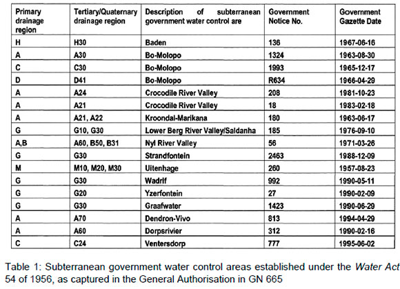
Although section 1 of the Water Act 54 of 1956 still distinguished between "private water" and "public water", and still regarded groundwater as "private water", this Act also gave the then Minister of Water Affairs the power to declare so-called subterranean government water control areas in which, in certain circumstances, the Minister could override private rights to use water.46 As a result, the use of groundwater that occurred in subterranean control areas became subject to statutory allocation rules. The water use right granted in these areas was a restricted right in involving prescribed quantities and purposes. In terms of the 1956 Act, the following subterranean government water control areas were subsequently declared:
Although the Water Act 54 of 1956 has since been repealed, some of its regulations retained legal standing under the National Water Act 36 of 1998 (NWA). Specifically, the subterranean government water control areas listed in Table 1 above are listed in the General Authorisations (GAs) promulgated under section 37 of the NWA47 for water uses as described under section 21(g) of the NWA, namely the disposal of waste in a manner that may detrimentally affect a water resource, where they are excluded from allowing such disposal under these GAs. This implies that these areas are regarded as too sensitive to allow the disposal of waste under a GA, and disposal of waste on these protected aquifers has to be authorised through the issuance of a water use licence (WUL).
3.2 Regulatory framework
Today the legal status of groundwater in South Africa is determined by a combination of the constitutional recognition of the right to access to water (section 27 of the Constitution of the Republic of South Africa, 1996)48 and the right to have the environment protected, including groundwater resources (section 24 of the Constitution), through reasonable legal and other measures, within the country's available resources.49
To achieve the progressive realisation of the constitutional water and environmental rights, a process was initiated in the year 1993 to review all of South Africa's water-related legislation.50 South Africa's water regulatory framework underwent a dramatic transformation with a new set of policies and legislation. A reformation of the water regulatory framework started in the mid-1990s and culminated in the NWA, which was specifically promulgated to "provide for fundamental reform of the law relating to water resources".51 A comprehensive analysis of each is beyond the scope of this paper, but the key policies and pieces of legislation include the White Paper on a National Water Policy for South Africa of 1997 (WPNWP), which contained 28 Fundamental Principles for Water Law Reform, the NWA, the White Paper on Water Supply and Sanitation Policy of 1994 (WSSP), the Water Services Act 108 of 1997, the National Environmental Management Act 107 of 1998 (NEMA), the National Water Resource Strategy of 2004 (NWRS) and the NWRS of 2013. To this list one also needs to add the Policy and Strategy for Groundwater Quality Management of 2000 and the National Groundwater Strategy of 2010.
The 28 Fundamental Policy Principles contained in the WPNWP set out the country's policy positions for the protection, use, development, conservation, management and control of South Africa's water resources. Of particular relevance to this discussion are:
• Principle 2: "All water, where-ever it occurs in the hydrological cycle, is a resource common to all, the use of which shall be subject to national control, and all water has a consistent status in law, irrespective of where it occurs";
• Principle 3: "There is no ownership of water, only a right to use water";
• Principle 4: "The location of water in relation to land doesn't confer preferential rights to use"; and
• Principle 18: "Since many land uses have a significant impact upon the water cycle, the regulation of land use shall, where appropriate, be used as an instrument to manage water resources within the broader integrated framework of land use management."
The WPNWP further stipulates inter alia that the "national government will act as custodian of the nation's water resources and its powers in this regard will be exercised as a public trust", that the "the government department or agency responsible for water resource protection must be able to influence land use planning decisions which could lead to unacceptable impacts on water resources", and that "provision has to be made for the licensing of land uses that substantially impact on the availability of water in an area" due to the fact that "water management cannot be separated from land use activities such as mining, human settlements, industrial activity, etc." The WPNWP further specifically acknowledges and provides for the regulation of groundwater. In fact, it stipulates that water resources cannot be managed in isolation; that water availability is governed by the water cycle; and that rain that falls may sink through the ground to be stored as groundwater in underground aquifers. The WSSP of 1994 also openly acknowledged the importance of groundwater and specifically articulated the need for increased knowledge about the characteristics of groundwater resources in South Africa. With the Policy and Strategy for Groundwater Quality Management of 2000 the Department of Water and Forestry identified approaches to provide the adequate protection and efficient management of groundwater quality. An important first step was to embark on a groundwater characterisation and mapping programme to identify utilisable groundwater resources. In addition, the National Groundwater Strategy of 2010 highlights the need for implementing protection zones around groundwater abstraction points. The Strategy also identifies the value and need for using groundwater vulnerability mapping in regulating groundwater resources. Such groundwater vulnerability maps, as well as maps indicating the utilisable exploitation potential of South Africa's groundwater resources, have already been produced.52
The NWA is the cornerstone of groundwater governance in South Africa,53by means of which these policy principles have been given legislative effect, and for this reason a critical assessment of the groundwater regulatory measures provided for in the NWA as well as the current level of implementation of these policy principles and measures is contained in the next paragraph.
3.3 The development and implementation of measures to regulate and protect South Africa's water resources
In terms of section 3 of the NWA the national government, as public trustee, is mandated to protect, use, develop, conserve, manage and control the country's water resources in an integrated manner.54 Section 1 of the NWA defines "water resources" to include "a water course, surface water, estuary, or aquifer". "Aquifer" is defined to mean "a geological formation which has structures or textures that hold water or permit appreciable water movement through them."55
Although some authors conclude that the NWA is rather vague about groundwater resources governance,56 this is not the case, as groundwater occurring in aquifers is implicitly part of the definition of water resource as indicated above. This misconception actually demonstrates the lack of understanding of the more complex processes that play a role in hydrogeology. Nevertheless, while the NWA has created equality in regulatory mechanisms for both surface and groundwater, this lack of understanding of groundwater is reflected in the mechanisms created for the implementation of the NWA, which often still have a bias towards surface water. Some of the deficiencies in these mechanisms in respect of groundwater regulation are discussed in the following paragraphs.
3.3.1 Control of water use through authorisation
The national government has overall responsibility for and authority over the country's water resources, including the equitable allocation and beneficial use thereof in the public interest. Chapter 4 of the NWA sets out the legal framework by which the national government is expected to publicly allocate and regulate the use of South Africa's water resources by means of a tiered authorisation system. Section 21 of the NWA describes several activities as "water uses" which require authorisation under Chapter 4 of the NWA. As it is not possible to regulate each individual activity that may potentially affect a water resource, only those activities that pose significant threats to the water resource and/or to other users of the water resource require regulatory intervention. Section 22 of the NWA, entitled "Permissible Water Use", therefore establishes a tiered authorisation system to optimise the regulation of water use. In accordance with subsection 22(1), a water use as described under section 21 must be authorised by means of a WUL, unless such water use is permissible under Schedule 1 of the NWA; or permissible as a continuation of an Existing Lawful Use (ELU);57 or permissible in terms of a GA issued under section 39 by Notice in the Government Gazette; or the Minister of the Department of Water and Sanitation (DWS) has dispensed with the requirement for a WUL (if the water use has been authorised in terms of another law that will address the requirements of the NWA), as provided for in subsection 22(3) of the NWA.
Sections 43 to 49 create a system of compulsory licensing of any aspect of water use in respect of one or more water resources in a specific geographic area and is intended to be used in areas which are or are soon likely to be under "water stress" (for example, where the demands for water are approaching or exceed the available supply, where water quality problems are imminent or already exist, or where the water resource quality is under threat), or where it is necessary to review the prevailing water use to achieve equity of the access to water. Compulsory licensing could therefore be declared for any activity overlying or potentially impacting a sensitive aquifer or an aquifer of particular socio-economic importance, for example.
The Tosca Molopo catchment, a portion of the Lower Vaal Catchment, is the only area in the country where the statutory measure of compulsory licensing was introduced for groundwater governance.58 The Tosca area was historically a stock farming area with cattle and game farming, but following the rapid development of irrigation in the 1990s,59 the socioeconomic and environmental profile of the area changed considerably. These changes resulted in the over-exploitation of groundwater. In 2003, compliance and enforcement actions were taken against various water users due to over abstraction, but as the water requirements for the Tosca catchment continue to exceed the amount available, the catchment was prioritised for compulsory licensing.60
The first published NWRS of 200461 stipulates that the national government, in allocating and regulating the country's water resources, should ensure that authorisation decisions are taken in the beneficial interest of all persons, and that such decisions must be constitutionally compliant. In addition, the government must ensure that the goals in relation to sustainability, equity and efficiency are met. The responsibility of the national government therefore includes the duty to manage and protect access to water resources for the intergenerational benefit of its citizens. Naturally, therefore, the notion of a tiered authorisation system should in theory help to ensure that activities that could have potential detrimental impacts on groundwater resources that are located in areas where sensitive aquifers with high socio-economic value occurs are well regulated and have adequate management measures in place to ensure that the risk of groundwater pollution is minimal.
It is regrettable to note that the existing WUL Application Regulations, published under sections 26 and 41 of the NWA62 do not require specific investigations for WUL applications for activities conducted on existing subterranean control areas.63 Moreover, the electronic WUL Application Assessment System (eWULAAS) does not even identify or mention aquifers as part of the water resource, although it is defined as such in the NWA.
Except for the GA under GN 655, that lists the subterranean government control areas, and the compulsory licensing for the Tosca area, the implementation of the authorisation mechanisms under the NWA are not currently adequately addressing the identification of sensitive aquifers or aquifers of significant socio-economic importance, and therefore the protection of these aquifers is currently ineffective and lacking.
3.3.2 Water resource protection mechanisms under Chapter 3 of the NWA
Chapter 3 of the NWA is entitled "Protection of Water Resources" and contains mechanisms to classify all water resources in order to designate their level of use, the setting of a Reserve for each significant water resource,64 and the establishment of resource quality objectives (RQOs),65which should set out the intended objectives to be achieved with the management of each significant water resource. As for the authorisation of water use, while the sections in the NWA are written for the water resource as a whole, the mechanisms developed for their implementation are biased towards surface water, as discussed in the next paragraphs.
3.3.2.1 The water resource classification system
Sections 12 to 15 of the NWA require the development of a classification system to determine different classes of water resources66 and specify in section 12(2)(b)(iii) that such a classification system must inter alia set out land-based activities which must be regulated or prohibited in order to protect the water resource. The classification system is thus used to direct the state or public trustee in the management of the country's water; and to protect the quality of such water.
A water resource classification system has been established under regulations made in terms of section 12(1) of the NWA,67 in terms of which water resources are grouped into classes representing different levels of protection.68 A Class I water resource is one that is minimally used, and in which the configuration of the ecological categories of the water resources in the catchment gives an overall condition of that water resource that is minimally altered from its pre-development condition.69 A Class II resource is one that is moderately used, and in which the configuration of ecological categories of the water resources in the catchment give an overall condition of that water resource that is moderately altered from its pre-development condition.70 In turn, a Class III water resource is one which is heavily used, and in which the configuration of ecological categories of the water resources in the catchment gives an overall condition of that water resource that is significantly altered from its pre-development condition.71
Inopportunely, however, the authors hereof posit that the classification system is surface water-biased72 in that it is based on the configuration of ecological categories which apply only to surface water resources and not to groundwater resources, and that it does not meet the requirements of section 12(2)(b)(iii) since it does not specify land-based activities which must be regulated or prohibited in order to protect the water resource. The absence of a regulatory classification system for groundwater resources based on their vulnerability or potential for exploitation or socio-economic importance should be flagged as a significant omission in the current mechanisms established for the classification of water resources. There is unfortunately no mechanism provided for in the NWA to amend the classification system as published, and unless there is an amendment to the NWA itself, the classification system will continue to be unsuited to the classification of groundwater resources to facilitate their protection.
3.3.2.2 The Reserve
Sections 16 to 18 of the NWA call for the establishment and implementation of the Reserve to enable the national government to manage and protect access to water resources, including aquifers. Part of the state's function is to make sure that the "water required to ensure that all people have access to sufficient water" and the "water necessary to maintain environmental sustainability" is reserved. The Reserve, as defined by chapter 1 of the NWA, read with the explanatory note of chapter 3 of the NWA, is the quantity and quality of water required to satisfy basic human needs and to protect aquatic ecosystems in order to secure ecologically sustainable development.73 It follows that the Reserve consists of two parts, namely the basic human needs reserve and the ecological reserve.74
The first part of the Reserve, the basic human needs reserve, imposes on the public trustee a duty to reserve such water required to ensure that all people have access to sufficient water inter alia for the purposes of drinking, food preparation and personal hygiene.75 Although challenged by a series of court cases,76 the basic human needs reserve was quantified by Regulation77 as 25 litres per person per day or 6 kilolitres per household per month within 200 metres from the household.78 The ecological reserve is more complex to determine, however. In fact, the accurate quantification of groundwater contributions to both parts of the Reserve is particularly challenging due to the widespread occurrence of fractured-rock aquifers, for example.79
Nevertheless, it is part of the fiduciary duty of the national government to assess the needs of the Reserve and to make sure that the determined amount of water required to meet such needs is set aside before any water is allocated to any productive use such as irrigation.80 Unfortunately none of the reserve determinations established or published to date has made provision of a "reserve" insofar as to protect the groundwater resources currently being used for domestic supply. It is also inopportune that no mechanism is provided for in the NWA to amend the reserve determinations as published. Unless there is an amendment to the NWA itself, the reserves that have been established will continue to be unsuited to the protection of groundwater resources.
3.3.2.3 Resource Quality Objectives (RQOs)
Sections 13 to 15 of the NWA also require the establishment of RQOs, which must be determined in accordance with their class, and must indicate the level of use of the resource that is deemed acceptable and is unlikely to damage a water resource beyond repair, so that the resource can be managed accordingly. The Classes and RQOs for a number of catchments have been promulgated. As discussed above, the Classes of resources were established based on a classification system that is biased towards surface water, and therefore all the subsequent published classes of water resources have failed to appropriately classify groundwater resources.
With regard to the RQOs that have been promulgated, these are also inadequate in properly setting management objectives for groundwater, although the definition for RQOs clearly indicates that it relates to the quality of all aspects of the water resource, including aquifers, and that it includes both the physical and chemical characteristics of the water resource. The only RQOs that were published to date that take cognisance of the scientific attributes of the quality of groundwater were the draft RQOs for groundwater resources for the Mokolo, Matlabas, Crocodile (West) and Marico catchments.81 Most of the RQOS that have been published specify that the quality of groundwater occurring naturally must comply with the SANS 241 Drinking Water Standard, which is both legally and scientifically flawed, as groundwater reflects the quality of the host rock within which it occurs and this is not always suitable for human consumption, and could sometimes even be harmful to humans, as it could contain naturally high levels of magnesium, sulphates, arsenic, selenium or uranium, for example.82
As with the classification system and the reserve determination, no mechanism is provided for in the NWA to amend the RQOs as published, and unless there is an amendment to the NWA itself the RQOs that have been published will continue to be unsuited to the protection of groundwater resources. Thus, although the NWA makes provision for the protection of groundwater resources, these provisions have not been translated into the mechanisms established for their implementation.
3.4 An assessment of South Africa S existing groundwater regulatory measures under the NWA
While the NWA provided an ideal opportunity for the judicious governance of South Africa's groundwater resources, the preceding discussion shows that the Act's implementation, when it comes to groundwater issues, remains rather weak.83 It may be argued on the basis of the above discussion that the mechanisms developed to implement South Africa's regulatory framework under the NWA do not always adequately provide for the governance and protection of groundwater, and are still biased towards surface water resources. The discussion has highlighted a number of implementation inadequacies especially in relation to the existing WULA Application Regulations, published under sections 26 and 41 of the NWA;84the Water Resource Classification System, the establishment of RQOs, and even the determination of the Reserve.85 The principles relating to groundwater as outlined in the WPNWP86 especially making use of land-use planning mechanisms to prevent the overexploitation and contamination of groundwater have therefore not been given proper consideration in the mechanisms developed for the implementation of the NWA.
The development and use of land are consistent elements in the list of potential threats to the quality of groundwater. It follows that, to protect South Africa's aquifers, the principles of environmental management and land-use management need to be revisited. Considering the need for the protection of vulnerable aquifers and aquifers that have significant socioeconomic importance against contamination arising from land-based activities and overexploitation in the light of the lack of sufficient legislative measures to facilitate such protection, the next paragraph explores the regulatory measures under legislation other than the NWA designed to protect the country's groundwater. This is necessitated by the fact that the principles of hydrogeology discussed above87 highlight the direct connection between land-based or anthropogenic activities and potential impacts on groundwater, and legislation other than the NWA governs certain land-uses.
4 Environmental and land-use management
4.1 National environmental management principles
The National Environmental Management Act 107 of 1998 (NEMA) was promulgated to provide a framework for co-operative environmental governance and aims to achieve this by establishing principles for state decision-making on matters that affect the environment.88 Section 1 (xi) of the NEMA defines the "environment" to include the surroundings within which humans exist and that are made of the land, water, atmosphere, plant or animal life, or any part or combination thereof. Section 2 of the NEMA sets out several environmental management principles. The importance of these principles has been recognised by the courts.89 They include that any land use development must be socially, environmentally, and economically sustainable; that government should promote public participation when making decisions about the environment;90 that decisions must be taken in an open and transparent manner;91 that the cost of remedying pollution, environmental degradation and negative impacts on health must be paid by those responsible for such pollution, degradation and health impacts (the "polluter pays" principle);92 that the environment is held in trust by the state for the benefit of all South Africans;93 and that a risk-averse and cautious approach should be followed when making decisions that could have environmental consequences.
These principles should guide the interpretation, administration and implementation of the NEMA and any other law concerned with the protection or management of the environment, which naturally includes any legislation that could have an effect on South Africa's aquifers,94 including the NWA, which has been declared a Specific Environmental Management Act (SEMA) under the NEMA95 and which is therefore similarly subject to the principles contained in section 2 of the NEMA.
4.2 Environmental authorisations
As part of the Act's attempt to protect the environment from undesirable impacts, environmental authorisations must be obtained for activities listed under section 24 of the NEMA, which requires that an Environmental Impact Assessment (EIA) be prepared in accordance with EIA Regulations.96
The purpose of the EIA process is to determine, assess and evaluate the consequences of a proposed development, activity, or project.97 Naturally the EIA process ought to be relevant when new anthropogenic activities in the vicinity of an aquifer are planned. The EIA must consider the strategic context of a development proposal along with societal needs, the natural resource base and the public interest. The EIA process should address ways to avoid negative impacts and enhance benefits. The EIA process includes a determination of whether an application for an environmental authorisation is required;98 and if so, whether the Basic Assessment Process or the scoping and EIA process must be undertaken. The listing notices as published identify activities on a different level of risk and identify certain activities in sensitive areas that require an EIA process, where undertaking such an activity in a less sensitive area does not require such a process, or requires the Basic Assessment instead of the full EIA process.
The National Department of Forestry, Fisheries and the Environment (DFFE) has developed a web-based screening tool99 that assists with the EIA-process, which geolocates the proposed activity in terms of possible sensitivities of the environment in which it is located in order to identify the type of assessment required, and the relevant specialist studies that may be required. The submission of a report generated by the screening tool in support of an application for an EIA has been compulsory since 2019,100and the DFFE now intends to adopt the screening tool as an Environmental Management Instrument.101 Although it identifies sensitive surface water resources, the screening tool does not address groundwater aspects at all, and that means that sensitive aquifers, as identified on the DWS's maps, or aquifers used for community water supply purposes, etc., are currently not considered as relevant when using this screening tool to determine the potential impacts of new developments. Adopting the Screening Tool as it currently stands as a National Environmental Management Instrument will thus not highlight the potential impact of development on aquifers.
It may therefore be held that the EIA process can help to ensure that activities that could have potential detrimental impacts on groundwater resources that are located in areas where sensitive aquifers with high socioeconomic value occur are well regulated and have adequate management measures in place to ensure that the risk of groundwater pollution is minimal.102 Unfortunately, the current Government Notices that include the listed activities of the EIA Regulations do not identify or list sensitive aquifers, and it will require an amendment of the existing Listing Notices to ensure that sensitive aquifers or aquifers with high socio-economic importance are properly addressed in the Listing Notices.
4.3 Planning law
Planning law generally comprises two distinct yet interrelated subdivisions, namely land management planning and land development management. These are instruments that are legislatively regulated by the Spatial Planning and Land Use Management Act 16 of 2013 (SPLUMA), and supported by the provinces' legislation. Land development planning takes place by means of integrated development plans, spatial development frameworks and land-use schemes. Land management planning, which is also known as land-use planning, is the creation of a blueprint for future land use that will support sustainable development. The underlying principle to this blueprint is "zoning".103 Zoning is used to allocate different land uses for different purposes while protecting inter alia the health, safety and welfare of the inhabitants of the area, as well as the character of the area itself.104
As it is the centrepiece of land-management planning, it is necessary to take a closer look at what zoning entails. Milton105 describes "zoning" as the creation of districts or areas in which different use activities are generally permitted or prohibited. It follows that zoning or land-use planning can in principle be used to minimise the potential of groundwater contamination by human activities that occur on or below the surface of the land. In spite of the specific policy statement in Principle 18 of the WPNWP, namely that the regulation of land use should be used as an instrument to manage water resources in the broader integrated framework of land-use management this has unfortunately not been incorporated into the land-use planning or zoning that has been undertaken in terms of the SPLUMA. However, as integrated development plans, spatial development frameworks and land-use schemes have to be reviewed once every five years, this creates the opportunity to incorporate measures for the protection of groundwater in sensitive aquifers or in aquifers with a high socio-economic value when these land-use planning instruments are being updated without the need to amend any existing legislation.
In fact, a number of countries including, for example, the United Kingdom (UK), Portugal, Germany and Australia have already developed and adopted planning law-related measures to protect groundwater resources against contamination from land-use activities,106 and some of these measures are discussed in the next paragraph.
5 Planning law and groundwater governance: Insights from foreign law
When some form of regulatory control is established over activities taking place on land which overlies vulnerable aquifers, the impact on both the quality and the quantity of the groundwater resource can be minimised. This section introduces the concept of a "groundwater or aquifer protection zone" as a control measure to prevent, minimise or control groundwater pollution from human activities taking place on land.107
5.1 The concept of a "groundwater protection zone"
As noted above, the concept of a zone of protection for areas containing groundwater has been developed in several countries.108 These countries have adopted, to varying degrees, a regulatory mechanism whereby they declare a certain area as a "groundwater protection zone". Once such a declaration has been made, constraints on certain land use activities are imposed.109 Notably, in the countries where the concept is implemented, protection zones are used in conjunction with existing regulatory tools such as environmental permitting and other pollution control legislation. These therefore serve as additional layers of control and offer specific protection for aquifers.
Groundwater protection zones are used to restrict or control activities that could detrimentally impact on groundwater resources.110 Commonly, in the legal systems of the countries mentioned above these restrictions are set through the use of legislation for land-use planning. The specific designation of the zone triggers relevant land-use restrictions or introduces additional permitting requirements. Once a protection zone or vulnerable area has been identified and designated, activities are defined which are either acceptable, unacceptable or need to be controlled by permitting in the protection zones.
5.2 Delineating groundwater protection zones
Examples from foreign law where groundwater protection zones are designated show that the number of groundwater protection zones varies between countries, but usually, two to four zones are delineated.111Generally, the first is the zone immediately adjacent to the site of the well or borehole. This zone (often referred to as the wellhead protection zone) is delineated to prevent the rapid ingress of contaminants or damage to the wellhead.112 The second zone (the inner protection zone) is delineated based on the time expected to be needed for a considerable reduction in pathogen presence to an acceptable level.113 Thirdly, the outer protection zone is defined based on the time needed for the dilution and effective attenuation of slowly degrading substances to an acceptable level.114 A fourth, much larger zone then covers the whole of the recharge area of a particular groundwater abstraction.115 The land-use constraints are increasingly stringent, moving from the outer protection zone to the wellhead (borehole) operational zone. In other words, the degree of land-use restriction reduces as the distance from the abstraction point increases.116
Existing scholarship provides an exposition of the typical land-use constraints for the respective protection zones:117 In the wellhead operation zone, all constraints of an inner protection zone and outer protection zone apply, plus land-use constraints such as some forms of agriculture (for example feedlots) and forms of traffic. In an inner protection zone, all constraints of an outer protection zone apply, in addition to land-use constraints such as waste disposal, mining and cemeteries. In the outer protection zone, constraints include wastewater and sewage treatment facilities, large informal settlements using pit latrines, and chemical plants or nuclear reactors. Naturally, choosing the appropriate protection zoning requires hydrogeological knowledge. Although this brief description of foreign practices may be elementary, aquifer protection zoning is a proactive step towards protecting the groundwater resources by the management of land use, recharge areas and potential contamination sources.
In the UK, for example, decisions on protection zones are taken squarely on the basis of hydrogeology, and more specifically, aspects of assessing the abstraction rate, specific yield, saturated thickness, the likely impact of a pollutant, and the degree to which attenuation occurs in the geological strata influencing the source.118 The national Policy and Practice for the Protection of Groundwater (National Rivers Authority, 1992), provides for three distinct source protection zones. Zone I, known as the Inner Source Protection Zone, is located immediately adjacent to the groundwater source, and is designed to protect against the effects of activities which would have an immediate outcome on the source. Zone I is defined as the area within which water would take 50 days to reach the abstraction point from any point below the water table, subject to a minimum of 50 m radius from the source. In turn Zone II, or the Outer Source Protection Zone, covers either the area corresponding to 400 days or the whole of the recharge area, calculated on the basis of 25 per cent of the long-term abstraction rate for the source. Zone III, known as the Source Catchment, covers the whole of the catchment area of the source, based on the area needed for long-term annual recharge to support the abstraction.
In Germany, comparable guidelines on the definition of zones are available through a Code of Practice.119 The sizes of the respective areas to be placed under protection are also dependent upon hydrogeological considerations, including the abstraction and recharge rates in the catchment area. The Code defines three zones.120 Zone I, the Well Field Protection Zone, is designed to protect individual wells and their immediate environment against any contamination and interference. Zone I has fixed dimensions of 10 m.121 Zone II, the Narrow Protection Zone, aims to provide protection against contamination by pathogenic bacteria and viruses and is based on a 50 day travel time.122 Due to the area of land required to meet the 50-day criterion it is not always possible to fix a boundary in karst terrains. Zone II may therefore vary in size, but should in any case comprise all areas from which a risk to a karst aquifer may emanate. Zone III, the Wide Protection Zone, serves to protect wells against long-range impairments, and usually covers the entire subsurface catchment area (recharge area).123 Chave et al124 argue that if the catchment area is larger, with a boundary more than 2 km from the well, it may be sub-divided into Zone III A and Zone III B, with different levels of land-use restrictions.
These foreign planning law initiatives could also be utilised in South Africa to enhance the protection of the country's groundwater that is vulnerable, sensitive, and/or of socio-economic importance.
The feasibility and beneficial use of harnessing science (hydrogeology) and planning law to protect South Africa's aquifers can be illustrated by a brief case study.
5.3 Feasibility of aquifer protection zones in South Africa125
Between 2015 and 2019 the City of Cape Town (CoCT) experienced its worst drought since 1904. Dam levels began declining in 2015, with the peak of the water shortage crisis occurring from mid-2017 to mid-2018, when water levels hovered between 15 and 30 per cent of total dam capacity, with some dam levels dropping as low as 11 per cent.126 As a result the CoCT explored alternative water resources, and one of the proposed alternatives entailed using the groundwater from the Cape Flats Aquifer and the Table Mountain Group Aquifer to augment bulk water supply for domestic use.127 The CoCT acknowledged the importance of the aquifers and understood the dire need to protect them. The CoCT then incorporated elements of land-use planning, but remarkably did so in addition to existing legislation by introducing "groundwater protection schemes" or "zones" under its spatial framework planning mechanisms.
In an effort to control activities in these zones the CoCT has merged them into the District Spatial Development Framework as well as the Municipal Spatial Development Framework. The zones are used as a management tool during spatial development assessments and are set to lead to rigorous land-use conditions or a decline in the authorisation of applications. Although potentially contaminating activities already exist in the delineated protection zones, the CoCT is committed to utilising these delineated zones for new applications for development, and also to assisting with monitoring and mitigation measures.128 Therefore, while the CoCT may still develop and enhance the beneficial use of its protection zones, their example is evidence of the fact that planning law may be well suited to ensuring the protection of South Africa's aquifers. In fact, land-use planning zones and regulations at aquifer level can be effective tools for groundwater resource conservation and quality protection, since they add scientific authority and clarity to decision-making processes. As shown in the CoCT, groundwater protection zones can readily be incorporated into local government land-use planning zones, with restrictions imposed to ensure acceptable land use. This paper postulates that this initiative should be formally included in the country's groundwater regulatory framework.
6 Concluding remarks
Groundwater is an integral part of the natural water cycle, and the primary water source for many cities, towns, and villages in South Africa. This paper has described the extreme vulnerability of South Africa's groundwater as well as some of the complexities associated with the science of hydrogeology. The paper has showed that a poor scientific understanding of groundwater systems not only leads to the groundwater resources being undervalued, but may render them subject to suboptimal legal protection. As a result, South Africa's aquifers remain vulnerable to contamination and over-exploitation.
Although South Africa's groundwater governance is elevated in the novel regulatory framework instated by the NWA and groundwater is no longer regarded as "private water", the mechanisms developed for the implementation of NWA still largely focus on surface water resources. In fact, existing subterranean government water control areas have not even been considered in the establishment of RQOs, and classification systems for aquifers have not been developed. Unfortunately, the systems that have been developed and implemented cannot be amended or reviewed, and such a review would require an amendment of the NWA itself. Consequently, South Africa's vulnerable aquifers remains compromised due to contamination and depletion because of anthropogenic activities.
A possible regulatory tool to address these insufficiencies would be the introduction of the concept of aquifer protection zoning. Based on principles of hydrogeology, this mechanism uses land-use planning mechanisms to protect sensitive or vulnerable aquifers that are of socio-economic importance. This link between land-use planning and groundwater protection has long been recognised in developed countries as protecting valuable groundwater resources.
Generally a delineated aquifer protection zone refers to the area of land that contributes to the delivery of groundwater at a specific borehole or wellfield. The delineation of a protection zone is the process of determining the area of land to include in such a zone, and the type of land-use activities that should be allowed or disallowed in the protection zone, taking cognisance of the local geology, and of whether pathways of transport or exposure exist for the contamination of groundwater to occur, or whether the potential for over-abstraction exists. The delineation could include the protection of the recharge zone. The implementation of such zoning would subject the respective zones to operational monitoring and would ensure that groundwater was effectively protected at the point of abstraction. Protection zone monitoring also includes checking whether the required restrictions in land use and human activities are being adhered to. Consequently, groundwater protection zones play a key component in the provision of water security for a given groundwater supply.
The delineation of groundwater protection zones has not yet been formally translated into control mechanisms in the broader South African regulatory framework, although it has been used for example in the CoCT. To ignore groundwater considerations in land-use decision making and land management would detrimentally affect both water and food security. Consequently, this article recommends, from a hydrogeological and planning-law perspective, that aquifer protection zoning should be formally introduced into the legislative framework aimed at protecting South Africa's aquifers. Declaring recharge areas especially as "groundwater protection zones" and limiting the type of anthropogenic activities that can take place in these areas would facilitate the protection of significant groundwater resources that support socio-economic activities such as domestic use and agricultural operations. These could be statutorily introduced through regulations under the SPLUMA,129 as well as an amendment of the EIA regulations to prevent development on identified aquifer protection zones. It is further recommended that policy documents and guidelines be drafted by geohydrologists and environmental law specialists to facilitate the establishment of these zones as a matter of priority, in order to ensure a water-secure future for South Africa.
Bibliography
Literature
Adams S et al "Critical Reflections on 20 Years of Groundwater Research, Development and Implementation in South Africa" 2015 South African Journal of Geology 5-16 [ Links ]
Adetunji VO and Odetokun IA "Groundwater Contamination in Agbowo Community, Ibadan Nigeria: Impact of Septic Tanks Distances to Wells" 2011 Malaysian Journal of Microbiology 159-166 [ Links ]
Akhtar N et al "Various Natural and Anthropogenic Factors Responsible for Water Quality Degradation: A Review" 2021 Water 1-35 [ Links ]
Bakalowicz M "Karst Groundwater: A Challenge for New Resources" 2005 Hydrogeology Journal 148-160 [ Links ]
Chave P et al "Groundwater Protection Zones" in Schmoll O et al (eds) Protecting Groundwater for Health (IWA London 2006) 465-492 [ Links ]
Cole MJ et al "Spatial Inequality in Water Access and Water Use in South Africa" 2018 Water Policy 37-52 [ Links ]
Department of Water Affairs Development of Reconciliation Strategies for All Towns in the Southern Planning Region: Provincial Summary Report -Western Cape (DWA Report No P RSA 000/00/15411) (Department of Water Affairs Pretoria 2011) [ Links ]
Department of Water Affairs National Groundwater Strategy (Department of Water Affairs Pretoria 2010) [ Links ]
Department of Water Affairs National Water Resource Strategy 2nd ed (Department of Water Affairs Pretoria 2013) [ Links ]
Department of Water Affairs and Forestry National Water Resource Strategy (Department of Water Affairs and Forestry Pretoria 2004) [ Links ]
Department of Water Affairs and Forestry Policy and Strategy for Groundwater Quality Management (Department of Water Affairs and Forestry Pretoria 2000) [ Links ]
Department of Water Affairs and Forestry White Paper on a National Water Policy for South Africa (Department of Water Affairs and Forestry Pretoria 1997) [ Links ]
Department of Water Affairs and Forestry White Paper on Water Supply and Sanitation Policy (Department of Water Affairs and Forestry Pretoria 1994) [ Links ]
Foose RM "Sinkhole Formation by Groundwater Withdrawal: Far West Rand, South Africa" 1967 Science 1045-1048 [ Links ]
Foster S et al Groundwater Quality Protection: A Guide for Water Utilities, Municipal Authorities and Environment Agencies (World Bank Washington DC 2002) [ Links ]
Jakeman AJ et al (eds) Integrated Groundwater Management: An Overview of Concepts and Challenges (Springer Cham 2016) [ Links ]
Knüppe K "The Challenges Facing Sustainable and Adaptive Groundwater Management in South Africa" 2011 Water SA 67-80 [ Links ]
Levy J and Xu Y "Review: Groundwater Management and Groundwater/Surface-Water Interaction in the Context of South African Water Policy" 2011 Hydrogeology Journal 205-226 [ Links ]
Ligavha-Mbelengwa L and Gomo M "Investigation of Factors Influencing Groundwater Quality in a Typical Karoo Aquifer in Beaufort West Town of South Africa" 2020 Environmental Earth Sciences 1-15 [ Links ]
Maclear LGA "The Hydrogeology of the Uitenhage Artesian Basin with Reference to the Table Mountain Group Aquifer" 2001 Water SA 499-506 [ Links ]
Milton J "Planning and Property" 1985 Acta Juridica 267-288 [ Links ]
Mutandanyi T Modelling Subsurface Water Flow in the Unsaturated Zone (MSc-thesis University of the Free State 2019) [ Links ]
Nel M Groundwater: The Myths, the Truths, and the Basics (WRC Report SP 108/17) (Water Research Commission Pretoria 2017) [ Links ]
Nel J et al "Benefit and Implementation of Groundwater Protection Zoning in South Africa" 2009 Water Resources Management 2895-2911 [ Links ]
Pienaar GJ and Van der Schyff E "The Reform of Water Rights in South Africa" 2007 Law, Environment and Development Journal 181-194 [ Links ]
Saayman IC et al Assessment of Aquifer Vulnerability in South Africa: Report to the Water Research Commission (WRC Report No 1432/01/07) (Water Research Commission Pretoria 2007) [ Links ]
Sami K and Druzynski AL Predicted Spatial Distribution of Naturally Occurring Arsenic, Selenium and Uranium in Groundwater in South Africa - Reconnaissance Survey (WRC Report 1236/1/03) (Water Research Commission Pretoria 2003) [ Links ]
Shiklomanov IA "World Fresh Water Resources" in Gleick P (ed) Water in Crisis (Oxford University Press Oxford 1993) 13-24 [ Links ]
Sun D and Zhan H "Flow to a Horizontal Well in an Aquitard-aquifer System" 2006 Journal of Hydrology 364-376 [ Links ]
Takacs D "South Africa and the Human Right to Water: Equity, Ecology, and the Public Trust Doctrine" 2016 Berkeley J Int'l L 55-108 [ Links ]
Tewari D "A Detailed Analysis of Evolution of Water Rights in South Africa: An Account of Three and a Half Centuries from 1652 AD to Present" 2009 Water SA 693-710 [ Links ]
Van Wyk J Planning Law 3rd ed (Juta Cape Town 2020) [ Links ]
Viljoen G "South Africa's Water Crisis: The Idea of Property as Both a Cause and Solution" 2017 LDD 177-200 [ Links ]
Viljoen G "Critical Perspectives on South Africa's Groundwater Law: Established Practice and the Novel Concept of Public Trusteeship" 2020 J Energy Nat Resources L 1-19 [ Links ]
Case law
City of Johannesburg v Mazibuko 2009 3 SA 592 (SCA)
Fuel Retailers Association of SA (Pty) Ltd v Director General, Environmental Management Mpumalanga 2007 2 SA 163 (SCA)
Hiscock v De Wet 1881 Buch AC 249
Hough v Van der Merwe 1874 4 Buch 148
Mazibuko v City of Johannesburg 2008 4 All SA 471 (W)
Mazibuko v City of Johannesburg 2010 3 BCLR 239 (CC)
Philippi Horticultural Area Food & Farming Campaign v MEC for Local Government, Environmental Affairs and Development Planning: Western Cape 2020 3 SA 486 (WCC)
Struben v Cape Town District Water Works Co 1892 9 SC 68
Legislation
Constitution of the Republic of South Africa, 1996
National Environmental Management Act 107 of 1998
National Environmental Management Laws Amendment Act 25 of 2014
National Water Act 36 of 1998
Spatial Planning and Land Use Management Act 16 of 2013
Water Act 54 of 1956
Water Services Act 108 of 1997
Government publications
Germany
DVGW Code of Practice W101 for Drinking Water Protection Areas Part 1, Protective Areas for Groundwater (1995)
South Africa
GN R509 in GG 22355 of 8 June 2001
GN 999 in GG 31417 of 19 September 2008
GN 708 in GG 33453 of 12 August 2010
GN 810 in GG 33541 of 17 September of 2010
GN 665 in GG 36820 of 6 September 2013
GN R982 in GG 38282 of 4 December 2014
GN R267 in GG 40713 of 24 March 2017
GN 40772 in GG 40772 of 7 April 2017
GN 1388 in GG 41310 of 8 December 2017
GN 960 in GG 42561 of 5 July 2019
GN 2464 in GG 46867 of 6 September 2022
United Kingdom
National Rivers Authority Policy and Practice for the Protection of Groundwater (1992)
Internet sources
City of Cape Town 2020 Our Shared Water Future: Cape Town's Water Strategy https://resource.capetown.gov.za/documentcentre/Documents/City%20strategies,%20plans%20and%20frameworks/Cape%20Town%20Water%20Strategy.pdf accessed 16 November 2022 [ Links ]
City of Cape Town Drought 2021 Information Portal https://www.capetowndrought.com/ accessed 31 October 2022 [ Links ]
Department of Water and Sanitation 2022 Tosca https://www.dws.gov.za/WAR/Tosca.aspx accessed 7 June 2022 [ Links ]
Department of Forestry, Fisheries and the Environment 2021 Screening Tool for EIA Processes https://screening.environment.gov.za/screeningtool/ accessed 15 September 2022 [ Links ]
Department of Water Affairs and Forestry 2005 Groundwater Resource Assessment II. Final Report https://www.dwa.gov.za/groundwater/GRAII.aspx accessed 20 June 2022 [ Links ]
Ellis J 2009 Sustainable Development and Precaution at the Interface between Science and Law https://papers.ssrn.com/sol3/papers.cfm?abstract_id=1504113 accessed 5 June 2022 [ Links ]
Environmental Agency 1997 Policy and Practice for the Protection of Groundwater: Thames Region Appendix http://ea-lit.freshwaterlife.org/archive/ealit:1144/OBJ/19000622.pdf accessed 15 January 2022 [ Links ]
Heath RC 1983 Basic Groundwater Hydrology: USGS Water Supply Paper 2220 https://pubs.usgs.gov/wsp/2220/report.pdf accessed 29 October 2022 [ Links ]
Rosewarne P, Woodford A and Girman J 2005 How Much Groundwater Does South Africa Have? SANCIAHS Conference, Midrand, September 2005 https://dxi97tvbmhbca.cloudfront.net/upload/user/image/1_A_Woodford20200304180745931.pdf accessed 15 June 2022 [ Links ]
USGS 2018 Where is Earth's Water? https://www.usgs.gov/special-topics/water-science-school/science/where-earths-water accessed 15 January 2022 [ Links ]
USGS 2019 How Much Water is There on Earth? https://www.usgs.gov/special-topics/water-science-school/science/how-much-water-there-earth accessed 7 June 2022 [ Links ]
List of Abbreviations
Berkeley J Int'l L Berkeley Journal of International Law
CoCT City of Cape Town
DFFE Department of Forestry, Fisheries and the Environment
DWA Department of Water Affairs
DWAF Department of Water Affairs and Forestry
DWS Department of Water and Sanitation
EIA Environmental Impact Assessment
ELU Existing Lawful Use
eWULAAS electronic Water Use License Application
Assessment System
GA General Authorisation
J Energy Nat Resources L Journal of Energy and Natural Resources Law
LDD Law, Democracy and Development
NEMA National Environmental Management Act 107 of 1998
NWA National Water Act 36 of 1998
NWRS National Water Resource Strategy
RQOs Resource Quality Objectives
SEMA Specific Environmental Management Act
SPLUMA Spatial Planning and Land Use Management Act 16 of 2013
UK United Kingdom
WPNWP White Paper on a National Water Policy for South Africa
WSSP White Paper on Water Supply and Sanitation Policy
WUL Water Use License
Date Submitted: 18 March 2022
Date Revised: 8 December 2022
Date Accepted: 8 December 2022
Date published: 14 December 2022
Editor: Prof AA du Plessis
Section Editor: Dr IL Owosuyi
* Germarié Viljoen. LLB LLM LLD (NWU). Associate Professor, Faculty of Law, North-West University, Potchefstroom Campus, South Africa. Email: Germarie.Viljoen@nwu.ac.za. ORCiD: https://orcid.org/0000-0003-2986-6572.
** Carin Bosman. BSc BSc (Hons)(Chem) MSc. Director, Carin Bosman Sustainable Solutions, South Africa. Email: carin@cbss.co.za.
† This work is based on the research supported by the National Research Foundation (NRF) of South Africa and the Dutch Research Council (De Nederlandse Organisatie voor Wetenschappelijk Onderzoek) Project UID 129352. Any opinion, finding, conclusion or recommendation expressed in this contribution is that of the authors.
1 Cole et al 2018 Water Policy 38.
2 Cole et al 2018 Water Policy 38; DWA National Water Resource Strategy 2013 (the NWRS 2013).
3 Nel et al 2009 Water Resources Management 2896.
4 Rosewarne, Woodford and Girman 2005 https://dxi97tvbmhbca.cloudfront.net/upload/user/image/1_A_Woodford20200304180745931.pdf 2.
5 Adams et al 2015 South African Journal of Geology 8; DWA Development of Reconciliation Strategies 844.
6 Adams et al 2015 South African Journal of Geology 8; while this article focusses on South Africa, the theme may be connected to broader, global considerations as 30 per cent of all fresh water on earth is found underground. USGS 2019 https://www.usgs.gov/special-topics/water-science-school/science/how-much-water-there-earth.
7 Adams et al 2015 South African Journal of Geology 7.
8 Forster et al Groundwater Quality Protection 2.
9 Nel Groundwater 7.
10 Although the use of groundwater for agricultural purposes has not yet been quantified in the same manner as for domestic use, scholars argue that the dependency on groundwater for agricultural purposes, including irrigation and stock watering, is even higher than the use for domestic purposes, which is significant from a food security perspective. It is also trite that other sectors, such as the mining industry, are also heavily dependent on groundwater for their operational supply. Adams et al 2015 South African Journal of Geology 7; Jakeman et al Integrated Groundwater Management 3.
11 Levy and Xu 2011 Hydrogeology Journal 211.
12 Ellis 2009 https://papers.ssrn.com/sol3/papers.cfm?abstract_id=15041131.
13 Jakeman et al Integrated Groundwater Management 4.
14 Nel Groundwater 10; USGS 2018 https://www.usgs.gov/special-topics/water-science-school/science/where-earths-water.
15 Some types of rocks are described as "aquitards", which are confining beds that retard the flow of water to or from an adjacent aquifer. Although an aquitard does not readily release water to streams, boreholes, or springs, it may also function as storage for groundwater. It is not regarded as an "aquifer" from either a scientific or a legal perspective, however. Sun and Zhan 2006 Journal of Hydrology 364.
16 Mutandanyi Modelling Subsurface Water Flow 1.
17 Mutandanyi Modelling Subsurface Water Flow 1 -3.
18 Foster et al Groundwater Quality Protection 4.
19 Nel Groundwater 12, 15; Saayman et al Assessment of Aquifer Vulnerability.
20 Mutandanyi Modelling Subsurface Water Flow 1 -3.
21 Notably, where the rate of exchange of water through the water cycle is about fourteen days for surface water (from falling as precipitation and entering a stream as surface runoff, until evaporating and falling as rain again), the exchange rate is much slower for water in aquifers (from falling as rain, filtering through the vadose zone, being discharged into a spring or stream, evaporating, and falling again as rain). Such an exchange can take millennia.
22 Nel Groundwater 9; Shiklomanov "World Fresh Water Resources" 15; Sun and Zhan 2006 Journal of Hydrology 364.
23 Heath 1983 https://pubs.usgs.gov/wsp/2220/report.pdf 1.
24 Akhtar et al 2021 Water 3.
25 Ligavha-Mbelengwa and Gomo 2020 Environmental Earth Sciences 1, 6.
26 Chemical oxidation and reduction processes caused by various factors can lead under reducing conditions to the dissolution of oxides and carbonates, the oxidation of sulphides and pyrites, and the denitrification of nitrogen forms. Under oxidising conditions, for example, when rock that was buried for millennia is exposed to the atmosphere, the reverse of these reactions can occur. This is typically measured with an oxidation-reduction potential meter.
27 Nel Groundwater 21.
28 Bakalowicz 2005 Hydrogeology Journal 149; Nel et al 2009 Water Resources Management 2901.
29 Fractured rock aquifers, for example, are found in hard rock environments. Groundwater is then stored in the fractures and cavities of the rock mass, but there is little to no decomposition of the rock that allows for groundwater movement. As a result, the storage of groundwater found in fractured aquifers is limited. Intergranular aquifers refers to aquifers in which groundwater flows in openings or void spaces between grains and weathered rock, while combined fractured and intergranular aquifers represent a multi-porous medium that consists of fractures and rock. These types of aquifers are particularly important to determine, for example, how aquifers would respond to the effects of resource degradation, and the possible pathways that pollutants can follow from a contamination source to a potential receptor. Nel et al 2009 Water Resources Management 2900-2901.
30 Adetunji and Odetokun 2011 Malaysian Journal of Microbiology 160.
31 Knüppe 2011 Water SA 69; Nel Groundwater 22.
32 Foose 1967 Science 1045.
33 Nel Groundwater 41.
34 Levy and Xu 2011 Hydrogeology Journal 211 ; Nel Groundwater 21.
35 Adams et al 2015 South African Journal of Geology 7.
36 In September 2005 a total of 3 000 people were diagnosed with diarrhoea and 561 with typhoid fever. Five deaths were officially recorded. Adams et al 2015 South African Journal of Geology 12; Nel et al 2009 Water Resources Management 2899
37 Shiklomanov "World Fresh Water Resources" 23.
38 Pienaar and Van der Schyff 2007 Law, Environment and Development Journal 181.
39 Tewari 2009 Water SA 693.
40 Tewari 2009 Water SA 695.
41 Hough v Van der Merwe 1874 4 Buch 148.
42 Hough v Van der Merwe 1874 4 Buch 148.
43 Struben v Cape Town District Water Works Co 1892 9 SC 68.
44 Hiscock v De Wet 1881 Buch AC 249; Knüppe 2011 Water SA 70.
45 Maclear 2001 Water SA 499.
46 Section 28 of the Water Act 54 of 1956.
47 Schedule 3 of GN 665 in GG 36820 of 6 September 2013.
48 Viljoen 2020 J Energy Nat Resources L 10.
49 Due to the scope of this article, the content and meaning of ss 24 and 27(1)(b) of the Constitution of the Republic of South Africa, 1996 (the Constitution), as well as the obligations of the state in terms of the constitutional water and environmental rights, will not be discussed in detail.
50 Knüppe 2011 Water SA 70.
51 Long title of the National Water Act 36 of 1998 (NWA).
52 DWAF 2005 https://www.dwa.gov.za/groundwater/GRAII.aspx.
53 Knüppe 2011 Water SA 70; Viljoen 2020 J Energy Nat Resources L 10.
54 Adams et al 2015 South African Journal of Geology 7; Viljoen 2020 J Energy Nat Resources L 13
55 These definitions imply that not all groundwater (water occurring underground) is regarded as part of the water resource, as water in the vadose zone, for example, is excluded.
56 Viljoen 2020 J Energy Nat Resources L 3.
57 Section 32 of the NWA defines an ELU as any water use which has lawfully taken place in the two years preceding the commencement of the NWA, namely, between 1 October 1996 and 30 September 1998. In accordance with section 34 of the NWA, a person, or that person's successor-in-title, may continue with an ELU, subject to any existing conditions or obligations attaching to that use; its replacement by a WUL in terms of the NWA; or any other limitation or prohibition by or under the NWA.
58 DWS 2022 https://www.dws.gov.za/WAR/Tosca.aspx.
59 DWS 2022 https://www.dws.gov.za/WAR/Tosca.aspx.
60 GN 708 in GG 33453 of 12 August 2010.
61 DWAF National Water Resource Strategy 2004 (the NWRS 2004) A 1, Principle 13; GN 708 in GG 33453 of 12 August 2010.
62 GN R267 in GG 40713 of 24 March 2017.
63 This is regrettable as these are already identified as sensitive groundwater resources.
64 "Reserve" is defined in section 1 of the NWA to mean "the quantity and quality of water required - (a) to satisfy basic human needs by securing a basic water supply, as prescribed under the Water Services Act 108 of 1997, for people who are now or who will, in the reasonably near future, be - (i) relying upon; (ii) taking water from; or (iii) being supplied from, the relevant water resource; and (b) to protect aquatic ecosystems in order to secure ecologically sustainable development and use of the relevant water resource."
65 "Resource quality" is defined in section 1 of the NWA to mean "the quality of all the aspects of a water resource, including the quantity, pattern, timing, water level and assurance of instream flow; the water quality, including the physical, chemical and biological characteristics of the water; the character and condition of the instream and riparian habitat; and the characteristics, condition and distribution of the aquatic biota."
66 See GN 999 in GG 31417 of 19 September 2008.
67 GN 810 in GG 33541 of 17 September 2010.
68 See Levy and Xu 2011 Hydrogeology Journal 210
69 See Reg 2(3)(a) in GN 810 in GG 33541 of 17 September 2010.
70 See Reg 2(3)(b) in GN 810 in GG 33541 of 17 September 2010.
71 See Reg 2(3)(c) in GN 810 in GG 33541 of 17 September 2010.
72 See GN 810 in GG 33541 of 17 September 2010.
73 Viljoen 2017 LDD 191-194.
74 Knüppe 2011 Water SA 70.
75 Takacs 2016 Berkeley J Int'l L 80.
76 Mazibuko v City of Johannesburg 2008 4 All SA 471 (W); City of Johannesburg v Mazibuko 2009 3 SA 592 (SCA); Mazibuko v City of Johannesburg 2010 3 BCLR 239 (CC).
77 GN R509 in GG 22355 of 8 June 2001.
78 Levy and Xu 2011 Hydrogeology Journal 210
79 Levy and Xu 2011 Hydrogeology Journal 206.
80 Any other use would include basic human needs and the needs of the ecological reserve. Knüppe 2011 Water SA 70.
81 GN 1388 in GG 41310 of 8 December 2017.
82 Sami and Druzynski Predicted Spatial Distribution 2-6.
83 Knüppe 2011 Water SA 70; Viljoen 2020 J Energy Nat Resources L 3.
84 See section 3.3.1 above.
85 See section 3.3.2 above.
86 See section 3.2 above.
87 See section 2 above.
88 Long title of the National Environmental Management Act 107 of 1998 (the NEMA).
89 See, for example, the case of Fuel Retailers Association of SA (Pty) Ltd v Director General, Environmental Management Mpumalanga 2007 2 SA 163 (SCA) that was decided on NEMA principles.
90 Section 2(4)(f) of the NEMA.
91 Section 2(4)(k) of the NEMA.
92 Section 2(4)(p) of the NEMA.
93 Section 2(4)(o) of the NEMA.
94 Section 2(1)(e) of the NEMA.
95 The NWA was declared as a SEMA under the National Environmental Management Laws Amendment Act 25 of 2014.
96 GN 40772 in GG 40772 of 7 April 2017.
97 Regulation 2 in GN R982 in GG 38282 of 4 December 2014.
98 Any activity that is listed in Listing Notice 1, Listing Notice 2 and Listing Notice 3 of the Environmental Impact Assessment (EIA) Regulations is subject to environmental authorisation. The difference between the Listing Notices is in the process that needs to be followed. Listing Notice 1 activities are subject to Basic Assessment and those in Listing Notice 2 to Scoping and Impact Assessment. For ease of reference, the term EIA is used when information is relevant to both these processes.
99 DFFE 2021 https://screening.environment.gov.za/screeningtool/.
100 GN 960 in GG 42561 of 5 July 2019.
101 GN 2464 in GG 46867 of 6 September 2022.
102 As confirmed by Philippi Horticultural Area Food & Farming Campaign v MEC for Local Government, Environmental Affairs and Development Planning: Western Cape 2020 3 SA 486 (WCC).
103 Van Wyk Planning Law 222.
104 Van Wyk Planning Law 222.
105 Milton 1985 Acta Juridica 267-288.
106 Chave et al "Groundwater Protection Zones" 472-476.
107 Chave et al "Groundwater Protection Zones" 466.
108 Chave et al "Groundwater Protection Zones" 472-476; Nel et al 2009 Water Resources Management 2896.
109 Chave et al "Groundwater Protection Zones" 466.
110 Nel et al 2009 Water Resources Management 2896.
111 Chave et al "Groundwater Protection Zones" 467; DVGW Code of Practice W101 for Drinking Water Protection Areas Part 1, Protective Areas for Groundwater (1995); National Rivers Authority Policy and Practice for the Protection of Groundwater (1992).
112 Chave et al "Groundwater Protection Zones" 466; DVGW Code of Practice W101 for Drinking Water Protection Areas Part 1, Protective Areas for Groundwater (1995); Foster et al Groundwater Quality Protection 34; National Rivers Authority Policy and Practice for the Protection of Groundwater (1992).
113 Chave et al "Groundwater Protection Zones" 467; Nel et al 2009 Water Resources Management 2902, 2903.
114 Chave et al "Groundwater Protection Zones" 467; Nel et al 2009 Water Resources Management 2903.
115 Chave et al "Groundwater Protection Zones" 467; Nel et al 2009 Water Resources Management 2903.
116 Nel et al 2009 Water Resources Management 2903.
117 Chave et al "Groundwater Protection Zones" 486; Nel et al 2009 Water Resources Management 2904; Foster et al Groundwater Quality Protection 38.
118 Environmental Agency 1997 http://ea-lit.freshwaterlife.org/archive/ealit:1144/OBJ/19000622.pdf 9.
119 Chave et al "Groundwater Protection Zones" 486.
120 Chave et al "Groundwater Protection Zones" 485.
121 Chave et al "Groundwater Protection Zones" 474.
122 Chave et al "Groundwater Protection Zones" 474.
123 Chave et al "Groundwater Protection Zones" 474.
124 Chave et al "Groundwater Protection Zones" 474.
125 See also Nel et al 2009 Water Resources Management 2906.
126 City of Cape Town Drought 2021 https://www.capetowndrought.com/.
127 CoCT 2020 https://resource.capetown.gov.za/documentcentre/Documents/City%20strategies,%20plans%20and%20frameworks/Cape%20Town%20Water%20Strategy.pdf 35-37.
128 Nel et al 2009 Water Resources Management 2905.
129 Both Acts already contain the appropriate mechanisms to make such regulations.

