


Servicios Personalizados
Articulo
 Inglés (pdf)
 Articulo en XML
 Referencias del artículo
Indicadores

Links relacionados
-
 Citado por Google
 -
 Similares en Google
Compartir

 Permalink
Journal of the South African Institution of Civil Engineering
versión On-line ISSN 2309-8775
versión impresa ISSN 1021-2019
J. S. Afr. Inst. Civ. Eng. vol.65 no.4 Midrand dic. 2023
http://dx.doi.org/10.17159/2309-8775/2023/v65n4a1
TECHNICAL PAPER
Mapping SCS hydrological soil groups over South Africa at terrain unit spatial resolution
R E Schulze; S Schütte
ABSTRACT
Given the many users in South Africa of the SCS (Soil Conservation Service) hydrograph-generating technique, which requires key soils information, this paper presents a methodology to develop a detailed map (at the spatial resolution of South Africa's 27 491 terrain units) of the SCS runoff-related soil groups. In order to achieve this objective, background is first provided on the soils context within the SCS technique, as well as on the approaches to defining SCS hydrological soil groups, by assigning SCS soil groups to South African soil series. Steps when mapping SCS soil groups across South Africa at terrain unit spatial resolution are then outlined. This is followed by the presentation and interpretation of the detailed terrain unit level map of SCS soil groups for South Africa. The detailed new map illustrates the finer detail across contributing catchments countrywide now obtained from the terrain unit approach, compared to the previous map of SCS soil groups based only on the coarser soil land types.
Keywords: SCS model, hydrological soil groups, soils terrain units, mapping, hydrograph-generating technique, terrain-unit approach
THE SCS HYDROGRAPH-GENERATING TECHNIQUE, ITS BACKGROUND, THE SOUTH AFRICAN CONTEXT, AND OBJECTIVES OF THE PAPER
There is a frequent need for hydrological information in the planning and design of water-related structures such as culverts, stormwater systems or spillways on small catchments, i.e. with areas < 30 km2. Runoff volumes and peak discharge rates are commonly required for selected design return periods, and in the absence of long-term measurements at the locations where such structures are required, these have to be estimated by simulation modelling. Such simulation models inherently account for rainfall, land use and catchment hydraulic characteristics, but the importance of soil characteristics is often underestimated. The reason for this is a lack of appreciation that it is the soil that absorbs, retains and releases water following a rainfall event, and that soil is thus a prime regulator of the catchment's response to rainfall.
One rainfall-runoff model which has become accepted and established worldwide, also in South Africa (SA), for use on small catchments is the USDA's (United States Department of Agriculture) Soil Conservation Service (SCS) technique for the estimation of design flood volume and peak discharge (USDA 1972 and updates).
For Southern African applications of the SCS, methods were first developed by Reich (1962), followed by Schulze and Arnold (1979), and Schmidt and Schulze (1984; 1987a, b), with links to the daily time-step ACRU model (Schulze 1984) and additional updated soils information for SA (Schulze et al 1992; 2004; Schulze 2012). Since 1992, this specific South African approach has been called SCS-SA.
Previous soil-related mapping across SA for use with the SCS technique was based on the hydrological characteristics of so-called soil land types, of which just over 6 000 had been mapped for the country (Schulze 2012). This spatial resolution is, however, relatively coarse when used across small catchments, for which the SCS technique had been designed.
The objective of this paper is to present a methodology by which a finer detailed map of SCS soil-related information for SA has been developed at the spatial resolution of "soils terrain units" (TUs), of which over 27 000 were identified across the country. The reason for the detailed mapping is that many users of the SCS in SA may not have the time, nor the background, to undertake the necessary soils fieldwork when applying the SCS-SA model for small catchments. The detailed SCS soils mapping outlined below is anticipated to reduce errors in simulated runoff volumes and peak discharges, compared with the coarser soils information previously available.
In order to achieve the above objective, the following aspects are discussed:
■ The soils context within the SCS hydrograph generating technique
■ The original approach to defining SCS hydrological soil groups, with emphasis on the approach adopted in SA
■ Steps when mapping SCS soil groups across SA at TU resolution.
Thereafter the outcomes of the study are presented in the form of maps of SCS soil groups across SA at terrain unit spatial resolution, an interpretation of the maps, and a section on applications, followed by some concluding thoughts.
THE SOILS CONTEXT IN THE SCS HYDROGRAPH-GENERATING TECHNIQUE
In the SCS hydrograph-generating technique (USDA 1972), runoff depth is expressed as:
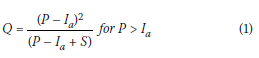
Where:
Q = runoff depth (mm equivalent)
P = daily rainfall depth (mm)
S = potential maximum soil water retention (mm), an index of the catch-ment's soil wetness prior to a rainfall event
Ia = initial losses (abstractions) prior to the commencement of runoff.
Crucial to this paper from Equation 1 is the potential maximum soil water retention S, because it includes the catch-ment's soil moisture status just prior to a rainfall event, with S related, inter alia, to hydrological soil properties, categorised into seven hydrological soil groups. S finds expression through a dimensionless runoff response index termed the catchment's curve number (CN), which is related to S by:
Before any adjustments for a catchment's wetness condition just prior to a runoff-producing rainfall event are made, an initial CN is determined according to soils and land-cover properties. These initial CNs have values given in SCS literature for a wide range of land cover and treatment classes, and hydrological soil groups. Important in the context of this paper is that the initial curve numbers, and hence S in the runoff equation (Equation 1), vary by hydrological soil groups, which for South African conditions have been categorised into seven groups (see later).
DEFINING SCS HYDROLOGICAL SOIL GROUPS
Soils in South Africa were assigned to the seven hydrological soil groups based on texture, compaction (bulk density) and strength of soil structure (Schulze 1995) for use in the estimation of soil water movement, which is controlled by its infiltration rate at the surface and its permeability. The seven hydrological soil groups are termed as follows:
■ A: Low Runoff Potential when thoroughly wet, typically with low clay content, high infiltration rates, and being well drained
■ B: Moderately Low Runoff Potential when thoroughly wet
■ C: Moderately High Runoff Potential when thoroughly wet
■ D: High Runoff Potential when thoroughly wet, typically with high clay content, low infiltration rates, and being poorly drained
■ Transitional subgroups A/B, B/C and C/D. More details on the above can be found in USDA (1972) and Schulze (1995).
ASSIGNING SCS SOIL GROUPS TO SOUTH AFRICAN SOIL SERIES
During the course of the development of the first South African SCS User Manual (Schulze & Arnold 1979), and in subsequent research on runoff responses to soils properties (e.g. Schulze et al 1985), an expert group of soil and hydrological scientists classified the country's 501 soil series into SCS soil groups (A, A/B, ... D). This was done using the South African Binomial Soil Classification (MacVicar et al 1977) on the basis of soil texture, leaching, crusting, water table height and clay distribution models, which are related to clay properties with soil depth.
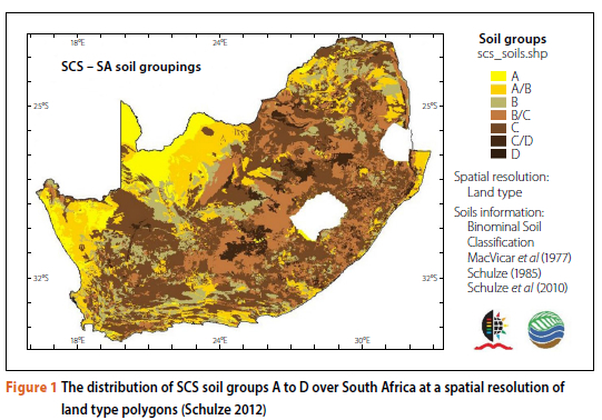
While a soil land type is defined as "a homogeneous, unique combination of terrain type, soil pattern and macroclimate zone" (SIRI 1987), based primarily on agricultural rather than hydrological properties, the polygons of these land types, of which there are over 6 000 across SA, then determined the spatial resolution at which SCS soil groups across SA were mapped (Schulze 2012). See Figure 1.
With soil classifications in SA continually evolving, this study, however, retained the SCS soil groupings according to the SA Binomial Classification by MacVicar et al (1977), rather than soil groupings from more recent South African soils classifications, e.g. the Taxonomic Classification (SCWG 1991). The reason for this is that the Binomial Classification is the classification at which soils of SA were spatially defined. An attempt to match soil properties between the two classifications can be found in Schulze and Schütte (2020).
STEPS WHEN MAPPING SOIL GROUPS FOR THE SCS-SA APPROACH ACROSS SOUTH AFRICA AT TERRAIN UNIT SPATIAL RESOLUTION
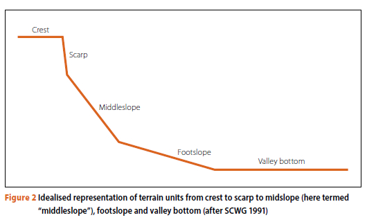
As defined in SIRI (1987), a terrain unit (TU) is a subdivision of land types with homogeneous slope and form, e.g. a convex or a concave slope, or a near-vertical cliff. Terrain can be thought of as being made up of all, or some, of the following kinds of TUs: a crest, scarp, midslope, footslope, and the valley bottom, as shown in an idealised representation in Figure 2. Each of these TUs will likely have different hydro-logical soil properties, and hence different runoff and peak discharge responses, which will be better reflected in the TU-based SCS-SA classes than in the coarser land-type-based classes. More detailed information on the TUs is given later.
Assigning an SCS soil group to each of the 501 Binomial Classification soil series identified in SA (Schulze 1985) proved only a first step towards mapping the SCS soil groups at the TU spatial resolution. The steps which needed to be taken in order to map SCS soil groups per TU were as follows:
■ The first was to use the detailed soil inventories for each land type to isolate and define properties of the TUs making up each land type.
■ The second step was to describe the methodology of delineating land types into TUs by digital elevation modelling.
■ The third step was to outline the method of weighting each soil series within a TU for subsequent mapping purposes.
These steps set the scene for presenting a series of maps of SCS soil groups across SA at the spatial resolution of TUs.
Step 1: From inventories of information associated with each soil's land type to terrain unit information
The (now digitally) delineated and mapped 6 000+ soil land types are accompanied by detailed tabulated inventories of information on each land type which were compiled using data collected during the terrain, soil and climate survey phases (Land Type Survey Staff undated). Each land type is made up of a number of soil series, with the inventory of each land type containing information regarding, inter alia:
■ the percentage, by area, of the individual soil series making up that land type and of relevance to this study on SCS soil grouping
■ information on the soil physical properties of each soil series within a land type, such as clay content, soil texture class, soil profile thickness and soil depth limiting material.
More importantly, in the inventory of each of the 6 000+ land types there is information on the soil series which are found in up to 5 TU classes making up a land type (see Figure 2). These TUs, which had been identified in the field and were named in the section above, are the crest (defined as being convex-shaped), the scarp (akin to a cliff), the midslope (concave in shape), the footslope (also concave in shape) and the valley bottom (also known as the wet area adjacent to a stream).
For each TU making up a land type soils mapping unit:
■ the individual areas of the TUs are given, as are
■ the specific soil series making up each TU, together with
■ the respective areas of each soil series within the specific TU of the land type.
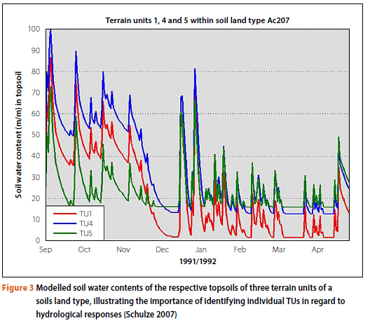
Because each TU within a land type comprises different (but usually related) individual soil series, each with different soil thicknesses and hydrological properties, it stands to reason that each TU would have a different hydrological response. This is illustrated in Figure 3 in which the different soil water contents of the topsoil of the crest (TU 1), of the footslope (TU 4) and the topsoil of the valley bottom (TU 5) of land type Ac207, all modelled by the ACRU daily time-step and process-based model (Schulze 1995 and updates), are shown for an identical climate time series.
Step 2: Delineation of terrain units within soils land types
While still at the Agricultural Research Council (ARC), Hein Beukes (Beukes 2018, personal communication) superimposed a Digital Elevation Model (DEM) with a 90 m resolution (pixel) over each mapped soils land type identified in SA, and then used Neighbourhood Analysis to compute the slope to the north, east, south and west pixel from the pixel of interest in order to determine convexity or concavity to the neighbouring pixels. On the premise that the crest was convex-shaped, but that the midslope was concave in shape, he then applied zonal statistics to delineate and then map the individual TUs within a land type. Following that procedure, he then superimposed satellite imagery at a 30 m resolution over the map of TUs to refine the delineations of the TUs, especially the valley bottoms in hilly areas. This was because the 90 m resolution of the DEM, while being at a satisfactory spatial resolution in flattish terrain, was found to be too coarse where it was hilly. From Beukes' ARC Database of Terrain Units per Soils Land Type, based on the refined 90 m DEM, 27 491 spatially defined TUs were identified across SA by the techniques described above.
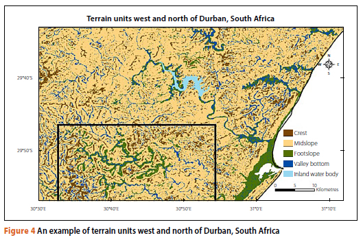
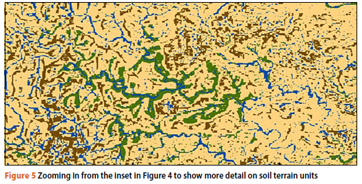
To illustrate the spatial detail from mapping SA's soils at the TU level, an area to the north and west of Durban in KwaZulu-Natal was selected (Figure 4). The figure shows the delineated crests in dark brown, midslopes in light brown, footslopes in green and the valley bottoms in dark blue (Figure 4). Scarps, taken to be vertical to near-vertical, are assumed to have no spatial extent when mapped. When the rectangular inset in Figure 4 is zoomed in upon in Figure 5, the degree of detail of the TU delineations is even more evident, with individual pixels of a specific TU visible in places. It is at this level of spatial detail that the SCS soil groups were mapped.
Step 3: Weighting each soil series within a terrain unit for mapping purposes
Each TU can have multiple soil series. However, a typical representative SCS-SA soil group had to be established per TU. This was achieved by first assigning a weighting to each of the seven SCS-SA soil groups, as in the left column of Table 1, with A soils assigned an arbitrary weighting of 1 through to D soils with an arbitrary weighting of 7, with a range of aggregate weighting shown in the right column of the table.
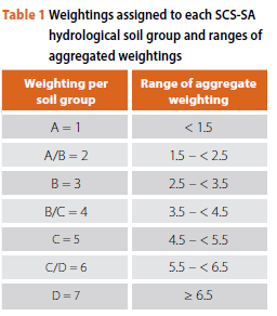
The area-weighted SCS-SA soil group for a TU was then established, as in the example given in Table 2, in which in the top table (2a) land types Ia155, Fb143 and Db218 (column 1) each have one or more TUs (column 2) covering a certain percentage of the land type (%TU, last column). Each of the TUs represents two or more of the crest (CR), the midslope (MS), footslope (FS) and/or the valley bottom (VB), and with each TU made up of between 3 and 8 soil series (SS 1 to SS 8), with each soil series covering a percentage of that TU (%SS1 to %SS8). In the middle table (2b) the individual names of the soil series of a TU are replaced by their respective SCS soil groups (i.e. A; A/B; ... D) in columns SCS1 to SCS8. In the bottom table (2c) the SCS soil group symbols are replaced by their respective weightings from Table 1 (left column), and the individual percentages of each soil series in a TU (%SS1 to %SS8) are replaced by an area-weighted fraction (Fr SS1 to Fr SS8), which is computed by multiplying the percentage of a soil series (e.g. 50% or 0.5 for the first soil series) by its weighting (namely 6) to give a fraction of 3.0. The sum of the fractions is given in the TOTAL column of Table 2c, where for the first row a TOTAL = 5.25 would then be assigned to being a C group soil (the SCS equivalent column of Table 2c) when that TU is mapped (aggregate weighting between 4.5 and 5.5 in the right column of Table 1), while the second row's TU would be mapped as a B soil (TOTAL = 3.1, between 2.5 and 3.5 in Table 2). Note that R in Table 2 represents rocks.
The steps outlined above were applied to all 27 491 TUs covering SA to enable the SCS soil groups to be mapped at TU spatial resolution.
THE OUTCOME: MAPS OF SCS-SA SOIL GROUPS ACROSS SOUTH AFRICA AT TERRAIN UNIT SPATIAL RESOLUTION
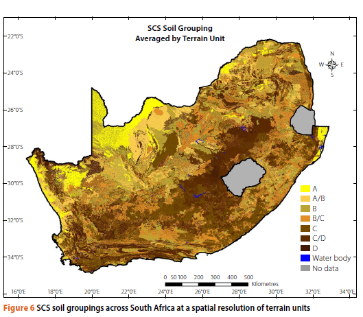
In Figure 6 it is shown, firstly, that considerably greater spatial detail of SCS-SA soil groups at TU resolution is evident than in the previous mapping at land type resolution (Figure 2). Secondly, it is shown that the SCS-SA soil groups cover the entire spectrum from low-runoff-producing A soils in the desert areas of the northwest of SA and the coastal plains in the extreme east of the country, to the high-runoff-producing C/D and D soils found throughout SA.
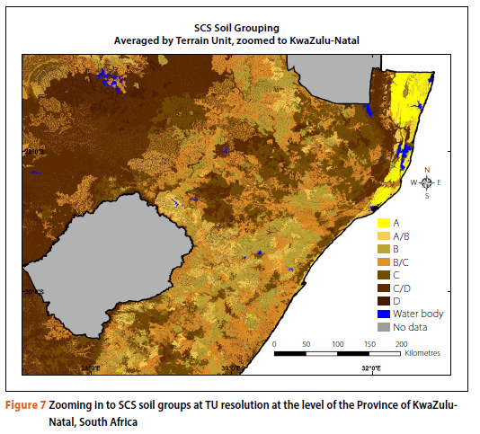
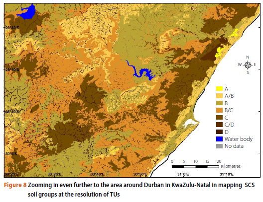
When zooming in, say to the scale of a province, Figure 7 shows greater spatial detail than can be seen at national level, with in places A and D soils in adjacent TUs being illustrated within KwaZulu-Natal. Zooming in even further to an area around Durban in KwaZulu-Natal, Figure 8 displays even more spatial detail of the runoff potential of soils, with the often-high runoff and frequently waterlogged soils of valley bottoms adjacent to streams visible upon close inspection.
IMPROVEMENTS IN HYDROLOGICAL MODELLING WHEN USING SOIL INFORMATION AT TERRAIN UNIT RESOLUTION
The higher resolution of hydrological soil classes at TU level, compared to the lower resolution from land types, has been shown by others working on a small number of instrumented catchments in KwaZulu-Natal to give a markedly better fit of SCS-derived flood peak discharge and runoff depth, when modelled results are compared against runoff observations (e.g. Rowe 2019; Loots & Smithers 2020; Maharaj 2021). While a detailed field determination of hydrological soils responses invariably remains the best option for modelling, in cases where only a desktop assessment is possible because of time, financial or expertise constraints, the TU methodology has major advantages over using the much coarser land-type soils determination.
CONCLUSIONS
In catchment hydrological design, when using SCS-derived hydrograph techniques, runoff and peak discharges are highly sensitive to input variables such as soil hydrological properties. For design engineers and hydrologists in SA, obtaining accurate SCS-related soils information is often a stumbling block, as detailed soil maps usually have an agricultural basis. Soils fieldwork, if the relevant expertise exists, is both time-consuming and expensive.
As background, this paper presented the soils context within the SCS hydrograph-generating technique, the original approach to defining SCS hydrological soil groups, the approach adopted in SA to assigning SCS soil groups to soil series, and a sensitivity study of hydrological responses in the SCS technique to soils input. This background provided a framework for then outlining the various steps when mapping SCS soil groups across SA at TU spatial resolution. The outcomes of the study are detailed maps of SCS soil groups across SA at TU spatial resolution, a spatial resolution not previously attempted, and an interpretation of the maps. These maps are seen as a valuable new tool for the country's design engineers and hydrologists, in many instances saving time and money on soils-related fieldwork.
The dataset is available as GIS-compatible SCS soils group spatial information at TU resolution, and can be downloaded from the following site: https://data.waterresearchobservatory.org/metadata-form/scs-hydrological-soil-groups-over-south-africa-at-terrain-unit-resolution.
ACKNOWLEDGEMENTS
We wish to acknowledge Hein Beukes, retired from the Agricultural Research Council of South Africa, for having developed the Terrain Unit Database for South Africa, and for having made it accessible to this study. We also thank the Water Research Commission of South Africa for funding this research under Project C2019-2020-00205 Development of Datasets for Multi-Scale Water Resource Assessments Towards a Water Secure South Africa.
REFERENCES
Beukes H 2018 (retired from the Agricultural Research Council). Personal communication. [ Links ]
Land Type Survey Staff n.d. 1:250 000 Scale land type survey of South Africa. Pretoria: Agricultural Research Council, Institute for Soil, Climate and Water, 1972-2002. [ Links ]
Loots, I & Smithers, J C 2020. Design flood estimation in urban areas in South Africa: Preliminary results from Tshwane case studies. WRC Report 2747/1/20. Pretoria: Water Research Commission. [ Links ]
MacVicar, C N, De Villiers, J M, Loxton, R F, Verster, E, Lambrechts, J J N, Merryweather, F R et al 1977. Soil classification : A binomial system for South Africa. Pretoria: Department of Agricultural Technical Services, Soil and Irrigation Research Institute. [ Links ]
Maharaj, U 2021. An assessment of the performance of published and derived SCS curve numbers for design flood estimation in South Africa. In: Smithers, J C, Rowe, T J, Schulze, R E, Mabila, N, Dlamini, N S, Maharaj, U & Ramlall, R (Eds). Further development, updating and assessment of the SCS-SA model for design flood estimation in South Africa using a continuous simulation approach. WRC Project K5/2926. Pretoria: Water Research Commission. [ Links ]
Reich, B M 1962. Soil Conservation Service design hydrographs. Transactions of the South African Institute of Civil Engineers, 4: 77-87. [ Links ]
Rowe, T J 2019. Development and assessment of an improved continuous simulation modelling system for design flood estimation in South Africa using the ACRU model. Unpublished PhD thesis. Pietermaritzburg: University of KwaZulu-Natal. Available at: https://researchspace.ukzn.ac.za/handle/10413/18665. [ Links ]
Schmidt, E J & Schulze, R E 1984. Improved estimates of peak flow rates using modified SCS lag equations. WRC Report 63/1/84. Pretoria: Water Research Commission. [ Links ]
Schmidt, E J & Schulze, R E 1987a. Flood volume and peak discharge from small catchments in southern Africa based on the SCS technique. WRC Report TT 31/87. Pretoria: Water Research Commission. [ Links ]
Schmidt, E J & Schulze, R E 1987b. User manual for SCS-based design runoff estimation in southern Africa. WRC Report TT 31/87. Pretoria: Water Research Commission. [ Links ]
Schulze, R E 1984. Hydrological models for application to small rural catchments in southern Africa: Refinements and development. WRC Report 63/2/84. Pretoria: Water Research Commission. [ Links ]
Schulze, R E 1985. Hydrological characteristics and properties of soils in Southern Africa. Part 1: Runoff response. Water SA, 11: 121-128. [ Links ]
Schulze, R E 1995. Hydrology and agrohydrology. WRC Report TT69/95. Pretoria: Water Research Commission. [ Links ]
Schulze, R E 2007. Hydrological modelling: Concepts and praxis. Delft, Netherlands: International Institute of Infrastructural, Hydraulic and Environmental Engineering. [ Links ]
Schulze, R E 2012. Mapping hydrological soil groups over South Africa for use with the SCS-SA Design Hydrograph Technique: Methodology and results. Proceedings, 16th South African National Hydrology Symposium, University of Pretoria. [ Links ]
Schulze, R E & Arnold, H 1979. Estimation of volume and rate of runoff in small catchments in South Africa. ACRU Report 8. Pietermaritzburg: University of Natal, Department of Agricultural Engineering. [ Links ]
Schulze, R E, Hutson, J L & Cass, A 1985. Hydrological characteristics and properties of soils in southern Africa. Part 2: Soil water retention models. Water SA, 11: 129-136. [ Links ]
Schulze, R E, Schmidt, E J & Smithers, J C 1992. PC-based SCS design flood estimates for small catchments in southern Africa. ACRU Report 40. Pietermaritzburg: University of Natal, Department of Agricultural Engineering. [ Links ].
Schulze, R E, Schmidt, E J & Smithers, J C 2004. Visual SCS-SA User Manual (Version 1.0). ACRUcons Report No 52. Pietermaritzburg: University of KwaZulu-Natal, School of Bioresources Engineering and Environmental Hydrology. [ Links ]
Schulze, R E & Schütte, S 2020. Mapping soil organic carbon at a terrain unit resolution across South Africa. Geoderma, 373: 114447. https://doi.org/10.1016/j.geoderma.2020.114447. [ Links ]
SCWG (Soil Classification Working Group) 1991. Soil classification: A taxonomie system for South Africa. Pretoria: Department of Agricultural Development. [ Links ]
SIRI (Soil and Irrigation Research Institute) 1987. Land type series. In: Memoirs on the Agricultural Natural Resources of South Africa, No 15. Pretoria: Department of Agriculture and Water Supply. [ Links ]
USDA (United States Department of Agriculture) 1972. National Engineering Handbook. Section 4: Hydrology. Washington, DC: USDA. [ Links ]
 Correspondence:
R E Schulze
Centre for Water Resources Research, School of Agricultural, Earth and Environmental Sciences
University of KwaZulu-Natal
Pietermaritzburg, 3201, South Africa
E: schulzer@ukzn.ac.za
S Schütte
Centre for Water Resources Research, School of Agricultural, Earth and Environmental Sciences, University of KwaZulu-Natal
Pietermaritzburg, 3201, South Africa
E: schuttes@ukzn.ac.za

PROF ROLAND E SCHULZE is Emeritus Professor of Hydrology at the University of KwaZulu-Natal, South Africa (Pietermaritzburg campus). Originally a hydrological model developer, his main focus nowadays is on climate change issues (impacts, adaptation, policy) in the water and agricultural sectors. In climate change he has led numerous multi-institutional research projects with national and international funding. He authored more than 630 scientific publications, and has wide international lecturing and research experience. Until recently he also served on the Ministerial National Water Advisory Council.

DR STEFANIE SCHÜTTE (PrSciNat) is a researcher with the Centre for Water Resources Research at the University of KwaZulu-Natal. She successfully led a number of multi-year, multi-organisational research projects. Her skills include hydrological modelling, advanced data analysis and basic programming. She uses her skills to further her interests in determining climate change and land-use impacts on water resources, as well as water resources accounting and general life-long learning. Recent research includes developing national hydrological soil property datasets, soil-carbon mapping, projected climate change impacts on hydrological yield in South Africa, as well as land-use impacts on hydrological responses.

