


Services on Demand
Article
 English (pdf)
 Article in xml format
 Article references
Indicators

Related links
-
 Cited by Google
 -
 Similars in Google
Share

 Permalink
Journal of the South African Institution of Civil Engineering
On-line version ISSN 2309-8775
Print version ISSN 1021-2019
J. S. Afr. Inst. Civ. Eng. vol.65 n.2 Midrand Jun. 2023
http://dx.doi.org/10.17159/2309-8775/2023/v65n2a5
TECHNICAL NOTE
Comparison of sinkhole size versus borehole hazard classification
J Bunk
ABSTRACT
Sinkholes are a common occurrence on dolomitic land in South Africa. Different methods have been used in the past to classify the risk of sinkhole occurrence. The inherent hazard classifications (IHC) of boreholes are compared in this article to actual sinkhole occurrences. The national sinkhole database and the ENGEODE database of boreholes, both belonging to the Council for Geoscience (CGS), were used for this comparison between the IHC of the borehole and the size of the sinkhole that occurred within a 50 m radius. Thus, the sinkholes in the database were used for this comparison that had a borehole located within 50 m from the sinkhole.
Four regions were identified and described separately, namely the Far West Rand, the Tshwane and Ekurhuleni Municipalities as separate areas, and the fourth group as the Johannesburg and Sedibeng Municipalities and the Mpumalanga, North West and Northern Cape Provinces. Although a very high percentage has been underestimated (ranging from 42% to 59% for the different regions), there is a relatively good IHC correlation between the hazard classification of the boreholes and the sinkholes (between 56% to 67%). Another problem is that an IHC of 1 to 4 (low to medium risk) was assigned to the boreholes in 17% to 29% of the cases for the different areas, yet sinkholes still formed. These areas are more problematic, since the risk from the drilling has been underestimated.
The current methodology to classify boreholes has not proved to be one hundred percent accurate to predict the size of the sinkhole for the area, and several factors have been highlighted that should be taken into account when boreholes are classified. Further research needs be carried out around the discrepancies between the IHC of boreholes compared to actual sinkholes.
Keywords: dolomite, sinkhole, hazard comparison, borehole
INTRODUCTION
Sinkholes are a common occurrence on dolomitic land in South Africa. Dolomite is a rock that has been subjected to long periods of chemical weathering (Sartain et al 2011). This has resulted in cavities in the dolomite and the formation of highly variable residuum. Wad is a dolomitic residuum which is weak in certain areas, highly erodible and compressible, and has a low density. When the residuum consists of weak wad (Wagener 1982) or cavities are present, the profile has a higher susceptibility to sinkhole formation.
In order to mitigate the risks associated with sinkholes, boreholes are drilled and the soil/rock profile encountered is assessed and classified in terms of the inherent hazard for sinkhole formation. Different methods were used in the past to classify this risk, such as the "Method of Scenario Supposition" by Buttrick (1992) with follow-up papers by Buttrick and Van Schalkwyk (1995) and Buttrick et al (2001).
These have been summarised in Part 2 of the SANS 1936-2 (SANS 2012).
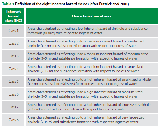
The inherent hazard classes are determined with respect to the inherent susceptibility (from low to high) of material to mobilise, and subsequent formation of a specific size sinkhole or subsidence (small to very large). This is based on the calculated potential size of these surface instability features and their inherent susceptibility to mobilise as determined for individual borehole profiles in SANS 1936-2 (SANS 2012).
The IHC for sinkhole and subsidence development can be expressed in terms of eight categories (IHC 1 to 8), which denote the probability of a sinkhole or subsidence of a specific size occurring, as summarised in Table 1. These eight classes are grouped into three broad categories, namely low (IHC 1), medium (IHC 2 to 4) and high (IHC 5 to 8) according to SANS 1936-2 (SANS 2012).
The manifestation of a sinkhole or subsidence at ground surface does not always define the depth and lateral extent of an instability (Kleinhans & Van Rooy 2016). The receptacle at depth that accommodates the eroded material may not be directly below the area of visual impact on the surface, but can be located at distances more than 20 m from the sinkhole or subsidence manifestation at surface. The evaluation of an event should therefore consider covering a surface area of between 20 m to 50 m around the sinkhole or subsidence area to ensure that the area of influence has been covered (Kleinhans & Van Rooy 2016).
PROBLEM STATEMENT
This paper discusses the efficiency of using point data to predict sinkhole hazard and size. This is used to compare the classified hazard of the borehole with the size of the sinkhole that has occurred within a 50 m radius from the borehole. The size of the sinkhole is defined as the volume of the sinkhole and will be explained later on in this paper.
METHODOLOGY
The sinkhole data and the borehole logs from the ENGEODE database have been used for this study. There are currently 5 171 sinkhole entries in the database, but only 546 have been used in this study. The limiting factors were dimensions that were not available for all entries, and the fact that a borehole had to be present within 50 m from the sinkhole.
The sinkhole database includes all sinkholes in South Africa and is subdivided into different municipalities or regions, namely the Far West Rand region, Tshwane, Ekurhuleni, Johannesburg and Sedibeng Municipalities and the Mpumalanga, North West and Northern Cape Provinces. Four regions were analysed: the Far West Rand, Tshwane and Ekurhuleni Municipalities as separate areas, while the rest of the data was combined to form a fourth group. For this comparison, sinkholes were selected that were up to 50 m away from a borehole. In a couple of cases, the hazard classification of boreholes in the vicinity was used if the information on the borehole was insufficient or not representative of the area.
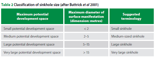
To compare the sinkholes with the borehole classification, an IHC value was assigned to each sinkhole, based on the diameter of the sinkhole and the volume of the sinkhole. The maximum volume for a small, medium and large sinkhole was calculated from the dimensions as specified by Buttrick et al (2001). These values are tabulated in Table 2, and a minimum depth of 1 m was used to calculate the volume of the size sinkhole. It was found that the assigned IHC value based on the volume differed less from the IHC of the borehole than the assigned IHC based on the diameter. For this study, only the IHC based on the volume of the sinkhole was taken into consideration. It was further assumed that the area around the sinkhole reflected a high inherent hazard, thus IHC values of 5 to 8 were assigned to the sinkholes.
The comparison of the IHC values was thus undertaken from two perspectives: (a) to determine whether the hazard has been accurately predicted (thus IHC values of 5 to 8 and not IHC values less than 5), and (b) whether the size of the sinkhole corresponds to the IHC value of the borehole. The percentages of the overestimated, correct and underestimated classifications of the boreholes versus the sinkholes are presented in Figure 1.
The classifications of the boreholes were verified individually. Nine percent of the classifications were corrected, implying that a higher hazard was allocated than the initial classification, while four percent were borderline IHC 3/4 or IHC 6, in which case the latter was chosen as the inherent hazard classification. Twelve percent of the classifications were correct, but were changed to a higher hazard classification due to the classification of the surrounding boreholes; thus the geological conditions of the boreholes in the area were worse than the borehole originally classified. In total, an adjustment was made to 25% of the classifications of the boreholes in the database. For the rest of the classifications, only the borehole log was taken into account and not the general geological conditions of the area.
The groundwater table was incorporated in the classifications as per the method proposed by Oosthuizen and Van Rooy (2015). The comparison in this paper considered the ingress scenario of the boreholes and did not take the dewatering scenario into account.
COMPARISON
Direct correlation of the IHC values
The inherent hazard classifications (IHCs) of the individual boreholes and the IHCs of the corresponding sinkholes are compared in Figure 1. Only approximately one quarter is deemed classified correctly (23%), while half of the IHCs of the boreholes are generally underestimating the size and risk of the sinkhole, with 26% of the boreholes overestimating the sinkhole size and/or hazard.
Although only a small representation is classified correctly, 61% of the classifications in the Tshwane Municipality area differed by one value, i.e. one class up or down from the sinkhole hazard classification. This represents 67% for the Ekurhuleni Municipality, 56% for the Far West Rand region and 65% in the other provinces, as illustrated in Figure 2. This indicates that there is a relatively good IHC correlation between the hazard classification of the boreholes and the sinkhole sizes.
Classifications with too low risk
As discussed previously, the areas where sinkholes occur should be classified in terms of high risk. This suggests that IHC values from 1 to 4 are not deemed satisfactory in an area where sinkholes occur. In the Tshwane Municipal area, 22% of the boreholes were classified with IHC values of 4 and lower, suggesting a low to medium hazard for sinkhole formation. For the Ekurhuleni Municipality, this figure is 17%, in the Far West Rand region 24% and for the other provinces 29%.
The correlation between the classification of the borehole and those of the sinkhole is visually indicated in Figure 3. The larger circle is colour-coded for the IHC of the sinkholes, while the smaller circle represents the IHC of the borehole. Where the colours are the same, it suggests a good correlation for hazard classification between the sinkhole and the borehole in proximity thereof. However, if a lighter colour is present within the sinkhole marking, it suggests that the size of the sinkhole has been underestimated. The blue, green and yellow dots indicate that the hazard has been undervalued as either low or medium risk for sinkhole formation, thus IHC 1 to 4 classifications.
CONCLUSION
Although a very high percentage has been underestimated (ranging from 42% to 59% for the different regions), there is a relatively good IHC correlation between the hazard classification of the boreholes and the sinkholes. The number of classifications that are correct and differ by one value, is 61% in the Tshwane Municipality area, 67% for the Ekurhuleni Municipality, 56% for the Far West Rand region and 65% in the other provinces. The current methodology to classify the boreholes has not proved to be one hundred percent accurate to predict the size of the sinkhole for the area.
The other fact is that an IHC of 1 to 4 (low to medium risk) was assigned to the boreholes in 17% to 29% of the cases for the different areas. These areas are more problematic, since the risk has been under-estimated from the drilling.
The areas where discrepancies occurred have been assessed in terms of the subsurface conditions and hazard classifications of the boreholes in the immediate vicinity. During the correction of the classifications of the boreholes, the following factors were noted:
■ Many boreholes were too shallow to classify appropriately (30 m and less in depth).
■ Classification changed when boreholes in the area had a higher hazard classification.
■ Deep competent overburden profiles, but underlain by cavities and/or weak soil.
■ Deep competent profiles, especially in the Far West Rand, but still sinkholes occurred in the area.
■ Shallow dolomite in an area, but the hazard not classified as high.
■ Boreholes classified as borderline between high and medium hazard.
It is important to take note that when a profile has cavities or weak soil in the profile, even if a thick overburden is present, sinkholes can occur. These boreholes should rather be classified with IHC 6 or higher to incorporate the high risk of sinkhole occurrence. In a shallow dolomitic area, the risk for small sinkholes to form is high, and the classification of the boreholes should reflect that.
It is important to take cognisance of the boreholes in the vicinity when assessing a site. Boreholes with a high hazard can contribute to the instability of the area. In an area with shallow dolomite bedrock, the risk for the occurrence of small sinkholes is higher than generally anticipated. Deep competent profiles have a profound influence on the instability of the area, and alternative ways to determine the stability of these areas should be investigated. Another factor that might be included in this process, is to determine whether the type of overburden has an influence on the formation of sinkholes and whether it can be recognised in the borehole or other laboratory tests. Further research needs to be carried out around the discrepancies between the IHC of boreholes compared to actual sinkholes.
REFERENCES
Buttrick, D B 1992. Characterization and appropriate development on sites on dolomite. PhD Thesis. University of Pretoria. [ Links ]
Buttrick, D B & Van Schalkwyk, A 1995. The method of scenario supposition for stability evaluation of sites on dolomitic land in South Africa. Journal of the South African Institution of Civil Engineering, 37(4): 4-14 [ Links ]
Buttrick, D B, Van Schalkwyk, A, Kleywegt, R J & Watermeyer, R B 2001. Proposed method for dolomite land hazard and risk assessment in South Africa. Journal of the South African Institution of Civil Engineering, 43(2): 27-36. [ Links ]
Kleinhans, I & Van Rooy, J L 2016. Guidelines for sinkhole and subsidence rehabilitation based on generic geological models of a dolomite environment on the East Rand, South Africa. Journal of African Earth Sciences, 117: 86-101. [ Links ]
Oosthuizen, T & Van Rooy, J L 2015. Hazard of sinkhole formation in the Centurion CBD using the simplified method of scenario supposition. Journal of the South African Institution of Civil Engineering, 7(2): 69-75. [ Links ]
SANS (South African Standard) 2012. SANS. 1936-2: Development of Dolomitic Land. Part 2: Geotechnical Investigations and Determinations. Pretoria: SABS Standards Division. [ Links ]
Sartain, N, Mian, J, O'Riordan, N & Storry, R 2011. Case study on the assessment of sinkhole risk for the development of infrastructure over karstic ground. In Vogt, N, Schuppener, B, Straub, D & Bräu, G (Eds). Proceedings, 3rd International Symposium on Geotechnical Safety and Risk (ISGSR 2011). 2-3 June 2011, Munich, Germany. [ Links ]
Wagener, F von M 1982. Engineering construction on dolomites. PhD Thesis. Pietermaritzburg: University of KwaZulu-Natal. [ Links ]
 Correspondence:
J Bunk
Council for Geoscience, Private Bag X112
Pretoria 0001, South Africa
E: jbunk@geoscience.org.za

JANET BUNK completed a BSc (Hons) in Geology and Engineering Geology in 1999. She started her career in the mining environment with SRK and was seconded to Navachab, Namibia, to monitor the stability of the mine until 2002. She then did contract work for various companies, amongst others Aurecon/Zutari, until 2018 when she joined the Council for Geoscience. She is currently involved with research on dolomite, ranging from zonation efforts from available data, fundamental testing of materials, early warning systems for sinkholes, advising and monitoring of sinkholes in the country, and shallow geotechnical investigations.

