


Services on Demand
Article
 English (pdf)
 Article in xml format
 Article references
Indicators

Related links
-
 Cited by Google
 -
 Similars in Google
Share

 Permalink
Journal of the South African Institution of Civil Engineering
On-line version ISSN 2309-8775
Print version ISSN 1021-2019
J. S. Afr. Inst. Civ. Eng. vol.65 n.1 Midrand Mar. 2023
http://dx.doi.org/10.17159/2309-8775/2023/v65n1a3
TECHNICAL PAPER
Using pedological information in preliminary stage geotechnical investigations for strategic urban planning in South Africa
F Calitz
ABSTRACT
Urban development in South Africa should be preceded by a preliminary stage geotechnical investigation to facilitate decision-making regarding site selection and project feasibility, and to aid the Environmental Impact Assessment process. These desk studies generally rely on information obtained from published sources, including regional geotechnical maps, typically only available for major urban centres. It is proposed that use be made of pedological information contained in published land type inventories available for most of the country, or resulting from detailed soil mapping surveys. The proposed refined Soils Effects Grouping (SEG) system provides a relatively simple scientifically based tool that allows conversion of pedological information into the relevant geotechnical parlance in accordance with industry-standard parameters suitable for use in preliminary stage geotechnical investigations. Application of this system over a period of more than a decade has provided cost-effective and reasonably accurate results in support of urban planning and Environmental Impact Assessments.
Keywords: SEG, pedological, geotechnical, strategic, planning
INTRODUCTION
All residential development within the Republic of South Africa must by law (Republic of South Africa, National Building Regulations and Building Standards Act 103 of 1977, as amended) be preceded by at least a preliminary stage geotechnical assessment, i.e. a desk study, during which the suitability of a parcel of land earmarked for development is evaluated in terms of the available geological, geotechnical and geomorphological information (Calitz & Hattingh 2007; SANS 2012). The results of this type of study are essential elements in the decision-making processes that form part of initial planning regarding the optimum placement of urban development in relation to soils and geology (Partridge et al 1993). The Code of Practice of the Geotechnical Engineering Division of the South African Institution of Civil Engineering (SAICE 2010) states that typical major civil engineering projects, including infrastructure routes, generally commence with the conducting of a pre-feasibility investigation comprising a desk study, with results generally verified by means of a site inspection or walkover survey.
Additionally, although not specifically mentioned by the National Environmental Management Act (NEMA) (Republic of South Africa, National Environmental Management Act 107 of 1998, as amended), generalised geotechnical information is regularly requested as specialist input for the compilation of the Basic Assessment Report (BAR) that forms part of the Environmental Impact Assessment process according to NEMA (Republic of South Africa, National Environmental Management Act 107 of 1998, as amended).
DEFINING A PRELIMINARY STAGE GEOTECHNICAL INVESTIGATION
Preliminary stage geotechnical investigations (PSGIs) as defined by SANS 634 (SANS 2012) comprise the "... critical evaluation of information, with the aim of guiding decisions of an issue of public interest ..." (Scholes et al 2017). The relevant national standards and guidelines pertaining to urban development are led by SANS 634 (SANS 2012) that states the following regarding the conducting of PSGIs:
"Section 4.2.1 The preliminary investigation is commissioned by the client to establish whether or not a parcel of land is suitable for township development."
SANS 634 (SANS 2012) requires collation and reporting of information and opinions on issues of a geological and geotechnical nature, including:
■ a discussion of the process behind the delineation of preliminary geotechnical zones (also named terrain mapping units) with reference to the classification system proposed by Partridge et al (1993)
■ a discussion of the generalised geotech-nical characteristics of the covering soils, with specific reference to the presence of outcrops, based on the interpretation of maps and remote-sensing images, available information from other investigations in the area, and observations made during walkover surveys or inspections
■ a description of any significant physical surface soil conditions (e.g. floodplains, erosion dongas, undrained depressions, or talus slopes) present within the study area
■ an assessment of the possibility of seasonal or prolonged groundwater seepage
■ a discussion of the structural integrity of existing structures within the study area (where present) as indicators of the possible presence of problem soils
■ a detailed drawing of the study area showing the resultant preliminary geotechnical zones based on the system proposed by Partridge et al (1993).
In some cases, limited field work mainly comprising a walkover survey and the inspection of exposed soil and rock layers within existing trenches or excavations, is conducted to corroborate desk study results, although this could significantly increase the cost of the study.
CURRENT INDUSTRY PRACTICE
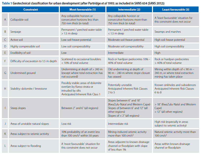
The system currently in use by engineering geological practitioners in South Africa to assess regional geological and geotechnical information for urban development was proposed by Partridge et al (1993). That system comprises a standardised classification system whereby the results of PSGIs for residential development can be measured using a decision-making matrix that assesses the perceived influence (classified as Class 1 -most favourable, Class 2 - intermediate, and Class 3 - least favourable) of 12 geotechnical constraints (numbered from A - least problematic, to L - severely problematic) (see Table 1). The results of this assessment are summarised for each preliminary geotechnical zone within a study area through pooled alphanumeric labels reflecting the assumed level of effect for each relevant constraint based on the inferred geotechnical characteristics of that specific area (Partridge et al 1993). According to Kleinhans (2002) this system is endorsed by the South African Institution of Engineering (SAICE), the South African Institute for Engineering and Environmental Geologists (SAIEG) and the National Home Builders Registration Council (NHBRC 2015), and has been included in the SANS 634 (SANS 2012) standards regarding geotechnical investigations for residential development.
Decision-makers also typically require an assessment of the re-use potential of the natural materials to be encountered during development, and the trafficabil-ity of the site during construction. The assumed occurrence of self-mulching soil and/or slaking rock is also of importance. However, the above-mentioned standards do not provide guidance in this regard.
REGIONAL GEOTECHNICAL MAPPING
General
Cost-effective, environmentally sustainable urban development is dependent on the rapid and accurate identification of geologically or geotechnically stable land (Kleinhans 2002). This is generally addressed by means of regional geotechnical mapping, usually conducted at the hand of several systems, ranging from simple to very complex, developed over time for use in South Africa. Kleinhans (2002) concluded that those systems based on the parameters proposed by Partridge et al (1993) are the most practical for the classification of land for urban planning and development, of which the system developed in-house by the Council for Geoscience is deemed the most comprehensive and useful. However, the 1:50 000-scale maps produced by means of that system at the present number only cover portions of some urban centres (i.e. Cape Town, Johannesburg, Polokwane and Tshwane), and as such urban development in rural areas has to either rely on other sources of regional geotechnical information or require time-consuming site-specific mapping. The Council for Geoscience has recently embarked on a multi-year programme to greatly extend the coverage of the 1:50 000-scale geotechnical maps within the borders of South Africa (Meintjes 2019).
However, a generally overlooked source of information, namely the results of regional soil mapping, primarily available as the 1:250 000-scale land type inventories but occasionally as the results of soils mapping surveys, could provide a readily available source of regional pedological information for most of South Africa. The Department of Agriculture, Land Reform & Rural Development (DALRRD) has recently re-activated an online version of the whole inventory, providing free access to the relevant inventories contained within the Comprehensive Atlas Version 3 available through their webpage (DALRRD 2023).
Application of pedological information
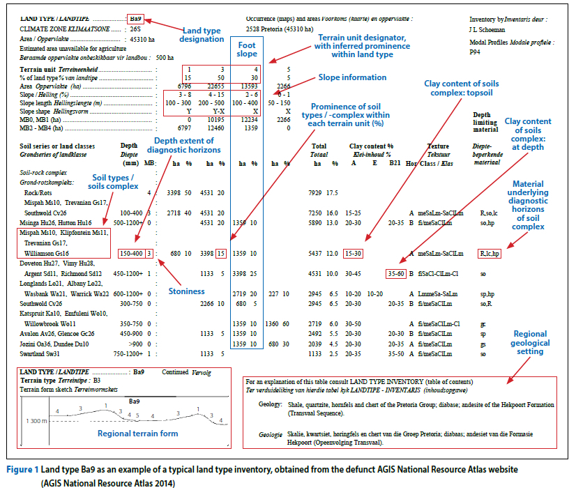
Paige-Green and Turner (2007) define land types as areas that exhibit distinct uniformity with regard to climate, terrain form and soil types, with sub-division into terrain units defined as areas exhibiting relatively homogeneous form and slope (indicated graphically on the bottom left of Figure 1 on page 21). It must be noted that the above-mentioned terrain units roughly correspond to (albeit on a more simplified level) the landforms as defined by Croukamp (1996) used within the engineering geological fraternity as basic mapping units during the conducting of geotechnical mapping studies on a regional scale. The land type inventories provide information on the following factors of interest to initial geotechnical assessments (Figure 1):
■ regional terrain form, with a graphical representation of the distribution of terrain units, as well as information regarding slope angles and shapes (bottom left, Figure 1)
■ regional geological setting (bottom right, Figure 1)
■ dominant soil forms and series for each terrain unit, including soil / rock complexes, with short summaries of the estimated depth ranges, clay content, texture classes (based on regional soils mapping by means of the Binomial Soil Classification System (MacVicar et al 1977))
■ a generalised indication of the depth-limiting materials and/or factors underlying the succession of soil, rock and/or pedogenic layers comprising the relevant soil form (right-most column, Figure 1).
Pedological information, especially the land type inventories, has to date been erroneously viewed by most geotechnical practitioners as being applicable only in agricultural potential studies. However, several authors (e.g. Fanourakis 1990) have proposed empirical systems to infer geo-technical properties for the different soil types contained in land type classifications, but these have not been adopted by the engineering geological fraternity, mainly due to its generalised nature, and a reliance on intimate knowledge of the principles behind pedological mapping and the different soil classification systems of South Africa that few geotechnical practitioners are familiar with (Paige-Green & Turner 2007). Conversely, the various soil classification systems for South Africa hold great promise in providing information on the nature and behaviour of the soil-like material of specific interest to geotechnical practitioners, provided a suitable system can be devised to allow translation thereof for use within the geotechnical fraternity.
Background on soil classification in South Africa
Binomial Soil Classification System (1977)
The science behind soil formation, rather a separate system for specific applications (e.g. agriculture or engineering) in use in other parts of the world, was used to devise the Binomial Soil Classification System (BSCS) for the mapping of soils in South Africa (MacVicar et al 1977). This classification system relies on five diagnostic topsoil and 15 subsoil horizons based on differences in soil structure, texture, appearance, composition and origin stemming from soil-forming processes. A total of 41 soil forms, each comprising a unique vertical succession of diagnostic horizons, were defined. It must be noted that the materials underlying those defining the diagnostic soil forms are not included in the detailed soils description (deemed non-diagnostic materials). Further differentiation based on clay content, lime content, colour and/or discoloration, degree of leaching, and pH describes a total of 504 Soil Series. The vertical succession of soil layers to a maximum depth of roughly 1.2 m at any given location is thus described as both a Soil Form and Soil Series.
Taxonomical Soil Classification System (1991)
A successor to the Binomial Soil Classification System, named the Taxonomical Soil Classification System (TSCS), was published in 1991 (Soil Classification Working Group 1991). This system replaced the Soil Series subclassification with broader Soil Families based on some of the principles behind the earlier subdivision but adding additional parameters such as the presence or absence of signs of wetness, and a significant increase in clay content with depth (so-called 'luvic' horizons). Additionally, the maximum depth to which diagnostic horizons are mapped was increased to 1.5 m. This new system also introduced several new diagnostic horizons, subsequently defining a total of 73 Soil Forms.
Although the Taxonomical System provides much more detailed soils information, and has been extensively used for at least two decades, soils mapping based on this system, especially on a regional scale, is not readily available to geotechnical practitioners, as these are generally privately funded.
Natural Soils and Anthropogenic Materials Classification System (2018)
Advances in the field of soil science since 1991 have led to the development of a greatly enhanced third edition of the South African soil classification system, namely Soil Classification: A Natural and Anthropogenic System for South Africa (NASCS) (Soil Classification Working Group 2018). The new system was developed primarily to reflect the importance of soil as a natural entity, and to stimulate the interest of soil scientists in the observation and classification of the soil blanket affecting agriculture, hydrology and the environment, with the results of research regarding the effects of the lateral movement of profile water being of particular importance (Soil Classification Working Group 2018). A limit of 1.5 m was selected to represent the maximum extent for soil form classification, but allowance was made to incorporate the influence of agricultural and environmental issues on the soil-to-substratum interface and deep substratum continuum in line with emerging global soil taxonomy insights (Soil Classification Working Group 2018). Soil designations generally comprise the soil form name and family code, followed by any additional diagnostic horizons where present, ending with the limiting depth quoted in brackets (where relevant), for example: Av2210/al/gl (260 cm).
Changes regarding the principles and structure of the new soil classification system include the following, deemed of interest to the geotechnical practitioner:
■ Natural soils and anthropogenic materials are differentiated.
■ Classification of soil forms relies on an 'open system' that allows inclusion of additional soil horizons beyond those comprising the standard soil forms, thus facilitating description of both whole and partially observable soil profiles.
■ Prior restrictions on the position and sequence of diagnostic horizons, strictly classified according to the relevant criteria, have been relaxed, allowing a more accurate description of the properties of a given soil profile.
■ Introduction of a peat horizon.
■ Prominence is given to indications of soil wetness and/or prolonged saturation (gleying) within soil diagnostic horizons.
■ The bleached character of certain sub-surface horizons that contain more clay than the overlying layer and undergo periodic saturation while acting as conduits for the lateral movement of soil water, is emphasised.
■ Podzolic characteristics have been granted more prominence.
■ Lithic characteristics have been sub-divided into saprolithic, geolithic and gleylithic materials.
■ Hard rock is classified as either fractured, or solid rock.
■ The occurrence of relatively thick unconsolidated material exhibiting signs of wetness that does not allow classification as a gley, gleyic or albic horizon, has been accommodated.
Contributions from hydropedology
Recent studies in the relatively new field of hydropedology have expanded understanding of the presence and movement of soil moisture, as well as defining its influence on the character of the different soil forms. Work by Van Tol and Le Roux (2019) have led to the grouping of the Taxonomic Soil Classification System (TSCS) soil forms into the following four classes:
■ Recharge soils, characterised by the presence of shallow or fractured rock, or deep freely draining soils, where vertical flow through and out of the material dominates.
■ Interflow soils, where lateral movement of soil moisture occurs along either the contact between the topsoil and sub-surface soil horizons, or between the soil / bedrock interface.
■ Responsive soils, typically responsible for overland flow due to the presence of relatively impermeable material or soils that undergo prolonged saturation close to the surface.
■ Stagnating soils, where the outflow of soil moisture is limited or restricted.
In this light it is evident that application of hydropedological principles could play an important role during the assessment of the geotechnical properties of natural materials occurring within a study area, especially regarding the determination of periodic or prolonged saturation thereof.
A new approach
In light of the apparent importance of regional pedological information, including the readily available land type maps and memoirs, the proposed refined Soils Effects Grouping (SEG) system utilising a standardised and diagrammatical reporting format was developed to allow use thereof during the conducting of PSGIs. This system provides an easy-to-use bridge between the pedological and geotechnical worlds of particular use in areas where more detailed regional geotechnical maps are not available.
Presentation of the initial version of the resultant SEG system was well received at an international conference in 2007 (Calitz & Hattingh 2007), and has since been in use in practice by several geopractitioners. However, establishment of the NASCS, and updated industry standards and legislation have necessitated refinement thereof. The processes and principles behind this new system were discussed in detail in the author's PhD thesis (Calitz 2022), but embodies a volume of work too large to include in this document without significant reworking; hence the following section provides a summary of these processes and principles.
THE REFINED SOILS EFFECTS GROUPING (SEG) SYSTEM
Considering the (sometimes) highly variable nature of the different soil forms comprising any given land type, it is essential to define a series of data groupings to facilitate the collation of the inferred soil characteristics across the area without allowing the behaviour of the dominant soil forms from drowning out those of less prominent soil forms. For example, the inundated character of a localised occurrence of clayey soil that undergoes prolonged saturation could be as important to the investigation as a large volume of sandy apedal soil material.
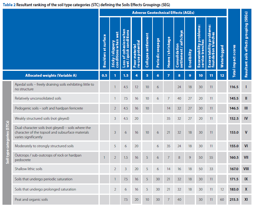
Empirical experimentation over time led to the definition of 12 unique Soil Type Categories (STCs), numbered from I to XII (see Table 2) formed by the grouping together of the NASCS soil forms (and by implication the less refined soil forms of the BSCS) exhibiting roughly similar geotechnical characteristics regarding urban development, such as soil structure, degree of ferruginisation, or gleyic characteristics, and allowing for the presence of scattered to extensive bedrock outcrop. Definitions of the various STCs were primarily influenced by the following:
■ soil groups, based on the BSCS soil forms, defined by Fey (2010)
■ adverse geotechnical characteristics inferred to be exhibited by specific soil forms proposed by Harmse (1977), Brink (1985) and Fanourakis (1990)
■ soil groups based on inferred geotechnical properties as proposed by Hattingh (1995)
■ primary geotechnical characteristics as proposed by Partridge et al (1993)
■ classification of the various soil forms according to hydropedological principles (Van Tol & Le Roux 2019).
It must be noted that further assessment of the anthropogenic soils (Categories XI and XII) was not conducted, as the adverse characteristics generally exhibited by these types of soil do not readily allow cost-effective residential development, and more specifically low-cost housing, that forms the main aim for application of the refined SEG system.
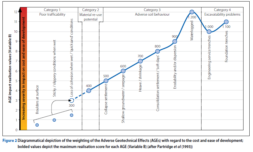
In order to rank the perceived impacts of each of the STCs on urban development, it was necessary to define a series of ten Adverse Geotechnical Effects (AGEs), ranked from least costly to most costly according to the succession of parameters as stated by SANS 634 (SANS 2012) based on Partridge et al (1993) (see Table 1), but expanded to include parameters regarding poor trafficability and material re-use potential, and placing more importance on the effects of prolonged saturation. These AGEs were grouped into categories with a weighting system (Variable A, Table 2) devised to broadly reflect an increase on the perceived level of impact of each AGE on the ease and cost of development (for example, the occurrence of boulders at surface deemed relatively easy to remediate is assigned the lowest weight value of 0.5, while the very high cost of mitigating the effects of prolonged saturation is reflected by the highest weight value of 12). The following AGE categories were defined:
■ Category 1: Poor trafficability
■ Category 2: Material re-use potential
■ Category 3: Adverse soil behaviour
■ Category 4: Excavatability problems
■ Category 5: Miscellaneous geological, geotechnical, and geomorphological parameters.
NOTE: These factors cannot be assessed in terms of regional soils information, and as such do not form part of the following discussion.
A diagrammatical representation of this weighting system, with the resultant maximum realisation values for each AGE (Variable B), is provided in Figure 2.
A simple matrix (Table 2) was devised to rank the various STCs by plotting the list of STCs (rows) against the AGEs (columns). The value of each cell was calculated as the product of the following two factors:
■ a value from 1 to 12 assigned to each of the twelve AGEs (as indicated by the AGE sub-header in Table 2) broadly based on its inferred effect on the cost of development (from Partridge et al 1993), with the exception of the AGE waterlogged (typically grouped under Category 3) considered a worst-case scenario and as such assigned a value of 12
■ the inferred prominence of each AGE within a specific STC, given as a value graded on a scale from 0 to 5 as follows: 0: effect exhibited by none of the soils within the specific STC
1: effect exhibited by only a very few soils within the specific STC, or occurs very occasionally
2: effect exhibited by some soils within the specific STC, or occurs infrequently
3: effect exhibited in roughly half of the soils within the specific STC, or occurs occasionally
4: effect exhibited by most of the soils within the specific STC, or occurs frequently
5: effect exhibited by all of the soils within the specific STC, or invariably occurs.
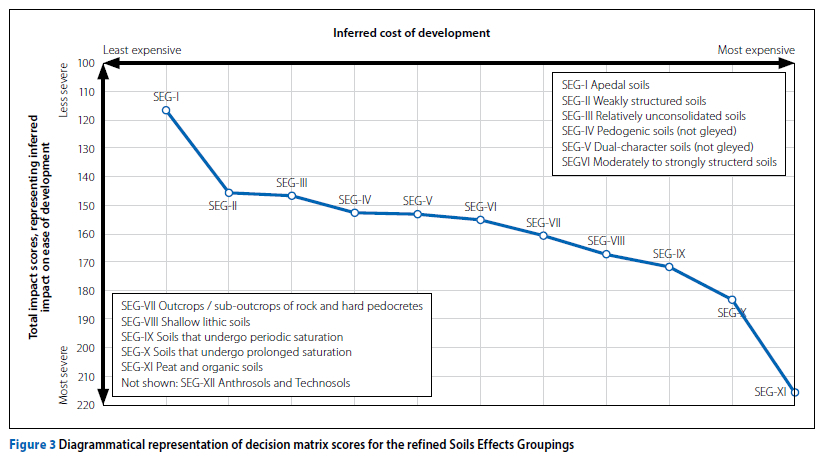
The resultant total impact scores for each of the STCs were obtained by the sum of the individual matrix scores (reflected by the second-to-last column in Table 2). By plotting the inferred impact against the inferred cost of development, the STCs could be ranked from the lowest total impact score, deemed to define those soil forms that have the smallest impact on development, to the highest total impact score, expected to be the most costly and difficult to remedy (Figure 3). The outcomes were used to rearrange the STCs according to their ranking, and as such define the series of 12 Soils Effects Groupings (SEGs), numbered from SEG-I to SEG-XII (last column of Table 2, as illustrated diagrammatically in Figure 3). This numbering system forms the basis of the proposed refined method to facilitate use of pedological information in the conducting of PSGIs.
APPLICATION
Framework
Implementation of the refined SEG system relies on the efficient collation of land type information or the results of more detailed soil mapping surveys. The implementation process involves the following steps (illustrated in Figure 4):
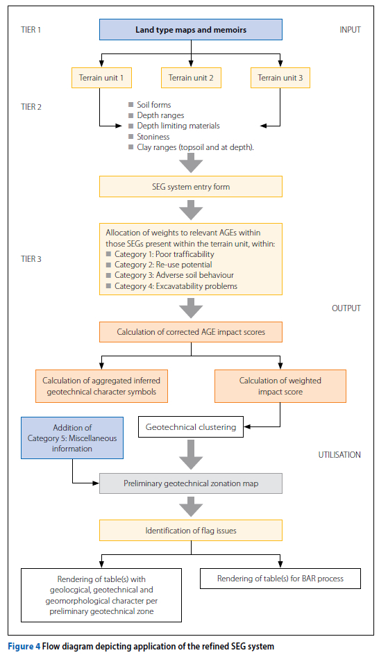
■ Input, comprising:
■ dissemination of pedological information for each relevant mapping unit
■ assignment of contribution weights per AGE within each relevant SEG to define the overall geotechnical character
■ Output, rendering of results in tabular and diagrammatical format
■ Implementation, comprising reworking of the disseminated information to facilitate:
■ geotechnical clustering and delineation of preliminary geotechnical zones
■ identification of flag issues for planning purposes
■ furnishing of geotechnical information for Basic Assessment Reports (BARs).
Input
■ Tier 1: Regional pedological information based on the BSCS can readily be obtained by means of the published 1:250 000-scale land type series maps and accompanying memoirs, available either as printed copies, or in digital format from the AGIS website of the Department of Agriculture (AGIS Natural Resource Atlas 2014). More localised soil maps based on the newer soil classification systems could, however, be obtained from landowners or other stakeholders, yielding more accurate and comprehensive pedological information.
■ Tier 2: The primary mapping unit for data entry is defined by terrain morphological units typically provided in columnar format by the land type inventory (as indicated in Figure 1). The following primary terrain units are defined:
■ ridge crests
■ scarp edges
■ mid slopes
■ foot slopes
■ valley floors.
These terrain units can be readily mapped using remote-sensing images and regional surface elevation information. Although the land type inventories provide an indication of the prominence of the different terrain units within the landscape, expressed as a percentage of the total surveyed area, these should preferably only be applied to very large sites, as smaller-scale development could be located wholly within only one or two terrain units. This parameter is not deemed a critical factor but is of value during the weighting of the aggregated soils information during the delineation of preliminary geotechnical zones at the culmination of PSGIs.
Regional soils information obtained either from the relevant land type memoirs or from other sources of regional soils mapping surveys is subsequently collated separately for each terrain unit under the relevant SEGs, with the following information entered:
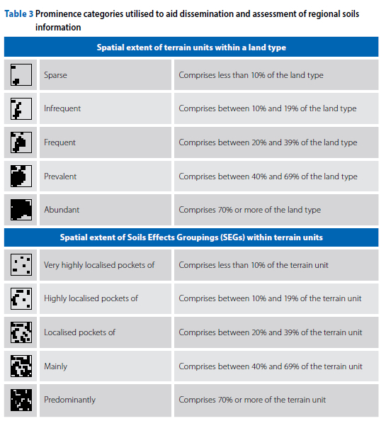
■ the occurrence of the various soil forms and soil / rock complexes, expressed as a percentage of the total surface area within the specific terrain unit (Variable C, noted as a number representing a fraction of 100), entered as separate entities under the relevant SEG with its inferred spatial prominences classified according to the empirically derived categories provided in Table 3
■ soil depth range, including both the stated minimum and maximum depths
■ the depth limiting material(s) underlying the diagnostic horizons (where noted)
■ the stoniness of the soil, representing the volume of coarse particles and/or clasts within the soil matrix
■ the minimum and maximum clay content for the topsoil and subsurface layers respectively (where noted).
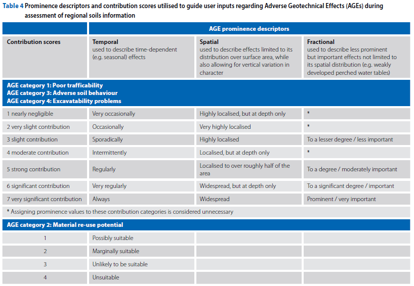
■ Tier 3: Dissemination of the pedological information is followed by the allocation of contribution scores based on decisions made by the geopractitioner reflecting the importance of the AGE within either of the following prominence categories:
■ inferred temporal importance (i.e. time-dependent effects, e.g. seasonal waterlogging)
■ inferred spatial importance (i.e. distribution within the surface area but also accounting for vertical variations in geotechnical character, e.g. the occurrence of gleyed clay beneath sandy topsoil)
■ inferred fractional importance (i.e. allowing inclusion of less prominent but important effects not limited to spatial distribution, e.g. the occurrence of weak perched water tables).
The chosen contribution scores (Variable D) for AGEs within AGE categories 1, 3 and 4 are classified as follows (upper portion of Table 4):
1. nearly negligible
2. very slight contribution
3. slight contribution
4. moderate contribution
5. strong contribution
6. significant contribution
7. very significant contribution.
A contribution score (Variable D) for AGE Category 2 is depicted using a different scale with the following values (lower portion of Table 4):
1. possibly suitable
2. marginally suitable
3. unlikely to be suitable
4. unsuitable.
It must be noted that the assignment of contribution scores is highly dependent on the personal experience of the geopractitioner regarding the expected behaviour of the different soil types and the geotechnical and hydropedological character of soils occurring in the area in which the site is located.
Output
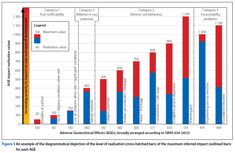
The expected severity level at which each AGE is expected to affect the cost and ease of development, expressed as a fraction of 100%, can be calculated as follows for each terrain unit present within a study area (see Figure 5):
■ STEP 1: Calculation of the relative importance of each AGE within the relevant SEG:
■ Weighted AGE contribution value (Variable E) = Variable D x (Variable C/100).
■ STEP 2: Calculation of AGE severity values collated for the whole terrain unit:
■ (Variable F) = Maximum possible contribution value for the AGE obtained from Table 4 (either 4 or 7).
■ (Variable G) = Sum of weighted AGE contribution scores (Variable Es) across all relevant SEGs present within the terrain unit.
■ AGE severity value (Variable H) = Variable G / Variable F. NOTE: yields a non-integer percentage.
■ STEP 3: Calculation of the expected level at which the impact of each AGE, weighted to represent the inferred contribution of that specific characteristic on the overall cost and ease of development, has been realised, that can be measured against the total inferred severity value for that AGE, as follows:
■ AGE impact realisation value = Variable H x Variable A. NOTE: yields an integer value.
A low level of realisation is considered to indicate a relatively small impact by that AGE on the overall geotechnical character of the soil and/or soil / rock complexes occurring within a terrain unit. Conversely, a severe impact is represented by a high level of impact realisation.
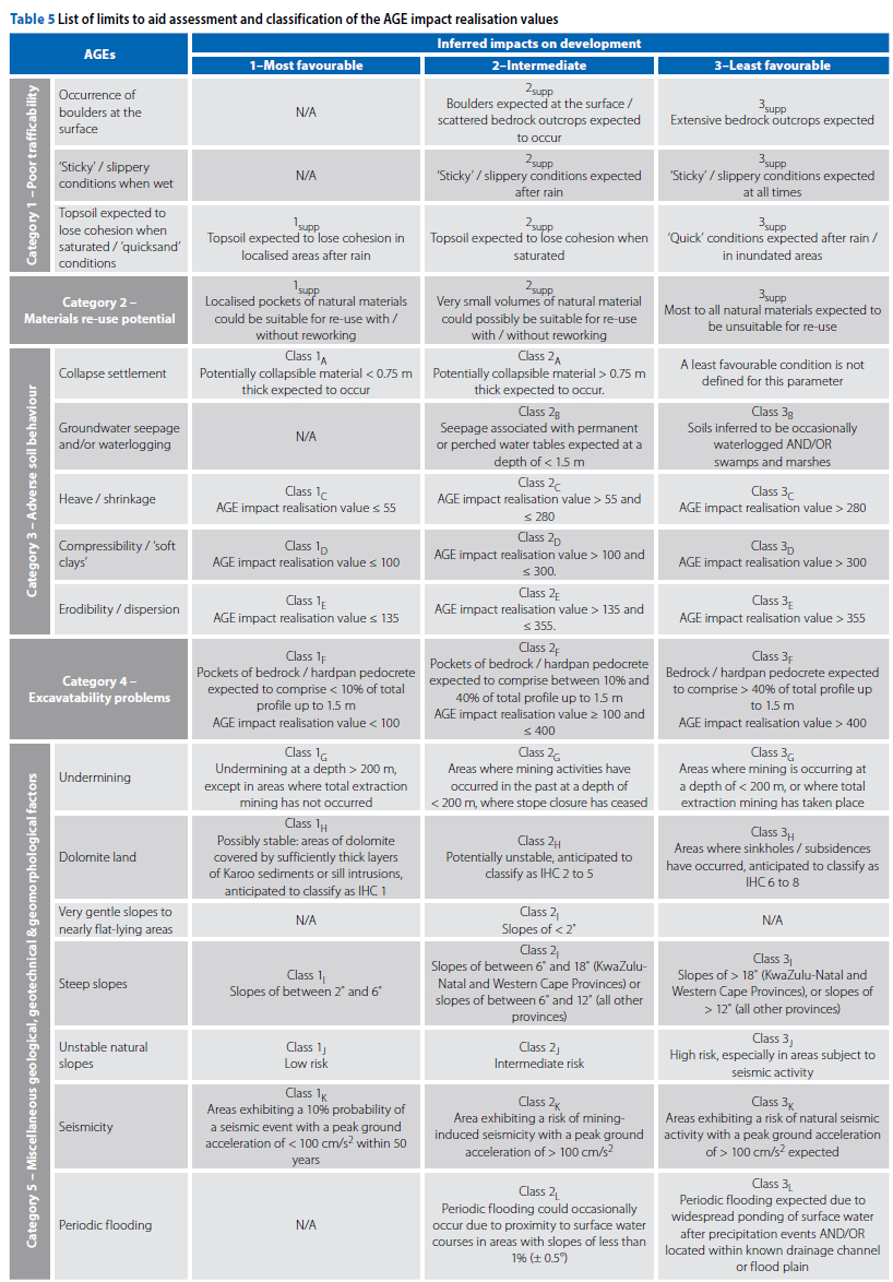
Comparison of these fractions with statistically determined limits for specifically potentially active and/or compressible soils allows allocation of inferred NHBRC geotechnical site classes for these AGEs. This determination was based on an assessment of the results of laboratory tests conducted on samples obtained from 32 development sites across South Africa measured against the reported NHBRC site classification (e.g. H2, S1, etc) where the AGE impact realisation values representing each of the relevant site classes readily clustered together, allowing the definition of limits that can be used to infer the NHBRC site classification for these AGEs. A similar method was used to define classification limits for potentially erodible soils, while limits for the other AGEs (Table 5) were determined according to their perceived impact graded according to the impact categories defined by Partridge et al (1993). These limits are provided in Table 5.
Implementation
The inferred NHBRC site classes, together with supplementary classification resulting from the assessment of other geological, geotechnical and morphological factors obtained from other sources, allow grouping of terrain units exhibiting similar geotechnical characteristics into preliminary geotechnical zones - one of the primary products resulting from application of the refined SEG system.
Additionally, PSGIs utilising the refined SEG system yields a list of 'flag' issues of a geological, geotechnical and morphological nature (Table 5) of importance to facilitate comparison between different terrain units for site selection purposes, as well as to furnish relevant information required as specialist input for BARs as part of Environmental Impact Assessment processes. Results are typically rendered by means of a series of tables and diagrams, as well as GIS-based maps, also available via Cloud-based platforms.
Although this process sounds complex, the establishment of a relatively basic spreadsheet should easily manage the required data inputs and calculations, thus providing a simple, yet effective, overview of the overall geotechnical character of the different soils comprising each terrain unit.
AN EXAMPLE
Description of the study area
A PSGI utilising the refined SEG system was conducted on a land parcel approximately 25 ha in size located in the eastern suburbs of the City of Tshwane to assess its suitability for residential development. The study area exhibits the following relevant characteristics:
■ The area exhibits a humid climate, as evidenced by a Climatic N-value of approximately 2.4 (Weinert 1980).
■ Analysis of the available regional surface elevation information (JAXA 2021)
reveals that the land parcel represents a northeastwardly facing foot slope with natural slopes of less than 2°.
■ According to the published 1:250 000-scale 2528 Pretoria (CGS 1978) geological map, the site is expected to be underlain by andesite of the Hekpoort Formation that forms part of the Pretoria Group, Transvaal Supergroup, that typically decomposes into a highly expansive residual soil with occasional spheroidal boulders in a relatively humid climatic setting (Brink 1979). The area is not considered dolomite land or affected by undermining and is not located in an area at risk of significant seismic events.
■ The published 1:50 000-scale 2528CD Rietvlei Dam (CGS 2001) geotechnical map identifies the inferred occurrence of moderately expansive material with an expected heave in the order of between 5 mm and 30 mm, slight excavatability problems, and low soil permeability in the area.
■ Using information from the 1:250 000 scale 2528 Pretoria (Land Type Survey Staff 1987) land type inventory, the study area is inferred to be covered by soils of land type Ba9 typically representing plinthic (i.e. ferruginized) catenas dominated by the presence of leached red and/or yellow apedal soils, but without duplex or moderately structured soils in the uplands (predominantly comprising ridge crests and mid slopes).
Example - data input
The PSGI commenced with identification and dissemination of the relevant pedologi-cal information required to allow use of the refined SEG system. The following actions were taken:
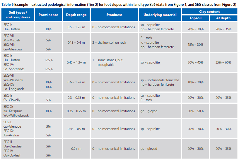
■ Tier 1: The study area wholly comprises a foot slope covered by soils of land type Ba9, with regional pedological information available from the relevant published land type inventory (marked with a blue box in Figure 1) with soil descriptions according to the BSCS.
■ Tier 2: Dissemination of the available pedological information yielded results as detailed in Table 6. It is evident that a variety of soil forms representing several of the SEGs, ranging from apedal soils to soils that undergo prolonged saturation, can be expected to occur within the study area.
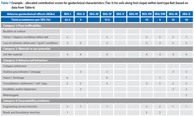
■ Tier 3: The inferred contribution of the different soil forms with regard to the list of AGEs was subsequently allocated for each SEG by an experienced geo-practitioner (Table 7).
Example - output
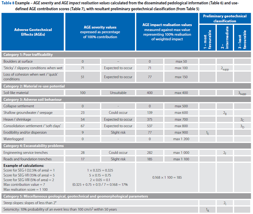
The AGE contribution scores resulting from the previous step were then used to calculate AGE severity and AGE impact realisation values (second column in Table 8, with an example of the calculations provided for AGE excavatability problems - roads and foundation trenches) that describe the inferred behaviour of the various soil forms considered present within the study area as a whole.
These values indicate that the soils covering the study area can be expected to exhibit the following adverse geotechnical characteristics:
■ poor trafficability when wet, including 'sticky' or slippery conditions and loss of cohesion
■ soil-like overburden (i.e. material typically described as a soil when using the MSSCTO profile geotechnical logging system, and could include saprolite)
is considered unsuitable for re-use as backfill material in its natural state
■ soil-like overburden is expected to exhibit a significant risk of heave / shrinkage and consolidation settlement, with a slight risk of erodibility and groundwater seepage
■ a slight risk of difficulties with the excavation of roads and foundation trenches, as well as a more significant risk of problems during the excavation of deep service trenches.
Results obtained by means of the refined SEG system allowed classification of the above-mentioned adverse characteristics according to the proposed system by Partridge et al (1993) as enhanced by the refined SEG system (Table 8).
Example - implementation
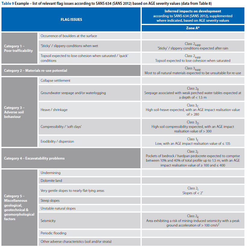
A list of 'flag' issues, now including Category 5 (miscellaneous geological, geotechnical and geomorphological information from non-pedological sources, as well as supplemental parameters resulting from application of the refined SEG system) is provided in Table 9.
In this light, the preliminary geotechnical classification for the foot slope comprising the whole study area can thus be expressed as follows (symbols explained in Table 9):
1E,K 2B,F,I 3C,D
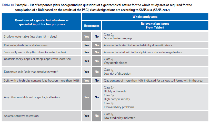
Additionally, the results of the PSGI were used to provide responses of a geotechnical nature for the BAR process. These responses and the relevant 'flag' issues on which these were based for the preliminary geotechnical zone comprising the whole study area are provided in Table 10.
CONCLUSIONS
The proposed refined Soils Effects Grouping system defines a geographical system by which readily available pedological information could be disseminated and combined with geological, geotechnical, hydropedological and geomorphological information obtained from other sources to render generalised geotechnical characteristics for a study area according to industry-standard parameters.
Reliance on the personal experience of the practitioner is built into the refined SEG system, thereby preventing use thereof as a 'recipe' by practitioners outside the engineering geological fraternity to conduct regional geotechnical assessments. This approach is considered beneficial to the geotechnical profession as a whole, as well as ensuring the trust of engineers, developers and other decision-makers depending on the accuracy of this information.
Utilisation of the refined SEG system is particularly useful in guiding the delineation of less suitable land parcels within large study areas or along linear routings. This aids cost-effective development by allowing developers to focus on the most suitable land portions. Additionally, the results of PSGIs based on the refined SEG system are of great benefit to geopractitioners during the definition and costing of detailed geotechnical investigations, with the anticipated adverse soil behaviour helping to guide planning of the number and type of expensive field and laboratory tests required.
Although predominantly applicable to the assessment of the geotechnical character of large sites, the conducting of PSGIs utilising the refined SEG system has been found to facilitate comparison between various candidate sites (e.g. for the establishment of a cemetery) or different routes for linear development (e.g. roads or pipelines) based on the resultant lists of fatal flaws (Table 7). The refined SEG system also provides adequate geotechnical information for small sites (e.g. an individual land parcel for the placement of a cellular mast) as specialist input during the BAR process.
Use of the proposed system in practice over a period of more than a decade revealed a number of limitations, especially with regard to the use of pedological information from the land type inventories where the depth limit of 1.2 m hampers accurate interpolation of geotechnical information at depth, while the accuracy of the land type boundaries should be assessed prior to use thereof.
It must be noted that the refined SEG system is not intended to replace, but rather enhance, the regional geotechnical maps being compiled by the Council for Geoscience, with results specifically engineered for ease of use by decision-makers not necessarily knowledgeable in geotech-nical matters. Conversely, the published geotechnical maps, where available, are of great value to verify the spatial accuracy of pedological information.
Although there are considerable time and cost benefits in obtaining preliminary geotechnical zones by the use of the refined SEG system, it is imperative to note that these should be considered of strategic value suitable for planning and/or informing the Environmental Impact Assessment process only.
In closure, the availability of more accurate pedological information resulting from soils mapping based on the new Natural and Anthropogenic Soil Classification System is eagerly awaited in order to feed more accurate soils information into the refined SEG system.
ACKNOWLEDGEMENTS
The author would like to thank Prof Marthie Coetzee and Dr Danél van Tonder of the Unit for Environmental Sciences and Management at the North-West University, his colleagues at AGES Alpha, and Mr Willem Meintjes of the Council for Geoscience, for their support and assistance.
Some acronyms used in the text:
AGEs Adverse Geotechnical Effects
BAR Basic Assessment Report
BSCS Binomial Soil Classification System
PSGI Preliminary Stage Geotechnical Investigation
SEG Soils Effects Grouping
STCs Soil Type Categories
TSCS Taxonomical Soil Classification System
REFERENCES
AGIS National Resource Atlas 2014. Natural resource atlas for South Africa. Pretoria: ARC-Institute for Soil, Climate and Water. https://www.agis.agric.za/agisweb/nratlas. Date of access: 23 September 2014 (no longer accessible online). [ Links ]
Brink, A B A 1979. Engineering geology of Southern Africa. Volume 1: The first 2 000 million years of geological time. Pretoria: Building Publications. [ Links ]
Brink, A B A 1985. Engineering geology of Southern Africa. Volume 4: Post-Gondwana deposits. Pretoria: Building Publications. [ Links ]
Calitz, F & Hattingh, J M 2007. The value of land type information with regard to initial geotechnical assessments in South Africa. In Bouassida, M, Ejezie, S U, Rust, E, Nouanga, P & Kana, E M (Eds). Proceedings, 14th African Regional Conference for Soil Mechanics and Geotechnical Engineering: Soils of Africa, Yaoundé, Cameroon, pp 31-36. [ Links ]
Calitz, F 2022. Proposed system to facilitate use of pedological information in preliminary stage geotechnical investigations. PhD Thesis. Potchefstroom: North-West University. [ Links ]
CGS (Council for Geoscience) 1978. 1:250 000 scale 2528 Pretoria geological map. Pretoria: CGS. [ Links ]
CGS 2001. 1:50 000 scale 2528CD Rietvlei Dam geotechnical map. Pretoria: CGS. [ Links ]
Croukamp, L 1996. An engineering geological Geographic Information System for land-use planning in South Africa. MSc Dissertation. University of Pretoria. [ Links ]
DALRRD (Department of Agriculture, Land Reform & Rural Development) 2023. Comprehensive Atlas V3. Available at: https://ndagis.nda.agric.za/portal/home. [ Links ]
Fanourakis, G C 1990. Engineering properties from pedological data. Volumes 1 & 2. Laureatus Thesis. Johannesburg: Technikon Witwatersrand. [ Links ]
Fey, M 2010. Soils of South Africa: Their distribution, properties, classification, genesis, use, and environmental significance. Cape Town: Cambridge University Press. [ Links ]
Harmse, H J von M 1977. Die interpretasie van pedologiese data vir ingenieursdoeleindes. Proceedings, 7th Conference of the Soil Science Association of South Africa, Pretoria. [ Links ]
Hattingh, J M 1995. Die verwantskap tussen ingenieursgeologiese eienskappe van grond en verskillende grondklasse. Die pedoloog se siening. Lecture notes. Pretoria: Council for Geoscience. (Unpublished). [ Links ]
JAXA (Japanese Aerospace Exploration Agency) 2021. Surface elevation contours. Available at: https://www.eorc.jaxa.jp/ALOS/en/dataset/aw3d30/aw3d30_e.htm. [ Links ]
Kleinhans, I 2002. A critical appraisal of regional geotechnical mapping in South Africa. MSc Dissertation. Pretoria: University of Pretoria. [ Links ]
Land Type Survey Staff 1987. Land types of maps 2526 Rustenburg and 2528 Pretoria. Memoirs of Agriculture Natural Resources South Africa, No 8. Pretoria: Department of Agriculture and Water Supply. [ Links ]
MacVicar, C M, De Villiers, J M, Loxton, R F, Verster, E, Lambrechts, J J N, Merryweather et al 1977. Soil classification: A binomial system for South Africa. Scientific Bulletin 390. Pretoria: Department of Agricultural Technical Services. [ Links ]
Meintjes, J W P 2019. Status of 1:50 000 scale geotechnical mapping being conducted by the Council for Geoscience (various telephonic discussions). Potchefstroom. [ Links ]
NHBRC (National Home Builders Registration Council) 2015. Home Building Manual. Pretoria: NHBRC. [ Links ]
Paige-Green, P & Turner, D 2007. The use of soil and land type information maps in road engineering in South Africa. In Bouassida, M, Ejezie, S U, Rust, E, Nouanga, P & Kana, E M (Eds). Proceedings, 14th African Regional Conference for Soil Mechanics and Geotechnical Engineering: Soils of Africa. Yaoundé, Cameroon, pp 311-317. [ Links ]
Partridge, T C, Wood, C K & Brink, A B A 1993. Priorities for urban expansion within the PWV metropolitan region. The primary of geotechnical constraints. South African Geographical Journal, 75(1): 9-13. [ Links ]
SAICE (South African Institution of Civil Engineering) (Geotechnical Division) 2010. Site Investigation Code of Practice, 1st edition. Midrand: SAICE. [ Links ]
Scholes, R J, Schreiner, G O & Snyman-Van der Walt, L 2017. Scientific assessments: Matching the process to the problem. Bothalia, 47(2): a2144. doi: 10.4102/abc.v47i2.2144. [ Links ]
SANS (South African National Standard) 2012. SANS 634. Geotechnical Investigations for Township Development, 1st edition. Pretoria: SABS Standards Division. [ Links ]
Soil Classification Working Group 1991. Soil classification. A taxonomical system for South Africa. Series: Memoirs on the Agricultural Natural Resources of South Africa, No 15. Pretoria: Department of Agricultural Development. [ Links ]
Soil Classification Working Group 2018. Soil classification. A natural and anthropogenic system for South Africa. Pretoria: ARC-Institute for Soil, Climate and Water. [ Links ]
Van Tol, J J & Le Roux, A L 2019. Hydropedological grouping of South African soil forms. South African Journal of Plant and Soil, 36(3): 1-3. doi: 10.1080/02571862.2018.1537012. [ Links ]
Weinert, H H 1980. The Natural Road Construction Materials of Southern Africa. Pretoria: H & R Academica. [ Links ]
Acts
Republic of South Africa. National Building Regulations and Building Standards Act 103 of 1977 (as amended).
Republic of South Africa. National Environmental Management Act 107 of 1998 (as amended).
 Correspondence:
Fred Calitz
AGES Alpha
PO Box 19460, Noordbrug, 2522, Potchefstroom, South Africa
ORCID: 0000-0001-7286-7381
E: fcalitz@ages-group.com

DR FRED CALITZ (MSAIEG) holds a PhD in Environmental Sciences, an MSc in Soil Science and a BSc in Engineering Geology. He specialises in the application of regional soils, and geological, geotechnical and morphological information in support of strategic planning for proposed development, as well as in the writing of technical reports. Over a period of 33 years he has conducted engineering geological investigations for a great variety of projects throughout South Africa, initially working from Polokwane and more recently from Potchefstroom, as well as in several other African countries. He is also involved in dolomite stability investigations and the compilation of dolomite risk management strategies and plans. He currently works as Project Manager (Geotechnical Unit) at AGES Alpha.

