


Services on Demand
Article
 English (pdf)
 Article in xml format
 Article references
Indicators

Related links
-
 Cited by Google
 -
 Similars in Google
Share

 Permalink
Journal of the South African Institution of Civil Engineering
On-line version ISSN 2309-8775
Print version ISSN 1021-2019
J. S. Afr. Inst. Civ. Eng. vol.64 n.1 Midrand Mar. 2022
http://dx.doi.org/10.17159/2309-8775/2022/v64n1a1
TECHNICAL PAPER
A mathematical model for determining engineering soil classifications from pedological data
G C Fanourakis
ABSTRACT
Various pedological soil classification systems exist worldwide, including an internationally accepted system and various national systems, many of which have been incorporated into databases that include maps. Various physical and chemical soil properties are used for classifying soils according to these pedological systems. This paper proposes an approach which may be used to determine the engineering properties of soils from the physical and chemical properties that are used to pedologically classify soils by systems, and, in particular, the South African Binomial System. These engineering properties include the USCS and AASHTO classification groups which may, in turn, be used as a means of rapidly determining the general suitability of areas for proposed development, particularly during the reconnaissance investigation stages of transportation route locations and township developments, with a resultant saving of time and money. The model was verified using data from the study area, as well as from an area located approximately 190 km from the study area. A total of 88% of the classification groups determined by the model, in the study area, were correct. Furthermore, only 6% of the classifications were incorrect by a maximum of two groups. The classifications determined for the soils outside the study area were all correct.
Keywords: pedology, soil classification, geotechnical engineering, models
INTRODUCTION
Pedology and pedological classification systems
Pedology is a branch of soil science which deals with the scientific study of soils, without a view to any particular application.
A number of pedological soil classification systems have been established globally, which are used as a basis for soil maps. These include an international system and many national systems, as detailed by Fanourakis (2012).
The international system is the World Reference Base for Soil Classification (IUSS-WRB 1998; 2006; 2007; 2015). This system has been translated into a number of languages, including Arabic, German, Polish, Russian, Slovak, Spanish and Turkish (IUSS-WRB 2015). This system is available in Portable Document Format (pdf), as well as a Mobile Application (App) for Android, Apple and Windows mobile in English for certain countries or regions (FAO 2021). This App is currently not available for South Africa.
Three versions of the South African pedological classification system have been developed from 1977 to 2018 (Fanourakis 2012).
The commonly used South African Classification System is the older version, titled "Soil Classification: A Binomial System for South Africa" (MacVicar et al 1977). An overview of this classification is given by Fanourakis (2012). This system has been used as a basis for soil mapping in South Africa.
According to Calitz (2021), the older Binomial Classification System (after MacVicar et al 1977) and the latest Natural and Anthropogenic System (SCWG 2018) are the most useful with regard to the nature and behaviour of soils for geotechnical purposes.
Pedological databases
Various international, regional and national databases comprising pedological, climatic, topographical and other information have been developed, as detailed by Fanourakis (2012). The South African database, which is known as the Land Type Survey, was compiled by the Institute of Soil Climate and Water (LTSS 2021).
The soil data included in the Land Type Survey of South Africa (LTSS 2021) shows maps based on the Binomial Classification System (after MacVicar et al 1977) and accompanying memoirs which contain, in decreasing detail, information on the soils, terrain, geology and climate. The soil information comprises soil profiles, as well as quantitative physical and chemical information of the soils with their representative profiles (termed modal profiles). Comprehensive details on the data included in the Land Type Survey are discussed in Fanourakis (2022).
From the above it is evident that a significant amount of pedological classification and mapping has been conducted worldwide. This data is used extensively and successfully primarily for the optimisation of the utilisation of agricultural land for crop production - so much so that pedology is often incorrectly regarded as part of agricultural science. It would be obviously beneficial if this data could benefit the engineering profession as well.
Objectives of this paper
This paper proposes a model to establish the engineering soil classifications, in particular the USCS and AASHTO, from pedological data.
A research area was identified and the soils in this area were classified according to the South African Binomial System. Samples were taken from the study area and tested for their grading, plasticity and chemical characteristics.
The grading results were used to establish a procedure for determining the engineering sized grading from the pedo-logical grading sizes. This procedure was required as the methods, sieve sizes and soil separate boundaries used for pedological purposes differ from those adopted for engineering in South Africa. In addition, the pedological soil separates are expressed as a percentage (by mass) of the fraction of the soil finer than 2 mm and not the entire soil, as done for engineering purposes.
The grading, plasticity and chemical properties were used to establish relationships that enable the determination of the plasticity characteristics for the pedological classification types included in the research.
Based on the findings of this research project, a mathematical model was developed to determine the engineering properties of a soil from the quantitative and qualitative pedological data. The inputs to this model are the physical and chemical properties of the soils of the various horizons as established for pedological purposes and supplied, for example, as part of the modal profile data recorded in the Land Type memoirs or stored in the databank established by the Institute for Soil, Climate and Water (LTSS 2021). The engineering soil properties (output by the model) include grading and plasticity properties, and the USCS and AASHTO classification groups, which may be used in the initial planning of a wide range of soil engineering-related projects such as transportation route alignment and township development. The model is intended to supplement information at the reconnaissance phase of proposed projects by assisting in identifying relatively favourable or unfavourable soils.
The model was verified using data from the study area, as well as from an area located approximately 190 km from the study area.
RESEARCH PROCEDURE
Research approach
A study area was selected as the basis for collecting data, which, in turn, was appropriately analysed and was incorporated into the proposed model to determine engineering properties from pedological data.
Research area
The area studied, which is located approximately 150 km northwest of the city of Rustenburg in South Africa and is approximately 4 200 km2 in extent, lies to the south of the confluence of the Crocodile and Marico Rivers. The area was selected for its diversity of soil types.
Geology
According to the Council for Geoscience (1974) Geological Series Map 2426 Thabazimbi, Scale 1:250 000, the study area may be generally divided into three regions of varying geology.
The western region is underlain predominantly by rocks of the Transvaal Supergroup, together with rocks of the Ventersdorp Supergroup and Bushveld Igneous Complex.
The central region is underlain by rocks of the Archaean Complex comprising a granite basement with inliers of the Swaziland Supergroup.
The northern region is underlain by rocks of the Olifantshoek Supergroup (Waterberg Group) with Post-Waterberg diabase intrusions.
Tertiary and quaternary deposits are present throughout the study area, occurring mainly in the central region.
The soils investigated in this project
A number of soil types occur in the area, differing from one another as a result of different parent materials and/or the different soil-forming processes to which they had been subjected. The research was confined to the dominant soil series which adequately cover the range of soil types occurring in the area. Although most of the soils were transported, there were some of residual origin.
Five soil forms were selected for the research. These are the Hutton, Shortlands, Valsrivier, Swartland and Arcadia forms, which are respectively shown in the typical photographs (with the associated horizon types) in Figures 1 to 5 in Fanourakis (2012).
The correlations of the soil series selected with the World Reference Base (WRB) are included in Fanourakis (2012).
Fieldwork
The soils at 63 randomly selected sites within the study area were classified according to the South African Binomial System (after MacVicar et al 1977), on the basis of observing the soil profile in the trial pits and the various horizon-based series differentiation criteria. Such criteria are detailed in Fanourakis (2012).
A total of 99 disturbed soil samples, taken from the horizons of these soil profiles, were tested to determine the physical and chemical properties that are used as criteria for pedological classification. As the physical and chemical properties of C horizons are not reflected in the pedological classifications of profiles which contain C horizons, C horizons were not sampled. Details of the methods of analysis and results, as well as brief discussions on the significance of each property determined are given in the work of Fanourakis (1999).
In addition, the Atterberg Limits and linear shrinkage of each sample were determined in accordance with TMH1 (1986).
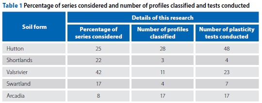
The series encountered in the study area, the percentage of the possible series considered, the number of soil profiles classified and the number of samples tested for the determination of their plasticity properties for the soils of each form are shown in Table 1. All the possible series of the five soil forms considered did not occur in the study area.
ANALYSIS
Determining engineering grading characteristics from pedological grading
Engineering grading characteristics
The grading characteristics used as criteria for the classification of a specific soil horizon for engineering purposes according to the USCS (USAEWES 1960) and the AASHTO systems (HRB 1945) include the following:
■ Masses of the fractions finer than 2.0 mm, 0.425 mm and 0.075 mm (by mass) (P2.0 mm, P0.425 mm and P0.075 mm), respectively.
■ Alan Hazen's Coefficient of Uniformity (Cu) (Taylor 1948) and the Coefficient of Curvature (Cc).
Grading data incorporated in the Land Type memoirs
Grading data, determined by the physical analysis of a soil horizon for series identification purposes and presented in the format used in the Land Type memoirs cannot be used directly to classify a soil in accordance with either of the engineering classification systems above. This is due to the following:
■ The method of particle-size analysis used by the Institute for Soil, Climate and Water to establish the grading data for inclusion in the Land Type memoirs is that described by Day (1965), with modifications discussed in Fanourakis (1999). This method differs from methods employed by laboratories performing grading analyses on soil samples for engineering classification purposes. These differences include the adoption of sedimentation principles (instead of sieve analysis) to determine the grading of the fraction finer than 0.02 mm and 0.075 mm for pedological and engineering purposes, respectively. Furthermore, the pedological method prescribes procedures for the removal of organic matter (by oxidation with 30% H2O2) and destroying of carbonates (with 2 mol/l HCl).
■ The pedological soil separate size limits do not correspond to those used to determine the engineering grading characteristics.
■ The masses of the pedological soil separates are expressed as a percentage of the mass of the fraction finer than 2.0 mm and not as a percentage of the mass of the total sample as is done for engineering purposes.
Method used for the determination of pedological grading data
The physical analyses of the soil samples included in this project to obtain those grading characteristics necessary for series identification in accordance with the South African Binomial Classification System (MacVicar et al 1977) were performed as described by Day (1965), with modifications as discussed in Fanourakis (1999).
To determine the particle-size distribution of the fraction finer than 0.053 mm, the hydrometer method was used in this project whilst the pipette method is employed by the Institute for Soil, Climate and Water (LTSS 2021). Since Day (1965) specifies both methods as alternatives, it seems reasonable to assume that the results obtained for this project would essentially be the same as would have been obtained by the Institute for Soil, Climate and Water on the same samples (LTSS 2021).
Procedure developed to estimate engineering grading characteristics from pedological data
A computer program to calculate values for the grading characteristics which are used for the classification of a soil for engineering purposes from pedological grading data as recorded in the Land Type memoirs was written in BASIC (Beginner's All-purpose Symbolic Instruction Code) computer programming language. A listing of the program, as well as the linear interpolation-based procedure followed, is given in Fanourakis (1999).
The methods used by commercial laboratories for determining the engineering grading characteristics of a soil differ from the method used by laboratories to determine the grading characteristics of a soil for pedological purposes (Fanourakis 1999).
Hence, nine identical specimens of five soil types, representative of the range of soil types sampled, were submitted to nine commercial engineering soils laboratories for the determination of their engineering grading characteristics. The grading analyses determined by the different laboratories and details on the test methods and dispersing agents used by each of the laboratories are included in Fanourakis (1999).
Table 2 lists in parallel, for each soil type, the mean value of each grading characteristic (P2.0 mm, P0.425 mm, P0.075 mm) determined by the nine commercial engineering laboratories, on the one hand, and the corresponding characteristics estimated from pedological data using the program developed, on the other.
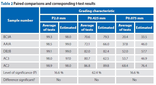
The paired values were compared and the null hypothesis assumed. The five per cent significance level was adopted.
As a result of the fact that any significant departures from the null hypothesis in either of two directions (increase or decrease) were important, the two-tailed t-test was applied to the paired comparisons for each grading characteristic to establish the level of significance. If the null hypothesis is true, the critical t-value will follow a t-distribution with (n-1) degrees of freedom. The significance levels (P) which are the probabilities of differences of such magnitudes arising by chance, as determined by each of the two-tailed t-tests, are given in Table 2.
Referring to the levels of significance (P), it is evident that the difference between the paired values for each grading characteristic is not significant. The value of the lowest level of significance established (16.6%) resulted from the t-tests performed on paired values for the five soil types, in the case of the percentages (by mass) finer than 2 mm and 0.075 mm. These values are, however, still 11.6% higher than the level of significance (P) which would have justified the rejection of the null hypothesis. Hence, it was concluded for each of the three grading characteristics that the difference between the population means of each pair of values was not significant and that the data was consistent with the null hypothesis.
Nevertheless, the magnitude of the differences between the paired values would not have resulted in the allocation of a different engineering soil classification group symbol, regardless of whether the laboratory or computer-estimated values were used (provided that no plasticity was exhibited by the soil, and the allocation of a group symbol was dependent only on grading characteristics).
As the engineering grading characteristics were estimated from the pedological grading characteristics at a statistically significant level, engineering grading characteristics for the remaining samples in the study area were not determined but were instead estimated from the pedological grading characteristics. It also appeared reasonable to assume that the above procedure is valid for determining engineering grading characteristics of other soil types and possibly any soil type from its pedo-logical grading characteristics.
Regarding the Cu and Cc - values of D10 and D3o could only be established from grading data, determined by the commercial laboratories, in the case of only one (BC3A) of the five soil types tested (in the case of the other four soil types, Dw and D30 were less than 0.002 mm). Hence, on the basis of one sample, the degree of confidence with which Cu and Cc can be estimated from the pedological data could not be determined statistically. However, practically, the Cu and Cc values may be required for classification according to the USCS, in the case of only two (GW and SW) of the 15 possible groups comprising the system. These are not required for classification according to the AASHTO system.
Determining plasticity characteristics from the soil series
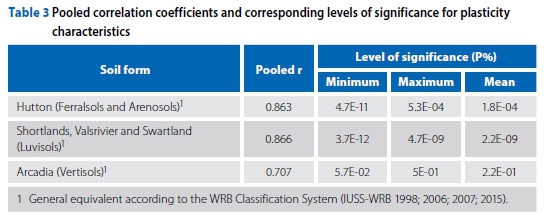
Fanourakis (2012) established relationships for determining the engineering plasticity characteristics - namely liquid limit (LL), plasticity index (PI) and linear shrinkage (LS) - of soils deriving from a range of pedological classes of the South African Binomial System (after MacVicar et al 1977) from their physical and chemical properties which are determined for pedological classification purposes. More specifically, in the case of each soil form considered, each of the plasticity properties (LL, PI and LS) was correlated with the amount of magnesium present in the clay-size portion of the fraction of the sample finer than 0.425 mm.
For each soil group, Fisher's Z-transformation technique was used to combine independent correlation coefficients, which are significant at the five per cent probability level, in order to obtain an estimate of the average (pooled) correlation coefficient. This procedure took into account each correlation coefficient and the corresponding number of sets of values on which it was based.
Significance tests were carried out for each relationship established using the Student's t-distribution (Gosset 1908) to determine the probability that the correlation coefficient could have arisen by chance in a sample of the size dealt with. All the relationships established for estimating the plasticity characteristics of the soils were highly significant (P < 1%). These relationships are represented and discussed in detail in Fanourakis (2012).
The pooled correlation coefficients and corresponding levels of significance are summarised in Table 3. The grouping of the Shortlands, Valsrivier and Swartland soil forms is justified in Fanourakis (2012).
THE MATHEMATICAL MODEL
Components of the model
Structure of the model
A flow diagram illustrating the general structure of the model is shown in Figure 1.
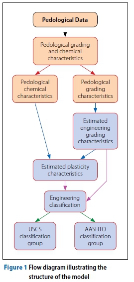
Pedological input data
The pedological data, which is the input data, consists of the following:
■ The soil form
■ The quantitative grading characteristics of the soil sample as given for pedologi-cal purposes
■ The exchangeable magnesium (in me %), included in the quantitative chemical characteristics of the soil as given for pedological purposes.
Engineering soil properties output
Engineering grading characteristics The engineering grading characteristics of the soil sample are estimated from the pedological grading characteristics.
Plasticity characteristics In the case of each soil form, the LL, PI and LS are estimated using the highly significant mathematical relationships obtained between these properties and the physical and chemical soil properties such as the percentage finer than 0.425 mm (P0.425 mm), the clay content (P0.002 mm) and the quantity of the exchangeable magnesium cations (in me %) (Fanourakis 2012).
Fanourakis (2012) proposed that soils of the Hutton form with a clay content less than 12% are automatically designated as non-plastic. This 12% was the average clay content of 18 Hutton soils that were non-plastic and had clay contents ranging from 6% to 18%. In this paper it is proposed that the relationships pertaining to soils of the Hutton soil form should not be applied to soils with a clay content equal to or less than 18%, as these were not included in the establishment of the relationships. The estimation of plasticity characteristics from pedological data is discussed in detail in Fanourakis (2012).
These relationships to determine plasticity characteristics were applied using data which fell within the range on which the relevant relationships were established.
Engineering classification of soils
The soil is classified according to the two most commonly employed engineering soil classification systems, namely the USCS (USAEWES 1960) and the AASHTO system (HRB 1945).
Limitations of the model
This research entailed the investigation of soils occurring in a particular area. Not all the series encompassed by the forms investigated occur in the study area. Furthermore, the behaviour of soils of the series researched which have a chemical and mineralogical composition differing from that of the soils included in the research is not known. Hence, the plasticity relationships could not be applied in such cases.
VERIFICATION OF THE MODEL
Verification sources
The model was verified by being applied using pedological data to determine the engineering properties of soils in the study area.
In addition, the model was verified using data from a pedological and geo-technical report pertaining to an area in Lephalale (formerly Ellisras), located approximately 190 km from the study area.
Verification using data from the study area
Data used
The USCS and AASHTO classifications for each of the samples tested as part of this research project were determined by using:
■ the estimated engineering grading characteristics and the plasticity results obtained from standard engineering laboratory tests, on those samples, and
■ the engineering grading and plasticity characteristics by applying the model to the quantitative physical and chemical pedological data of the same samples.
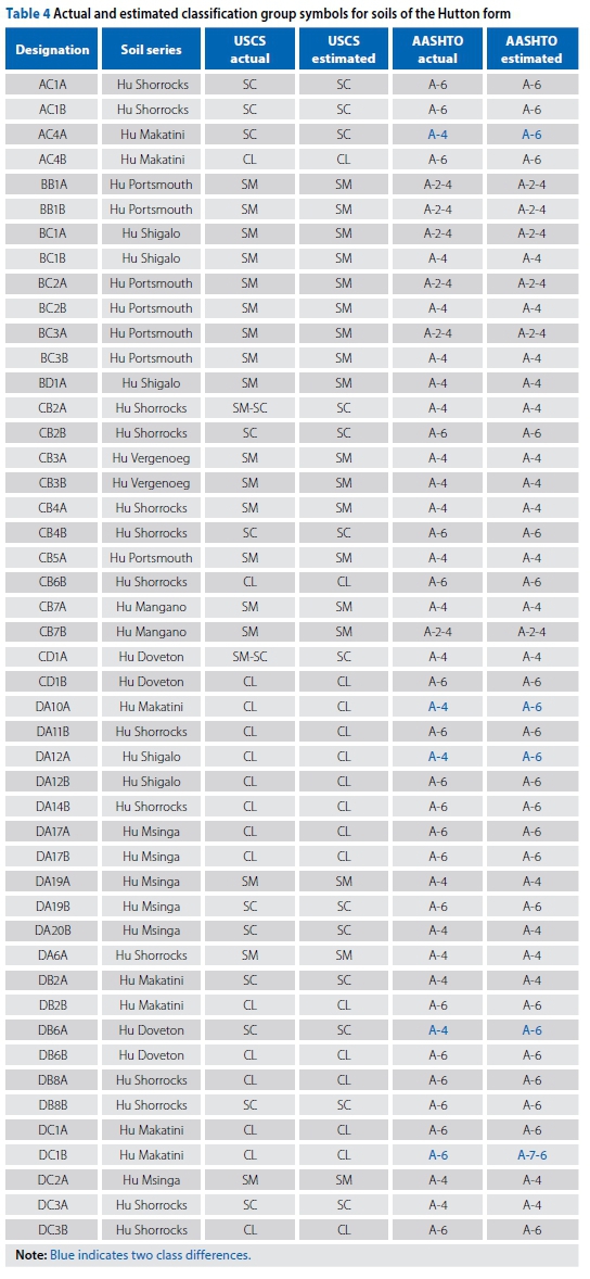
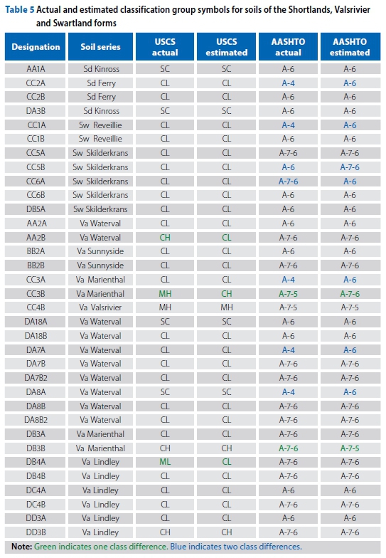
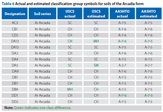
One soil of the Hutton form and three of the Arcadia form were excluded, as they had physico-chemical properties outside the ranges pertaining to the relevant plastic relationships. The engineering soil classification group symbols mentioned above are shown in parallel, for the 95 soils of the different forms included in the study area, in Tables 4 to 6.
Results and discussion
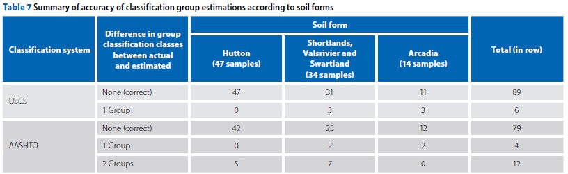
Table 7 shows the a summary of soil form specific results of the accuracy of the estimated classification group symbols, according to the AASHTO and USCS systems, for the soils considered.
Considering the soils of all the series included in this research, a total of six of the 95 (6%) estimated USCS group symbols differed from actual symbols of the same soils by one group. No samples differed by more than one group. In cases where either the actual or estimated symbol was included in the other, this was considered not to be different. For example, the actual and estimated USCS symbols assigned to sample CB2A were SM-SC and SC, respectively.
In the case of the AASHTO classification, the estimated and actual group symbols of a total of 16 samples (17%) differed. Four of these differed by one class and 12 differed by two classes. In this analysis, the classes of A-7-5 and A-7-6 were considered to be different classes (although they comprise the A-7 class). The four soils which differed by one class were such soils. None of the soils differed by more than two classes. Furthermore, nine of the 12 soils that differed by two classes had actual and estimated groups of A-4 and A-6, defined by a PI of 10 max or 11 min, respectively. A total of four soils differed in subclass within the A-7 class (A-7-5/A-7-6).
Verification using soil data from areas outside the study area
Area considered
The validity of the model was also tested using soil data of the Lephalale area in the Limpopo Province which, according to the map of the pedology of southern Africa, after Harmse and Hattingh (1985), generally comprises similar soils to those researched but is located approximately 190 km northwest of the study area.
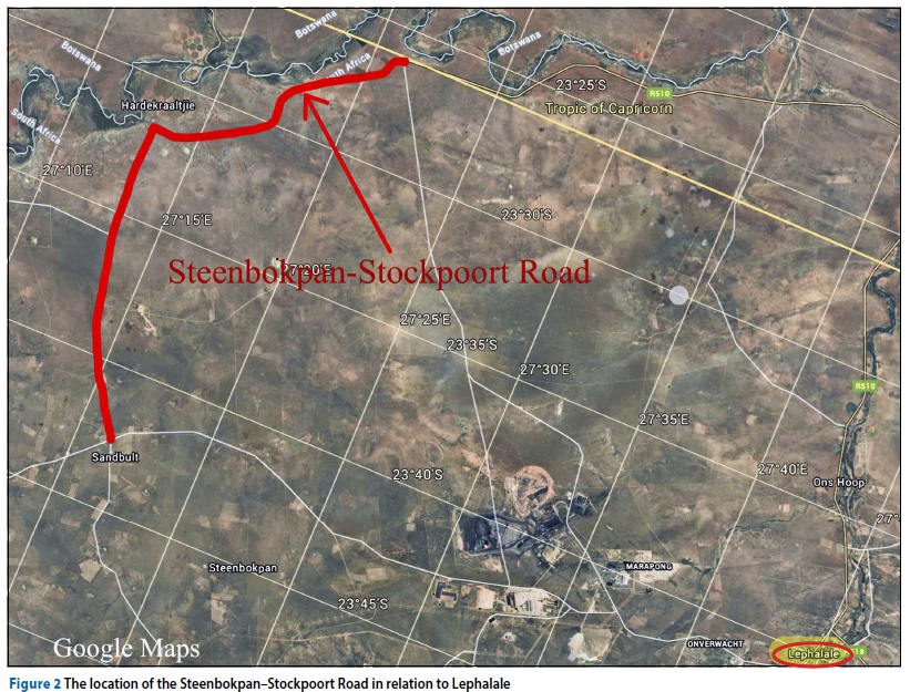
Pedological and engineering data of the soils occurring along an approximately 38 km section of the SteenbokpanStockpoort Road (Road 175 which is situated in this area) were obtained from the Pedological Research Institute and the (former) Roads Department of the Transvaal Provincial Administration (TPA 1987), respectively. The location of this road in relation to Lephalale is shown in Figure 2.
Data obtained
The pedological data acquired comprised six soil profiles which were recorded alongside or very close to this section of the road as part of a pedological mapping exercise (conducted to a 1:50 000 scale), as well as the pedological physical and chemical data of the soils constituting these profiles (IPR 1989).
The engineering data comprised the pavement and gravel pit design sheets which were compiled using data gathered as part of a detailed investigation conducted along this section of the road. The pavement design sheets, which were drafted using a standard form, included data on the colour, depth, grading, plasticity, bearing strength (CBR) and AASHTO classification of the natural soils occurring on the road centreline at 200 m intervals. The gravel pit design sheets included data such as the material description, profile depth, grading characteristics, plasticity characteristics, AASHTO classification and bearing strength characteristics of the material occurring in nine trial pits excavated in each proposed borrow area (TPA 1987). The USCS classification groups were not given.
The area adjacent to this road is characterised by red soils of the Hutton and Bainsvlei soil forms and yellow-brown soils of the Clovelly and Avalon forms. Soils of the Valsrivier, Swartland and Arcadia forms which were included in the research are generally located more than 2 km from the road.
Application of the model
The model was used to determine the AASHTO classification of the soils represented by the six profiles along the road route from the pedological data of these soils.
Of the soils comprising the six profiles, only the properties of the Hutton soils had been researched for the purposes of establishing the model. However, the Bainsvlei soil profile consists of a Hutton soil profile underlain by a soft plinthic (ferruginised) horizon. Furthermore, the Clovelly profile, like the Hutton profile, has an intact structure and clays present are mainly of the 1:1 kaolinitic type, but is yellow in colour and not red as in the case with the Hutton soil profile. The Avalon soil profile consists of a Clovelly soil profile which is underlain by a soft plinthic horizon. In other words, the Hutton, Bainsvlei, Clovelly and Avalon soil forms are all characterised by Apedal B horizons.
Therefore, although the properties of the soils of the Bainsvlei, Avalon and Clovelly forms were not investigated as part of the project on which the model is based, the section of the model applicable to the soils of the Hutton form was applied using pedological data of the Clovelly form soils and soils overlying the soft plinthic horizon of the Bainsvlei and Avalon forms to establish whether the engineering properties of these soils would be the same as those of a Hutton soil with an identical physical and chemical composition.
Discussion and results
Subgrade properties
The AASHTO classification groups determined for the horizons in each profile (estimated) using the model, on the one hand, and determined as part of the detailed centreline engineering survey at the appropriate chainages on the other, are given in Table 8.
With reference to Table 8, the profile depths according to the pedological and engineering profiles differ.
Nevertheless, as indicated in Table 8, the estimated and determined AASHTO classification group symbols are essentially the same at each chainage. Where, for example in the case of HK 6 and HK 19, two groups were given as the actual, these included the estimated group (A-2-4). Similarly, in the case of SP 4, where two groups were given as the estimated, these included the actual group.
Gravel pits
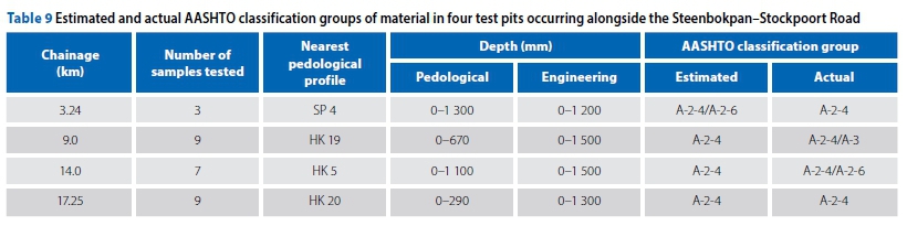
Thirteen potential borrow pits located along the road route were investigated as part of the detailed engineering survey. Nine test pits were excavated in each of the 13 potential borrow areas. The profiles in all of these borrow areas comprised calcrete or red and/or brown soil which is underlain by calcrete or ferricrete (TPA 1987). In view of the fact that the pedological test pits profiled were located such that the range of soils occurring in the area was represented by these profiles, none of the pedological test pits were specifically placed in any of the borrow pits. However, four of the six pedological test pits profiled alongside the road were situated within a distance of 0.6 km and 2.0 km from borrow pits.
The AASHTO classification groups in Table 9 were determined by applying the model to pedological data obtained from the four pedological profiles in the vicinity of the potential borrow areas, and the corresponding values were determined on samples from the test pits in the four potential borrow areas by conventional engineering test procedures.
A comparison of the data in Table 9 revealed that the actual and estimated AASHTO classification groups, in the two parallel lists, were essentially the same. Where, for example in the case of HK 19 and HK 5, two groups were given as the actual, these included the estimated group. Similarly, in the case of SP 4, where two groups were given as the estimated, these included the actual group. In any case, the minor differences could probably be attributed to the fact that the plasticity properties of the soils in the four pedological profiles might have differed somewhat from those of the soils in the test pits since the pedological profiles and test pits were not identically located.
It is also important to note that, although the model was developed from test results of, amongst others, red soils of the Hutton form but not from test results of red soils of the Bainsvlei form or yellow-brown soils of the Clovelly and Avalon forms (which were not included in the research), the mathematical model appears to be valid for these soils as well. This is probably because all the above-mentioned soil forms have Apedal B horizons.
However, it must be noted that, in the model, soils of the Hutton form with a clay content less than 18% are designated as nonplastic. Therefore, since the soils in the area traversed by this road generally have a low clay content, the validity of the plasticity section of the model could not be confirmed.
CONCLUSIONS
The model developed and its verification
A mathematical model was successfully developed that enabled the determination of engineering grading and plasticity characteristics, as well as classification (USCS and AASHTO) from pedological data. This model was verified using data from the study area, as well as data from an area located approximately 190 km from the study area.
Verification using data from the study area
The engineering grading characteristics of soils from the study area were determined to a statistically significant degree of accuracy (using the five per cent level of significance).
The plasticity characteristics of soils from the study area were statistically significantly estimated from the physico-chemical data of soils, for a range of pedological groups. All the relationships established for estimating the plasticity characteristics of the soils of the Hutton form (Ferralsols and Arenosols according to the WRB Soil Classification System), Arcadia form (Vertisols according to the WRB system) and Shortlands, Valsrivier and Swartland forms (Luvisols according to the WRB system) were highly significant (P < 1%) (Fanourakis 2012).
Regarding the estimated USCS and AASHTO classification group symbols of soils from the study area, of the 95 soils included in the project, in total, 12% of the estimated classification group symbols differed from the actual classification group symbols. Furthermore, only 6% of the classification groups differed by two groups. However, only in 2% of the soils (CC3B and DA13) did the estimated and actual classification group symbols, according to both the above engineering soil classification systems, differ. However, if the estimated Pls of CC3B and DA13 were 10% lower and 1% higher, respectively, the estimated and actual USCS symbols would have been the same. From all the above results it can be concluded that the estimated engineering classification group symbols, determined by applying the model, provide a sufficiently accurate indication of the probable engineering behaviour of these soils.
Verification using data from outside the study area
The estimated AASHTO classification groups of soils of the Hutton, Bainsvlei, Clovelly and Avalon forms, which occur adjacent to a road located approximately 190 km north of the study area, were determined using physical and chemical pedological data and the section of the model pertaining to the soils of the Hutton form. These estimated classification groups did not differ significantly from the actual classification groups which were determined from soils that had been sampled from the same locations or nearby as part of a detailed engineering survey.
Application of the model and further research
The findings of this research are valid for soils of the pedological classifications investigated and their particular physical, chemical and mineralogical properties only, since the research project was intended to serve as a pilot study. The indications are that additional similar studies covering soils of the pedological classifications researched but with different chemical properties, as well as soils with other pedological classifications with varying chemical properties, could undoubtedly lead to the extension of this work and improvement of its universality.
This model is intended to assist in the supplementing of information in the reconnaissance stages of certain projects.
Finally, it is hoped that this research has succeeded in emphasising the interrelationships between pedogenesis and the engineering behaviour of soils, and in suggesting an approach for the interpretation of pedological data for engineering purposes.
REFERENCES
Calitz, F 2021. Proposed system to facilitate use of pedological information in preliminary stage geotechnical investigations. PhD Thesis. Potchefstroom: North-West University. [ Links ]
Council for Geoscience 1974. Geological Series Map 2426 Thabazimbi. Scale 1:250 000. Pretoria: Government Printer. [ Links ]
Day, P R 1965. Physical and mineralogical properties, including statistics of measurement and sampling. In Black, C A, Evans, D D, White, J L, Ensminger, L E & Clark, F E (Eds.), Methods of Soil Analysis - Part 1. Madison, WI: American Society of Agronomy. [ Links ]
FAO (Food and Agriculture Organization of the United Nations) 2021. Soils Portal, Data Hub. www.fao.org/soils-portal/soil-survey/soil-classification/world-reference-base/en. [ Links ]
Fanourakis, G C 1999. Engineering soil properties from pedological data. DTech (Eng) Thesis. University of Johannesburg. [ Links ]
Fanourakis, G C 2012. Estimating soil plasticity properties from pedological data. Journal of the South African Institution of Civil Engineering, 54(2): 117-125. [ Links ]
Fanourakis, G C 2022. Utilising land type data for geotechnical investigations. Journal of the South African Institution of Civil Engineering, 64(1): 12-24. [ Links ]
Gosset, W S 1908. The probable error of a mean. Biometrika, 6(1): 1-25. [ Links ]
Harmse, H J Von M & Hattingh, J M 1985. The pedological profile classes. In Brink, A B A (Ed.), Engineering Geology of Southern Africa, Vol 4, 272-273. [ Links ]
HRB (Highway Research Board) 1945. The United States Bureau of Public Roads Classification System. Proceedings, 25th Annual Meeting of the HRB, Washington, DC. [ Links ]
IPR (Institute for Pedological Research) 1989. Pedological maps, profile descriptions and physical and chemical properties of the soils in the area covered by the Steenbokpan, Hardekraaljie and Stockpoort 1:50 000 Quarter Degree Sheets. Potchefstroom University for CHE. [ Links ]
IUSS-WRB (International Union of Soil Science Working Group (IUSS)-World Reference Base for Soil Resources (WRB)) 1998. A framework for international classification, correlation and communication. World Soil Resources Report No 84. Rome: Food and Agriculture Organization of the United Nations (FAO). [ Links ]
IUSS-WRB 2006. A framework for international classification, correlation and communication. World Soil Resources Report No 103. Rome: FAO. [ Links ]
IUSS-WRB 2007. World Reference Base for Soil Resources 2006. First update 2007. A framework for international classification, correlation and communication. World Soil Resources Report No 103. Rome: FAO. [ Links ]
IUSS-WRB 2015. World Reference Base for Soil Resources 2014. Update 2015. International soil classification system for naming soils and creating legends for soil maps. World Soil Resources Report No 106. Rome: FAO. [ Links ]
LTSS (Land Type Survey Staff) 2021. Land types of South Africa: Digital map (1:250 000 scale) and soil inventory databases. Pretoria: Institute for Soil, Climate and Water, Agricultural Research Council. https://www.arc.agric.za/arc-iscw/Pages/ARC-ISCW-Homepage.aspx. [ Links ]
MacVicar, C N, De Villiers, J M, Loxton, R F, Verster, E, Lambrechts, J J N, Merryweather et al 1977. Soil classification: A binomial system for South Africa. Scientific Bulletin No 390. Pretoria: Department of Agriculture Technical Services. [ Links ]
SCWG (Soil Classification Working Group) 2018. Soil classification: A natural and anthropogenic system for South Africa. Pretoria: Institute for Soil, Climate and Water, Agricultural Research Council. [ Links ] Taylor, D W 1948. Fundamentals of Soil Mechanics (13th printing, December 1963) p 9. [ Links ]
TMH 1 1986. (Technical Methods for Highways). TMH1 1986: Standard Methods of Testing Road Construction Materials, 2nd ed. Pretoria: Department of Transport. [ Links ]
TPA (Transvaal Provincial Administration) 1987. Centre line survey for the proposed Stockpoort-Steenbokpan Road (Road 175). Conducted by Van Wyk and Louw Inc for the TPA Roads Department, Job No 2420, Ellisras District, Drawing Nos PRS 87/171/1Sp, 2Sp, 106-109, 118, 120-122. [ Links ]
USAEWES (United States Army Engineer Waterways Experiment Station) 1960. The Unified Soil Classification System. Technical Memorandum No 3-357. Appendix A, Characteristics of soil groups pertaining to embankments and foundations, 1953; Appendix B, Characteristics of soil groups pertaining to roads and airfields. Vicksburg, MS: USAEWES. [ Links ]
 Correspondence:
George Fanourakis
Department of Civil Engineering Technology, University of Johannesburg
PO Box 17011, Doornfontein, 2028, South Africa
T: +27 11 559 6416; E: georgef@uj.ac.za

PROF GEORGE FANOURAKIS (FICE, FSAICE) is Associate Professor in the Department of Civil Engineering Technology at the (now) University of Johannesburg, which he joined around 28 years ago after leaving the employ of Jones and Wagener (Pty) Ltd Consulting Engineers. He holds the degrees of MSc(Eng) and DTech(Eng), and is a Chartered Civil Engineer and Fellow of the Institution of Civil Engineers (UK). He is also a Fellow of the South African Institution of Civil Engineering (SAICE), an Honorary Fellow (and Past-President) of the Institute of Professional Engineering Technologists (IPET) and Member of the Soil Science Society of Southern Africa. His professional participation further includes membership of three South African Bureau of Standards (SABS) committees, membership of COM9:Dissemination of Knowledge of the fib (fédération internationale du béton), and membership of TC306 (Geo-Engineering Education) of the International Society of Soil Mechanics and Geotechnical Engineering (ISSMGE).

