


Services on Demand
Article
 English (pdf)
 Article in xml format
 Article references
Indicators

Related links
-
 Cited by Google
 -
 Similars in Google
Share

 Permalink
Journal of the South African Institution of Civil Engineering
On-line version ISSN 2309-8775
Print version ISSN 1021-2019
J. S. Afr. Inst. Civ. Eng. vol.62 n.4 Midrand Dec. 2020
http://dx.doi.org/10.17159/2309-8775/2020/v62n4a1
TECHNICAL PAPER
Geotechnical characterisation and back analysis of a landslide in marl deposit: A case study of Algiers Sahel (coast), Algeria
M Filali; A Nechnech; J de Rosa; H Gadouri; B Meziani
ABSTRACT
The purposeof this study isto present the results of geotechnical investigations and landslide analysis in a marl deposit at the Sahel (coast) of Algiers in northern Algeria, where many landslides take place in the Plaisancian marls, particularly following rainfall periods each year, causing severe damage to infrastructures and buildings. The physico-mechanical characteristics of the soils obtained from three different sites (El-Achour, Daly-Brahim and Ouled-Fayet) were analysed to identify the mechanism of these landslides. In the study, the laboratory test results providing grain-size distribution, Atterberg limits, water content, shear strength, and compressibility were analysed. The findings showed that, although the soils were characterised by slightly higher plasticity at Ouled-Fayet, they were generally homogeneous in the studied sites. The upper soils, generally weathered, exhibited low shear strength parameters, which are lower than the undisturbed formation beneath. The stability analysis based on limit equilibrium methods (LEM) showed the significant influence of pore water pressures on slope stability, suggesting that the weathered soils are prone to instability processes due to the effect of long rainy periods.
Keywords: Plaisancian marls, landslides, weathering, physicomechanical properties, limit equilibrium methods
INTRODUCTION
Landslides are considered one of the most destructive natural hazards in the world, accounting for approximately 9% of the natural disasters that occurred worldwide during the 1990s (Yilmaz 2009), causing large numbers of casualties and huge economic losses in the mountainous areas of the world (Dai et al 2002), Landslides are very common in northern Algeria, where they are triggered by a combination of several factors linked to the site geology, land morphology, hydrology and climate, as well as antropic activities (Bahar & Djerbal 2016), Studies have revealed that several landslides occurred in many regions, such as Constantine (Benaissa et al 1989; Lafifi et al 2009; Bougdal et al 2013), Medea (Medjnoun 2014), and Kabylie (Machane et al 2009; Bouaziz & Melbouci 2015; Meziani et al 2018), Algiers is one of the cities affected by this geological hazard which causes severe damage to structures and infrastructure, After the independence of Algeria (in 1962), rapid urbanisation took place, which extended to marginal lands southwest of the Sahel (coast) of Algiers once the areas became more favourable for construction, El-Achour, Daly-Brahim, Ouled-Fayet and Sidi-Abdellah are among the new urbanisation areas which are affected by landslides.
The superficial or deep instability processes (rotational or complex) were mainly observed in the Plaisancian marls and sandy clays providing the transition between the Plaisancian and molassic Astien facies (Aymé 1965), Some studies showed that the landslide triggers in most cases were linked to rainfall or to antropic actions which cause modification of the soil stress state (Bahar & Djerbal 2016), The study of Bièvre et al (2016), on the other hand, purported that the variations in the soil strength parameters due to weathering may also be one of the important causes of instability.
This study focused on the Plaisancian marls that outcrop in a large area of urban expansion in the southwest Algiers Sahel (coast) where an important deterioration of the mechanical properties of the marls is one of the main causes of the slope instability processes, This study analysed the results of laboratory tests (grain-size distribution, index properties, direct shear, and compressibility tests) obtained from inspections of an existing database of soil laboratories and companies, In order to conduct a deep investigation, the study examined several samples from the subsoil of El-Achour (site A), Daly-Brahim (site B) and Ouled-Fayet (site C), Other tests were also carried out to evaluate both the residual strength parameters and the susceptibility to progressive failure, Finally, a back-analysis based on limit equilibrium methods (LEM) was performed to examine the role of soil mechanical deterioration due to weathering, and the role of pore water pressures on the slope stability of the study area.
Study area
The study area is located on thick deposits of Plaisancian marls in the southwest of the Algiers Sahel (coast) (Figure 1). The geological formation of the Plaisancian marls outcropping in the Algiers Sahel, with a thickness of more than 200 m, is a homogeneous massive deposit of sedimentary rocks resulting from organic and mineral sediments in a shallow marine environment (Bouteldja et al 1997), The marls are covered by an Astien series of sandy clay and sandstone, which form the plateaus (a high plain or tableland) of El-Achour and Ouled-Fayet to the northeast that have been subjected to intense erosion (Meghraoui 1988). The Sahel is a succession of hills formed by Plaisancian marls with a slope inclination varying from 5% to 30% (Derriche & Cheikh-Lounis 2004). The topography resulted from the post-Astien tectonics, which caused the uplift of the Atlas Mountains and the formation of the Sahel anticline and the depression of Mitidja (Royer et al 1961; Aymé 1956). It should be noted that the landslides, characterised by wavy morphology (Bougdal 2007), occur in the weathered marl horizons of which the thickness varies with the degree of weathering, reaching about 8 m in depth, even at a slope inclination greater than 10%, The degree of weathering affects the strength parameters and therefore the slope stability of the Plaisancian marls.
METHODOLOGY
The methodological approach adopted by the study included the different phases as summarised below.
In the first phase, several technical reports were collected from different public administrations, soil laboratories and companies. These reports were analysed to obtain physical and mechanical data on the soil of El-Achour (site A), Daly-Brahim (site B), and Ouled-Fayet (site C) (Figure 2).

In the second phase, the landslide area was selected in Daly Brahim (site B) to support the collected data, In this area, some samples were extracted for further laboratory investigation conducted essentially to evaluate the grain-size distribution, the Atterberg limits, compressibility, and the residual strength parameters.
In the final stage, slope stability analyses were performed for site B to evaluate the effect of both strength parameters and pore water pressure on the slope safety factor.
Data collection method
Data for the study was collected from the technical reports obtained from the archives of local authorities, soil laboratories and companies. Thus, 80 reports and additional field data were analysed. This data provided 156 laboratory test results including grain-size distribution, index proprieties, shear-strength parameters, compressibility and swelling properties.
During this study, some samples from Daly Brahim were extracted and nine laboratory tests were performed to support collected data, by providing additional information on grain-size distribution, Atterberg limits, compressibility, and shear-strength parameters,
Laboratory tests
Laboratory tests were performed on 11 soil samples from site B, Eight disturbed samples were taken on the scarp of shallow landslides between 0,5 m and 1 m depths and three undisturbed soil samples were taken at depths of about 5, 12 and 27 m.
Laboratory tests were performed according to the AFNOR standards (French Standardization Association), Grain-size distribution was evaluated by mixed sieve-sedimentation analysis, as described in NFP 94-056 and NFP 94-057, and the Atterberg limits were measured using the procedure described in NFP 94-051
The volume-change behaviour was evaluated by oedometer tests on the material taken from different depths according to XP P94-090-1, The shear test results collected from reports were carried out according to NF P-071-1, at a shear rate of 0,016 mm/min, which is lower than the maximum shear rate suggested by the standard (vmax = 125/t100 mm/min, with t100 = end of consolidation time) for all the considered samples, All tests were performed on the samples at three different levels of normal stress.
Slope stability analysis
The slope stability analyses were performed for site B to examine the effect of both strength parameters and pore water pressures on the slope safety factor. The analyses were performed using the computer programme SLOPE/W (by Geoslope International Ltd) based on LEM, Moreover, the Morgenstern-Price method (1965) was used and a slip surface reaching the base of the weathered soil was analysed. Pore-water pressure distribution at the basis of stability analysis was evaluated by the SEEP/W programme (by Geoslope International Ltd) and different hydraulic boundary conditions were considered.
RESULTS AND DISCUSSION
The stratigraphy of the three investigated sites was reconstructed on the basis of the material extracted from 22 boreholes (locations indicated in Figure 2), The analysis shows that the weathered marls close to the ground surface are greenish-yellow mottled. The weathered horizon thickness reaches to about 8 m; beneath this depth, the undisturbed marls are generally very consistent and hard. Figure 3 shows a scheme of the typical soil stratigraphy.

Physical characteristics and index properties
The grain-size distribution curves (Figure 4) show that the considered soils are fine-grained in all three sites, with more than 70% dry weight composed of particles smaller than 80 μm. The clay fraction is important and can reach about 59%, Derriche and Cheikh-Lounis (2004) observed that the shallow weathered marls can contain a grain-size component coarser than those of the deep marls.

They claim that such coarser components fill the deep shrinkage cracks formed through the weathered marls, The curves in Figure 4 show that particles coarser than 0,8-1 mm were found also in the deeper unweathered soil, The origin of such particles was not investigated in this work.
Figure 5 depicts the results of the variation in dry unit weight (yd), water content (w), saturation degree (Sr), liquid limit (LL), plasticity index (PI), and calcium carbonate content (CaCOs) with depth, As Figure 5 depicts, the dry unit weight of the weathered layer of sites A and B increases from about 14 kN/m3 close to the ground surface to about 19 kN/m3 at a depth of about 8 m, below which, in the underlying undisturbed formation, it is almost constant, It is worth noting that some samples were extracted in May, and others between October and March of the following year, Irrespective of the month of sampling, the weathered marls were saturated (Sr = 100%) or almost saturated at the investigated depths. This result has important consequences for the response of pore water to rain, as shown in the section of slope stability analysis. The water content decreases from about 30% close the ground surface to an average of about 15% in the undisturbed formation, Site C, in contrast, has a dry unit weight and water content almost constant along the verticals, and close to the minimum and maximum values, respectively, of the corresponding parameters of the other two sites, The higher water content and lower dry unit weight of site C are probably due to the presence of more expansive clay minerals. In fact, the Atterberg liquid limits of site C are generally higher than the other two sites (Figures 5 and 6), whereas the clay fractions are similar. This site is actually known for its high swelling potential (Medjnoun 2014), associated with the predominance of illite-montmorillonite minerals (Bougdal 2007).

The experimental results indicate that a high clay fraction is dominant in all three sites, The clay soils, weathered from the parent rock mass, contribute to landslide occurrence due to their chemical and physical properties (Yalcin 2007), The intense rainfall in the region probably causes osmotic phenomena of water adsorption which leads to the mechanical deterioration of the shallow layers of weathered marls (Picarelli & Di Maio 2010), with important implications for the stability of the considered slopes (Di Maio et al 2015; Di Maio et al 2017).
Compressibility
Figure 7 shows the e-loga'ncurves obtained for undisturbed samples, which were extracted from both the weathered and unweathered formations of site A (Figure 7a), site B (Figure 7b) and Figure 7d), and site C (Figure 7c). It should be noted that the volume change behaviour was evaluated by oedometer tests on the material sampled from several different depths.
The profiles of compression index (Cc), swelling index (Cs), and over-consolidation stress (σc) are reported in Figure 8, The comparison between σcand the effective vertical field stress (σv) of the corresponding sample showed that the considered soils are over-consolidated, The over-consolidation is mainly due to the erosion of an overburden constituted by more than 100 m thick deposit of sandstones and Astien sands (Bougdal 2007), Most of the considered samples show a loss of the over-consolidation effects, whereas the deeper samples (e,g, those in Figure 7(d)) still maintain it, Figure 7(d) compares both the oedometer loading and unloading curves of the undisturbed soils (sampled from a depth of about 27 m at site B) and the curves of the same soils reconstituted at the LL.

Figure 7 indicates that the undisturbed soil is strongly over-consolidated, and its curves have an average slope very close to that of the unloading curve of the reconstituted soil, The Cc values ranging from 0,08 to 0,2 indicate that the soils have low to medium compressibility known to be a characteristic of marls and weathered marls, respectively (Carter & Bentley 2016).
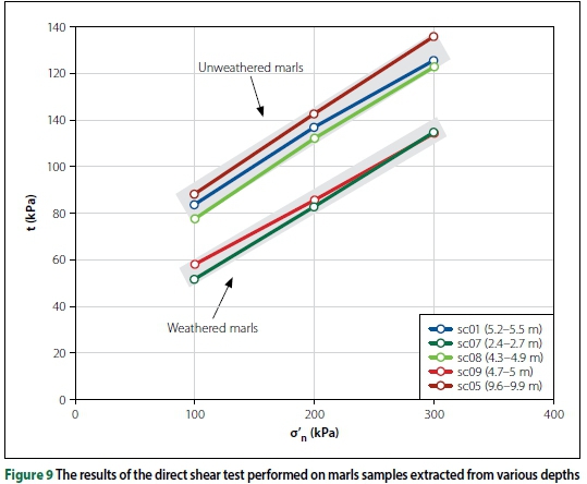
Shear strength parameters
Figure 9 illustrates the results for Daly-Brahim subsoil, The shear tests were carried out on samples of weathered marls, constituted by 60% - 70% silt and 40% - 30% clay, i,e, on the fine-grained samples of Figure 4, The tests provided average values of cohesion c' and friction angle φ' of about 20 kPa and 14°, respectively, However, beyond this depth (more than 8 m), both the average c' and φ' increase up to about 45 kPa and 16°, respectively, Figure 9 refers to undisturbed materials, thus the shear behaviour depends not only on the grain-size distribution and plasticity but also on the soil fabric and on the soil stress-strain history. The obtained failure curves, with low friction angles and relatively high cohesion intercepts, are typical of over-consolidated materials, The mechanical deterioration of the shear parameters in weathered marls is probably due to the phenomenon of weathering, On the one hand, the weathering of the marls involves physical and chemical processes which lead to strength degradation (Eberhardt et al 2005; Picarelli & Di Maio 2010), the effects of which can be evaluated by laboratory tests on intact soil samples, In the field. however, other weathering effects can occur, Shunchao and Vanapalli (2015) reported that drying and wetting cycles can induce the development of fissures and cracks, which modify the original structure of the clay, thereby decreasing the stress level and increasing both water inflow and porosity.
Besides the collected results, other experimental results were obtained from the laboratory tests conducted within the scope of this study, The shear behaviour from peak to residual shear strength was evaluated on two samples (S01 and S04) extracted from a depth of 5 m in weathered marls (S01) and from about 12 m (S04) in unweathered marls, respectively, Sample S01 was consolidated under a normal stress of 197 kPa, and was then sheared (Figure 10), The first two cycles were performed at low displacement rates (v = 5 μm/min), The following cycles were performed faster in order to obtain a complete alignment of the clay particles within a few days, At a displacement of about 40 mm, the rate was lowered to 5 μm/min again, after which additional cycles were performed to obtain the drained residual shear strength parameters, residual friction angle φ'rand residual cohesion c'r (Figure 12), The same specimen was subsequently consolidated under a higher normal stress at 297 kPa and sheared again to the residual conditions.


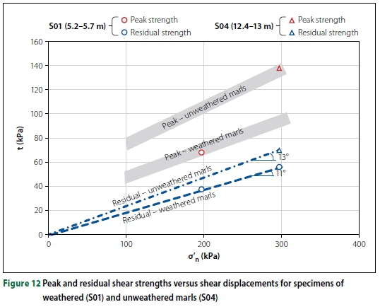
Figure 11 presents the results obtained for a specimen of sample S04 extracted from the unweathered formation, The specimen was consolidated and then sheared to the residual conditions at a rate of 5 μm/min, Figure 12 shows that the residual friction angle of weathered marls is φ'r =11°, Under the reasonable hypothesis that c'r is null, φ'rof the sample of unweathered marls is 13°, a little bit higher, probably because of the difference in grain size distribution and c,f, (Figure 4).
Both values are consistent with the presence of important percentages of clay minerals (Lupini et al 1981), The comparison between the peak strength lines and the residual ones shows the dramatic drop in strength from peak to residual, indicating the susceptibility of the soil to progressive failure.
Slope stability analysis
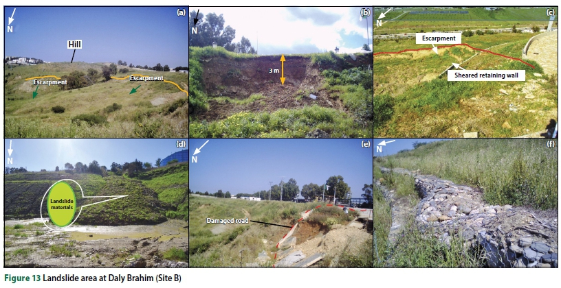
The stability analyses were performed for a slope from Daly Brahim (site B), where the instability problems mainly occur in the upper weathered marl horizons (Figure 13).
The calculations were performed with reference to the section A-A' (Figure 14a). The pore-water pressure distributions for the analyses in 2D and drained conditions were evaluated by the code SEEP/W for the domain represented in Figure 14b. Since the soils have high values of the degree of saturation and the water level recorded in some piezometers ranges from 0,3 m to 10 m depths, the soil was always studied saturated so that three different hydraulic boundary conditions were considered:
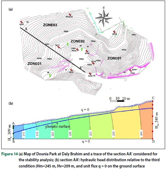
1. hydraulic head equal to the elevation of the ground points on the two vertical boundaries AB and CD, and water pressure u = 0 on the ground surface
2. hydraulic head 5 m lower than in the first case on the two vertical boundaries and null unit flux (q = 0) on the ground
3. hydraulic head 10 m lower than in the first case on the two vertical boundaries and null unit flux on the ground.
The first condition on the ground (u = 0) corresponds to continuous rain with intensity higher than the soil hydraulic conductivity, while the second condition (q = 0) corresponds to dry weather, The results of the stability analyses performed using SLOPE/W for the worst slip surface are illustrated in Figure 15a, and for the three water pressure distributions are shown in Figure 15b in terms of c' - φ' couples which provide a safety factor SF = 1, The figure shows that the strength parameters characterising the peak strength of the undisturbed, not weathered, formation are much higher than those corresponding to failure along the considered slip surface, even in the case of u = 0, In contrast, the parameters of the weathered formation are closer to those corresponding to failure, for the case of u = 0 on the ground surface (condition 1) corresponding to continuous rain with intensity higher than the vertical permeability. The values of residual friction angle φ'r(11°-13°) are equal to or even lower than the parameter that brings the slope to failure under the third hydraulic condition. It is thus reasonable to hypothesise that the real available strength parameters are intermediate between the peak and the residual ones.

As a matter of fact, the considered landslide located in site B occurred after considerable rainfall in 2011, In most cases, the infiltration of precipitation into the slide surface triggers a landslide (Eberhardt et al 2005), The investigated part of the shallow marls shows a decrease in mechanical interlock parameters. The weathering and additional water infiltration can further reduce the shear-strength parameters. The increase in pore water pressures decreases the shear strength, thus reducing the factor of safety (Bahar & Djerbal 2016, Liu & Li 2015).
CONCLUSIONS
The purpose of this study was to report the results of geotechnical investigation and landslide analyses in marl deposits, The Plaisancian marls that outcrop in the urban expansion areas in the southwest of the Algiers Sahel (coast) are often affected by slope instability processes, In order to evaluate the impact of weathering and climate on the safety factor of the slopes, back-analyses of a landslide that occurred at one of the sites were also performed. The results of the study reveal that the soils of the unstable slopes considered at EL Achour, Daly Brahim, and Ouled Fayet are fine-grained and exhibit medium to high plasticity; and the Atterberg liquid limits of Ouled Fayet soil are generally higher than those of the other two sites, The upper greenish-yellow mottled soils are weathered and generally present significantly higher water content than the undisturbed sample below. The latter is generally very consistent and hard, The thickness of the weathered horizon reaches about 8 m and the instability processes generally occur in the weathered marls. A comparison of strength parameters obtained by the laboratory tests and strength parameters obtained by back analyses shows that the most critical conditions are reached in the weathered marls during long rain periods, and the available strength parameters are intermediate between the peak and the residual ones. It is worth noting that the considered pore water pressure distributions were obtained considering steady-state hydraulic conditions, The time required to reach these conditions can be strongly influenced by the presence of cracks and fissures which act as paths of fast water flow or pressure propagation.
ACKNOWLEDGEMENTS
The authors express their sincere gratitude and appreciation to the engineers of the National Laboratory of Habitat and Construction (LNHC) who provided data and soil samples.
REFERENCES
Aymé. A 1956. Modifications recentes survenues dans le réseau hydro graph ique de la plaine de la Mitidja, Bulletin de la Société d'histoire naturelle d'Afrique du Nord, 47: 50-56. [ Links ]
Bahar. R & Djerbal, L 2016. Rainfall and human intervention-induced landslides in the north of Algeria. Proceedings, 12th International Symposium on Landslides, Naples. Italy, pp 349-354. [ Links ]
Benaissa. A. Cordary. D & Giraud. A 1989. Les mouvements de terrains dans la zone urbaine de Constantine (Algérie). Bulletin of the International Association of Engineering Geology. 40(1): 85-90. [ Links ]
Bièvre, G, Longmans. D. Goutaland. D. Pathier, E & Zumbo. V 2016. Geophysical characterisation of the lithological control on the kinematic pattern in a large clayey landslide (Avignonet. French Alps). Landslides, 13(3): 423-436. [ Links ]
Bouaziz. N & Melbouci, R 2015. Apport de la tomographic électrique dans l'étude des glissements de terrain de la grande Kabylie. Algérie. Proceedings. 33rd Meeting of the Collaborative and Cross-border Project ISA BTP (UPPA) and EUPLA (UNIZAR), and EIG (UPV). Bayonne, France, pp 27-29 [ Links ]
Bougdal, R2007. Urbanisation et mouvement de versara, dans le contexte géologique et géotechnique des bass ins nêogène dAlgèrie du Nord. PhD Thesis, Algiers, Algeria; University of Science and Technology. [ Links ]
Bougdal, R, Larriere, A, Pincent, B, Panet, M & Bentabet, A 2013. Les glissements de terrain du quartier Belouizdad, Constantine, Algérie. Bulletin of Engineering Geology and Environment, 72(2); 189-202. [ Links ]
Bouteldja, M, Neggazi. Z & Ourari, S 1997. Gonflement des marnes du Pliocene d Alger. Engineering. Proceedings. 22nd International Symposium on Engineering Geology and Environment, Athens, Greece, pp 61-64. [ Links ]
Carter, M & Bentley, S 2016. Soil Properties and their Correlation. London: Wiley. [ Links ]
Dai, F C, Lee, C F & Ngai, Y Y 2002. Landslide risk assessment and management: An overview Engineering Geology. 64(1): 65-87. [ Links ]
Derriche. Z& Cheikh-Lounis, G 2004. Geotechnical characteristics of the Plaisancian marls of Algiers. Bulletin of Engineering Geology and Environment, 63(4); 367-378. [ Links ]
Di Maio, C, Vassallo. R & Scaringi, G 2015. Residual strength and creep behaviour on the slip surface of specimens of a landslide in marine origin clay shale Influence of pore fluid composition. Landslides, 12(4); 657-667. [ Links ]
Di Maio. C. Vassallo. R. Scaringi, G, De Rosa. I, Pontolillo. D M & Grimaldi. G M 2017. Monitoring and analysis of an earth flow in tec ton i sed clay shale and study of a remedial intervention by KCl wells. Italian Geotechnical Journal (RIG). 51(3): 48-63. [ Links ]
Eberhardt, E. Turo. K & Luginbuehl. M 2005. Slope instability mechanisms in dipping interbeded conglomerates and weathered marls: The Ruf i landslides, Switzerland. Engineering Geology. 77(1-2): 35-56. [ Links ]
Lafifi, B, Darve. F, Nouaouria, M S & Guenfoud, M 2009. Utilisation du critère de stabilité de Hill en milieu non saturé pour la modélisation des glissements de terrain de la region de Constantine. Proceedings, 19th French Congress of Mechanics, Marseille, France, pp 24-28. [ Links ]
Liu, Q Q & Li, ] C 2015. Effects of water seepage on the stability of soil-slopes. Proceedings, IUTAM Symposium on the Dynamics of Extreme Events Influenced by Climate Change, Lanzhou, China, pp 29-39 [ Links ]
Lupini, J F, Skinner, A E & Vaughan, P R 1981. The drained residual strength of cohesive soils. Géotechnique, 31(2): 181 213. [ Links ]
Machane, D, Guillier, B, Chatelain, ] L et al 2009. Le séisme (Mw = 5) de Laalam (Kabylie, Algérie) du 20 Mars 2006: Prospections géologiques et géophysiques (bruitvibratoire ambiant) et correlations avec les dommages. Bulletin du Service Géologique National, 20(3): 357-373. [ Links ]
Medjnoun, A 2014. Analyse, caractérisation, prevision et modélisation du comportement des argiles gonflante PhD Thesis, Tizi Ouzou, Algeria; University of Mouloud Mameri. [ Links ]
Meghraoui, M 1988. Geologie des zones sismiques du Nord de PAlgérie; Paleo sismologie, tectonique active et synthèse sismo-tectonique. PhD Thesis, Paris, France; University of Paris VI. [ Links ]
Meziani, B, Machane, D, Bendaoud, A, Mohamedi, Y, Hallal, N& Adjiri, S 2018. Contribution des méthodes géophysiques (HVSR et Down Hole) et géotechniques dans la caractérisation du Glissement dÄomar (W Bouira, Algérie). Proceedings. 2nd International Symposium on the Geology of the Maghrebid Range and Neighbouring Regions, Sétif. Algeria, pp 53-55. [ Links ]
Picarelli, L & Di Maio, C 2010. Deterioration processes of hard clays and clay shale. Geological Society of London, Engineering Geology Special Publications, 23(1); 15-32. [ Links ]
Rover. L, Moussu, H, Aymé, J M, Aymé, A, Laffitte. R & Deleau, P 1961. Carte géologique au 1/50000 d Alger. Paper No. 21, Service de la carte géologique d Algérie. [ Links ]
Shunchao, Q & Vanapalli, K 2015. Stability analysis of an expansive clay; A case study of infiltration-induced shallow failure of an embankment in Regina, Canada. International Journal of Geohazards and Environment. 1(1): 7-19. [ Links ]
Yalcin, A 2007. The effects of clay on landslides; A case study. Applied Clay Science. 38 (1): 77-85. [ Links ]
Yilmaz. I 2009. Landslide susceptibility mapping using frequency ratio, logistic regression, artificial neural networks and their comparison; A case study from Kat landslides (Tokat, Turkey). Computer Geosciences. 35(6); 1125-1138. [ Links ]
 Correspondence:
Mira Filali
Water Environment and Geomechanics Laboratory, Civil Engineering Faculty, University of Sciences and Technology
Houari Boumediene, Algiers, Algeria
T: +213 772 47 48 34
E: m.filali@univ-dbkm.dz
Prof Ammar Nechnech
Civil Engineering Faculty, University of Science and Technology
Houari Boumediene, Algiers, Algeria
T: +213 21 24 72 24
E: nechnech_a@yahoo.fr / anechnech@usthb.dz
Dr Jacopo De Rosa
School of Engineering, University of Basilicata
Potenza, Italy
T: +097 141 1044
E: jacopo.derosa@unibas.it / derosajacopo888@gmail.com
Dr Hamid Gadouri
Earth Sciences Department, Djillali Bounaama University
Khemis Miliana
T: +213 27 72 17 94
E: hamid_gadouri2000@yahoo.fr / hamid.gadouri@univ-dbkm.dz
Dr Brahim Meziani
Earth Sciences Department, Djillali Bounaama University
Khemis Miliana, Ain Defla, Algeria
T: +213 675 323 207
E: brahim.meziani@univ-dbkm.dz

MIRA FILALI is presently a PhD student in the Civil Engineering Faculty and in the Environment, Water, Geomechanics and Structures Laboratory at the University of Sciences and Technology Houari Boumediene, Algiers. She is also an engineer at the National Polytechnic School of Algiers (ENPA), and a teacher and researcher in the Earth Sciences Department at the Djilali Bounaama University, Khemis Miliana. Her research interests focus mainly on landslides in clayey soil.

PROF AMMAR NECHNECH, who holds a doctorate from the National Polytechnic Institute of Loraine, Nancy, France, is an engineer at the National Polytechnic School of Algiers (ENPA), Algeria, and Director of the Environment, Water, Geomechanics and Structures (LEEGO) Laboratory at the Houari Boumediene University of Science and Technology (USTHB) in Algiers. He is also Dean of the Faculty of Civil Engineering at USTHB.

DR JACOPO DE ROSA is a post-doctoral research fellow at the University of Basilicata (UniBas), Italy. He received his PhD in "Engineering for Innovation and Sustainable Development" at UniBas in 2019, with a dissertation titled Ion transport from KCl wells and K+ effects on the shear strength of a clayey earthflow. His current research interests focus on the chemo-mechanical processes affecting clay behaviour, the influence of such processes on the evolution of landslides in clayey soils, and the hydro-chemo mechanics of earthflows.

DR HAMID GADOURI works in the Department of Earth Sciences at Khemis Miliana University, Algeria. He obtained his Master's degree in Geotechnical Engineering from Khemis-Miliana University in 2010, and his PhD in Construction Engineering and Geotechnical from Medea University in 2017. Currently he lectures geotechnical engineering at Khemis-Miliana University and is a researcher in the Geomaterials Laboratory at Chlef University. His research interests are in the field of chemical soil stabilisation. He also reviews papers for several journals.

DR BRAHIM MEZIANI works in the Department of Earth Sciences at Khemis Miliana University, Algeria. He received the PhD degree in Imaging and Digital Mapping in Geosciences from the University of Houari Boumediene in 2018. He worked at the National Laboratory of Habitat and Construction, and at the Centre for Research in Astronomy, Astrophysics and Geophysics for six and two years respectively. His research interests are in geology, geotechnical engineering and geophysical methods. He is the author and co-author of seven scientific articles. At present, he is a lecturer at Khemis-Miliana University.

