


Services on Demand
Article
 English (pdf)
 Article in xml format
 Article references
Indicators

Related links
-
 Cited by Google
 -
 Similars in Google
Share

 Permalink
Journal of the South African Institution of Civil Engineering
On-line version ISSN 2309-8775
Print version ISSN 1021-2019
J. S. Afr. Inst. Civ. Eng. vol.60 n.2 Midrand Jun. 2018
http://dx.doi.org/10.17159/2309-8775/2018/v60n2a1
TECHNICAL PAPER
Sinkhole and subsidence size distribution across dolomitic land in Gauteng
S Constantinou; J L van Rooy
ABSTRACT
Karst-related sinkholes and subsidences occur on areas underlain by Chuniespoort Group dolomite bedrock in the Gauteng Province, South Africa. Although dolomite land is found across several South African provinces, sinkhole and subsidence formation in Gauteng, the economic hub of South Africa, has been considerably more severe than in other provinces. Thousands of sinkhole and subsidence events have occurred in the past 50 years. Previously, data on sinkhole and subsidence occurrence was amassed separately by various consultants, companies, research institutions and state authorities. There is no legal requirement for sinkhole and subsidence events to be reported to a central authority, yet the data is crucial for future assessment of sinkhole hazards and decision-making. Information regarding the sinkhole record for Gauteng was collated to develop an inventory of the study area. Compiling a comprehensive database presented many challenges; most importantly the large volume of incomplete data that could not be retrieved. Sinkholes, and subsidence and crack events prior to the end of 2011 were considered for Gauteng. Data was organised into multi-wave frequency tables, and various aspects were then analysed. This paper deals with available dimension data (i.e. diameter and depth) across the Gauteng Province.
Keywords: dolomite, sinkhole, subsidence, Chuniespoort, Gauteng
INTRODUCTION
According to Ford and Williams (1992), sinkholes are the most diagnostic surface expression of karst landscapes and can be found extensively throughout the world (approximately 7-10% of the earth land surface has been classified as karst terrain). Karst-related sinkholes and subsidence events occur on areas underlain by dolomite ground in South Africa. Dolomite land occurs across several South African provinces, including Gauteng, Mpumalanga, Limpopo, North West and the Northern Cape. However, sinkhole formation in Gauteng Province poses a greater risk to infrastructure than in any of the other provinces to date.
Thousands of sinkhole, subsidence and crack events have occurred in the past 50 years within the Gauteng Province. According to Buttrick et al (2011), four to five million people currently work or reside on dolomite land, and these instability events have resulted in loss of life and/or damage to property when they coincide with human development. Damage to buildings and other infrastructure has been more severe on dolomite than on any other rock type in South Africa (Brink 1979; Wagener 1985), and thus far 39 people have lost their lives (Buttrick & Roux 1993).
In the past, data on sinkhole and subsidence occurrences was amassed separately in papers, research theses and databases held by various consultants, companies, research institutions and state authorities. There is currently no legal requirement for sinkhole and subsidence events to be reported to a central authority (Heath & Oosthuizen 2008). Sinkhole statistics have not been available since the work by Wolmarans (1984) and Scheming (1990), although Heath and Oosthuizen (2008) indicated in excess of 2 400 instability events in a preliminary overview of the sinkhole record for South Africa. More recent research (Richardson 2013) shows numbers are in excess of 3 000 (sinkhole/subsidence/ground crack events). Sinkhole and subsidence data is crucial for future assessment of sinkhole hazards and decision-making.
DOLOMITE AND SINKHOLE FORMATION
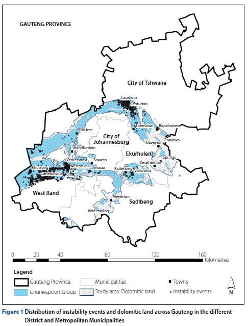
In Gauteng Province the Malmani Subgroup (Chuniespoort Group, Transvaal Supergroup) dolomites occupy a surface area of approximately 2 576 km2 (14% of Gauteng's surface area) and form two broad arches (northern and southern) around the Halfway House Granite. However, the area considered as "dolomitic land" (Bosch 2003), including areas covered by younger non-dolomitic formations but still underlain by dolomite at depth (within 60-100 m), covers an area of approximately 4 005 km2, i.e. 24% of Gauteng's surface area (see Figure 1).
The dolomite rock which occurs in the Transvaal Supergroup comprises a series of alternating bands of insoluble chert and soluble dolomite. Small amounts of iron and manganese carbonates are also commonly present (Brink & Partridge 1965). Dolomite rock possesses a system of discontinuities (fractures, joints and faults) which act as preferential solution passages for water ingress. Although dolomite rock is relatively impervious (porosity less than 0.3%) and insoluble in pure water, rainwater which has become charged with carbon dioxide in its passage through the atmosphere and the soil, flows along these discontinuities, slowly acting to dissolve the rock (Brink 1979). Eventually steep valleys are corroded within the shear zones (of faults), with dolomite rock standing as pinnacles between the corroded grykes/val-leys. The hard rock dolomite is usually covered by an upward succession of residual products (weathered dolomite, wad1, chert and residual chert) that are often overlain by younger formations or are intruded by dykes or sills (Brink 1979).
The residual mantle can be extremely irregular (Martini in Johnson et al 2006). A residual product such as wad has low strength in most cases, and is highly compressible and may be tens of metres thick. The vertical succession of these residual products normally reflects a decrease in strength and compressibility with depth. Voids are also sometimes present in the wad (De Bruyn & Bell 2001).
The mechanism of sinkhole and subsidence formation is described in detail by Jennings et al (1965) and Buttrick (1992).
They describe ground subsidence in dolo-mitic formations as taking place in one of two ways: as a gradual or caving subsidence or a rapid and catastrophic sinkhole. These events are most often caused by ingress water or lowering of the groundwater table.
SINKHOLES AND SUBSIDENCES IN THE GAUTENG PROVINCE
Numerous papers and reports have been published, and an abundance of research exists on the subject of sinkholes and investigation techniques on dolomite land in South Africa, particularly on Gauteng in which the bulk of the incidents have been reported. Historically the Far West Rand (the area from Westonaria to Carletonville) was the focus of many studies (i.e. Brink & Partridge 1965; Brink 1979; Kleywegt & Pike 1982; Wolmarans 1984) due to the frequent occurrence of sinkholes and subsidences in the 1960s and 1970s resulting from dewater-ing of several of the groundwater compartments by mining companies. The area south of Pretoria has also seen scores of sinkholes in recent history (Roux 1984; Schöning1990; De Bruyn & Trollip 2000; Heath & Oosthuizen 2008; Buttrick et al 2011), while relatively few events have been reported in the municipalities of Ekurhuleni (De Bruyn & Trollip 2000; Heath & Oosthuizen 2008), Sedibeng and the City of Johannesburg, all within the Gauteng Province.
DEVELOPMENT OF SIZE CATEGORIES
While Wolmarans (1984) indicates numerous sinkhole events prior to 1984 on the Far West Rand, dimension data was not given and size categories were not yet developed.
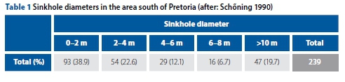
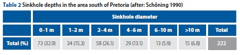
Research by Scheming (1990) analysed surface diameters and depths of over 200 sinkhole events in the area south of Pretoria (Tables 1 and 2 refer). Schening's results show that most sinkholes (>50%) had a diameter smaller than 4 m and a depth of less than 4 m.
Buttrick (1992), for the 'Method of Scenario Supposition', used a historical frequency of sinkhole and subsidence events on a type area south of Pretoria, along with geophysical surveys and borehole results, to create a method to systematically characterise dolomite hazard.
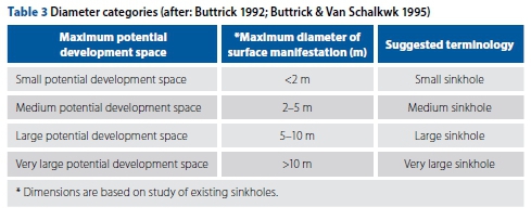
Buttrick (1992), Buttrick and Van Schalkwyk (1995), and Buttrick et al (2001) describe a number of factors which can be used to evaluate the possible formation of sinkholes, including the nature and mobilisation potential of the blanketing layer, receptacles, mobilising agents and the maximum potential development space. The maximum size sinkhole can be assessed by estimating the maximum potential development space, which is associated with a receptacle and depends on the depth and 'angle of draw' of the overburden materials. The full realisation of the potential development space depends on whether the receptacle is large enough to accommodate all the material eroded from the overburden (Buttrick 1992).
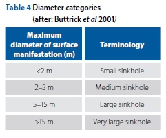
Buttrick (1992) proposed broad categories of "potential development space" and the related scale of potential maximum size sinkholes (diameter) as input into hazard assessment (Table 3). Buttrick and Van Schalkwyk (1995) later amended the broad categories, as shown in Table 4.
Heath and Oosthuizen (2008) analysed sinkhole dimensions (based on limited records) for the area south of Pretoria, and concluded that the largest proportion (29%) of sinkholes in this area has a diameter range of 5-15 m, most (>50%) are shown to be less than 15 m in diameter.
Another recent assessment using sinkhole size data involved the design of the Gautrain Rapid Rail Link (Gautrain), which passes through Centurion (south of Pretoria) and across approximately 15 km of dolomitic ground. As the alignment could not avoid the dolomitic ground, the potential sinkhole size that could occur had to be designed for to accommodate a sudden loss of support. A study (Sartain et al 2011) of the frequency of sinkhole occurrence with a diameter >15 m was undertaken and a database of sinkholes in the Centurion region was compiled (some 287 sinkholes). The diameter distribution was established. It was concluded that the most appropriate sinkhole diameter to design for was 15 m; this gave a tolerable risk with 95% confidence.
METHODOLOGY
The study collated all available data on sinkholes and subsidences in Gauteng in an attempt to establish a size distribution. The data collection process included review of reports and historical maps held at the Council for Geoscience (CGS), databases compiled by CGS, and supplied to the CGS by various consultants, companies and state authorities, various research theses, topographic maps (1:50 000) covering dolomitic areas, published during 1984, and aerial photographs covering the study areas viewed on a Geographic Information System (GIS). A typical data point may be recorded as a sinkhole or subsidence, with various descriptive information on the event noted. A large number of the data points are incomplete, with one or more of the parameters related to an event missing. Therefore the sample number used in the analysis of diameter or depth data is limited to points with complete information.
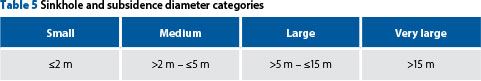
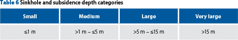
Sinkhole diameter is a very important factor, as land use and design decisions are made according to the expected size of such an event, within the engineering geology industry in South Africa. The size distribution was analysed according to the size categories proposed by Buttrick et al (2001) in Table 4; however, it was necessary to be more specific in terms of defining the start and end of each category when assigning occurrences to a specific size category. The categories shown in Table 5 were used in terms of diameter to avoid overlap in categories. Depth categories were previously suggested by Schening (1990); however, a modification of Schening's depth categories and Buttrick's diameter categories was used (Table 6), in that the depth categories have not been described in terms of small, medium or large, etc, as the diameters have.
RESULTS AND INTERPRETATION
Over 2 600 defined sinkhole or subsidence events were compiled as part of the inventory. However, very limited data sets had complete information with regard to diameter and depth of events (i.e. approximately 40% and 30% respectively).
Sinkhole diameters
Considering the available sinkhole diameter data across the municipalities of the West Rand, City of Tshwane and Ekurhuleni, where almost all (99%) of the data originates, the dominant size range is between 5 m and 15 m diameter overall, and based on the available data (n = 996), 77% of the sinkholes have a diameter of 15 m or less.
With respect to available sinkhole diameters for each municipality, the following was shown (refer to Table 5, Graph 1 and Figures 2-4):
■ >60% of sinkholes in the West Rand are large to very large
■ >60% of sinkholes in Tshwane (Pretoria) are medium to large
■ >70% of sinkholes in Ekurhuleni are small to medium.
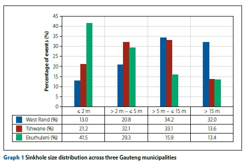
The above may give some indication of the development space that can generally be expected in each area. For example, the West Rand is notorious for very large sinkholes and typically the depth to dolomite bedrock can reach very great depths. Areas in the West Rand are also covered by younger deposits. The depth to bedrock in the Tshwane region is typically intermediate to great, while areas in Ekurhuleni are known for shallow dolomite bedrock (except in places covered by thick Karoo sediments, where dewatering has led to very large events). The other factors indicated by Buttrick (1992), Buttrick and Van Schalkwyk (1995) and Buttrick et al (2001), i.e. nature of the blanketing layer, also play a role.
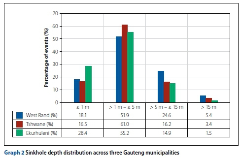
Sinkhole depths
Bearing in mind that the available sinkhole depth data across the municipalities of the West Rand, City of Tshwane and Ekurhuleni is very limited and is typically estimated by the recorder rather than measured, in general, and based on the available data (n = 821), 95% of the sinkholes have a depth of 15 m or less.
With respect to sinkhole depth for each municipality (Graph 2) most events (>50%) in all three regions are less than or equal to 5 m deep. However, some very deep sinkholes are known on the West Rand.
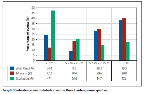
Subsidence diameters and depths
In view of the available subsidence dimension data across the municipalities of the West Rand, City of Tshwane and Ekurhuleni, subsidences are generally large to very large (refer to Table 5 and Figures 2-4). Based on the available data set (n = 210), >60% of the subsidences have a diameter of 15 m or less (Graph 3).
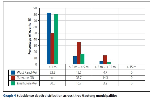
Only a quarter of the recorded subsidence occurrences have depth information recorded. Considering the available data (n = 122), 75 % of the subsidence events are 1 m or less in depth and almost all (94%) are 5 m or less in depth (Graph 4).
CONCLUSION
The main objective was to compile historical and current dolomite instability event data for Gauteng Province, and to develop an inventory to be used in statistical analysis to investigate the size distribution of sinkholes and subsidences across three municipalities and for future research.
A large amount of the available data is incomplete and therefore useable sample numbers differ. Dimension data is sometimes estimated and in most cases is also recorded after a period of time following the event, and therefore may indicate a larger size event than that which initially occurred, due to sidewall collapse. Therefore some large events reported may be overestimated in size and some small events may not have been reported if they lacked severity.
Size categories modified from Scheming (1990) and Buttrick et al (2001) were used in considering sinkhole and subsidence size and depth distributions. Based on the available sinkhole diameter data, the dominant diameter size is between 5 m and 15 m diameter overall, with 77% of the sinkholes having a diameter of 15 m or less.
Dominant diameter ranges differ across the three municipalities considered (West Rand, City of Tshwane and Ekurhuleni).
Sinkhole depth information is very limited. Overall, 95% of the sinkholes recorded are less than or equal to 15 m in depth. With respect to sinkhole depth for each municipality, most events (>50%) in all regions are 5 m or less deep. However, some very deep sinkholes are known to have occurred under special conditions.
Subsidences are generally large to very large in diameter and 5 m or less in depth.
RECOMMENDATIONS
A sinkhole database is an ongoing, continuously updated system, and results of analyses may change significantly depending on the current available data set.
It is imperative to have as complete a database as possible. The database used during this research had missing data, which could not be retrieved or updated, and therefore the available data may not be truly representative. It is important that accurate and thorough inventorisation is undertaken in future, and it should also become mandatory to report such events to a centralised organisation. Sinkhole and subsidence data is crucial for the future assessment of sinkhole hazards and decision-making. The sinkhole record, and especially the potential size of events, need to be considered for foundation designs and must be based on sound data sets per region.
ACKNOWLEDGEMENTS
The support of the Council for Geoscience to undertake the work described in this paper is acknowledged with thanks. Also thanks to all the consultants, companies and state authorities that submit data to the CGS database.
REFERENCES
Bosch, P J 2003. Map of dolomitic hazardous land in Gauteng. Unpublished map by the Council for Geoscience, Pretoria. [ Links ]
Brink, A B A 1979. Engineering Geology of Southern Africa, Vol 1. Silverton, Pretoria: Building Publications. [ Links ]
Brink, A B A & Partridge, T C 1965. Transvaal karst - Some considerations of development and morphology, with special reference to sinkhole and subsidences on the Far West Rand. South. African Geographical Journal, Vol XLVII, December. [ Links ]
Buttrick, D B 1992. Characterization and appropriate development on sites on dolomite. Unpublished PhD thesis, University of Pretoria, Pretoria. [ Links ]
Buttrick, D B & Roux, P 1993. The safety of high-density informal settlements on the dolomites of South Africa. In Beck, B F (Ed.). Proceedings, Applied Karst Geology. Balkema: Rotterdam,pp 291-294. [ Links ]
Buttrick, D B & Van Schalkwyk A 1995. The method of scenario supposition for stability evaluation of sites on dolomitic land in South Africa. Journal of the South Africa Institution of Civil Engineers, 37(4): 4-14. [ Links ]
Buttrick, D B, Van Schalkwyk, A, Kleywegt, R J & Watermeyer, R B 2001. Proposed method for dolomite land hazard and risk assessment in South Africa. Journal of the South African Institution of Civil Engineering, 43(2): 27-36. [ Links ]
Buttrick, D B, Trollip, N Y G, Watermeyer, R B, Pieterse, N D & Gerber, A G 2011. A performance-based approach to dolomite risk management. Environmental Earth Sciences, 64(4): 1127-1138. [ Links ]
De Bruyn, I A & Bell, F G 2001. The occurrence of sinkholes and subsidence depressions in the Far West Rand and Gauteng Province, South Africa, and their engineering applications. Environmental & Engineering Geoscience, VII(3): 281-295. [ Links ]
De Bruyn, I & Trollip, T 2000. Ground subsidence problems associated with dolomitic land, Gauteng Province, South Africa. Proceedings, Sixth International Symposium on Land Subsidence, Vol 1, 24-29 September, Ravenna, Italy. [ Links ]
Ford, D C & Williams, P W 1992. Karst Geomorphology and Hydrology. New York: Chapman and Hall. [ Links ]
Heath, G J & Oosthuizen, A C 2008. A preliminary overview of the sinkhole record of South Africa. Paper presented at SAICE Conference on Problem Soils in South Africa, 3-4 November, Midrand. [ Links ]
Jennings, J E, Brink, A B A, Louw, A, Gowan, G D 1965. Sinkholes and subsidences in the Transvaal dolomite of South Arica. Proceedings, Sixth International Conference on Soil Mechanics and Foundation Engineering, 5-15 September, Montreal, pp 51-54. [ Links ]
Johnson, M R, Anhausser, C R & Thomas, R J (Eds) 2006. The Geology of South Africa. Johannesburg: Geological Society of South Africa /Pretoria: Council for Geoscience. [ Links ]
Kleywegt, R J & Pike, D R 1982. Surface subsidence and sinkholes caused by lowering of the dolomitic water table on the far West Rand Gold Field of South Africa. Annals of the Geological Survey of South Africa, 16: 77-105. [ Links ]
Martini, J E J 2006. Karst in caves. In: Johnson, M R, Anhausser, C R & Thomas, R J (Eds) 2006. The Geology of South Africa. Johannesburg: Geological Society of South Africa/Pretoria: Council for Geoscience, pp 661-668. [ Links ]
Richardson, S 2013. Sinkhole & subsidence record in the Chuniespoort Group Dolomite, Gauteng, South Africa. Unpublished MSc dissertation. University of Pretoria. [ Links ]
Roux, P 1984. Geotegniese ondersoek vir dorpsontwikkeling in dolomietgebiede. Unpublished DSc thesis. University of Pretoria. [ Links ]
Sartain, N, Mian, J, O'Riordan, N & Storry, R 2011. Case study on the assessment of sinkhole risk for the development of infrastructure over karstic ground. In: Vogt, N, Schuppener B, Straub, D & Bráu, G (Eds). Proceedings, Third International Symposium on Geotechnical Safety and Risk (ISGSR 2011), 2-3 June, Karlsruhe: Bundesanstalt für Wasserbau. [ Links ]
Schöming, W L 1990. Verspreiding van sinkgate en versakkings in die dolomietgebiede suid van Pretoria. Unpublished MSc dissertation, University of Pretoria. [ Links ]
Wagener, F von M 1985. Dolomites. Problems of soils in South Africa - State of the art. The Civil Engineer in South Africa, July: 395-407. [ Links ]
Wolmarans, J F 1984. Ontwatering van die dolomietgebied aan die verre Wes Rand: Gebeure in perspektief. Unpublished DSc thesis, University of Pretoria. [ Links ]
 Correspondence:
Samantha Constantinou
T: +27 31 266 2479
E: samco850@gmail.com
Prof Louis Van Rooy
Department of Geology University of Pretoria Private Bag X20 Hatfield 0028 South Africa
T: +27 12 420 2023
E: louis.vanrooy@up.ac.za

SAMANTHA CONSTANTINOU (PrSciNat) worked for the Council for Geoscience for nine years after graduating from the University of KwaZulu-Natal with a BSc Honours in Engineering and Environmental Geology. She spent the last eight of these years predominantly working on dolomite stability report reviews for housing and infrastructure development, and on dolomite research, having received her Master's in 2013 from the University of Pretoria. She is registered with SACNASP (South African Council for Natural Scientific Professions) and is a member of SAIEG (South African Institute for Engineering and Environmental Geologists). She also sat on committees for the SANS 1936: 2017 document revisions.

PROF LOUIS VAN ROOY (PrSciNat) started lecturing in the Department of Geology, University of Pretoria, in 1985 and obtained his PhD in Engineering Geology in 1992. He lectures to pre- and postgraduate mining and civil engineering, hydrogeology and engineering geology students. His research interests include durability of basic igneous rocks for use in civil engineering construction, problem soils, safe development on dolomite land, and rock engineering. He has supervised or co-supervised more than 25 MSc and PhD students, and is author or co-author of more than 30 papers in journals and conference proceedings. He serves on the councils of both SAIEG and IAEG (International Association for Engineering Geology) and is the IAEG's Vice-President for Africa.
1 Wad: an insoluble and highly compressible material that consists of a porous mixture of Mn and Fe oxides left behind after dissolution of dolomite and has a cellular structure inherited from the texture of the rock. Wad forms a favourable horizon for cave or cavity formation. It has a high mobilisation potential, and groundwater seepage causes subsurface erosion. The highly compressible nature also supports the development of shallow but wide subsidences (Martini 2006).

