


Serviços Personalizados
Artigo
 Inglês (pdf)
 Artigo em XML
 Referências do artigo
Indicadores

Links relacionados
-
 Citado por Google
 -
 Similares em Google
Compartilhar

 Permalink
Journal of the South African Institution of Civil Engineering
versão On-line ISSN 2309-8775
versão impressa ISSN 1021-2019
J. S. Afr. Inst. Civ. Eng. vol.56 no.2 Midrand Ago. 2014
TECHNICAL PAPER
The issue of personal safety on dolomite: Update of a probability-based evaluation with respect to single-storey residential houses
H A D Kirsten; G J Heath; I S Venter; A C Oosthuizen
Correspondence
ABSTRACT
Sinkholes may be treated as a chance phenomenon of which the likelihood of occurrence is a key parameter in determining their effect on public safety in the development of dolomite land. However, determining the likelihood of the occurrence of sinkholes remains a complex if not evasive problem in view of the sparsely populated datasets available at present.
Three approaches to determining the likelihood of sinkhole occurrence that were developed over a period of time are reviewed and comparatively evaluated. The geological time-based return periods postulated for a residential infiltration regime in the third approach is applied to determine the maximum allowable population densities for a single-storey residential house development as an update of a previous paper on the problem.
The maximum population densities based on this updated approach were found to be one and a half to three times larger than those previously considered to be allowable for Inherent Hazard Classes 1, 2 and 3. This relaxation on the historically established empirical rules on population density is considered by the authors to better represent observations in recent years.
Keywords: dolomite, sinkhole, risk, hazard, coincidence, probability, single houses
INTRODUCTION
Sinkholes are treated in the paper as a chance phenomenon of which the likelihood of occurrence is a key parameter in determining their effect on public safety in the development on dolomite land. To determine the likelihood of sinkhole occurrence, however, remains a complex if not evasive problem.
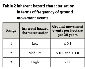
Two approaches were pursued by Kirsten et al (2009) to determine the likelihood of sinkhole occurrence. The first approach was based on the severity of the hazard in terms of anecdotal ground movement intensity as proposed by Buttrick: et al (2001). Buttrick et al defined the inherent hazard of a site as the chance for a certain size of sinkhole to occur in a dolomite residuum as a result of a misuse of the site in terms of water management and proposed land usages. Sinkholes are considered to be mostly circular in shape and their size is accordingly determined by diameter. Buttrick et al expressed the hazard in three anecdotal categories, namely low, medium and high, and defined a matrix of eight Inherent Hazard Classes and four sinkhole sizes of varying likelihood of occurrence as shown in Table 1. Sinkhole size is referred to in the literature in terms of intervals as given in this table, which is retained in the paper for the sake of compatibility. The categories low, medium and high are defined in Table 2 after Buttrick et al (2001) in terms of the number of sinkholes that can potentially form per hectare in a period of twenty years.
The second approach was based on estimates of the likelihood of sinkhole occurrence in the eight hazard classes and four sinkhole sizes by professionals familiar with dolomite ground, since the anecdotal categories (low, medium and high) were restricted in range. The results from the two approaches to determine the likelihood of sinkhole occurrence were not entirely satisfactory and could not be applied to the situation in a city centre where the infiltration regime is entirely different from those in the two approaches considered. Infiltration regime denotes the particular characteristics of the water-bearing services, measures to control stormwater, landscaping and irrigation provisions, occurrence of impermeable pavements and dewatering protocols that apply to a particular use of the land.
A third approach has since been developed which consistently applies to the entire spectrum of infiltration regimes that are usually encountered in the development of dolomite land. This third approach comprises sinkhole return periods assigned by the authors and Dr R J Kleywegt for natural, residential and city centre infiltration regimes in terms of the underlying dolomite ground profile, and a longstanding empirical understanding of dolomite land stability and the effectiveness of remedial interventions. The considerable differences in infiltration regime for natural land, residential development and city centres had previously not been considered.
The longstanding empirical understanding of dolomite land stability and the effectiveness of precautionary interventions refer to the experiential guidelines on residential land development densities that the authors and Dr Kleywegt had come to accept as reliable measures over many years of observation. Historically, population densities of 300, 200, 75, 100, 20, 0 and 0 people per hectare on residential land in the eight hazard classes respectively had become an established guideline. However, over the past ten to twenty years it has become necessary to consider much higher population densities, as presented further on in the paper.
The purpose of this paper is, firstly, to compare and evaluate the different determinations of sinkhole frequency of occurrence, and secondly, to demonstrate how the geological time-based return periods for a residential infiltration regime may be applied to determine population densities for single-storey residential house developments as an update to Kirsten et al (2009). A further objective is to present an improved method of calculation that has since been developed for this purpose.
The sinkhole return periods for a natural infiltration regime were assigned in terms of the lengths of time over which geological processes may extend, which in this instance could be a million years or more. The sinkhole return periods for residential and city centre infiltration regimes were then assigned relative to those for natural infiltration regimes in terms of engineering geological judgement of the comparative differences in infiltration potential.
Treating sinkholes as a chance phenomenon is subject to qualification. Sinkholes occur invariably as a result of untoward ingress of water into the ground or untoward abstraction of water that is already in the ground. Owing to the presence of water and wastewater reticulation infrastructure that leak and act as the trigger, sinkholes are located at or not very distant from water-bearing services. Strictly speaking, sinkholes are therefore not a chance phenomenon, although it could be argued that the causative leakages or abstractions of water due to human action or inaction are chance phenomena. Because of this, only one sinkhole occurs at a time in a particular neighbourhood or stretch of land, as waterbearing services tend to leak at isolated locations. A related aspect is that the causes of a sinkhole in a residential township and the sinkhole itself are generally repaired soon after it has occurred. More than one sinkhole therefore does not occur in principle in the same neighbourhood over a very long period of time. These qualifications have a bearing on the mathematical modelling of sinkhole occurrence as presented in this paper.
RETURN PERIOD BASED ON INTENSITY OF GROUND MOVEMENT EVENTS GIVEN BY BUTTRICK et al
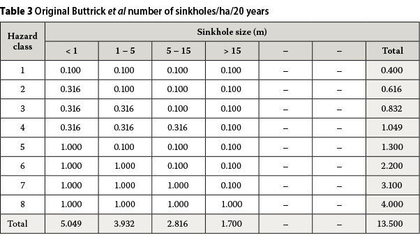
The first approach presented by Kirsten et al (2009) to determine the likelihood of sinkhole occurrence was based on an interpretation of the class-size distribution for sinkhole occurrence given by Buttrick et al (2001) as shown in Tables 1 and 2. This involved adoption of a geometric series of values of 0.1, 0.3162 and 1.0 for the three ranges as given in Table 2. The common ratio of the geometric series is equal to 10(0.1)05 = 3.162. Substituting the values 0.1, 0.3162 and 1.0 for the descriptors low, medium and high in Table 1, enables the number of sinkholes per hectare per 20-year period of time to be presented as shown in Table 3. The term inherent hazard in Tables 1 and 3 and throughout the paper indicates potential hazard. It so happens that low inherent hazard represents an acceptable level of hazard in terms of SANS 2012:1936. The purpose of precautionary measures according to this standard is to reduce the medium and high levels of inherent hazard to a low level of inherent hazard on an engineering judgemental basis.
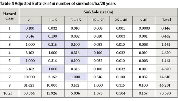
The distribution in Table 3 was adjusted and expanded with regard to Inherent Hazard Class and sinkhole size in terms of engineering judgement as shown in Table 4. The values highlighted in light blue correspond to those published by Buttrick et al (2001). The two larger size ranges were added as systematic extensions of the class-size distributions.
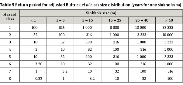
The sinkhole return period was determined, as shown in Table 5, as the quotient of 10 ha-yr and the frequencies of ground movement events given in Table 4. If A denotes the area in hectares, Q the number of potential sinkholes of a particular size in a particular Inherent Hazard Class, and N the number of years in which the potential sinkholes occur, the return period for the sinkholes, T, is by definition given by AN/Q. Adopting a conversion factor of AN = 10 ha-yr instead of 20 ha-yr as originally proposed by Buttrick et al (2001), ensured longer return periods, which enabled allowable population densities to be determined that compared better with the historically accepted population densities for single-storey dwelling houses. The comparison with the historically accepted population densities of 300, 200, 75, 100, 20, 0, 0 and 0 people per hectare for the eight Inherent Hazard Classes was, however, not entirely satisfactory. This gave rise to further developments as presented below.
RETURN PERIOD BASED ON EXPERIENTIAL JUDGEMENT OF SINKHOLE FREQUENCY
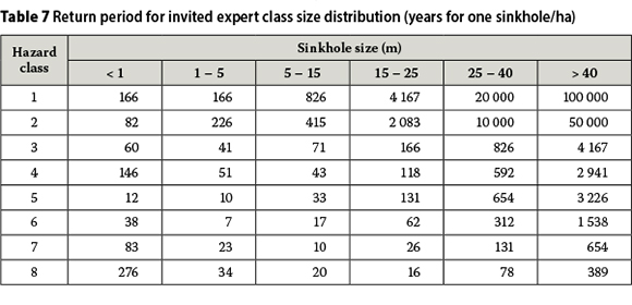
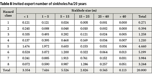
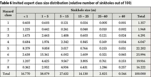
The second approach pursued by Kirsten et al (2009) to determine the likelihood of sinkhole occurrence was based on estimates of the relative potential occurrence of sinkholes in terms of sinkhole size and Inherent Hazard Class by engineering geologists familiar with sinkhole occurrence in dolomite land, as shown in Table 6. The participating engineering geologists were requested to assign the relative numbers of potential sinkholes for the different size intervals and inherent hazard classes out of a total of 100. The sinkhole return period was determined by substituting the relative number of sinkholes Q from Table 6 in the expression AN/Q = 100/Q as shown in Table 7. A conversion factor of 100 ha-yr resulted in return periods that enabled allowable population densities to be determined which optimally compared with the historically acceptable population densities for single-storey residential houses of 300, 200, 75, 100, 20, 0, 0 and 0 people per hectare for the eight Inherent Hazard Classes respectively. The number of sinkholes per hectare per 20 years for the invited expert class-size distribution was obtained by substituting the return period T from Table 7 in the expression Q = AN/T = 20/T as shown in Table 8, which is required for comparative purposes later in the paper.
RETURN PERIOD DIRECTLY ASSIGNED IN TERMS OF DOLOMITE GROUND PROFILE AND GEOLOGICAL TIME
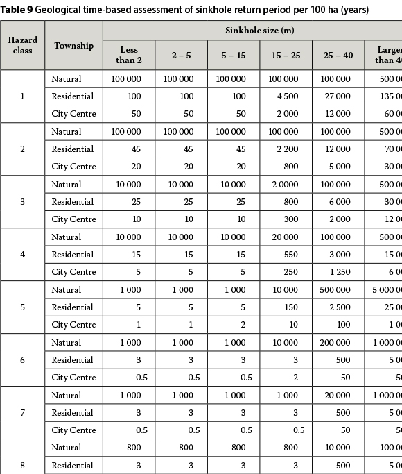
Based on experience, the authors and Dr Kleywegt assigned potential sinkhole return periods per 100 hectares for three comparative regimes of infiltration, namely natural, residential and city centre, as shown in Table 9 as a further development. The assignments represented the perceived fundamental differences between the infiltration regimes and were based on a fundamental sense of geological time and a fundamental knowledge of the geological profile of dolomite ground. The return periods for particular infiltration regimes in general do not vary for the smaller sinkhole sizes, and significantly increase for the larger sinkhole sizes. Smoothly increasing return periods with sinkhole size would have been artificial. The return periods shown were rather selected to represent large-scale phenomena, which is all that can be done in terms of current knowledge. The return periods for the residential infiltration regime were adjusted to result in maximum population densities of 800, 400, 150, 100, 30, 0, 0 and 0 people per hectare for the eight Inherent Hazard Classes respectively, as determined later in this paper. As submitted further on, these population densities were considered by the authors as permissible instead of the corresponding historically acceptable densities of 300, 200, 75, 100, 20, 0, 0 and 0 people per hectare.
COMPARISON OF ALTERNATIVE SINKHOLE FREQUENCIES
The numbers of sinkholes per hectare per 20 years corresponding to the return periods for the three infiltration regimes were obtained by substituting the return periods, T, for 100 ha from Table 9 in the expression Q = AN/T = (1/100)20/T = 0.2/T as given in Tables 10, 11 and 12 respectively. The overall numbers of sinkholes per hectare per 20 years given in Tables 3, 4, 8, 10, 11 and 12 are summarised in Table 13. The column and row totals in these tables are non-weighted arithmetic totals as a standard means of evaluating and communicating the frequency of sinkholes of all sizes in large tracts of dolomite land that may comprise any number of Inherent Hazard Classes.
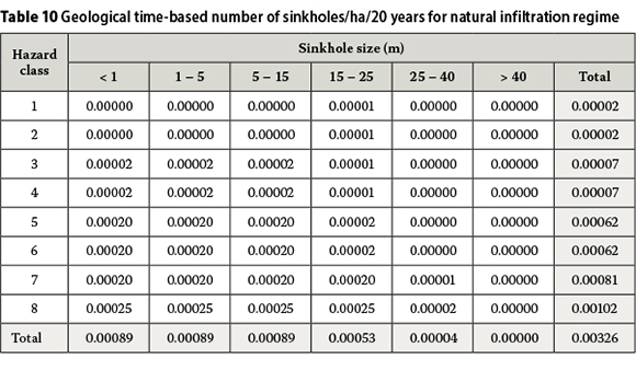
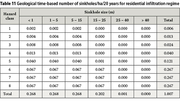
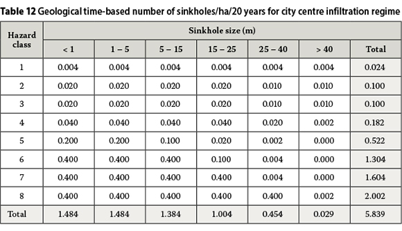
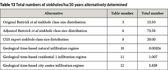
The overall numbers of sinkholes in Tables 3, 4 and 8 are comparable in order of magnitude. The differences between these cases are mainly due to differences in Inherent Hazard Classes 5, 6, 7 and 8, because the contributions to the overall numbers of sinkholes principally derive from these classes. The main contributions to the overall numbers of sinkholes in Tables 10, 11 and 12 also derive from Inherent Hazard Classes 5, 6, 7 and 8.
The progression in the overall numbers of sinkholes of 0.00326, 1.007 and 5.839 in Tables 10, 11 and 12 respectively is expected for the three infiltration regimes. However, the last two numbers, 1.007 and 5.839, are low compared to the overall totals in Tables 3, 4 and 8. This is partly due to the fact that the associated return periods in Tables 3, 4 and 8 were based on worst-case postulations with regard to water ingress and infiltration compared to the return periods in Tables 10, 11 and 12 which are effectively based on water ingress and infiltration relative to geological time.
The overall number of 1.007 sinkholes per hectare per 20 years for the geological time-based evaluation of the return periods for sinkholes in a residential infiltration regime in Table 11 in principle agrees with the longstanding experience of the authors on a considerable number of residential townships on dolomite. The veracity of the overall number of 5.839 sinkholes per hectare per 20 years for the city centre infiltration regime in Table 12 cannot yet be adjudged. Centurion City, as the only city centre on dolomite in South Africa, provides a limited database, apart from the fact that, in terms of the observations of the authors over a long period of time, it is estimated that the water-bearing services in such an infiltration regime would take thirty to forty years to deteriorate sufficiently to give rise to the accelerated formation of sinkholes.
BASIC PROBABILITY CONCEPTS
The relevant basic probability concepts may be summarised as follows from Kirsten et al (2009a).
Probability of occurrence
An event of recurrence interval T years, i.e. a T-year event, is an event of such magnitude that the average time between events of larger magnitude is T years. This length of time is also referred to as the return period. The events considered in the paper refer to sinkholes in intervals of increasing diameter. Reference to a T-year event is therefore with regard to the occurrence of a size of sinkhole in a particular interval.
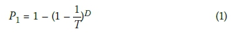
Let D denote the lifetime of a residential development. The probability, P1, that a T-year event will be exceeded at least once in the lifetime of the development is given by Expression 1. It is not necessary to consider the occurrence of more than one sinkhole in a neighbourhood, because of the way in which sinkholes occur and are repaired, as explained in the Introduction. A lifetime is defined as 70 years.
The return periods per hectare, T14, for the geological time-based residential infiltration regime given in Table 14 were obtained by substituting the return periods for 100 ha, T9, from Table 9 in the expression T14 = N/[(1/100)N/T9] = 100T9.

Probability of coincidence
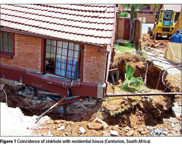
Sinkholes in principle affect houses as shown in Figure 1. A sinkhole is considered to affect a house if the house is located anywhere within the perimeter of the sinkhole, as shown in Figure 2.
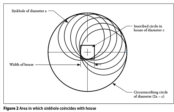
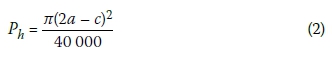
Let a denote the diameter of the sinkhole and c the diameter of the inscribed circle to the house as shown in Figure 2. The house would therefore be affected by the sinkhole if the house falls anywhere in a circle of diameter (2a-c) as shown in the figure, and the probability of coincidence would be Ph given by Expression 2:
For a residential development in which the floor area of a house is 120 m2, the diameter of the inscribed circle is of the order of 10 m. Expression [2] does not apply to sinkholes less than 10 m in diameter. The following power function in terms of sinkhole diameter a may be fitted to Expression [2] for values for 10 m < a < 50 m and a value for c = 10 m. The correlation coefficient for the fitted function is very close to 100%.
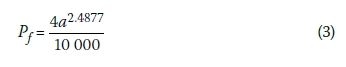
For sinkholes less than 10 m in diameter, the area of the house affected by the sinkhole is equal to that of the sinkhole. As a result, Expression [3] applies to sinkholes less than 10 m in diameter, i.e. it applies to all sinkholes from zero to 50 m in diameter.
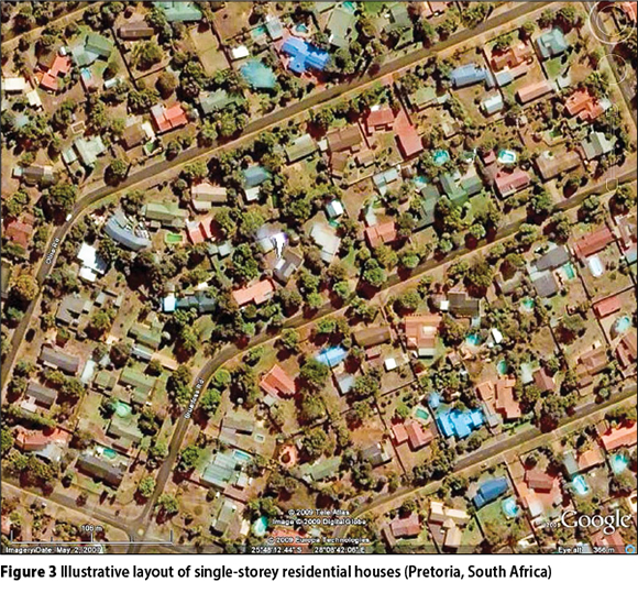
A representative layout of a township consisting of single-storey residential houses is shown in Figure 3. Consider a typical layout of single-storey houses as shown in Figure 4. Let U denote the number of houses per hectare. Every house in a particular area has a probability of being affected by a sinkhole as given in Expression [3]. The probability, P2, that any of the houses would be affected by a sinkhole is therefore given by Expression [4] since only one sinkhole occurs in general in a neighbourhood and may occur anywhere in the neighbourhood:
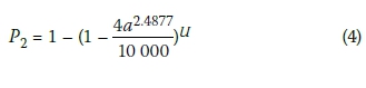
Expression [4] is not dependent on the distribution of the houses or their separation from one another. The potential number of fatal injuries is determined by the number of houses affected by a sinkhole, and that will depend on the size of the houses, their separation from one another and the size of the sinkhole.
Probabilities of additional dependent events
The following mutually dependent events have to occur in addition to sinkhole formation and coincidence with the house to cause fatal personal injury:
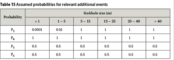
■ P3 Probability of building collapsing when affected by a sinkhole
■ P4 Probability of building occupied when affected by a sinkhole
■ P5 Probability of occupants at home when affected by a sinkhole
■ P6 Probability or relative number of fatal injuries of occupants of house when affected by a sinkhole to provide for the case in which not all the occupants are fatally injured
Values for these probabilities may be assumed for single-storey dwelling houses in terms of engineering judgement as given in Table 15 for a range of sinkhole sizes. The values shown for P3 and P4 are considered to be realistic. P4 enables long-term occupation of the building to be separately accounted from P5 that enables shorter absences during the day or night to be considered. The values for P5 represent the situation for the occupants at home for 12 out of 24 hours per day, which is realistic. The values for the probability of fatal injury, P6, may be somewhat conservative, especially for the smaller sizes of sinkhole, but no reliable statistics are available.
Threshold levels for fatal injury
Lifetime probability is defined as the probable unit number of times that a detrimental event could occur during the life of the person affected. A natural lifetime is on average 70 years. Parameter D in Expression [1] is therefore taken as 70.
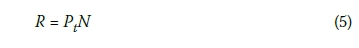
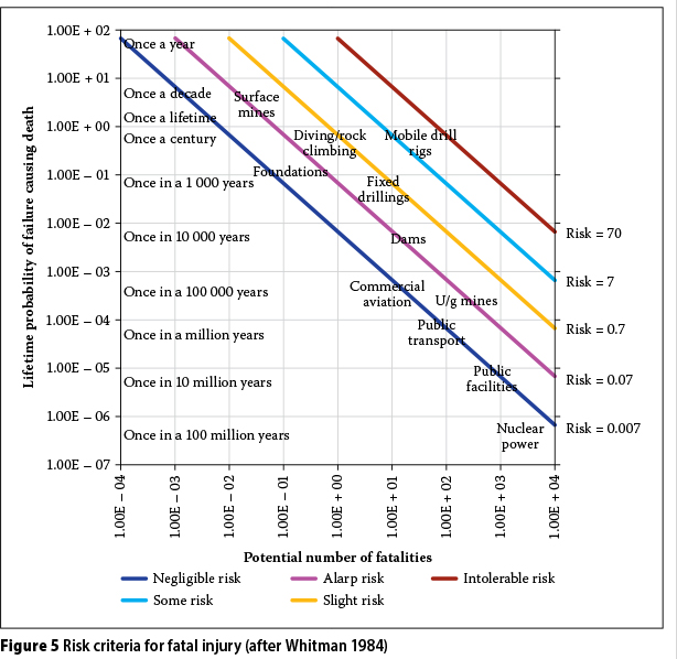
Threshold levels for fatal injury may be presented after Whitman (1984) as shown in Figure 5 in terms of lifetime probability, Pt, and the potential number of lives lost per house, N. The ordinate axis may alternatively represent the relative lapse of time in anecdotal terms as shown. The product of the probability of fatal injury along the ordinate axis and the potential number of lives lost per house along the abscissa axis is defined as the risk. The product of the probability of fatal injury and the potential number of lives lost per house are constant along the inclined lines in Figure 5. The inclined lines represent constant levels of risk that increase from "negligible risk" at the bottom to "intolerable risk" at the top. The descriptions of the different levels of risk in Figure 5 correspond to international usage. The relationship between lifetime probability of injury, Pt, and the potential number of lives lost per house, N, for any particular risk level, R, is given by Expression [5]:
Population density
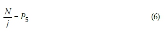
Let j denote the average number of people per house. In this instance j = 5. By definition the proportion N/j represents the probability of people in a house fatally injured by a coincident sinkhole, that is, P6. Thus:
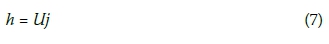
Let h denote the number of people and U the number of houses per hectare. Thus:
Overall probability of fatal injury
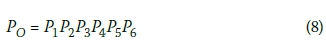
As submitted, a number of events need to happen simultaneously for people in a house to be fatally injured, namely, the sinkhole has to occur, the sinkhole has to coincide with the house, the house has to collapse catastrophically, the house has to be occupied by people, the people have to be at home at the time and people in the house need to be fatally injured. The overall probability, PO, that people in the house are fatally injured can therefore be obtained by multiplying the probabilities for the six underlying events as in Expression [8]:
As indicated in the definition of P6, inclusion of P6 in Expression [8] provides for the situation in which not all the occupants of the house are fatally injured when affected by a sinkhole.
The overall probability, PO, should be < Pt, the threshold probability of fatal injury for the particular risk level considered. The cumulative number of people per hectare, h, in respect of whom this condition is satisfied, i.e. the permissible population density, corresponds to all values for which F = Pt/PO> 1.0. Thus, by substitution from Expressions [5], [6] and [8],
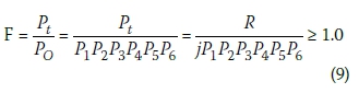
The number of people per hectare, h, appears in the power U = h/j in the expression for P2 in Expression [9].
EVALUATION OF PERMISSIBLE POPULATION DENSITIES
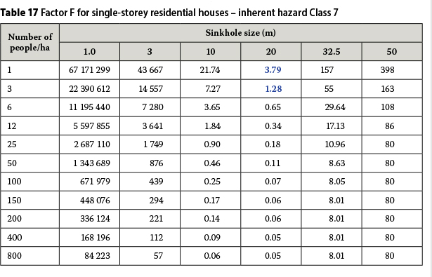
Values for ratio F in Expression [9] are shown for ranges of population density and sinkhole size for Inherent Hazard Classes 2 and 7 in Tables 16 and 17 respectively. Similar tables can be developed for the remaining six Inherent Hazard Classes. The values for F correspond to a "negligible risk level" as defined in Figure 5, i.e. to R = 0.007. The values for F in Tables 16 and 17 have a minimum turning point character for particular population densities. The maximum population density for any Inherent Hazard Class corresponds to that value for which ratio F > 1.0 for all sinkhole sizes.
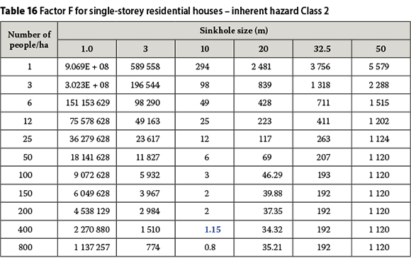
The maximum permissible population densities determined as described above for single-storey residential houses are summarised in Table 18 in terms of the sinkhole size for which factor F is approximately equal to unity. Owing to the minimum turning point character of factor F, the maximum population densities in Table 18 apply to all sinkhole sizes.
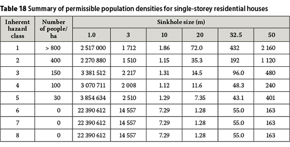
The maximum population densities correspond to 800, 400, 150, 100, 30, 0, 0 and 0 people per hectare for the eight Inherent Hazard Classes respectively. These densities are one-and-a-half to three times larger than the historically adopted maximum densities of 300, 200, 75, 100, 20, 0, 0 and 0 people per hectare for the eight Inherent Hazard Classes respectively. Based on observation over the past twenty years, the maximum population densities in Table 18 are considered by the authors to more accurately represent the perceived inherent hazard of sinkhole formation than the historically adopted densities.
As a result, the underlying sinkhole return periods for the residential infiltration regime in Table 9 are considered to be representative of the conditions in residential developments.
The number of people who can be accommodated per hectare at a risk R of 0.007 may not necessarily be able to be housed in single-storey dwelling houses at a maximum number of people per house of five. For example, the permissible number of people of 800 per hectare for Inherent Hazard Class 1 would require 160 houses, which cannot physically be fitted into one hectare. The maximum number of people who can be accommodated in the size of house considered amounts to 120 per hectare. A township consisting of two-and three-storey clusters can in principle accommodate three times as many people per hectare for the same indoor floor area per person. This density approaches that permissible in Inherent Hazard Class 2 of 400 people per hectare, but is still far below that permissible in Class 1 of 800 people per hectare. In effect, population density is not limited in Inherent Hazard Class 1.
The most probable number of fatal injuries will be determined by the number of houses affected by a 10 m sinkhole, since this size of sinkhole corresponds to the minimum turning point with regard to population density as shown in Table 18. A 10 m sinkhole can only affect one house of 120 m2 in floor area, following from which the most probable number of fatalities will in principle be 0.5 x 5 = 2.5 people.
EVALUATION OF SANS 1936:2012 LAND USAGE REQUIREMENTS
The permissible land usage requirements in terms of SANS 1936 - 1:2012 are compared with the population densities determined in this paper in Table 19, which is an extract of the land usage requirements in the standard on single-storey dwelling houses. The land usage requirements in SANS 1936 - 1:2012 are expressed in terms of maximum permissible population densities for four levels of precautionary measures represented by area designations D1, D2, D3 and D4 respectively, and briefly defined as follows:
■ D1 No precautionary measures considered
■ D2 Precautionary measures prevent concentrated ingress of water into the ground
■ D3 Additional precautionary measures to D2 requirements as provided for in the standard
■ D4 Precautionary measures determined rationally and specifically for the particular site
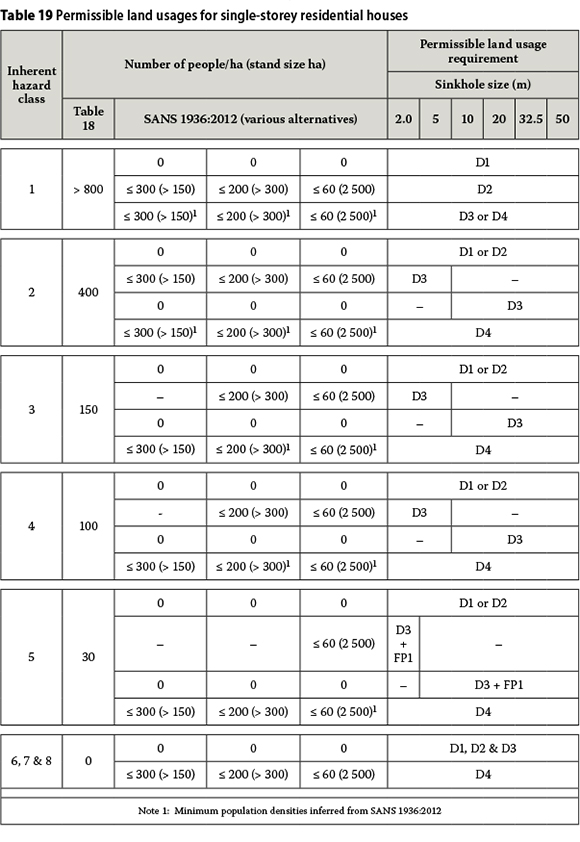
It follows by inference that the maximum permissible population densities for land usage requirements D1, D2 and D3 by definition correspond to minimum population densities for land usage requirements D2, D3 and D4 respectively, i.e. for an area designation one level higher in each instance, hence the minimum inferred population densities denoted by superscript "1" in Table 19.
The permissible population densities determined in the paper are not subject to the implementation of any specified precautionary measures. SANS 1936:2012 does not allow any people to be accommodated on dolomite land unless precautionary measures as specified in Table 19 are provided. The population densities corresponding to area designation D1 in the table are accordingly zero.
SANS 1936:2012 land usage requirement D2 for Inherent Hazard Class 1 is sensible, because it is always good practice to prevent the concentrated ingress of water into dolomite ground.
SANS 1936:2012 land usage requirement D3 for Inherent Hazard Class 2 is considerably more onerous than determined in the paper. Inferred land usage requirement D4 for Inherent Hazard Class 2, if appropriate, may be unduly onerous.
SANS 1936:2012 land usage requirement D3 for Inherent Hazard Class 3 is more onerous than determined in the paper, especially with regard to the limitation on sinkhole size. Inferred land usage requirement D4 for Inherent Hazard Class 3 is sensible.
SANS 1936:2012 land usage requirement D3 for Inherent Hazard Class 4 is sensible compared to that determined in the paper, except for the limitation on sinkhole size. Inferred land usage requirement D4 for Inherent Hazard Class 4 is sensible.
SANS 1936:2012 land usage requirement D3 + FP1 for Inherent Hazard Class 5 is sensible compared to that determined in the paper, except perhaps for the limitation on sinkhole size. Inferred land usage requirement D4 for Inherent Hazard Class 5 is sensible.
SANS 1936:2012 land usage requirements D1, D2 and D3 for Inherent Hazard Classes 6, 7 and 8 are sensible compared to that determined in the paper. Inferred land usage requirement D4 for Inherent Hazard Classes 6, 7 and 8 is sensible.
CONCLUSION
The objective of this paper is to present a methodology in terms of which the various factors that determine the risk of fatal injury when a sinkhole gives rise to the collapse of a single-storey dwelling house, can be rigorously accounted for on the basis of probability theory and in terms of which it can in principle be shown how mathematical modelling can be applied to address some of the issues on personal safety that are involved.
The values for the underlying parameters are estimates based on subjective engineering judgement and can be adjusted considerably. However, the overall result of the proposed methodology, based on the parameter values considered, is in principle compatible with long-standing observation by the authors.
ACKNOWLEDGEMENTS
The support of the Council for Geoscience to undertake the work described in this report is gratefully acknowledged. The contribution that Dr Kleywegt made to the development of the geological time-based sinkhole return periods is sincerely appreciated.
REFERENCES
Buttrick, D B, Van Schalkwyk, A, Kleywegt, R J & Watermeyer, R B 2001. Proposed method for dolomite land hazard and risk assessment in South Africa. Journal of the South African Institution of Civil Engineering, 43(2): 27-36. [ Links ]
Kirsten, H A D, Heath, G J, Venter, I S, Trollip, N Y G & Oosthuizen, A C 2009. The issue of personal safety on dolomite: A probability-based evaluation with respect to single-storey residential houses. Journal of the South African Institution of Civil Engineering, 51(2): 26-36. [ Links ]
Whitman, R V 1984. Evaluating calculated risk in geotechnical engineering. Journal of Geotechnical Engineering, 110(2): 145-188 (paper no 18569). [ Links ]
 Correspondence:
H A D Kirsten
PO Box 17, Fontainebleau
Johannesburg, 2032
South Africa
T +27 11 782 5861, F: +27 11 782 0817
E: hadk@mweb.co.za
G J Heath
Private Bag X5
Westonaria, 1780
South Africa
T +27 83 579 3806
E: greg.heath@sibanyegold.co.za
I S Venter
PO Box 36114, Menlo Park,
Pretoria, 0102
South Africa
T +2 7 82 5 70 1914, F: +27 1 2 460 0021
E: isak@thegeohub.co.za
A C Oosthuizen
Private Bag X112
Pretoria, 0001
South Africa
T +2 7 82 410 1148, F: +27 86 615 6682
E: toosthuizen@geoscience.org.za

DR HENDRIK KIRSTEN Pr Eng co-founded SRK Consulting in 1974. For 50 years he has specialised in complex practical geotechnical engineering problems, and has carried out 150 projects and published 90 papers. He is a member of CESA (Consulting Engineers South Africa) and a Fellow of SAICE, SAIMM and SANIRE (South African Institution of Civil Engineering, Southern African Institute of Mining and Metallurgy, and South African Institute of Rock Engineering respectively). His current projects include assuring statutory compliance of dolomite land use, geotechnical site safety licencing for nuclear power generation, design of sub-level open stope mine stability, and expert witnessing on construction and mining contracts. Dr Kirsten recently published guidelines on the implementation of quality and risk management in consulting engineering practice.

GREG HEATH completed his BSc Hons (Engineering Geology) at the University of Pretoria in 1990. He worked for the Council for Geoscience until 2012, where he undertook dam, dolomite and township investigations, as well as led research on dolomite. He completed his MSc Eng (Wits) in 2009 on the location and closure of unsafe, abandoned mine shafts. He currently leads the Ground Stability Unit at SibanyeGold.

ISAK VENTER is a generalist engineering geologist with 42 years' experience. He studied geology at the University of Pretoria, obtained an MSc (Engineering Geology) cum laude from the University of London and a DIC from Imperial College in 1976. He subseguently worked at the Geological Survey of South Africa, the University of Pretoria and at SRK. He joined Van Wyk and Louw (which later became Africon and now is Aurecon), where he was the Director for Geotechnics and the Environment from 1987 to 2004. He is now with the Geotechnical Hub.

THARINA OOSTHUIZEN Pr Sci Nat completed BSc (Hons) and MSc degrees in Engineering and Environmental Geology at the University of Pretoria in 2003 and 2013 respectively. She started her career in the mining environment where she was involved in high-wall stability monitoring and exploration until late 2005. When she joined the Council for Geoscience in 2005 she was initially involved with foundation investigations for dams. She currently works in the field of dolomite, where she conducts research and oversees the dolomite stability peer review reports. Tharina is a member of the South African Institute for Engineering and Environmental Geologists (SAIEG)

