


Services on Demand
Article
 English (pdf)
 Article in xml format
 Article references
Indicators

Related links
-
 Cited by Google
 -
 Similars in Google
Share

 Permalink
Journal of the South African Institution of Civil Engineering
On-line version ISSN 2309-8775
Print version ISSN 1021-2019
J. S. Afr. Inst. Civ. Eng. vol.56 n.1 Midrand Jan. 2014
TECHNICAL PAPER
Impact of the Gautrain on property development around station precincts
R Mushongahande; C E Cloete; C J Venter
ABSTRACT
The paper assesses the impact of the recently completed Gautrain Rapid Rail link in Gauteng on property development in the vicinity of stations along the route. Our particular interest is in examining the extent to which the Gautrain, as a major public transport investment, has managed to stimulate and support the creation of Transit-Oriented Development (TOD) by leveraging private sector action, with the ultimate aim of moving towards more sustainable land use / transport environments. Data sources include property development records, aerial photographs and municipal zoning applications for the areas surrounding the Pretoria, Midrand, and Rosebank stations for the period 2000 to 2011, and interviews with officials and private property developers. The research found evidence of accelerated property development and increasing mixed use in all three station precincts, but significant variation in the extent to which TOD principles have been applied. Property developers considered the Gautrain to be a major factor attracting them to develop in station precincts, suggesting that the locational benefits offered by a high-quality public transport system are also present locally. However, when comparing the vibrant Rosebank with the slower-growing Pretoria and Midrand precincts, it is clear that real estate fundamentals drive property development and will ultimately determine the success of a TOD undertaking.
Keywords: transit-oriented development, property development, land use planning, transportation planning
INTRODUCTION
Transit-Oriented Development (also referred to as TOD) is a potentially useful concept around which to promote sustainable development. It seeks to increase accessibility through public transport, and promotes the human mobility approach to transport that encourages planning for non-motorised transport forms where people can walk and cycle more than drive (Department of Housing 2000).
Property development plays a crucial role in achieving the objectives for successful TODs. Marx et al (2006) acknowledged that TOD cannot happen without the involvement and commitment of property developers. Utter in Curtis et al (2009) commented that, while the public sector invests in transit systems and station area plans, it actually falls to private sector developers to implement and build these vibrant TOD areas. Similarly Cervero et al (2004) pointed out that property developers "... occupy the front lines of TOD, organizing the financial, physical, and human resources needed to build projects around transit stations." However, while property developers involved in TOD neighbourhoods acknowledge TOD as a smart investment in congested and built-out urban areas, their hope is to reduce development costs, increase income and enhance profitability (Dittmar & Ohland 2004).
The Gautrain Rapid Rail project has been positioned as a potential catalyst for TOD in Gauteng (Du Plessis 2010), perhaps showing the way for sustainable urban development elsewhere in South Africa. Anecdotal evidence suggests that developer interest in some station precincts - notably Sandton - has increased sharply in response to the station development. Gautrain reports, for instance, that property transactions within two kilometres of its stations have grown much faster than further away from the stations (Gautrain 2008). In light of the existing widespread advocacy for TOD, the newness of the Gautrain project in South Africa, and the subsequent implementation of the TOD concept at station areas, this paper investigates the impact of the TOD concept on property development in the case of the Gautrain. The paper evaluates the spatial TOD elements implemented at a number of stations, and then evaluates the property development projects undertaken in line with the TOD elements. We seek to understand which elements of TOD - if any - are found attractive enough by local property developers to alter their investment decisions. Even though Gautrain itself has been operational for barely two years (at the time of writing), its planning process has lasted a decade - enough time, we argue, for some early trends in property response to emerge. The paper will be of use to local government, transport agencies and metropolitan municipalities in formulating development plans that encourage property development for successful TODs.
TOD PRINCIPLES
Cervero (2009, in Curtis et al 2009 ) pointed out that TOD "... is a straightforward concept: concentrate a mix of moderately dense and pedestrian-friendly development around transit stations to promote transit riding, increased walk and bicycle travel, and other alternatives to the use of private cars." Four spatial principles characterise TOD worldwide:
TOD Principle 1: Mix of land uses
The mix of uses in TOD is crucial in facilitating ridership of public transport, as different uses tend to generate different trip volumes at different times of the day. International studies have shown that residential uses, with the correct density, are key in facilitating trip generation; retail uses generate ten times more trips per unit than office use; office uses induce higher public transport use during peak periods; while industrial uses have a limited impact on public transport use (The Gautrain Project 2011). Cervero et al (2004) commented that industrial uses are generally discouraged in TODs, although not always.
TOD Principle 2: Availability of reliable public transportation systems
There should be a reliable public transportation system that links the TOD neighbourhood and the broader region, and meets the demands of the travellers. Newman & Kenworthy (2007) noted that the key to move towards sustainability is to provide transport modes that have a competitive speed advantage for long trips through transit and for short trips through walking and biking.
TOD Principle 3: Walkability
Walkable distances, pedestrian-friendly infrastructure, and attractive and safe landscaping are essential to enhance access to public transport stations by users of properties within the neighbourhood and beyond.
TOD Principle 4: High-density compact development
Viable public transportation systems require fairly high levels of density which can sustain their operations and improve affordability.
PROPERTY DEVELOPMENT FUNDAMENTALS
Wilkinson, Reed & Cadman (2008) defined property development as:
"... a process that involves changing and intensifying the use of land to produce buildings for occupation. It is not the buying and selling of land for a profit; land is only one of the raw materials used. Others include the building materials, infrastructure, labour, finance and professional services."
Property development can be brownfields where existing buildings are redeveloped, or greenfields where new buildings are erected. It can also be distinguished in terms of the various property uses, i.e. residential, commercial (which includes offices and shops) and industrial; as well as various property classes: office property grades, for example, range across Grades P, A, B and C, where P denotes premium with top quality modern space and C denotes the lowest quality space (Cloete 1999).
Key drivers of property development include inter alia:
■ property market demand
■ availability of land in a good location
■ design of buildings
■ availability of finance
■ management of completed buildings, and
■ profitability of the project.
The interplay of these property development fundamentals influences the decision of a developer to engage in a property development project.
TOD IMPACT ON PROPERTY DEVELOPMENT FUNDAMENTALS
The four essential principles of TOD can, according to the literature, appeal to the fundamentals of the property development process in several ways. Each TOD principle is discussed in relation to its potential impacts on property development.
TOD Principle 1: Mix of land uses
Availability of land in a good location
The biggest challenge in implementing mixed-use projects in TODs is the difficulty in assembling a sufficiently large piece of land. Utter in Curtis et al (2009) commented that a large piece of land is required to accommodate an interesting mix of uses as well as the layout plan of the neighbourhood as a whole. Greenfields station areas have the benefit of the availability of land to allow the development of ideal TOD type of properties. This is unlike brownfields station areas where development of TOD type of properties has to be done by refurbishment or demolition and subsequent redevelopment of existing properties; this might not be an easy decision for a property developer to make, in light of other crucial real estate fundamentals.
Good design
One of the challenges with mixed-use projects is the integration and coordination of the many uses that should be incorporated within the project in order to maintain its mixed-use nature. For instance, Fruitvale transit village in Oakland, California, experienced a problem of lack of adequate access to the retail area, as commuters could park their vehicles in the park-and-ride lots and then use the transit system without passing the retail area (Dittmar & Ohland 2004).
Availability of finance
Mixed uses incorporated vertically in a property pose challenges in terms of getting funding from financial institutions, who perceive the risks involved in property market cycles for different uses. Most financial institutions provide funding using common standards applicable to all properties, making it irrelevant that a property is in a TOD neighbourhood. In a survey undertaken by Cervero et al (2004) one lender commented that TOD seemed to be largely an irrelevant concept for lenders, as far as financing issues were concerned. Instead the focus was on regarding the TOD property developments simply as mixed-use projects that have the added bonus of being near a transit stop.
TOD Principle 2: Availability of reliable public transport systems
Profitability of property
Property developers aim to improve profitability of the property by investigating all the possible ways of keeping costs to a minimum while maximising income that can be derived from the property. Wilkinson & Marks (2007) pointed out that expediting the approval process for TOD projects facilitates property development as it helps reduce the developer's holding costs. The land costs, design of a project, cost of finance and repayment period are crucial aspects that influence project costs. McLinden (2006) commented that construction costs in TODs are high, because construction must be done in a manner that minimises interruption of traffic at infill or redevelopment sites near busy intersections. In addition, developers are required to provide additional services such as park-and-ride facilities and bicycle paths. The incorporation of transit elements is reported by one developer in Pittsburg to have added 10% to 12% to the normal cost of development (McLinden 2006). Development costs are also influenced by an increase in property taxes as a result of increasing property value. By way of example, property taxes in Jersey City, Essex Street Corridor, which were estimated at $200 000 to $300 000 per annum before the rail line's completion, increased to between $4 million to $6 million a year after the opening of the rail line in 2004 (Marx et al 2006).
Even though there are high costs associated with developing property in TODs, there is a potential rental premium that can be achieved from properties in TOD neighbourhoods. This rental premium is due to location efficiency of properties in TODs caused by the synergy of all the elements of TOD. Research findings from literature show that properties that are close to transit stations tend to experience increased values ranging from 6% to 24% for residential properties, and up to 50% for office and retail properties in American cities (Cervero et al 2004).
Staley (2009) argues that the relationship between property investment near rail stations and transit ridership is not direct; in other words, any increases in the values of properties in TOD are not entirely based on a property's proximity to transit. The underlying causes of property value premiums include public safety, access to jobs, quality housing, tax rates, financing and zoning. Access to transit systems is probably further down the list than these other factors, and so transit ridership alone does not drive property development decisions around light rail stations. It should not therefore be presumed that simply improving access to mass transit will push property development in a significant way. Staley went on to conclude that policies should emphasise transit as an amenity that local residents and businesses require rather than as a driver of market demand and value. A study by Deakin & Mejias in 2005 of property development activity along San Pablo Avenue in Oakland supports Staley's argument, as it found that developers view transit availability as a bonus, but not necessarily a major development incentive (Blume 2008). McLinden (2006) also supported Staley's argument when he quoted an architect as saying that "... transit alone is not the secret ingredient to a successful development. Real estate fundamentals have to be there at a transit stop ..."
Nevertheless, it is crucial to note that the type, quality and route of public transport technology influence the property value premiums. TODs served by heavy rail transit tend to experience higher premiums because of higher speeds, more frequent services and wider coverage, and architectural integration. For light rail systems, property value premiums tend to be smaller than for heavy rail. In some instances residential properties within 900 feet of stations actually sell for less because of the transit system's "nuisance effect." Value premiums are also influenced by the type of neighbourhood. Proximity to transit tends to increase value for lower-income neighbourhoods, while it may reduce value for high-income neighbourhoods. Property values in TOD neighbourhoods are also enhanced by the availability of developable space.
It can therefore be concluded that, although construction costs are high in TODs, the subsequent increased value of property facilitates enhanced profitability for successful property development in TODs.
Good market demand for property in TODs
There are many demographic and cultural changes in America that indicate that TOD will be a long-lived trend (Utter in Curtis et al 2009). These indications include ageing of the population, immigration and race, climate change, healthy communities, as well as rising transportation costs. Traffic congestion creates an increasing willingness to pay a premium for housing near rail stations, even if this means living in smaller houses on smaller stands. In South Africa, there is as yet little evidence of this, except for anecdotal indications of a growing demand for urban living.
TOD Principle 3: Walkability
Good design
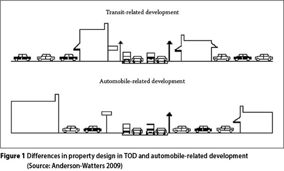
The need to provide walkable distances in TODs influences the design elements of property. Designs that provide more pedestrian space on the premises through the use of arcades, atriums and open courtyards are effective in encouraging people to walk (Anderson-Watters 2009). Pedestrians are sensitive to the safety and attractiveness of the route they follow, and normally choose the shortest and most convenient route. In Clarendon in America, sidewalks encouraged pedestrian activity by creating a sense of safety and vitality (Dittmar & Ohland 2004).
The differences in property design principles for TOD neighbourhoods and automobile-based neighbourhoods are shown in Figure 1.
Proper management of property
A proper management plan should be put in place for a TOD neighbourhood as a whole in order to maintain its characteristics and value. The use of the City Improvement Districts (CIDs) concept goes a long way towards promoting the use of non-motorised modes of transport (Downs 1991). Proper maintenance of the neighbourhood pavements, courtyards and buildings also promotes walking. In Emerson Park in America, a lack of proper maintenance of public infrastructure, open spaces and houses led to the deterioration of the residential units and the neighbourhood as a whole (Dittmar & Ohland 2004). Proper marketing plans of a neighbourhood also attract people to that neighbourhood, and hence the use of walking facilities provided thereto. Jacobson & Forsyth (2008) commented that appropriate programming of events and festivals can improve usage, safety and a sense of place within a TOD neighbourhood.
TOD Principle 4: High-density compact development
Availability of land in good location
Land is a scarce resource and compact densities in TOD assist, significantly, the supply of developable land. The concept of compact densities is promoted by relaxing zoning and building regulations, assisting particularly in brownfields developments.
Profitability of the project
Compact densities allow property developers to reduce property development costs in terms of providing services. The construction of high-rise semi-detached housing can also be cheaper, as there are shared costs among units - for example, the cost of shared walls is spread among the owners of the units, and even the installation of plumbing services is cheaper when units are clustered.
On the other hand, where development costs increase as a result of building in a TOD neighbourhood, developers have been found to benefit from increased density, as it helps them to offset the extra costs experienced in TOD projects by increasing the lettable space, from which rental income will be realised (McLinden 2006).
Availability of market demand for TOD
There is a strong market demand in the developed world for TOD compact densities and affordable housing that is attractive, liveable and interesting. Cervero et al (2004) pointed out that the interest of private property developers in TOD is derived from an increasing market for transit-oriented living, working and shopping, particularly in big cities where traffic congestion is a problem.
Public policies, such as those aimed at increasing affordable housing in TODs, also further enhance the market for TOD.
METHODOLOGY
The Gautrain stations can be classified into three distinct groups, according to the type of area (inner city, brownfields or greenfields) in which they were developed, as depicted in Table 1. The Pretoria, Midrand and Rosebank stations were chosen as typical representatives of stations in an inner city, greenfields or brownfields type of neighbourhood, respectively.
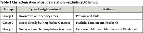
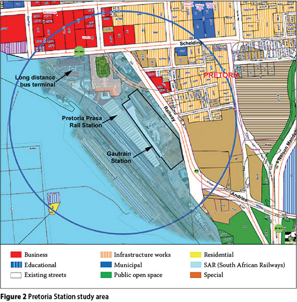
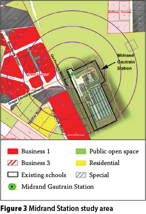
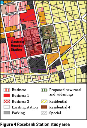
Study areas have been defined to be the areas within a 400 m radius of the selected Gautrain station (shown in Figures 2 to 4), in line with the typical primary catchment area radius of transit (Vuchic 2005). Our analysis aimed at identifying the extent to which private property development within this radius responded to the TOD concept during the planning and construction phases of the property.
Data was collected from archival records of the land development applications register and building plans register of the metropolitan municipalities of Johannesburg and Tshwane for the period 2000 to 2011. Aerial photographs for the same period were also utilised to assess the changes in property status over the years.
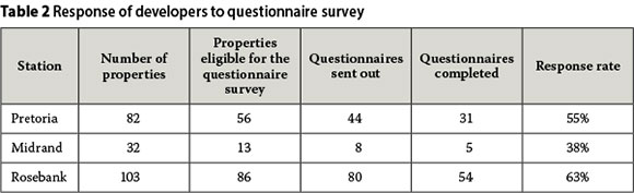
A questionnaire survey was also undertaken with developers in the study area in order to qualify the data provided by secondary data sources. The survey excluded all properties owned by the government and those owned by sectional title, as the aim of the study was to assess the views of private property developers. Table 2 summarises the size of the sample.
The questionnaires collected data on the timing of property acquisition and development in the station area, and reasons for the selection of the particular site. Respondents were also asked to rate the significance of the main TOD principles in motivating their choice of property development. Qualitative data was analysed using thematic content analysis, in order to get an understanding of the response of private property developers to the TOD concept. An interview was also conducted with an official from the Gautrain Management Agency in order to gain insight into the role of TOD principles during the development of the station precincts.
RESEARCH FINDINGS
TOD principles implemented at selected Gautrain station areas
The Gautrain Rapid Rail link has been regarded as a catalyst to create a new urban environment, in the form of TOD. The aim is to create long-term sustainability of the Rapid Rail Link by achieving optimal rider-ship. While the Gautrain bus feeder and distribution system was implemented to enlarge the catchment area of the rail service, true sustainability in the long run requires cultivation of ridership from within the immediate vicinity of the stations. To achieve this goal, the spatial principles of TOD need to be realised incrementally around station precincts. Gautrain seemed to be eminently aware of this.
In an interview with an official from the Gautrain Management Agency the importance of policies emerged as a strong catalyst for the development of TOD at the station precincts. He cited the preparation of local spatial development frameworks for each of the station precincts which inform the implementation of the much needed spatial principles of TOD. He further identified other policies, such as the Rosebank City Improvement District, the Dunkeld Residents Association for Rosebank, Intersite development proposals for the larger Pretoria Station precinct, and the Department of Public Works land assembly for the Pretoria Station precinct.
Pretoria Station
Types and mix of uses
Pretoria Station is situated on the edge of a central business district (CBD) which, although already formally established, includes many fairly old and dilapidated buildings. One of the aims of locating the station here has been the revitalisation of the declining CBD through the upgrading and improvement of the area, as well as the encouragement of business, residential and tourism facilities. The study area comprises 82 properties. The property type is identified by the use of the buildings as observed on the ground by the researcher and verified by the provisions of the town planning scheme for the area. Table 3 shows the types and mix of uses found around the Pretoria Station, indicating residential to be the dominant use.
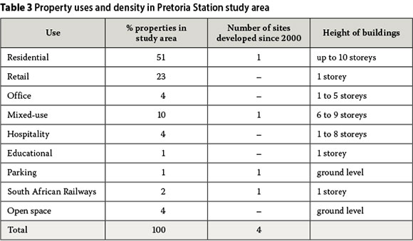
Most of the residential properties are low-rise stand-alone houses. These constitute 43% of the residential units, while high-rise residential flats constitute 40% and vacant stands constitute 17%.
Hospitality properties in this area are primarily hotels. Parking premises and open spaces are municipal-owned. Mixed-use properties predominately comprise retail use on ground floors and residential flats on upper floors, which constitute 75% of mixed-use properties, while mixed-use properties comprising retail and offices constitute 25% of the mixed-use properties.
Density
The density of property as depicted by the height of the building is presented in Table 3. The tallest building has ten storeys and is residential high-rise. All the mixed-use properties are located in the same locality and range in height from six to nine storeys.
The Gautrain Pretoria Station Development Framework (Tshwane 2003) provides the densities required to sustain the Gautrain Rapid Rail link. These desired densities for the Pretoria study area are not very different from the existing status shown in Table 3, owing to the nature and location of Pretoria Station in an already densely built area with a good mix of uses. The development framework hence provides that densification in this node will be achieved by developing residential properties and converting empty offices into residential accommodation.
Use of non-motorised transport
The use of non-motorised transport in this neighbourhood is of a high level, as it is a busy area with a number of public transport facilities which generate many pass-by and transferring walking trips, in addition to trips originating at the office and residential properties in the precinct. Sidewalks and open spaces are already well provided, and Gautrain invested in improved sidewalks and crossings immediately adjacent to the station. Nevertheless, some existing sidewalks are in a poor state of repair, which negatively affects safety and the quality of the walking environment. The northern side of the neighbourhood comprises a terrain with a relatively steep gradient, which affects the ability to walk and cycle.
The availability of various modes of transport
Pretoria Station is a hub of public transportation systems comprising the Gautrain and its bus feeder system, Metrorail, long-distance buses, metered taxis and mini-bus taxis. Private vehicles are also used, as supported by the provision of parking space within the public open space and railway property.
Midrand Station
Types and mix of uses
Midrand is a greenfields station that has been integrated with planning proposals rather than existing development. The location east of the N1 motorway, in a sparsely developed spot, was chosen because it links the emerging Midrand CBD, Gallagher Estate (a conference venue), various planning proposals of the municipality, and a very large proposed mixed-use development named Zonk'Izizwe. The larger Midrand area is slowly transitioning from a low-density rural to a more urban environment, but it generally lacks pedestrian and public transport facilities. The station was thus earmarked for its future potential rather than its current vibrancy.
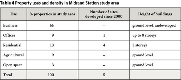
The Midrand Station study area comprises 32 properties. The type of use dominating this area is business, followed by residential, agricultural, offices and open space in that order (see Table 4). According to the Consolidated Johannesburg Town Planning Scheme (Johannesburg 2011), business use referred to here could include retail, offices, parking, showrooms and restaurants.
Density
The tallest building in the neighbourhood is eight storeys high, while all residential flats are three storeys high. Twenty-four out of 32 properties are undeveloped. The Midrand Urban Development Framework (Johannesburg 2008b) provides the required height of buildings in the study area that can sustain Gautrain as follows: the tallest buildings of up to 13 storeys are expected for properties closest to the station, while seven-storey and ten-storey properties are expected for properties further away from the station, at the edge of the study area. In comparison with the height of existing properties, it is clear that there is still a gap between the existing and the desired height of property. This gap indicates the need for some property development projects to be undertaken to meet the required densities that can sustain the Gautrain.
Use of non-motorised transport
The station precinct has limited walkability due to its location on a steep gradient and right next to a major arterial. The K101 road tends to create a barrier to walking due to its width, high traffic speeds, and insufficient sidewalks and pedestrian crossings. Streets are not labelled, making way-finding more difficult.
The availability of various modes of transport
The modes of transport found in the Midrand Station neighbourhood include private cars, the Gautrain and its bus feeder system, as well as minibus taxis. There are two taxi ranks in close proximity to the study area.
Rosebank Station
Types and mix of uses
Of the three study sites, Rosebank already displayed most TOD principles before the advent of the Gautrain. The area around the station was a well established node comprising a mix of primarily retail and office uses, with a strong tourism component. The buildings in the study area were generally in good condition, except for a few that required refurbishment. The implementation of the TOD concept was thus aimed at revitalising an existing urban node, as well as at promoting a mix of uses, particularly residential densification. The retail core and office components need to be managed and sustained in order to attract passengers for the Gautrain.
The Rosebank study area comprises 103 properties and is characterised by a variety of land uses. Table 5 shows that the dominant use is office use, followed by residential use. Hospitality, mixed-use, retail, educational and parking uses were also noted. The dominance of office use has been boosted by recent construction, as well as by the conversion of some houses into offices, mostly in the Parkwood suburb along Bolton Road.
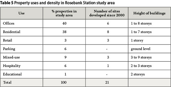
Residential properties are characterised by low-density and high-density residential apartments. Of all the residential properties, 79% are low-density stand-alone houses, 18% are high-rise apartments and 3% are vacant stands.
Although the statistics seem to show a low percentage of retail use, there is a lot of retail space in this node, which constitutes mixed-use. All the mixed-use properties tend to have a retail component. Similarly, office uses are also incorporated in all the mixed-use properties, while 33% of the mixed-use properties contain hospitality uses. The Rosebank Urban Development Framework (Johannesburg 2008a) describes the dominance of office space, as well as retail and hospitality, to be as a result of the character of Rosebank as a regional node within the Gauteng region.
Density
Table 5 shows that the tallest building in the area is a nine-storey mixed-use property comprising retail, offices and hospitality. The Rosebank Urban Development Framework (2008) provides the height of buildings desired in order to meet the required density and hence promote ridership of the train. The height of mixed-use properties is expected to be up to 20 storeys, offices up to 15 storeys and residential up to six storeys. This, in comparison with the current height of buildings provided in Table 5, shows that there is need for some adjustments to the existing densities in order to meet the desired densities for the Rosebank study area. Significant redevelopment of the low-density residential component would have to take place to make this happen.
Use of non-motorised transport
The mix of uses in the Rosebank study area, both horizontally and vertically, promotes walking within the neighbourhood. The Rosebank business district is very pedestrian friendly, as most of the streets have been pedestrianised and the station is well integrated with the mixed-use properties, forming the heart of the Rosebank neighbourhood. Where the streets have not been pedestrianised, appropriate sidewalks have been provided and intersections are signalised.
The availability of various modes of transport
Rosebank Gautrain Station neighbourhood is served by various modes of transport, including private cars, the Gautrain and its bus feeder services, Metrobus, metered taxis, minibus taxis, as well as the proposed bus rapid transport. Bus and taxi routes are generally well integrated, and all facilities are within walking distance of the node.
Identification of properties developed since the announcement of Gautrain in 2000
Pretoria Station
The Building Application register reflects all the applications for Building Control received by the municipality over the period 2000 to 2011. It provides an indication of where development is occurring on the ground and where developers are still in the planning stages. The register shows that in the Pretoria precinct 13 building control applications were received since the announcement of the Gautrain project, of which12 have a direct influence on new developments as they are applications for building plans approval and/or demolition of old buildings. Of these, five applications have been approved and, to date, the construction of four has commenced. Aerial photographs supplied by the Tshwane Municipality for the periods 2001, 2003, 2005, 2007, 2009 and 2010 confirmed that four properties were developed during that period. Apart from the railways-owned land used for the construction of bus and rail facilities, the developed land uses included residential, mixed-use and parking (Table 3).
The above analysis suggests that the extent of private sector development activity in the Pretoria Station area was rather modest and slow to emerge. This is partly due to a shortage in developable land, as most land in this area is railway-owned.
Midrand Station
Six properties were developed in the Midrand study area since the announcement of the Gautrain project in 2000. Of these six properties, five are new developments that were built and completed (as confirmed by both aerial photographs and building application data provided by the Municipality, as well as an interview with the Gautrain Management Agency official) - four residential and one office building. The Town Planning Application System shows that one property
- the mixed-use development of Zonk'Izizwe
- is at the planning stage, development rights already having been applied for.
Rosebank Station
Forty-seven properties went through some stages of property development, varying from planning the project to actual construction, since the announcement of the Gautrain project in 2000. This is approximately 44% of the properties in the Rosebank study area. Of the 47 properties, 68% made new development applications with the Municipality of Johannesburg in terms of the Town Planning Application System (TAS), representing the planning stage of property development. The remaining 32% were developed in line with the existing provisions of the scheme. The Building Application System also shows that 28 properties applied for building plans approval. Data derived from the researcher's physical inspection, in conjunction with the analysis of aerial photographs, as well as the interview with the Transit Management Agency official, shows that 20 properties went through the construction phase and one property went through demolition to become a vacant stand. There is clearly a high level of activity in the Rosebank Station node.
Role of TOD in private property developers' decision-making
Developers were asked to rate the importance of various TOD principles in their decision to invest in property within the station precincts (i.e. within 400 m of the Gautrain stations). Figure 5 shows the results. Results varied slightly between stations, suggesting that different considerations drive property development in different environments. In all three areas the availability of the Gautrain rated very highly, indicating that developers are aware of the potential of the rail system to improve the viability and profitability of their properties. Gautrain rated more highly in the more decaying (in the case of Pretoria) and more emerging (Midrand) nodes, suggesting that developers buy into the authorities' vision of leveraging nodal (re)generation through investment in the train system. In Rosebank, where many TOD elements were already present, Gautrain is considered equally important to the ability to achieve high densities and mixed-land uses, and supportive policies and incentives.
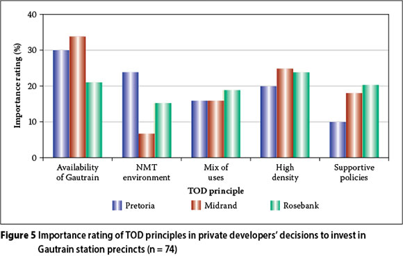
The importance of supportive policies and incentives was echoed during the interviews. Property developers' recommendations centred on the need to reduce the time of development and building approvals, the provision of incentives that can reduce the cost of construction for developers, and the possibility of specific financing for TOD property development. One important recommendation that was brought up by individual and small developer firms concerned the need to advertise the Gautrain more, to overcome the problem of lack of knowledge about the train.
CONCLUSIONS
Extent of TOD principles implemented at selected Gautrain stations
Literature identified a TOD neighbourhood as one that can foster sustainability by creating walkable, mixed-use, compact and vibrant places around high-quality public transport nodes, especially in automobile-dependent societies. Similarly this research identified four key TOD principles informed by spatial planning in the implementation of the TOD concept at the Pretoria, Midrand and Rosebank Gautrain stations. The principles are a mix of various land uses, higher density in terms of building heights, ability to walk and cycle in the neighbourhood, and the availability of various transport modes.
The research found that the amount of development that has taken place towards the TOD concept varies significantly across the three stations. There is evidence of accelerated property development and increasing mixed use at all three sites, but activity is by far highest in Rosebank where elements of TOD design - notably well-integrated mixed-use environments, pedestrianised spaces of high quality, and modal integration - are most present.
The preparation of local spatial development frameworks for each of the station precincts emerged as an essential commitment by the authorities to foster TOD, which could in turn motivate property developers to engage in building in the TODs. This research has shown, however, that none of the three stations has as yet fully met the spatial TOD principles provided by these frameworks. This confirms the findings of literature that TOD neighbourhood development takes a long time, more than a decade, to develop.
The Pretoria Station neighbourhood, being a downtown type of TOD in the CBD of Pretoria, has maintained the mix of uses and densities that existed before the Gautrain Rapid Rail Link project. The Midrand Station neighbourhood is a greenfields type of TOD neighbourhood where, literature shows, implementing a TOD can be fairly easy. However, the Midrand Station neighbourhood has not started to reflect the implementation of the provisions of the Station Development Framework. Property development in this neighbourhood is slow, as most of the land around the station is not developed and the large tract of land surrounding the station is owned by one entity, while most of the land west of the K101 is owned by another. Significant investment is needed to turn this largely vacant, car-oriented area into a TOD-supportive neighbourhood. This illustrates the risks involved in attempting to implement TOD in an area belonging to only one or two property developers. It seems easy for the property development process to be out of sync with the transport investment.
The study also demonstrates the importance of promoting residential land uses in TOD nodes, as these result in increased population density that improves ridership (and reverse ridership share). In both the Pretoria Station and Rosebank Station neighbourhoods there are substantial components of residential use, and some further residential development has occurred in recent years. Yet it seems most of this development is either of a low-cost or a low-density quality, which is not conducive to TOD success.
Rate of property development since the announcement of the Gautrain in 2000
Although the rate of property development varies significantly across the case study areas, there is evidence that the TOD concept does attract new development in the vicinity of Gautrain stations. Property developers consider the presence of the Gautrain to be a major factor influencing their decision to develop in these areas. The Gautrain is especially important in the less developed, less attractive nodes of Midrand and Pretoria. This suggests that, in line with international experience, the benefits offered by a high-quality public transport system in terms of permanence, nodal regeneration potential, and securing property demand, are also present locally.
What seems equally clear, though, is that there are real estate fundamentals other than the TOD principles that drive property development, and these will ultimately determine the success of a TOD undertaking. When comparing the vibrant Rosebank with the slower-growing Pretoria and Midrand precincts, a number of factors seem to contribute to its success: (1) prior successful mixed-use properties that demonstrated market demand at this location, (2) good design, (3) land available for development, and (4) the "location, location, location" factor of Rosebank as a regional node in Gauteng. It seems likely that the strong real estate fundamentals already present were further strengthened by the proximity and availability of the Gautrain Station.
CONCLUDING REMARKS
The outcomes of the research have generally tended to match the findings of the surveyed literature on the impact of TOD on property development. TODs in the western world, wherever implemented, take a long time to develop. In the South African context it has been eleven years since the announcement of the Gautrain project; yet, on the ground, the pace of change is slow and, in some cases, non-existent.
There might be merit in recognising that not all stations are good candidates for TOD - whether because of their location, development environment, or intermodal potential. It is important to identify in advance those with highest potential to enable energies to be focused where they will most effectively achieve the synergies needed to make TOD work.
In conclusion, it is possible that the slow manifestation of the TOD principles at some Gautrain stations inhibited private property developers' interest in investing in station areas. Developers need to see the commitment of government and the public transport agency in creating the TOD neighbourhoods as already applied at successful transit villages in the western world.
ACKNOWLEDGEMENTS
This research was financially supported by the Department of Transport through the Sustainable Public Transport and Sport Project, implemented by the United Nations Development Programme (UNDP), and funded by the Global Environment Facility (GEF).
REFERENCES
Anderson-Watters, C 2009. Transit-friendly design guidelines: A guide for planners, developers, elected and appointed officials. Frederick County, Maryland. [ Links ]
Blume, K 2008. Past Presidents' Award for Merit in Transportation: Bus rapid transit land development guidelines. ITE Journal, 78(11): 22-31. [ Links ]
Cervero, R 2009. Public transport and sustainable urbanism: Global lessons. In Curtis, C, Renne, L & Bertolini, L (Eds), Transit-oriented Development: Making it Happen, Farnham, UK: Ashgate Publishing, pp 23-35. [ Links ]
Cervero, R, Arrington, G B, Smith-Heimer, J, Dunphy, R, Murphy, S, et al 2004. Transit-oriented development in America: Experiences, challenges, and prospects. Washington DC: Transit Cooperative Research Program (TCRP), TCRP Report 102. [ Links ]
Cloete, C E 1999. Property Development, 2nd edition. Sandton: SA Property Education Trust, Vol. 1. [ Links ]
Curtis, C, Renne, L & Bertolini, L (Eds) 2009. Transit-oriented Development: Making it Happen. Farnham, UK: Ashgate Publishing. [ Links ]
Deakin, E & Mejias, L 2005. Redevelopment and revitalisation along urban arterials: Case study of San Pablo Avenue, California, from the developers' perspective. Quoted in Blume, K, 2008, Past Presidents' award for Merit in Transportation: Bus rapid transit land development guidelines. ITE Journal, 78(11): 22-31. [ Links ]
Department of Housing, South Africa 2000. Guidelines for Human Settlement Planning and Design. Pretoria: Government Printer. [ Links ]
Dittmar, H & Ohland G (Eds) 2004. The New Transit Town: Best Practices in Transit-oriented Development. Washington, DC: Island Press. [ Links ]
Downs, JC Jr 1991. Principles of Real Estate Management, 13th edition. Chicago: Institute of Real Estate Management. [ Links ]
Du Plessis, J 2010. Injecting a rapid rail link into a metropolis. Civil Engineering, 18(8): 63-66. [ Links ]
Gautrain Management Agency 2008. Gautrain is more than just a train. Mobility magazine, June/August. [ Links ]
Jacobson, J & Forsyth A 2008. Seven American TODs: Good practices for urban design in transit-oriented development projects. Journal of Transport and Land Use, 1(2): 51-88. [ Links ]
Johannesburg Metropolitan Municipality 2008a. Gautrain: Rosebank Station Development Framework. Johannesburg: Metropolitan Municipality, Development Facilitation Section. [ Links ]
Johannesburg Metropolitan Municipality 2008b. Gautrain: Midrand Station Development Framework. Johannesburg: Metropolitan Municipality, Johannesburg. Development Facilitation Section. [ Links ]
Johannesburg Metropolitan Municipality 2011. Consolidated Johannesburg Town Planning Scheme Johannesburg: Metropolitan Municipality, Town Planning Section. [ Links ]
Marx, P L, Stallsmith, E & Zimmerman, M V 2006. Developing transit. Journal of Mass Transit, 32(5): 42-48. [ Links ]
McLinden, S 2006. It takes a transit village. National Real Estate Investor, 48(11): 67-72. [ Links ]
Newman, P W G & Kenworthy, J R 2007. Sustainable urban form: Transport infrastructure and transport policies. In Garling, T & Steg, L (Eds), Threats from: Car Traffic to the Quality of Urban Life, Amsterdam: Elsevier. pp 293-311. [ Links ]
Staley, S 2009. Ridership no factor in transit-oriented-development. Available at: http://txurbanmxu.blogspot.com/2009/06/ridership-no-factor-in-transit-oriented.html (accessed on 5 July 2011). [ Links ]
The Gautrain Project 2011. Spatial development: Gautrain. Available at: http://www.gautrain.co.za/about/about-gautrain/studies-documents/spatial-development/ (accessed 19 April 2011). [ Links ]
Tshwane Metropolitan Municipality 2003. Gautrain: Pretoria Station Development Framework 2003. Pretoria: Tshwane Metropolitan Municipality, Development Planning Section. [ Links ]
Utter, M A 2009. Developing TOD in America: The private sector view. In Curtis, C, Renne, L & Bertolini, L (Eds), Transit-oriented Development: Making it Happen, Farnham, UK: Ashgate Publishing. [ Links ]
Vuchic, V R 2005. Urban Transit: Operations, Planning, and Economics. Hoboken, New Jersey: Wiley. [ Links ]
Wilkinson, P & Marks, A 2007. Promoting transit oriented development in the Atlantis Corridor, Cape Town: Towards an implementable model. Paper presented at the 26th Annual Southern African Transport Conference, Pretoria, South Africa. [ Links ]
Wilkinson, S, Reed, R & Cadman, D 2008. Property Development, 5th edition. London: Routledge. [ Links ]
 Contact details:
Rudo Mushongahande
Department of Construction Economics
University of Pretoria
Pretoria, 0002
South Africa
Box 579, Musina, 0900
T: +27 15 532 1055
M: +27 78 520 2083
E: rmushongahande@gmail.com
Contact details:
Chris Cloete
Room 3-16, Building
5 South Campus
University of Pretoria
Pretoria, 0002
South Africa
T: +27 12 420 4545
F: +27 12 420 3598
E: chris.cloete@up.ac.za
Contact details:
Christo Venter
Centre of Transport Development
Department of Civil Engineering
University of Pretoria
Pretoria, 0002
South Africa
T: +27 12 420 2184
F: +27 12 362 5218
E: christo.venter@up.ac.za

RUDO MUSHONGAHANDE holds a Masters Real Estate degree from the University of Pretoria (2012) and a BSc Honours in Rural and Urban Planning from the University of Zimbabwe (2000). She has seven years' working experience in property finance, development and valuation. She is affiliated to a number of professional bodies, amongst others the South African Council of Property Values Profession, the South African Council for Planners, the Zimbabwe Institute of Regional and Urban Planning, the Real Estate Institute of Zimbabwe and the Golden Key International Honour Society.
PROF CHRIS CLOETE is Programme Leader: Real Estate in the Department of Construction Economics at the University of Pretoria. He has presented about 80 papers at international conferences, has published 30 academic papers and is author or editor of 13 books. The awards that he has received include the British Council Fellowship for South Africa taken up at Oxford University (1973-1975), Outstanding Academic Achiever at the University of Pretoria (1996), Certificate for Educational Innovation at the University of Pretoria (1999 and 2002), first Honorary Life Membership of the South African Council for Shopping Centres (2000), and Fellow (as Eminent Member) of the RICS (2004).

PROF CHRISTO VENTER Pr Eng is an Associate Professor of Transportation Engineering in the Department of Civil Engineering at the University of Pretoria. His teaching and research activities focus on public transport, transport policy and planning, travel demand modelling, and social aspects of mobility. He Is a member of theSouth African Institution of Civil Engineering.

