


Services on Demand
Article
 English (pdf)
 Article in xml format
 Article references
Indicators

Related links
-
 Cited by Google
 -
 Similars in Google
Share

 Permalink
Journal of the South African Institution of Civil Engineering
On-line version ISSN 2309-8775
Print version ISSN 1021-2019
J. S. Afr. Inst. Civ. Eng. vol.51 n.1 Midrand Apr. 2009
TECHNICAL PAPER
The issue of personal safety on dolomite: a probability-based evaluation with respect to single-storey residential houses
H A D Kirsten; G J Heath; I S Venter; N Y G Trollip; A C Oosthuizen
ABSTRACT
In refining the principles supporting the safe and judicious use of land, the Council for Geoscience (CGS) is researching the use of a risk-based evaluation of the influence of development density on personal safety. This paper considers single-storey dwelling houses and is the first in a series that will also consider multi-storey and mixed-use developments. In much the same way that rainfall statistics are used to calculate flood events in order to control development by restricting it to above a fixed return period flood line, is it proposed to expand and apply the frequencies of sinkhole occurrence in order to arrive at a more rigorous expression of acceptable development densities for the eight "Inherent Risk Classes". A number of probability concepts are used in determining the development density. Depending on the incidence of each probability, it has been possible to determine the risk associated with development on dolomite for a single-storey dwelling. Recommended population densities are proposed for each Inherent Risk Class, with the exceptions of Risk Classes 6, 7 and 8, where no residential development is catered for, in line with industry standards.
Keywords: dolomite, sinkhole, coincidence, probability, residentia
INTRODUCTION
According to the Town Planning and Townships Ordinance No 15 of 1986, local authorities are tasked with coordinating a harmonious environment, which means promoting, amongst others, a healthy, safe and orderly environment.
Town planners have realised that most cities in South Africa have highly inefficient and unsustainable spatial forms, and are attempting to redress this. In line with directives from national and provincial legislation, municipalities have embarked on compaction and densification strategies. These strategies aim to densify areas of low development density, such as those in the so-called "affluent south" of Tshwane where large residential stands and agricultural holdings occupy vast areas of land. A sizable portion of this land is underlain by sinkholesusceptible dolomite rock, but town planners have never and still do not consider the dolomite-related risk to be serious enough to preclude mass densification. This is most evident in the Tshwane Regional Spatial Development Framework, which seeks to place or expand major development nodes on the dolomite. The situation is exacerbated by the placement of the Gautrain Rapid Rail Link through the Lyttelton Agricultural Holdings, with the Centurion Station located in its centre.
The Council for Geoscience (CGS), in terms of its function to study and advise on the judicious and safe use of land (Geoscience Act No 100 1993), is seen as the "watchdog" of development on dolomite. It realises that development density is a key aspect of the safe and judicious use of dolomite land, but because this works in the opposite direction to the need for densification, experiences opposition from planning professionals at local authorities and from developers. The CGS is therefore under increased pressure to clearly define dolomite-related risk and to establish a scientifically defendable basis from which to propose maximum sustainable residential development densities.
This paper aims to identify the principles of a probability-based evaluation of development density on dolomite for single-storey dwelling houses as it affects personal safety. Further research into the issue of risk exposure to human traffic in areas such as along roads and sidewalks within existing built environments, in both multi-storey and mixed-use development, is being carried out concurrently but is not addressed in this paper.
CURRENT APPROACH TO DOLOMITE RISK EVALUATION
The current approach to dolomite risk evaluation is first summarised below. This is followed by a short description of the method adopted in this paper to address the challenges of the current approach.
Background to the status quo
The broad aims of risk evaluation and development regulation in South Africa are to ensure the long-term sustainability of the occupation of dolomite land. This is done through dolomite risk management, leading to the protection of public interests. There is at present no single authority that has absolute control over what happens on dolomite and there is also no umbrella fund available to reimburse for losses suffered from dolomite-related incidents.
Risk evaluation for development on dolomite emerged in the early 1970s as a response to addressing the above aims. Early on it was realised that ground movement events were associated with two interlinking issues:
The particular ground profile present at the location under consideration
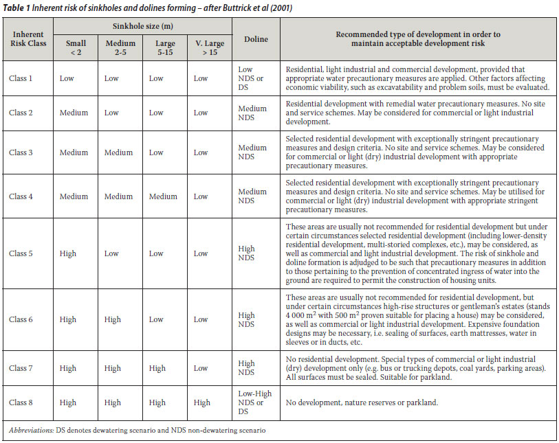
The first attempts at classifying and zoning land into areas of similar risk evolved into a generally accepted standard which is in use in South Africa today. The method proposed by Buttrick et al (2001) presents a scenario to which the dolomite ground is subjected in order to arrive at eight "Inherent Risk Classes". These assigned Inherent Risk Classes differ from one another in terms of the likelihood of the ground being mobilised, as well as the likely size of the feature that will develop at ground surface. The general approach then adopted is to manage development so that certain types of development are earmarked for specified Inherent Risk Classes.
This is depicted in Table 1, which shows the tendency to restrict residential development to the lower Inherent Risk Classes. Higher numbered Inherent Risk Classes are reserved for commercial and light industrial developments, based on the notion that more expensive and therefore more effective precautionary design measures can be implemented and more easily maintained by these developments to ensure their long-term safety and viability. The highest Inherent Risk Classes are reserved for open space and parkland only.
The Draft Standard SANS 10400 reinforces this approach by defining which building classes may be contemplated on the different Inherent Risk Classes of dolomite land, but fails to consider the issue of occupation density on high-risk dolomite land by allowing, for example, office development on Inherent Risk Class 6 areas. The intention to limit the numbers of people who inhabit the risk surfaces is nonetheless embedded in the draft standard as it currently stands.
The Council for Geoscience adopted the principle of limiting crowdedness in residential areas in October 2004 and established maximum numbers of residential stands per Inherent Risk Class. In this way the numbers of people who will reside within an area will be fixed and the likelihood of coincidence with a sinkhole could, in general terms, be kept low. The development density expressed in terms of numbers of units per hectare is shown in Table 2.

Proposed risk evaluation criteria
Although most ground movement events are triggered by controllable parameters, the numbers of sinkholes that are able to develop in a specific time period are also a function of the potential mobility of the profile. A higher mobilisation potential allows a greater number of sinkholes to develop per time period than a lower mobilisation potential. Waltham and Fookes (2003) gauged the extent of this inherent character trait of the karst environment by referring to the rate of formation of new sinkholes per square kilometre per year, while in South Africa research on a type area has shown that the statistics of Table 3 apply.

In much the same way that rainfall statistics are used to calculate flood events in order to control development by restricting it to above a fixed return period flood line, is it proposed to expand and apply the frequencies of sinkhole occurrence given in Table 3 in order to arrive at a more rigorous expression of acceptable development densities for different Inherent Risk Classes of dolomite land. The principles on which this proposed approach are based are described in more detail in the following section.
BASIC PROBABILITY CONCEPTS
A number of probability concepts are used in determining the development density for the purposes of this paper. These may be defined as follows.
Return period and related concepts
A T-year event is an event of such magnitude that the average time between events of larger magnitude is T years. This length of time is also referred to as the "return period".
The expected number of occurrences of a T-year event in an N-year period is n = N + T. It follows that T = N ÷ n, and also that the probability of a T-year event in any given year is P = T--1
Let D denote the lifetime of a residential development. The probability that a T-year event will be exceeded at least once in the lifetime of the development is given by:

Let A denote the area in hectares in which Q number sinkholes of a particular size in a particular class of dolomite ground occur, and let N denote the time in years in which they occur.
The product AN represents ha-yr which, when divided by Q, gives the return period for a sinkhole of a particular size and class. Thus:

Probability of a sinkhole coinciding with a house
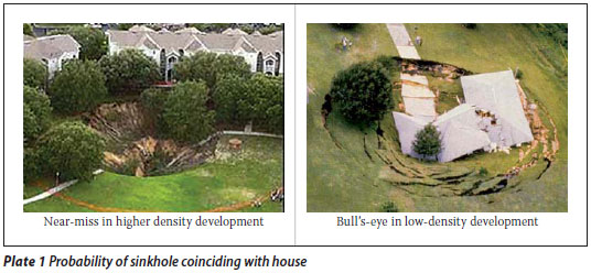
A sinkhole is considered to coincide with a house for all positions of the sinkhole in which its periphery either surrounds the centre of the house or at least touches it. This is shown in Figure 1 for sinkholes of 50 and 20 m diameter.
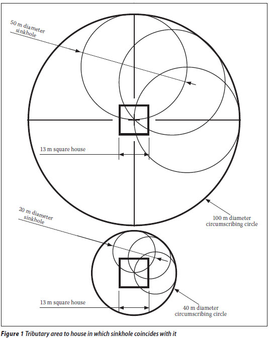
"Coincidence" (see Plate 1) in this context means that the sinkhole overlaps at least with somewhat less than half of the footprint of the house for very large sinkholes. Sinkholes less than half the dimensions of the house in diameter lie entirely within the outline of the house. Let a denote the size of the sinkhole. The probability that a sinkhole of this size will coincide with at least half of any of the houses in a development per hectare is therefore given by:

The numerator πa2 on the right denotes the area of the circumscribing circle of diameter 2a.
Probability of a sinkhole coinciding with a family group
Assume that the family group occupies an area of limited extent denoted by c2 within a house. A sinkhole would then coincide with the family group if the group occurs anywhere in a circle of diameter (2a - c) encompassing the family group, as shown in Figure 2.
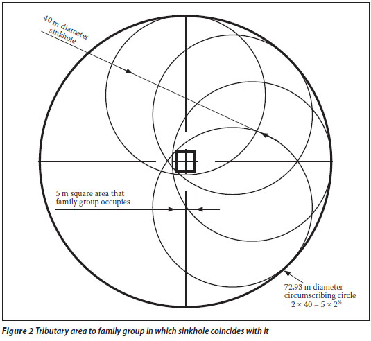

The probability of the sinkhole coinciding with the family group per hectare is therefore given by:

The probabilities of a sinkhole coinciding with a house and a family group, represented respectively by expressions (3) and (4), are plotted against sinkhole size in Figure 3.
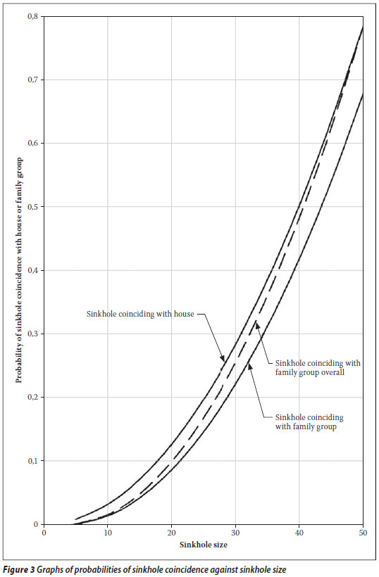
Parameter c is taken as 7 m in the figure. Coincidence of a sinkhole with a family group is represented by expression (4) for small sinkholes and by expression (3) for large sinkholes. This is because small sinkholes will hardly affect the whole house, while large sinkholes will engulf the whole house, together with the family inside it.
The probability of sinkhole coincidence with a family group may be taken to vary with sinkhole size, as given by the dotted line in Figure 3, represented by the expression:

| where | α = 3,64 |
| β = -25,9 | |
| γ = 45,4 |
Let U denote the number of houses or family groups per hectare. The probability that a sinkhole will coincide with any of the family groups per hectare is therefore given by:

Observe that the houses or family groups are not assumed to be evenly distributed in expression (6). Also observe that the simultaneous coincidence of any one sinkhole with a number of houses or families is accounted for by considering the coincidence of all sinkholes with any one house or family separately from other houses or families, as represented in expression (6).
Probabilities of relevant additional events
The following mutually dependent events have to occur in addition to sinkhole formation and coincidence with the family in order to cause personal injury:
P3 Probability of building collapsing on being struck by a sinkhole
P4 Probability of building being occupied when struck by a sinkhole
P5 Probability of occupants being at home when struck by a sinkhole
P6 Probability of some members of the family group being fatally injured when struck
Values for these probabilities for a range of sinkhole sizes may be arbitrarily assumed for single-storey dwelling houses, as given in Table 4.

Levels of tolerance for fatal injury
"Lifetime probability" is defined as the probable unit number of times that a detrimental event would occur during the life of the person affected. A natural lifetime is, on average, 70 years.
Levels of tolerance for loss of life in terms of lifetime probability and potential number of lives lost may be presented as shown in Figure 4 (after Whitman 1984).

The ordinate axis may, alternatively, represent relative lapse of time, as shown. It is accepted internationally that systems in which lives may be lost may be designed for an ALARP - As Low As Reasonably Practicable - level of risk.
The relationship between lifetime probability of injury, P7, and potential number of lives lost per family, N, for this risk level, R, is given by the following expression:

The relationship between lifetime probability and potential number of lives lost is given in multiples of 10 in Table 5. Observe that only probabilities of occurrence and relative frequencies of events are referred to in the table; tolerable risk criteria are not given.

Number of people per hectare
The number of people per hectare, m, may be expressed in terms of the average size of a family group, w, and the number of houses or families per hectare, U, by:

Observe that by definition:

Development density in terms of a sinkhole coinciding with a family group
As stated under Probabilities of Relevant Additional Events, six events need to happen simultaneously for some members of a family to be fatally injured:
The probability that some members of the family will be fatally injured can therefore be obtained by multiplying the probabilities for the six underlying events as follows:

The fault tree for this relationship is shown in Figure 5. The overall probability, P, should be < P7 for an ALARP risk level, as shown in Figure 4.

Therefore, from expression (7) in which P7 is given in terms of R and N:

The maximum development density in terms of the risk of a sinkhole coinciding with a family group is therefore given by:

ALTERNATIVE METHODS FOR DETERMINING PROBABILITY OF SINKHOLE FORMATION
Sinkhole formation is one of six events that have to occur simultaneously for some members of a family in a house to be fatally injured, as presented under Basic probability concepts. The probability of sinkhole formation may be determined in two alternative ways as briefly described below.
T-year event per hectare
Buttrick et al (2001) proposed a simple class-size distribution for sinkhole occurrence as shown in Tables 1 and 3. If instead of the three ranges of ground movement events given in Table 3, a geometric series of values of 0,1, 0,3162 and 1,0 for the three ranges is adopted, Table 1 may be alternatively presented as shown in Table 6.

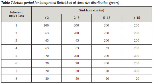
The return period, T, for every class-size entry in Table 6 may be obtained as shown in Table 7 by dividing 20 ha-yr by every entry in Table 6, as provided in expression (2). The return period represents the length of time that will elapse, on average, between events larger than the T-year event. The probability of the formation of a sinkhole of a specific class and size, or larger, is given by the probability that a T-year event will be exceeded at least once in the lifetime, as given by expression (1).
This is the approach used to determine the probability of the formation of a sinkhole of a specific class and size, or larger. As presented elsewhere in this paper, the approach is utilised in an "Invited Expert" class-size distribution and in a systematically deployed version of the Buttrick et al class-size distribution.
The approach has the advantage that it is simple and relatively quick to apply. It is also accepted locally as the basis, in principle, for assessing the intensity and frequency of sinkhole occurrence. A major criticism that can be levelled against it is that it is based on a class-size distribution determined by experiential judgment. Moreover, it can be argued that the class-size distribution is not a randomly varying statistic, because sinkholes are in general triggered by the infiltration of water that is largely due to carelessness or ignorant human oversight. A major difficulty in this regard is that sinkholes are constrained to occur close to leaking services, in areas affected by significant groundwater-level drawdown or surfaces where water ponds. As such, the occurrence is not a random phenomenon. It can be argued to some extent in defence of the T-year approach that human oversight is a randomly varying statistic and that the sinkholes that form as a result are themselves random events.
Geotechnical modelling of sinkhole development and size
The mechanism resulting in the formation of a sinkhole involves a series of successive events. Surrounding conditions determine whether these successive events will, in fact, eventually manifest as a sinkhole at surface.
This process can be divided into aspects that control the demands (loads) on the material that surrounds the voids and cavities in a dolomite residuum, and the capacity (strength) of the material. The probability of sinkhole formation can then be estimated by evaluating the likelihood that the aspects controlling the demand will exceed the aspects controlling the capacity. A fault tree representing this process is given (in principle) in Figure 6.

A significant advantage of this approach to determining the probability of sinkhole formation is that it accounts for the aspects that affect the process as random variables. A disadvantage is that evaluation of the likelihood that the aspects controlling demand will exceed those controlling capacity is complex and is based on experiential judgment. A further disadvantage is that the extent and shape of potential sinkholes need to be determined by numerical simulation. These aspects of the approach render it relatively inaccessible.
Accounting for dolomite construction compared with conventional construction
"Conventional construction" in this context refers to building methods and procedures in which no particular precautions are taken to prevent the occurrence of sinkholes. "Dolomite construction", on the other hand, refers to building methods and procedures that are specifically aimed at preventing the occurrence of sinkholes, but at the same time are commensurate with the economics of the development.
The potentially beneficial effect of dolomite construction on development densities for residential townships is not considered in this report, but may be taken into account in future developments. The occurrence of sinkholes will, in such instances, be based on appropriate geotechnical modelling of the geomorphologic processes in karst ground. This will, inter alia, involve fault trees of the causes underlying the development of nearsurface cavities in dolomite residuum and the subsequent collapse and/or settlement of the ground structure.
"INVITED EXPERT" CLASSSIZE DISTRIBUTION
The Buttrick et al class-size distribution given in Table 1 is limited in range because of the qualitative risk characterisation adopted from Table 3. The CGS attempted to overcome this limitation by experientially estimating the frequencies of occurrence of sinkholes of different size and class in quantitative terms.
Data for "Invited Expert" class-size distribution
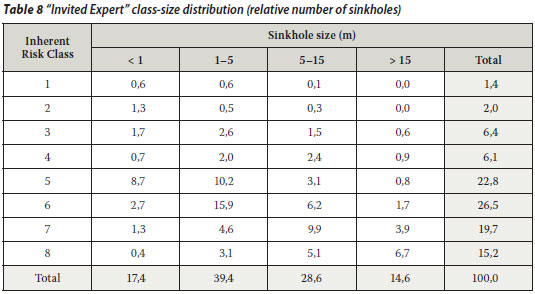
All the engineering geologists who are known to be involved in risk assessment for land development on dolomite ground were invited to estimate the distribution of the number of sinkholes in terms of size and ground class. Eight responses were received, of which the experience-weighted average is given in Table 8. The experience of the respondents was weighted arbitrarily, but did not make a significant difference. The individual distributions varied quite considerably with regard to both size and class. In what follows, this distribution is referred to as the "Invited Expert" class-size distribution.
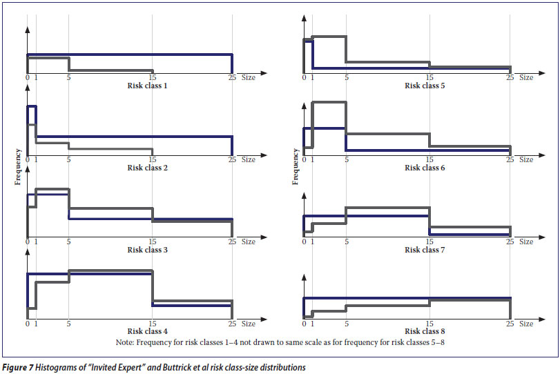
Comparison between "Invited Expert" and Buttrick et al risk class-size distributions
The Buttrick et al (2002) class-size distribution in Table 6 may be expressed as a percentage, as given in Table 9. It evidently differs significantly in key respects from the expert class-size distribution in Table 8. The relative numbers of sinkholes in Tables 8 and 9 are shown plotted against sinkhole size in Figure 7.

It is clear that the "Invited Expert" distributions vary continuously compared with the Buttrick et al distributions which are either constant or stepped.
DETERMINATION OF DEVELOPMENT DENSITIES
Development densities are determined below on the basis of the "Invited Expert" class-size distribution and an amended version of the Buttrick et al class-size distribution.
Development densities calculated from "Invited Expert" class-size distribution
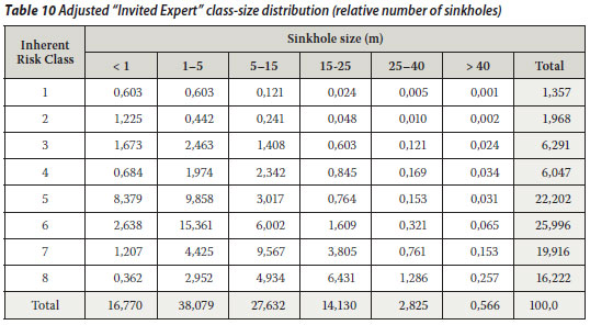
Sinkholes larger than 15 m in diameter were divided into three ranges, namely 15-25, 25-40 and > 40 m, for the purposes of calculating development densities from expression (12). The experience-weighted expert classsize distribution in Table 8 was accordingly adjusted as shown in Table 10. The adjustment entails mainly entries in the 25-40 m size range at 20% of those in the 15-25 m size range, and in the > 40 m range at 20% of those in the 25-40 m range. The entries for the first two classes in the 15-25 m size range were also arbitrarily assessed. The entire table was then normalised to a total number of 100 sinkholes.
The return period for one sinkhole per hectare was derived from the class-size distribution in Table 10 by assuming that the entries, Q, represent the number of sinkholes that occur in 20 years over an area of 5 hectares. The product AN in expression (2) is accordingly equal to 100 ha-yr. The resulting return periods were determined by dividing AN = 100 by the number of entries, Q, as shown in Table 11. A value of 100 for AN gave development densities in line with what the CGS expected, as discussed below.
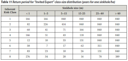
The maximum return period was taken to be 840 years, because the argument of the natural log term in the numerator in expression (12) is negative for longer return periods.
The maximum development densities in terms of the risk of a sinkhole coinciding adversely with a family group were determined for the various Inherent Risk Classes and sinkhole sizes from expression (12), as shown in Table 12 for w = 5 and R = 0,07.

The argument of the natural log term in the numerator in expression (12) is negative for the first two sizes of sinkhole because of the small values for P3 as shown in Table 4. This condition may be dealt with by observing that P2 approaches 1,0 in these instances because of the very large number of houses that are involved. For P2 approaching 1,0, it may be shown from expression (12) that m >18 000 for sinkholes 0 to 2 m in size and m >12 000 for sinkholes 2 to 5 m in size.
The values highlighted in light blue, especially those in the last column, are inaccurate because of the limitation to the return period to 840 years. The values in the various Inherent Risk Classes nevertheless show a minimum turning point character as expected. The minimum values are highlighted in rose. Minimum values cannot be determined for the first two classes because of the uncertainty of the return periods for the size range 15-25 m referred to under Development densities calculated from "Invited Expert" class-size distribution.
The uncertainty referred to is related to a large extent to the relatively small number of sinkholes, especially large ones, that have been recorded for the first two Inherent Risk Classes. Despite this uncertainty, it is commonly accepted that sinkholes in the first two Inherent Risk Classes are relatively unlikely to result in serious injury and to require significant restrictions on development density.
Development densities calculated from Buttrick et al class-size distribution
The class-size distribution in Tables 6 and 9 corresponds exactly to that published by Buttrick et al. It cannot be used to determine development densities as described above for the "Invited Expert" class-size distribution because the corresponding return periods are far too short and the resulting densities far too low. The relative numbers of sinkholes in all the classes in Tables 6 and 9 are represented by two values and in some instances by one value only. A similar lack of variation also applies to the various size ranges. This is the basic reason why the Buttrick et al class-size distribution cannot be used to determine development densities. The problem may be overcome by systematically deploying the Buttrick et al class-size distribution to allow for variation across and down in terms of the geometric series inferred by Buttrick et al, as shown in Table 13. The values shown in light blue correspond to those published by Buttrick et al. The proposed deployment also enables the distribution to be extended to the two largest size ranges.

The return periods for one sinkhole per hectare may be derived from Table 13 by observing that AN is given by Buttrick et al as 20 ha-yr. However, the resulting development densities are more in line with the expectations of the CGS's October 2004 and November 2007 directives by instead adopting a value for AN of 10. The return periods in Table 14 were accordingly determined by dividing AN = 10 ha-yr by the number of entries, Q, in Table 13. The maximum return period was again taken to be 840 years for the reasons given above.

The maximum development densities in terms of a sinkhole coinciding adversely with a family group were determined in the same way as before from expression (12) for the various Inherent Risk Classes and sinkhole sizes. This is shown in Table 15 for w = 5 and R = 0,07.

The development densities for the first two size ranges are respectively >18 000 and >12 000 for the same reasons given under Development densities calculated from "Invited Expert" class-size distribution. The values highlighted in light blue are inaccurate because of the limitation to a return period of 840 years. The values similarly show, in principle, a minimum turning point character, the minimum values being highlighted in rose.
Recommended maximum densities for residential development
The calculated maximum development densities in Tables 12 and 15 are summarised in Table 16. The recommended maximum development densities shown in addition in the table are based on the experiential judgment of the CGS (2004 and 2007).

The recommended development density for Class 2 corresponds very closely to the calculated density based on the Buttrick et al class-size distribution.
The recommended development density for Inherent Risk Class 3 is somewhat less restrictive than the calculated density based on the Buttrick et al class-size distribution because it is relatively easy to design for the maximum size of sinkhole that can readily occur in this class.
The recommended development density for Inherent Risk Class 4 is considerably less restrictive than either of the calculated densities because the maximum size of sinkhole (> 15 m) is less likely to occur since a substantially large volume of water will need to ingress in order to mobilise a large volume of the thick overburden, and if water precautionary measures have been implemented, then such a large leak should be unlikely.
The recommended development density for Class 5 is very similar to the calculated density based on the "Invited Expert" class-size distribution.
The development density (in fact an embargo on development) in Classes 6, 7 and 8 is not really that different from the calculated densities because the relatively small calculated densities are in any event not economical. Overall, the calculated maximum development densities appear to be a sound basis for the recommended densities.
RECOMMENDATIONS
Assumptions are made in the paper on a number of the parameters in arriving at the recommended development densities. It is recommended that the sensitivity of the recommended development densities to the following parameters be investigated.
The probability of sinkhole occurrence is based on the assumption that the class-size distribution of sinkholes represents a T-year phenomenon. The validity of this assumption should be confirmed by comparing the result with that which may be determined on the basis of the geotechnical model for sinkhole formation, presented in principle under Geotechnical modelling of sinkhole development and size.
The Centurion database on the class-size distribution of observed sinkholes could not be used to determine the probability of sinkhole occurrence because the Inherent Risk Class for the area in which the observed sinkholes occurred was not available. It is recommended that this database be expanded by adding the Inherent Risk Class to every entry.
In conclusion, it is recommended that the approach adopted in this paper and the resulting recommended development densities be tested against a wider audience of practising specialists in the field.
This paper is not concerned with mitigation measures to manage the risk on dolomite, which may include issues such as structural design, risk management, management systems and improved wet services system designs. Rather, it focuses attention on the issue of coincidence of residences and sinkholes; research is planned to continue in a similar fashion into the risk exposure of pedestrian and vehicular traffic in dolomite areas that are subject to further densification.
REFERENCES
Buttrick, D B, Van Schalkwyk, A, Kleywegt, R J & Watermeyer, R B 2001. Proposed method for dolomite land hazard and risk assessment in South Africa. Journal of the South African Institution of Civil Engineering, 43(2):27-36, 2001. [ Links ]
South African Council for Geoscience and South African Institution of Engineering and Environmental Geologists and Geologists 2003. Guideline for engineering geological characterization and development of dolomitic land. [ Links ]
South African Council for Geoscience 2004. Approach to residential development on dolomite, October. [ Links ]
South African Council for Geoscience 2007. Consultants' guide: approach to sites on dolomite land, November. [ Links ]
Waltham, A C & Fookes, P G 2003. Engineering classification of karst ground conditions. Quarterly Journal of Engineering Geology & Hydrogeology, Geological Society of London, 36:101-118, 2003. [ Links ]
 | HENDRIK KIRSTEN received all his qualifications in civil engineering from the University of the Witwatersrand. After university, he was a structural design engineer for one year and then spent 8 years teaching at Wits, initially in civil engineering structures, but mainly in mining rock mechanics. He was co-founder and principal of SRK Consulting for 28 years. He has practised independently for the past 8 years. He joined the University of Johannesburg in 2006 and acted as Executive Dean of the Faculty of Engineering and the Built Environment in 2008. He has undertaken over 150 projects and published 80 papers locally and internationally. |
 | GREG HEATH completed his BSc Hons (Engineering Geology) at the University of Pretoria in 1990. He worked for the Council for Geoscience until 1998 where he undertook dam, dolomite and township investigations. He then moved on site to the Matsuko Weir and Tunnel Project (Lesotho) on behalf of SRK Consulting and then to Taiwan where he monitored the construction of two railway tunnels. He is currently employed at the Council for Geoscience where he oversees dolomite research, surveys and report reviews. He has recently submitted his MSc thesis on the location and closure of unsafe mine shafts. |
 | ISAK VENTER is a generalist engineering geologist with 35 years' experience in the subject. He obtained an MSc (Engineering Geology) cum laude from the University of London and DIC Imperial College in 1976 and subsequently worked at the Geological Survey of South Africa, the University of Pretoria and SRK Consulting. He was the Director for Geotechnics and the Environment at Africon from 1987 to 2004. He now works as geotechnical advisor to Africon and the Council for Geoscience, where the focus is on dolomite-related issues. |
 | NICOLE TROLLIP completed her BSc (Hons) and MSc degrees in Engineering and Environmental Geology at the University of Pretoria in 2001 and 2006 respectively. She formed part of the Council for Geoscience Peer Review Team responsible for the review of dolomite stability reports for township establishment and NHBRC enrolment, from 1999 to 2005 as a full-time employee, and continued to do so on a part-time basis until 2007. She is currently in private practice. She has produced two technical papers, conducted numerous site investigations and contributed to the preparation of industry standards since 2001. |
 | THARINA OOSTHUIZEN completed her BSc (Hons) in Engineering and Environmental Geology at the University of Pretoria in 2003. She started her career in the mining environment where she was involved in highwall stability monitoring and exploration until late 2005. After joining the Council for Geoscience, she did some work on foundation investigations for dams and is currently part of the Dolomite Peer Review Team, responsible for reviewing dolomite stability reports. |
 Contact details:
PO Box 17
Fontainebleau, 2032
T 011-782-5861; F 011 -782-0817
hadk@mweb.co.za
Contact details:
Private Bag X112
Pretoria, 0001
T 012-841-1165; F 012-841-1148
gheath@geoscience.org.za
Contact details:
PO Box 36114
Menlo Park 0102
T 082-570-1914; F 012-460-0021;
Isak.Venter@af.aurecongroup.com
Contact details:
PO Box 604
Fourways, 2055, Gauteng
T 011-469-0854; F 011-469-0961/086 689 2847
vgicent@mweb.co.za
Contact details:
Private BagX112
Pretoria, 0001
T 012-841-1160; F 086-615-6682
toosthuizen@geoscience.org.za

