


Serviços Personalizados
Artigo
 Inglês (pdf)
 Artigo em XML
 Referências do artigo
Indicadores

Links relacionados
-
 Citado por Google
 -
 Similares em Google
Compartilhar

 Permalink
Acta Theologica
versão On-line ISSN 2309-9089
versão impressa ISSN 1015-8758
Acta theol. vol.42 no.2 Bloemfontein 2022
http://dx.doi.org/10.18820/23099089/actat.v42i2.22
ARTICLES
Luke for landlubbers: The translation and interpretation of ύττοττλέω in Acts 27
M. Wilson
Research Associate, Department of Ancient and Biblical Studies, University of South Africa. E-mail: markwilson@sevenchurches.org ORCID: https://orcid.org/0000-0002-8536-2718
ABSTRACT
The nautical term ύποπλέω is a hapax legomenon used twice in Acts 27 in the context of Paul's captivity voyage to Rome. This article begins by examining how the word has been translated in verses 4 and 7 in relation to other sailing terms in the chapter. The varying translations, particularly of verse 4, are dependent on the interpretation of the journey's route. Next the depiction of the journey in some Bible atlases is discussed. The atlases typically show two different routes around Cyprus, again dependent on how ύποπλέω is interpreted. The voyages of Herod and Lucian in the north-eastern Mediterranean are also examined for interpretative clues. Mediterranean geography, nautical archaeology, and seafaring praxis will also contribute to a suggested translation and interpretation of the word's uses in this pericope in Acts.
Keywords: Lee, Acts, Ancient sailing
Trefwoorde: Beskutte kant, Handelinge, Antieke seilvaart
1. INTRODUCTION
One might be confused when reading the opening verses of Acts Chapter 27 in a translation such as the English Standard Version. First, most of the readers, who are landlubbers, would not understand the phrase "sailed under the lee" in verses 4 and 7. An explanatory note is helpfully provided for verse 4 - "refers to sailing under shelter; they were protected by the island from the contrary winds" (Grudem 2008:2142). The English glosses and their explanations relate to the Greek word ύποπλέω, which is a hapax legomenon in the New Testament. This hapax must be understood in relationship to other lexically related vocabulary in this pericope encompassing 27:1-44, as well as other nautical terminology used by Luke. Secondly, a look at the map of "Paul's journey to Rome" on the previous page (Grudem 2008:2141) might evoke a question: Why is the route "under the lee" of Cyprus above the island, while the route "under the lee" of Crete is below the island?
This article discusses the background of this sea journey and the issues related to the translations of 27:4 and 27:7 in various English versions. The varying depictions in Bible atlases of Paul's route across the eastern Mediterranean are also presented. The voyages of Herod and Lucian are explored as possible textual comparanda. Finally, nautical archaeology and seafaring praxis will be examined for clues to assist in translating and interpreting this pericope in Acts.
2. NAUTICAL LANGUAGE IN ACTS 27
In this Chapter, Luke employs vocabulary that may have a nautical sense contextually, e.g. επιβαίνω (27:2) and κατάγω (27:3), or a nautical usage exclusively. Regarding the latter, three cognates of ύποπλέω are also used in Chapter 27: αποπλέω meaning to "sail away" or "set sail" (27:1; see 13:4, 14:26, 20:15); πλέω meaning to "sail" (27:2, 6, 24; see 21:3), and διαπλέω meaning to "sail through" or "sail across" (27:5).1 These verbs of motion serve to advance the sailing narrative in this pericope. A synonym of ύποπλέω is used in 27:16 - ύποτρέχω. This verb will be discussed in its own section. The preposition κατά with an accusative object is used four times in verses 2, 5, and 7. Its first usage is in 27:2: εις τους κατά την Άσίαν τόπους is rightly translated as "to the ports along the coast of Asia". In 27:5: τό τε πέλαγος το κατά την Κιλικίαν και Παμφυλίαν διαπλεύσαντες, two actions are suggested. From Cyprus (27:4), the ship crossed the open sea between the island and the coast of Asia Minor; then (τε) it sailed along the coast of Cilicia and Pamphylia. From there, the ship continued to Lycia and arrived at Myra, one of its main ports (κατήλθομεν εις Μύρα της Λυκίας). That the ship was a coasting vessel is implied because it avoided a direct crossing from Paphos to Lycia, with the captain resuming his usual coastal route along the southern coast of Asia Minor. For its two usages in 27:7 - κατά την Κνίδον and κατά Σαλμώνην -English versions translate as "off' or "opposite" Cnidus or Salome. Given the nature of the voyage, "along the coast of Cnidus" and "along the coast at Salmone" are better translations.
3. DEPARTURE FROM CAESAREA MARITIMA
After his appeal to Caesar at the conclusion of a two-year house arrest in Caesarea Maritima, Paul was sent to Rome in the custody of a centurion named Julius along with a pair of guards and a few other prisoners (Acts 26:32-27:2). Roman law allowed a prisoner to be attended by servants. Paul thus brought along a Macedonian believer named Aristarchus. The use of "we" throughout Chapters 27 and 28 suggests that the narrator, traditionally Luke, also travelled with the group.2 Over two years earlier, Aristarchus and Luke as well as six other brothers (in another "we passage") had sailed with Paul on two coasting vessels, first from Troas to Patara, then on to Caesarea (20:4-21:8).3 Besides the captain and crew of perhaps three or four, these nine were probably the highest number of people that such a vessel could accommodate. Similarly, Julius, two guards, Paul, his two friends, and three or four prisoners, as well as crew comprised those on board at their departure from Caesarea Maritima. Regarding transport, Brisco (1998:256) observes:
Paul embarked on a small trading vessel heading to home port at Adramyttium, a city on the northwest coast of Asia Minor.
Adramyttium (Burhaniye, Edremit) was situated at the head of a bay opposite the island of Lesbos. Why Luke chose to include this seemingly insignificant detail is unknown. Paul was acquainted with this area, having passed through it on his second and third journeys to reach Alexandria Troas (Thompson & Wilson 2016:237-240). Coasting vessels conducted cabotage along the Aegean and Mediterranean coasts by trading goods from port to port. As many Mediterranean ports were shallow, only ships with a smaller draft were able to access these harbours (Nantet 2020:5.4.23-25). They also put into port regularly for food and shelter since deck space was limited for cooking and sleeping. This plan is evident in this journey because, after a one-day sail, the ship stopped in Sidon, probably to load goods to carry westward.4
The captain was familiar with the nautical landscape in these waters and had undoubtedly made such a voyage many times.5
Sailing now from Sidon (κάκεϊθεν άναχθέντες), the ship continued past Berytus, Byblos, Tripolis, and Laodicea ad Marum - port cities unnamed in the text, but familiar to Paul from his land travels from Antioch to and from Jerusalem (Acts 11:30, 15:2-3, 18:22; see Gal. 2:1). As the ship turned northwestwards from the coast of Syria, the ship encountered strong adverse winds (δια το τους άνεμους είναι εναντίους; 27:4).6 The Mediterranean Pilot (US Secretary of Navy 1916:40) describes such conditions:
Should the wind, however, veer to northward of west, it will probably go to northwest, from which direction it sometimes, but rarely, blows with such violence.
The ship's captain soon realised that the sea journey between Caesarea Maritima and Adramyttium, a distance of 1,608 kilometres, would take longer than the usual thirteen to fourteen days.7 Some manuscripts of the Western text of 27:5 add "fifteen days" for the journey only from Caesarea to Myra (Metzger 1975:497). The contrary north-westerly winds forced the crew to plot a different course: ύπεττλεύσαμεν την Κύπρον.8 How that new itinerary is translated and depicted is the subject of the next section.
4. Ύποπλέω IN ACTS 27:4
4.1 English translations of the text
The KJV, published when navigation was still powered by wind, translates ύπεπλεύσαμεν την Κύπρον as "we sailed under Cyprus". The NKJV expands: "we sailed under the shelter of Cyprus". While "under" suggests a geographical location below or beneath Cyprus, "shelter" simply means protection from adverse weather. The gloss is thus not helpful geographically. Modern versions such as the NRSV, NIV, ESV, and NET translate as: "[we] passed to the lee of Cyprus". Although "lee" means the sheltered side away from the wind, Barrett (1998:1183) notes the problem:
This is clear, except it does not tell us which is the lee side of Cyprus. This depends on the direction of the prevailing wind.
To clarify what "lee" means, the NLT translates interpretatively as "we sailed north of Cyprus between the island and the mainland". English translations, therefore, present two clear options: below or above Cyprus, either of which could provide a sheltered coastline depending on the wind's direction. Therefore, the vast majority of readers, who are landlubbers, would still be unclear regarding the route.
4.2 Acts 27:4 in Bible atlases
The translation options detailed above are also reflected in the depictions of this sea voyage in Bible atlases. Most of the atlases such as Holman (Brisco 1998:256, Fig. 1), Kregel (Dowley 2004:87), IVP (Lawrence 2006:163), Discovery House (Beck 2015:307, map 11.8), ESV (Currid-Barrett 2010:249, map 12-23), and New Moody (Beitzel 2009:265, map 113) reflect the interpretation of the NLT. They show Paul's ship sailing off the eastern coast of Cyprus before rounding Cape Kleides (modern Apostolos Andreas or Zaferburnu; Fig. 1) at the tip of the Olympic peninsula (modern Karpas).9Beitzel (2009:263) explains that the "lee of Cyprus" is "to the east of Cyprus, in view of the prevailing north-westerly trade winds." The map in the Lexham Geographic Commentary (Fig. 2) reflects the observation of Laney (2019:417):


Since the prevailing winds on the eastern Mediterranean coast during the summer months come from the west, Paul's ship sailed east and north of Cyprus to reach Myra.
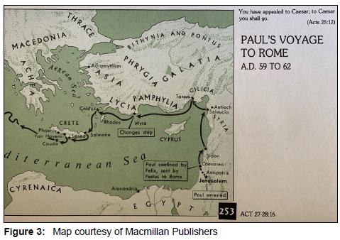
The atlases by Zondervan (Rasmussen 2010:233) and Macmillan (Aharoni & Avi-Yonah 1977:185, map no. 253) show a similar northern passage. However, neither indicates adverse wind conditions, but instead portray a route along the eastern Mediterranean coast. Strangely, the Zondervan Atlas shows a stop at Antioch, while the Macmillan Atlas (Fig. 3) shows stops at both Antioch and Tarsus. Neither are ports situated directly on the Mediterranean: Antioch's port was Seleucia Pieria (Acts 13:4, 14:26), while Tarsus accessed the sea via the Cydnus River. Since both cities were centres of Pauline ministry, Luke would surely have mentioned stops at them.
The maps in the above volumes have been influenced by Thomas Smith's classic volume entitled The voyage and shipwreck of St. Paul. Laney (2019:417, n. 15) specifically mentions Smith as a source.10 Smith's (1866:61) pull-out colour map facing Chapter 1 depicts a route east of Cyprus, then a zigzag course bouncing off the coast of Asia Minor up to Myra. In his discussion of the route, Smith (1866:66-67) notes: "I dissent from the generally-received opinion that they sailed by the south of Cyprus". In developing his opinion, Smith made several assumptions: after leaving Sidon, the ship came in sight of Cyprus; sailing under Cyprus implies that the island was on their left hand, and the open sea, through which they sailed, was the Cilician sea, north of Cyprus. Hence, "they could not have sailed through it without leaving the island on their left" (Smith 1866:68). The captain's goal, according to him, was to reach the Cilician coast to take advantage of the land breezes and the westward currents running along the southern coast of Asia Minor. Smith gives examples of two navigators in his day who sailed this route. However, he fails to note that they sailed from more northerly ports such as Iskenderun and not from Phoenicia farther to the south. In this instance, his nautical comparanda does not parallel the account in Acts.
Only Carta (Rainey-Notley 2006:248), HarperCollins (Pritchard 2010:167), and the Historical atlas of the Bible (Barnes 2010:293) depict a route south of Cyprus. Regarding their portrayal of the voyage, Rainey and Notley (2006:249) write:
The strong headwinds from the northwest prevented the ship from continuing northward along the coast of Syria and Asia. Instead, the crew used the isle of Cyprus to protect the ship from northern winds, and they passed the seacoast of Cilicia and Pamphylia. West of Cyprus the ship turned north, crossed the open seas and arrived at the important Lycian port of Myra.
This description is quoted at length because it has several geographical errors. First, the ship never sailed along the coast of Asia because that province is oriented westwards toward the Aegean Sea. Secondly, the coastline of Cilicia and Pamphylia is never passed on their map (Fig. 4), except at a great distance. If this passage was so negligible, why mention these geographical markers at all? Finally, a coasting vessel typically did not make such a straight run across the open sea to Myra, to be discussed next.

5. Ύποπλέω IN ACTS 27:7
At Andriake, the port of Myra in Lycia (Fig. 5),11 Julius found an Alexandrian grain ship bound for Rome (27:6).12 He arranged for Paul and the other prisoners to trans-ship here. A later tradition holds that Aristarchus left Paul here and continued to Macedonia (John Chrysostom, Homilies on Acts, 53.1).

As the grain ship continued along the southern coast of Asia Minor to its south-western tip at Cnidus (Fig. 6),13 the captain was unable to make sufficient headway into the wind; he thus changed course south-westwards (μη προσεώντος ημάς τοϋ ανέμου; 27:7).

The ship then passed Cape Salmone (modern Sidero) at the north-eastern tip of the island of Crete. Most of the English versions translate ύπεττλεύσαμεν την Κρήτην similarly: "we sailed under the lee of Crete". The NLT expands: "we sailed across to Crete and along the sheltered coast of the island".14 The depiction of this stage of the voyage on every Bible atlas mentioned thus far shows the ship passing below Crete. Despite having the same Greek word in these two verses, they are interpreted and depicted differently.
6. Ύποπλέω IN ACTS 27:16
After leaving the anchorage at Fair Havens under Crete's lee (Fig. 7), the ship failed to reach the harbour of Phoenix for a winter anchorage; it was driven southwards by a typhoon-like storm (27:12-15).

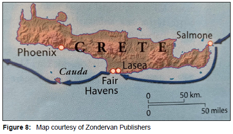
South of Crete is the small island of Cauda (modern Gavdos and Greece's southernmost island). Rather than repeating ύποπλέω a third time to describe the itinerary, Luke dipped into his nautical vocabulary and used the synonym ύποτρέχω: νησίον δέ τι ύποδραμόντες (27:16).15 English translations read that the ship "passed to the lee" (NIV) or "running under the lee" (NRSV, ESV).16The NLT interprets this for landlubbers: "We sailed along the sheltered side". Sailing under Cauda's lee, therefore, provided enough of a respite from the wind for the crew to secure its skiff (σκάφη; not a "lifeboat" as in NIV, NLT). All the aforementioned Bible atlases show the ship passing east and south around this small island comprising only 29.6 square kilometres. The insert map in the Zondervan atlas (Fig. 8; Rasmussen 2010:233) portrays the ship passing first under Crete's lee and then under Cauda's lee. These nautical synonyms, both with the prefix ύπο, are translated and depicted as below the islands rather than above them.
7. OTHER ANCIENT VOYAGES
Prevailing breezes generally dictated the course of ships in the eastern Mediterranean. During the usual sailing season from 10 March to 10 November, the winds blew from the west and northwest (Casson 1971:270273). There are several ancient accounts of voyages in this part of the eastern Mediterranean, two of which will be discussed in this instance.17 In 40 BC, Herod was visiting Alexandria when he learned that a trip to Rome was required. Despite the season being winter (χειμώνας τε όντος), Herod
set sail from there to Pamphylia, and falling into a violent storm (χειμώνι σφοδρω περιπεσών μόλις), he had much ado to escape to Rhodes, with the loss of the ship's burden (Josephus Ant. 14.377; see J.W. 1.280).
Herod's ship, though unstated, was probably a large clipper. Although not yet a king, Herod would undoubtedly secure passage on a vessel commensurate with his wealth and status.18 Nevertheless, even such a large vessel could not sail directly across the Mediterranean but was forced to follow the coastline, as the mention of Pamphylia indicates. Thus, it is remarkable that maps depicting Herod's journey do precisely that: they bypass Pamphylia altogether with a heading west of Cyprus that goes directly to Rhodes.19 However, there is no clue in the text as to whether Herod's ship travelled north or south of Cyprus on its journey. Nevertheless, according to Richardson (1996:127, n. 132),
[t]he account is reminiscent of Paul's trip to Rome; they had to jettison cargo and only barely made it to Rhodes.
In his Navigium (7-9), Lucian tells the story of a massive grain ship named the Isis that left Alexandria between late spring and early fall in approximately AD 150. Casson (1951:137) notes a fundamental fact that "the speed of a sailing ship depends first and foremost on the direction of the wind". A direct route to Rome was not possible because square-rigged vessels cannot sail directly into the prevailing north-west wind. Such ships had to sail seven compass points off the wind. Therefore, the Isis headed north-north-west and passed below Cyprus, the normal route for Alexandrian grain ships. A moderate wind brought it in seven days to Cape Akamas on the island's north-western tip. As the ship turned westwards, a typhonic west wind arose and blew it as far east as Sidon. The captain then turned the ship back northwards to follow the Syrian coast before rounding Cape Kleides on the north-eastern tip of Cyprus, the route typically used by coasting vessels. Using the favourable currents along southern Asia Minor, the Isis arrived at the Chelidonian Islands off Lycia in nine days.20 During this voyage, the Isis used both routes on either side of Cyprus suggested for Paul's ship.21
8. COMMENTATORS ON THE ROUTE
8.1 New Testament scholars
The same divided opinion of the route depicted in biblical atlases is reflected in scholarly comments on Acts 27. In his discussion, Bock (2007:731) introduces this curious remark: "The more common route was by way of Alexandria." No one travelling to Rome, however, from Caesarea Maritima would sail via Alexandria. In fact, as noted from the voyage of Herod, his route to Rome passed by Caesarea rather than the reverse. Bock (2007:732) rightly notes that sailing under the lee of an island means to seek its protection from the westerly and north-westerly winds. He then adds that Paul's ship "would be sailing east and north of the island". He observes that ύποπλέω means to "sail under shelter", but notes that sailing south of Cyprus comprised a route in the open sea, comparing the course to that in 21:1-3. However, those verses record a voyage in the opposite direction with the prevailing wind behind. The comparison, apart from geography, is thus not applicable. Bock mentions the favourable currents along the coast of Asia Minor.22 Interestingly, neither the Mediterranean Pilot nor modern sailing charts describe such a current to aid modern sailors. Bock fails to discuss how the ship could reach this coastline if strong westerly winds were blowing to the north of Cyprus, as mentioned earlier. In this instance, ύποπλέω is interpreted as ύπερπλέω, if that were a Greek word. Discussing 27:7, Bock (2007:733). observes that "the wind prevents them from taking the more normal route across to the island of Cythera, north of Crete". Thus, the ship was forced to sail under the shelter of Crete along its southern coast, causing Bock to interpret ύποπλέω differently in this verse.
Barrett (1998:1184) also opts for a course north of Cyprus
unless the ship had trading connections with Salamis and Paphos, [which] would in any case be the more probable course in an age in which shipping hugged the coastline as far as possible.23
These ports, visited by Paul on his first journey from the landward side (Acts 13:5-6), were not along the probable course.24 Van de Weghe (2019:210) writes:
A ship from Adramyttium sailing for ports along Asia Minor would naturally find shelter to the lee of Cyprus to avoid strong north-westerly winds (Acts 17:1).
While true, this description of the voyage fails to clarify what "lee of Cyprus" means. Campbell (2007:81) is one of the few voices suggesting that the ship charted a course along the southern coast of Cyprus. Nevertheless, regarding the interpretation of "under the lee" in respect of Crete and Cauda, all commentators agree that the ship's route was south of both islands.
8.2 Roman and maritime historians
Casson (1950:46, n. 5) suggests that Paul's ship sailed "left of Cyprus", while Davis (2009:220) observes:
The Adramyttian ship that Paul boarded at Caesarea ... probably shaped a course from Alexandria similar to that intended by Lucian's Isis - to Myra by way of Akamas.
Hohlfelder (2000:246) contrarily suggests that Paul's ship sailed up the Phoenician and Syrian coasts before turning westward to travel along the coast of Cilicia and Pamphylia. He claims that this route was the normal one for smaller vessels travelling east to west, while the larger grain ships used the more direct, open-water route north-westward to the Anatolian coast. Hohlfelder is correct in his assessment but fails to note the important caveat -adverse winds. Murray (1995:39) sustains this view, stating that the Isis sailed north of Cyprus on "essentially the same track followed by Saint Paul when he sailed from Caesarea to Rome in the first century A.D.". Hirschfeld (1990:26), a nautical archaeologist, notes that Paul's ship took a course south of Crete and that the Isis followed a similar path. However, Hirschfeld mentions nothing about the route around Cyprus.
Meijer (2000:76, map 55) has an extended discussion of the route. He observes:
Wanneer we de tekst zo lezen, zonder nadere toelichting, zouden we kunnen denken dat Paulus' schip een westelijke koers voer ten zuiden van Cyprus en vervolgens met het eiland aan stuurboord naar het noorden koerste.25
Meijer opines that the captain might have initially considered following the route of the grain ships south of the island, but because the winds were against him, he manoeuvred along a course on the eastern side of the island. After rounding Cape Andreas, the ship headed to the coast of Cilicia and Pamphylia. Meijer cites the testimony of a French captain De Pagès who, in the early 19th century, attempted to sail from the Syrian coast south of Cyprus but was forced by the winds to make a northern passage around the island. Meijer fails to address why a coasting vessel would leave the Syrian coast and try to follow the route of a grain ship to the south of Cyprus. None of these scholars, however, addresses what ύποπλέω means specifically in Acts 27.
8.3 Nautical archaeology
In his study of anemology, Murray (1995:159) concluded that
we can be reasonably certain that the winds throughout the Mediterranean blew from the same general directions and at the same general times as they do today ... [W]e are fully justified, therefore, in applying modern wind data to the problems of classical antiquity.
He then continues to discuss specifically the winds around Cyprus. For this reason, modern sailing accounts may have heuristic value for recreating ancient sailing routes. 26
In 1965, a shipwreck dating from the Hellenistic period was found north of the harbour of Kyrenia/Girne, Cyprus, on the northern coast (Harpster 2019:6347). Between 1982 and 1985, nautical archaeologists constructed the Kyrenia II with the same tools and techniques used in the original ship. Its first long-distance experimental voyage for scientific purposes sailed from Piraeus to Paphos in 1986, approximately 600 nautical miles in fifteen sailing days and reaching speeds of up to 4.5 knots. Rather than use a coastal route typical in antiquity, Tzalas (2018:242) recounts that the
long, non-stop crossing from Kastellorizo to Paphos was dictated by the fact that political tensions forbade a call in a Turkish port.
In April 1987, the Kyrenia II returned, and Katzev recounts the challenges the crew faced that were similar to Paul's. One day, the ship was becalmed for most of the day and made hardly any progress; another day, they encountered easterly gale winds of eight Beaufort, with gusts over 50 knots. During these high seas, the ship heeled considerably, but, as Katzev (1990:252) notes, "no water came in over her sides, and the hull remained relatively dry". A cargo of 35 empty amphoras overlaying sacks of gravel, representative of what a coasting vessel would haul, did not move in the storm. Tzalas (2018:243) summarises the value of this experiment in nautical archaeology for understanding Paul's voyage:
We have to bear in mind that we are trying to recreate a voyage that was repeated regularly, over and over again, for decades and for centuries.
8.4 Seafaring praxis
Linford Stutzman is a biblical scholar who sails on a boat called SailingActs from its home port in Finike, Turkey. With his wife Janet, they have often sailed the routes in the eastern Mediterranean related to Paul's maritime journeys.27
I have sailed with the Stutzmans on several occasions along the Lycian coast of Mediterranean Turkey. As someone with practical experience sailing the waters discussed in this article, Stutzman provides this informed reflection:
The question of the route between Sidon and Myra is one I've tried to determine as there just are not enough clues in the text. But I do have an opinion based on sailing from Caesarea to Finike in 2006 trying out what I think might be the route. Most maps have the route on the north side of Cyprus, which clearly would be along the coasts of Cilicia and Pamphylia. That would have to assume a southerly wind for the lee to be on the north side of Cyprus - possible but less likely than a northerly. If they had been on the north side, the possibility and likelihood of anchoring at night is much higher and the "open sea" observation (which seems to make it exceptional rather than routine) doesn't make sense.
We tried the southern route ourselves. There was a northerly wind, the lee of Cyprus was on the south side of the island, and the wind was on our right. It was a pretty pleasant sail until the 'open water'. Across this stretch, all the way to Finike, the north wind was moderately strong, but the seas were extremely high indicating very strong north winds the day before. The wind angle could have been just enough for a square-rigged boat to make progress. The fact that the boat was from Adramyttium makes it likely that the captain knew what he was doing for runs from south to north and took the best, maybe the only option. So, my vote is that the lee of Cyprus is on the southern side of the island.28
Stutzman's opinion is sustained in a guidebook for modern sailors: "The Pamphylian and Cilician coasts ... are a coast of passage to Syria or Cyprus, rather than a cruising ground" (Holmes [s.a.]). The reason for this is that there are few harbours and coves along this coastline of 480 kilometres for boats to anchor. If Paul's ship continued to encounter strong north-westerly winds after a stop at Paphos, it probably rode with the wind turned toward the coast of Cilicia to make port at Anamourion (modern Anamur). About this port, the Mediterranean Pilot (US Secretary of Navy 1916:547) states: "There is good anchorage for coasters on the eastern side of the cape during the fresh westerly sea breeze.".29
9. CONCLUSION
This discussion of Luke's use of ύποπλέω in Acts 27:4 and 7 presented the differing translations, interpretations, and depictions regarding the route of Paul's ship sailing in the eastern Mediterranean. These differences are reflected not only in Bible atlases, but also in commentaries and articles on this pericope by both biblical and maritime scholars. The voyages of Herod and the ship Isis in the same region provided insight into the sea routes of large ships travelling to Rome. These Alexandrian grain ships would sail in the open sea south of Cyprus until they reached the coast of Lycia and its two major ports for trans-shipment at Myra/Andriake and Patara. However, coasting vessels typically hugged the Mediterranean coastline as they plied westward to Lycia. This would also be the normal route for the coasting vessel whose home port was Adramyttium. However, the adverse weather encountered by Paul's ship forced a course change, which is outlined next.
After leaving the Syrian coast at Laodicea ad Mare and passing Cape Kleides on north-western Cyprus on its way to Seleucia ad Calycadnum - the nearest port on the Cilician coast - the ship encountered such strong winds that it was forced to retreat "under the lee" of eastern Cyprus, perhaps stopping at Salamis, which Paul visited on his first journey (Acts 13:5). At the headland of Pedalion (modern Cape Greco), the south-eastern point of Cyprus, the ship turned westward and continued "under the lee" of the southern coast past Kition, Amathous, Kourion, and finally Paphos. Rather than sailing directly westwards to Lycia, the coasting vessel then turned northwards and passed Cape Akamas before venturing into the open sea between Cyprus and the Cilician coast. Anamourion is the southernmost point of Asia Minor and only 60 nautical miles/111 kilometres from Akamas, with the two coastlines visible to each other on a clear day. This itinerary is found in the Stadiasmus, or Periplus Maris Magni, 308.30
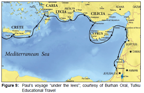
The final Cilician port to the west was Korakasion (modern Alanya). Further along the coast came the Pamphylian port of Side. From Side, the ship would pass across the Pamphylium Mare (modern Gulf of Antalya) to the Lycian port of Phaselis. From Phaselis, it was an easy sail around Cape Chelidonia (modern Gelidonya) to the port of Myra/Andriake, where Paul and his party changed to the Alexandrian grain ship. This grain ship was later forced to sail "under the lee" of Crete, which all scholars agree was on the southern side of the island. The interpretation presented for ύποπλέω in Acts 27:4 is consistent with that of Acts 27:7 and thus understandable to modern landlubbers who read Luke's account. The revised eastern section of Paul's captivity voyage is depicted in this final map (Fig. 9).
BIBLIOGRAPHY
Aharoni, Y. & AVI-YONAH, M. 1977. The Macmillan Bible atlas. New York: Macmillan. [ Links ]
Barnes, I. 2010. Historical atlas of the Bible. Edison, NJ: Chartwell. [ Links ]
Barrett, C.K. 1998. Acts 15-28. London: T&T Clark. [ Links ]
Bauer, W., Arndt, W.F., Gingrich, F.W. & Danker, F.W. 2000. A Greek-English lexicon of the New Testament and other early Christian literature. Chicago: University of Chicago Press. https://doi.org/10.7208/chicago/9780226028958.001.0001 [ Links ]
Beck, J.A. 2015. Discovery House Bible atlas. Grand Rapids, MI: Discovery House. [ Links ]
Beitzel, B.J. 2009. The new Moody atlas of the Bible. Chicago: Moody. [ Links ]
Bock, D.L. 2007. Acts. Grand Rapids, MI: Baker. [ Links ]
Brisco, T.V. 1998. Holman Bible atlas. Nashville, TN: Broadman & Holman. [ Links ]
Bruce, F.F. 1990. The Acts of the Apostles: The Greek text with introduction and commentary. Third revised edition. Grand Rapids, MI: Wm B. Eerdmans. [ Links ]
Campbell, W.S. 2007. The "we" passages in the Acts of the Apostles: The narrator as narrative character. Atlanta, Ga: Society of Biblical Literature. [ Links ]
Casson, L. 1950. The Isis and her voyage. Transactions and Proceedings of the American Philological Association 81:43-56. https://doi.org/10.2307/283568 [ Links ]
Casson, L. 1951. Speed under sail of ancient ships. Transactions and Proceedings of the American Philological Association 82:136-148. https://doi.org/10.2307/283426 [ Links ]
Casson, L. 1971. Ships and seamanship in the ancient world. Baltimore/London: Johns Hopkins University Press. [ Links ]
Cevik, N. 2015. Lykia kitabi. Antalya: Suna & inan Kirap Research Institute on Mediterranean Civilizations. [ Links ]
Chrysostom, J. 400. Homilies on Acts, 53.1. [ Links ]
Currid, J.D. & Barrett, D.P. 2010. ESV Bible atlas. Wheaton, ILL: Crossway. [ Links ]
Curtis, A. 2009. The Oxford Bible atlas. New York: Oxford University Press. [ Links ]
Dando-Collins, S. 2006. Mark Antony's heroes: How the third Gallica legion saved an apostle and made an emperor. Hoboken, NJ: John Wiley. [ Links ]
Davis, C.D. 2020. Analysis of Herod the Great's 40 B.C. voyage to Rome and return. [Online.] Retrieved from: http://theos-sphragis.info/herods_40bc_voyage_analysis.html [22 June 2022]. [ Links ]
Davis, D.L. 2009. Commercial navigation in the Greek and Roman world. Unpublished PhD dissertation. Austin, Texas: University of Texas. http://repositories.lib.utexas.edu/handle/2152/18420. [ Links ]
Dowley, T. (Ed.) 2004. The Kregel Bible atlas. Grand Rapids, MI: Kregel. [ Links ]
Gambash, G. 2017. Between mobility and connectivity in the ancient Mediterranean: Coast-skirting travellers in the southern Levant. In: E.L.Cascio & L.E.Tacoma (eds), The impact of mobility and migration in the Roman empire (Leiden/Boston: Brill), pp. 155-172. https://brill.com/view/title/34002. [ Links ]
Grüdem, W. (Gen. Ed.) 2008. ESV study Bible. Wheaton, ILL: Crossway. [ Links ]
Haenchen, E. 1971. The Acts of the Apostles: A commentary. Philadelphia,Pa : Westminster. [ Links ]
Harpster, M. 2019. Kyrenia shipwreck excavation. In: C. Smith (ed.), Encyclopedia of global archaeology (New York: Springer), pp. 6346-6351. https://doi.org/10.1007/978-3-319-51726-1_3151-2. [ Links ]
Hemer, C.J. 1985. First person narrative in Acts 26-28. Tyndale Bulletin 36:79-109. https://doi.org/10.53751/001c.30571 [ Links ]
Hemer, C.J. 1990. The book of Acts in the setting of Hellenistic history. Winona Lake, IN: Eisenbrauns. [ Links ]
Hirschfeld, N. 1990. The ship of St. Paul: The historical background. Biblical Archaeologist 53:25-30. https://doi.org/10.2307/3210150 [ Links ]
Hohlfelder, R. 2000. Beyond coincidence? Marcus Agrippa and king Herod's harbor. Journal of Near Eastern Studies 59(4):241-253. https://doi.org/10.1086/468859 [ Links ]
Holmes, R. [s.a.]. Sailing east of Antalya. JimB Sail: A cruising guide for European coastlines. [Online.] Retrieved from: https://www.jimbsail.info/mediterranean/turkey/east-of-antalya [19 June 2022]. [ Links ]
Katzev, M.L. 1990. An analysis of the experimental voyages of Kyrenia. Tropis //:245-255. [ Links ]
Keener, C.S. 2015. Acts:An exegetical commentary, 24:1-28:31. Vol. 4. Grand Rapids, MI: Baker. [ Links ]
Kowalski, J.M. 2020. Evolutions of the representation of the eastern Mediterranean in the Hellenistic period. In: E. Nanet (ed.), Sailing from polis to empire: Ships in the eastern Mediterranean during the Hellenistic period (Cambridge: Open Book), pp. 11-25. https://books.openedition.org/obp/14364. https://doi.org/10.11647/OBP.0167.02 [ Links ]
Laney, J.C. 2019. Paul's journey to Rome. In: B.J. Beitzel (ed.), The Lexham geographic commentary on Acts through Revelation (Bellingham, WA: Lexham), pp. 410-429. [ Links ]
Lawrence, P. 2006. The InterVarsity atlas of Bible history. Downers Grove, ILL: InterVarsity. [ Links ]
Liddell, H.G., Scott, R. & Jones, H.S. 1968. A Greek-English lexicon. Oxford: Oxford University Press. [ Links ]
Louw, J.P. & Nida, E.A. 1989. Greek-English lexicon of the New Testament, 2 vols. Second edition. New York: American Bible Society. [ Links ]
Marshall, I.H. 1980. Acts. Grand Rapids, MI: Wm B. Eerdmans. [ Links ]
Meijer, F. 2000. Paulus' zeereis naar Rome: Een reconstructie. Amsterdan: Atheneum -Polak & Van Gennep. [ Links ]
Meinardus, O.F.A. 1979. St. Paul's last journey. New Rochelle, NY: Caratzas Brothers. [ Links ]
Metzger, B.M. 1975. A textual commentary on the Greek New Testament. London/New York: United Bible Societies. [ Links ]
Murray, W.M. 1995. Ancient sailing winds in the Eastern Mediterranean: The case for Cyprus. In: V. Karageorgis & D. Michaelides (ed.), Proceedings of the International Symposium Cyprus and the Sea, Nicosia 25-26 September 1993 (Nicosia: University of Cyprus Press), pp. 33-44. [ Links ]
Nantet, E. 2020. The rise of the tonnage in the Hellenistic period. In: E. Nanet (ed.), Sailing from polis to empire: Ships in the eastern Mediterranean during the Hellenistic period (Cambridge: Open Book), pp. 75-89. http://books.openedition.org/obp/14394.https://doi.org/10.11647/OBP.0167.05 [ Links ]
Orbis 2022. The Stanford geospatial network model of the Roman world. http://orbis.stanford.edu/. [ Links ]
Peterson, D.G. 2009. The Acts of the Apostles. Grand Rapids, MI: Wm B. Eerdmans. [ Links ]
Platon, N. 1992. Zakro. In: J.W. Myers, E.E. Myers & G. Cadogan (ed.), The aerial atlas of ancient Crete (Berkeley/Los Angeles, CA: University of California Press), pp. 292-301. [ Links ]
Polhill, J.B. 1992. Acts. Nashville, TN: Broadman & Holman. [ Links ]
Pritchard, J. (Ed.) 2010. The Harper atlas of the Bible. Revised edition. New York: Harper & Row. [ Links ]
Rainey, A.F. & Notley, S.R. (Ed.) 2006. The sacred bridge: Carta's atlas of the biblical world. Winona Lake, IN: Eisenbrauns. [ Links ]
Rasmussen, C. (Ed.) 2010. Zondervan NIV atlas of the Bible. Grand Rapids, MI: Zondervan. [ Links ]
Richardson, P. 1996. Herod king of the Jews and friend of the Romans. Columbia, SC: University of South Carolina Press. [ Links ]
Sohnabel, E.J. 2012. Acts. Grand Rapids, MI: Zondervan. [ Links ]
Smith, J.A. 1866. The voyage and shipwreck of St. Paul. London: Longmans, Green and Co. [ Links ]
Stutzman, L. 2006. Sailing Acts. Intercourse, PA: Good Books. [ Links ]
Thompson, G.L. & Wilson, M. 2016. The route of Paul's second journey in Asia Minor: In the steps of Robert Jewett and beyond. Tyndale Bulletin 67(2):217-246. https://doi.org/10.53751/001c.29417 [ Links ]
Tzalas, H. 2018. The Kyrenia II, the trireme Olympias, the papyrella: Three different endeavours in nautical experimental archaeology. Archaeonautica 20:239-247. https://doi.org/10.4000/archaeonautica.398. [ Links ]
U.S. Secretary of Navy 1916. Mediterranean Pilot, vol. 4. Washington, DC: Government Printing Office. [Online.] Retrieved from: https://archive.org/details/mediterraneanpi00deptgoog/page/n554/mode/2up [25 April 2022]. [ Links ]
Van de Weghe, L. 2019. Acts 27-28: The cerebral scars of shipwreck. Tyndale Bulletin 70(2):205-220. https://doi.org/10.53751/001c.27722 [ Links ]
Williams, D.L. 1990. Acts. Peabody, MA: Hendrickson. [ Links ]
Wilson, M. 2016a. The Lukan periplus of Saint Paul's third journey with a textual conundrum in Acts 20:15. Acta Theologica 36(1):229-254. http://dx.doi.org/10.4314/actat.v36i1.13. [ Links ]
Wilson, M. 2016b. Saint Paul in Pamphylia: Intention, arrival, departure. Adalya 19:229-250. [ Links ]
Witherington III, B. 1998. The Acts of the Apostles. Grand Rapids, MI: Wm B. Eerdmans. [ Links ]
Date received: 4 July 2022
Date accepted: 20 October 2022
Date published: 14 December 2022
1 These meanings are common to the standard lexicons of the New Testament such as Louw and Nida (1989:#53.1, 7, 11) and Bauer et al. (2000), s.v.
2 Hemer (1985:108) importantly observes: "If the 'we-passages' reflect personal participation, they take us nearer to the historical Paul." Hemer (1985:94-102) details ten observations from the relevant chapters that suggest Luke was a first-hand witness. Gambash (2017:160) demurs: "The details leading towards the shipwreck of Paul ... should be observed closely -not necessarily because they offer an authentic description of a historical event, but because they represent a plausible depiction which would have applied in cases of similar background." The difference between "authentic description" and "plausible depiction" may be too finely drawn, in this instance.
3 Because Secundus was a fellow Thessalonian who accompanied Aristarchus, several witnesses add his name at Acts 27:2 (see Metzger 1975:497).
4 For coasting vessels and cabotage in the ancient Mediterranean, see Gambash (2017:155164) and Wilson (2016a:231-232).
5 A periplus related to such coasting vessels is more fully described in Acts 20:13-21:7 on the third journey return. In this instance, eight ports are listed, wherein the captain of the vessel, homeported in Troas, stopped on his way to Lycia. The vessel to which they transshipped in Patara made additional two stops before arriving at Caesarea Maritima. See Wilson 2016a:231-236.
6 Dando-Collins (2006:191) interestingly calls this "an uneventful journey".
7 This is the estimate generated by the mapping software of Orbis: The Stanford geospatial network model of the Roman world (2022); http://orbis.stanford.edu/, which depicts a route south of Cyprus.
8 The hapax legomenon ύποπλέω is never used in the LXX and has few uses in classical sources. Liddell et al.'s (1968:1892) Greek lexicon indicates its use in Acts only in 27:4, and not in 27:7. The passive usage by Philostratus the Elder (Imagines 2.17) is not relevant: κα] το μεν ύποπλεϊται του ζεύγματος ("and while ships sail under the bridge"; Fairbanks transl.). John Chrysostom (Hom. Acts of the Apostles 53) quotes the verb twice in his discussion of Paul's voyage. His translator writes "under Cyprus" and "under Crete".
9 The Oxford Bible atlas (Curtis 2009:168-169) does not even show the captivity journey to Rome on its map of Paul's journeys.
10 Peterson (2009:683) likewise cites Smith for his comment that the winds "made it necessary to sail on the eastern side of the island". No commentator disputes this; the question is: Where did the ship go next from Cyprus's eastern coast?
11 In this instance, Luke does not name the actual port serving the inland city, unlike Appian (Civil Wars 4.10.82). Another example is Acts 13:13, where Perga is 14 kilometres from the coast and connected by road to its port of Magydos; see Wilson (2016b:237-238).
12 Laney (2019:418) suggests that the large imperial horrea (granary), visible south of the harbour and now housing the Museum of Lycian Civilizations, existed in Paul's day and was enlarged later by Hadrian. This early dating, however, is not sustained by the inscriptional evidence; see Çevik (2015:385-387).
13 Casson (1950:48), noting that grain vessels usually made port at Knidos, thus interprets κατά την Κνίδον as landing there, "as the vessel carrying St. Paul did". However, the prevailing winds seemingly did not permit such a stop.
14 Platon (1992:292) observes that the north winds near the cape "are extremely strong and often veer to the west, making it impossible to round the cape". A Minoan palace was located further along the coast at Zakros, and its bay provided a natural shelter for ships sailing beneath the lee of Salmone. This bay was probably used by the ship's captain to anchor after successfully negotiating the cape.
15 ύποτρέχω is another hapax legomenon and never used in the LXX. Louw and Nida (1989:54.10) list it together with ύποπλέω under the heading "Marine Activities".
16 Liddell et al.'s (1968:1899) Greek lexicon discusses six dimensions of its semantic range, noting Acts 27:16 in the first, suggesting "run under the lee of Bauer et al. (2000:1042) note that it is a nautical term and used by Plutarch (Moralia 243e) to describe the escapees from Troy who, to weather a storm, are forced to "run in" (ύποδραμόντες) to anchorages and havens.
17 Casson (1951:143) lists ten journeys made westward under unfavourable winds. While Lucian's journey is listed, Herod's is not.
18 This content is summarised from Hohlfelder (2000:245-246).
19 Although Davis (2020) repeatedly claims that "[b]oth the outbound and homebound voyages would likely track close to coastlines because of the need to frequently replenish rations for the crew", his maps do not reflect that.
20 This content is summarised from Casson (1950:43-46).
21 For a map of the voyage, see Casson (1950:44).
22 Polhill (1992:516) is another commentator who mentions such currents.
23 Schnabel (2012:1035) further suggests that the original course was along Cyprus' southern coast with Paphos being "the most plausible port of call However, this was the usual course of grain ships, not coasting vessels.
24 Other scholars who adopt a route on the eastern side of Cyprus that turned north to the coast of Asia Minor include Haenchen (1971:698); Bruce (1990:512); Williams (1990:428); Schnabel (2012:1035), and Keener (2015:3579). Scholars, who mention "lee of Cyprus" and seem to suggest a northern route without spelling it out, include Meinardus (1979:66); Marshall (1980:404); Hemer (1990:133), and Witherington (1998:761).
25 English translation: "Reading this text, with no further explanation, we would think Paul's ship sailed in a westerly course south of Cyprus and then with the island at starboard in a northerly direction." I thank Martijn Van Breden for this translation. Meijer's discussion of the course continues on pages 77-78.
26 Meijer (2000:78-82) also uses the experimental voyage of the Kyrenia to inform his discussion.
27 For the story recounting their purchase and reconditioning of their sailboat "SailingActs", along with some accounts related to their sailing voyages, see Stutzman (2006).
28 Personal correspondence dated 2 May 2021. In a previous article published in Acta Theologica (2016:1), I thanked Stutzman for his helpful comments in note 1.
29 The Mediterranean Pilot (US Secretary of Navy 1916:540-547) provides an interesting, detailed description of "Karamania", the coastline of Cilicia, Pamphylia, and Lycia as it was a century ago. The ancient ports are mentioned, but apart from these, few anchorages for coasting vessels are mentioned. This again suggests that the coastline has not changed much.
30 This itinerary is depicted on the map in Kowalski (2020:fig. 2.1). The 700 stadia given in the Stadiasmus is longer than the actual distance.

