


Servicios Personalizados
Articulo
 Inglés (pdf)
 Articulo en XML
 Referencias del artículo
Indicadores

Links relacionados
-
 Citado por Google
 -
 Similares en Google
Compartir

 Permalink
Kronos
versión On-line ISSN 2309-9585
versión impresa ISSN 0259-0190
Kronos vol.38 no.1 Cape Town ene. 2012
ARTICLES
Arteries of empire: on the geographical imagination of South Africa's Railway War, 1914/1915
Giorgio Miescher
Marie Curie Research Fellow, University of Basel and University of the Western Cape
ABSTRACT
This essay analyses a set of visual representations of the South African military campaign into German South West Africa in 1914/1915. This campaign is explored in terms of an imperial expansion and approached through the lens of visuality. Elaborating on an album produced by the Kimberley-based photographer Alfred Duggan-Cronin, and cartoons, photographs, and maps kept in the Transnet Heritage Library in Johannesburg, the article traces the ways in which the visual representation of the war favoured a distinct articulation of an imagined imperial space. The analysis of visualised imaginaries is anchored in an inquiry of materiality, and hence considers the importance of the railway system as the technology, vehicle and medium for a dramatic South African expansion in the region.1
In its January 1915 issue the South African Railways and Harbours Magazine published a cartoon in support of South Africa's military campaign in German South West Africa (Figure 1). The cartoon showed 'father time' at a junction where a 'Briton' and a 'Boer' railway track met to form a single one leading to a distant land, named here 'German West Africa'. In his right hand father time held a little flag bearing the date 1915, and the 'Right!' at the head of the cartoon strengthened the old man's determination.

The cartoon is a contemporary interpretation of the military invasion of Namibia, South Africa's neighbouring colony north of the Orange River and at the time under German imperial rule. In the image's framing the war of conquest emerges as a symbolic act of Union, formally attained in 1910, while still insinuating the freshness of the wounds caused by the South African War.2 South Africa's decision to move its troops into the German colony was made in the wake of the clash between the imperial metropolitan powers, which was first fought in Europe itself. Government and parliament, the latter with an overwhelming majority, decided to comply with London's request for military action on the colonial periphery. The British military's strategic interest was merely to bring under control the Atlantic ports of Luderitz and Swakopmund, both equipped with wireless stations and hence potential threats to their imperial navy.3 In contrast, the South African government preferred a complete occupation of the German territory, thereby foreclosing its vision of long term territorial expansion.4
The military campaign was launched in September 1914, but it was temporarily overshadowed by an internal rebellion led by General Maritz, a veteran from the South African War.5 The campaign's eventual outcome was rather predictable, as two unequal military powers met on the Namibian battle-field.6 And indeed, South Africa would emerge as the successful invader by July 1915. Thus, the conquest of the new territory was part of the establishment and unification of the new South African nation.
The war's narration naturally changes from a Namibian perspective. The war marked the end of imperial Germany's colonial endeavours in southern Africa. While the majority of the African people living in the territory at the time might have welcomed the defeat of the German troops, they generally preferred not to participate in the fighting.7 They could not anticipate that 1915 would inaugurate the beginning of South African rule over their lands and a new colonial era that would last for more than seventy years. The shift in colonial power did not involve a change of flags alone, but had deep structural implications. It changed the colony's legal status and geopolitical position. Namibia moved from being the flagship colonial possession of a distant European metropole, the German motherland, to becoming the hinterland of an emerging imperial power beyond its southern border.8
Let us consider the cartoon once again. The image of the railway tracks leading into a united future bears a strong connotation of progress and modernity. The new South African nation literally penetrated into its colony via its gradually expanding railway system. As an almost nostalgic reminder of an immediate past, the old man with his scythe and hourglass, was invited to join the stream of progress and modernity by turning his path to the railway tracks. We might read in this graphic conjunction of past and present a contemporary concern with integrating a rural agrarian Boer society,9 with its alleged traditionalist orientation, into the project of conquest through modernisation. But railways open up further layers of meaning. Beyond their iconic presence in discourses of modernity and progress, they were the material and tangible vehicle of imperial expansion that transformed vast parts of late nineteenth and early twentieth century worlds.10 This was true in southern Africa as much as in a broader geographical sense. Driven by a dynamic combination of political aspiration, expanding capitalism and technical innovation, a gigantic cluster of iron tracks was laid throughout many parts of the globe in a remarkably short period of time.11 Railways changed the flow of goods and people, the constellation of markets as well as the balance of military power. First built in Europe and the United States, railways likewise played a crucial role in late nineteenth century imperial expansion on the African continent, though the process varied regionally.12
The cartoon published in the South African Railways and Harbours Magazine gained popularity, with some graphic variation in the ways it visually positioned the railway and the old man.13 Powerfully, and it almost seems purposefully, this popular image transformed a military campaign into a mere project of technological and in-frastructural opening and development. Thus, through the visual cleansing a war of conquest became a matter of pure technical operation. What is of particular interest at this point though is that the same cartoon bore in itself the seeds of an imagined geography. From the image emerged a specific vision of an imperial space: unoccupied land into which the railway tracks expanded straightforwardly and purposely, legitimised by the strength of a modern, unified South African power. Yet the vision still drew its validity from its anchorage in very real geopolitics. As a matter of fact, the railway track had its points of origin in Cape Town, Bloemfontein, Pretoria and Johannesburg, i.e. in the South African centres of economic and political power at the time, and it also had its points of destination. The tracks would eventually lead the new colonial power to the mining centres in the coastal town of Luderitz and the northern outpost in Tsumeb, as much as to the colony's political heartland in its capital Windhoek.
What the image concealed was the fact that this territory situated 'beyond the horizon' was anything but an untouched land. On the contrary, German South West Africa had gone through a dramatic transformation in the preceding decade. The genocidal war of 1904-8 and the discovery of huge diamond deposits in the southern Namib Desert in 1908 led to massive public and private investment in the colony. By 1914 the German colony had a modern transport infrastructure with a sophisticated railway system of 2100 kilometres that formed the backbone of the colonial economy in central and southern Namibia.14 The colonial railway system included the private railway of the Otavi Mining and Railway Company (OMEG) which connected the copper and iron-ore mining centre in the north-eastern Otavi region with the coastal town of Swakomund, and the state railway stretching from Luderitz and Kalkfon-tein (today Karasburg) in the south to the capital Windhoek in the central highlands and, again, to the coastal town of Swakopmund.15 In contrast to the narrow-gauge (600 mm) railway of the OMEG, the state railway operated predominately on the so-called Cape gauge of tracks (1067 mm) which was compatible with neighbouring systems such as the South African one.16
Visuality and Space
In recent decades there has been a gradual shift within the discipline of geography away from the positivist conception of space as a given, i.e. as an unmediated empirical reality, towards the idea of space as a socially constructed and mediated category of thought.17 David Harvey's work has been of outstanding importance in this context, and the writings that engaged with his argument gave way to a growing scholarly discussion of what has been termed geographical imagination.18 This shift challenged one of the fundamental certitudes of a discipline which had drawn its methodological legitimacy from the objective and accurate description of the physical and human world. On other grounds, it opened up ways for interdisciplinary dialogue and a stronger affiliation of geography with the humanities. The question of how space is seen, perceived, visualised and mediated came to the fore, and images - graphic, pictorial, and textual - increasingly moved to the centre of analyses.19
More specifically, and of importance to the following discussion, two of the classical forms of geographical representation, maps and photographs, were approached in theoretically broader ways and reconfigured within more nuanced articulations of the disciplinary field. Maps continue to be a key instrument in geographical representations of space and the art of mapping is inextricably linked to geography as a discipline. They consist of coded graphic images which transmit a limited amount of spatial information to the knowledgeable viewer and are as such always a reduced representation of empirical space. J.B. Harley and others have changed our understanding of maps by questioning the supposedly purely technical criteria of this process of visual reduction. Accordingly, maps are now read not only as bearers of mere geographical information, but also as constitutive representations of power relations. Questions of authorship have moved to the fore, as much as awareness of the mutual conditionality of content and omission, message and silence.20
Photography, the second cornerstone of spatial representation, has likewise been revised methodologically and theoretically. Hence, an empiricist approach was abandoned in favour of an inquiry into how photographic images coined the ways in which the world was seen. In view of their vast dissemination within the discipline and in popular representations of space, photographs were important in the creation of imaginative geographies.21 But it is only in recent years that geographers have systematically committed themselves to explore the role of photography as a distinct and pervasive form of image-making and have begun to explore the complex relationship between photographic practice and geographical imagination.22 This allowed them to raise, among other questions, the problem of how the practice of photography influenced the way people came to know the world and situated themselves in space and time.23
The debates sketched above offer valuable insights for, and understanding of, geographical imagination which, as constructed as it might be, always remains rooted in the materiality of space. Here, I simply understand materiality as the physical environment (however constructed) and thus focus on specific material interventions in space such as, for instance, the railway line. My analysis aims to explore these interventions and, subsequently, the way in which they have been imagined and rep-resented.24 By balancing materiality and representation, I hope to anchor the pictorial productions discussed in the contingency of historical time and space.
In what follows I will hence explore the complex relationship between the materiality and visualisation of the railway system during the South African invasion of Namibia. I will ask how imperial space is constructed and appropriated through physical intervention and pictorial representation. Here I will discuss the centrality of the railway during the actual fighting as well as with regard to the long-term integration of the territory. My analysis builds on the discussion of different visuals produced during South African imperial expansion northwards and its immediate aftermath. First I look at a private photo album compiled by the Kimberley-based photographer Alfred Duggan-Cronin, then a set of photographs commissioned by the South African Railways and Harbours, and I conclude with a set of maps published in the South African Railways and Harbour Magazine. While the images considered in this essay differ with respect to genre, context of production and intended audience, in sum they offer a new view of South Africa's invasion of the neighbouring German colony, an event for which I propose the term 'South Africa's railway war'.
Alfred Duggan Cronin's Photo-album on the South West Africa Campaign
In November 2011 I was allowed to enter the store-room of the Duggan-Cronin Gallery in the McGregor Museum in Kimberley where I had the chance to look at the few Namibia related photo albums produced by Alfred Duggan-Cronin.25 My attention was soon drawn to a small, circa A4 sized and slightly worn out album labelled 'DC SWA + EA Campaigns, and I had a first look at the photographs mounted on its pages. Browsing through the album conveyed a strong sense of difference, between the photographic prints in the album and the oversized ethnographic portraits exhibited in the nearby gallery space. In contrast to the album, the gallery showed images that had been widely published and laid the foundation for Duggan-Cronin's popularity and fame.26 Still, my first glimpse at the album remained an encounter without further consequence. Only when I began researching the imperial expansion by the newly founded South African state into its future Namibian colony did I decide to go back to the album kept in Kimberley.
Let us first consider the album as an object and photographic entity. It consists of 62 pages and a total of 161 photographs. The usual design consists of three photographs placed on one page and throughout the album every page's front and back side has been used. Each photograph was glued on a cardboard frame before it was placed into the album and furnished with a handwritten caption. The title of the album is misleading. While the military campaign to Namibia is extensively covered, the campaign to German East Africa, in which Duggan-Cronin was involved immediately after the German capitulation in South West Africa, remains the album's unredeemed promise. The mistake is obviously part of the album's archival trajectory,27 yet it also references the original space of consumption, which was Duggan-Cronin's private environment.
The album as a visual project stems from Duggan-Cronin's participation in the Namibian campaign in 1914 and 1915. Although in his early forties, he volunteered as a low ranking soldier in the 2nd Kimberley regiment and eventually got awarded the '1914-15 Star' for his services by the Union Defence Ministry in 1919.28 By that time, Duggan-Cronin was already well acquainted with photography and it would have been natural for him to take along his camera and cover the course of his regiment's advance to the north.29 Yet eventually, he decided not to reproduce a chronological account of the war, but rather chose a conceptual visual framework. Indeed, the narrative of the album moves back and forth in time and almost randomly through space, therein elaborating on a variety of topics. The photographs show landscapes and places, soldiers of various ranks and in different activities and settings, the technical infrastructure of warfare such as modes of transport from trains to cars, modes of killing from canons to tanks, modes of shelters from trenches to provisional bunkers, and give a glimpse of the local African population. It is, thus, less the choice of the photographic subjects that makes Duggan-Cronin's photographic work exceptional, but rather the way in which he framed these subjects and accordingly composed a narrative in the album.30 In what follows, it is Duggan-Cronin's conceptual exploration, rather than a chronological narration, that will inform my reading and analysis of the album. Firstly, I will give an outline of the album's narrative, and secondly, I discuss the photographic journey along the railway tracks. Then I engage his representations of the newly conquered imperial space. By doing so I am aware that my selection of photographs is inevitably subjective and that different stories based on changing imagery could be told.
The Topography of Duggan-Cronin's Visual Narration
Let me start with a set of photographs from the first few pages, which delineate the contours of the social and geographical spaces in which Alfred Duggan-Cronin's experience, perception and representation of the war materialised.
The photograph entitled 'General Botha at Nonidas, Kilo 6' depicts a group of military men standing next to a gig, a light open coach (Figure 2). The portly figure at the group's centre is General Louis Botha, the then Prime Minister of the Union and Commander-in-Chief of the South African armed forces. Botha had arrived at Swakopmund in February 1915 and personally coordinated the military campaign.31 The photograph, taken at Nonidas just outside the coastal town, occupies a prominent position within the album. It first appears on page two, where it serves as a kind of narrative introduction, and is then reproduced, though in slightly changed framings, on later pages in the album. Within the context of war photography, the images of Louis Botha reference the popular subject of the military leader and commander of troops.32 But while the high ranks in the military often preferred to position themselves in front of the camera and consciously stage their authority and power, Duggan-Cronin's coverage of Botha's appearance and presence on the battle-field was less spectacular. It was a much more distanced view taken by an ordinary soldier, on the margin of the military hierarchy and the politics of the war, and the photographs precisely convey this sense of narrative ambivalence. As we will see, Duggan-Cronin's status as a modest soldier, with limited access to the centres of power and the centre-stage of the war, would inform the entire visual production and narrative arrangement of his photographs.33

Yet there were occasions for closer encounters, for example when Duggan-Cronin's camera interacted with men of comparable status or equal rank. In the photograph entitled 'Motor Launch Otavi' a soldier is comfortably posed in front of a ship attached to a railway carriage (Figure 3).

For whatever reasons, the ship and the military detachment had come to a halt close to an ample building, which both marked the materiality of settler-colonialism and provided an aesthetic backdrop to the photograph. The image was taken at Otavi, a small town and railway junction 500 kilometres from the coast in the Namibian hinterland. But Otavi was, significantly, the place where Duggan-Cronin's regiment was informed about the campaign's completion and the capitulation by the German troops in Otavi's vicinity in July 1915.34 The photograph appears at a very early stage in the album on page three. In conjunction with the images taken around Swakop-mund, this photograph frames the album's geographical space and sketches the radius of Duggan-Cronin's further visual explorations.35
Still, there is a visual and narrative twist here and any observer familiar with the Namibian landscape would have been astonished by the photograph. The image, indeed, produced a disturbing visual and spatial conflation, a concurrent overlapping of time and space, an almost ridiculous material displacement. Otavi's location in the midst of the semi-arid Namibian highlands, at an altitude of around 1400 metres above sea-level with no perennial river or lake in its vicinity, made the presence of a ship unlikely and literally out of place. The ship was a remainder of the German retreat from the coast into the hinterland, once the threat of a South African conquest of the coast had become immediate. For strategic reasons the German military had preferred to remove all the lighters, which had in the past been used to disembark ships at Swakopmund, rather than abandoning them to their invading enemy.36 Duggan-Cronin and his regiment, on the other hand, had pursued the retreating German troops and, eventually, caught up with the ship at Otavi, now turned into a spoil of war.
Why this photograph, then? How could it have made sense within Duggan-Cronin's visual representation of the Namibian occupation? And why, eventually, would he place the photograph of the ship at the opening of his album? If we look at the photographic composition, what emerge as the visual guidelines within the image are the railway tracks and with them, the denotation of a prescribed movement through the landscape. It is, indeed, the presence of the tracks that allow us to translate an otherwise absurd situation - a boat in the middle of an arid savannah - into a narrative of technological advancement that surpassed all reasonable expectation. Through this photograph, in fact, Duggan-Cronin introduced a theme he would rearticulate in changing ways throughout his album, though at this point his notion of the railway as the all-dominant technological device, enabling even the spectacular displacement of a ship, might have been oversubscribed. However named, what the photograph managed to do was to identify the vectors of his and his regiment's trajectory, and thereby frame the specific material anchorage of Duggan-Cronins geographical imagination.
Let us now follow the photographer on his journey along the railway lines and pause, as he does, at the many stations he introduced to his audience. Duggan-Cronin kept an eye on the large locations, the remarkable architectures of railway stations in the main towns, as much as he covered the presence of the many smaller stopping points, with singular buildings, where trains would have been loaded with local farm products and cattle, or where individual passengers might have got on.
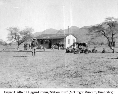
It was indeed these small stations, such as the one depicted in the image entitled 'Station Etiro' on page four, that formed important landmarks, as they added up to an expanding material grid encompassing a vast geographical space (Figure 4). Etiro is situated circa 175 kilometres away from the coast, and the acacia trees around the station building referenced the characteristic landscapes of the highland. Railway stations marked exceptional sites during any journey through central Namibia at the time, as the colony remained sparsely populated and devoid of major residential centres along the way. For train passengers in particular, the stations constituted pivotal temporal and spatial sequences that determined the course and duration of their journey. The soldiers depicted in the photograph, enjoying rest after a strenuous march from the coast towards the interior, re-enacted the privileged site of the railway station where the voyager would find food, water and some relief from the journey's strains in the shade.37 But there is a sense of desertion and abandonment in this photograph, as if the usual industriousness linked to these railway stations, particularly the gathering of animals and people once a train would approach, had disappeared and were now a feature of remoter spaces or but remnants of earlier, more peaceful times.
The three photographs discussed above sketch out Duggan-Cronin's general topography of the South African military occupation of Namibia. It is a visual narrative developed along the railway lines as powerful material inscriptions into the landscape and as the technological arteries of imperial expansion. For this soldier-photographer, positioned on the margins of the military hierarchy and detached from the political centre-stage, the railway emerged as a physical and narrative guideline with distinct temporalities and material configurations of space. It is, as we are told at the album's very beginning, this tension between the logics of the event, a war fought between two imperial adversaries, and the movements and rhythms determined by the gradual advancement of a technological device, which would configure Duggan-Cronin's visual narration of the campaign.
Along the Tracks: The Railway War through a Soldier's Lens
Duggan-Cronin's war experience needs to be understood within the broader military layout of the Namibian campaign.38 On the one hand, the South African forces launched a combined attack on southern Namibia in September 1914: by land the troops crossed the border from the south and from the east, and by sea they occupied the harbour in Luderitz on the Atlantic coast and advanced along the railway line into the interior.39 In the beginning, the South African penetration had slowed down due to the rebellious troops of General Maritz allying with the German forces in the Orange River border region, and their control of the region disrupted the original strategic plans.40 On the other hand, the South African forces soon opened an additional front on the central Namibian coast. Here, British war vessels had bombarded the town of Swakopmund and a first detachment of South African soldiers and engineers began the construction of a coastal railway line in December 1914, linking the British enclave Walvis Bay to the German system.41 In January 1915 the Union forces, including Duggan-Cronin's regiment, occupied the deserted Swakopmund area and started to fight their way eastwards along the railway line the following month. The lines from the coast through the Namib Desert to the interior highlands were soon of utmost strategic importance, both for the attackers and the defenders. Once the South African troops controlled the harbours along the Atlantic, the German colony's main chains of supply had been cut. The strategic conquest of the railway system had hence laid the grounds for a reconfiguration of the military power-play, weakening the German operational functioning and at the same time securing South African carriage of freight, material maintenance and troop logistics.
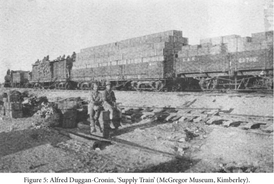
There are a variety of images in the album showing heavily packed trains carrying all sorts of goods, weapons and also troops. This photograph on page 35 illustrates such a case, with a steam locomotive-pulled train with a closed wagon and two heavily loaded open trucks (Figure 5). The photograph's unspecific caption 'Supply Train' refers to the commonness of the situation depicted. Nevertheless, the image itself gives some further information. The lettering SAR and the type of wagons refer to South African Railway rolling stock using the Cape gauge (1067 mm). If we consider the tracks loosely lying around the scene, we can imagine a railway line where the German narrow-gauge tracks were being replaced by the Cape gauge, thus somewhere between Swakopmund and Usakos. The exceptionality of the situation, as a moment of infrastructural transformation, is also marked by the presence of people, probably soldiers, sitting on the roof of the closed wagon, a kind of staging which would not have been possible under normal operational conditions.
Because of its crucial strategic significance, the railway system had become a bone of contention from the very beginning. The German side systematically blew up important railway infrastructure such as bridges. Furthermore, they literally broke up the railway tracks well over fifty kilometres into the interior and brought the railway material into the hinterland.42 The German strategy of destruction entailed that railway construction became a central task for the Union forces.43 And they began, as we saw, with a coastal line between Walvis Bay and Swakopmund, while later gradually rebuilding those tracks that had been broken.
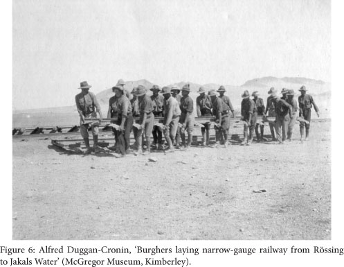
Progress was slow and the climatic and topographic inhospitality of the desert made construction a strenuous endeavour. Sand, wind, heat and cold, the general scarcity of water as well as sudden floods delayed works, and sporadic German attacks, once the construction advanced inland, put lives and infrastructure at great risk. The photograph entitled 'Burghers laying narrow-gauge railway from Rossing to Jakals Water' on page 16 depicts a privileged moment (Figure 6). Most railway construction was, in fact, done by African labourers, but in cases where military intelligence was required, it was exceptionally performed by armed soldiers.44 The involvement of mounted Afrikaner (Burgher) troops was such an occasion and, accordingly, worthy of being captured by Duggan-Cronin's camera.45 The more so as it added to his visual focus on the lower ranks of the troops and, as we shall see, to their continuous presence in his narrative.
But beyond this, manual labour and productive material intervention in space became a realm discursively counter-positioned to, and a target of, military destruction and its lethal apparatuses. The most powerful weapon entering Duggan-Cronin's visual frame was heavy artillery, approached by the camera with ambivalence between captivation and fear.
The photograph 'Naval Gun in action' on page 35 evidenced the photographer's ambivalence in very tangible ways, as much as it referenced teleologies of military industrialisation and modernisation (Figure 7). The canon, more than any other weapon, stood at the threshold of modern warfare with its technological advancements and mechanised operations. The canon visually marked two developments and concerns in military intelligence and warfare: in its basic form it stood for a long history of infantry fighting, and by its increased firepower and target accuracy it embodied technical progress. As part of an ever growing arsenal of modern artillery and heavy machinery, the canon likewise embodied the reconfiguration of the relationship between the human body and the machine.46 Duggan-Cronin seems to have anticipated how the parameters of military conflict would change on the many battlefields of World War I and though the Namibian campaign only met the requirements of modern warfare to some extent, the album sustained a continuous and deeply ambivalent visual negotiation with technological progress.47 The photographer always remained bound to the perspective of the soldier and his intimate experience of fighting and armed confrontation. The photograph above is an image of destruction, of a heavy machine firing into spatial remoteness, while causing terrible heat, smoulder, row and commotion in its immediacy, all of which condensed in a visual blurring and haziness. And it is precisely the canon's reference to a location beyond the frame, to the spatial and temporal dislocation of the bombing that allows the photograph to anticipate war's inevitable actualization - the event of death.

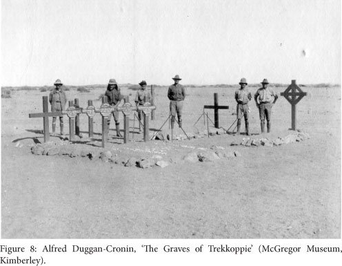
The medium through which the canon photograph enters into conversation with the next image is sound. While 'Naval Gun in action' evoked, as we said, the rumbling of the heavy machine, the metallic charging of the canon, the deafening noise of the discharge and the eventual explosion, the photograph entitled 'The Graves of Trekkoppie' on page 51, in contrast, absorbs the spectacular sound into an all-encompassing silence and a visual voicelessness in view of the dead (Figure 8). But Duggan-Cronin's approach to death remained beyond the immediate spectacle of the event. There is no voyeurism in his photographs, which rather evidence a respectful, humble gaze. There are no images of dead bodies, neither comrades nor enemies, in his album.48 Instead, we encounter a narrative of the graves, such as the one at Trek-koppie (also Trekkopje), a little railway station in the desert. Trekkopje had become a site of heavy fighting where both sides involved in the war suffered casualties and buried their dead on site.49 Here, in contrast to the firing of the canon, the inevitable progress of the war comes to a (dead) halt. The men line up close to their fallen comrades in a graphic correspondence between their upright bodies and the crosses marking the soldiers' last resting site. In many ways, this was a moment of closure, as Duggan-Cronin's regiment was gradually returning to the coast. But while men and machines would beat their slow retreat, restoring the landscape to its pre-war condition, the graves of the soldiers would remain, inscribing themselves as the visible scars of war and continue to mark the landscape long after the war and the resumption of a normalised colonial occupation.50
The New Imperial Space
Once the fighting came to an end, images of conquered land replaced those of military action, although slowly and interruptedly.51 Duggan-Cronin's landscape images read as an expression of his visual curiosity, and he seems to have enjoyed those occasions that led him away from the narrow spaces of the military into the vastness of the country his regiment had helped to conquer. Yet the exploration of the new lands remained within geographies of railway locations and the camera roaming around in the troops' vicinity never transcended the soldier's realm for good. Still, his visual articulation of space becomes persuasive in its complexity and imaginative depth.
The photograph entitled 'Omaruru', on page 28 of the album, stands out for its powerful composition (Figure 9). There is a strong sense of a totalizing vision infusing the way in which the camera framed the scenery and positioned the ample colonial architecture in its centre. This is, indeed, an example of how landscape photography enacted certain notions of power and imperial appropriation of land.52 The photographer's perspective must have been from the top of a solid watchtower overlooking the town of Omaruru, and the view from above favoured the qualification of space in terms of conquest. The vastness of the landscape extending throughout the frame drew from a contemporary iconography of emptiness,53 which could be brought into a balanced visual conversation with the signs of development, marked by the material presence of the building on the edge of the town of Omaruru, the roads and the wagons in the foreground. We enter the space of an imperial frontier and are presented with the fruits of the military occupation, conquered land waiting to be allocated, no more to an invading army but rather to an advancing settler community. And as fierce as the fighting between the antagonist empires had been, as much as the German colonists had been perceived as an enemy of modern governance and social progress under wise imperial guidance, the colonial occupation of land remained common ideological ground.54 It is precisely the reference to this imperial centre-piece, articulated in the photograph by the undamaged building, that conveyed this sense of continuity, though under new auspices.

Let us finally move away from the totalising vision of landscape to the intimacy of the close-up and engage with Duggan-Cronin's most poignant portrait, one of an African man, which I have selected from a rather small group of images of the local population that found its way into the album. Interestingly, there is no photograph of the many thousands of Africans who participated as unarmed labourers, drivers, or in any other position, except as shadowy, barely recognisable bystanders on some of the photographs documenting camp life.55 'A Herero native' on page 23 of the album is probably the most staged and constructed photograph in the Namibian campaign album and it anticipates some of Duggan-Cronin's later aesthetic concerns and politics (Figure 10).

The visuality is indeed quite powerful here and the young man seated on a canister in front of a hut and posing for the camera almost appears in abeyance with himself. We could argue for the photographer's concern with beauty and interpret the image as a powerful obeisance to the physicality and strength of the young male body.56 But there are strong disturbances and ruptures to this aesthetic, and they are most importantly linked to the specificity of the Namibian context - referenced by the Herero label in the caption - and the political economy of South African imperial expansion and colonial occupation. Classified as a 'Herero native', the man in the photograph emerged as a member of the tribalised clientele of the new colonial master, liberated from the cruelty of German tutelage and inaugurated into an era of modern South African colonial governance and guidance. But more significantly, the aesthetics of the strong body, in conjunction with the dirty clothing, and the canister as the material reference to the industrial context, inevitably positioned the young man within a racialised division of labour. While at this point in the album Duggan-Cronin articulated his most pretentious claim to a status as professional photographer with his own aesthetic language, he relegated the man in the photograph to his prescribed role as a labouring subject within the hierarchies of the colonial economy.
My discussion of Duggan-Cronin's album on the South African military campaign in Namibia in 1914/1915 has been concerned with the geographical imagination of the military conquest of Namibia by the photographer. The analysis moved along the railway lines, the central material intervention which determined both the trajectories and rhythms of the campaign as such, as much as it informed the photographer's perception and representation of the Namibian landscape. What emerges throughout the album is a specific articulation of geographical imagination that frames space as a technological appearance, in which the railway system constitutes both a vehicle and idiom of conquest. The geographical imagination so designed reflected the military strategy of South Africa's imperial expansion, an endeavour grounded in the geographies of power predefined by the German settler colony. In fact, the war and eventual change in colonial power concerned the Namibian heartland alone, those parts of the territory which had been configured by the German colonial government as a settler economy based on large-scale expropriation of land and dependent African labour. And the spatial latitude of the territory under German political and economic control had largely been confined to stretches of land along the main transport routes, i.e. roads and, most importantly, railways.57 The specificity of the campaign's spatial regime, anchored in the materiality of the railway system, differed indeed in fundamental ways from South Africa's subsequent military expansion into northern Namibia, beyond the area of colonial settlement and modern transport infrastructure.58
Tracks into New Territory: The Construction of the Prieska-Upington-Kalkfontein Line
The spatial radiation of the war for Namibia went beyond the colony's borders, which leads us back into South Africa. An integral part of the Union's South West Africa campaign entailed the construction of a railway line that would connect the South African system with the one in the German territory. This was not an easy task. The extreme north-western outpost of the South African railway system was Prieska in the northern Cape where a feeder line coming from the important railway junction in De Aar ended. An extension of the Prieska track northwards with the aim to connect the South African with the Namibian system required the new line to cover a distance of 507 kilometres, 372 kilometres to the border and another 135 kilometres to the southern Namibian town of Kalkfontein (today Karasburg).59 Only days after the Union government agreed to join the British war effort the first group of engineers arrived in Prieska on 17 August 1914 to locate, stake out, and make plans for the first stretch of the line, and construction work started two weeks later.60 The effort of thousands of labourers pushed construction ahead as fast as possible. Despite various topographical difficulties, such as the crossing of the Orange River at Upington, and despite military clashes with rebel forces under Maritz, the railway tracks crossed the border on 17 May 1915, and the railway systems were eventually linked up at Kalkfontein on 25 June 1915.61
South African Railways and Harbours prided itself on the fast completion of the new railway line and its crucial role in the South West Africa campaign.62 The successful campaign was celebrated in the company's monthly magazine.63 Some traces of the construction work of 1914-15 are found in the archives of the Transnet Heritage Library which keeps a substantial photographic collection.64 In what follows I will discuss two images from this archive.65
One of the photographs archived in the Transnet Heritage Library documents the progress of construction work (Figure 11).66 The elevated position of the camera allowed for a panoramic view, including both the workers laying the rails in the foreground and the immense open veld (savannah) framed by hills in the background. There is a strong sense of movement in this photograph. The rails in the centre of the image guide the viewer's eye, taking him or her on a steady path into the land. The physical advancement is intensified by the level arm penetrating the image's immediate foreground and the mules entering the frame alongside the tracks.
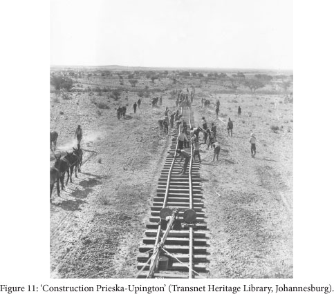
The image captures but a moment during construction work, which eventually lasted for several months. Yet the open frame allows for immanent reference through time and space, producing an endless repetition of action, namely the operation sequence performed by the men.67 First a team of engineers, surveyors and workers had to define the course of the new tracks, accounting for the shortest route, the topographical conditions, ruling grades, curve radii and costs. Once the course of the track was delimited, so called 'earth work gangs' had to clear the bush and build the solid roadbed. The 'earth work gangs' were followed by the 'plate laying gangs' who operated just in front of the railhead loaded with sleepers and tracks. Once unloaded, the sleepers and tracks were carried by mules, keeping the construction material in constant flow. The repetition of these operation sequences and thus the progress of works depended on complex logistics that guaranteed supply of construction material, water and food for the many people and animals involved. Railway construction was a labour intensive endeavour and heavily dependent on African labour. When the work in Prieska began around 1200 men, of whom 1000 were African labourers, had been recruited. The number of African workers soon increased to 2500, and later to 3000 men.68
This photograph echoes an imaginary of space articulated through movement. And it is a very specific kind of movement, one which is grounded in the technology of sleepers and trails, of trains and locomotives. Movement here means penetration, exploration, and appropriation, and it entails a lasting imprint, leaving a physical, permanent mark on the landscape. But the photograph remains hesitant, anticipating a future while at the same time remaining on the threshold. The presence of the draught animals, following the course and pace of the railway's advancement, takes us back to earlier times when moving through the veld was slow and cumbersome. And while in the image past, present and future seem to meet, the advancing tracks bear the promise of acceleration into a modern future. This modernity is given a shape, a presence in the photograph, through the men building the railway tracks. Indeed, the railway authorities responsible for the project prided themselves on their vigorous organisation of labour and its efficient use. The use of artificial light, a remarkable technological innovation at the time, allowed for organisation of 'the plate laying gangs' into three shifts of eight hours, and thereby kept construction work going around the clock. The artificial light literally transformed the outdoor construction site into a factory space.69
This photograph, taken at night, documents the use of artificial light during the railway construction process (Figure 12).70 Technically there was a long open bogie truck at the extreme railhead on which a simple trench with a set of lamps was fixed. The open bogie truck was immediately followed by a covered van containing a dynamo driven by an oil engine. This generator supplied the electricity for illuminating both the actual plate-laying in front of the railhead, and the constant flow of construction material from the wagons behind.71 The men lined up under the floodlight embody the division of labour and the hierarchies in rank, based on a racial order and visualized in the men's clothing and tools. It is precisely the grouping in front of the camera that made hierarchies and labour relations more explicit than in the photograph before. Taken together the two photographs signify a colonial economy of labour; one that was also able to reframe space through modern modes of transport and technology. It is as if the progression of the railway system north-westwards towards the future Namibian colony would carry along with it the compulsory inclusion of the African population into the expanding imperial frontier. Thus, Africans' entrance into the visual frame needed careful orchestration and eventually took the form of recruited labour.72

The Empire's New Tracks - A Conclusion
In December 1915 the South African Railways and Harbour Magazine published a set of four maps that illustrated the growth of the railway network in South Africa. The double page prints depicted the changing network in 1875, 1895, 1905, and 1915.73 The image above, showing the page with the railway system in 1905 and 1915, provides an idea of the visual dynamics in this comparative series (Figure 13). The railway extended over the whole width of the subcontinent, and had spread into the southern African interior almost blurring the image's frame. The self-assured formula 'Railway Progress in South Africa' in the title echoed South Africa's expansionism in the region, which was further enforced by the map's silence on the existence of borders. The thin dotted line marking the threshold to the former German colony signified the residue of an imperial barrier overcome by the war. In an even more ambitious gesture, the map incorporated the British and Portuguese colonies into an imagined South African space, grounded as it was in the railway system.


The visual articulation of such geopolitical aspiration would indeed find quite explicit narrative enforcement, and by 1917 General Jan Smuts ambitiously stated that 'We have started to create a new white base in South Africa, and to-day we are in a position to move forward towards the North and the civilisation of the African continent.'74 Plans to incorporate the German colony north of the Orange River had materialised at a very early stage. Officially, British imperial requirements had been limited to the destruction of the German wireless stations, yet the construction of the railway connecting Prieska and Kalkfontein foreclosed the South African intent for permanent occupation. Correspondingly, the military campaign was conceptualised as a long-term territorial expansion right from its beginning in August 1914. It came as no surprise hence that in the weeks after the campaign had shown success, the South African Railways administration formally took over the former German railway system.75 This material incorporation meant an extension of the South African network by more than 2000 kilometres (1285 miles) in one blow,76 which in the South African government's estimation was worth well over three million pounds.77
This essay has engaged in an exploration of the geographical imagination of South Africa's invasion and occupation of what is today Namibia in 1914/15. I have discussed different visual representations documenting South Africa's imperial expansion ranging from a cartoon and a set of maps in a popular magazine, to a private photo album and a set of commissioned photographs. Because the war for Namibia was fought for, along, and through railway tracks it is best described as 'a railway war'. Engaging with Alfred Duggan-Cronin's album produced in the war's aftermath has enabled me to illustrate one way in which the railway defined the spatial articulation of the war and in which the new territory was imagined. Duggan-Cronin's photographic representation along the tracks was later reformulated in the South African Railways Company's policy to commission photographers and film-makers to document the expanded system, its infrastructure, and, most importantly, all the towns, villages, places and landscapes the railway had made accessible.78 As a result of this policy the company managed to acquire 'quite a representative collection of negatives' in 1922.79 All of these photographic representations materialised during journeys with and along the railway lines, would continue to exercise a profound influence on the constitution of a distinct imperial geographical imagination for years to come. The Prieska-Upington-Kalkfontein (Karasburg) line remains the only railway connection between Namibia and the rest of the continent until today.
1 Earlier versions were presented at the CAS@50 Conference of the Centre for African Studies in Edinburgh, 5-8 June, and the South African Contemporary and Humanities Seminar at the University of the Western Cape, 24 July 2012, where I got valuable critique and comments. I am especially thankful to the discussant at the UWC seminar, Gordon Pirie, the reviewers of Kronos, and Dag Henrichsen for giving me written comments, and to Paul Grendon for making the best out of the images. My special thanks go to Lorena Rizzo for her continuous support of my ongoing work on this essay.
2 See Patricia Hayes, Jeremy Silvester, Marion Wallace and Wolfram Hartman, eds., Namibia under South African Rule. Mobility and Containment 1915-1946 (Oxford/Windhoek/Athens: James Currey/Out of Africa/Ohio University Press, 1998), 4-6.
3 For a contemporary report, see W.S. Rayner and W.W. O'Shaughnessy, How Botha and Smuts Conquered German South West Africa (London: Simpkin, Marshall, Hamilton, Kent & Co., 1916), 7; and for a more recent study, see Gerald LAnge, Urgent Imperial Service. South African Forces in German South West Africa 1914-1915 (Rivonia: Ashanti Publishing, 1991), 7-9.
4 South Africa's main interest in occupying the Namibian territory was twofold. There were, on the one hand, the huge diamond deposits in the south and, on the other hand, the country's potential to accommodate large numbers of South African settlers. See inter alia, Tony Emmett, Popular Resistance and the Roots of Nationalism in Namibia 1915-1966 (Basel: P. Schlettwein Publishing, 1999), 67-69.
5 See LAnge, Urgent Imperial War, 25-58. See also Hermann Giliomee, The Afrikaners. Biography of a People (Cape Town: Tafelberg Publishers, 2003), 379-384.
6 Marion Wallace, A History of Namibia (London: Hurst & Company, 2011), 205-6. There is no accordance in the secondary literature about the rate by which the South African troops outnumbered the German troops. See Marion Wallace, Health, Power, and Politics in Windhoek, Namibia, 1915-1945 (Basel: P. Schlettwein Publishing, 2002), 71, footnote 2. According to Klaus Dierks, Chronologie der Namibischen Geschichte (Windhoek: Namibia Wissenschaftliche Gesellschaft, 2003), the South African troops rose to around 43000 men (177) and the German troops to around 5000 men (171).
7 However, some Namibian Africans did actively participate in the war on the side of the South African troops. See, for example, Wolfgang Werner, No One Will Become Rich': Economy and Society in the Herero Reserves in Namibia, 1915-1946 (Basel: P. Schlettwein Publishing, 1998), 55-57. In at least one case Africans launched an independent armed uprising against the Germans during the South West Africa campaign and a military battle took place at Sam-Khubis near Rehoboth in May 1915. (Dierks, Chronologie, 180).
8 On this argument see also Giorgio Miescher, Namibia's Red Line. The History of a Veterinary and Settlement Border (New York: Palgrave, 2012), 70.
9 See, for example, Giliomee, The Afrikaners, 210-2, 320-3.
10 For a discussion of the complex relationship between imperialism and railways, see Clarence B. Davis and Kenneth E. Wilburn, Jr., with Ronald E. Robinson, Railway Imperialism (Westport: Greenwood Press, 1994). The volume assembles empirical studies focusing on Canada, South Africa, Central Africa, Argentina, Mexico, India, Thailand, Russia and China. For the South African case study, see Kenneth E. Wilburn, Jr., 'Engines of Empire and Independence: Railways in South Africa, 1863-1916' (Railway Imperialism, 25-40). For a more general discussion of railways and empires, see also Robin A. Butlin, Geographies of Empire. European Empires and Colonies c. 1880-1960 (Cambridge: Cambridge University Press, 2009), 471-491 (in the chapter entitled Arteries of Empire', Butlin's title affirms the title chosen for this article).
11 Butlin gives some powerful visual examples for the rapid growth of railway networks. See, for example, the maps illustrating the railway network in India between 1861 and 1901. (Butlin, Geographies of Empire, 473).
12 For a short summary see Butlin, Geographies of Empire, 481-8.
13 See a variation of the cartoon in South African Railways and Harbours Magazine, January 1915, 9. The cartoon shown in this paper was also used, although without discussion, by LAnge, Urgent Imperial Services, 15.
14 For an overview of the economic history of the German colony see Udo Kaulich, Die Geschichte der ehemaligen Kolonie Südwest-Afrika (1884-1914) (Frankfurt a. M.: Peter Lang, 2003). On the development of the railway see the sub-chapter 'Der Eisenbahnbau' (440-462), for the figure of 2100 kilometres see 459.
15 The colonial state bought the OMEG railway in 1910 only to immediately lease it to the very same company. See Kaulich, Die Geschichte, 452-3.
16 The state railway also started as a narrow-gauge railway, such as the first line from Swakopmund to Windhoek. But the lines built after 1904, such as the Luderitz-Keetmanshoop-Windhoek line, were constructed in the broader Cape gauge, and some of the existing lines were succesively adapted. By 1914 all the main lines of the state railway were in the Cape gauge except the stretch between Karibib and Swakopmund. This information was confirmed by Walter Rusch, Namibian railway historian, Windhoek, Personal communication, 11 September 2012. See also Kaulich, Die Geschichte, table on 460, and Dierks, Chronologie, 154, 161, 166.
17 Peter Haggett is one of the most prominent authors of such a positivist and quantitative geography and his introduction to the discipline, Geography: Modern Synthesis first published in 1972 and then followed by numerous re-editions, influenced generations of undergraduate students including myself. For a short introduction to Haggett's work, see Phil Hubbard and Rob Kitchin, eds., Key Thinkers on Space and Place (Los Angeles/London/New Delhi/Singapore/Washington DC: SAGE, 2011 [1st st edition 2004]), 205-210.
18 See David Harvey, 'Between Space and Time: Reflections on the Geographical Imagination', Annals of the Association of American Geographers, 80, 3 (Sept. 1990), 418-434.
19 Here see Denis Cosgrove, Geography and Vision. Seeing, Imagining and Representing the World (London/New York: I.B. Tauris, 2010 [1st edition 2008]), 8.
20 See especially John Brain Harley (edited by Paul Laxton), The New Nature of Maps. Essays in the History of Cartography (Baltimore: John Hopkins University Press, 2002); Jeremy Black, Maps and Politics (London: Reaktion Books, 1997); Ute Schneider, Die Macht der Karten. Eine Geschichte der Kartographie vom Mittelalter bis heute (Darmstadt: Primus Verlag, 2004).
21 The term 'imaginative geographies' became known through Edward Said's famous work Orientalism (London: Routledge and Kegan Paul, 1978).
22 See Joan M. Schwartz and James R. Ryan, eds., Picturing Place. Photography and Geographical Imagination (London/New York: I.B. Tauris, 2009 [1st edition 2003]), especially the editors' introduction 'Photography and the Geographical', 1-18.
23 Ibid., 6.
24 My reading of Harvey's argument remains eclectic here and I do not locate my analysis within the framework of his discussion of geographical historical materialism. (Harvey, 'Between Space and Time').
25 I would like to express my sincere thanks to the Cape Townian artist Andrew Putter (see his photo essay, 'Native Work' in this Special Issue) who was doing research in the gallery at the time and spontaneously invited me into the storeroom without knowing that he facilitated a longer engagement with some of the photographs stored therein. I am also very grateful to the curator of the collection Robert Hart for his generous support of my research on this Duggan-Cronin album.
26 The photographer Duggan-Cronin became famous with a photographic project on the 'native people' of Southern Africa, which was supported by private capital and state institutions. Between 1919 and 1939 he travelled over a hundred thousand kilometres and produced thousands of photographs, which were shown in exhibitions in South Africa and overseas, and which got a most prominent platform when used to illustrate the eleven volumes entitled Bantu Tribes of South Africa that were published by Cambridge University Press. (On this part of Duggan-Cronin photographic oeuvre, see Michael Godby, 'Alfred Martin Duggan Cronin's Photographs for The Bantu Tribes of South Africa (1928-54): The Construction of an Ambiguous Idyll', Kronos: Southern African Histories, 36 (Nov. 2010), 54-83; see also Darren Newbury, Defiant Images. Photography and Apartheid South Africa (Pretoria: Unisa Press, 2009), 15-18; Patricia Hayes, 'Power, Secrecy, Proximity: A Short History of South African Photography', Kronos, 33 (Nov. 2007), 141.
27 The mistake in the title may well have happened during the archival process as the title is not an inherent part of the album, but written with a thick marker on a piece of scotch tape glued on the cover.
28 The McGregor Museum has just a few documents concerning Duggan-Cronin's career as a soldier, one of which is a certificate of a military award dated 27 November 1919.
29 Duggan-Cronin, born in 1874, bought his first camera in 1904 which he soon put to use. (See Godby, 'Duggan Cronin', 2010, 55). It is not known what type of camera Duggan-Cronin took along to Namibia. According to Robert Hart, it was most probably not his Thornton Pickard camera and he probably did not develop the photographs in the field (e-mail communication, Robert Hart, May 2012). For soldiers to take private pictures with their own cameras was not uncommon, but still a rather rare phenomena during World War I, especially when compared to the large scale of private photography by soldiers during World War II. Following the model of the British digital Great War Archive (http://www.oucs.ox.ac.uk/ww1lit/collections/photo), the German National Library and other European archives have recently started to actively trace private memorabilia, including private photographs, amongst the general public (http://idw-online.de/pages/de/news415334). For a short general consideration of private photography in World War I, see for instance Detleff Hoffmann, 'Die zwei Gesichter des Krieges. Offizielle und private Fotografie im ersten Weltkrieg, Photogeschichte, 5 (1982), 21-28; and especially Barbara Duden, 'Der Kodak und der Stellungskrieg. Versuch einer Situierung von Weltkriegsfotografien, BIOS 7 (1994), 64-72.
30 In the photo archive of the Basler Afrika Bibliographien in Switzerland I was able to trace another photo-album with the title 'With the Wits. Rifles in GSWA The album contains some 180 photographs which document the military campaign from a very similar geographical perspective as the one by Duggan-Cronin. Also, the topics are very similar if not basically the same, but the photographs are less multi-layered and the narrative much more chronological. In addition, no indication of the photographers' identities are given. (Album 06, Witwatersrand Rifles, BaslerAfrika Bibliographien, Switzerland).
31 Swakopmund was evacuated months earlier after being shelled by the British navy at the end of September 1914. It was not defended against South African troops approaching from Walvis Bay in January 1915. See Dierks, Chronologie, 172-173; also LAnge, Urgent Imperial Service, 94-95, 138-140.
32 Official photographic documentations of imperial military campaigns inevitably include images of military leaders posing for the camera. For a respective discussion, see James R. Ryan, Picturing Empire. Photography and the Visualisation of the British Empire (London: Reaktion Books, 1997), chapter 3 ('The Art of Campaigning'), 73-98.
33 According to Duden ('Der Kodak', 68), there were almost no restrictions on German soldiers taking private photographs on the European battlefield, whereas the same was strictly prohibited for British soldiers. Duggan-Cronin's photographs suggest that the South African army was less restrictive than the British one, at least on the southern African battlefields. The photographs used for the contemporary photo-album 'With the Wits. Rifles in GSWA' held in the Basler Afrika Bibliographien, mentioned in an earlier footnote, could be ordered by viewers through a printed catalogue. Pages of this catalogue, of which neither the publisher nor the printer is known, are glued into the album. Obviously there was a market for war photographs which supplied former soldiers with memorabilia.
34 The troops were stationed at Otavifontein, two kilometres outside Otavi along the railway tracks to Grootfontein. General Botha also had his headquarters at Otavifontein. Here the last big battle was fought between German and South African forces on 1 June 1915. The German forces officially surrendered eight days later. (Dierks, Chronologie, 181-182; see also LAnge, Urgent Imperial Service, 322-9).
35 A careful examination of all the photographic locations reveals that the photographs on the following 58 pages are also all taken somewhere between the coast and Otavi. I counted twenty-one names of places, almost exclusively railway stops, little stations for water supply, as well as towns along the railway line from the coast into the interior. The names of these railway stops are: Walvis Bay, Swakopmund, Nonidas, Namib, Rossing, Jakalswater, Arandis, Trekkoppie, Karub, Usakos, Etiro, Erongo, Omaruru, Otjtua, Kalkfeld, Okadjande, Otjiwarongo, Otavi, Otavifontein.
36 See Brenda Bravenboer and Walter Rusch, The First Hundred Years of State Railways in Namibia (Windhoek: Transnamib Museum, 1997), 204.
37 The little stations along the railway line functioned as local transport nodal points for goods and people. In addition, they often played an important role for the operation of the railway system which depended on sufficient water supply and regular maintenance of the tracks. Generally, every 50 kilometres there were water supply facilities for the steam engines whereas railway gangs, responsible for maintenance of the tracks, were stationed at even shorter intervals. See, for example, Gordon Pirie, 'Railway Ganging in Southern Africa, c. 1900-37', Journal of Transport History, 14, 1 (March 1993), 64-76.
38 A detailed military history is provided by the South African brigadier-general John Johnston Collyer, The Campaign in German South West Africa 1914-1915 (Pretoria: Government Printer, 1937).
39 On the landing in Luderitz see LAnge, Urgent Imperial Service, 91-96; on the outline of the South African strategy and the first attacks by land see Collyer, The Campaign, 22-34. See also the maps in Collyer, The Campaign, 32, 56. For an account of the over 1100 kilometre march by the 5th S.A.M.R Regiment, from Kimberley along the Kuruman River through the Kalahari Desert to Keetmanshoop, see 'The Firing Line. Active Service with the S.A.M.R. and S.A.P, The Nongquai, 1915, 24-27. The troops left Kimberley on 19 January 1915 and arrived at the German border police station in Hasuur in early April.
40 The first attack by the Union forces into Namibian territory ended in a defeat at Sandfontein north of the Orange River in late September 1914. See LAnge, Urgent Imperial Service, 25-37. On the early period of the Maritz rebellion and his alliance with the German forces, see ibid., 39-58.
41 Dierks, Chronologie, 175.
42 On the breaking up see Bravenboer and Rusch, The First Hundred Years, 204-205, 208-209. There were, in fact, two railway lines connecting the Namibian highlands with Swakopmund, namely the state railway line running from Windhoek via Karibib to Swakopmund and an originally private railway line running from Otavi via Usakos to Swakopmund. The two tracks, both narrow-gauge (600 mm), run almost parallel on the circa 40 kilometres from Rossing to the coast.
43 The task of constructing and running the railway system fell to the specially formed South African Engineer Corps. In addition, all men with railway experience were withdrawn from the various troops to form a special Railway Regiment. The latter comprised a maximum of 1300 men at the height of the campaign. See Bravenboer and Rusch, The First Hundred Years, 206207. See also LAnge, Urgent Imperial Service, 103. For internal and unpublished reports on the campaign by the South African Engineer Corp and the Railway Regiment, see South African Railways and Harbours, Railways. Annual Reports of Departmental Officers, Vol. 2,1915, 206-234 (Transnet Heritage Library).
44 Over 9000 African labourers were employed for railway construction in South West Africa. South African Railways and Harbours, Report of the General Manager of Railways and Harbours for the Year ended 31 December 1915 (Pretoria: Government Printer, 1916), 150.
45 The mounted Afrikaner troops, so-called 'Burgher commandos', played a specific role in the Union's army and the conquest of Namibia. They were organised in the tradition of the small, rather independent 'Boer commandos' in the South African War. These, in military terms unorthodox, commandos did not really fit into the new Union's army organised along British models. However, they played a crucial role due to their large numbers and due to their specific mobile warfare tactic well suited for the Namibian territory. See, for example, Collyer, The Campaign, 11-21; LAnge, Urgent Imperial Service, 191-203. How far this final success of Burgher commandos in South Africa's military history influenced later Afrikaner perception of the newly acquired territory remains to be researched.
46 In discussing a photograph of a South African Defence Force armoured vehicle taken by John Liebenberg in northern Namibia in 1988, Patricia Hayes called this vehicle, a so-called Buffel troop carrier, 'the end product of a long history of military industrialisation'. For her the photograph seems 'to represent the final metamorphosis of human into the machine'. (Patricia Hayes, 'Introduction: Photographs and Ghosts in the War for Namibia' in John Liebenberg and Patricia Hayes, Bush of Ghost. Life and War in Namibia 1986-90 (Cape Town: Umuzi, 2010), 19). In Duggan-Cronin's photograph, in contrast, human and weapon remain, although connected, still two distinct entities.
47 World War I was an experimental field for new technologies of warfare. So was the Namibian battlefield. Duggan-Cronin's photographs document the emergence of two of these previously unseen technologies, namely aircrafts and armoured cars. Air planes were used for aerial reconnaissance by both sides and for aerial bombardments by the German forces. Light-wheeled tanks were shipped from Great Britain and employed by the South African forces. On these technological inventions in Namibia, see for instance the unpublished, but well researched internet article by Golf Dornseif 'Trekkopje: Afrikas erstes Gefecht mit Radpanzern. Tragikomische Aspekte neuer Waffentechnik', www.golf-dornseif.de, accessed 3 May 2012. However, cavalry and horses in general still played a decisive role in the Namibian campaign. According to L'Ange: 'In fact the campaign is seen by some military historians as the last great cavalry operation in military history' (Urgent Imperial Service, 142).
48 The range of photographic documentation taken during World War I, including of mutilated and dead bodies, and its use for specific nationalist or pacifist propaganda in Weimar Germany is discussed for instance in Dora Apel, 'Cultural Battlegrounds: Weimar Photographic Narratives of War', New German Critique: Special Issue on Weimar Visual Culture, 76 (Winter 1999), 49-84.
49 Duggan-Cronin combined on one page of the album a souvenir photo he had shot of a comrade of his unit with the very same man's grave at Trekkoppie. On the skirmish of Trekkopje at the end of April 1915 and its grave sites, see Bravenboer and Rusch, The First Hundred Years, 226-7. The number of casualties during the South West African campaign was low when compared to those on the European battlefields. Nevertheless, 1331 soldiers died on the German side alone during the invasion. (Dierks, Chronologie, 181).
50 Duggan-Cronin could not know that all these dead soldiers would be reburied at the graveyard in Swakopmund in 1918. The crosses that marked the graves at Trekkopje were replaced by standardised thumb stones delivered from South Africa for the Union soldiers and the site became a war memorial (Personal communication, Hasso Gantze, Swakopmund, 7 September 2012). The memorial at Trekkopje can be visited today.
51 Sometimes the caption simply expresses a change of focus from action to landscape. In cases when he had taken two slightly different shots of the same situation, Duggan-Cronin placed the one showing more of the surrounding land in the second part of the album. For example, an image showing a destroyed railway bridge is placed on page 4 and entitled 'Railway Bridge blown up by the Germans at Kalfeld' (should be Kalkfeld), whereas another image showing the very same bridge but from a greater distance and with cattle in the foreground is placed on page 49 and entitled 'View Kal[k]feld'.
52 W.J.T. Mitchell, Landscape and Power (Chicago: University of Chicago Press, 1994). Mitchell has, in the meantime, articulated a certain critique of his original argument. See 'Space, Place and Landscape, the preface to the second edition of Landscape and Power (Chicago: University of Chicago Press, 2002), vii.
53 Here I refer to Jeremy Foster, Washed with Sun. Landscape and the Making of White South Africa (Pittsburgh: University of Pittsburgh Press, 2008), especially chapter 9 'Modernity, Memory, and the South African Railways. The Iconography of Emptiness, 200-237.
54 Wallace, A History, 211-218 [ Links ]
55 According to the small literature on African participation in this war, 33556 Africans served as labourers in the Union Defence Force between August 1914 and August 1915 and, in addition, some were privately engaged by individuals and units. An unknown, but considerably smaller number of 'Coloureds' and 'Indians' were also part of the Union army (W.M. Bisset, 'Unexplored Aspects of South Africa's First World War History', Militaria, 6, 1 (1976), 55-61). Images of African labourers are likewise missing in the photo album 'With the Wits. Rifles in GSWA' in the Basler Afrika Bibliographien mentioned in earlier footnotes.
56 The photograph stages a specific aesthetic which Duggan-Cronin developed further in his photography on Africans. Unlike what Godby noticed in relation to Duggan-Cronin's photographs of Bavenda women ('Duggan Cronin, 71), here the presence of work, expressed in the clothes and shoes of the man, is not denied.
57 I have discussed this elsewhere in detail. See Giorgio Miescher, Namibia's Red Line. The History of a Veterinary and Settlement Border (New York: Palgrave, 2012), especially chapter 2 'The Police Zone Boundary and "Restricted Areas", 1905-1915'.
58 On the expeditions to Owambo, see for instance Patricia Hayes, 'Northern Exposures: The Photography of C.H.L, Hahn, Native Commissioner of Ovamboland 1915-1946' in Wolfram Hartmann, Jeremy Silvester, and Patricia Hayes, eds., The Colonising Camera. Photographs in the Making of Namibian History (Cape Town/Windhoek/Athens: UCT Press/Out of Africa/Ohio University Press, 1998), 171-5. On the expedition to Kaoko, see for instance Lorena Rizzo, Gender and Colonialism. A History of Kaoko (northwestern Namibia), 1870s to 1950s (Basel: Basler Afrika Bibliographien, 2012), especially part II.
59 See E.P. Popkiss, 'Report on Railway Work in Connection with the War and the Rebellion. Prieska-Upington-Nakop-Kalkfontein: Survey and Construction' (n.d.). The fourteen page report was given to the South African Railways by the son of Popkiss in 1967 and is kept in the Transnet Heritage Library.
60 According to Popkiss, the engineers arrived on 14 August and construction work started on 31 August. The Union Parliament officially decided to participate in the war on the side of Great Britain on 9 September 1914. (Rayner and O'Shaughnessy, How Botha and Smuts Conquered German South West Africa, 7).
61 Popkiss, 'Report'.
62 The militarisation of the South African Railways and Harbours during the war is reflected in the military rank of its General Manager William Hoy, who was made Director of the Military Railways in the rank of a Colonel of the Union's army (L'Ange, Urgent Imperial Service, 103). Hoy personally supervised the railway work from the coastal harbours Luderitz and Swakopmund into the interior from April to June 1915 ('Report on South West African Campaign by Lt.-Col. J. M. Fairweather' in South African Railways and Harbours, Railways. Annual Reports of Departmental Officers, Vol. 2 1915, 226-234).
63 See, for instance, South African Railway and Harbour Magazine, June 1915 (568), July 1915 (609), and August 1915 (699).
64 The Transnet Heritage Library, the former South African Railways Heritage Library, holds a collection of some 200000 negatives of photographs alone. Unfortunately, the Heritage Library is not accessible to the public but I was lucky to get at least some access, thanks to the energetic and helpful head of the Transnet Knowledge Centre, Yolanda Meyer, in March 2012.
65 Yolanda Meyer enabled me to trace a good two dozen of photographs documenting the construction of the line although I did not include the ones dealing with the construction of the bridge over the Orange River in this article. I am quite convinced that a more careful search, which was not possible due to the library's closing, would reveal many more photographs.
66 The photograph's title, recorded on the back side, is 'Construction Prieska-Upington. The photographer's name is not known.
67 For a detailed description of the various operational sequences, see Popkiss, 'Report'.
68 Figures given by Popkiss, 'Report'. The number of African labourers specially engaged for the construction of the Prieska-Upington line consisted of 6288 men and for the railway construction in the German colony (including the section Upington-Kalkfontein) 9029 men. These figures do not include the African labourers necessary for the normal operation of railways and harbours. Figures according to South African Railways and Harbours, Report of the General Manager of Railways and Harbours for the Year ended 31 December 1915 (Pretoria, 1916), 150.
69 See Popkiss, 'Report'.
70 On the backside of the photograph we read 'an innovative contraption generating electric power for floodlights to facilitate night working - Prieska'
71 The technique is described in some detail in the report by Popkiss ('Report').
72 Interestingly I could not find an image depicting the African workforce in the visual representations of this railway construction in the popular South African Railways and Harbours Magazine, although these works are well documented in the company's archives.
73 South African Railways and Harbour Magazine, December 1915, 1074-5.
74 The quote is taken from a speech by Smuts, then South African General and later Prime Minister, given in London on 22 May 1917. J. C. Smuts, War-Time Speeches (London/Toronto/New York: Hodder and Stoughton, 1917), 85.
75 The South African Railways administration was officially running the railway in Namibia from 1 August 1915. See National Archives of South Africa, Pretoria, file 'Railways in South West Africa Control. 1915-1922'; SAB-SAS-1073-P12/45 Part I.
76 Figures according to Bravenboer and Rusch, The First Hundred Years, 246.
77 This is according to the report, 'Valuation of South West Africa Protectorate Railways and Harbours' by a South African Commission under Colin Clark, Johannesburg, 15 March 1920 (National Archives of Pretoria, SAB-SAS-1073-P12/45). The Commission's valuation of £ 3,150,675 was probably rather conservative.
78 See, for example, Foster, Washed with Sun, esp. 212-4. The annual report for 1915 by the Manager of the Publicity Department, for instance, carefully notes that 1127 new negatives were added to the stock and that 20525 feet cinematographic film were taken. (See South African Railways and Harbours, Railways. Annual Reports of Departmental Officers, Vol. 2 1915, 143). The circa 200000 photographic negatives stored in the Transnet Heritage Library are the tangible outcome of this photographic demand. (Personal information, Yolanda Meyer, March 2012).
79 Manager Publicity Department to General Manager, 8 November 1923 (National Archives of Pretoria, SAB-SAS-178-G4/4/42). The Heritage Library holds a voluminous undated photo album with photographs depicting South West Africa in the early period of South African occupation.

