


Services on Demand
Article
 English (pdf)
 Article in xml format
 Article references
Indicators

Related links
-
 Cited by Google
 -
 Similars in Google
Share

 Permalink
Koedoe
On-line version ISSN 2071-0771
Print version ISSN 0075-6458
Koedoe vol.62 n.2 Pretoria 2020
http://dx.doi.org/10.4102/koedoe.v62i2.1584
ORIGINAL RESEARCH
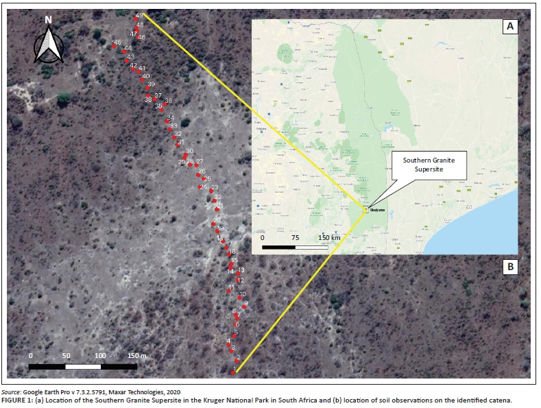
Identification of hydropedological flowpaths in Stevenson-Hamilton catena from soil morphological, chemical and hydraulic properties
Darren Bouwer; Pieter A.L. le Roux; Jacobus J. van Tol
Department of Soil, Crop and Climate Sciences, Faculty of Science and Agriculture, University of the Free State, Bloemfontein, South Africa
ABSTRACT
In highly variable water regimes of semi-arid savannahs, water is the key driving force for biotic and abiotic processes. Understanding and measuring components of the hydrological cycle at landscape scale is however difficult because of the spatiotemporal variation of these processes. Hydropedology is a new interdisciplinary research field aiming to use soil information to conceptualise hydrological processes at different scales. In this study, a hydropedological approach was used to identify key hydrological flowpaths on a granitic catena in the Stevenson-Hamilton Supersite in the Kruger National Park. Soils from 49 plots, spaced 10 m apart along a catena, were classified, and their morphology was interpreted in relation to the dominant hydrological response. Soil samples were taken at 10-cm-depth intervals for chemical and physical analysis to assess the relationship between their expected hydrological behaviour and physiochemical properties. The hydropedological survey indicated that the crest is dominated by freely drained recharge soils where infiltration and vertical drainage are dominant. On the midslope, the underlying bedrock has restricted permeability; this promotes lateral flow at the soil/bedrock interface. On the upper footslope, high clay content soils (sodic) restricts further lateral drainage, resulting in return flow (seepage). Overland flow is dominant on the upper and lower footslope. The valley bottom is occupied by freely drained alluvial soils, which act as a recharge zone. The chemical and physical analyses of soil support the interpretations of the hydropedological interpretation of the soil morphology.
CONSERVATION IMPLICATIONS: Understanding hydrological processes is important for sustainable water resource management, especially in the areas with highly variable water regimes. A hydropedological approach provides an efficient method to characterise dominant flowpaths at landscape scale. This aids the estimation of the hydrological sensitivity of the landscape to climate and land use changes
Keywords: Hillslope; Hydrology; Soil morphology; Semi-arid environments; Hydrological processes; Savanna ecosystems.
Introduction
Soil acts as a first-order control in the portioning of hydrological flowpaths and governing residence periods of water in a landscape. Water, on the other hand, is a primary agent in soil formation and leaves unique soil morphological signatures of water movement and storage. This interactive relationship between soil and water serves as the basis for a relatively new, interdisciplinary field of study called hydropedology (Lin 2010; Lin et al. 2006a). This synergistic research field promotes a more integrated approach to address complex issues regarding water resource management in variable water regimes of semi-arid landscapes (Kutílek & Nielsen 2007; Lin 2003; Lin et al. 2006b). Hydropedological studies at landscape scale typically include various components of the hydrological cycle and recognise the intimate relationship between surface and groundwater at various spatiotemporal scales (Van Tol & Lorentz 2018).
In the recent past, hydropedological studies done on landscape scale in South Africa have focussed on the interpretation of soil morphological properties, and their spatial distribution, in order to derive the hydrological behaviour of hillslopes and catchments (e.g. Van Tol et al. 2010; Kuenene et al. 2013). These qualitative descriptions of the dominant hydrological behaviour were then used to construct conceptual flowpath models that were used in hydrological modelling (Van Zijl et al. 2016) to determine the migration paths of pollutants (Mamera & Van Tol 2018), wetland rehabilitation (Riddell, Lorentz & Kotze 2012) and the impact of land-use changes (e.g. open-cast mining) on water resources (Van Tol et al. 2018). The underlying assumption of these hydrological interpretations of soil morphology is that soil morphological properties are reflecting the current soil-water regime.
The irreversible nature and slow reaction of some soil properties to soil-forming processes (especially climate) and the lack of morphological expression in immature soils question the correctness of interpretations derived from morphological properties alone (Lin et al. 2005). The process of soil formation is relatively long (102-104 years), and soil morphology might, therefore, represent relict environmental conditions (MacEwan & Fitzpatrick 1996). Although there is sufficient evidence that soil morphology correlates well to current soil water regimes in wetter parts of South Africa (e.g. Van Huyssteen et al. 2007; Van Tol et al. 2010), there is still a need to establish these correlations in drier climates.
Soil chemical properties are less buffered to environmental changes than morphological properties (MacEwan 1997). The factors influencing chemical processes are similar to those influencing pedological process (Kutílek & Nielsen 2007), water being the prime mediator of chemical reactions in soils (Essington 2004). Soil chemical properties and their spatial distribution (vertically and laterally) can, therefore, be interpreted to identify hydrological flowpaths (Bouwer et al. 2015) and verify the correctness of interpretations and conceptual models of hydrological behaviour that were derived from soil morphology alone.
This work forms part of a larger interdisciplinary project that focused on the aboveground-belowground ecological patterns and their relationship with granitic catenal processes in the Kruger National Park (KNP). In most arid and semi-arid areas, water is the primary driver of ecological patterns and processes. In this article, we aimed to characterise the dominant hydropedological response of the granite catena using different levels of soil information. The objective was firstly to use soil morphological properties and relate them with soil-forming processes to deduct the dominant hydrological processes in different soils along the catena. Secondly, soil chemical properties and their spatial distribution were interpreted to verify whether the morphological properties in this catena are in sync with the current climate. The last objective was to measure selected hydraulic properties to quantify dominant flow processes and mechanisms.
Methods
Study area
The crest to the midslope is associated with gentle gradients and comprises apedal soils frequented by Terminalia sericea (Riddell et al. 2014). In the lower midslope positions, there is an abrupt transition to sodic duplex soils. Woody vegetation dominates the crest (Combretum apiculatum and Combretum zeyheri), whilst Acacia nilotica dominates the lower slopes and Euclea divinorium is associated with the duplex sodic soils (Smit et al. 2013).
Data collection
As part of a greater study, botanists laid out 49 plots of 10 m2 from the crest of the hillslope to the valley bottom at 10-m intervals. Soil observations were made to refusal using a hand auger in the centre of these plots, effectively creating a 10-m-interval transect. The soils were classified according to the Soil Classification Working Group (SCWG 1991) and the International Union of Soil Sciences Working Group World Reference Base (WRB 2015). The soil properties and their spatial distribution were interpreted and related to their hydropedological significance and reclassified into hydrological soil types (Van Tol & Le Roux 2019).
Analysis
The samples were dried, sieved and analysed according to standard methods (The Non-Affiliated Soil Analysis Work Committee 1990). Samples were analysed for particle distribution using the pipette method and pH (H2O and KCl) with 1:2.5 solution. The soluble and exchangeable cations and cation exchange capacity were determined using NH4OAc solution.
Selected laboratory analyses were presented as average values of the entire profiles for 49 observations as well as the vertical distribution of selected elements for the modal profiles. The S-value was used to express the total content of basic cations (expressed as equivalent values):

and the exchangeable sodium percentage (ESP) was calculated as follows:
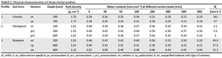
Soil hydraulic properties were determined on three profiles representing diagnostic horizons dominating the upslope, midslope and valley bottom positions. The saturated hydraulic conductivity of each diagnostic horizon in the modal profiles was measured in duplicate using the modified Bouwer and Rice (1976) double-ring falling-head method:

where Ks is the saturated hydraulic conductivity (mm h−1), L is the thickness of the horizon, t is the time until constant infiltration and h0 and h1 are the heads of water above the surface before and after t respectively.
Water retention characteristics were measured for each horizon of the modal profiles on undisturbed core samples. The samples were de-aired at −70 kPa at room temperature for 24 h. Water was then allowed to gradually flow out of the chambers. The saturated samples were mounted on a hanging water column setup in accordance with the procedure shown by Dirksen (1999). The suction levels (h) were set at 0 mm, 38 mm, 50 mm, 100 mm, 200 mm, 400 mm, 600 mm and 800 mm. The gravimetric water content was determined at each level. The samples were then oven-dried at 105 °C to determine the bulk density to calculate the volumetric water content (θv).
Ethical considerations
Ethical approval to conduct the study was obtained from the Interfaculty Animal Ethics Committee of the University of the Free State (reference No. UFS-AED2019/0121).
Results
Soil classification and morphology
Soil chemistry and physical properties
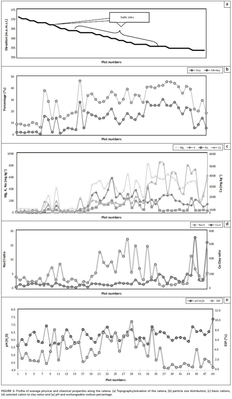
Catenal distribution of soil properties
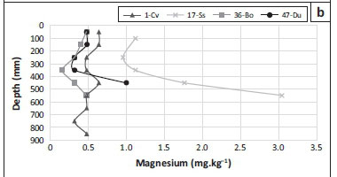
Vertical distribution of properties in modal profiles
The pH ranges from 5.1 in the subsoil of the Clovelly to 7.8 in the pedocutanic horizon of the Bonheim soil (Figure 4b). pH values of the surface horizons are similar for all soil forms in Figure 4(a). All profiles show an initial decline in pH with depth. This decline is more pronounced in the Clovelly soil. The initial decline is followed by an increase in pH of more than 1 and 2 units in the Sterkspruit and the Bonheim soils respectively. The Dundee soil again shows considerable variation because of the nature of alluvial deposits (Figure 4b).
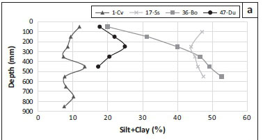

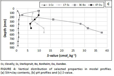
The S-value ranges from 0.48 cmolc.kg−1 in the Clovelly soil to more than 37 cmolc.kg−1 in the pedocutanic horizon of the Bonheim form (Figure 4c). The S-value is relatively constant throughout the Clovelly soil. The S-value decreases drastically from 50 to 150 mm in the Bo soil, from where it increases to the 550 mm layer. In the Sterkspruit soil form, an increase in the S-value with depth is observed whereas the opposite trend is observed in the Dundee soil form (Figure 4c).
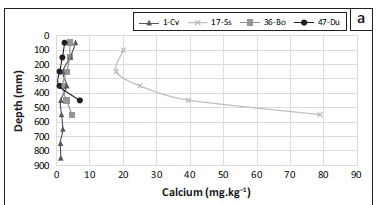
Soluble Na contents range from 1.1 mg kg−1 in surface horizons of the Clovelly to 6.1 mg kg−1 in the subsoil of the Sterkspruit form (Figure 5c). Structured soils (Sterkspruit and Bonheim) generally have higher soluble Na concentrations than the apedal soils. All soils show an increase in Na with depth, although this increase is variable in the Bonheim and Dundee soils.

Hydraulic parameters
Discussion
Hydropedological response based on soil morphology
At the crest and midslope, the soil morphology of the sandy Clovelly and Mispah forms indicates that soil weathering of granitic parent material is the dominant soil-forming process. Horizonisation is visible as yellowing of the B horizon and slight darkening of the orthic horizon because of accumulation of organic matter. The low clay contents indicate that silicate clay, which is formed during weathering of the granite, is eluviated (Figures 3b and 4a). The yellow colour of the Clovelly soils is related to the presence of iron oxides, especially Goethite, which are stable and do not occur in soils saturated for significant periods (Schwertmann 1985). Hydrologically, it implies that a perched water table is not formed in these soils, and deep drainage into the saprolite and fracture rock is the dominant process.
The lateral flowing water continues to accumulate until it reaches the prismatcutanic horizon in the Estcourt soil. Estcourt soils are known for the generation of lateral flow (Van Tol et al. 2013). The prismacutanic horizon acts as a clay plug and governs the lateral flowing water to return to the surface, forming a seepline. The grey colour of the E-horizon of the Estcourt soil further supports this lateral flowpath. The grey colour is the result of removal of iron oxide under reducing (saturated) conditions (Schwertmann 1985; Van Huyssteen et al. 2007). Topsoil erosion, high clay contents and the presence of prismacutanic horizons with strong structure signify that overland flow is the dominant hydrological flowpath in this part of the hillslope. Soil morphology indicates soil formation by clay enrichment due to either, or a combination of, physical (illuviation) or chemical (neo-formation) processes (Owliaie, Abtahi & Heck 2006).
The Bonheim and Milkwood soils of the lower-footslope indicate that weathering is more prominent than in the upper-footslope. Angular blocky structured pedocutanic horizons are in a more advanced stage of weathering than the primary prismatic and secondary angular blocky structures of the prismacutanic soils in the upper-footslopes. The dominant flowpath is still overland flow towards the valley bottom with limited vertical flow. This is expected because of the high clay contents and strong structure of the melanic and pedocutanic horizons. Dundee soils occurring in the valley bottom/riverbed are formed because of alluvial deposits from upstream. The coarse texture of the Dundee soils serves as an area of infiltration and recharge of overland flow from upslope positions as well as during streamflow episodes, that is, the stream is losing water to the groundwater.
The distribution of the soils in the catena indicates four distinctly different zones of soil formation related to different sets of hillslope flowpaths and storage mechanisms. Firstly, soils on the crest indicate soil formation by weathering of granitic parent material with a dominant vertical flowpath recharging the underlying fractured rock. Secondly, in the midslope position, soil morphology indicates subsoil saturation and associated reducing conditions. This results in gleysation and bleaching at the soil/bedrock interface because of removal of iron oxides. The dominant flowpaths are interflow at the soil/bedrock interface which returns to the surface to form a hillslope seep-line. Thirdly, on the footslope, soil morphology indicates soil degradation in the form of water erosion. Overland flow dominates these soils and leaching is subdominant. The strong prismatic structure of the soils of the upper-footslope is an indication that solonisation (accumulation of Na) dominates. In the lower-footslope, the weathering of the prismatic structure into angular blocky structure is because of slightly wetter moisture regimes. Lastly, in the valley bottom, recharge occurs in coarse materials that were deposited during flood events.
Hydropedological response inferred from soil chemical trends
The change in subsoil chemistry from the crest to the valley bottom is correlated to changes in soil types (Figures 2 and 3). Low concentrations of base cations and low pH in the apedal soils at the crest and midslope positions (plots 1 to 7) indicate that eluviation is a dominant process. The almost constant low S-value (Figure 4c) and soluble Ca, Mg and Na cations (Figure 5) at different depths in the Clovelly soil support the deduction made from morphological properties, that is, the vertical flow through and out of these profiles is dominant. Bouwer et al. (2015) found similar trends in freely drained soils in the Weatherley research catchment, South Africa.
At plot 8, there was a marked increase in silt+clay contents and cations associated with the Sterkspruit soil form. The accumulation of cations, especially Ca, suggests that leaching is limited. Significant increase in the Ca:Cl ratio (Figure 3d) signifies the presence of 2:1 clay minerals formed by neo-formation (Wilson 1999).
Very high soluble concentrations of Ca, Mg and Na cations in the subsoil of plot 17 (Ss - Figure 5) suggest that a considerable amount of these cations accumulate in this 'clay plug'. The interpretation is that lateral flow occurs at the soil/bedrock interface from plot 11 to 15, carrying dissolved cations which accumulate in the prismacutanic layer of the Sterkspruit soil form. This supports the morphological interpretation that plots 11 to 15 are interflow soils. Water presumably dams up behind the clay plug and, as water is lost to evapotranspiration (ET), cations accumulate in the soil resulting in an increase in the pH.
Hydraulic property support for the interpretation of morphology and pedochemistry
Conceptual hydropedological response model from morphology, chemistry and hydraulic measurements
1. Infiltration and vertical flow are dominant in the Clovelly soils of the crest position. This is supported by the apedal structure, absence of grey colours, sandy texture, low pH, low base cation concentrations and high Ks values. In the valley bottom, infiltration is also dominant in the streambeds and through coarse alluvial material. Re-infiltration of overland flowing water is likely to occur in the gentle slopes of this terrain position.
2. In this semi-arid environment, evapotranspiration is also dominant (see, for example, Van Tol et al. 2015). A great portion of infiltrated water is likely to evaporate or transpire back into the atmosphere. Evapotranspiration is likely to be high in the valley bottom-associated riparian vegetation.
3. The majority of the hillslope is covered by soils with relatively high clay contents and low hydraulic conductivity. These soils are also characterised by a high base status and pH, which is associated with limited leaching. Overland flow is considered to be the dominant hydrological process. Erosion of surface horizons is additional confirmation that overland flow dominates in the upper- and lower-footslope positions.
4. The presence of hydromorphic B2 horizons suggests that saturated conditions exist during wet periods. Because these hydromorphic signatures become more prominent downslope (up to the start of the sodic site), this is an indication that lateral flow occurs here. This is supported by an increase in soluble base cations in a downslope direction.
5. When this lateral flowing water in (4) reaches the clay-enriched Sterkspruit soils, the water accumulates until the storage capacity of the soils is exceeded and exfiltration in the form of a seepage face takes place. This return flowpath contributes to overland flow.
6. Infiltration into fractures of the granitic parent material (recharge) is possible, although considered a subdominant process in the greater part of this hillslope. On the crest and in the valley bottom, significant recharge could take place during extreme rainfall events.
Conclusion
Terrain morphology is a common representative of homogeneous ecological units in pristine granite landscapes of the Kruger National Park. This catenal effect is an interaction between water, topography and geology as primary components and relates to a hydropedological composition. This composition is both an indication of partitioning and a control factor of movement and storage of water in the catena.
Soil morphology is strongly associated with the hydrological response. The degree to which chemical properties are in sync with current pedological process emphasises the fact that the soils are mature and chemistry and morphology are useful indicators of hydrological response. Chemistry must be interpreted from several observations and with depth, as it responds to the environmental impact within the phase of pedogenesis. Chemical indicators of leaching were used as indicators for flowpaths, although the prediction of flow direction depends on slope and indicators of return flow. The accumulation of cations was an indication of a slow flowpath. Low subsoil pH, and therefore low cation concentration, was used as an indicator of ferrolysis because of periodic saturation. The accumulation of cations in apedal horizons improved morphological interpretation, as the horizons did not respond as fast flowpaths but rather as a storage mechanism induced by the poor drainage of the underlying rock. The chemical properties confirmed the degrading of Sterkspruit to Bonheim soil. The melanic and pedocutanic horizons had chemical trends similar to orthic and prismacutanic horizons, except in lower concentrations. The C horizon of the Bonheim soil has similar chemical properties as those of the prismacutanic horizons.
Pedon scale hydropedology contributed to the understanding of the physical catena and predicted a strong correlation with the biological catena. The use of morphology, chemistry and physics resulted in improving the conceptual understanding of a conceptual model and soil types. Thus, the technique to use soil chemical properties to identify flowpaths in soils has improved the conceptual hydrological models compared to those where only soil morphology was used.
Acknowledgements
Competing interests
The authors declare that they have no financial or personal relationships that may have inappropriately influenced them in writing this article.
Authors' contributions
D.B. and P.A.L. led the research design and conducted fieldwork. D.B. was responsible for lab and data analysis. J.v.T. and D.B. were responsible for data interpretation and the write-up of the article.
Funding information
The authors are grateful to the University of the Free State for funding this multidisciplinary research and the Water Research Commission (WRC) of South Africa under project number K5/2051.
Data availability
Data are available upon request to the corresponding author. Data from all research done within Kruger National Park is placed within the SANParks repository (not for free, open access).
Disclaimer
The views and opinions expressed in this article are those of the authors and do not necessarily reflect the official policy or position of any affiliated agency of the authors.
References
Bouwer, D., Le Roux, P.A., Van Tol, J.J. & Van Huyssteen, C.W., 2015, 'Using ancient and recent soil properties to design a conceptual hydrological response model', Geoderma 241-242, 1-11. https://doi.org/10.1016/j.geoderma.2014.10.002 [ Links ]
Bouwer, H. & Rice, R.C., 1976, 'A slug test for determining hydraulic conductivity of unconfined aquifers with completely or partially penetrating wells', Water Resources Research 12(3), 423-428. https://doi.org/10.1029/WR012i003p00423 [ Links ]
Dippenaar, M.A. & Van Rooy, J.L., 2014, 'Review of engineering, hydrogeological and vadose zone hydrological aspects of the Lanseria gneiss, Goudplaats-Hout river gneiss and Nelspruit suite granite (South Africa)', Journal of African Earth Sciences 91, 12-31. https://doi.org/10.1016/j.jafrearsci.2013.11.019 [ Links ]
Dirksen, C., 1999, Soil physics measurements, Catena Verlag, Reiskirchen. [ Links ]
Essington, M.E., 2004, Soil and water chemistry: An integrative approach, CRC Press, New York, NY. [ Links ]
International Union of Soil Sciences Working Group World Reference Base (WRB), 2015, World reference base for soil resources 2014: International soil classification system for naming soils and creating legends for soil maps, World soil resources reports no. 106, Food and Agriculture Organization of the United Nations, Rome. [ Links ]
Kuenene B.T., Le Roux P.A.L., Van Huyssteen C.W. & Hensley M., 2013, 'Selected soil properties as indicators of soil water regime in the Cathedral peak VI catchment of KwaZulu-Natal, South Africa', South African Journal of Plant & Soil 30(1), 1-6. https://doi.org/10.1080/02571862.2013.767387 [ Links ]
Kutílek, M., 2004, 'Soil hydraulic properties as related to soil structure', Soil Tillage Research 79(2), 175-184. https://doi.org/10.1016/j.still.2004.07.006 [ Links ]
Kutílek, M. & Nielsen, D.R., 2007, 'Interdisciplinarity of hydropedology', Geoderma 138(3-4), 252-260. https://doi.org/10.1016/j.geoderma.2006.11.015 [ Links ]
Leeds-Harrison, P.B., Shipway, C.J.P., Jarvus, N.J. & Youngs, E.G., 2007, 'The influence of soil macroporosity on water retention, transmission and drainage in a clay soil', Soil Use and Management 2(2), 47-50. https://doi.org/10.1111/j.1475-2743.1986.tb00678.x [ Links ]
Lin, H.S., 2003, 'Hydropedology: Bridging disciplines, scales, and data', Vadose Zone Journal 2(1), 1-11. https://doi.org/10.2136/vzj2003.1000 [ Links ]
Lin, H.S., 2010, 'Earth's critical zone and hydropedology: Concepts, characteristics, and advances', Hydrology and Earth System Sciences 14(1), 25-45. https://doi.org/10.5194/hess-14-25-2010 [ Links ]
Lin, H.S., Bouma, J., Pachepsky, Y., Western, A.W., Thompson, J., Van Genuchten, R. et al., 2006a, 'Hydropedology: Synergistic integration of pedology and hydrology', Water Resources Research 42(5), 1-13. https://doi.org/10.1029/2005WR004085 [ Links ]
Lin, H.S., Kogelmann, W., Walker, C. & Bruns, M.A., 2006b, 'Soil moisture patterns in a forested catchment: A hydropedological perspective', Geoderma 131(3-4), 345-368. https://doi.org/10.1016/j.geoderma.2005.03.013 [ Links ]
Lin, H.S., Wheeler, D., Bell, J.C. & Wilding, L.P., 2005, 'Assessment of soil spatial variability at multiple scales', Ecological Modelling 182(3-4), 271-290. https://doi.org/10.1016/j.ecolmodel.2004.04.006 [ Links ]
MacEwan, R.J., 1997, 'Soil quality indicators: Pedological aspects', in E.G. Gregorich & M.R. Carter (eds.), Soil quality for crop production and ecosystem health, pp. 143-166, Elsevier, New York, NY. [ Links ]
MacEwan, R.J. & Fitzpatrick, R.W., 1996, 'The pedological context for assessment of soil quality', in R.J. MacEwan & M.R. Carter (eds.), Soil quality is in the hands of the land manager. Proceedings of an international symposium on advances in soil quality for land management: Science, practice and policy, pp. 10-16, University of Ballarat, Ballarat. [ Links ]
Mamera, M. & Van Tol, J.J., 2018, 'Application of hydropedological information to conceptualise pollution migration from dry sanitation systems in the Ntabelanga area, South Africa', Air, Soil and Water Research 11, 1-12. https://doi.org/10.1177/1178622118795485. [ Links ]
Owliaie, H.R., Abtahi, A. & Heck, R.J., 2006, 'Pedogenesis and clay mineralogical investigation of soils formed on gypsiferous and calcareous materials, on a transect, south-western Iran', Geoderma 134(1-2), 62-81. https://doi.org/10.1016/j.geoderma.2005.08.015 [ Links ]
Riddell, E.S., Lorentz, S.A. & Kotze, D.C., 2012, 'The hydrodynamic response of a semi-arid headwater wetland to technical rehabilitation interventions', Water SA 38(1), 55-66. https://doi.org/10.4314/wsa.v38i1.8 [ Links ]
Riddell, E.S., Nel, J., Fundisi, D., Jumbi, F., Van Niekerk, A. & Lorentz, S., 2014, Ephemeral hydrological processes in savannas, Water Research Commission report no. TT619/14, Water Research Commission, Pretoria. [ Links ]
Robb, L.J., Brandl, G., Anhaeusser, C.R. & Poujol, M., 2006, 'Archaean granitoid intrusions', in M.R. Johnson, C.R. Annhaeusser & R.J. Thomas (eds.), The geology of South Africa, pp. 57-94, Geological Society of South Africa, Johannesburg. [ Links ]
Schwertmann, U., 1985, 'The effect of pedogenic environments on iron oxide minerals', Advances in Soil Science 1, 171-200. https://doi.org/10.1007/978-1-4612-5046-3_5 [ Links ]
Smit, I.P.J., Riddell, E.S., Cullum, C. & Petersen, R., 2013. 'Kruger National Park research supersites: Establishing long-term research sites for cross-disciplinary, multiscaled learning', Koedoe 55(1), Art. #1107, 7 pages. https://doi.org/10.4102/koedoe.v55i1.1107 [ Links ]
Soil Classification Working Group (SCWG), 1991, Soil classification: A taxonomic system for South Africa, Department of Agricultural Development, Pretoria. [ Links ]
The Non-Affiliated Soil Analysis Work Committee, 1990, Handbook of standard soil testing methods for advisory purposes, Soil Science Society of South Africa, Bloemfontein. [ Links ]
Van Huyssteen C.W., Le Roux P.A.L., Hensley M. & Zere T.B., 2007, 'Duration of water saturation in selected soils of Weatherley, South Africa', South African Journal of Plant & Soil 24(3), 152-160. https://doi.org/10.1080/02571862.2007.10634799 [ Links ]
Van Tol, J.J., Hensley, M. & Le Roux, P.A., 2013, 'Pedological criteria for estimating the importance of subsurface lateral flow in E horizons in South African soils', Water SA 39(1), 47-56. https://doi.org/10.4314/wsa.v39i1.7 [ Links ]
Van Tol, J.J. & Le Roux, P.A.L., 2019, 'Hydropedological grouping of South African soil forms', South African Journal of Plant and Soil. 36(3), 233-235. https://doi.org/10.1080/02571862.2018.1537012. [ Links ]
Van Tol, J.J., Le Roux, P.A., Lorentz, S.A. & Hensley, M., 2010, 'Soil as indicator of hillslope hydrological behaviour in the Weatherley catchment, Eastern Cape, South Africa', Water SA 36(5), 513-520. https://doi.org/10.4314/wsa.v36i5.61985 [ Links ]
Van Tol, J.J. & Lorentz, S.A., 2018, 'Hydropedological interpretation of soil distribution patterns to characterise groundwater/surface-water interactions', Vadose Zone Journal 17(1), 1-13. https://doi.org/10.2136/vzj2017.05.0097 [ Links ]
Van Tol, J.J., Lorentz, S.A., Van Zijl, G.M. & Le Roux, P.A.L., 2018, 'The contribution of hydropedological assessments to the availability and sustainable water, for all (SDG#6)', in R. Lal, R. Horn & T. Kosaki (eds.), Soil and sustainable development goals, pp. 102-117, Catena-Schweizerbart, Stuttgart. [ Links ]
Van Tol, J.J., Van Zijl, G.M., Riddell, E.S. & Fundisi, D., 2015, 'Application of hydropedological insights in hydrological modelling of the Stevenson Hamilton Research Supersite, Kruger National Park, South Africa', WaterSA 41(4), 525-533. https://doi.org/10.4314/wsa.v41i4.12 [ Links ]
Van Zijl, G.M., Van Tol, J.J. & Riddell, E.S., 2016, 'Digital mapping for hydrological modelling', in G. Zhang, D. Brus, F. Liu, X. Song & P. Lagacherie (eds.), Digital soil mapping across paradigms, scales and boundaries, pp. 115-129, Springer, Singapore. [ Links ]
Vepraskas, M., Huffman, R.L. & Kreiser, G.S., 2006, 'Hydrologic models for altered landscapes', Geoderma 131(3-4), 287-298. https://doi.org/10.1016/j.geoderma.2005.03.010 [ Links ]
Wilson, M.J., 1999, 'The origin and formation of clay minerals in soils: Past, present and future perspectives', Clay Minerals 34(1), 7-25. https://doi.org/10.1180/000985599545957 [ Links ]
 Correspondence:
Johan van Tol
vantoljj@ufs.ac.za
Received: 30 Aug. 2019
Accepted: 05 May 2020
Published: 29 Oct. 2020

