


Serviços Personalizados
Artigo
 Inglês (pdf)
 Artigo em XML
 Referências do artigo
Indicadores

Links relacionados
-
 Citado por Google
 -
 Similares em Google
Compartilhar

 Permalink
Koedoe
versão On-line ISSN 2071-0771
versão impressa ISSN 0075-6458
Koedoe vol.55 no.1 Pretoria Jan. 2013
Kruger National Park research supersites: Establishing long-term research sites for cross-disciplinary, multiscaled learning
Izak P.J. SmitI; Edward S. RiddellII; Carola CullumIII; Robin PetersenI
IScientific Services, South African National Parks, Skukuza, South Africa
IISchool of Bioresources Engineering and Environmental Hydrology, University of KwaZulu-Natal, South Africa
IIICentre for Water in the Environment, University of the Witwatersrand, South Africa
ABSTRACT
Researchers interested in studying the effects of fire or herbivory in the Kruger National Park (KNP) often focus their research activities on the experimental burn plots or herbivore exclosure camps, respectively. These are manipulated sites that apply treatments, for example annual fires or total exclusion of fire and herbivores. However, many projects aim to study or monitor patterns and processes emerging under non-manipulated conditions, typically at sites with contrasting geologies and rainfall. Yet, these sites are usually selected in a haphazard and uncoordinated manner for different projects and, as a consequence, it is often not possible to integrate datasets and knowledge. An alternative to the ever-increasing number of unrelated sites scattered across the park are the 'KNP research supersites' which have been earmarked to geographically focus future research effort, acting as data-rich, long-term sites for monitoring and research. In this paper, we introduced the four recently established KNP research supersites, which cover the rainfall gradient and geological contrast of the KNP, presenting their rationale, selection criteria and location, along with existing datasets that describe their herbaceous biomass, woody cover, phenology, fire history, levels of herbivory. Additional site-specific datasets, which are already available, or which are in preparation, were outlined together with details for assessing these open-source datasets online.
Conservation Implications: The KNP research supersites will become increasingly used for research, monitoring and remote-sensing calibration and ground-truthing purposes. Scientists are encouraged to gain from, and contribute towards, these sites, which will facilitate longterm data collection, data-sharing and co-learning and, ultimately, lead to a more integrated, multiscaled and multitemporal understanding of savannahs.
Introduction
Rationale for research supersites
The Kruger National Park (KNP) has become an important research location for scientists from across the world studying savannah systems. Close to 800 projects have been officially registered in the KNP since the 1950s and project numbers have rapidly increased in recent years, with 154 new projects being registered between January 2010 and June 2012 (R. Scholtz [South African National Parks] pers. comm., 14 August 2012). Various reasons are proposed for the popularity of the KNP as an important 'outdoor laboratory', including that the KNP:
• Has a long history of management being informed by science, which attracts researchers wanting to study and contribute to applied conservation problems.
• Offers untransformed or largely non-manipulated savannah landscapes, yet with good access and logistical support provided through a dedicated department (Scientific Services).
• Has accumulated an excellent database of historical data, including spatially explicit longterm vegetation, fire and herbivore datasets, as well as an ever-expanding base of published research.
• Supports a well-established and growing research community operating mostly in a collaborative manner, as witnessed though the success of the annual Savanna Science Network Meeting, which has been running since 2002 and attracts close to 300 delegates each year.
• Maintains long-term manipulated and well-studied research sites in the park.
Long-term, manipulated research sites include the experimental burn plots (EBPs), where fire season and frequency have been manipulated since 1954 (Biggs et al. 2003; Van der Schijff 1958). The EBPs form one of the oldest and largest uninterrupted fire manipulation experiments in Africa and, by June 2012, 21 datasets, 15 theses and 50 peer-reviewed publications, including an overview paper (Van Wilgen, Govender & Biggs 2007) have emanated from this experiment (N. Govender [SANParks] pers. comm., 20 June 2012). The rare antelope enclosures and herbivore exclosures which manipulate levels of herbivory are additional manipulation sites and are attracting more researchers as the role of herbivores as drivers in African savannah systems is increasingly appreciated (for studies conducted on the KNP herbivore enclosures and/ or exclosures see e.g. Asner & Levick 2012; Asner et al. 2009; Jacobs & Naiman 2008; Jonsson et al. 2010; Levick et al. 2009).
There are no equivalent long-term, data-rich sites available for research studies that focus on non-manipulated areas which experience 'natural' levels of fire, herbivory, et cetera. As a result, studies involving non-manipulated conditions are located haphazardly across the remaining two million hectares of the park. These ad hoc site selections limit the opportunity of linking datasets emanating from different studies over time. The advantages of incentivising a geographic focus for future studies are numerous. Previous experience shows that 'data beget data' - the more data that are generated for a specific location, the more that site is further studied and the more additional data get collected, especially when these datasets are freely available within the scientific community. This results in data-rich sites where the level of understanding of pattern and process can deepen as additional and complimentary datasets are collected. The long-term ecological research (LTER) sites are an example of an existing network of data-rich sites in the USA, where baseline data, data sharing and a research-enabling environment act as catalysts for data sharing and collaboration of over 1800 scientists (see http://www.lter. edu). Whilst the LTER sites are also largely experimental in design, they have revealed that comprehensive understanding of ecological processes can only be achieved by avoiding the temptation to interpret geographically and biologically disjunct datasets (Knapp et al. 2012). To this end, the KNP research supersites follow a model similar to that proposed for the South African Environmental Observation Network (SAEON) for the long-term monitoring of biomes, in which ecological observations are gathered, collaborative research is facilitated and spatially integrated data are archived (Van Jaarsveld et al. 2007). However, the supersites are applied at a more local scale, with a focus on the dominant rainfall and geomorphologically defined land systems in the KNP, and aim to facilitate integrated research rather than monitoring.
Herein, we provide a description on the supersites and datasets already available for these supersites, with the aim of encouraging researchers wanting to establish new research projects in the KNP to choose these sites. Although different research projects have diverse requirements for site selection based on the specific aims and scale of a project, there are often multiple potential sites that will fit these criteria. As a result, the final site selection is often largely based on choosing from potential sites that are conveniently located and/or have existing data available. Furthermore, the criteria most often used for selecting sites in the KNP are simply geology (covering the two main geologies of the park, namely nutrient-rich basalt in the east versus nutrient-poor granite in the west) and rainfall (a gradient of generally increasing rainfall from north to south) (Venter, Scholes & Eckhardt 2003) and researchers are often amenable to working at any specific location within these broad zones.
Research method and design
Supersite selection criteria
A group of South African Nation Parks (SANParks) scientists and external research collaborators agreed that supersites should be delineated using catchment boundaries, rather than by an ecologically meaningless shape. The spatial and temporal availability of water constrains many ecological processes, ranging from fire to flood to biochemistry to resource availability for animals (Jenerette et al. 2012; Noy-Meir 1973). Thus the patterns of geology, climate, morphology, soils and vegetation that largely control water fluxes across and through the landscape form a biophysical template upon which many ecological processes are played out (Caylor, D'odorico & Rodriguez-Iturb 2006). In semi-arid climates, such as that found in the KNP, these patterns are largely coupled. For example, catenas of soils and associated vegetation are often found at certain hillslope positions, forming sequences that reflect patterns of water availability within a sub-catchment (Milne 1935). Furthermore, these catenal sequences are repeated throughout areas with similar climate, geology and morphology ('physiographic zones' after Cullum & Rogers 2011, or 'land systems' after Venter 1990). Using (sub-)catchment boundaries and catenal elements to delineate research and monitoring sites within distinct physiographic zones therefore allows sites to be placed within the ecohydrological contexts that control so many ecological processes.
The abovementioned group of scientists also agreed on the following more specific selection criteria; that is, supersites should:
• Between themselves include contrasts of the two main abiotic variables driving much of the larger scale variation in the park, namely, geology (granite and basalt) and rainfall (higher rainfall in the south versus lower rainfall in the north).
• Be large enough to contain at least one third-order catchment situated entirely within a single geology, allowing ecological patterns to be studied at the three scales associated with first-order, second-order and third-order catchments.
• Contain the hillslope vegetation and soil patterns (catenal sequences) that commonly occur in the local land system.
• Be easily accessible from as many sides as possible by all-weather roads.
• Be close to research camps and facilities.
• Be outside of areas demarcated as 'wilderness' or 'remote' in the KNP zoning plan, in order to allow installation of instrumentation.
Although the sites have been selected to be 'typical' of the main geoclimatic settings in the park, care must be taken to account for local heterogeneity when extrapolating data to other locations (see Cullum & Rogers 2012).
At each supersite, at least one third-order catchment has been furnished with hydrological and meteorological instruments for intensive study. However, because a single third-order catchment may be too small or may have sub-optimal access for certain types of studies, the supersites were often delineated to be larger than the catchment (in which case, roads mostly form the boundary). Whenever possible, studies should aim to work in the focal sub-catchments, as many patterns and processes are driven by water fluxes associated with catchments and landscape position (see above) and, as such, the sub-catchments form the key focal areas within the supersites.
Supersite selection process
Potential sites meeting the above selection criteria were initially identified within a geographic information system environment, overlaying various data layers with high resolution SPOT 5 satellite imagery as the backdrop. This was followed by a helicopter survey over potential sites in March 2011 and subsequent field visits to allow further aerial and ground-based evaluation of suitability. Through this process the most suitable sites emerged and consensus was reached as to which sites were to be tabled for review and approval by the wider scientific and management community involved in the KNP.
The four proposed sites identified by the process above were discussed with the relevant managers, after which they were also discussed at an open-invitation workshop at the 9th Savanna Science Network Meeting, Skukuza, Kruger National Park (March 2011). The workshop allowed a large proportion of the scientific community with research interests and experience in the park to participate in the site review process. The workshop was attended by about 30 scientists, including prominent researchers with a long history of working in the KNP. The reaction was overwhelmingly positive regarding the concept of research supersites and, after discussing some potential alternative sites, the originally proposed sites were accepted without objection. In order to maintain the geographic focus of the initiative, additional suggested sites (e.g. sites on gabbros, sites next to perennial rivers, etc.) could be considered at a later stage and even then only with reduced instrumentation and support.
Supersite management
As the supersites were conceived to allow study of non-manipulated conditions, they will be managed in accordance with the rest of the park. The supersites are therefore not available for large-scale manipulative studies (e.g. fertilisation, irrigation, fire experiments, etc.), but instrumentation of the site will be encouraged if and where appropriate. As with all research projects conducted within national parks, projects intended for the supersites will first need to be approved and registered by SANParks. The SANParks committees evaluating the projects will also evaluate which instrumentation is appropriate for inclusion on the sites.
Results
Supersite descriptions
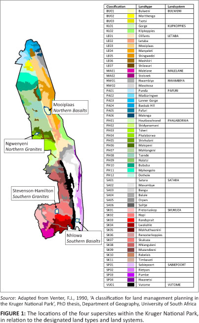
Venter (1990) characterised the KNP in terms of 11 land systems, defined by similarities in landforms and the hillslope sequences of soils and dominant woody and herbaceous vegetation at a scale of approximately 1:1 000 000. These land systems were further subdivided by Venter (1990) into 56 land types, mapped at a scale of approximately 1:250 000. The supersites occur within the four largest land systems (which account for 80% of the total park area), namely, Skukuza (Southern Granites, with relatively high rainfall), Phalaborwa (Northern Granites, with relatively low rainfall), Satara (Southern Basalts, with relatively high rainfall) and Letaba (Northern Basalts, with relatively low rainfall) (Figure 1). Venter's (1990) descriptions of the land types within which the supersites fall are summarised in the Online Appendix Tables 1 and 2, together with their hydrogeological characteristics (Online Appendix Table 3).
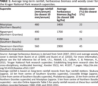
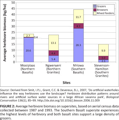
The characteristics of the supersites, including long-term average rainfall, herbaceous biomass and woody cover are described in Table 1 (also see Online Appendix Table 4 for annual rainfall history since 1941). A summary of the long-term fire history is provided in Table 2 and historic levels of herbivory in Figure 2 (also see Online Appendix Table 5 for density of specific herbivore species). Figure 3 outlines the average yearly phenological response of the supersites, based on the normalised difference vegetation index time series data, derived using Moderate Resolution Imaging
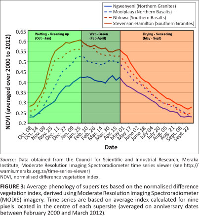
Spectroradiometer (MODIS) imagery collected between 2000 and 2012. Aerial and ground photographs of the sites are included in the Online Appendix Figures 1- 8 (see also Online Appendix Table 6 for details of historical aerial photography taken of the supersites between 1940 and 2001). The broader park-wide context within which the supersites occur appear as maps in the Online Appendix Figures 9-18 (e.g. depicting supersites in relation to camps and tourist roads, average herbaceous biomass, woody cover, fire return period, dry-season herbivore distribution and elephant distribution). The Online Appendix Figures 19-22 provide the locations (and site identification numbers) for sites on or within 5 km of the supersites for the following datasets, (1) soil and vegetation (herbaceous and woody) data collected by Venter (1990) and (2) vegetation condition assessment surveys carried out by the KNP rangers since 1989.
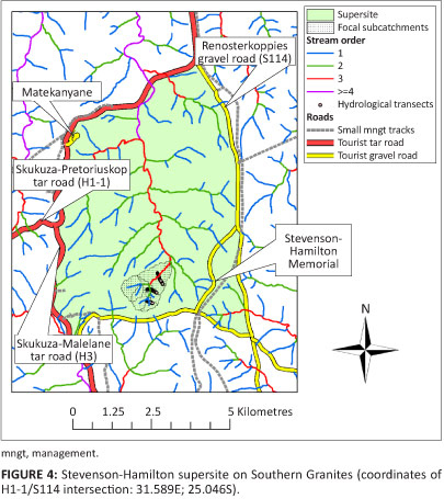
Southern Granites: Stevenson-Hamilton supersite
The Southern Granite supersite sits within the Renosterkoppies land type, which is a transitional zone between the land types associated with the perennial Sabie and Crocodile River catchments (Figure 4). The landscape is finely dissected, with a high stream density. The woody vegetation of the sandy crests is dominated by Combretum apiculatum and Combretum zeyheri. There is often a distinct seepline between the crest and the midslope, where Terminalia sericea is conspicuous. Fine leaved woody species such as Acacia nilotica dominate the more clayey midslopes and footslopes. Duplex, sodic soils are often found on the footslopes, characterised by the presence of Euclea divinorium. Concave stream channels generally have gravel beds.
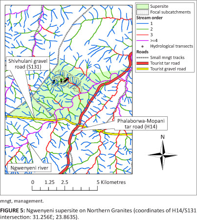
Northern Granites: Ngwenyeni supersite
The Northern Granite supersite falls within the Malopeni land type, part of the Phalaborwa land system (Figure 5). It is an intensely migmatised zone between the gneiss to the south and greenstone to the north. It is characterised by many small headwater tributaries of the Letaba River. Combretum apiculatum dominates on the shallow soils of the crests, whilst Colophospermum mopane is associated with the midslopes. Footslopes are dominated by C. mopane and some Acacia nigrescens.
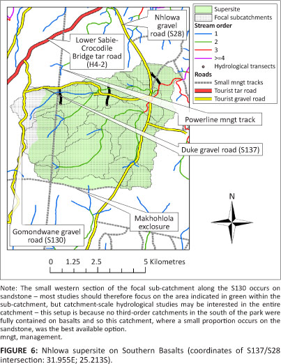
Southern Basalts: Nhlowa supersite
The Southern Basalt supersite occurs within the Satara land type, which is characterised by shallow to moderately deep red olivine-poor clays (Figure 6). These nutrient-rich soils support a high density of herbivores, with dense grass cover providing a reliable source of grazing. It is very flat with open tree savannah dominated by Sclerocarya birrea and A. nigrescens. Stream density is low, with wide grassy valley bottoms in headwater areas.
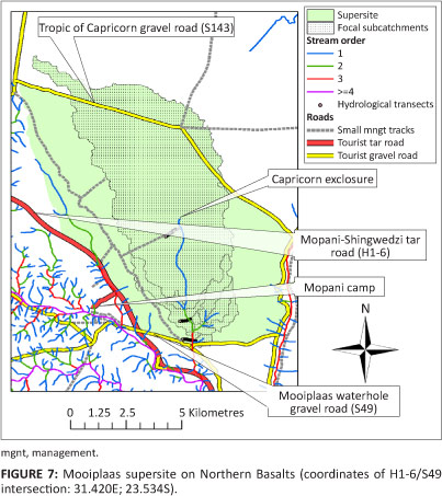
Northern Basalts: Mooiplaas supersite
The Northern Basalt supersite occurs within the Mooiplaas land type and is characterised by dark olivine-rich soils (Figure 7). It is very flat, with a very low stream density, shallow grassy vleis and large alluvial deposits along the major rivers. It is dominated by moderate to dense stands of C. mopane. Dichrostachys cinerea is a prominent shrub.
Discussion
Supersite datasets
Presently, a concerted effort is directed at collecting baseline datasets characterising the supersites. The existing datasets to date are summarised in Table 3.
Supersite data availability
The datasets described in Table 3 are available (or will become available shortly as they are finalised) from the SANParks data repository (http://www.dataknp.sanparks.org). It is expected that researchers using these datasets will also contribute additional data to the wider research community as they collect or derive new datasets for these sites. New data will be added to the SANParks data repository as they become available. In cases where the researchers want to publish the data before making it publicly available, a lead-time of up to 3 years will be granted. During this period, only an abstract of the data and the contact details of the relevant researcher will be visible on the repository; however, the data will be made available once the data owner provides permission, or at the latest after 3 years from the date of collection, as normally specified by SANParks.
Titles of all the supersite datasets will appear when searching the data repository using the term 'supersite' (with additional keywords focusing the search to be more specific). Once the list of dataset titles appears during a search, the required data and metadata can be downloaded directly. Researchers downloading supersite data from the data repository will be required to acknowledge the data collectors and/ or reference the publication associated with the specific dataset, as indicated in the metadata of each dataset. In a few exceptional cases where the data may be sensitive and/or where other restrictions (e.g. copyright) may apply, the users will only see the abstract and contact details of the person from which to request the data. All the data will be provided on an 'as is' basis and SANParks and the data collectors will not be responsible for any data errors (however, feedback on any data errors is encouraged).
Conclusion
The aim of the recent establishment of four research supersites in the KNP and the provision of spatially explicit baseline datasets for these locations is to stimulate a geographic focus for research and monitoring studies which currently happen on sites that are selected in an uncoordinated and haphazard manner. The supersites cover the two main abiotic variables that drive the large-scale variation in the park, namely, the rainfall gradient and the geological contrast, and contain entire lower order catchments. It is believed that these sites will result in a long-term, data-rich environment, which will provide the opportunity for better integration of datasets and disciplines. It is anticipated that this will lead to a deeper understanding of pattern and process on various spatio-temporal scales. The wealth of freely available spatially explicit datasets presently available or in process of finalisation will act as catalysts to attract further research projects to these sites and to stimulate the collection of additional datasets and knowledge generation.
Acknowledgments
We want to acknowledge all managers and scientists involved in the discussions and workshops during which the supersites were discussed and finalised. Special thanks also to Gabriela Bucini who co-organised a remote-sensing woody cover mapping workshop together with the primary author in 2009, which was useful in developing the supersite concept.
Competing interests
The authors declare that they have no financial or personal relationships which may have inappropriately influenced them in writing this article.
Authors' contributions
I.P.J.S. (SANParks) was the project leader and, together with E.S.R. (University of KwaZulu-Natal) and C.C. (University of the Witwatersrand), was closely involved in the supersite conceptualisation and delineation. I.P.J.S. prepared the manuscript with contributions from E.S.R. and C.C, whilst I.P.J.S. and C.C. created all the maps. R.P. (SANParks) coordinated many of the baseline studies presently occurring on the supersites and also contributed towards the manuscript.
References
Asner, G.P., Levick, S.R., Kennedy-Bowdoin, T., Knapp, D.E., Emerson, R., Jacobson, J. et al., 2009, 'Large-scale impacts of herbivores on the structural diversity of African savannas', Proceedings of the National Academy of Sciences of the United States of America 106(12), 4947-4952. http://dx.doi.org/10.1073/pnas.0810637106, PMid:19258457 PMCid:2650504 [ Links ]
Asner, G.P. & Levick, S.R., 2012, 'Landscape-scale effects of herbivores on treefall in African savanna', Ecology Letters 15(11), 1211-1217. [ Links ]
Biggs, R., Biggs, H.C., Dunne, T.T., Govender, N. & Potgieter, A.L.F., 2003, 'Experimental burn plot trial in the Kruger National Park: History, experimental design and suggestions for data analysis', Koedoe 46(1), 1-15. [ Links ]
Bucini, G., Saatchi, S., Hannan, N.P., Boone, R.B. & Smit, I.P.J., 2009, 'Woody cover and heterogeneity in the savannas of the Kruger National Park, South Africa', in Proceedings from the 2009 IEEE International Geoscience and Remote Sensing Symposium IV, Cape Town, South Africa, July 12-17, 2009, pp. 334-337. [ Links ]
Bucini, G., Hanan, N.P., Boone, R.B., Smit, I.P.J., Saatchi, S., Lefsky, M.A. et al., 2010, 'Woody fractional cover in Kruger National Park, South Africa: Remote-sensing-based maps and ecological insights', in M.J. Hill & N.P. Hanan (eds.), Ecosystem function in savannas: Measurement and modeling at landscape to global scales, pp. 219-237, CRC/Taylor and Francis, Boca Raton. [ Links ]
Caylor, K.K., D'odorico, P. & Rodriguez-Iturbe, I., 2006, 'On the ecohydrology of structurally heterogeneous semiarid landscapes', Water Resources Research 42(7), W07424. http://dx.doi.org/10.1029/2005WR004683 [ Links ]
Cullum, C. & Rogers, K.H., 2011, A framework for the classification of drainage networks in savanna landscapes, WRC report TT498/11, Water Research Commission, Pretoria. [ Links ]
Cullum, C. & Rogers, K.H., 2012, Using landscape classification within complex, heterogeneous systems, presented at the 10th Savanna Science Networking Meeting, Skukuza, 05-09 March, viewed 19 July 2012, from http://www.sanparks.org/assets/docs/parks_kruger/conservation/scientific/noticeboard/science_ network_meeting_2012/5-15-cullum.pdf [ Links ]
Du Toit, W.H., 1998, Geohidrologie van die Nasionale Krugerwildtuin gebaseer op die evaluering van bestaande boorgatinligting [Geohydrology of the Kruger National Park based on the evaluation of existing borehole information], vol. 1, Directorate Geohydrology internal report GH 3798, Department of Water Affairs and Forestry, Pretoria. [ Links ]
Jacobs, S.M. & Naiman, R.J., 2008, 'Large African herbivores decrease herbaceous plant biomass while increasing plant species richness in a semi-arid savanna toposequence', Journal of Arid Environments 72(6), 891-903. http://dx.doi. org/10.1016/j.jaridenv.2007.11.015 [ Links ]
Jenerette, G.D., Barron-Gafford, G.A., Guswa, A.J., McDonnell, J.J. & Villegas, J.C., 2012, 'Organization of complexity in water limited ecohydrology', Ecohydrology 5, 184-199. [ Links ]
Jonsson, M., Bell, D., Hjalten, J., Rooke, T. & Scogings, P.F., 2010, 'Do mammalian herbivores influence invertebrate communities via changes in the vegetation? Results from a preliminary survey in Kruger National Park, South Africa', African Journal of Range and Forage Science 27(1), 39-44. [ Links ]
Knapp, K.A., Smith, M.D., Hobbie, S.E., Collins, S.L., Fahey, T.J., Hansen, G.J.A. et al., 2012, 'Past, present, and future roles of long-term experiments in the LTER network', Bioscience 62(4), 377-389. [ Links ]
Levick, S.R., Asner, G.P., Kennedy-Bowdoin, T. & Knapp, D.E., 2009, 'The relative influence of fire and herbivory on savanna three-dimensional vegetation structure', Biological Conservation 142(8), 1693-1700. http://dx.doi.org/10.1016/j.biocon.2009.03.004 [ Links ]
Milne, G., 1935, 'Some suggested units for classification and mapping, particularly for East African soils', Soil Research 4, 183-198. [ Links ]
Noy-Meir, I., 1973, 'Desert ecosystems: Environment and producers', Annual Review of Ecology and Systematics 4, 25-51. [ Links ]
Schulze, R.E., Maharaj, M., Lynch, S.D., Howe, B.J. & Melville-Thomas, B., 1997, South African atlas of agrohydrology and -climatology, WRC report TT82/96, Water Research Commission, Pretoria. [ Links ]
Smit, I.P.J., 2007, 'Artificial surface-water provision in a semi-arid savanna. A spatio-temporal analysis of herbivore distribution patterns in relation to artificial waterholes under different habitat, rainfall and management scenarios in the Kruger National Park, South Africa', PhD thesis, Department of Geography, University of Cambridge. [ Links ]
Smit, I.P.J., 2011, 'Resources driving landscape-scale distribution patterns of grazers in an African savanna', Ecography 34(1), 67-74. http://dx.doi.org/10.1111/j.1600-0587.2010.06029.x [ Links ]
Smit, I.P.J. & Ferreira, S.M., 2010, 'Management intervention affects river-bound spatial dynamics of elephants', Biological Conservation 143(9), 2172-2181. http:// dx.doi.org/10.1016/j.biocon.2010.06.001 [ Links ]
Smit, I.P.J., Grant, C.C. & Devereux, B.J., 2007, 'Do artificial waterholes influence the way herbivores use the landscape? Herbivore distribution patterns around rivers and artificial surface water sources in a large African savanna park', Biological Conservation 136(1), 85-99. http://dx.doi.org/10.1016Zj.biocon.2006.11.009 [ Links ]
Smit, I.P.J., Smit, C.F., Govender, N., Van der Linde, M. & MacFadyen, S., 2013, 'Rainfall, geology and landscape position generate large-scale spatiotemporal fire pattern heterogeneity in an African savanna', Ecography 36(4), 447-459. http://dx.doi.org/10.1111/j.1600-0587.2012.07555.x [ Links ]
Van der Schijff, H.P., 1958, 'Inleidende verslag oor veldbrandnavorsing in die Nasionale Krugerwildtuin [Introductory report on veld burning research in the Kruger National Park]', Koedoe 1(1), 60-93. [ Links ]
Van Jaarsveld, A.S., Pauw, J.C., Mundree, S., Mecenero, S., Coetzee, B.W.T. & Alard, G.F., 2007, 'South African environmental observation network: Vision, design and status', South African Journal of Science 103, 289-294. [ Links ]
Van Wilgen, B.W., Govender, N. & Biggs, H.C., 2007, 'The contribution of fire research to fire management: A critical review of a long-term experiment in the Kruger National Park, South Africa', International Journal of Wildland Fire 16(5), 519-530. http://dx.doi.org/10.1071/WF06115 [ Links ]
Venter, F.J., 1990, 'A classification for land management planning in the Kruger National Park', PhD thesis, Department of Geography, University of South Africa. [ Links ]
Venter, F.J., Scholes, R.J. & Eckhardt, H.C., 2003, 'The abiotic template and its associated vegetation pattern', in J.T. du Toit, K.H. Rogers & H.C. Biggs (eds.), The Kruger experience: Ecology and management of savanna heterogeneity, pp. 83129, Island Press, Washington, DC. [ Links ]
 Correspondence:
Izak Smit
Private Bag X402, Skukuza 1350, South Africa
izak.smit@sanparks.org
Received: 24 Aug. 2012
Accepted: 14 Jan. 2013
Published: 12 Apr. 2013

