


Serviços Personalizados
Artigo
 Inglês (pdf)
 Artigo em XML
 Referências do artigo
Indicadores

Links relacionados
-
 Citado por Google
 -
 Similares em Google
Compartilhar

 Permalink
Koedoe
versão On-line ISSN 2071-0771
versão impressa ISSN 0075-6458
Koedoe vol.52 no.1 Pretoria Jan. 2010
ORIGINAL RESEARCH
The vegetation and floristics of the Letaba exclosures, Kruger National Park, South Africa
Frances SiebertI; Holger C. EckhardtII; Stefan J. SiebertI
ISchool of Environmental Sciences and Development, North-West University, South Africa
IIScientific Services, South African National Parks, South Africa
ABSTRACT
The construction of exclosures along two of the most important rivers in the Kruger National Park was done to investigate how patterns of spatial and temporal heterogeneity of the riparian zone is affected by fire, flood and herbivory. To assist this research programme, vegetation surveys were conducted within exclosures along the Letaba River to classify and map the vegetation of the area. The history and experimental design of the Letaba exclosures are similar to that of the Nkhuhlu exclosures along the Sabie River, which is directly related to questions surrounding elephant management. The main difference between the Nkhuhlu and Letaba exclosures is local heterogeneity, since the latter lies within the Mopaneveld, which is floristically and physiognomically much more homogenous than the vegetation of the southern Kruger National Park. Nevertheless, four plant communities, eight sub-communities and six variants were recognised and mapped for the Letaba exclosures. The vegetation description was done in relation to prevailing soil forms, differences in species richness, diversity and community structure, and therefore should serve as a basis for further detailed and broad-based botanical studies. Vegetation mapping was done to sub-community level and, where possible, to variant level. As expected in Mopaneveld vegetation, the plant communities could broadly be related to soil types, although smaller-scale variations correspond to soil moisture availability because the Mopaneveld is considered 'event-driven', especially in the herbaceous layer.
Conservation implications: Floristic surveying and vegetation mapping of a long-term monitoring site, such as the Letaba exclosures, is seen as a baseline inventory to assist natural resource management. Linking mapping units to biodiversity strengthens the understanding needed to maintain biodiversity in all its natural facets and fluxes.
Keywords: biodiversity; Letaba River; Mopaneveld; riparian vegetation; savanna; vegetation mapping
INTRODUCTION
Situated on the banks of the Letaba River, in the northern half of the Kruger National Park (KNP), the Letaba exclosures were constructed in 2002. For the same reason and purpose as the Nkhuhlu exclosures, namely to monitor spatial and temporal heterogeneity along the riparian zone and attempt to determine how these are affected by fire and herbivory (Siebert & Eckhardt 2008). Also, the history and experimental design of the Letaba exclosures are similar to those of the Nkhuhlu exclosures (O'Keefe & Alard 2002), which is directly related to questions surrounding elephant management. The different treatment blocks at the Letaba exclosures vary in size, with 42 ha, 51 ha and 36 ha respectively, for the full exclosure, partial exclosure and unfenced area. The main difference between the Nkhuhlu and Letaba exclosures is local heterogeneity, because the latter lies within the Mopane Bioregion (Mucina & Rutherford 2006), which is floristically and physiognomically much more homogenous than the southern savannas of the KNP. Animal concentrations are consequently relatively low, exacerbated by the fact that, approximately a decade ago, the Letaba River changed from a perennial river to a seasonal river (O'Keeffe & Rogers 2003). The lower mean annual rainfall (approximately 400 mm), compared to the annual 560 mm at Nkhuhlu, drives a different fire regime and mammal concentrations. These not only translate into less obvious differences between the different treatments at the Letaba exclosures, but also in a lower rate of changes overall.
In 2000, a flood caused the Letaba River to rise above its macro-channel banks, but did not cause as dramatica change to the riparian vegetation as was recorded for the Sabie River (Parsons, McLoughlin, Kotschy, Rogers & Rountree 2005). Nevertheless, the changes brought about by this large, infrequent disturbance provide an ideal opportunity and context to study and understand the dynamics of ecosystems subjected to different management options. Baseline vegetation surveys were conducted initially and repeated five years later, in 2007, to assess differences between the six treatments in terms of plant species composition and structure for both the woody and herbaceous component (O'Keefe & Alard 2002). The results from this survey will be published at a later stage. A detailed soil inventory was conducted by Paterson and Steenekamp (2003), the results of which were used to help delineate plant communities. Owing to their remoteness and other logistical reasons, the Letaba exclosures have not received the same degree of attention from researchers as the Nkhuhlu exclosures. This has led to missed opportunities with regard to the flood legacy. The detailed vegetation classification and floristic description presented here will hopefully attract more interest from scientists, leading to research projects addressing key environmental questions.
STUDY AREA
The Letaba exclosures are situated approximately 5 km upstream of the Mingerhout Dam, along the northern bank of the Letaba River in the Kruger National Park. The exclosures consist of six treatments:
• a fully fenced area (42 ha) excluding all herbivores, divided into, (1) a burn block and (2) a no-burn block
• a partially fenced area (51 ha) excluding only elephant and giraffe, also divided into a burn (3) and no-burn (4) block
• (5) an unfenced area protected from fire only (36 ha)
• (6) a 400 m wide buffer area that is subjected to fire and herbivory.
The total experimental area is 129 ha, excluding the area along the river, which forms a narrow strip inside the river bed (the socalled 'sacrificial zone') and the buffer zone adjacent to the three inland sides of the project area.
This summer rainfall region receives approximately 400 mm per annum, as measured at Letaba rest camp, while the mean daily temperature is 23.3ºC, ranging from 7.8ºC in winter, to a maximum of 34.1ºC in summer (Weather Bureau 1986). The most representative underlying geology is granite and Makhutswi gneiss, which contains Swaziland rock formations such as amphibolite and migmatite (Visser, Coertze & Walraven 1989).
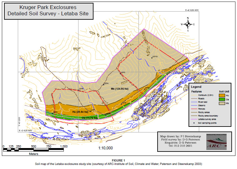
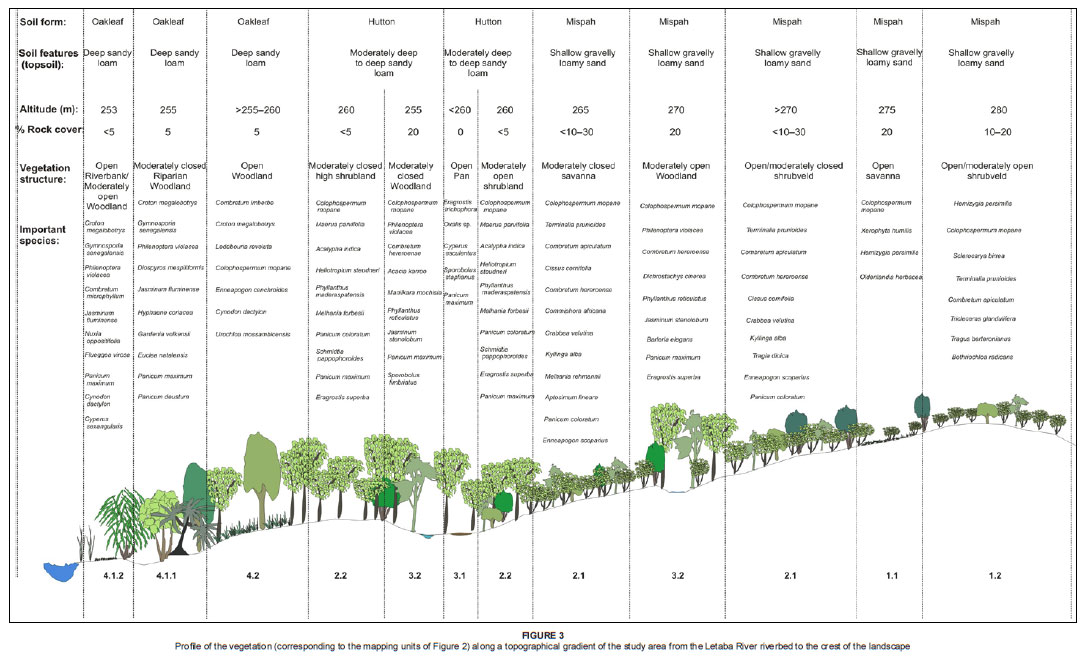
According to Paterson and Steenekamp (2003), the Letaba exclosures have a relatively simple soil distribution, with Mispah being the most representative soil form along the midslopes and crests. Hutton soils form a strip of deeper apedal soils along the footslopes, whereas alluvial soils of the Oakleaf soil form characterises the banks of the Letaba River (Figure 1). The topography of the area is characterised by a gently undulating landscape without any prominent koppies.
The vegetation of the Letaba exclosures is classified as 'Letaba River Rugged Veld' (Landscape 10, Gertenbach 1983). The vegetation of the drier upper savanna areas contains elements of Landscape 22, the 'Combretum spp. / Colophospermum mopane Rugged Veld' (Gertenbach 1983) and is floristically linked to the 'Colophospermum mopane - Combretum apiculatum - Digitaria eriantha Open Tree Savanna', described by Van Rooyen, Theron and Grobbelaar (1981). The riparian zone of the Letaba site forms part of Subtropical Alluvial Vegetation (unit AZa7 of the Inland azonal vegetation), whereas the zonal savanna area forms part of the Lowveld rugged mopaneveld (SVmp6) in the Mopane Bioregion (Mucina & Rutherford 2006). On a larger scale, the vegetation of the Letaba exclosures forms part of the Combretum apiculatum-Colophospermum mopane major plant community on granite and gneiss in the Cissus cornifolia - Colophospermum mopane vegetation type (Siebert, Bredenkamp & Siebert 2003). Mopaneveld on granitic substrates is typically in association with Combretum spp., where the latter dominates the sandy crests and Colophospermum mopane the more clayey substrates of the bottomlands (Du Plessis 2001). Of the four major plant communities identified and described by Bredenkamp and Van Rooyen (1993), three are represented at the Letaba site, of which some are typically found in the study area.
Species that characterise the riparian zone include woody species such as Croton megalobotrys, Nuxia oppositifolia, Gymnosporia senegalensis, Philenoptera violacea, Diospyros mespiliformis, Combretum microphyllum and Trichilia emetica. Inland, the vegetation is typically dominated by Colophospermum mopane, with variation in species associations that co-exist in the woody layer. Woody species, other than Colophospermum mopane, that characterise the savanna zone of the Letaba site, include Combretum apiculatum, Terminalia prunioides, Dichrostachys cinerea, Maerua parvifolia, Cissus cornifolia, Commiphora mollis, C. africana, Grewia bicolor, Combretum imberbe, Acacia nigrescens, Acacia exuvialis and Rhigozum zambeziacum. Grasses, such as Panicum coloratum, Schmidtia pappophoroides, Melinis repens, Bothriochloa radicans,and forbs such as Crabbea velutina, Ocimum americanum, Phyllanthus maderaspatensis, Pavonia burchellii, Hibiscus micranthus and Jasminum stenolobum, characterise the field layer.
METHOD
Classification and mapping
Vegetation sampling, classification and mapping was based on the approach followed in the study of the Nkhuhlu exclosures (Siebert & Eckhardt 2008). A total of 83 plots were identified through randomised stratification, of which 72 plots were sampled in detail using the Braun-Blanquet scale (Mueller-Dombois & Ellenberg 1974). Total floristics were obtained for each 20 m × 20 m plot to allow for comparison of species diversity and richness between the different plant communities. Plant species names conform to those of Germishuizen and Meyer (2003).
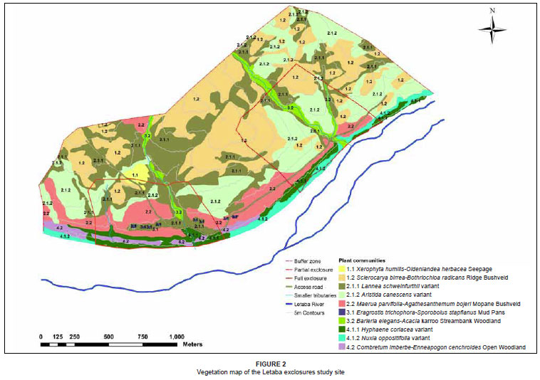
Braun-Blanquet procedures were used to refine the classification results of the TWINSPAN (Hill 1979) application using the MEGATAB computer program (Hennekens 1996). The results are presented in a phytosociological table (see online Appendix). Results from the classification and subsequent refinement were used to construct a 1:5000 vegetation map for the Letaba exclosures (Figure 2). Mapping was done to the subcommunity level in ArcMap™ of the ESRI ArcGIS 9.1®computer package. To improve the understanding of the map in terms of the topography, the distribution of the plant communities is presented in a profile drawing (Figure 3) that was constructed using Corel Draw Suite 9©.
Floristic analysis
Floristic data were analysed to allow floristic comparison across mapping units and were therefore presented on variant level where appropriate. The approach for floristic comparison followed the method used for the Nkhuhlu exclosures (Siebert & Eckhardt 2008), which entailed the use of Shanon-Wiener diversity indices to combine species richness and relative abundance among species (Barbour, Burk & Pitts 1987) for comparison across mapping units. The Braun-Blanquet scale was converted to percentage cover and the mean cover per species within the plant community was taken as its abundance value.
RESULTS
Classification and mapping
First order divisions, created by the hierarchical classification of the Letaba data set, separated riparian woodland from the dryland woodland communities, the latter of which are dominated by Co lophospermum mopane and differentiated according to elevation and drainage. These two vegetation types represent four main communities, which include eight subcommunities and six variants after refinement:
1. Hemizygia bracteosa - Acacia exuvialis crest savannah
1.1 Xerophyta humilis
- Oldenlandia herbacea seepage
1.2 Sclerocarya birrea - Bothriochloa radicans ridge bushveld
1.2.1 Senna italica variant
1.2.2 Typical variant
2. Schmidtia pappophoroides - Colophospermum mopane lowland savanna
2.1 Melhania rehmannii - Enneapogon scoparius mixed bushveld
2.1.1 Lannea schweinfurthii variant
2.1.2 Aristida canescens variant
2.2 Maerua parvifolia-Agathisanthemum bojeri mopane bushveld
3. Sporobolus fimbriatus - Grewia bicolor seasonally wet savanna
3.1 Eragrostis trichophora - Sporobolus stapfianus mud pans
3.2 Barleria elegans - Acacia karroo streambank woodland
4. Croton megalobotrys - Panicum deustum riverine woodland
4.1 Philenoptera violacea - Jasminum fluminense riverbank woodland
4.1.1 Hyphaene coriacea variant
4.1.2 Nuxia oppositifolia variant
4.2 Combretum imberbe - Enneapogon cenchroides open woodland. The identified plant assemblages are distributed throughout the Letaba exclosures study area and are well-presented in all treatment blocks at plant community level (Figure 2). Some communities have a limited distribution range due to smallscale disturbances and patchiness, for example the Xerophyta humilis - Oldenlandia herbacea seepage (1.1) and the Eragrostis trichophora - Sporobolus stapfianus mud pans (3.1).
Sub-communities are easily identifiable in the field; some can even be distinguished at variant level, for instance the Lannea schweinfurthii (2.1.1) and Aristida canescens (2.1.2) variants of the Melhania rehmannii - Enneapogon scoparius mixed bushveld, as well as the Hyphaene coriacea (4.1.1) and Nuxia oppositifolia (4.1.2) variants of the Philenoptera violacea - Jasminum fluminense riverbank woodland. Vegetation mapping was therefore done up to variant level where possible, although sub-communities form the most representative units of the vegetation map (Figure 2).
A schematic presentation of plant community distributions - from the Letaba River to the crest of the landscape (Figure 3) - illustrates changes in the vegetation along the riparian catena. The riverbed and lower riverbank is characterised by plant species of the Nuxia oppositifolia variant (4.1.2). On the slightly elevated riverbank, the Hyphaene coriacea variant (4.1.1) can easily be recognised by the presence of prominent trees, such as Hyphaene coriacea, Philenoptera violacea, Croton megalobotrys and Combretum hereroense. The Hyphaene coriacea variant is often interrupted by drier, open woodland, the Combretum imberbe - Enneapogon cenchroides open woodland (4.2), on the higher terraces of the Letaba River. Higher up into the savanna zone, the vegetation varies from a closed, almost homogenous mopane woodland (2.2), via a mixed bushveld (2.1) that is interrupted by narrow green 'belts' (2.1.1), to a crest bushveld (1), which includes the Sclerocarya birrea - Bothriochloa radicans ridge bushveld (1.2) and a unique, localised seepage (1.1) (Figure 3).
Floristic analysis
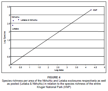
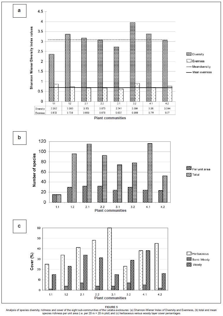
Compared to the Nkhuhlu exclosures, the plant richness per area of the Letaba exclosures is low (Figure 4), due to Colophospermum mopane dominating the tree and shrub layers (O'Connor 1992; Du Plessis 2001). The overall plant richness per area, of both the Nkhuhlu and Letaba exclosures, is above average for the Kruger National Park (Figure 4).
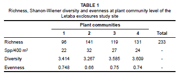
At community level, the Schmidtia pappophoroides - Colophospermum mopane lowland savanna (community 2) hosts the highest alpha diversity (species richness per unit area) at 32 species per plot and a total of 141 different plant species. However, the Shannon-Wiener Diversity Index, which combines both richness and equitability, revealed it has a low diversity and evenness (Table 1), attributable to the almost sole dominance of Colophospermum mopane (O'Connor 1992; Du Plessis 2001). The highest alpha diversity on sub-community level was recorded for the Philenoptera violacea - Jasminum fluminense riverbank woodland (4.1) and the Melhania rehmannii - Enneapogon scoparius mixed bushveld (2.1) (Figure 5). The highest floristic diversity on sub-community level was measured for the streambank woodland (3.2), with a value of 3.9 (Figure 5), which can be attributed to the variation in bordering savanna plant communities, from which individuals spread into this subcommunity with moist soils.
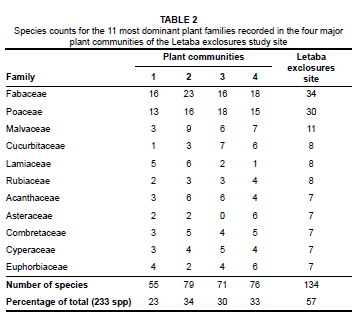
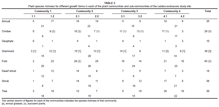
Floristically, the study area is dominated by taxa from the Fabaceae, Poaceae and Malvaceae (Table 2). The dominant growth forms in the study area are forbs, graminoids, trees and shrubs, although several climber species were recorded (Table 3). Succulents are less prominent, compared to the Nkhuhlu exclosures.
DISCUSSION
Description of plant communities
The Letaba exclosures experimental site lies in the geological and climatically uniform Landscape 10 of Gertenbach (1983), namely the 'Letaba River Rugged Veld'. No major climatic variation occurs that could have an effect on the local differentiation of plant communities. Small-scale heterogeneity of environmental factors could contribute to variations in plant assemblages. Detailed descriptions of the plant communities are therefore important to explain and provide support for the delineation of each mapping unit in a heterogeneous landscape.
1. Hemizygia bracteosa - Acacia exuvialis crest savanna
This community forms one of four plant communities within the study site and comprises approximately 30% of the total sampling area (including the buffer zone). It is spread out across the exclosure fence lines, with little difference between the three exclosure types in terms of plant composition. It extends over the crests of the savanna landscape inland of the Letaba River and is associated with shallow, greyish-brown, gravelly loamy sand to sandy loam topsoil directly overlying hard rock of the Mispah soil form (Paterson & Steenekamp 2003) (Figure 1).
The Hemizygia bracteosa - Acacia exuvialis crest savanna varies from open to moderately open shrubveld. The field layer is dominated by forbs, whereas shrubs constitute the dominant growth form in the woody layer. It is floristically characterised by species group 1 (see online Appendix), which includes Acacia exuvialis in the woody layer, and Hemizygia bracteosa and Tricliceras laceratum in the forb layer (species group 1). Dominant species include the trees Colophospermum mopane, Terminalia prunioides and Combretum apiculatum and the grass Panicum coloratum (species group 14). Species frequently present include the grasses Bothriochloa radicans, Tragus berteronianus (species group 3), Schmidtia pappophororoides (species group 5) and Enneapogon scoparius (species group 10), whereas Evolvulus alsinoides, Clerodendrum ternatum (species group 10), Lantana rugosa, Ceratotheca triloba and Pavonia burchellii (species group 14) are commonly found in the forb layer.
This community is floristically the poorest, with a total of 96 plant species recorded (Table 1), which contribute to only 41% of the species richness of the Letaba exclosures. Diversity and evenness scores are at a moderate level for the study area (Table 1). Taxa of the Fabaceae and Poaceae (Table 2) floristically dominate the crest savanna.
The crest savanna contains elements of the 'Combretum spp. / Colophospermum mopane landscape' (Landscape 22, Gertenbach 1983) in the field layer, but not typically in the woody layer, except for common trees such as Colophospermum mopane, Terminalia sericea, Acacia exuvialis, Combretum apiculatum and Acacia nigrescens. This savanna community is too distant to associate its plant assemblages with the riparian vegetation described by Bredenkamp and Van Rooyen (1993), although it does contain elements of the Colophospermum mopane - Terminalia prunioides Dry Riparian Woodland (community 1.1.2, Bredenkamp & Van Rooyen 1993).
Two sub-communities were identified for the Hemizygia bracteosa - Acacia exuvialis crest savanna:
1.1 Xerophyta humilis -Oldenlandia herbacea seepage: This subcommunity is not widely distributed in the Letaba exclosures site, nor in the adjacent Colophospermum mopane savanna surrounding the study area. It covers only a small patch (1% of the study area) on the crest of the landscape where underground water seeps through the surface, resulting in a seasonally wet area. Mispah is the dominant soil form, with a stony soil surface that is often underlain by rock plates where moisture accumulates. This somewhat unique plant community is found within the buffer zone of the full exclosure, extending into the full exclosure. It is an open savanna dominated by low Colophospermum mopane shrubs of approximately 3 m in height, which are interrupted by damp, open patches dominated by Xerophyta humilis. Woody cover percentage is the lowest in this sub-community. Cover in the herbaceous layer is approximately 25%.
The seepage, which is dominated by herbaceous species (Figure 5), is characterised by species group 2 (see online Appendix). Since this sub-community is not typically found in the study area it is undersampled, represented by only one relevé: sample plot 12. The most conspicuous woody species is Colophospermum mopane (species group 14) in its low shrub (± 3 m) form. Graminoids such as Melinis repens (species group 2), Schmidtia pappophoroides (species group 5) and Panicum coloratum (species group 14) occur, but with low percentage cover. Prominent forbs include, other than Xerophyta humilis and Oldenlandia herbacea (species group 2), Kohautia virgata (species group 9), Evolvulus alsinoides (species group 10), Tephrosia purpurea and Ceratotheca triloba (species group 14).
This sub-community has a species richness value of 15, which is also the mean species number per sampling plot (Figure 5).
1.2 Sclerocarya birrea - Bothriochloa radicans ridge bushveld: This sub-community is widespread in the savanna uplands of the Letaba exclosures site, especially along the crests of the landscape which predominantly occurs within the 400 m bufferzone (Figure 2). Soils underlying this sub-community are mainly from the Mispah soil form. The vegetation is structurally characterised by an open to moderately open shrubveld. The herbaceous layer has a cover of 34% and the woody layer covers approximately 23% of the area (Figure 5).
This ridge bushveld is characterised by species group 3 (see online Appendix) and include Sclerocarya birrea in the woody layer and Tragus berteronianus and Bothriochloa radicans in the grass layer. The woody layer is dominated by Colophospermum mopane (species group 14). Prominent woody species comprise Rhigozum zambesiacum (species group 10), Terminalia prunioides and Combretum apiculatum (species group 14). Forbs include Indigofera nebrowniana (species group 7), Evolvulus alsinoides, Dicoma tomentosa, Talinum caffrum, Clerodendrum ternatum (species group 10), Ceratotheca triloba, Hibiscus micranthus, Lantana rugosa, Melhania acuminata, Ocimum americanum, Pavonia burchellii, Phyllanthus incurvus and Phyllanthus maderaspatensis (species group 14).
Species richness is 96, whereas mean species number per plot is 30 (Figure 5). The diversity for this sub-community is above average, common for plant communities found on ridges (Siebert et al. 2003). Evenness is average for the Letaba site (Figure 5).
Two variants were identified but do not represent different mapping units. These variants were:
1.2.1 Senna italica variant: This variant is structurally classified as moderately open to open shrubveld on slightly elevated crests on shallow soils of the Mispah soil form. It is less stoney than the Typical variant and occurs in the open control area, the partial exclosure and in the buffer zone outside the northeastern border of the partial exclosure. Characteristic species of this variant are listed in species group 4 and comprise Senna italica, Heliotropium ovalifolium, Boerhavia diffusa, Corbichonia decumbens and Pterodiscus speciosus, all of which are in the herbaceous layer. Hemizygia bracteosa (species group 1) is less abundant here than the typical variant. Dominant species include Colophospermum mopane, Terminalia prunioides and Panicum coloratum (species group 14), whereas Combretum apiculatum (species group 14), Bothriochloa radicans (species group 3) and Enneapogon scoparius (species group 14) are locally prominent.
1.2.2 Typical variant: This variant occurs as interrupted patches of moderately open shrubveld and is in general associated with crests on shallow soils covered by granitic pebbles, associated with the Mispah soil form. It covers most of the upland savanna vegetation towards the north-eastern border of the partial exclosure, as well as outside the exclosure in the bufferzone. There are no species that typically characterise this variant, although the absence of species group 4 may serve as an indicator of this typical variant. The dominance of Hemizygia bracteosa (species group 1) is characteristic. Important species in the woody layer, other than Colophospermum mopane, include Acacia exuvialis (species group 1), Sclerocarya birrea (species group 3), Rhigozum zambesiacum (species group 10), Terminalia prunioides, Combretum apiculatum, Acacia nigrescens and Dichrostachys cinerea (species group 14). Other species present in the herbaceous layer are grasses such as Bothriochloa radicans (species group 3), Schmidtia pappophoroides (species group 5), Enneapogon scoparius (species group 10), Panicum maximum (species group 21) and forbs such as Indigofera nebrowniana (species group 7), Ocimum americanum, Ceratotheca triloba (species group 14) and Waltheria indica (species group 21).
2. Schmidtia pappophoroides - Colophospermum mopane lowland savanna
This lowland savanna typically belongs to the Lowveld Rugged Mopaneveld (SVmp6, Mucina & Rutherford 2006) and covers the largest portion of the Letaba exclosures site. It is a typical Mopaneveld plant community that is widespread in the KNP and adjacent savanna areas. Its nearest counterpart in plant communities, as have been described previously, is the Colophospermum mopane - Combretutum apiculatum -Digitaria eriantha Open Tree Savanna (Van Rooyen et al. 1981), which occurs further north of the Letaba exclosures site, in the Punda Maria region. This typical mopaneveld community occurs on granitic soils of the Mispah soil form (Siebert et al. 2003).
Structurally, this savanna type varies from an open shrubveld to closed savanna woodland. The dominant growth form in the field layer is forbs, whereas shrubs dominate the woody layer. This community is floristically characterised by species group 5. The woody layer is dominated by Colophospermum mopane and Terminalia prunioides (species group 14). The grass layer is dominated by Panicum coloratum (species group 14) and Schmidtia pappophoroides (species group 5). The grasses Enneapogon scoparius (species group 10), Eragrostis superba and Panicum maximum (species group 21) are prominent. Forbs such as Crabbea velutina, Hibiscus praeteritus, Ruellia cordata (species group 5), Evolvulus alsinoides, Limeum fenestratum, Talinum caffrum, Clerodendrum ternatum (species group 10), Ocimum americanum, Phyllanthus maderaspatensis, Lantana rugosa, Hibiscus micranthus (species group 14), Waltheria indica, Kyllinga alba and Melhania forbesii (species group 21) are present in this community.
Total species count for this community is 141, which is the highest for the Letaba study area (Table 1). This community scored the lowest on the diversity index and its low evenness (Table 1) can be attributed to the almost complete dominance by Colophospermum mopane in both the tree and the shrub layer. Despite its low diversity, this community contains the highest richness of forbs, graminoids and annuals for the study area (Table 3). Half of its species are members of the Fabaceae and Poaceae, although the highest number of species in the Malvaceae has been recorded in this community (Table 2).
The lowland savanna consists of two sub-communities that are easily recognisable in the field. Even the variants are distinguishable and are represented by different mapping units (Figure 2).
2.1 Melhania rehmannii -Enneapogon scoparius mixed bushveld: Mixed bushveld of the Letaba exclosures site is typically associated with midslopes and footslopes, extending over all exclosure fence lines into the buffer zone. It covers the largest area of the study site. The dominant soil form underlying this sub-community is Mispah (Paterson & Steenekamp 2003). Structurally, it varies from open shrubveld to closed high shrubveld, and is dominated alternately by Colophospermum mopane and Combretum apiculatum. As in most other plant communities of the Letaba exclosures site, the highest vegetation cover is in the herbaceous layer (Figure 5; Table 3).
Species from species group 6 (see online Appendix) characterise the floristic composition of this sub-community and include Melhania rehmannii, Aptosimum lineare, Asparagus setaceus, Abutilon angulatum, Becium filamentosum, Dumasia villosa and Coccinia adoensis, all of which are representative of the forb layer. Conspicuous woody species include Cissus cornifolia (species group 5), Colophospermum mopane, Combretum apiculatum, Dichrostachys cinerea (species group 14), Cassia abbreviata (species group 20) and Combretum hereroense (species group 21). Prominent forbs, other than the character species, are Crabbea velutina, Ruellia cordata (species group 5), Evolvulus alsinoides, Dicoma tomentosa, Clerodendrum ternatum (species group 10), Ocimum americanum, Lantana rugosa, Melhania acuminata, Phyllanthus incurvus, Pavonia burchellii, Hibiscus micranthus, Tragia dioica (specis group 14), Kyllinga alba and Waltheria indica (species group 21). In the grass layer, Pogonarthria squorrosa, Schmidtia pappophoroides (species group 9), Digitaria eriantha (species group 16), Panicum maximum and Tragus beteronianus (species group 28) are most common.
This sub-community contains the highest number of graminoids, forbs and dwarf shrubs (Table 3), which explains its high species richness (115 taxa, Figure 5), the second highest for the Letaba exclosures site. Mean species per sampling plot is 32. Diversity is average for the Letaba study area, whereas the evenness is below average as a result of the dominance of Colophospermum mopane (Figure 5).
Two variants were identified that are easily be differentiated in the field, due to the difference in vegetation structure. Although species composition does not vary significantly between these two variants, they alternate along the midslopes and footslopes of the landscape.
2.1.1 Lannea schweinfurthii variant: This mosaic of moderately closed to closed savanna occurs throughout the study area on slightly deeper soils of the Mispah soil form. The Lannea schweinfurthii variant is very apparent from an aerial view and appears as green 'tongues' dissecting the savanna Mopaneveld (Figure 2). It is conspicuously present in the study area and structurally it becomes more dense towards the Letaba River, in particular the area surrounding the mud pans (community 3.1) (Figure 2).
Species group 7 (see online Appendix) characterises this variant and include tree species such as Lannea schweinfurthii and Commiphora africana. The herbaceous layer is characterised by the climbers Vigna luteola and the forbs Indigofera nebrowniana, I. cryptantha and Ocimum gratissimum. The vegetation is dominated by the tree Colophospermum mopane (species group 14) and the grasses Enneapogon scoparius (species group 10) and Schmidtia pappophoroides (species group 5). Prominent species include: the trees Terminalia prunioides and Combretum apiculatum, the grasses, Panicum coloratum, (species group 14) and Panicum maximum (species group 21) and the forbs, Kyllinga alba and Waltheria indica (species group 21). Other woody species present, include Maerua parvifolia (species group 9), Philenoptera violacea (species group 16), Cassia abbreviata (species group 20) and Combretum hereroense (species group 21). Forb species such as Crabbea velutina (species group 5), Evolvulus alsinoides, Commelina africana, Talinum caffrum and Clerodendrum ternatum (species group 10) are also present.
2.1.2 Aristida canescens variant: The Aristida canescens variant makes up the open to moderately open part of this mixed bushveld, overlying shallow soils of the Mispah soil forms (Paterson & Steenekamp 2003). It is found throughout the study area, stretching over all exclosure types and along the buffer zone in the north and the west (Figure 2).
Species group 8 (see online Appendix) floristically characterises the variant, which includes no woody species, but only the grass Aristida canescens and the forbs Rhynchosia totta, Cleome monophylla and Mariscus sumatrensis. Trees such as Colophospermum mopane, Terminalia prunioides and Combretum apiculatum (species group 14) dominate the woody layer, with prominent species in the forb layer being Crabbea velutina (species group 5), Ocimum americanum, Phyllanthus maderaspatensis, Ceratotheca triloba and Phyllanthus incurvus (species group 21). Schmidtia pappophoroides (species group 5), Enneapogon scoparius (species group 10), Panicum coloratum (species group 14), Eragrostis superba, Urochloa mosambicensis and Panicum maximum (species group 21) are the most conspicuous grasses.
2.2 Maerua parvifolia -Agathisanthemum bojeri mopane bushveld: This mopane bushveld occurs along the bottomlands of the landscape, on the elevated terraces above the riparian zone of the Letaba River. It forms a continuous band of moderately closed, tall Colophospermum mopane shrubland, except in the full exclosure, where it extends higher up into the midslopes where the structure is significantly more open shrubveld. Structurally, it resembles the Lannea schweinfurthii variant (2.1.1), although the mopane bushveld is weaker in terms of species richness. This sub-community is associated with moderately deep to deep, brown to reddish-brown, unstructured sandy loam topsoil of the Hutton soil form (Paterson & Steenekamp 2003).
This moderately closed shrubland is characterised by species group 9 (see online Appendix), of which the shrub Maerua parvifolia and the forbs Acalypha indica and Heliotropium steudneri are the most prevalent. It has floristic affinities to the Lannea schweinfurthii variant, of which Maerua parvifolia, Agathisanthemum bojeri and Eragrostis rigidior provide evidence (species groups 8 and 9). Colophospermum mopane (species group 14) dominates the tree and shrub layer, although other species, such as Maerua parvifolia (species group 9), Rhigozum zambesiacum (species group 10), Terminalia prunioides and Dichrostachys cinerea (species group 14) occur, but in low abundance values. Other conspicuous species include those in the forb and grass layer, for example, Schmidtia pappophoroides, Crabbea velutina, Hibiscus praeteritus (species group 5), Evolvulus alsinoides, Commelina africana, Limeum fenestratum (species group 10), Panicum coloratum, Ocimum americanum, Phyllanthus maderaspatensis, Pavonia burchellii, Jasminum stenolobum, (species group 14), Eragrostis superba, Kyllinga alba, Waltheria indica, Melhania forbesii and Panicum maximum (species group 21).
The mopane bushveld has the highest richness and percentage cover of annuals in the study area and the second highest richness of forbs (Table 3). The overall species richness is 93 and the number of species recorded per sampling plot is 32, which is an average count for the study area. Diversity and evenness is slightly below average for the Letaba study area (Figure 5), as expected in a community dominated by a single species, Colophospermum mopane (see online Appendix).
3. Sporobolus fimbriatus -Grewia bicolor seasonally wet savanna
The seasonally wet savanna of the Letaba exclosures study site refers to the seasonal streams and mud pans that are habitat for the azonal savanna vegetation, excluding the riparian zones. Plant species that differentiate this community are floristically closer to the savanna communities (communities 1 and 2), because they receive water for limited periods of the year only. Soil forms underlying this community vary from moderately deep Hutton along the mud pans, to sandy Mispah along the seasonal stream.
Structurally, this community is classified as a moderately open to moderately closed woodland, typically found along the edges of the watercourses, including the pans. Forbs dominate the field layer, whereas shrubs dominate the woody layer. Species group 11 (see online Appendix) contains the diagnostic species for this community, including only Grewia bicolor in the woody layer and forbs, such as Justicia flava, Hibiscus calyphyllus and the fern Cheilanthes viridis. The grasses Sporobolus fimbriatus (species group 11), Eragrostis superba and Panicum maximum (species group 21) are typically found in the field layer. Other prominent species associated with this community include Colophospermum mopane (species group 14), that occurs as large individuals on the perimeter of the mud pans and on the streambank. Species of lesser abundance, but of value to differentiate this community, include Cissus cornifolia (species group 5), Terminalia prunioides, Combretum apiculatum, the climber Jasminum stenolobum (species group 14) and the woody shrub Flueggea virosa (species group 21).
This community has an average species richness (calculated at 119), although the average number of species per sampling plot is above average (27) (Table 1) for the Letaba site. It has the second highest diversity and the highest evenness of all communities (Table 1). It hosts the highest richness of climber species (Table 3). Poaceae and Fabaceae are the dominant plant families in this community (Table 2).
3.1 Eragrostis trichophora -Sporobolus stapfianus mud pans: This sub-community comprises the vegetation associated with the zoogenic mud pans that are scattered in the Letaba exclosure site. The four most prominent mud pans are located in the full exclosure on the bottomlands towards the Letaba River (Figure 2). These muddy patches, created by large herbivores seeking surface water to create a mud bath, are surrounded by tall mopane trees that, other than the surrounding high shrubland (community 2.1.1), develop into mopane woodland. Soils underlying this sub-community, include deep, gravelly sandy loam of the Hutton soil form.
Character species of this community are listed in species group 12, of which Eragrostis trichophora is dominant. Other character species include an Oxalis species, Cyperus esculentus, Sporobolus stapfianus, Hemizygia bracteosa, Sporobolus africanus, Urochloa panicoides, Sesbania bispinosa and Polygala sphenoptera. Along the edges of the open mud pans are trees and shrubs, for example Terminalia prunioides, Combretum apiculatum, Jasminum stenolobum (species group 14) and Flueggea virosa (species group 21), although they occur in low abundances. Dominant grass species include Eragrostis trichophora (species group 12), and Panicum maximum (species group 21).
This sub-community consists of a unique composition of graminoids and geophytes, which contribute to the high cover percentage of herbaceous species in the study area (Figure 5). It has a below average diversity and evenness (Figure 5), due to the significantly high cover abundance and dominance of Eragrostis trichophora.
3.2 Barleria elegans - Acacia karroo streambank woodland: Streambank vegetation in the Letaba exclosures site is associated with the two seasonal streams that dissect the study area from north to south. The larger flows through the partial exclosure, where the vegetation is also more typical of this community. The streambank vegetation is not well developed along the smaller tributary that flows through the full exclosure that contains many elements of the surrounding savanna areas. Structurally, it is classified as moderately closed woodland. The woodland becomes more and more integrated with the surrounding savanna area as the distance away from the stream increases. Soils are not the typically shallow Mispah, as is the case in the adjacent savanna areas, but is overlain by gravelly sandy sediments of variable depths that are washed down from higher lying areas.
Diagnostic species for the streambank woodland include trees and shrubs such as Manilkara mochisia, Gymnosporia buxifolia, Acacia karroo, Tricalysia lanceolata and Euclea divinorum. Barleria elegans is a prominent diagnostic species, whereas climbers, such as Vigna frutescens and Cardiospermum corindum are also present. Colophospermum mopane, Terminalia prunioides, Combretum apiculatum, Dichrostachys cinerea, Acacia nigrescens, Jasminum stenolobum (species group 14) and Combretum hereroense (species group 21) are some of the conspicuous species in the woody layer. Other important species in the field layer include Sporobolus fimbriatus (species group 11), Lantana rugosa, Pavonia burchellii (species group 14), Eragrostis superba and Panicum maximum (species group 21). This woodland contains species that are common in the riparian woodland, such as Gymnosporia senegalensis (species group 15), Philenoptera violacea, Diospyros mespiliformis (species group 16), Phyllanthus reticulatus, Combretum microphyllum, Cassia abbreviata, Cocculus hirsutus and Momordica foetida (species group 20).
This moderately closed woodland is rich in tree and liana species. It is the only community in which the woody cover percentage is highest (Figure 5). All other growth forms are well represented in this community, although of lower percentage cover (see online Appendix). A total of 78 species have been recorded in this woodland type, with an average of 30 species per 400 m2(Figure 5). Species diversity and evenness is the highest of all communities that occur at the Letaba exclosures site (Figure 5) and can be ascribed to the less clear-cut boundary between the streambank vegetation and the surrounding savanna vegetation.
4. Croton megalobotrys -Panicum deustum riverine woodland
This riverine woodland comprises the communities that are separated from the zonal communities at the first hierarchical level of classification. It contains elements of several major communities identified by Bredenkamp and Van Rooyen (1993), for example the 'Lonchocarpus capassa (= Philenoptera violacea) - Croton megalobotrys - Colophospermum mopane Dry Riparian Woodland', the 'Croton megalobotrys -Maytenus senegalensis (= Gymnosporia senegalensis) Riparian Forest' and the 'Phragmites mauritianus - Cynodon dactylon Reed Communities'. According to the description of the Subtropical Alluvial Vegetation (AZa7), given by Mucina and Rutherford (2006), the Croton megalobotrys - Panicum deustum riverine woodland described here partially forms part of this inland azonal vegetation type with common species in the woody layer being Phoenix reclinata, Ziziphus mucronata, Acacia nigrescens, Colophospermum mopane, Combretum hereroense, Philenoptera violacea, Euclea divinorum and Gymnosporia senegalensis and, in the reedbeds, Phragmites mauritianus and Cynodon dactylon.
This community covers approximately 10% of the total Letaba site (including the 400 m buffer zone). It stretches along the Letaba River bank from west to east, crossing exclosure fence lines. The largest part of this community is associated with deep, greyish-brown, sandy loam topsoil on brown, sandy-loam subsoil of the Oakleaf soil form (Paterson & Steenekamp 2003).
The vegetation structure of the Croton megalobotrys -Panicum deustum riverine woodland varies between an open grassy shrubveld to moderately closed woodland. True to its structural nature, it harbours the highest number of tree and shrub taxa in the study area (Table 3). The field layer is dominated by forbs and annuals. Species group 15 (see online Appendix) floristically characterises this woodland, of which Croton megalobotrys and Gymnosporia senegalensis are most prolific in the woody layer. Panicum deustum and Indigofera tinctoria are prominent characteristic species in the field layer. The tree Philenoptera violacea (species group 16) is also conspicuously present in this woodland.
The total species count for this community is 131, the second highest at the Letaba exclosures site. It has average evenness, but scored the highest diversity (Table 1), suggesting that there is a lack of dominance of a single or few species and that all species are evenly distributed within the community. Shrubs and trees are the dominant growth forms, and this community hosts the highest richness in tree species (Table 3). It is dominated by taxa of the Fabaceae and Poaceae, and is characterised by many taxa of the Rubiaceae, Asteraceae and Euphorbiaceae (Table 2).
The riverine forest is subdivided into sub-communities that represent small-scale differences in habitat and floristic composition. These sub-communities comprise:
4.1 Philenoptera violacea -Jasminum fluminense riverbank woodland: The riverbank woodland delineates the riparian zone of the Letaba River, as it includes the riverbank, lower riverbank and riverbed. This sub-community is present in all the exclosure types, as well as in the buffer zone. The dominant soil form underlying this sub-community is Oakleaf (Paterson & Steenekamp 2003). It is structurally classified as moderately closed woodland, where the trees and shrubs reach their maximum heights at the Letaba exclosures site, albeit areas closer to the riverbed being classified as moderately open woodland and open riverbank vegetation. Typical of riverbank vegetation, this sub-community has a high percentage cover by trees and shrubs, although percentage grass cover remains the highest. The riverine woodland community is similar to the 'Croton megalobotrys -Maytenus senegalensis (= Gymnosporia senegalensis) Riparian Forest' community described by Bredenkamp and Van Rooyen (1993). Tree species common to both communities include Croton megalobotrys, Trichilia emetica, Philenoptera violacea, Nuxia oppositifolia and Diospyros mespiliformis.
Species from species group 16 (see online Appendix) characterise the floristic composition of this sub-community and include Philenoptera violacea, Diospyros mespiliformis, Combretum microphyllum, Jasminum fluminense, Trichilia emetica and Lippia javanica. Other species that occur, but in lower abundance values, include the succulent shrub Gardenia volkensii (species group 17), the grass Cynodon dactylon and the tree Nuxia oppositifolia, which is conspicuously present on the lower riverbank. Taxa of species group 20 are all present in this community, of which some are more conspicous than others. They include Phyllanthus reticulatus, Combretum mossambicense and Cassia abbreviata in the woody layer and lianas such as Cocculus hirsutus and Momordica balsamina. Prominent tree and shrub species, other than the character species, include Croton megalobotrys, Gymnosporia senegalensis (species group 15), Combretum hereroense and Flueggea virosa (species group 21). Important grasses are Eragrostis superba and Panicum maximum (species group 21), whereas Melhania forbesii and Waltheria indica (species group 21) are the only conspicuous forbs in the field layer.
This sub-community has the highest species richness (116) of all sub-communities and its diversity is second highest in the study area (Figure 5). Tree and shrub species richness are also the highest in this sub-community (Table 3).
4.1.1 Hyphaene coriacea variant: This variant is similar to the 'Croton megalobotrys -Hyphaene coriacea Riparian and Floodplain Woodland' described by Bredenkamp and Van Rooyen (1993). It is a relatively moist woodland that covers the typical evergreen moderately closed riparian woodland zone along the Letaba River on deep Oakleaf soils. It is well represented in the full and partial exclosures, but discontinuous and fading in the open area and buffer zone. Several tall (up to 12 m) riparian forest trees characterise this variant at the Letaba exclosures site with its relatively high vegetation cover of trees and shrubs. Philenoptera violacea is the most prominent 'big tree' species in this variant, whereas several individuals of Diospyros mespiliformis is a diagnostic feature.
Diagnostic species for this variant are listed under species group 17 (see online Appendix), of which the succulent shrub or tree Gardenia volkensii, the lala-palm Hyphaene coriacea and the tree or high shrub Euclea natalensis, are the major contributors to the woody cover. In the forb layer Thunbergia neglecta and Tragia glabrata are most prominent, with no grass species being diagnostic for this variant. Panicum deustum (species group 15) and P. maximum (species group 21) are dominant in the field layer. Other prominent trees and shrubs are Croton megalobotrys (species group 15), Cassia abbreviata (species group 20) and Combretum hereroense (species group 21). Forb species are rare in this community, whereas the climber Jasminum fluminense (species group 16) are conspicuously present.
4.1.2 Nuxia oppositifolia variant: This variant falls into the 'Croton megalobotrys -Nuxia oppositifolia Riparian Terrace Bush' (Bredenkamp & Van Rooyen 1993). According to Bredenkamp and Van Rooyen (1993), this riverine bush represents typical Croton megalobotrys dominated vegetation, the most common and conspicuous vegetation type on the riverbanks and terraces and widespread along most parts of the Letaba River. Soils underlying this community are mainly of the Oakleaf soil form that is associated with deep sandy-loam topsoil on sandy loam subsoil (Paterson & Steenekamp 2003). This is well represented in all zones, including the sacrificial zone. It is better developed in the full exclosure than in the other zones. This variant varies from an open riverbank in the control site, to moderately open woodland in the full and partial exclosures. It is typically more open nearer to the Letaba River, where it is associated with Phragmites mauritianus clumps.
Diagnostic species for this sub-community are listed in species group 18 (see online Appendix), of which the grass Cynodon dactylon and the tree Nuxia oppositifolia being the most conspicuous. Other differential species include woody species, such as Phyllanthus reticulatus (species group 20), Peltophorum africanum and Flueggea virosa (species group 21). Panicum maximum (species group 21) and Cynodon dactylon dominate the grass layer.
This variant is in some areas covered by a dense grass sward, especially by Cynodon dactylon (species group 18). Similar to the 'Lippia javanica - Gymnosporia senegalensis Riverbank Scrub' of the Nkhuhlu exclosures site (Siebert & Eckhardt 2008), scattered clusters of woody species are found within this variant. These clusters serve as a microhabitat for colonisation by riparian woodland species. Many precursors of riparian woodlands were recorded from this variant and include Combretum hereroense, Peltophorum africanum and Cassia abbreviata.
4.2 Combretum imberbe -Enneapogon cenchroides open woodland: This open woodland sub-community occurs discontinuous within the riverbank woodland. It is best developed in the full exclosure along the lower terraces of the Letaba River and is easily recognised in the field as an opening in the riverbank woodland, characterised by a dense grass sward and several scattered trees and shrubs. It is similar to the 'Colophospermum mopane - Combretum imberbe Dry Riparian Woodland' (Bredenkamp & Van Rooyen 1993). The dominant soil form and series underlying this sub-community is Oakleaf (Paterson & Steenekamp 2003).
Diagnostic species of importance are listed in species group 19 (see online Appendix) and include the dominant grass Enneapogon cenchroides, the tree Combretum imberbe, the shrub Pechuel-Loeshea leubnitzi and two geophytes, Albuca setosa and Ledebouria revoluta. Croton megalobotrys (species group 15) and Combretum hereroense (species group 21) are important contributors to the woody layer, whereas Urochloa mosambicensis (species group 21) is an abundant annual grass species. Forb species are not abundant, although Kyllinga alba (species group 21) is the most prominent. Grass cover is high in this sub-community, which contributes to the overall cover by the herbaceous layer of 45%, with only 16% in the woody layer (Figure 5). Species richness is low and the diversity below average (Figure 5).
CONCLUSION
An investigation into the natural vegetation of the study area revealed different plant communities, some of which are unique in its plant assemblage, such as the Xerophyta humilis -Oldenlandea herbacea (community 1.1), and others that contain little variance within and between. Mapping of the vegetation could be done down to sub-community level and, in some cases, even variant level. As expected in mopaneveld vegetation, plant communities of the exclosures are broadly associated with soil types. Although not tested here, it is known that smaller scale variations in Mopaneveld vegetation corresponds to soil moisture availability, because the mopaneveld is considered 'event-driven', especially in the field layer (Du Plessis 2001).
The description of the distinguished plant communities, as well as ecological and floristic interpretations thereof, contribute significantly to the knowledge required for the future management of the vegetation. As ecologically sound plant communities were distinguished during this survey, the description of the vegetation should serve as a basis for further detailed and broad-based botanical studies at this longterm monitoring site to inform KNP's adaptive management approach.
ACKNOWLEDGEMENTS
The authors would like to thank South African National Parks (SANParks) for funding the project. Our sincere thanks to Jacques Venter, SANParks for logistic support during field surveying. Izak Smit, SANParks is thanked for providing spatial images. The Post-flood Programme is thanked for making available digital aerial maps of the study area. GIS assistance was received from Ms. Marie du Toit (North-West University). All field rangers are thanked for keeping a watchful eye over the field surveying team.
REFERENCES
Barbour, M.G., Burk, J.H. & Pitts, W.D., 1987, Terrestrial plant ecology, Cummings, California. [ Links ]
Bredenkamp, G.J. & Van Rooyen, N., 1993, 'A survey of the vegetation of the Letaba River in the Kruger National Park', unpublished report, Ekotrust. [ Links ]
Du Plessis, F., 2001, 'A phytosociological synthesis of Mopaneveld', MSc dissertation, University of Pretoria. [ Links ]
Germishuizen, G. & Meyer, N.L., 2003, 'Plants of southern Africa: An annotated checklist', Strelitzia 14, National Botanical Institute, Pretoria. [ Links ]
Gertenbach, W.P.D., 1983, 'Landscapes of the Kruger National Park', Koedoe 26, 9-121. [ Links ]
Hennekens, S., 1996, MEGATAB: A visual editor for phytosociological tables, computer program, version 1.0, user's guide, Giesen & Geurts, Ulft. [ Links ]
Hill, M.O., 1979, TWINSPAN - a FORTRAN program for arranging multivariate data in an ordered two way table by classification of individuals and attributes, computer program, Cornell University, Ithaca. [ Links ]
Mucina, L., Rutherford, M.C. (eds.), 2006, 'The vegetation of South Africa, Lesotho and Swaziland', Strelitzia 19, South African National Biodiversity Institute, Pretoria. [ Links ]
Mueller-Dombois, D. & Ellenberg, H., 1974, Aims and methods of vegetation ecology, Wiley, New York. [ Links ]
O'Connor, T.G., 1992, 'Woody vegetation-environment relations in a semi-arid savanna in the northen Transvaal', South African Journal of Botany 58(4), 268-274. [ Links ]
O'Keeffe, T. & Alard G., 2002, Field operations manual for herbivore & fire exclosures on the Sabie and Letaba Rivers in the Kruger National Park, viewed n.d. April 2009, from http://www.sanparks.org/parks/kruger/conservation/scientific/exclosures/Exclosure_Field_Manual.pdf [ Links ]
O'Keeffe, J. & Rogers K.H., 2003, 'Heterogeneity and management of the Lowveld rivers' in J.T. du Toit, K.H. Rogers & H.C. Biggs (eds.), The Kruger experience: Ecology and management of savanna heterogeneity, pp. 41-58, Island Press, Washington. [ Links ]
Parsons, M., McLoughlin, C.A., Kotschy, K.A., Rogers, K.H. & Rountree, M.W., 2005, 'The effects of extreme floods on the biophysical heterogeneity of river landscapes', Frontiers in Ecology and the Environment 3, 487-494. [ Links ]
Paterson, D.G. & Steenekamp, P.I., 2003, 'Soil survey of Letaba exclosure', ISCW Report No. GW/A/2003/38, ARC - Institute for Soil, Climate & Water, Pretoria. [ Links ]
Siebert, F., Bredenkamp, G.J. & Siebert, S.J., 2003, 'A comparison of mopaneveld vegetation in South Africa, Namibia and Zimbabwe', Bothalia 33(1), 121-134. [ Links ]
Siebert, S.J., Van Wyk, A.E., Bredenkamp, G.J. & Siebert, F., 2003, 'Vegetation of the rock habitats of the Sekhukhuneland Centre of Plant Endemism, South Africa', Bothalia 33(2), 207-228. [ Links ]
Siebert, F. & Eckhardt, H.C., 2008, 'The vegetation and floristics of the Nkhuhlu exclosures, Kruger National Park', Koedoe 50(1), 126-144. [ Links ]
Van Rooyen, N., Theron, G.K. & Grobbelaar, N., 1981, 'A floristic description and structural analysis of the plant communities of the Punda-Milia-Wambiya area in the Kruger National Park, Republic of South Africa: 3. The Colophospermum mopane communities', Journal of South African Botany 47(4), 585-626. [ Links ]
Visser, D.J.L., Coertze, F.J. & Walraven F., 1989, Explanation of the 1:1000000 geological map, fourth edition, 1984: The geology of the Republics of South Africa, Transkei, Bophuthatswana, Venda and Ciskei and the Kingdoms of Lesotho and Swaziland, Government Printer, Pretoria. [ Links ]
Weather Bureau, 1986, Climate of South Africa. Pretoria, South Africa, Department of Environmental Affairs, Weather Bureau Publication No. 40. [ Links ]
 Correspondence to:
Frances Siebert
Postal address: School of Environmental Sciences and Development, North-West University
Private Bag X6001
Potchefstroom 2520, South Africa
email: frances.siebert@nwu.ac.za
Received: 27 May 2009
Accepted: 24 Nov. 2009
Published: 21 June 2010
This article is available at: http://www.koedoe.co.za
Editor: Llewellyn C. Foxcroft

