


Serviços Personalizados
Artigo
 Inglês (pdf)
 Artigo em XML
 Referências do artigo
Indicadores

Links relacionados
-
 Citado por Google
 -
 Similares em Google
Compartilhar

 Permalink
South African Journal of Science
versão On-line ISSN 1996-7489
versão impressa ISSN 0038-2353
S. Afr. j. sci. vol.119 no.7-8 Pretoria Jul./Ago. 2023
http://dx.doi.org/10.17159/sajs.2023/10709
RESEARCH ARTICLE
Land cover change in marginalised landscapes of South Africa (1984-2014): Insights into the influence of socio-economic and political factors
Buster P MogonongI, III; Jolene T FisherI; David FurnissI; Debbie JewittI, II
ICentre for African Ecology, School of Animal, Plant and Environmental Sciences, University of the Witwatersrand, Johannesburg, South Africa
IIConservation Research and Assessment, Scientific Services, Ezemvelo KZN Wildlife, Pietermaritzburg, South Africa
IIISouth African Environmental Observation Network (SAEON), Arid Lands Node, Kimberley, South Africa
ABSTRACT
Rural landscapes in South Africa experience high conversion rates due to intense land use; however, the changes are site specific and depend on the socio-economic and political history of the area. Land cover change (LCC) was assessed in response to socio-economic and political factors in uThukela Municipal District, KwaZulu-Natal, using Landsat imagery from 1984 to 2014, while making comparisons to other studies in South Africa. Socio-economic/political data were used to gain insights into the observed LCC patterns. Land cover was classified using a random forest classifier, and accuracies ranging from 87% to 92% were achieved. Systematic and intensity analysis methods were used to describe patterns, rates, and transitions of LCC in Imbabazane (ILM) and Okhahlamba (OLM) local municipalities. The results showed a reduced rate of change intensity from 3.4% to 0.9% in ILM and from 3.1% to 1.1% in OLM between 1984 and 2014. Grassland was persistent, covering over 70% in both local municipalities between 1984 and 2014. Although persistent, grassland experienced respective losses of 3.7% and 14.3% in both observation periods in ILM and of 10.2% and 13.3% in OLM. During the analysis period, settlements and cropland gained actively in both local municipalities. The changes represent a degree of population, local authority, and people's perception as influencers of land use and LCC. It is therefore argued that socioeconomic and political changes can potentially influence land use and LCC; however, natural ecosystems can persist under those conditions, and this requires more research efforts.
SIGNIFICANCE: This study contributes towards a growing knowledge and understanding of land cover change studies in marginalised landscapes in South Africa. The findings enforce the notion that natural vegetation systems can be altered by human-induced land use such as expansion of settlement and commercial agricultural. We show that in recent times there has been a decline in the overall rate of land cover conversion, and a high persistence of grassland amid global change, although the quality of the vegetation needs further research. We argue that the changes observed in marginalised landscapes are potentially driven by socio-economic and political dynamics
Keywords: rural landscapes, grassland, persistence, systematic and intensity analysis, uThukela Municipal District
Introduction
In marginalised rural areas, provisioning ecosystem services are crucial to the livelihoods of local communities.1,2 Natural resource extraction and use result in land use and land cover change over time. Studies have documented the impacts of human-induced land use and land cover change in various landscapes around the world.3-12 Various authors have concluded that intense natural resource harvesting, such as fuelwood collection, can cause an ecological crisis.13,14 Although these conclusions were made, no reports of ecological crises have been made in South African landscapes due to the persistence of natural resources resulting from regulated use by local communities. For example, woody vegetation was persistent in Bushbuckridge, and this was attributed to coppicing and fast regeneration of harvested trees15,16, while in Zimbabwe, human response to resource scarcity was the driver of ecosystem resilience17. Although the ecosystems show resilience, ecosystem service loss remains a concern in rural areas amidst intense land use and land cover change.
Land use and land cover change are regarded as major drivers of biodiversity and ecosystem loss in the world18 and lead to changes in biogeochemical cycles, increased climatic variability19 and ecosystem services loss. In rural communities where reliance and demand on natural resources is high, socio-economic and political factors play a role in maintaining key ecosystem services such as provisioning of fuel wood.19,20,21 Ecosystem services loss can lead to a change in livelihood strategies and force local communities to shift towards non-land-based strategies. This shift is defined by Cumming et al.22 as a green-red loop. Green-loop systems depend on ecosystem services from the environment, while red-loop systems obtain basic needs from the markets.22 Land cover change over time can be used to infer ecosystem service loss due to natural land cover loss.23,24
There are multiple causes of land cover change in Africa (including South Africa), such as climate and land use change; however, socio-political and economic dynamics are also crucial drivers for shaping pattern and processes of land cover change given the colonial history of the continent.4,25 Indigenous communities across the continent have been marginalised, and rural populations, therefore, depend on natural resources to sustain and diversify their livelihoods.1,26,27 In South Africa, marginalised communities were forced onto communal lands, commonly known as Bantustans. Bantustans were a result of the Bantu Act of 1951, which saw different ethnic groups separated into ten homelands in South Africa.28 Bantustan areas were, and still are, less productive and less developed than surrounding landscapes,but are relied on heavily by local people for non-timber forest products to support livelihoods. These landscapes are thus subjected to intense resource extraction resulting in rapid land use change from natural vegetation to anthropogenic land covers8,9,29-32, which may lead to ecological processes such as land degradation, habitat fragmentation and biodiversity loss. To a greater extent, areas outside Bantustans - such as commercial farms, urban spaces and mining areas - also experience rapid land use and land cover change. Land use change also results in loss of ecosystem services, leading to a socio-ecological system transition from a green-loop to red-loop. Long-term land cover change studies provide insights that can help to unpack socio-ecological system feedback mechanisms (e.g. green-loop or red-loop22) in rural areas.
Few studies have assessed land cover change and its drivers in KwaZulu-Natal. From the few studies that were conducted, the analysis was done over a broader spatial and short temporal scale33, or the areas of interest were outside the former Bantustan area10. Moreover, the influence of socio-economic and political factors on land use and cover change have been understudied in uThukela Municipal District. The landscapes in uThukela Municipal District (KwaZulu-Natal) are a mosaic of natural and anthropogenic land cover. Parts of uThukela Municipal District are within the boundaries of the former KwaZulu Bantustan, resulting in a diverse landscape of social, political, and ecological systems.28 uThukela Municipal District provides a good opportunity to assess patterns of land cover change in a landscape that has a diverse range of land use activities and socio-economic and political history. The information obtained from land cover change analysis will expand on the existing knowledge of human-induced land cover change patterns in rural South Africa. Furthermore, land cover change analysis will provide insights on how people shape the landscape around them, which is important to integrate into landscape ecology and socio-ecological systems framework.
This study was therefore aimed at understanding the influence of socio-economic and political changes on the patterns of land cover change in uThukela Municipal District, KwaZulu-Natal, South Africa. This was achieved by mapping land cover over a 30-year period in uThukela Municipal District and the use of socio-economic data. Using systematic and intensity analysis, the following were determined: (1) the dominant land cover in the landscape over time, (2) the intensity of change over time, (3) the intensity of gain/loss per land cover class and (4) the transition of categories in the landscape. Furthermore, the observed patterns of land cover change were described based on people's perception of the landscape around them and how changes in socio-economic and political factors influence land cover change and the function of the landscape to provide ecosystem services in marginalised landscapes.
Materials and methods
Study area
The study was conducted in uThukela Municipal District, KwaZulu-Natal, South Africa (Figure 1). Two local municipalities (i.e. Okhahlamba (OLM) and Imbabazane (ILM)) were selected as case studies for land cover change analysis. The two local municipalities consist of areas that are inside and outside of the boundaries of the Bantustan (KwaZulu), resulting in a complex socio-ecological system. The two local municipalities further house various land use activities such as large-scale crop farming, agroforestry, and protected areas, which result in a heterogeneous landscape. Okhahlamba and Imbabazane local municipalities are both Drakensberg, and sub-escarpment grassland dominated landscapes, with little woody vegetation. The two grassland bioregions receive an annual precipitation of 732 mm and 763 mm, respectively.34
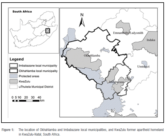
Imbabazane local municipality was merged with uMtshezi local municipality in August 2016 to form Inkosi Langalibalele local municipality. However, for this study, Imbabazane local municipality boundaries were used to match the 2014 observation point of this study (before merging). Okhahlamba and Imbabazane local municipalities had population sizes of 132 068 and 113 073, respectively, in 2011.35 Unemployment remains high at 43.4% and 48.6% in OLM and ILM, respectively.35 Black people dominate these areas, with Zulu being the primary spoken language. Land tenure is administered by the Ingonyama Trust and local authorities govern the use of the landscapes.
Remote sensing data
Image acquisition
Landsat imagery was used to map land cover in OLM and ILM. Winter (August) images were used as they have low atmospheric noise (such as clouds) that may obscure the earth surface. The images were obtained from the USGS website36, with geometric corrections already performed on these images. Images for path 168 and row 80 were obtained as they cover the study areas in one scene. Three observation points were chosen - 1984, 1991 (Landsat 4-5 TM), and 2014 (Landsat 8 OLI) - and images that correspond to the observation points were obtained. The three observation points were chosen to assess land cover in the early stages of municipal development, giving a baseline land cover (1984), development that might have been impacted by apartheid laws (1991), and development post-apartheid (2014). While the socio-economic and political factors would not have been the only drivers of land cover change, factors such as topography and climate would have remained constant, with the predominant driving influences of change being socio-economic/political. The selected observation points allow for analysing the influence of socio-economic and political factors on land use/ land cover change in marginalised landscapes of South Africa.
Image pre-processing
Although the acquired images had negligible cloud interference, image preprocessing of the Landsat images was conducted prior to classification. Radiometric correction followed by atmospheric correction (using the FLAASH tool) was done in ENVI v5.3 to remove all the noise that might have resulted due to atmospheric interference from clouds.
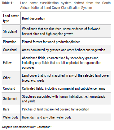
Land cover classification
The classification system by Thompson37 was revised and used to define land cover categories in this study (Table 1). Random forest classification was used to classify the pixels on the image using R studio v1.1.456 (Raster, rgdal, caret, e1071 and RandomForest packages were used). A minimum of 50 points per class were used to train the random forest classifier model. The output pixelated classified image was then scripted into QGIS v2.18 to classify the different land cover categories by pixel value. Any misclassified pixels were manually assigned to the correct land cover type.
Accuracy assessment was conducted using a combination of aerial photographs, Google Earth, and ground truthing during site visits in January 2019. A minimum of 50 points per land cover category were used for accuracy assessment. The overall accuracy of the classified images ranged from 87% to 90% (Supplementary table A1). User and producer accuracy assessment was also calculated for the individual classes using contingency tables (Supplementary tables A2 and A3).
Land cover change analysis
Protected areas were removed from the analysed images of the two local municipalities in uThukela Municipal District to avoid skewing the data towards high persistence of natural land cover categories. The area removed covered 515 km2 (13%) in OLM and 405 km2 (29%) in ILM.
Land cover change was analysed using transition matrix and intensity analysis which uses statistical methods to depict the patterns of land cover change over time.38,39 The detailed description of these methods is explained in the mentioned references and thus will not be repeated; however, the equations and cross-tabulation template used in this paper are attached as supplementary information (Appendix B). Intensity analysis considers the size of each class and accounts for the number of years in each time interval; thus, the gap between observation points does not affect the analysis process. This method further analyses the data in three levels. The first level is the interval level, which analyses the overall change in the landscape against a uniform change. The change can be categorised as fast or slow compared to the uniform change. The second level is the category level, which assesses the intensity of gain and loss for each land cover category. Gain or loss intensity can be categorised as active or dormant against a uniform intensity. The third level is the transitional level, which analyses the transition of each land cover category from one class to the other and depicts whether a category was targeted or avoided during the changes in the landscape for a particular period. The intensity analysis was performed using the IntensityAnalysis03 Excel software.40
Socio-economic and political data
Socio-economic and political data were used to further the understanding of factors influencing patterns in land cover change. Socio-economic data were obtained from Statistics South Africa (Stats SA) and household interviews were used to gain insight into people's perception of the changes in the case study municipalities. Data on population sizes were used to account for the population change of the entire municipality. Household surveys in the form of questionnaires (open-ended questions) were used to collect socio-economic data during site visits (January 2019). A total of 30 households (/7=30) were interviewed per municipality, resulting in a total of 60 participant households. The interviews were targeted at people who had resided in the area for at least 30 years to provide a general overview of the land use and land cover change over time. A referral approach was used, in which a member of the tribal authority was appointed to assist in identifying the participants in the area. Even though a referral approach may be biased towards people with whom the appointed member has good relations, the interviews conducted still reflected the perceptions of the local people residing in the area. The questions asked revolved around people's perception of the landscape integrity (degraded or not) and the role of the local authority regarding land use and tenure.Ethical clearance for the study was granted by the University of the Witwatersrand's Human Research Ethics Committee (reference number H180623).
The analysis of the household surveys data was done using a thematic approach in which responses were grouped into themes. This approach was used to have numerical proportion of response that can be visually presented in the form of a graph. The analysis of the data was performed in Microsoft Excel v.2112.
Results
Land cover
The land cover maps generated for ILM and OLM showed that grassland was the dominant land cover category (Figures 2 and 3), covering 75.5%, 88.7% and 79.5% over the analysis periods in ILM (Figure 4a). In OLM, grassland covered 84.8%, 83.6% and 78.4% over the analysis period (Figure 4b). Commercial farming represented by irrigated croplands was prominent in OLM (2.4% in 2014) compared to ILM (0.4% in 2014); however, the category showed an increasing trend in percentage cover in both local municipalities (Figure 4).
Systematic pattern of land cover change
The landscape in ILM experienced a total change of 23.7% between 1984 and 1991 and 21.4% between 1991 and 2014 (Table 2). Swapping contributed a total of 9.1% to the total change between 1984 and 1991 and 12.4% between 1991 and 2014. Between 1984 and 1991, cropland and settlement transformed 0.3% and 0.1% of grassland, respectively; however, grassland persistence (62.3%) remained high (Supplementary table C1). Between 1991 and 2014, 1.9% and 0.3% of grassland was transformed to settlement and cropland, respectively, indicating settlement and agricultural expansion (Supplementary table C2). In OLM, a total change of 21.7% (1984-1991) and 24.5% (1991-2014) was experienced (Table 3). Swapping contributed 18.2% between 1984 and 1991, and 17.3% between 1991 and 2014. Between 1984 and 1991, 0.2% of grassland was transformed to settlement and 0.6% to cropland. Grassland persistence (69.9%) remained high during this period (Supplementary table C3).
Between 1991 and 2014, cropland transformed 1.3% of grassland while settlement transformed 0.3% of this land cover (Supplementary table C4).
Intensity analysis
Interval level
In ILM, the uniform change was 1.5% and the calculated intensity of change at interval level was 3.4% (1984-1991) and 0.9% (1991-2014), indicating a fast change between 1984 and 1991 (Figure 5a). In OLM, the uniform change was also 1.5% and calculated intensity of change was 3.1% (1984-1991) and 1.1% (1991-2014), indicating a fast change between 1984 and 1991 (Figure 5b).
Category level
The category level analysis showed similar patterns of gains and loss for both local municipalities. The uniform intensity of gain/loss was 3.4% (1984-1991) and 0.9% (1991-2014) in ILM. All land cover categories, except for grassland, gained actively for both time periods (Figure 6). Settlement and grassland loss was dormant in both time periods, while the other land cover categories showed active loss. Cropland gain/loss intensity was active in both time periods, even though this land cover category covered a small portion of the landscape.
In OLM, the uniform intensity of gain/loss was 3.1% (1984-1991) and 1.1% (1991-2014). Grassland gain/loss was dormant for both time periods against the uniform intensity (Figure 7). Settlement gain/loss was active against the uniform intensity for both time periods (Figure 7b). Cropland gain/loss was active for both time periods. The other land cover categories' gain/loss intensity was active against the uniform intensity for both time periods, except for 'Water body' which was dormant between 1984 and 1991.
Transition level
The analysis in ILM showed that grassland was mainly transitioned to cropland and fallow between 1984 and 1991 (Supplementary table D1), and cropland only between 1991 and 2014. Settlement encroached into bare areas during this period, while cropland encroached into fallow and 'other'. Cropland was changed to fallow during both time periods, indicating large-scale rotational farming amongst different crop fields.
In OLM, grassland was mainly transitioned to bare, shrubland, fallow and 'other' between 1984 and 1991 (Supplementary table D2). Cropland encroached into fallow, bare, 'other' and plantation for the same period, while fallow replaced cropland. Between 1991 and 2014, cropland was replaced by fallow, while fallow also transitioned to cropland during the same period. Settlement targeted bare during this period.
Socio-economic and political factors
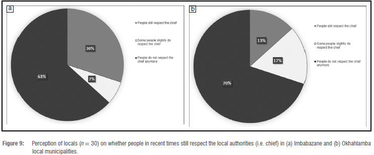
There was a general perception that the function of the landscapes in the two local municipalities are degraded, with 77% and 70% of the participants perceiving the landscape as degraded in ILM and OLM, respectively (Figure 8). There was also a perceived degradation of power of the local authorities in both local municipalities under focus. Over 60% of the locals perceived that people no longer respect the chief (Figure 9). Moreover, the respondents expressed that locals do not follow cultural practices like they used to before 1994 (Supplementary tables E1-E2).
The population numbers in both OLM and ILM declined during the census period (Figure 9), indicating movement of people out of the local municipalities. Overall population declines of 4.7% and 2% were observed in ILM and OLM, respectively, between 2001 and 2016. Although the population numbers declined, the locals perceived the number of homesteads to have increased (Supplementary tables E1-E2).
Discussion
We anticipated a substantial reduction in natural vegetation, together with an increased rate of conversion from natural to anthropogenic land cover over the study period. However, the results of our study were contrary to expectations in a marginalised landscape. The annual change area was reduced by 2.5% and 2% in ILM and OLM, respectively, during the analysis period, which is similar to trends observed in other parts of the world41, including KwaZulu-Natal33. We expected the rate of change to increase post-apartheid, given that people have the freedom to use the landscapes around them, together with introduction of governmental development programmes such as the Integrated Development Plan. The observed changes show high persistence of grassland, indicating its ability to withstand human impacts. One of the reasons that could be driving the persistence of grassland is the reduced use of the landscapes by villagers, given that there is a general perception that the landscapes in the two local municipalities are degraded (Figure 8). Moreover, the movement of people (outmigration) to the cities has resulted in a reduced population (Figure 10), which coincides with the reduced rate of land cover conversion during the analysis period.
Local authorities such as the chief and headman were previously responsible for managing land tenure and use in rural communities in South Africa.7,27 These structures are still present; however, there is a perceived degradation of the local authority's power over land use in the studied municipalities (Figure 9). This notion is observed in other rural areas such as Bushbuckridge in South Africa.7 Reduced influence on land tenure and use by the local authorities has implications for land cover change because locals have a level of freedom to use the landscapes around them in a way that benefits them. For example, harvesting of non-timber forest products could be high and unregulated, and thus leading to loss of natural ecosystems, as seen by the reduced grassland cover in our study area between 1991 and 2014.
The overall land cover change showed an increase in the spatial extent of cropland and settlement in both local municipalities. Settlement and cropland encroached into grassland patches; however, grassland remained persistent during the analysis period. Overall, grassland net change was higher in the first period compared to the second period in ILM, characterised by a high swapping phenomenon and a loss of 3.7% and 14.3% in both observation periods, respectively. Similar to ILM, grassland had a high swapping phenomenon in OLM and a loss of 10.2% and 13.3% in both observation periods, respectively. Although the loss of grassland was high in the recent time periods, the rate in which the conversion was taking place was dormant in both local municipalities. The slow rate of change could partly be explained by the swapping phenomenon, which represents a spatial change in grassland cover where a loss in one location results in a gain in a different location in the landscape, creating a steady loss rate. Encroachment by settlement and cropland on grassland has important ecological implications for the local municipalities in uThukela Municipal District because it can lead to ecological crisis, such as habitat and biodiversity loss.33,42 Apart from biodiversity loss, disturbing grassland can destabilise the ecosystem's composition and function. Grasslands provide important ecosystem services that are vital for maintaining the primary function of the ecosystem. These services include providing habitats for flora and fauna and regulating atmospheric carbon through carbon sequestration.43 The results of our study show high spatial persistence of grassland ecosystems in uThukela with over 60% of grassland being persistent throughout the study period (Supplementary tables D1-D4). The quality of these patches was not assessed in this study and thus we cannot comment on the quality, species richness and composition in these patches because the regrowth of secondary grassland occurred in fallow lands; however, local people in the communities perceive the landscapes to have become degraded. Secondary grasslands are associated with low forb species richness and are slower to return to the natural state.44 Future research is needed to determine how long it takes for secondary grassland to return to natural grassland to understand the impact of land cover change on grassland biodiversity.
Grasslands play a vital role in the livelihoods of rural communities by providing important natural resources necessary to sustain rural populations. Provision of wild fruits, vegetables, grazing land, and medicinal plants are some of the key natural resources obtained from grasslands. Local people rely on natural resources such as non-timber forest products to diversify their livelihoods and generate income to alleviate poverty.1,2,45 Thus, transforming grasslands can hinder rural livelihood diversification by reducing areas where resources can be harvested in ILM and OLM, forcing people into a 'red loop' where products are bought in the market instead of being harvested.22,46 The observed reduction in the rate of change post-apartheid potentially indicates that locals are less reliant on land-based strategies to sustain their livelihoods in rural South Africa in recent times. Ragie et al.47 showed that there is a shift towards off-farm income generation in Bushbuckridge, South Africa, suggesting that rural communities substitute practices such as farming with other income-generating activities such as social grants, remittances, and wage labour. Moreover, competition between uses of communal land for grazing and cultivation could limit the extent of expansion of cropland, which can be a source of local conflict between farm owners and local land users.
The results of the land cover change over the 30-year period show an overall increase in human-induced land cover categories. These results are similar to those of other studies in communal landscapes whereby human-induced land cover categories such as settlement have expanded over time8,9, resulting in reduced and fragmented natural vegetation near built-up areas. Although the drivers of change were not assessed, the results in this study show that settlement and cropland contributed to grassland loss in OLM and ILM. Built-up, commercial agriculture and mining activities have been observed to be the drivers of natural vegetation loss in KwaZulu-Natal.33 In other parts of South Africa such as the Kruger to Canyons Biosphere Reserve, intact natural vegetation declined by 6.8% whereas settlement increased by 39.7% between 1993 and 2006.8 In Bushbuckridge municipality (found in Gazankulu and Lebowa former homeland), woodland declined while settlement and cropland increased between 1965 to 2009.48 Land cover associated with green space (natural vegetation) declined over a 22-year period in an urban settlement space in eThekwini municipality, KwaZulu-Natal.49 These findings concur with our results, indicating that anthropogenic activities shape the landscapes in rural and urban areas, leading to natural vegetation loss and land cover change.
Cropland and fallow swapping occurred due to large-scale rotational farming and field abandonment. Field abandonment is one of the most debated processes in South Africa, especially in former Bantustan areas.50
At fine scales such as village level, subsistence farming has drastically declined over time in South African Bantustans.30-32 Factors that drive cropland abandonment at village scale are similar across South African Bantustans and they include lack of human resources, limited equipment to farm, infertile soil and drought.30-32 This is no different for the villages in OLM and ILM; however, locals in uThukela Municipal District are shifting towards home gardens rather than owning a big crop field. Shifting towards gardens has also been observed in Transkei and Ciskei former homelands in South Africa.32 The analysis of the Landsat imagery in this study does not capture this transition because of its resolution, which is a limitation when attempting to understand fine scale patterns of change. This emphasises the importance of considering scale, site visits and conducting semi-structured interviews when assessing land use and land cover change.
The results of this study expand on the existing knowledge of land use and land cover change in South Africa, indicating that the patterns of land use and land cover change are similar across all marginalised landscapes in the country despite the differences in geographic locations. The rate of change was higher in the first time period (i.e.1984-1991) in which total changes of 23.7% and 21.7% of the landscapes were observed in ILM and OLM, respectively. The first time period coincides with the early establishment of the municipalities during the apartheid era in the province and one would expect that some form of development would take place. The drivers of change were not assessed in this study, and thus future studies should seek to understand the drivers of land cover change such as climate, settlement expansion, socio-economic and political factors and mine area expansion.
Conclusion
Landscape transformation was higher in the observation period between 1984 and 1991, but low for the observation period 19912014. This can be attributed to rapid development in the early developmental stages of the municipalities, with land use change becoming steady and stable in recent times. Grassland was observed to be persistent in both landscapes, regardless of a loss in both local municipalities. The loss of grassland was dormant throughout the study period, partly due to high swapping phenomenon. Commercial agriculture and settlements encroach in the matrix of these patches. We cannot conclude the drivers of change and quality of the grassland because it was not assessed; however, secondary grassland regrew in previously farmed areas and the landscapes were perceived to be degraded by the local communities. Future research is needed to assess the drivers of land cover change and time span of the transition between secondary and natural grassland in previously farmed areas to understand the influence of socio-economic and political changes on land use and land cover change and its impact on biodiversity and ecosystem services in rural areas.
Acknowledgements
We thank Mr Bheki Radebe for providing expert knowledge of the landscapes in uThukela Municipal District during the ground truthing exercise. We also thank the reviewers for their constructive feedback on the manuscript. This project was funded by the South African National Research Foundation (NRF) Thuthuka Grant (99289) and DAAD-NRF In-Country Master's and Doctoral Scholarships Programme (reference no. SFH180514329246).
Competing interests
We have no competing interests to declare.
Authors' contributions
B.P.M.: Conceptualisation, methodology, software, validation, formal analysis, investigation, data curation, writing - initial draft, visualisation, project administration, funding acquisition. D.J.: Conceptualisation, methodology, validation, writing - review and editing, supervision. J.T.F.: Conceptualisation, methodology, validation, resources, writing - review and editing, supervision, funding acquisition. D.F.: Validation, writing -review and editing. All authors read and agreed to submission of the final version of the manuscript.
References
1. Shackleton C, Shackleton S. The importance of non-timber forest products in rural livelihood security and as safety nets: A review of evidence from South Africa. S Afr J Sci. 2004;100(11):658-664. [ Links ]
2. Shackleton S, Delang CO, Angelsen A. From subsistence to safety nets and cash income: Exploring the diverse values of non-timber forest products for livelihoods and poverty alleviation. In: Non-timber forest products in the global context. Springer; 2011. p. 55-81. https://doi.org/10.1007/978-3-642-17983-9_3 [ Links ]
3. Gibbs HK, Ruesch AS, Achard F, Clayton MK, Holmgren P Ramankutty N, et al. Tropical forests were the primary sources of new agricultural land in the 1980s and 1990s. Proc Natl Acad Sci USA. 2010;107(38):16732-16737. https://doi.org/10.1073/pnas.0910275107 [ Links ]
4. Reid RS, Kruska RL, Muthui N, Taye A, Wotton S, Wilson CJ, et al. Land-use and land-cover dynamics in response to changes in climatic, biological and socio-political forces: The case of southwestern Ethiopia. Landsc Ecol. 2000;15(4):339-355. https://doi.org/10.1023/A:1008177712995 [ Links ]
5. Mapedza E, Wright J, Fawcett R. An investigation of land cover change in Mafungautsi Forest, Zimbabwe, using GIS and participatory mapping. Appl Geogr. 2003;23(1):1-21. https://doi.org/10.1016/S0143-6228(02)00070-X [ Links ]
6. Kiage L, Liu KB, Walker N, Lam N, Huh O. Recent land-cover/use change associated with land degradation in the Lake Baringo catchment, Kenya, East Africa: Evidence from Landsat TM and ETM+. Int J Remote Sens. 2007;28(19):4285-4309. https://doi.org/10.1080/01431160701241753 [ Links ]
7. Kirkland T, Hunter LM, Twine W. "The bush is no more": Insights on institutional change and natural resource availability in rural South Africa. Soc Nat Resour. 2007;20(4):337-350. https://doi.org/10.1080/08941920601161353 [ Links ]
8. Coetzer KL, Erasmus BF, Witkowski E, Bachoo AK. Land-cover change in the Kruger to Canyons Biosphere Reserve (1993-2006): A first step towards creating a conservation plan for the subregion. S Afr J Sci. 2010;106(7-8), Art. #221. https://doi.org/10.4102/sajs.v106i7/8.221 [ Links ]
9. Coetzer KL, Erasmus BF, Witkowski ET, Reyers B. The race for space: Tracking land-cover transformation in a socio-ecological landscape, South Africa. Environ Manage. 2013;52(3):595-611. https://doi.org/10.1007/s00267-013-0094-9 [ Links ]
10. Burgoyne C, Kelso C, Ahmed F. Human activity and vegetation change around Mkuze Game Reserve, South Africa. S Afr Geogr J. 2016;98(2):217-234. https://doi.org/10.1080/03736245.2015.1028978 [ Links ]
11. Pullanikkatil D, Palamuleni LG, Ruhiiga TM. Land use/land cover change and implications for ecosystems services in the Likangala River Catchment, Malawi. Phys Chem Earth. 2016;93:96-103. https://doi.org/10.1016/j.pce.2016.03.002 [ Links ]
12. Pullanikkatil D, Palamuleni L, Ruhiiga T. Assessment of land use change in Likangala River catchment, Malawi: A remote sensing and DPSIR approach. Appl Geogr. 2016;71:9-23. https://doi.org/10.1016/j.apgeog.2016.04.005 [ Links ]
13. Dovie DB, Witkowski E, Shackleton CM. The fuelwood crisis in southern Africa-relating fuelwood use to livelihoods in a rural village. GeoJournal. 2004;60(2):123-133. https://doi.org/10.1023/B:GEJO.0000033597.34013.9f [ Links ]
14. Wessels KJ, Colgan M, Erasmus BFN, Asner G, Twine W, Mathieu R, et al. Unsustainable fuelwood extraction from South African savannas. Environ Res Lett. 2013;8(1):014007. https://doi.org/10.1088/1748-9326/8/1/014007 [ Links ]
15. Twine WC, Holdo RM. Fuelwood sustainability revisited: Integrating size structure and resprouting into a spatially realistic fuelshed model. J Appl Ecol. 2016;53(6):1766-1776. https://doi.org/10.1111/1365-2664.12713 [ Links ]
16. Swemmer AM, Mashele M, Ndhlovu PD. Evidence for ecological sustainability of fuelwood harvesting at a rural village in South Africa. Reg Environ Change. 2019;19(2):403-413. https://doi.org/10.1007/s10113-018-1402-y [ Links ]
17. Vermeulen S, Campbell B, Mangono J. Shifting patterns of fuel and wood use by households in rural Zimbabwe. Energy Environ. 2000;11(3):233-254. https://doi.org/10.1260/0958305001500112 [ Links ]
18. Millennium Ecosystem Assessment. Ecosystems and human well-being: Health synthesis. Geneva: World Health Organization; 2005. [ Links ]
19. Feddema JJ, Oleson KW, Bonan GB, Mearns LO, Buja LE, Meehl GA, et al. The importance of land-cover change in simulating future climates. Science. 2005;310(5754):1674-1678. https://doi.org/10.1126/science.1118160 [ Links ]
20. Berkes F, Colding J, Folke C. Rediscovery of traditional ecological knowledge as adaptive management. Ecol Appl. 2000;10(5):1251-1262. https://doi.org/10.1890/1051-0761(2000)010[1251:ROTEKA]2.0.CO;2 [ Links ]
21. Cumming GS. Spatial resilience: Integrating landscape ecology, resilience, and sustainability. Landsc Ecol. 2011;26(7): 899-909. https://doi.org/10.1007/s10980-011-9623-1 [ Links ]
22. Cumming GS, Buerkert A, Hoffmann EM, Schlecht E, Von Cramon-Taubadel S, Tscharntke T. Implications of agricultural transitions and urbanization for ecosystem services. Nature. 2014;515(7525):50-57. https://doi.org/10.1038/nature13945 [ Links ]
23. Wu K, Ye X, Qi Z, Zhang H. Impacts of land use/land cover change and socioeconomic development on regional ecosystem services: The case of fast-growing Hangzhou metropolitan area, China. Cities. 2013;31:276-284. https://doi.org/10.1016/j.cities.2012.08.003 [ Links ]
24. Karki S, Thandar AM, Uddin K, Tun S, Aye WM, Aryal K, et al. Impact of land use land cover change on ecosystem services: A comparative analysis on observed data and people's perception in Inle Lake, Myanmar. Environ Syst Res. 2018;7(1):25. https://doi.org/10.1186/s40068-018-0128-7 [ Links ]
25. McCusker B. Land use and cover change as an indicator of transformation on recently redistributed farms in Limpopo Province, South Africa. Hum Ecol. 2004;32(1):49-75. https://doi.org/10.1023/B:HUEC.0000015220.22795.27 [ Links ]
26. De Boer WF, Baquete DS. Natural resource use, crop damage and attitudes of rural people in the vicinity of the Maputo Elephant Reserve, Mozambique. Environ Conserv. 1998;25(3):208-218. https://doi.org/10.1017/S0376892998000265 [ Links ]
27. Twine W. Socio-economic transitions influence vegetation change in the communal rangelands of the South African lowveld. Afr J Range Forage Sci. 2005;22(2):93-99. https://doi.org/10.2989/10220110509485866 [ Links ]
28. Ramutsindela M. Resilient geographies: Land, boundaries and the consolidation of the former bantustans in post-1994 South Africa. Geogr J. 2007;173(1):43-55. https://doi.org/10.1111/j.1475-4959.2007.00230.x [ Links ]
29. Giannecchini M, Twine W, Vogel C. Land-cover change and human-environment interactions in a rural cultural landscape in South Africa. Geogr J. 2007;173(1):26-l2. https://doi.org/10.1111/j.1475-4959.2007.00227.x [ Links ]
30. Blair D, Shackleton CM, Mograbi PJ. Cropland abandonment in South African smallholder communal lands: Land cover change (1950-2010) and farmer perceptions of contributing factors. Land. 2018;7(4):121. https://doi.org/10.3390/land7040121 [ Links ]
31. Hebinck P Mtati N, Shackleton C. More than just fields: Reframing deagrarianisation in landscapes and livelihoods. J Rural Stud. 2018;61:323-334. https://doi.org/10.1016/j.jrurstud.2018.01.004 [ Links ]
32. Shackleton C, Mograbi P Drimie S, Fay D, Hebinck P Hoffman M, et al. Deactivation of field cultivation in communal areas of South Africa: Patterns, drivers and socio-economic and ecological consequences. Land Use Policy. 2019;82:686-699. https://doi.org/10.1016/jJandusepoL2019.01.009 [ Links ]
33. Jewitt D, Goodman PS, Erasmus BF, O'Connor TG, Witkowski ET. Systematic land-cover change in KwaZulu-Natal, South Africa: Implications for biodiversity. S Afr J Sci. 2015;111 (9-10), Art. #2015-0019. https://doi.org/10.17159/sajs.2015/20150019 [ Links ]
34. Mucina L, Rutherford M. The vegetation of South Africa, Lesotho and Swaziland. Strelitzia 19. Pretoria: South African National Biodiversity Institute; 2006. [ Links ]
35. Statistics South Africa (Stats SA). Statistics by place [webpage on the Internet]. c2011 [cited 2019 Feb 09]. Available from: https://www.statssa.gov.za/?page_id=964 [ Links ]
36. USGS. Viewer [webpage on the Internet]. No date [cited 2018 Mar 05]. Available from: https://earthexplorer.usgs.gov/ [ Links ]
37. Thompson M. A standard land-cover classification scheme for remote-sensing applications in South Africa. S Afr J Sci. 1996;92(1):34-42. [ Links ]
38. Pontius Jr RG, Shusas E, McEachern M. Detecting important categorical land changes while accounting for persistence. Agric Ecosyst Environ. 2004;101(2-3):251-268. https://doi.org/10.1016/j.agee.2003.09.008 [ Links ]
39. Aldwaik SZ, Pontius Jr RG. Intensity analysis to unify measurements of size and stationarity of land changes by interval, category, and transition. Landsc Urban Plan. 2012;106(1):103-114. https://doi.org/10.1016/j.landurbplan.2012.02.010 [ Links ]
40. Aldwaik SZ, Pontius Jr RG. IntensityAnalysis03 [software program]; 2009. [ Links ]
41. Minaei M, Kainz W. Land cover change dynamics based on intensity analysis in gorganrood watershed, Iran. J Agric Sci Technol. 2018;20(5):965-978. [ Links ]
42. Sala OE, Chapin FS, Armesto JJ, Berlow E, Bloomfield J, Dirzo R, et al. Global biodiversity scenarios for the year 2100. Science. 2000;287(5459):1770-1774. https://doi.org/10.1126/science.287.5459.1770 [ Links ]
43. Bengtsson J, Bullock JM, Egoh B, Everson C, Everson T, O'Connor T, et al. Grasslands - more important for ecosystem services than you might think. Ecosphere. 2019;10(2):e02582. https://doi.org/10.1002/ecs2.2582 [ Links ]
44. Zaloumis NP Bond WJ. Grassland restoration after afforestation: No direction home? Austral Ecol. 2011;36(4):357-366. https://doi.org/10.1111/j.1442-9993.2010.02158.x [ Links ]
45. Shackleton CM, Shackleton SE. Household wealth status and natural resource use in the Kat River valley, South Africa. Ecol Econ. 2006;57(2):306-317. https://doi.org/10.1016/j.ecolecon.2005.04.011 [ Links ]
46. Hamann M, Biggs R, Reyers B. Mapping social-ecological systems: Identifying 'green-loop' and 'red-loop' dynamics based on characteristic bundles of ecosystem service use. Glob Environ Change. 2015;34:218-226. https://doi.org/10.1016/j.gloenvcha.2015.07.008 [ Links ]
47. Ragie FH, Olivier DW, Hunter LM, Erasmus BF, Vogel C, Collinson M, et al. A portfolio perspective of rural livelihoods in Bushbuckridge, South Africa. S Afr J Sci. 2020;116 (9-10), Art. #7522. https://doi.org/10.17159/sajs.2020/7522 [ Links ]
48. Matsika R. The spatio-temporal dynamics of woody biomass supply and demand in response to human utilisation in an African savanna woodland [PhD thesis]. Johannesburg: University of the Witwatersrand; 2012. [ Links ]
49. Otunga C, Odindi J, Mutanga O. Land use land cover change in the fringe of eThekwini Municipality: Implications for urban green spaces using remote sensing. S Afr J Geomat. 2014;3(2):145-162. https://doi.org/10.4314/sajg.v3i2.3 [ Links ]
50. Mkhongi FA, Musakwa W. Trajectories of deagrarianization in South Africa - Past, current and emerging trends: A bibliometric analysis and systematic review. Geogr Environ Sustain. 2022;3(4):325-333. https://doi.org/10.1016/j.geosus.2022.10.003 [ Links ]
 Correspondence:
Buster Mogonong
Email: b.p.mogonong@gmail.com
Received: 13 Apr. 2021
Revised: 06 Feb. 2023
Accepted: 17 Apr. 2023
Published: 08 Aug. 2023
Editor: Sydney Moyo
Funding: South African National Research Foundation (99289; SFH180514329246)

