


Services on Demand
Article
 English (pdf)
 Article in xml format
 Article references
Indicators

Related links
-
 Cited by Google
 -
 Similars in Google
Share

 Permalink
South African Journal of Science
On-line version ISSN 1996-7489
Print version ISSN 0038-2353
S. Afr. j. sci. vol.118 n.11-12 Pretoria Nov./Dec. 2022
http://dx.doi.org/10.17159/sajs.2022/14020
RESEARCH ARTICLE
Lifting back the waters: Marine geophysics provides new insights into the uThukela Banks Marine Protected Area
Andrew N. GreenI, II; Luke D. EngelbrechtI; Kerry SinkIII, IV; Christine F. MackayV, VI; Sean T FennessyV, VI; Kathrine MichalsenVII
IGeological Sciences, University of KwaZulu-Natal, Durban, South Africa
IIEnvironmental Sciences Research Institute, University of Ulster, Coleraine, Northern Ireland, UK
IIICentre for Biodiversity Conservation, South African National Biodiversity Institute, Cape Town, South Africa
IVInstitute for Coastal and Marine Research, Nelson Mandela University, Gqeberha, South Africa
VOceanographic Research Institute, Durban, South Africa
VISchool of Life Sciences, University of KwaZulu-Natal, Durban, South Africa
VIIInstitute of Marine Research (IMR), Bergen, Norway
ABSTRACT
Using the first high-resolution geophysical data set collected from the uThukela Banks Marine Protected Area (MPA), we reveal a plethora of hitherto unknown or poorly resolved seabed features. In tandem with several remotely operated vehicle dives, we improve on the previous National Biodiversity Assessment map for the area and reveal a more complex picture of the seabed geology and geomorphology on which the MPA is predicated. The upper slope (-120 m and deeper) is dominated by small canyons, gullies and rills that occasionally extend to the shelf edge and form a series of slumps. Suspected cold-water corals were imaged on the interfluves of the Thukela Canyon. The mid to outer shelf (-60 to -100 m) is mostly rocky, and is composed of Pliocene-age siltstones for the most part. Aeolianite shorelines are found at depths of 60 m and 100 m, in which palaeo-lagoons and parabolic aeolian dune systems are also preserved. These features provide habitat for mesophotic corals and demersal fishes. Overlying and abutting hard rock substrates are unconsolidated sandy sediments that are mobilised by the inshore movement of the Agulhas Current. An inshore mud belt characterised by pockmarks associated with free gas expulsion is mapped for the first time. A well-developed palaeo-drainage pattern is also revealed, posing exciting new opportunities for the study of benthic communities associated with palaeo-estuaries and lagoons now exposed at the seabed. Several new habitats, both inside and out of the MPA boundaries, should form the basis for future research within the MPA, in addition to informing expansions of the MPA.
SIGNIFICANCE:
• Using a newly collected geophysical data set, we provide an unprecedented glimpse into the newly proclaimed uThukela Banks Marine Protected Area.
• We reveal a complexity of marine habitats hitherto unknown from previous biodiversity surveys. These habitats include areas of possible expansion given the recognition of keystone species that occur just outside the MPA limits.
Keywords: multibeam bathymetry, seismic reflection, Marine Protected Area, benthic habitats
Introduction
The 2019 proclamation of 20 new Marine Protected Areas (MPAs) for South Africa heralded a major step forward in the protection of its offshore marine ecosystems, biodiversity and resources. Despite an ambitious increase from 0.4% to 5% in the protection of South African marine and coastal habitats, little is known of the sediment ecology, geology and geomorphology of these areas. Where biological information has limited spatio-temporal resolution, geophysical seafloor attributes may be used as surrogates for ecological processes and species distribution.1 However, despite the acknowledged strong linkages between offshore geology, geomorphology and benthic species distribution1, South African MPAs still lack high-resolution geological maps and substrate interpretations. Such knowledge has become increasingly critical for marine spatial planning, including MPA design, implementation, management and expansion in many nations where seabed mapping forms an integral part of such efforts.
The uThukela Banks was identified as a priority area for conservation, based on multiple systematic conservation plans including the Offshore MPA project initiated in 2006.2 This project used 576 data layers and systematic conservation planning, together with an adaptive stakeholder process to identify priority areas for offshore protection, following which the uThukela MPA was promulgated3 through a Presidential Oceans Economy Initiative known as Operation Phakisa4. The purpose of the uThukela MPA is to protect interconnected coastal, shelf and slope ecosystems, inclusive of sandy, gravelly, reef and submarine canyon habitats.3 The conservation and protection of ecologically sensitive biodiversity and associated ecological processes is underpinned by vulnerable coral and sponge habitats; threatened species and ecosystems; connectivity pathways; spawning areas; and nurseries. The protected and threatened species include marine mammals (e.g. Sousa plumbea), turtles (e.g. Caretta caretta), hammerhead sharks (Sphyrna spp.), as well as overexploited fisheries species including several species of endemic seabreams (Sparidae), geelbek (Atractoscion aequidens), squaretail kob {Argyrosomus thorpei), and garrick (Lichia amia). The MPA also protects areas of life-history importance for several harvested crustacean species (e.g. Penaeus indicus, Haliporoides triarthrus) and for migratory fish species.
The complexity of habitat features in any given area is one of the factors that influences both the diversity and the species present, and in turn thus influences the efficiency of no-take MPAs in protecting these species.5 The area initially identified for protection on the uThukela Banks extended beyond the shelf edge to depths of more than 1000 m, inclusive of the Thukela Canyon, the largest submarine canyon in the area.6
In this paper, we present an unprecedented variety of seafloor features comprising unique offshore habitats on the eastern margin of South Africa. These are revealed with a newly acquired geophysical data set, the first from the area since the regional surveys of the 1980s.7 Using multibeam bathymetric and seismic reflection data, together with direct observational data collected by a remotely operated vehicle (ROV), we reveal the first high-resolution interpretations of the seabed of the uThukela Banks MPA and illustrate advances made in knowledge of the seafloor habitats of the area. We further highlight newly discovered seabed habitats from areas adjacent to the MPA, some of which may broaden the scope for its future expansion, including areas since removed from the original MPA design. The information we provide will thus feed directly into future iterations of Marine Ecosystems and Mapping for the National Biodiversity Assessment8 as well as inform national marine spatial planning initiatives9, and ecosystem-based approaches to fisheries management10.
Regional setting
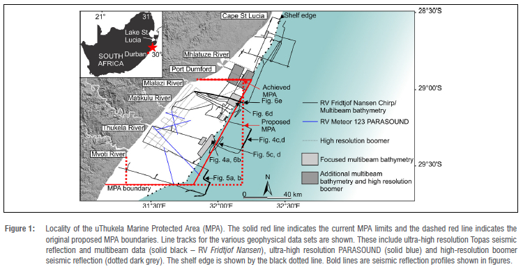
The uThukela Banks MPA is situated on the continental shelf of the KwaZulu-Natal (KZN) Bight between Durban and Richards Bay (Figure 1) and spans an area of ~ 4094 km2. The area has the widest shelf on the east coast of South Africa, with a large fluvial sediment source to landward, and is swept by the vigorous southerly-directed Agulhas Current along its seaward fringes.11 The benthic habitat is shaped by flows of sediments and nutrients that stem from the coastline and the uThukela River12-14, while the overlying water column and biota are nourished by the upwelling along the shelf edge and inshore eddy systems15,16. Sediment is also supplied to the shelf by the in situ breakdown of several aeolianite palaeo-shorelines that span the MPA.11 These aeolianites provide the most prominent topographic features of an otherwise flat seabed7, and they contribute significantly to the area's biological importance and productivity from a habitat and nutrient perspective17-19.
Abutting and surrounding these aeolianite palaeo-shorelines are sandy sediments that become progressively muddier with proximity to the coastline; these constitute the submerged portions of the wave-dominated Thukela delta.20 Despite the large quantities of sediment delivered to the shelf, it is comparatively sediment starved when compared to other shelves of the world12 and much of the mid shelf has been considered to comprise palimpsest gravels, or muds from palaeo-lagoons, exposed by erosion during rising sea levels11. These create niche habitats for a variety of benthic organisms not found in comparable quantities elsewhere in South Africa. These organisms include penaeid prawns21; fishes favouring turbid, soft-bottom habitats22; and infauna that have adapted to fluvial inputs of sediment and detritus, by switching between deposit and suspension feeding depending on the timing of particulate organic matter delivery23. Offshore the uThukela River, there are high abundances of hermit crabs (Paguristes sp.); these crabs are scavengers that proliferate during high river outflow, making use of the shells of carnivorous Bullia similis snails.24
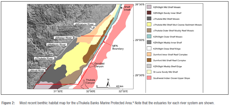
Based on the above, the area within the MPA has been classified into several distinct ecosystem types (Figure 2; Table 1).8 These include a variegated mix of unconsolidated sediments in the mid shelf (KZN Bight and uThukela Shelf Mosaics), a large area of mixed mud and coarse sediment (uThukela Mid Shelf Mud Coarse Sediment Mosaic) and an inner muddy shelf (KZN Bight Muddy Inner Shelf). The shelf edge and upper slope are considered muddy (KZN Bight Outer Shelf Mosaic, KZN Bight Muddy Shelf Edge, and uThukela Outer Shelf Muddy Reef Mosaic). Based on a series of seafloor grabs to 200 m depth11, muds concentrate mostly in the southern portions of the MPA offshore the uMvoti Estuary and give way to coarser sandy and gravelly material in the central and northern areas. The slope is also incised by two canyons, the Thukela and Goodlad Canyons25, although the locations of their heads have not been accurately constrained.
Two main reef complexes are identified, the Durnford inner shelf and outer shelf reefs, separated from each other by sandy sediments of the St Lucia sandy mid shelf (Figure 2). These form a southward extension of the prominent subaqueous dunes of northern KwaZulu-Natal formed by the Agulhas Current.26,27
Methods
Approximately 2000-line km of ultra-high resolution Topas PS18 seismic reflection profiles and multibeam bathymetry were collected between 31 January and 6 February 2018 aboard the RV Dr. Fridtjof Nansen (Figure 1). These spanned the southern portions of the uThukela Banks MPA, up to Cape St Lucia and covered an area of 3400 km2, the purpose of which was to examine key habitat features in the now promulgated MPA, identified by other authors in the planning stages. Seismic reflection data were collected using a Chirp trigger, and were processed using the Kongsberg SBP utility where the final product resolves to < 20 cm in the vertical. Several dedicated blocks of multibeam bathymetry were collected, spanning an area of ~ 180 km2 of which we present 160 km2 from the mid to outer shelf and upper slope of the MPA (Figure 1). Multibeam bathymetry was collected using the deep-water Kongsberg EM302 and shallow-water EM710 systems. Sound velocity variations due to salinity and temperature were modelled using a Seabird 911 conductivity-temperature-depth (CTD) sensor. All data were positioned with a differential GPS system of <1 m accuracy. Bathymetry data were processed using Beamworx, where spurious soundings were removed and the data reduced to mean sea level using South African Navy tide charts.28
These geophysical data were supplemented with ultra-high resolution PARASOUND data and more recently acquired lower resolution seismic reflection data collected between 2018 and 2020.20 Groundtruthing of the various seabed features on the shelf was performed with a towed camera array aboard the RV Dr. Fridtjof Nansen, together with existing ROV footage and grab samples collected under various African Coelacanth Ecosystem Projects (ACEP Natal Bight, ACEP Surrogacy, ACEP Marine Spatial Solutions). Additional multibeam data offshore the port of Richards Bay, collected in 2009 and reported on by other authors29, were also included. Where rock samples were occasionally retrieved by grabs, these were examined using thin sections and petrographic microscopy. The entire data set was integrated with a lower resolution bathymetry grid of the upper slope30, to identify key pathways and connections between rivers, canyons and slope gullies in deeper waters.
Results and discussion
Outer shelf and slope
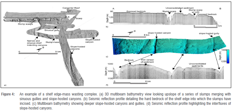
The uThukela MPA outer shelf is characterised by several slumps and mass wasting features (Figure 3 and Figure 4a). The slumps extend upslope to a rocky shelf edge with little to no sediment cover, forming a rugged and variable terrain at water depths of 100-150 m (Figure 4b). Although these are relatively small compared to slumps documented from elsewhere on the South African margin31,32, they no doubt provide a niche habitat for the area with the exposure of steep and rugged surfaces in the headscarps, and the transport of rocky debris into deeper waters usually dominated by mud. Such varied habitats influence biodiversity, and colonising organisms that themselves create structures that further increase habitat heterogeneity and biodiversity.33 The slump features may also pose new exploration sites for coelacanth.34 These features occur between two known living coelacanth habitats at Sodwana Bay35 and Mzumbe36, and at a depth similar to habitats reported elsewhere37.
Several newly mapped slope-hosted gullies and canyons are also evident from both the multibeam and seismic reflection data (Figure 4a, c and d). These form <150-m-wide linear depressions that incise 20-50 m into the seafloor (Figure 4c, d)). The gullies and canyons can be traced further seaward into ~2200 m of water30 (Figure 3). Where visible, these small canyons and gullies terminate in amphitheatre-shaped depressions along the slumped upper slope.
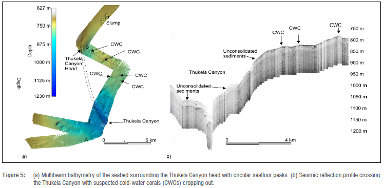
We identify only one large canyon in the area, the Thukela Canyon (Figure 5a). Our new data resolve the location of the canyon head more precisely than previous low-resolution depictions.38 It occurs in 755 m of water and gently transitions from the surrounding flat seafloor into a narrow 230-m-wide sinuous depression. The canyon head is significantly narrower than suggested in the National Biodiversity Assessment benthic habitat map8 and occurs outside of the current MPA limits. Given the importance of protection of submarine canyons as sensitive marine habitats, especially within the initial MPA proposal, this may be a key focal point for further seaward extension of the MPA. The Goodlad Canyon25,38 is not well resolved. The slope-hosted canyons and slumps shown in Figure 4 match the location reported38; however, their scale is much smaller, with a significantly narrower and less entrenched form to that previously thought25.
Seismic profiles of the mid slope are characterised by 10-50-m-thick, weakly stratified sediment from which several acoustically opaque bodies crop out (Figure 5b). These comprise circular to elongate seafloor features in the bathymetry and occur from -200 m to -800 m, notably straddling the interfluves of the Thukela Canyon on the mid slope (Figure 5b). Although not yet physically observed, they strongly resemble cold-water coral (CWC) accumulations observed by others from similar slope systems worldwide.39-42 Cold-water corals have a significant role in the zoning of MPAs in South Africa, notably as a keystone species8, and as long-lived sensitive, habitat-forming species they are global indicators of vulnerable marine ecosystems42. These possible new localities may thus prove of critical importance to any plans regarding the further seaward expansion of the uThukela Banks MPa.
Rocky features of the mid to outer shelf
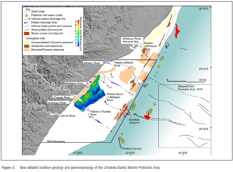
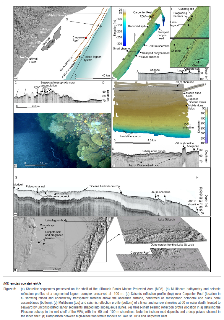
The mid to outer shelf appears to be characterised by mostly rocky outcrops that comprise Miocene- to Pliocene-aged siltstones43 over which Quaternary-aged aeolianites and beachrocks overlie (Figure 3). The aeolianites and beachrocks comprise a set of submerged shorelines that occur regularly at depths of 60 m, and 100 m (Figure 6a).
-100 m shoreline
The -100 m shoreline is characterised by a single, high relief (<11 m) and flat-topped ridge of aeolianite that is bordered to landward by a lower elevation seafloor (Figure 6). Directly seaward of the modern uThukela Estuary, and for over 12 km coast-parallel, the landward margin of the -100 m shoreline is backed by semi-circular seafloor depressions <2 m deep, separated by cuspate high points on which small 1.5-m-high prograded ridges of aeolianite have developed (Figure 6b). Several small, 230-m-wide and 1-m-deep, unfilled channels enter these depressions and extend to the shelf edge. The depressions have a <2-m-thick fill of acoustically opaque material (Figure 6b, section A-B).
Other authors44 have identified a set of morphologically and stratigraphically similar seafloor features from the Durban Shelf ~83 km to the southwest of this site, which they interpreted as a series of drowned lagoons, separated by cuspate spits in the back barrier on which small prograded barrier sequences have developed. Given the -100 m shoreline's remarkable similarity to these features, and when compared to high-resolution topographic data of the modern coastal waterbodies and dunes of the Maputaland coastline to the north45, we consider this seafloor feature a drowned lagoon (Figure 6f). This shoreline becomes progressively more linear northward, with small, 150 m-wide crenulations that are similar in appearance to the parabolic dune fields of northern KwaZulu-Natal.46
-60 m shoreline
Carpenter Reef is a large aeolianite complex that comprises the more landward part of the -60 m shoreline system rising to -49 m. It is characterised by a relief of between 20 m and 25 m (Figure 6b and c). To date, this is the largest and most prominent seafloor feature mapped on the uThukela Shelf, distinguished by several pinnacles and ridges, the latter of which form parabolic shapes like the contemporary parabolic dunes of the Maputaland coastline (Figure 6f). Comparisons with topographic data from the St Lucia region45 reveal a remarkable degree of similarity in both onshore and offshore geomorphology, and we consider the seafloor imaged in Figure 6b to be an analogue to the dune systems that border and enclose parts of the coastal waterbodies of the northern KwaZulu-Natal coast (e.g. Lake St Lucia). This shoreline is not well exposed south of the uThukela Estuary and is visible only in the seismic data.
ROV and drop camera transects reveal the -60 m shorelines to have a variety of encrusting mesophotic corals, including dense seafans (probably Astromuricea fusca), soft corals Parasphaerosclera aurea, dendrophyllid scleractinians47 and black corals of the genera Antipathes and Stichopathes (Figure 6c). These are shown in seismic reflection profiles to constitute domed, hyperbolic reflections that form the upper surface, with an acoustically transparent to weakly reflective signature. These mesophotic reefs also host a variety of demersal fishes important in the commercial and recreational linefishery, particularly several species of endemic seabreams (Sparidae), rockcod (Epinephelidae) and kobs (Sciaenidae).48,49
Soft sediments of the mid to inner shelf
A >40-km-long train of large subaqueous dunes occurs in the mid shelf areas of the MPA, bordered to landward by the -60 m shoreline (Figures 3 and 6d). These constitute the uppermost portions of a <10-m-thick, 900-m-wide package of unconsolidated sediment (e.g. Figure 6d, profile E-F). Sediment transport directions are exclusively from north to south, in agreement with the general flow direction of the Agulhas Current, and we consider these as evidence for an occasional, ~5 km in-shelf extension of the Current in the MPA from its usual position along the shelf break.27
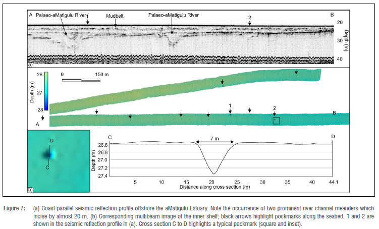
Most of the inner shelf is dominated by a <10-m-thick mud belt that spans the area offshore the uMvoti River to midway between the aMatigulu and uMlalazi Rivers (Figure 3).
Once supporting a shallow-water penaeid prawn fishery50, it is dominated by smaller sediment-dwelling species (mostly Polychaeta) that have a preference for carbon-rich, muddy environments24. Many of the taxa are rare distributions, providing unique biological traits23 that indicate food resource and habitat diversity51. The mud belt occurs between the 15-m and 30-m isobaths, bordered by Pliocene siltstone bedrock outcrop to landward and characterised by high frequency and low to moderate amplitude reflectors that drape the seafloor (Figures 6e and 7a). In the most landward portions of the mud belt, the seismic reflections are blanked (no clear internal stratification) due to the presence of significant quantities of free gas (likely methane) in the sediment.
The mud belt has a variety of gas expulsion pockmarks, evident from the multibeam bathymetry (Figure 7b). They are almost completely circular in shape with a maximum diameter of ~7 m and depths of up to 1 m. The pockmarks do not correspond to any gas chimney or escape features in the seismic data (Figure 7a) and are mostly found where the sediment is gas free or unblanked. This implies a relatively short retention time of the free gas in the sediments, and active gas release to the nearshore environment.
These are the first pockmarks to be recognised from the eastern shelf of South Africa. Despite significant emphasis on the importance of methane seeps from deep-water environments, notably those offshore the Western Cape52 and especially in the context of niche habitat provision8, there is nothing known about the habitats provided by these features in South African shallow coastal marine ecosystems. They thus provide an important avenue for future research in the uThukela Banks MPA.
Palaeodrainage
Several palaeo-channels (Figures 3 and 7) can be mapped from the seismic data and are tentatively correlated with the modern drainage patterns of the coast. A prominent palaeo-uThukela River crossed the shelf and appears to have diverted towards the uThukela Canyon head on the mid slope (Figure 3). The palaeo-iNyoni and aMatigulu Rivers merged in the mid shelf and can be traced into the -100 m submerged lagoon where they acted as the feeder valleys to the palaeo-lagoon system.
A few smaller channels are evident between the aMatigulu/iNyoni Estuary and the uMlalazi Estuary; from the existing data it is unclear where they cross the shelf edge. The palaeo-channel of the uMlalazi River is located directly seaward of the modern river and is only evident again in the mid shelf regions. In contrast, the palaeo-uMhlatuze River is very clearly revealed to cross the shelf directly seaward of the Richards Bay port entrance, bifurcating and then re-joining in the mid shelf as a single channel before terminating at the shelf edge. Many of these fluvial pathways were submerged by rising sea levels over the past 18-20 kyr 50, transforming into estuaries now exposed at the seabed due to limited sediment cover. Their exposure likely relates to increased degrees of sediment starvation of the shelf, especially along the outer shelf and at the shelf edge due to current winnowing by the Agulhas Current.11,53
Recent work has shown that these palaeo-fluvial courses, and especially exposed relict lagoons and estuaries, act as niche habitats for macrobenthic communities that are unexpected in the shelf environment. For instance, research underway54 indicates that these systems support remarkable infauna diversity, including endemic species that create biodiversity 'hot spots'. The palaeo-drainage patterns of the MPA thus provide exciting new areas to focus on more detailed examinations of benthic communities in unconsolidated sediment habitats. This is in the context of the exclusion of trawling from the area and the dependencies of various ecosystem functions on contemporary land drainage as a river-dependent marine system.
Summary
The integrated use of marine geophysics has helped reveal several hitherto unrecognised or unknown subtleties in habitat distribution and type in one of South Africa's most recently proclaimed MPAs. When compared to the broad areas of ecozones in the previous habitat map, it is evident that a far greater degree of detail has been derived, with a much higher spatial resolution. In addition, many new features and habitats observed in the area lie outside the current MPA limits.
We show that the incorporation of geological and biological data, together with a range of geophysical approaches, provides invaluable insight for improving South Africa's national map of marine ecosystems. These data will inform MPA management and expansion, marine spatial planning and environmental authorisations that may influence MPA activities in the future. Unconsolidated sandy and muddy shelf ecosystems, palaeo-shorelines, submarine canyons and cold-water corals are often encountered in areas of increasing interest for petroleum and seabed mining, not just bordering the uThukela Banks MPA, but adjacent to other MPAs throughout the country. We thus urge that the regional mapping campaigns for MPA design and zonation follow a similar approach to ours, where substantial efforts to include geological and geophysical observations are made.
Moving forward, the uThukela Canyon is currently an unprotected ecosystem type with petroleum interests leading to compromises in the early MPA coverage. These resulted in the exclusion of this ecosystem type from the Operation Phakisa MPA network55; however, it remains a habitat of importance, especially with regard to the identification of possible cold-water corals. A follow-up benthic sampling campaign that includes ROV or other visual sampling approaches is thus required for confirmation. In addition, further seismic reflection data should be collected in the sandy biomes of the MPA, to better refine our understanding of the palaeo-drainage patterns. Lastly, the use of side-scan sonar to acquire higher-resolution backscatter of the seabed would be helpful in creating automated routines for seabed classification, as has been effectively demonstrated by other authors for the shelves of the Southern and Western Cape.56,57
Acknowledgements
For this paper, we used data collected through the scientific surveys with the research vessel Dr. Fridtjof Nansen as part of the collaboration between the Food and Agriculture Organization of the United Nations (FAO) on behalf of the EAF-Nansen Programme and South Africa. The EAF-Nansen Programme is a partnership between the FAO, the Norwegian Agency for Development Cooperation (Norad), and the Institute of Marine Research (IMR) in Norway for sustainable management of the fisheries in partner countries and regions. We thank two anonymous reviewers for their inputs, and acknowledge the National Research Foundation (South Africa) and University of KwaZulu-Natal for scholarships for L.D.E.
Competing interests
We have no competing interests to declare.
Authors' contributions
A.N.G.: Conceptualisation, data collection, data analysis, writing initial draft. L.D.E.: data analysis, writing initial draft. K.S.: Writing initial draft. C.F.M.: Data collection, writing initial draft. S.T.F.: Project management, funding acquisition, writing initial draft. K.M.: Project management, funding acquisition.
References
1. Lecours V Dolan MF, Micallef A, Lucieer VL. A review of marine geomorphometry, the quantitative study of the seafloor. Hydrol Earth Syst Sci. 2016;20(8):3207-3244. https://doi.org/10.5194/hess-20-3207-2016 [ Links ]
2. Sink K, Attwood C, Nel D, Lombard AT, Japp D, Branch G, et al. Guidelines for the establishment of an offshore Marine Protected Area network for South Africa. Pretoria: South African National Biodiversity Institute; 2008. [ Links ]
3. Republic of South Africa. Regulations for the management of the iSimangaliso Marine Protected Area in terms of the National Environmental Management: Protected Areas Act (Act No. 57 of 2003). Government Gazette, South Africa R788 (42479); 2019. [ Links ]
4. Sink K. The Marine Protected Areas debate: Implications for the proposed Phakisa Marine Protected Areas Network. S Afr J Sci. 2016;112(9/10); Art. #a0179. https://doi.org/10.17159/sajs.2016/a0179 [ Links ]
5. Rees SE, Pittman SJ, Foster N, Langmead O, Griffiths C, Fletcher S, et al. Bridging the divide: Social-ecological coherence in Marine Protected Area network design. Aquat Conserv Mar Freshw Ecosyst. 2018;28(3):754-763. https://doi.org/10.1002/aqc.2885 [ Links ]
6. Wiles E, Green AN, Watkeys M, Jokat W, Krocker R. The evolution of the Tugela canyon and submarine fan: A complex interaction between margin erosion and bottom current sweeping, southwest Indian Ocean, South Africa. Mar Pet Geol. 2013;44:60-70. https://doi.org/10.1016/j.marpetgeo.2013.03.012 [ Links ]
7. Martin AK, Flemming BW. Physiography, structure add geological evolution of the Natal continental shelf. Lecture notes on coastal and estuarine studies. 1988;26:11-46. https://doi.org/10.1029/LN026p0011 [ Links ]
8. Sink KJ, Harris LR, Skowno AL, Livingstone T, Franken M, Porter S, et al. Chapter 3: Marine ecosystem classification and mapping. In: Sink KJ, Van der Bank MG, Majiedt PA, Harris LR, Atkinson LJ, Kirkman SP et al., editors. South African National Biodiversity Assessment 2018 technical report. Volume 4: Marine realm. Pretoria: South African National Biodiversity Institute; 2019. Available from: http://opus.sanbi.org/bitstream/20.500.12143/6372/3/NBA2018_Vol4_Marine.pdf [ Links ]
9. Department of Forestry, Fisheries and the Environment (DFFE). National data and information report for marine spatial planning: Knowledge baseline for marine spatial planning in South Africa. Cape Town: DFFE; 2021. [ Links ]
10. Jennings S. Indicators to support an ecosystem approach to fisheries. Fish Fish. 2005;6(3):212-232. https://doi.org/10.1111/j.1467-2979.2005.00189.x [ Links ]
11. Green AN, MacKay CF. Unconsolidated sediment distribution patterns in the KwaZulu-Natal Bight, South Africa: The role of wave ravinement in separating relict versus active sediment populations. Afr J Mar Sci. 2016;38(suppl1):S65-S74. https://doi.org/10.2989/1814232X.2016.1145138 [ Links ]
12. Flemming B, Hay R. Sediment distribution and dynamics on the Natal continental shelf. Lecture Notes on Coastal and Estuarine Studies. 1988;26:47-80. [ Links ]
13. Bosman C, Ukena R, Leuci R, Smith AM, Sinclair D. Shelf sediments off the Thukela River mouth: Complex interaction between fluvial and oceanographic processes. S Afr J Sci. 2007;103(11):490-492. https://hdl.handle.net/10520/EJC96622 [ Links ]
14. De Lecea AM, Fennessy ST, Smit AJ. Processes controlling the benthic food web of a mesotrophic bight (KwaZulu-Natal, South Africa) revealed by stable isotope analysis. Mar Ecol Prog Ser. 2013;484:97-114. https://doi.org/10.3354/meps10311 [ Links ]
15. Roberts MJ, Nieuwenhuys C. Observations and mechanisms of upwelling in the northern KwaZulu-Natal Bight, South Africa. Afr J Mar Sci. 2016;38(suppl1):S43-S63. https://doi.org/10.2989/1814232X.2016.1194319 [ Links ]
16. De Lecea AM, Cooper R, Smit AJ. Identifying the drivers of the pelagic ecosystem of an oligotrophic bight (KwaZulu-Natal, South Africa) using stable isotopes (513C, 515N) and C: N ratio analysis. Mar Freshw Res. 2015;67(11):1750-1761. https://doi.org/10.1071/MF15256 [ Links ]
17. Meyer AA, Lutjeharms JR, De Villiers S. The nutrient characteristics of the Natal Bight, South Africa. J Mar Syst. 2002;35(1-2):11-37. https://doi.org/10.1016/S0924-7963(02)00043-X [ Links ]
18. Hutchings L, Beckley LE, Griffiths MH, Roberts MJ, Sundby S, Van der Lingen C. Spawning on the edge: Spawning grounds and nursery areas around the southern African coastline. Mar Freshw Res. 2002;53(2):307-318. https://doi.org/10.1071/MF01147 [ Links ]
19. Samaai T, Sink K, Kirkman S, Atkinson L, Florence W, Kerwath S, et al. The marine animal forests of South Africa: Importance for bioregionalization and marine spatial planning. In: Rossi S, Bramanti L, editors. Perspectives on the marine animal forests of the world. Cham: Springer; 2020. p. 17-61. https://doi.org/10.1007/978-3-030-57054-5_2 [ Links ]
20. Engelbrecht L, Green AN, Cooper JA, Hahn A, Zabel M, Mackay CF. Construction and evolution of submerged deltaic bodies on the high energy SE African coastline: The interplay between relative sea level and antecedent controls. Mar Geol. 2020;424, Art. #106170. https://doi.org/10.1016/j.margeo.2020.106170 [ Links ]
21. Demetriades NT, Forbes AT. Seasonal changes in the species composition of penaeid prawns on the Tugela Bank, Natal, South Africa. Afr J Mar Sci. 1993;13(1):317-322. https://doi.org/10.2989/025776193784287266 [ Links ]
22. Fennessy ST, Villacastin C, Field JG. Distribution and seasonality of ichthyofauna associated with commercial prawn trawl catches on the Tugela Bank of Natal, South Africa. Fish Res. 1994;20(2-3):263-282. https://doi.org/10.1016/0165-7836(94)90087-6 [ Links ]
23. Untiedt CB, MacKay CF. Distribution and feeding modes of macrobenthos within three oceanographic feature areas of the KwaZulu-Natal Bight, South Africa. Afr J Mar Sci. 2016;38(suppl1):S91-S104. https://doi.org/10.2989/1814232X.2016.1144651 [ Links ]
24. MacKay CF, Untiedt CB, Hein L. Local habitat drivers of macrobenthos in the northern, central and southern KwaZulu-Natal Bight, South Africa. Afr J Mar Sci. 2016;38(suppl1):S105-S121. https://doi.org/10.2989/1814232X.2016.1146631 [ Links ]
25. Goodlad SW. Tectonic and sedimentary history of the mid-Natal Valley (SW Indian Ocean) [PhD thesis]. Cape Town: University of Cape Town; 1986. http://hdl.handle.net/11427/23640 [ Links ]
26. Flemming BW. Factors controlling shelf sediment dispersal along the southeast African continental margin. Mar Geol. 1981;42(1-4):259-277. https://doi.org/10.1016/0025-3227(81)90166-3 [ Links ]
27. Green AN, Flemming BW, Cooper JAG, Wanda TF. Bedform evolution and dynamics of a geostrophic current-swept shelf, northern KwaZulu-Natal, South Africa. Geo-Mar Lett. 2022;42(1):1-22. https://doi.org/10.1007/s00367-021-00722-7 [ Links ]
28. South African Navy. 2018 South African tide tables. Cape Town: South African Navy Hydrographic Office; 2018. [ Links ]
29. Green AN, Cooper JAG, Salzmann L. Geomorphic and stratigraphic signals of postglacial meltwater pulses on continental shelves. Geology. 2014;42(2):151-154. https://doi.org/10.1130/G35052.1 [ Links ]
30. Dorschel B, Jensen L, Arndt JE, Brummer GJ, De Haas H, Fielies A, et al. The Southwest Indian Ocean Bathymetric Compilation (swIOBC). Geochem Geophys Geosystems. 2018;19(3):968-976. https://doi.org/10.1002/2017GC007274 [ Links ]
31. Dingle RV Robson S. Slumps, canyons and related features on the continental margin off East London, SE Africa (SW Indian Ocean). Mar Geol. 1985;67(1-2):37-54. https://doi.org/10.1016/0025-3227(85)90147-1 [ Links ]
32. Green AN, Uken R. Submarine landsliding and canyon evolution on the northern KwaZulu-Natal continental shelf, South Africa, SW Indian Ocean. Mar Geol. 2008;254(3-4):152-70. https://doi.org/10.1016/j.margeo.2008.06.001 [ Links ]
33. Buhl-Mortensen L, Vanreusel A, Gooday AJ, Levin LA, Priede IG, Buhl-Mortensen P et al. Biological structures as a source of habitat heterogeneity and biodiversity on the deep ocean margins. Mar Ecol. 2010;31(1):21-50. https://doi.org/10.1111/j.1439-0485.2010.00359.x [ Links ]
34. Green AN, Uken R, Ramsay P Leuci R, Perritt S. Potential sites for suitable coelacanth habitat using bathymetric data from the western Indian Ocean. S Afr J Sci. 2009;105(3):151-154. https://doi.org/10.4102/sajs.v105i3/4.68 [ Links ]
35. Hissmann K, Fricke H, Schauer J, Ribbink AJ, Roberts M, Sink K, et al. The South African coelacanths - an account of what is known after three submersible expeditions. S Afr J Sci. 2006;102(9):491-500. [ Links ]
36. Fraser MD, Henderson BA, Carstens PB, Fraser AD, Henderson BS, Dukes MD, et al. Live coelacanth discovered off the KwaZulu-Natal south coast. S Afr J Sci. 2020;116(3-4), Art. #7806. https://doi.org/10.17159/sajs.2020/7806 [ Links ]
37. Fricke H, Hissmann K, Schauer J, Reinicke O, Kasang L, Plante R. Habitat and population size of the coelacanth Latimeria chalumnae at Grand Comoro. In: The biology of Latimeria chalumnae and evolution of coelacanths. Dordrecht: Springer; 1991. p. 287-300. https://doi.org/10.1007/BF00007462 [ Links ]
38. Dingle RV, Goodlad SW, Martin AK. Bathymetry and stratigraphy of the northern Natal Valley (SW Indian Ocean): A preliminary account. Mar Geol. 1978;28(1-2):89-106. https://doi.org/10.1016/0025-3227(78)90099-3 [ Links ]
39. De Mol L, Van Rooij D, Pirlet H, Greinert J, Frank N, Quemmerais F, et al. Cold-water coral habitats in the Penmarc'h and Guilvinec Canyons (Bay of Biscay): Deep-water versus shallow-water settings. Mar Geol. 2011;282(1-2):40-52. https://doi.org/10.1016/j.margeo.2010.04.011 [ Links ]
40. Hebbeln D, Van Rooij D, Wienberg C. Good neighbours shaped by vigorous currents: Cold-water coral mounds and contourites in the North Atlantic. Mar Geol. 2016;378:171-185. https://doi.org/10.1016/j.margeo.2016.01.014 [ Links ]
41. Hebbeln D, Portilho-Ramos RD, Wienberg C, Titschack J. The fate of cold-water corals in a changing world: A geological perspective. Front Mar Sci. 2019;6, Art. #119. https://doi.org/10.3389/fmars.2019.00119 [ Links ]
42. Sundahl H, Buhl-Mortensen P, Buhl-Mortensen L. Distribution and suitable habitat of the cold-water corals Lophelia pertusa, Paragorgia arborea, and Primnoa resedaeformis on the Norwegian continental shelf. Front Mar Sci. 2020;7, Art. #213. https://doi.org/10.3389/fmars.2020.00213 [ Links ]
43. Hicks N, Green AN. Sedimentology and depositional architecture of a submarine delta-fan complex in the Durban Basin, South Africa. Mar Pet Geol. 2016;78:390-404. https://doi.org/10.1016/j.marpetgeo.2016.09.032 [ Links ]
44. Green AN, Cooper JA, Leuci R, Thackeray Z. Formation and preservation of an overstepped segmented lagoon complex on a high-energy continental shelf. Sedimentology. 2013;60(7):1755-1768. https://doi.org/10.1111/sed.12054 [ Links ]
45. Green AN, Humphries MS, Cooper JA, Strachan KL, Gomes M, Dladla NN. The Holocene evolution of Lake St Lucia, Africa's largest estuary: Geological implications for contemporary management. Est Coast Shelf Sci. 2022;266, Art. #107745. https://doi.org/10.1016/j.ecss.2022.107745 [ Links ]
46. Jackson DW, Cooper JAG, Green AN. A preliminary classification of coastal sand dunes of KwaZulu-Natal. J Coast Res. 2014;SI70:718-722. https://doi.org/10.2112/SI70-121.1 [ Links ]
47. Filander ZN, Kitahara MV, Cairns SD, Sink KJ, Lombard AT. Azooxanthellate Scleractinia (Cnidaria, Anthozoa) from South Africa. ZooKeys. 2021;1066:1-198. https://doi.org/10.3897/zookeys.1066.69697 [ Links ]
48. Lamberth SJ, Drapeau L, Branch GM. The effects of altered freshwater inflows on catch rates of non-estuarine-dependent fish in a multispecies nearshore linefishery. Est Coast Shelf Sci. 2009;84(4):527-538. https://doi.org/10.1016/j.ecss.2009.07.021 [ Links ]
49. Fennessy ST. Incidental capture of elasmobranchs by commercial prawn trawlers on the Tugela Bank, Natal, South Africa. Afr J Mar Sci. 1994;14(1):287-296. https://doi.org/10.2989/025776194784287094 [ Links ]
50. Cooper JAG, Green AN, Compton JS. Sea-level change in southern Africa since the Last Glacial Maximum. Quat Sci Rev. 2018;201:303-318. https://doi.org/10.1016/j.quascirev.2018.10.013 [ Links ]
51. Ellingsen KE, Hewitt JE, Thrush SF. Rare species, habitat diversity and functional redundancy in marine benthos. J Sea Res. 2007;58(4):291-301. https://doi.org/10.1016/j.seares.2007.10.001 [ Links ]
52. Palan K, Green AN, Andrews B, Sink K, Wiles EA. A morphometric analysis of the fluid flow features of the southern Orange Basin, South Africa. Mar Geol. 2020;423, Art. #106145. https://doi.org/10.1016/j.margeo.2020.106145 [ Links ]
53. Flemming BW. Underwater sand dunes along the southeast African continental margin-observations and implications. Mar Geol. 1978;26(3-4):177-198. https://doi.org/10.1016/0025-3227(78)90059-2 [ Links ]
54. Mackay CF, Maduna SM. Palaeo-estuarine seafloor features create habitats that support biodiversity hotspots. A dual species- and traits-based approach to detail microbenthic community diversity in KZN coastal waters. Paper presented at: South African Marine Science Symposium; 2022 June 20-24; Durban, South Africa. [ Links ]
55. Sink KJ, Sibanda SM, Fielding P Skowno AL, Franken M, Harris LR, et al. Chapter 8: Ecosystem protection level. In: Sink KJ, Van der Bank MG, Majiedt PA, Harris LR, Atkinson LJ, Kirkman SP et al, editors. South African National Biodiversity Assessment 2018 technical report. Volume 4: Marine realm. Pretoria: South African National Biodiversity Institute; 2019. http://hdl.handle.net/20.500.12143/6372 [ Links ]
56. Pillay T, Cawthra HC, Lombard AT, Sink K. Benthic habitat mapping from a machine learning perspective on the Cape St Francis inner shelf, Eastern Cape, South Africa. Mar Geol. 2021;440, Art. #106595. https://doi.org/10.1016/j.margeo.2021.106595 [ Links ]
57. Pillay T, Cawthra HC, Lombard AT. Integration of machine learning using hydroacoustic techniques and sediment sampling to refine substrate description in the Western Cape, South Africa. Mar Geol. 2021;440, Art. #106599. https://doi.org/10.1016/j.margeo.2021.106599 [ Links ]
 Correspondence:
Andrew Green
Email:greena1@ukzn.ac.za
Received: 31 May 2022
Revised: 02 Aug. 2022
Accepted: 02 Aug. 2022
Published: 30 Nov. 2022
Editors: Jennifer Fitchett, Adriaan van der Walt
Funding: NRF African Coelacanth Ecosystem Programme (grant 97968)

